Bridge Statistics for East Point, Georgia (GA)
Condition, Traffic, Stress, Structural Evaluation, Project Costs
- National Bridge Inventory (NBI) Statistics
- 62Number of bridges
- 610ft / 186mTotal length
- $27,358,000Total costs
- 2,119,728Total average daily traffic
- 28,550Total average daily truck traffic
- National Bridge Inventory (NBI) Registered Bridges for East Point
- No street view available for this location
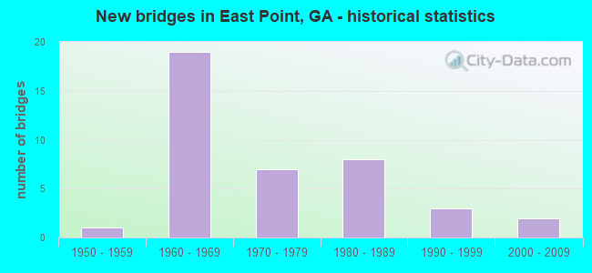
- New bridges - historical statistics
- 11950-1959
- 191960-1969
- 71970-1979
- 81980-1989
- 31990-1999
- 22000-2009

- Reconstructed bridges - Historical Statistics
- 11970-1979
- 11980-1989
- 01990-1999
- 02000-2009
- 02010-2019
- 12020-2022


- Bridge Condition - Deck
- 63.3%Good
- 33.3%Satisfactory
- 3.3%Fair

- Bridge Condition - Superstructure
- 23.3%Very good
- 76.7%Good

- Bridge Condition - Substructure
- 3.3%Very good
- 93.3%Good
- 3.3%Satisfactory

- Bridge Condition - Channel
- 30.8%Very good
- 38.5%Good
- 7.7%Satisfactory
- 23.1%Fair
Find on map >> Show street view
Structure Number: 1210045, Location: IN EAST POINT (Lat: 33.684578, Lng: -84.440483), Route carried "on" structure: US 29, Year Built: 1962, Year Reconstructed: 1985, Status: Open, Structure Length: 2.62m (8.60ft), Average Daily Traffic: 6,590 (year 2012), Truck Traffic: 1%, Average Future Daily Traffic: 9,885 (year 2032), Design Load: HS 20+Mod, Features Intersected: M-9064 NORMAN BERRY RD
Minimum Vertical Clearance: 30+ m (98+ ft), Kilometerpoint: 32.187, Lanes on structure: 5, Lanes under structure: 4, Base Highway Network: Yes, Owner: State Highway Agency, Approaching Roadway Width: 19.5m (64.0ft), Material/Design: Prestressed concrete, Design/Construction: Stringer/Multi-beam, Number Of Spans In Main Unit: 2, Length of Maximum Span: 13.1m (43.0ft), Curb or Sidewalk Widths: Left: 2.5m (8.2ft), Right: 2.5m (8.2ft), Curb-To-Curb Width: 19.8m (65.0ft), Out-to-Out Width: 27.3m (89.6ft)
Condition: Deck: Good, Superstructure: Very good, Substructure: Good, Operating Rating: 54.4 metric tons, Method Used To Determine Operating Rating: Allowable Stress (AS), Inventory Rating: 32.6 metric tons, Method Used To Determine Inventory Rating: Allowable Stress (AS), Structural Evaluation: Better than present minimum criteria, Deck Geometry: Meets minimum limits, Underclear: Meets minimum limits, Approach Roadway Alignment: Equal to present desirable criteria, Designated Inspection Frequency: Every 24 months, Inspection Date: April 2020, Bridge Improvement Cost: $611,000, Roadway Improvement Cost: $61,000, Total Project Cost: $916,000, Deck Structure Type: Concrete Cast-file-Place
Find on map >> Show street view
Structure Number: 1210046, Location: IN NORTH EAST POINT (Lat: 33.698067, Lng: -84.429481), Route carried "on" structure: US 29, Year Built: 1983, Status: Open, Structure Length: 8.35m (27.40ft), Average Daily Traffic: 13,130 (year 2012), Truck Traffic: 1%, Average Future Daily Traffic: 19,695 (year 2032), Design Load: HS 20+Mod, Features Intersected: SR 166
Minimum Vertical Clearance: 30+ m (98+ ft), Kilometerpoint: 33.796, Lanes on structure: 5, Lanes under structure: 6, Base Highway Network: Yes, Owner: State Highway Agency, Approaching Roadway Width: 19.5m (64.0ft), Material/Design: Steel continuous, Design/Construction: Stringer/Multi-beam, Number Of Spans In Main Unit: 3, Length of Maximum Span: 34.7m (113.8ft), Curb or Sidewalk Widths: Left: 1.8m (5.9ft), Right: 1.8m (5.9ft), Curb-To-Curb Width: 19.5m (64.0ft), Out-to-Out Width: 23.8m (78.1ft)
Condition: Deck: Satisfactory, Superstructure: Good, Substructure: Good, Operating Rating: 46.2 metric tons, Method Used To Determine Operating Rating: Allowable Stress (AS), Inventory Rating: 32.6 metric tons, Method Used To Determine Inventory Rating: Allowable Stress (AS), Structural Evaluation: Better than present minimum criteria, Deck Geometry: Meets minimum limits, Underclear: High priority of corrective action, Approach Roadway Alignment: Equal to present desirable criteria, Designated Inspection Frequency: Every 24 months, Inspection Date: April 2020, Bridge Improvement Cost: $1,946,000, Roadway Improvement Cost: $195,000, Total Project Cost: $2,920,000, Deck Structure Type: Concrete Cast-file-Place
Find on map >> Show street view
Structure Number: 121009, Location: 7.4 MI W OF ATLANTA (Lat: 33.725089, Lng: -84.514178), Route carried "on" structure: County highway 9053, Year Built: 1971, Status: Open, Structure Length: 5.85m (19.19ft), Average Daily Traffic: 18,750 (year 2011), Truck Traffic: 1%, Average Future Daily Traffic: 28,125 (year 2031), Design Load: HS 20+Mod, Features Intersected: CSX RAILROAD, Facility Carried by Structure: CASCADE ROAD
Minimum Vertical Clearance: 30+ m (98+ ft), Kilometerpoint: 6.437, Lanes on structure: 4, Base Highway Network: Yes, Owner: City or Municipal Highway Agency, Approaching Roadway Width: 15.8m (51.8ft), Skew: 3 degrees, Material/Design: Steel continuous, Design/Construction: Stringer/Multi-beam, Number Of Spans In Main Unit: 3, Length of Maximum Span: 21.3m (69.9ft), Curb or Sidewalk Widths: Left: 1.2m (3.9ft), Right: 1.2m (3.9ft), Curb-To-Curb Width: 14.6m (47.9ft), Out-to-Out Width: 16.2m (53.1ft)
Condition: Deck: Satisfactory, Superstructure: Good, Substructure: Good, Operating Rating: 58.9 metric tons, Method Used To Determine Operating Rating: Load Factor (LF), Inventory Rating: 35.3 metric tons, Method Used To Determine Inventory Rating: Load Factor (LF), Structural Evaluation: Better than present minimum criteria, Deck Geometry: High priority of replacement, Underclear: Equal to present minimum criteria, Approach Roadway Alignment: Equal to present desirable criteria, Designated Inspection Frequency: Every 24 months, Inspection Date: July 2020, Bridge Improvement Cost: $1,159,000, Roadway Improvement Cost: $116,000, Total Project Cost: $1,739,000, Deck Structure Type: Concrete Cast-file-Place
Find on map >> Show street view
Structure Number: 1210096, Location: IN NW EAST POINT (Lat: 33.697694, Lng: -84.465747), Route carried "on" structure: State highway 154, Year Built: 1964, Status: Open, Structure Length: 0.82m (2.69ft), Average Daily Traffic: 51,160 (year 2012), Truck Traffic: 1%, Average Future Daily Traffic: 76,740 (year 2032), Design Load: HS 20+Mod, Features Intersected: SOUTH UTOY CREEK
Minimum Vertical Clearance: 30+ m (98+ ft), Kilometerpoint: 38.624, Lanes on structure: 4, Base Highway Network: Yes, Owner: State Highway Agency, Approaching Roadway Width: 21.9m (71.9ft), Skew: 31 degrees, Material/Design: Concrete, Design/Construction: Culvert, Number Of Spans In Main Unit: 3, Length of Maximum Span: 2.4m (7.9ft)
Condition: Channel: Fair, Culverts: Good, Operating Rating: 59.8 metric tons, Method Used To Determine Operating Rating: Load Factor (LF), Inventory Rating: 36.2 metric tons, Method Used To Determine Inventory Rating: Load Factor (LF), Structural Evaluation: Better than present minimum criteria, Waterway Adequacy: Somewhat better than minimum adequacy, Approach Roadway Alignment: Equal to present desirable criteria, Designated Inspection Frequency: Every 24 months, Inspection Date: March 2021
Find on map >> Show street view
Structure Number: 1210097, Location: IN NORTH EAST POINT (Lat: 33.699258, Lng: -84.457378), Route carried "on" structure: State highway 154, Year Built: 1965, Status: Open, Structure Length: 5.00m (16.40ft), Average Daily Traffic: 36,100 (year 2012), Truck Traffic: 5%, Average Future Daily Traffic: 54,150 (year 2032), Design Load: HS 20+Mod, Features Intersected: M-9071 DELOWE DRIVE
Minimum Vertical Clearance: 30+ m (98+ ft), Kilometerpoint: 40.234, Lanes on structure: 2, Lanes under structure: 4, Base Highway Network: Yes, Owner: State Highway Agency, Approaching Roadway Width: 11.6m (38.1ft), Skew: 11 degrees, Material/Design: Prestressed concrete, Design/Construction: Stringer/Multi-beam, Number Of Spans In Main Unit: 3, Length of Maximum Span: 19.8m (65.0ft), Curb or Sidewalk Widths: Left: 0.6m (2.0ft), Right: 0.6m (2.0ft), Curb-To-Curb Width: 8.5m (27.9ft), Out-to-Out Width: 10.3m (33.8ft)
Condition: Deck: Satisfactory, Superstructure: Good, Substructure: Good, Operating Rating: 64.4 metric tons, Method Used To Determine Operating Rating: Load Factor (LF), Inventory Rating: 38.1 metric tons, Method Used To Determine Inventory Rating: Load Factor (LF), Structural Evaluation: Better than present minimum criteria, Deck Geometry: High priority of replacement, Underclear: Meets minimum limits, Approach Roadway Alignment: Equal to present desirable criteria, Length Of Structure Improvement: 11.43m (37.50ft), Designated Inspection Frequency: Every 24 months, Inspection Date: March 2021, Bridge Improvement Cost: $369,000, Roadway Improvement Cost: $113,000, Total Project Cost: $567,000, Deck Structure Type: Concrete Cast-file-Place
Find on map >> Show street view
Structure Number: 1210098, Location: IN NORTH EAST POINT (Lat: 33.699439, Lng: -84.457339), Route carried "on" structure: State highway 154, Year Built: 1965, Status: Open, Structure Length: 5.00m (16.40ft), Average Daily Traffic: 36,100 (year 2012), Truck Traffic: 5%, Average Future Daily Traffic: 54,150 (year 2032), Design Load: HS 20+Mod, Features Intersected: M-9071 DELOWE DRIVE
Minimum Vertical Clearance: 30+ m (98+ ft), Kilometerpoint: 40.234, Lanes on structure: 2, Lanes under structure: 4, Base Highway Network: Yes, Owner: State Highway Agency, Approaching Roadway Width: 11.6m (38.1ft), Skew: 11 degrees, Material/Design: Prestressed concrete, Design/Construction: Stringer/Multi-beam, Number Of Spans In Main Unit: 3, Length of Maximum Span: 19.8m (65.0ft), Curb or Sidewalk Widths: Left: 0.6m (2.0ft), Right: 0.6m (2.0ft), Curb-To-Curb Width: 8.5m (27.9ft), Out-to-Out Width: 10.3m (33.8ft)
Condition: Deck: Satisfactory, Superstructure: Good, Substructure: Good, Operating Rating: 64.4 metric tons, Method Used To Determine Operating Rating: Load Factor (LF), Inventory Rating: 37.1 metric tons, Method Used To Determine Inventory Rating: Load Factor (LF), Structural Evaluation: Better than present minimum criteria, Deck Geometry: High priority of replacement, Underclear: Meets minimum limits, Approach Roadway Alignment: Equal to present desirable criteria, Length Of Structure Improvement: 11.43m (37.50ft), Designated Inspection Frequency: Every 24 months, Inspection Date: March 2021, Bridge Improvement Cost: $566,000, Roadway Improvement Cost: $116,000, Total Project Cost: $786,000, Deck Structure Type: Concrete Cast-file-Place
Find on map >> Show street view
Structure Number: 1210099, Location: IN NORTH EAST POINT (Lat: 33.698014, Lng: -84.448456), Route carried "on" structure: State highway 154, Year Built: 1965, Status: Open, Structure Length: 5.43m (17.81ft), Average Daily Traffic: 36,100 (year 2012), Truck Traffic: 5%, Average Future Daily Traffic: 54,150 (year 2032), Design Load: HS 20+Mod, Features Intersected: M-9072 STANTON ROAD
Minimum Vertical Clearance: 30+ m (98+ ft), Kilometerpoint: 40.234, Lanes on structure: 2, Lanes under structure: 4, Base Highway Network: Yes, Owner: State Highway Agency, Approaching Roadway Width: 11.6m (38.1ft), Skew: 11 degrees, Material/Design: Prestressed concrete, Design/Construction: Stringer/Multi-beam, Number Of Spans In Main Unit: 3, Length of Maximum Span: 19.5m (64.0ft), Curb or Sidewalk Widths: Left: 0.6m (2.0ft), Right: 0.6m (2.0ft), Curb-To-Curb Width: 8.5m (27.9ft), Out-to-Out Width: 10.4m (34.1ft)
Condition: Deck: Satisfactory, Superstructure: Good, Substructure: Good, Operating Rating: 63.5 metric tons, Method Used To Determine Operating Rating: Load Factor (LF), Inventory Rating: 38.1 metric tons, Method Used To Determine Inventory Rating: Load Factor (LF), Structural Evaluation: Better than present minimum criteria, Deck Geometry: High priority of replacement, Underclear: Meets minimum limits, Approach Roadway Alignment: Equal to present desirable criteria, Length Of Structure Improvement: 11.86m (38.91ft), Designated Inspection Frequency: Every 24 months, Inspection Date: March 2021, Bridge Improvement Cost: $507,000, Roadway Improvement Cost: $129,000, Total Project Cost: $740,000, Deck Structure Type: Concrete Cast-file-Place
Find on map >> Show street view
Structure Number: 12101, Location: IN NORTH EAST POINT (Lat: 33.698189, Lng: -84.448408), Route carried "on" structure: State highway 154, Year Built: 1965, Status: Open, Structure Length: 5.36m (17.59ft), Average Daily Traffic: 36,100 (year 2012), Truck Traffic: 5%, Average Future Daily Traffic: 54,150 (year 2032), Design Load: HS 20+Mod, Features Intersected: M-9072 STANTON ROAD
Minimum Vertical Clearance: 30+ m (98+ ft), Kilometerpoint: 40.234, Lanes on structure: 2, Lanes under structure: 4, Base Highway Network: Yes, Owner: State Highway Agency, Approaching Roadway Width: 11.6m (38.1ft), Skew: 11 degrees, Material/Design: Prestressed concrete, Design/Construction: Stringer/Multi-beam, Number Of Spans In Main Unit: 3, Length of Maximum Span: 19.5m (64.0ft), Curb or Sidewalk Widths: Left: 0.6m (2.0ft), Right: 0.6m (2.0ft), Curb-To-Curb Width: 8.5m (27.9ft), Out-to-Out Width: 10.4m (34.1ft)
Condition: Deck: Satisfactory, Superstructure: Good, Substructure: Good, Operating Rating: 61.6 metric tons, Method Used To Determine Operating Rating: Load Factor (LF), Inventory Rating: 37.1 metric tons, Method Used To Determine Inventory Rating: Load Factor (LF), Structural Evaluation: Better than present minimum criteria, Deck Geometry: High priority of replacement, Underclear: Meets minimum limits, Approach Roadway Alignment: Equal to present desirable criteria, Length Of Structure Improvement: 11.80m (38.71ft), Designated Inspection Frequency: Every 24 months, Inspection Date: March 2021, Bridge Improvement Cost: $607,000, Roadway Improvement Cost: $119,000, Total Project Cost: $838,000, Deck Structure Type: Concrete Cast-file-Place
Find on map >> Show street view
Structure Number: 1210223, Location: IN EAST POINT (Lat: 33.652478, Lng: -84.497608), Route carried "on" structure: Interstate 285, Year Built: 1966, Year Reconstructed: 1981, Status: Open, Structure Length: 4.27m (14.01ft), Average Daily Traffic: 130,030 (year 2012), Truck Traffic: 1%, Average Future Daily Traffic: 195,045 (year 2032), Design Load: HS 20+Mod, Features Intersected: SOUTH FORK CAMP CREEK
Minimum Vertical Clearance: 30+ m (98+ ft), Kilometerpoint: 4.828, Lanes on structure: 10, Base Highway Network: Yes, Owner: State Highway Agency, Approaching Roadway Width: 41.8m (137.1ft), Skew: 31 degrees, Material/Design: Concrete, Design/Construction: Tee Beam, Number Of Spans In Main Unit: 5, Length of Maximum Span: 8.5m (27.9ft), Curb-To-Curb Width: 43.7m (143.4ft), Out-to-Out Width: 45.7m (149.9ft)
Condition: Deck: Satisfactory, Superstructure: Good, Substructure: Satisfactory, Channel: Fair, Operating Rating: 26.3 metric tons, Method Used To Determine Operating Rating: Load Factor (LF), Inventory Rating: 16.3 metric tons, Method Used To Determine Inventory Rating: Load Factor (LF), Structural Evaluation: Meets minimum limits, Deck Geometry: Better than present minimum criteria, Waterway Adequacy: Equal to present desirable criteria, Approach Roadway Alignment: Equal to present desirable criteria, Designated Inspection Frequency: Every 24 months, Inspection Date: March 2021, Deck Structure Type: Concrete Cast-file-Place
Find on map >> Show street view
Structure Number: 1210273, Location: 7.3 MI N OF UNION CITY (Lat: 33.657308, Lng: -84.555989), Route carried "on" structure: County highway 9069, Year Built: 1952, Status: Open, Structure Length: 0.98m (3.22ft), Average Daily Traffic: 5,510 (year 2011), Truck Traffic: 1%, Average Future Daily Traffic: 8,265 (year 2031), Design Load: H 15, Features Intersected: WOLF CREEK, Facility Carried by Structure: BUTNER ROAD
Minimum Vertical Clearance: 30+ m (98+ ft), Kilometerpoint: 12.875, Lanes on structure: 2, Base Highway Network: Yes, Owner: City or Municipal Highway Agency, Approaching Roadway Width: 7.3m (24.0ft), Material/Design: Concrete, Design/Construction: Culvert, Number Of Spans In Main Unit: 3, Length of Maximum Span: 3.0m (9.8ft)
Condition: Channel: Good, Culverts: Good, Operating Rating: 41.7 metric tons, Method Used To Determine Operating Rating: Field evaluation and documented engineering judgment, Inventory Rating: 24.4 metric tons, Method Used To Determine Inventory Rating: Field evaluation and documented engineering judgment, Structural Evaluation: Equal to present minimum criteria, Waterway Adequacy: Equal to present minimum criteria, Approach Roadway Alignment: Equal to present desirable criteria, Length Of Structure Improvement: 7.41m (24.31ft), Designated Inspection Frequency: Every 24 months, Inspection Date: July 2020, Bridge Improvement Cost: $125,000, Roadway Improvement Cost: $13,000, Total Project Cost: $188,000
Find on map >> Show street view
Structure Number: 121031, Location: IN NW ROSWELL-OLD SR 140 (Lat: 34.034847, Lng: -84.361319), Route carried "on" structure: County highway 9406, Year Built: 1977, Status: Open, Structure Length: 0.70m (2.30ft), Average Daily Traffic: 11,680 (year 2011), Truck Traffic: 1%, Average Future Daily Traffic: 17,520 (year 2031), Design Load: HS 20+Mod, Features Intersected: HOGWALLER CREEK, Facility Carried by Structure: CRABAPPLE ROAD
Minimum Vertical Clearance: 30+ m (98+ ft), Kilometerpoint: 1.609, Lanes on structure: 2, Base Highway Network: Yes, Owner: City or Municipal Highway Agency, Approaching Roadway Width: 7.6m (24.9ft), Material/Design: Concrete, Design/Construction: Culvert, Number Of Spans In Main Unit: 3, Length of Maximum Span: 2.1m (6.9ft), Curb or Sidewalk Widths: Left: 0.0m, Right: 1.2m (3.9ft)
Condition: Channel: Good, Culverts: Good, Operating Rating: 55.3 metric tons, Method Used To Determine Operating Rating: Field evaluation and documented engineering judgment, Inventory Rating: 32.6 metric tons, Method Used To Determine Inventory Rating: Field evaluation and documented engineering judgment, Structural Evaluation: Better than present minimum criteria, Waterway Adequacy: Better than present minimum criteria, Approach Roadway Alignment: Equal to present desirable criteria, Designated Inspection Frequency: Every 24 months, Inspection Date: September 2021, Bridge Improvement Cost: $90,000, Roadway Improvement Cost: $9,000, Total Project Cost: $135,000
Find on map >> Show street view
Structure Number: 1210313, Location: IN SW ATLANTA (Lat: 33.697419, Lng: -84.483028), Route carried "on" structure: City street 3018, Year Built: 1965, Status: Open, Structure Length: 6.25m (20.51ft), Average Daily Traffic: 1,930 (year 2012), Truck Traffic: 1%, Average Future Daily Traffic: 2,895 (year 2032), Design Load: HS 20+Mod, Features Intersected: SR 154, Facility Carried by Structure: MAXWELL DRIVE
Minimum Vertical Clearance: 30+ m (98+ ft), Kilometerpoint: 0.000, Lanes on structure: 2, Lanes under structure: 4, Base Highway Network: Yes, Owner: State Highway Agency, Approaching Roadway Width: 9.8m (32.2ft), Skew: 2 degrees, Material/Design: Prestressed concrete, Design/Construction: Stringer/Multi-beam, Number Of Spans In Main Unit: 4, Length of Maximum Span: 18.3m (60.0ft), Curb or Sidewalk Widths: Left: 2.7m (8.9ft), Right: 2.7m (8.9ft), Curb-To-Curb Width: 9.8m (32.2ft), Out-to-Out Width: 15.8m (51.8ft)
Condition: Deck: Satisfactory, Superstructure: Good, Substructure: Good, Operating Rating: 38.1 metric tons, Method Used To Determine Operating Rating: Allowable Stress (AS), Inventory Rating: 22.6 metric tons, Method Used To Determine Inventory Rating: Allowable Stress (AS), Structural Evaluation: Equal to present minimum criteria, Deck Geometry: Somewhat better than minimum adequacy, Underclear: Meets minimum limits, Approach Roadway Alignment: Equal to present desirable criteria, Designated Inspection Frequency: Every 24 months, Inspection Date: March 2021, Deck Structure Type: Concrete Cast-file-Place
Find on map >> Show street view
Structure Number: 1210315, Location: IN EAST POINT (Lat: 33.660719, Lng: -84.497558), Route carried "on" structure: City street 3089, Year Built: 1966, Status: Open, Structure Length: 9.72m (31.89ft), Average Daily Traffic: 1,930 (year 2012), Truck Traffic: 1%, Average Future Daily Traffic: 2,895 (year 2032), Design Load: HS 20+Mod, Features Intersected: I-285 (SR 407), Facility Carried by Structure: REDWINE ROAD
Minimum Vertical Clearance: 30+ m (98+ ft), Kilometerpoint: 1.609, Lanes on structure: 2, Lanes under structure: 9, Base Highway Network: Yes, Owner: State Highway Agency, Approaching Roadway Width: 9.8m (32.2ft), Material/Design: Steel, Design/Construction: Stringer/Multi-beam, Number Of Spans In Main Unit: 4, Length of Maximum Span: 27.1m (88.9ft), Curb or Sidewalk Widths: Left: 0.6m (2.0ft), Right: 1.5m (4.9ft), Curb-To-Curb Width: 8.5m (27.9ft), Out-to-Out Width: 11.6m (38.1ft)
Condition: Deck: Satisfactory, Superstructure: Good, Substructure: Good, Operating Rating: 54.4 metric tons, Method Used To Determine Operating Rating: Load Factor (LF), Inventory Rating: 32.6 metric tons, Method Used To Determine Inventory Rating: Load Factor (LF), Structural Evaluation: Better than present minimum criteria, Deck Geometry: Somewhat better than minimum adequacy, Underclear: Meets minimum limits, Approach Roadway Alignment: Equal to present desirable criteria, Designated Inspection Frequency: Every 24 months, Inspection Date: March 2021, Deck Structure Type: Concrete Cast-file-Place
Find on map >> Show street view
Structure Number: 1210318, Location: IN SW ATLANTA (Lat: 33.697836, Lng: -84.474872), Route carried "on" structure: City street 9000, Year Built: 1965, Status: Open, Structure Length: 5.55m (18.21ft), Average Daily Traffic: 1,100 (year 2007), Truck Traffic: 1%, Average Future Daily Traffic: 1,650 (year 2030), Design Load: HS 20+Mod, Features Intersected: SR 154 LAKEWOOD F'WAY, Facility Carried by Structure: DODSON DRIVE
Minimum Vertical Clearance: 30+ m (98+ ft), Kilometerpoint: 8.047, Lanes on structure: 2, Lanes under structure: 4, Base Highway Network: Yes, Owner: State Highway Agency, Approaching Roadway Width: 6.1m (20.0ft), Skew: 1 degrees, Material/Design: Prestressed concrete, Design/Construction: Stringer/Multi-beam, Number Of Spans In Main Unit: 4, Length of Maximum Span: 17.4m (57.1ft), Curb or Sidewalk Widths: Left: 1.5m (4.9ft), Right: 1.5m (4.9ft), Curb-To-Curb Width: 8.5m (27.9ft), Out-to-Out Width: 12.1m (39.7ft)
Condition: Deck: Good, Superstructure: Good, Substructure: Good, Operating Rating: 52.6 metric tons, Method Used To Determine Operating Rating: Load Factor (LF), Inventory Rating: 31.7 metric tons, Method Used To Determine Inventory Rating: Load Factor (LF), Structural Evaluation: Better than present minimum criteria, Deck Geometry: Somewhat better than minimum adequacy, Underclear: Equal to present minimum criteria, Approach Roadway Alignment: Equal to present desirable criteria, Designated Inspection Frequency: Every 24 months, Inspection Date: March 2021, Deck Structure Type: Concrete Cast-file-Place
Find on map >> Show street view
Structure Number: 1210353, Location: IN COLLEGE PARK (Lat: 33.660928, Lng: -84.428319), Route carried "on" structure: City street 9064, Year Built: 1963, Status: Open, Structure Length: 7.25m (23.79ft), Average Daily Traffic: 2,640 (year 2012), Truck Traffic: 1%, Average Future Daily Traffic: 3,960 (year 2032), Design Load: HS 20+Mod, Features Intersected: I-85, Facility Carried by Structure: NORMAN BERRY DR
Minimum Vertical Clearance: 30+ m (98+ ft), Kilometerpoint: 0.000, Lanes on structure: 2, Lanes under structure: 7, Base Highway Network: Yes, Owner: State Highway Agency, Approaching Roadway Width: 8.5m (27.9ft), Skew: 4 degrees, Material/Design: Steel continuous, Design/Construction: Stringer/Multi-beam, Number Of Spans In Main Unit: 4, Length of Maximum Span: 26.8m (87.9ft), Curb or Sidewalk Widths: Left: 1.5m (4.9ft), Right: 1.5m (4.9ft), Curb-To-Curb Width: 8.5m (27.9ft), Out-to-Out Width: 12.2m (40.0ft)
Condition: Deck: Good, Superstructure: Good, Substructure: Good, Operating Rating: 58.9 metric tons, Method Used To Determine Operating Rating: Load Factor (LF), Inventory Rating: 35.3 metric tons, Method Used To Determine Inventory Rating: Load Factor (LF), Structural Evaluation: Better than present minimum criteria, Deck Geometry: Meets minimum limits, Underclear: Meets minimum limits, Approach Roadway Alignment: Better than present minimum criteria, Designated Inspection Frequency: Every 24 months, Inspection Date: December 2021, Deck Structure Type: Concrete Cast-file-Place, Wearing Surface/Protective System: Wearing Surface: Epoxy Overlay
Find on map >> Show street view
Structure Number: 1210358, Location: IN NORTH EAST POINT (Lat: 33.701528, Lng: -84.447550), Route carried "on" structure: City street 9072, Year Built: 1964, Status: Open, Structure Length: 0.88m (2.89ft), Average Daily Traffic: 4,940 (year 2011), Truck Traffic: 1%, Average Future Daily Traffic: 7,410 (year 2031), Design Load: H 15, Features Intersected: SOUTH UTOY CREEK, Facility Carried by Structure: STANTON ROAD
Minimum Vertical Clearance: 30+ m (98+ ft), Kilometerpoint: 3.219, Lanes on structure: 2, Base Highway Network: Yes, Owner: City or Municipal Highway Agency, Approaching Roadway Width: 7.3m (24.0ft), Material/Design: Concrete, Design/Construction: Culvert, Number Of Spans In Main Unit: 3, Length of Maximum Span: 2.7m (8.9ft), Curb or Sidewalk Widths: Left: 2.7m (8.9ft), Right: 2.7m (8.9ft)
Condition: Channel: Good, Culverts: Good, Operating Rating: 41.7 metric tons, Method Used To Determine Operating Rating: Field evaluation and documented engineering judgment, Inventory Rating: 24.4 metric tons, Method Used To Determine Inventory Rating: Field evaluation and documented engineering judgment, Structural Evaluation: Equal to present minimum criteria, Waterway Adequacy: Superior to present desirable criteria, Approach Roadway Alignment: Equal to present desirable criteria, Designated Inspection Frequency: Every 24 months, Inspection Date: April 2020, Bridge Improvement Cost: $113,000, Roadway Improvement Cost: $11,000, Total Project Cost: $170,000
Find on map >> Show street view
Structure Number: 121036, Location: IN ATLANTA (Lat: 33.766928, Lng: -84.388097), Route carried "on" structure: City street 9073, Year Built: 1980, Status: Open, Structure Length: 6.68m (21.92ft), Average Daily Traffic: 7,300 (year 2012), Truck Traffic: 1%, Average Future Daily Traffic: 10,950 (year 2032), Design Load: HS 20+Mod, Features Intersected: I-75, Facility Carried by Structure: SPRING STREET
Minimum Vertical Clearance: 30+ m (98+ ft), Kilometerpoint: 3.219, Lanes on structure: 4, Lanes under structure: 13, Base Highway Network: Yes, Owner: State Highway Agency, Approaching Roadway Width: 11.9m (39.0ft), Skew: 10 degrees, Material/Design: Steel, Design/Construction: Stringer/Multi-beam, Number Of Spans In Main Unit: 1, Length of Maximum Span: 66.8m (219.2ft), Curb or Sidewalk Widths: Left: 2.4m (7.9ft), Right: 2.4m (7.9ft), Curb-To-Curb Width: 15.8m (51.8ft), Out-to-Out Width: 21.5m (70.5ft)
Condition: Deck: Good, Superstructure: Good, Substructure: Good, Operating Rating: 89.8 metric tons, Method Used To Determine Operating Rating: Load Factor (LF), Inventory Rating: 59.8 metric tons, Method Used To Determine Inventory Rating: Load Factor (LF), Structural Evaluation: Better than present minimum criteria, Deck Geometry: Meets minimum limits, Underclear: Equal to present minimum criteria, Approach Roadway Alignment: Equal to present desirable criteria, Designated Inspection Frequency: Every 24 months, Inspection Date: May 2021, Bridge Improvement Cost: $1,322,000, Roadway Improvement Cost: $132,000, Total Project Cost: $1,984,000, Deck Structure Type: Concrete Precast Panels, Wearing Surface/Protective System: Deck Protection: Epoxy Coated Reinforcing
Find on map >> Show street view
Structure Number: 1210362, Location: IN SOUTH WEST ATLANTA (Lat: 33.655872, Lng: -84.521647), Route carried "on" structure: County highway 9074, Year Built: 1976, Status: Open, Structure Length: 4.15m (13.62ft), Average Daily Traffic: 12,880 (year 2011), Truck Traffic: 1%, Average Future Daily Traffic: 19,320 (year 2031), Design Load: HS 20+Mod, Features Intersected: CAMP CREEK, Facility Carried by Structure: WELCOME ALL ROAD
Minimum Vertical Clearance: 30+ m (98+ ft), Kilometerpoint: 4.828, Lanes on structure: 2, Base Highway Network: Yes, Owner: City or Municipal Highway Agency, Approaching Roadway Width: 8.5m (27.9ft), Material/Design: Concrete, Design/Construction: Tee Beam, Number Of Spans In Main Unit: 4, Length of Maximum Span: 10.4m (34.1ft), Curb or Sidewalk Widths: Left: 1.2m (3.9ft), Right: 1.2m (3.9ft), Curb-To-Curb Width: 8.5m (27.9ft), Out-to-Out Width: 11.8m (38.7ft)
Condition: Deck: Good, Superstructure: Good, Substructure: Good, Channel: Very good, Operating Rating: 45.3 metric tons, Method Used To Determine Operating Rating: Load Factor (LF), Inventory Rating: 27.2 metric tons, Method Used To Determine Inventory Rating: Load Factor (LF), Structural Evaluation: Equal to present minimum criteria, Deck Geometry: High priority of replacement, Waterway Adequacy: Superior to present desirable criteria, Approach Roadway Alignment: Equal to present desirable criteria, Designated Inspection Frequency: Every 24 months, Inspection Date: July 2020, Bridge Improvement Cost: $531,000, Roadway Improvement Cost: $53,000, Total Project Cost: $797,000, Deck Structure Type: Concrete Cast-file-Place
Find on map >> Show street view
Structure Number: 1210363, Location: 4.2 MI W OF COLLEGE PARK (Lat: 33.657097, Lng: -84.521778), Route carried "on" structure: City street 9074, Year Built: 1977, Status: Open, Structure Length: 3.29m (10.79ft), Average Daily Traffic: 1,510 (year 2012), Truck Traffic: 1%, Average Future Daily Traffic: 2,265 (year 2032), Design Load: HS 20+Mod, Features Intersected: SR 6 CAMP CREEK PKWY., Facility Carried by Structure: WELCOME ALL ROAD
Minimum Vertical Clearance: 30+ m (98+ ft), Kilometerpoint: 4.828, Lanes on structure: 2, Lanes under structure: 4, Base Highway Network: Yes, Owner: State Highway Agency, Approaching Roadway Width: 12.2m (40.0ft), Skew: 4 degrees, Material/Design: Steel, Design/Construction: Stringer/Multi-beam, Number Of Spans In Main Unit: 2, Length of Maximum Span: 16.5m (54.1ft), Curb or Sidewalk Widths: Left: 1.2m (3.9ft), Right: 1.2m (3.9ft), Curb-To-Curb Width: 12.2m (40.0ft), Out-to-Out Width: 15.4m (50.5ft)
Condition: Deck: Good, Superstructure: Good, Substructure: Good, Operating Rating: 62.5 metric tons, Method Used To Determine Operating Rating: Load Factor (LF), Inventory Rating: 37.1 metric tons, Method Used To Determine Inventory Rating: Load Factor (LF), Structural Evaluation: Better than present minimum criteria, Deck Geometry: Better than present minimum criteria, Underclear: Meets minimum limits, Approach Roadway Alignment: Equal to present desirable criteria, Designated Inspection Frequency: Every 24 months, Inspection Date: July 2020, Bridge Improvement Cost: $422,000, Roadway Improvement Cost: $42,000, Total Project Cost: $633,000, Deck Structure Type: Concrete Cast-file-Place
Find on map >> Show street view
Structure Number: 1210366, Location: IN EAST POINT (Lat: 33.636456, Lng: -84.492139), Route carried "on" structure: City street 9082, Year Built: 1967, Status: Open, Structure Length: 9.24m (30.31ft), Average Daily Traffic: 10,550 (year 2012), Truck Traffic: 1%, Average Future Daily Traffic: 15,825 (year 2032), Design Load: HS 20+Mod, Features Intersected: I-285 (SR 407), Facility Carried by Structure: WASHINGTON ROAD
Minimum Vertical Clearance: 30+ m (98+ ft), Kilometerpoint: 1.609, Lanes on structure: 4, Lanes under structure: 8, Base Highway Network: Yes, Owner: State Highway Agency, Approaching Roadway Width: 15.8m (51.8ft), Skew: 3 degrees, Material/Design: Steel, Design/Construction: Stringer/Multi-beam, Number Of Spans In Main Unit: 4, Length of Maximum Span: 34.4m (112.9ft), Curb or Sidewalk Widths: Left: 1.6m (5.2ft), Right: 1.6m (5.2ft), Curb-To-Curb Width: 15.8m (51.8ft), Out-to-Out Width: 19.7m (64.6ft)
Condition: Deck: Fair, Superstructure: Good, Substructure: Good, Operating Rating: 28.1 metric tons, Method Used To Determine Operating Rating: Load Factor (LF), Inventory Rating: 16.3 metric tons, Method Used To Determine Inventory Rating: Load Factor (LF), Structural Evaluation: Meets minimum limits, Deck Geometry: Meets minimum limits, Underclear: Meets minimum limits, Approach Roadway Alignment: Equal to present desirable criteria, Designated Inspection Frequency: Every 24 months, Inspection Date: March 2021, Deck Structure Type: Concrete Cast-file-Place
Find on map >> Show street view
Structure Number: 1210367, Location: IN EAST POINT (Lat: 33.650475, Lng: -84.489561), Route carried "on" structure: City street 9082, Year Built: 1987, Status: Open, Structure Length: 0.98m (3.22ft), Average Daily Traffic: 7,610 (year 2008), Truck Traffic: 1%, Average Future Daily Traffic: 11,415 (year 2030), Design Load: HS 20+Mod, Features Intersected: FUR CREEK, Facility Carried by Structure: WASHINGTON ROAD
Minimum Vertical Clearance: 30+ m (98+ ft), Kilometerpoint: 3.219, Lanes on structure: 5, Base Highway Network: Yes, Owner: City or Municipal Highway Agency, Approaching Roadway Width: 19.5m (64.0ft), Material/Design: Concrete, Design/Construction: Culvert, Number Of Spans In Main Unit: 3, Length of Maximum Span: 3.0m (9.8ft)
Condition: Channel: Satisfactory, Culverts: Good, Operating Rating: 55.3 metric tons, Method Used To Determine Operating Rating: Field evaluation and documented engineering judgment, Inventory Rating: 32.6 metric tons, Method Used To Determine Inventory Rating: Field evaluation and documented engineering judgment, Structural Evaluation: Better than present minimum criteria, Waterway Adequacy: Equal to present desirable criteria, Approach Roadway Alignment: Equal to present desirable criteria, Designated Inspection Frequency: Every 24 months, Inspection Date: July 2020, Bridge Improvement Cost: $227,000, Roadway Improvement Cost: $23,000, Total Project Cost: $341,000
Find on map >> Show street view
Structure Number: 1210368, Location: IN EAST POINT (Lat: 33.652239, Lng: -84.488619), Route carried "on" structure: City street 9082, Year Built: 1987, Status: Open, Structure Length: 3.20m (10.50ft), Average Daily Traffic: 7,610 (year 2008), Truck Traffic: 1%, Average Future Daily Traffic: 11,415 (year 2030), Design Load: HS 20+Mod, Features Intersected: CAMP CREEK, Facility Carried by Structure: WASHINGTON ROAD
Minimum Vertical Clearance: 30+ m (98+ ft), Kilometerpoint: 3.219, Lanes on structure: 5, Base Highway Network: Yes, Owner: City or Municipal Highway Agency, Approaching Roadway Width: 19.5m (64.0ft), Material/Design: Concrete, Design/Construction: Tee Beam, Number Of Spans In Main Unit: 3, Length of Maximum Span: 10.7m (35.1ft), Curb or Sidewalk Widths: Left: 1.8m (5.9ft), Right: 1.8m (5.9ft), Curb-To-Curb Width: 19.5m (64.0ft), Out-to-Out Width: 23.9m (78.4ft)
Condition: Deck: Good, Superstructure: Very good, Substructure: Good, Channel: Good, Operating Rating: 49.8 metric tons, Method Used To Determine Operating Rating: Load Factor (LF), Inventory Rating: 19.9 metric tons, Method Used To Determine Inventory Rating: Load Factor (LF), Structural Evaluation: Somewhat better than minimum adequacy, Deck Geometry: Meets minimum limits, Waterway Adequacy: Superior to present desirable criteria, Approach Roadway Alignment: Equal to present desirable criteria, Designated Inspection Frequency: Every 24 months, Inspection Date: July 2020, Bridge Improvement Cost: $746,000, Roadway Improvement Cost: $75,000, Total Project Cost: $1,119,000, Deck Structure Type: Concrete Cast-file-Place
Find on map >> Show street view
Structure Number: 1210371, Location: IN EAST POINT (Lat: 33.666919, Lng: -84.428339), Route carried "on" structure: City street 9079, Year Built: 1978, Status: Open, Structure Length: 3.90m (12.80ft), Average Daily Traffic: 2,810 (year 2011), Truck Traffic: 1%, Average Future Daily Traffic: 4,215 (year 2031), Design Load: HS 20+Mod, Features Intersected: M-9064 NORMAN BERRY DR, Facility Carried by Structure: CENTRAL AVE.
Minimum Vertical Clearance: 30+ m (98+ ft), Kilometerpoint: 3.219, Lanes on structure: 2, Lanes under structure: 4, Base Highway Network: Yes, Owner: City or Municipal Highway Agency, Approaching Roadway Width: 9.1m (29.9ft), Skew: 3 degrees, Material/Design: Steel, Design/Construction: Stringer/Multi-beam, Number Of Spans In Main Unit: 3, Length of Maximum Span: 20.7m (67.9ft), Curb or Sidewalk Widths: Left: 1.5m (4.9ft), Right: 0.6m (2.0ft), Curb-To-Curb Width: 8.9m (29.2ft), Out-to-Out Width: 11.9m (39.0ft)
Condition: Deck: Satisfactory, Superstructure: Good, Substructure: Good, Operating Rating: 48.9 metric tons, Method Used To Determine Operating Rating: Load Factor (LF), Inventory Rating: 29.0 metric tons, Method Used To Determine Inventory Rating: Load Factor (LF), Structural Evaluation: Better than present minimum criteria, Deck Geometry: Meets minimum limits, Underclear: Somewhat better than minimum adequacy, Approach Roadway Alignment: Equal to present desirable criteria, Length Of Structure Improvement: 10.70m (35.10ft), Designated Inspection Frequency: Every 24 months, Inspection Date: May 2020, Bridge Improvement Cost: $500,000, Roadway Improvement Cost: $50,000, Total Project Cost: $750,000, Deck Structure Type: Concrete Cast-file-Place
Find on map >> Show street view
Structure Number: 1210373, Location: IN HAPEVILLE (Lat: 33.665119, Lng: -84.418528), Route carried "on" structure: City street 9081, Year Built: 1963, Status: Open, Structure Length: 6.89m (22.60ft), Average Daily Traffic: 4,770 (year 2012), Truck Traffic: 1%, Average Future Daily Traffic: 7,155 (year 2032), Design Load: HS 20+Mod, Features Intersected: I-85, Facility Carried by Structure: SYLVAN ROAD
Minimum Vertical Clearance: 30+ m (98+ ft), Kilometerpoint: 0.000, Lanes on structure: 2, Lanes under structure: 8, Base Highway Network: Yes, Owner: State Highway Agency, Approaching Roadway Width: 15.8m (51.8ft), Skew: 1 degrees, Material/Design: Steel continuous, Design/Construction: Stringer/Multi-beam, Number Of Spans In Main Unit: 4, Length of Maximum Span: 25.6m (84.0ft), Curb or Sidewalk Widths: Left: 1.5m (4.9ft), Right: 1.5m (4.9ft), Curb-To-Curb Width: 15.8m (51.8ft), Out-to-Out Width: 19.5m (64.0ft)
Condition: Deck: Good, Superstructure: Good, Substructure: Good, Operating Rating: 46.2 metric tons, Method Used To Determine Operating Rating: Allowable Stress (AS), Inventory Rating: 32.6 metric tons, Method Used To Determine Inventory Rating: Allowable Stress (AS), Structural Evaluation: Better than present minimum criteria, Deck Geometry: Superior to present desirable criteria, Underclear: Meets minimum limits, Approach Roadway Alignment: Better than present minimum criteria, Designated Inspection Frequency: Every 24 months, Inspection Date: March 2021, Deck Structure Type: Concrete Cast-file-Place, Wearing Surface/Protective System: Wearing Surface: Epoxy Overlay
Find on map >> Show street view
Structure Number: 1210463, Location: IN COLLEGE PARK (Lat: 33.645058, Lng: -84.449886), Route carried "on" structure: City street 9329, Year Built: 1976, Status: Open, Structure Length: 8.60m (28.22ft), Average Daily Traffic: 30,970 (year 2007), Truck Traffic: 1%, Average Future Daily Traffic: 46,455 (year 2030), Design Load: HS 20+Mod, Features Intersected: I-85- 2 I-85 RAMPS, Facility Carried by Structure: CAMP CRK PKWY NBL
Minimum Vertical Clearance: 30+ m (98+ ft), Kilometerpoint: 0.000, Lanes on structure: 2, Lanes under structure: 10, Base Highway Network: Yes, Owner: State Highway Agency, Approaching Roadway Width: 8.5m (27.9ft), Skew: 11 degrees, Material/Design: Steel continuous, Design/Construction: Stringer/Multi-beam, Number Of Spans In Main Unit: 2, Length of Maximum Span: 47.2m (154.9ft), Curb-To-Curb Width: 10.4m (34.1ft), Out-to-Out Width: 11.1m (36.4ft)
Condition: Deck: Good, Superstructure: Very good, Substructure: Good, Operating Rating: 33.5 metric tons, Method Used To Determine Operating Rating: Load Factor (LF), Inventory Rating: 19.9 metric tons, Method Used To Determine Inventory Rating: Load Factor (LF), Structural Evaluation: Somewhat better than minimum adequacy, Deck Geometry: Meets minimum limits, Underclear: Equal to present minimum criteria, Approach Roadway Alignment: Equal to present desirable criteria, Designated Inspection Frequency: Every 24 months, Inspection Date: March 2021, Bridge Improvement Cost: $1,102,000, Roadway Improvement Cost: $110,000, Total Project Cost: $1,653,000, Deck Structure Type: Concrete Cast-file-Place, Wearing Surface/Protective System: Wearing Surface: Epoxy Overlay
Find on map >> Show street view
Structure Number: 1210466, Location: IN EAST POINT (Lat: 33.656500, Lng: -84.497689), Route carried "on" structure: State highway 6, Year Built: 1966, Year Reconstructed: 2020, Status: Open, Structure Length: 7.22m (23.69ft), Average Daily Traffic: 33,240 (year 2012), Truck Traffic: 3%, Average Future Daily Traffic: 49,860 (year 2032), Design Load: HS 20+Mod, Features Intersected: I-285 (SR 407), Facility Carried by Structure: CAMP CREEK P'WAY
Minimum Vertical Clearance: 30+ m (98+ ft), Kilometerpoint: 14.613, Lanes on structure: 5, Lanes under structure: 8, Base Highway Network: Yes, Owner: State Highway Agency, Approaching Roadway Width: 25.6m (84.0ft), Skew: 30 degrees, Material/Design: Steel, Design/Construction: Stringer/Multi-beam, Number Of Spans In Main Unit: 4, Length of Maximum Span: 21.3m (69.9ft), Curb-To-Curb Width: 24.4m (80.1ft), Out-to-Out Width: 29.0m (95.1ft)
Condition: Deck: Good, Superstructure: Good, Substructure: Good, Operating Rating: 48.0 metric tons, Method Used To Determine Operating Rating: Load Factor (LF), Inventory Rating: 29.0 metric tons, Method Used To Determine Inventory Rating: Load Factor (LF), Structural Evaluation: Better than present minimum criteria, Deck Geometry: Superior to present desirable criteria, Underclear: Meets minimum limits, Approach Roadway Alignment: Equal to present desirable criteria, Designated Inspection Frequency: Every 24 months, Inspection Date: March 2021, Deck Structure Type: Concrete Cast-file-Place, Wearing Surface/Protective System: Wearing Surface: Latex Concrete
Find on map >> Show street view
Structure Number: 1210596, Location: IN COLLEGE PARK (Lat: 33.652533, Lng: -84.438731), Route carried "on" structure: Interstate 85, Year Built: 1979, Status: Open, Structure Length: 0.91m (2.99ft), Average Daily Traffic: 127,920 (year 2012), Truck Traffic: 1%, Average Future Daily Traffic: 191,880 (year 2032), Design Load: HS 20+Mod, Features Intersected: FLINT RIVER TRIB
Minimum Vertical Clearance: 30+ m (98+ ft), Kilometerpoint: 117.482, Lanes on structure: 10, Base Highway Network: Yes, Owner: State Highway Agency, Approaching Roadway Width: 35.4m (116.1ft), Skew: 39 degrees, Material/Design: Concrete, Design/Construction: Culvert, Number Of Spans In Main Unit: 3, Length of Maximum Span: 2.7m (8.9ft)
Condition: Channel: Very good, Culverts: Good, Operating Rating: 55.3 metric tons, Method Used To Determine Operating Rating: Field evaluation and documented engineering judgment, Inventory Rating: 32.6 metric tons, Method Used To Determine Inventory Rating: Field evaluation and documented engineering judgment, Structural Evaluation: Better than present minimum criteria, Waterway Adequacy: Superior to present desirable criteria, Approach Roadway Alignment: Equal to present desirable criteria, Designated Inspection Frequency: Every 24 months, Inspection Date: December 2021
Find on map >> Show street view
Structure Number: 1210621, Location: IN EAST POINT CITY LIMITS (Lat: 33.689239, Lng: -84.437119), Route carried "on" structure: City street 9117, Year Built: 1985, Status: Open, Structure Length: 11.22m (36.81ft), Average Daily Traffic: 3,060 (year 2012), Truck Traffic: 1%, Average Future Daily Traffic: 4,590 (year 2032), Design Load: HS 20+Mod, Features Intersected: SR 14-M-9116-MARTA-CSX R, Facility Carried by Structure: HAROLD SHEAT PKY.
Minimum Vertical Clearance: 30+ m (98+ ft), Kilometerpoint: 1.609, Lanes on structure: 4, Lanes under structure: 7, Base Highway Network: Yes, Owner: State Highway Agency, Approaching Roadway Width: 15.5m (50.9ft), Material/Design: Prestressed concrete, Design/Construction: Stringer/Multi-beam, Number Of Spans In Main Unit: 6, Length of Maximum Span: 28.3m (92.8ft), Curb or Sidewalk Widths: Left: 1.8m (5.9ft), Right: 1.8m (5.9ft), Curb-To-Curb Width: 15.5m (50.9ft), Out-to-Out Width: 19.9m (65.3ft)
Condition: Deck: Good, Superstructure: Very good, Substructure: Good, Operating Rating: 46.2 metric tons, Method Used To Determine Operating Rating: Allowable Stress (AS), Inventory Rating: 32.6 metric tons, Method Used To Determine Inventory Rating: Allowable Stress (AS), Structural Evaluation: Better than present minimum criteria, Deck Geometry: Meets minimum limits, Underclear: Equal to present minimum criteria, Approach Roadway Alignment: Equal to present desirable criteria, Designated Inspection Frequency: Every 24 months, Inspection Date: March 2021, Bridge Improvement Cost: $2,222,000, Roadway Improvement Cost: $222,000, Total Project Cost: $3,333,000, Deck Structure Type: Concrete Cast-file-Place
Find on map >> Show street view
Structure Number: 1215183, Location: EAST POINT CITY LIMITS (Lat: 33.675378, Lng: -84.441297), Route carried "on" structure: City street 9082, Year Built: 1986, Status: Open, Structure Length: 1.83m (6.00ft), Average Daily Traffic: 11,620 (year 2011), Truck Traffic: 5%, Average Future Daily Traffic: 17,430 (year 2031), Design Load: HS 20+Mod, Features Intersected: MARTA, Facility Carried by Structure: IRENE KIDD PARKWAY
Minimum Vertical Clearance: 30+ m (98+ ft), Kilometerpoint: 9.656, Lanes on structure: 5, Base Highway Network: Yes, Owner: City or Municipal Highway Agency, Approaching Roadway Width: 19.8m (65.0ft), Material/Design: Prestressed concrete, Design/Construction: Stringer/Multi-beam, Number Of Spans In Main Unit: 1, Length of Maximum Span: 18.3m (60.0ft), Curb or Sidewalk Widths: Left: 2.1m (6.9ft), Right: 1.8m (5.9ft), Curb-To-Curb Width: 19.8m (65.0ft), Out-to-Out Width: 24.5m (80.4ft)
Condition: Deck: Good, Superstructure: Good, Substructure: Good, Operating Rating: 46.2 metric tons, Method Used To Determine Operating Rating: Allowable Stress (AS), Inventory Rating: 32.6 metric tons, Method Used To Determine Inventory Rating: Allowable Stress (AS), Structural Evaluation: Better than present minimum criteria, Deck Geometry: Meets minimum limits, Underclear: High priority of corrective action, Approach Roadway Alignment: Better than present minimum criteria, Designated Inspection Frequency: Every 24 months, Inspection Date: September 2020, Bridge Improvement Cost: $426,000, Roadway Improvement Cost: $43,000, Total Project Cost: $639,000, Deck Structure Type: Concrete Cast-file-Place
Find on map >> Show street view
Structure Number: 1215184, Location: IN EAST POINT CITY LIMITS (Lat: 33.675589, Lng: -84.439978), Route carried "on" structure: City street 9082, Year Built: 1986, Status: Open, Structure Length: 0.98m (3.22ft), Average Daily Traffic: 11,560 (year 2012), Truck Traffic: 1%, Average Future Daily Traffic: 17,340 (year 2032), Design Load: HS 20+Mod, Features Intersected: CSX RAILROAD, Facility Carried by Structure: IRENE KIDD PARKWAY
Minimum Vertical Clearance: 30+ m (98+ ft), Kilometerpoint: 9.656, Lanes on structure: 4, Base Highway Network: Yes, Owner: City or Municipal Highway Agency, Approaching Roadway Width: 19.8m (65.0ft), Material/Design: Concrete, Design/Construction: Frame, Number Of Spans In Main Unit: 1, Length of Maximum Span: 9.8m (32.2ft), Curb or Sidewalk Widths: Left: 2.4m (7.9ft), Right: 2.5m (8.2ft), Curb-To-Curb Width: 20.1m (65.9ft), Out-to-Out Width: 25.9m (85.0ft)
Condition: Deck: Good, Superstructure: Good, Substructure: Good, Operating Rating: 54.4 metric tons, Method Used To Determine Operating Rating: Load Factor (LF), Inventory Rating: 32.6 metric tons, Method Used To Determine Inventory Rating: Load Factor (LF), Structural Evaluation: Better than present minimum criteria, Deck Geometry: Better than present minimum criteria, Underclear: Equal to present minimum criteria, Approach Roadway Alignment: Equal to present desirable criteria, Designated Inspection Frequency: Every 24 months, Inspection Date: September 2020, Bridge Improvement Cost: $193,000, Roadway Improvement Cost: $19,000, Total Project Cost: $290,000, Wearing Surface/Protective System: Wearing Surface: Bituminous
Find on map >> Show street view
Structure Number: 1215185, Location: IN EAST POINT CITY LIMITS (Lat: 33.676089, Lng: -84.438858), Route carried "on" structure: City street 9082, Year Built: 1986, Status: Open, Structure Length: 2.90m (9.51ft), Average Daily Traffic: 11,620 (year 2011), Truck Traffic: 5%, Average Future Daily Traffic: 17,430 (year 2031), Design Load: HS 20+Mod, Features Intersected: CEN OF GA RAILROAD, Facility Carried by Structure: IRENE KIDD PARKWAY
Minimum Vertical Clearance: 30+ m (98+ ft), Kilometerpoint: 9.656, Lanes on structure: 5, Base Highway Network: Yes, Owner: City or Municipal Highway Agency, Approaching Roadway Width: 19.2m (63.0ft), Skew: 1 degrees, Material/Design: Prestressed concrete, Design/Construction: Stringer/Multi-beam, Number Of Spans In Main Unit: 1, Length of Maximum Span: 29.0m (95.1ft), Curb or Sidewalk Widths: Left: 1.8m (5.9ft), Right: 1.8m (5.9ft), Curb-To-Curb Width: 19.5m (64.0ft), Out-to-Out Width: 23.8m (78.1ft)
Condition: Deck: Good, Superstructure: Good, Substructure: Good, Operating Rating: 46.2 metric tons, Method Used To Determine Operating Rating: Allowable Stress (AS), Inventory Rating: 32.6 metric tons, Method Used To Determine Inventory Rating: Allowable Stress (AS), Structural Evaluation: Better than present minimum criteria, Deck Geometry: Meets minimum limits, Underclear: Better than present minimum criteria, Approach Roadway Alignment: Equal to present desirable criteria, Designated Inspection Frequency: Every 24 months, Inspection Date: September 2020, Bridge Improvement Cost: $675,000, Roadway Improvement Cost: $67,000, Total Project Cost: $1,012,000, Deck Structure Type: Concrete Cast-file-Place
Find on map >> Show street view
Structure Number: 121526, Location: IN SOUTH ALPHARETTA (Lat: 34.037500, Lng: -84.302989), Route carried "on" structure: City street 9486, Year Built: 1991, Status: Open, Structure Length: 10.36m (33.99ft), Average Daily Traffic: 20,080 (year 2011), Truck Traffic: 1%, Average Future Daily Traffic: 30,120 (year 2031), Design Load: HS 20+Mod, Features Intersected: BIG CREEK, Facility Carried by Structure: MANSELL ROAD (EBL)
Minimum Vertical Clearance: 30+ m (98+ ft), Kilometerpoint: 3.219, Lanes on structure: 2, Base Highway Network: Yes, Owner: City or Municipal Highway Agency, Approaching Roadway Width: 7.3m (24.0ft), Skew: 13 degrees, Material/Design: Prestressed concrete, Design/Construction: Stringer/Multi-beam, Number Of Spans In Main Unit: 7, Length of Maximum Span: 27.4m (89.9ft), Curb or Sidewalk Widths: Left: 0.0m, Right: 1.8m (5.9ft), Curb-To-Curb Width: 9.1m (29.9ft), Out-to-Out Width: 11.8m (38.7ft)
Condition: Deck: Good, Superstructure: Very good, Substructure: Good, Channel: Very good, Operating Rating: 64.4 metric tons, Method Used To Determine Operating Rating: Load Factor (LF), Inventory Rating: 33.5 metric tons, Method Used To Determine Inventory Rating: Load Factor (LF), Structural Evaluation: Better than present minimum criteria, Deck Geometry: Meets minimum limits, Waterway Adequacy: Equal to present desirable criteria, Approach Roadway Alignment: Better than present minimum criteria, Designated Inspection Frequency: Every 24 months, Inspection Date: September 2021, Bridge Improvement Cost: $1,328,000, Roadway Improvement Cost: $133,000, Total Project Cost: $1,993,000, Deck Structure Type: Concrete Cast-file-Place
Find on map >> Show street view
Structure Number: 1215264, Location: IN COLLEGE PARK (Lat: 33.660128, Lng: -84.429519), Route carried "on" structure: City street 6397, Year Built: 1991, Status: Open, Structure Length: 9.27m (30.41ft), Average Daily Traffic: 6,880 (year 2012), Truck Traffic: 1%, Average Future Daily Traffic: 10,320 (year 2032), Design Load: HS 20+Mod, Features Intersected: I-85, Facility Carried by Structure: BOBBY BROWN PKWY
Minimum Vertical Clearance: 30+ m (98+ ft), Kilometerpoint: 0.000, Lanes on structure: 5, Lanes under structure: 8, Base Highway Network: Yes, Owner: State Highway Agency, Approaching Roadway Width: 20.1m (65.9ft), Material/Design: Prestressed concrete, Design/Construction: Stringer/Multi-beam, Number Of Spans In Main Unit: 4, Length of Maximum Span: 36.9m (121.1ft), Curb or Sidewalk Widths: Left: 1.8m (5.9ft), Right: 1.8m (5.9ft), Curb-To-Curb Width: 20.1m (65.9ft), Out-to-Out Width: 24.5m (80.4ft)
Condition: Deck: Good, Superstructure: Good, Substructure: Good, Operating Rating: 48.9 metric tons, Method Used To Determine Operating Rating: Load Factor (LF), Inventory Rating: 29.0 metric tons, Method Used To Determine Inventory Rating: Load Factor (LF), Structural Evaluation: Better than present minimum criteria, Deck Geometry: Somewhat better than minimum adequacy, Underclear: Meets minimum limits, Approach Roadway Alignment: Equal to present desirable criteria, Designated Inspection Frequency: Every 24 months, Inspection Date: December 2021, Deck Structure Type: Concrete Cast-file-Place
Find on map >> Show street view
Structure Number: 1215268, Location: IN WEST COLLEGE PARK (Lat: 33.652789, Lng: -84.493658), Route carried "on" structure: City street 6351, Year Built: 1996, Status: Open, Structure Length: 1.83m (6.00ft), Average Daily Traffic: 2,202 (year 2011), Truck Traffic: 1%, Average Future Daily Traffic: 3,303 (year 2031), Design Load: HS 20+Mod, Features Intersected: CAMP CREEK, Facility Carried by Structure: DESERT DRIVE
Minimum Vertical Clearance: 30+ m (98+ ft), Kilometerpoint: 0.000, Lanes on structure: 2, Base Highway Network: Yes, Owner: City or Municipal Highway Agency, Approaching Roadway Width: 9.4m (30.8ft), Material/Design: Concrete, Design/Construction: Slab, Number Of Spans In Main Unit: 2, Length of Maximum Span: 9.1m (29.9ft), Curb or Sidewalk Widths: Left: 1.8m (5.9ft), Right: 1.8m (5.9ft), Curb-To-Curb Width: 8.5m (27.9ft), Out-to-Out Width: 13.0m (42.7ft)
Condition: Deck: Good, Superstructure: Good, Substructure: Good, Channel: Fair, Operating Rating: 64.4 metric tons, Method Used To Determine Operating Rating: Load Factor (LF), Inventory Rating: 38.1 metric tons, Method Used To Determine Inventory Rating: Load Factor (LF), Structural Evaluation: Better than present minimum criteria, Deck Geometry: Meets minimum limits, Waterway Adequacy: Equal to present desirable criteria, Approach Roadway Alignment: Equal to present desirable criteria, Designated Inspection Frequency: Every 24 months, Inspection Date: July 2020, Bridge Improvement Cost: $234,000, Roadway Improvement Cost: $23,000, Total Project Cost: $352,000, Deck Structure Type: Concrete Cast-file-Place
Find on map >> Show street view
Structure Number: 1215323, Location: IN EASTPOINT CITY LIMITS (Lat: 33.653142, Lng: -84.503244), Route carried "on" structure: City street 8022, Year Built: 2004, Status: Open, Structure Length: 13.72m (45.01ft), Average Daily Traffic: 1,940 (year 2011), Truck Traffic: 1%, Average Future Daily Traffic: 2,910 (year 2031), Design Load: HS 20+Mod, Features Intersected: CAMP CREEK, Facility Carried by Structure: NORTH COMMERCE DRI
Minimum Vertical Clearance: 30+ m (98+ ft), Kilometerpoint: 0.000, Lanes on structure: 2, Base Highway Network: Yes, Owner: City or Municipal Highway Agency, Approaching Roadway Width: 20.1m (65.9ft), Material/Design: Steel, Design/Construction: Stringer/Multi-beam, Number Of Spans In Main Unit: 1, Number Of Approach Spans: 2, Length of Maximum Span: 61.0m (200.1ft), Curb or Sidewalk Widths: Left: 2.3m (7.5ft), Right: 2.3m (7.5ft), Curb-To-Curb Width: 17.6m (57.7ft), Out-to-Out Width: 22.9m (75.1ft)
Condition: Deck: Good, Superstructure: Very good, Substructure: Good, Channel: Good, Operating Rating: 56.2 metric tons, Method Used To Determine Operating Rating: Field evaluation and documented engineering judgment, Inventory Rating: 32.6 metric tons, Method Used To Determine Inventory Rating: Field evaluation and documented engineering judgment, Structural Evaluation: Better than present minimum criteria, Deck Geometry: Superior to present desirable criteria, Waterway Adequacy: Equal to present desirable criteria, Approach Roadway Alignment: Equal to present desirable criteria, Designated Inspection Frequency: Every 24 months, Inspection Date: July 2020, Bridge Improvement Cost: $1,758,000, Roadway Improvement Cost: $176,000, Total Project Cost: $2,637,000, Deck Structure Type: Concrete Cast-file-Place
Find on map >> Show street view
Structure Number: 1215343, Location: IN ATLANTA CITY LIMITS (Lat: 33.660772, Lng: -84.511600), Route carried "on" structure: City street 3089, Year Built: 2005, Status: Open, Structure Length: 4.30m (14.11ft), Average Daily Traffic: 500 (year 2012), Truck Traffic: 1%, Average Future Daily Traffic: 750 (year 2032), Design Load: HS 20+Mod, Features Intersected: CAMP CREEK, Facility Carried by Structure: REDWINE ROAD
Minimum Vertical Clearance: 30+ m (98+ ft), Kilometerpoint: 0.000, Lanes on structure: 2, Owner: City or Municipal Highway Agency, Approaching Roadway Width: 10.4m (34.1ft), Material/Design: Prestressed concrete, Design/Construction: Stringer/Multi-beam, Number Of Spans In Main Unit: 3, Length of Maximum Span: 15.5m (50.9ft), Curb or Sidewalk Widths: Left: 1.8m (5.9ft), Right: 1.8m (5.9ft), Curb-To-Curb Width: 10.4m (34.1ft), Out-to-Out Width: 14.8m (48.6ft)
Condition: Deck: Good, Superstructure: Very good, Substructure: Very good, Channel: Very good, Operating Rating: 55.3 metric tons, Method Used To Determine Operating Rating: Load Factor (LF), Inventory Rating: 19.9 metric tons, Method Used To Determine Inventory Rating: Load Factor (LF), Structural Evaluation: Somewhat better than minimum adequacy, Deck Geometry: Equal to present minimum criteria, Waterway Adequacy: Equal to present desirable criteria, Approach Roadway Alignment: Equal to present desirable criteria, Designated Inspection Frequency: Every 24 months, Inspection Date: Febuary 2021, Bridge Improvement Cost: $551,000, Roadway Improvement Cost: $55,000, Total Project Cost: $826,000, Deck Structure Type: Concrete Cast-file-Place
Find on map >> Show street view
Structure Number: 1210045, Location: IN EAST POINT (Lat: 33.684578, Lng: -84.440483), Route carried "under" structure: City street 9064, Structure Length: 0. m, Average Daily Traffic: 6,850 (year 1999), Truck Traffic: 1%, Features Intersected: SR 14 (US 29) MAIN ST., Facility Carried by Structure: US 29, SR 14 MAIN
Minimum Vertical Clearance: 5.79m (19.00ft), Kilometerpoint: 4.828, Lanes on structure: 5, Length of Maximum Span: 0.0m
Find on map >> Show street view
Structure Number: 1210046, Location: IN NORTH EAST POINT (Lat: 33.698067, Lng: -84.429481), Route carried "under" structure: State highway 166, Structure Length: 0. m, Average Daily Traffic: 61,200 (year 1999), Truck Traffic: 1%, Features Intersected: SR 14 (US 29), Facility Carried by Structure: US 29 / SR. 14
Minimum Vertical Clearance: 6.24m (20.47ft), Kilometerpoint: 20.921, Lanes on structure: 5, Length of Maximum Span: 0.0m
Find on map >> Show street view
Structure Number: 1210097, Location: IN NORTH EAST POINT (Lat: 33.699258, Lng: -84.457378), Route carried "under" structure: City street 9071, Structure Length: 0. m, Average Daily Traffic: 12,200 (year 1999), Truck Traffic: 1%, Features Intersected: SR 154 NBL, Facility Carried by Structure: SR 154 / SR 166 NB
Minimum Vertical Clearance: 5.10m (16.73ft), Kilometerpoint: 3.219, Lanes on structure: 2, Length of Maximum Span: 0.0m
Find on map >> Show street view
Structure Number: 1210098, Location: IN NORTH EAST POINT (Lat: 33.699439, Lng: -84.457339), Route carried "under" structure: City street 9071, Structure Length: 0. m, Average Daily Traffic: 12,200 (year 1999), Truck Traffic: 1%, Features Intersected: SR 154 SBL, Facility Carried by Structure: SR 154 SBL
Minimum Vertical Clearance: 5.71m (18.73ft), Kilometerpoint: 3.219, Lanes on structure: 2, Length of Maximum Span: 0.0m
Find on map >> Show street view
Structure Number: 1210099, Location: IN NORTH EAST POINT (Lat: 33.698014, Lng: -84.448456), Route carried "under" structure: City street 9072, Structure Length: 0. m, Average Daily Traffic: 11,140 (year 1999), Truck Traffic: 1%, Features Intersected: SR 154 NBL, Facility Carried by Structure: SR 154 NBL
Minimum Vertical Clearance: 6.47m (21.23ft), Kilometerpoint: 3.219, Lanes on structure: 2, Length of Maximum Span: 0.0m
Find on map >> Show street view
Structure Number: 12101, Location: IN NORTH EAST POINT (Lat: 33.698189, Lng: -84.448408), Route carried "under" structure: City street 9072, Structure Length: 0. m, Average Daily Traffic: 11,140 (year 1999), Truck Traffic: 1%, Features Intersected: SR 154 SBL, Facility Carried by Structure: SR 154 SBL
Minimum Vertical Clearance: 5.38m (17.65ft), Kilometerpoint: 3.219, Lanes on structure: 2, Length of Maximum Span: 0.0m
Find on map >> Show street view
Structure Number: 1210101, Location: IN EAST POINT (Lat: 33.697769, Lng: -84.418331), Route carried "under" structure: City street 9081, Structure Length: 0. m, Average Daily Traffic: 13,600 (year 1999), Truck Traffic: 1%, Features Intersected: SR 166 LAKEWOOD FREEWAY, Facility Carried by Structure: LANKFORD PARKWAY
Minimum Vertical Clearance: 4.72m (15.49ft), Kilometerpoint: 4.828, Lanes on structure: 4, Length of Maximum Span: 0.0m
Find on map >> Show street view
Structure Number: 1210313, Location: IN SW ATLANTA (Lat: 33.697419, Lng: -84.483028), Route carried "under" structure: State highway 154, Structure Length: 0. m, Average Daily Traffic: 45,600 (year 1998), Truck Traffic: 1%, Features Intersected: CS 3018 MAXWELL DRIVE, Facility Carried by Structure: MAXWELL DRIVE
Minimum Vertical Clearance: 5.41m (17.75ft), Kilometerpoint: 37.015, Lanes on structure: 2, Length of Maximum Span: 0.0m
Find on map >> Show street view
Structure Number: 1210315, Location: IN EAST POINT (Lat: 33.660719, Lng: -84.497558), Route carried "under" structure: Interstate 285, Structure Length: 0. m, Average Daily Traffic: 127,500 (year 1998), Truck Traffic: 1%, Features Intersected: CS 3089 REDWINE ROAD, Facility Carried by Structure: REDWINE ROAD
Minimum Vertical Clearance: 9.14m (29.99ft), Kilometerpoint: 4.828, Lanes on structure: 2, Length of Maximum Span: 0.0m
Find on map >> Show street view
Structure Number: 1210318, Location: IN SW ATLANTA (Lat: 33.697836, Lng: -84.474872), Route carried "under" structure: State highway 154, Structure Length: 0. m, Average Daily Traffic: 45,600 (year 1998), Truck Traffic: 1%, Features Intersected: M-9000 DODSON DRIVE, Facility Carried by Structure: DODSON DRIVE
Minimum Vertical Clearance: 5.68m (18.64ft), Kilometerpoint: 38.624, Lanes on structure: 2, Length of Maximum Span: 0.0m
Find on map >> Show street view
Structure Number: 1210353, Location: IN COLLEGE PARK (Lat: 33.660928, Lng: -84.428319), Route carried "under" structure: Interstate 85, Structure Length: 0. m, Average Daily Traffic: 113,400 (year 2010), Truck Traffic: 1%, Features Intersected: M-9064 NORMAN BERRY DR., Facility Carried by Structure: NORMAN BERRY DR
Minimum Vertical Clearance: 5.30m (17.39ft), Kilometerpoint: 119.092, Lanes on structure: 2, Length of Maximum Span: 0.0m
Find on map >> Show street view
Structure Number: 1210363, Location: 4.2 MI W OF COLLEGE PARK (Lat: 33.657097, Lng: -84.521778), Route carried "under" structure: State highway 6, Structure Length: 0. m, Average Daily Traffic: 60,500 (year 1999), Truck Traffic: 1%, Features Intersected: M-9074 WELCOME ALL ROAD, Facility Carried by Structure: WELCOME ALL ROAD
Minimum Vertical Clearance: 6.35m (20.83ft), Kilometerpoint: 12.875, Lanes on structure: 2, Length of Maximum Span: 0.0m