Bridge Statistics for Douglasville, Georgia (GA)
Condition, Traffic, Stress, Structural Evaluation, Project Costs
- National Bridge Inventory (NBI) Statistics
- 66Number of bridges
- 856ft / 261mTotal length
- $123,805,000Total costs
- 1,497,712Total average daily traffic
- 22,120Total average daily truck traffic
- National Bridge Inventory (NBI) Registered Bridges for Douglasville
- No street view available for this location
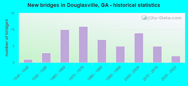
- New bridges - historical statistics
- 11940-1949
- 31950-1959
- 101960-1969
- 111970-1979
- 71980-1989
- 51990-1999
- 92000-2009
- 52010-2019
- 22020-2022

- Reconstructed bridges - Historical Statistics
- 11960-1969
- 11970-1979
- 11980-1989
- 01990-1999
- 12000-2009


- Bridge Condition - Deck
- 6.9%Very good
- 75.9%Good
- 17.2%Satisfactory

- Bridge Condition - Superstructure
- 37.9%Very good
- 48.3%Good
- 10.3%Satisfactory
- 3.4%Imminent failure

- Bridge Condition - Substructure
- 6.9%Very good
- 86.2%Good
- 3.4%Satisfactory
- 3.4%Fair

- Bridge Condition - Channel
- 2.3%Excellent
- 32.6%Very good
- 37.2%Good
- 20.9%Satisfactory
- 7.0%Fair

- Bridge Condition - Culverts
- 4.2%Very good
- 95.8%Good
Find on map >> Show street view
Structure Number: 970004, Location: IN SOUTH DOUGLASVILLE (Lat: 33.728058, Lng: -84.762242), Route carried "on" structure: State highway 5, Year Built: 1964, Year Reconstructed: 1974, Status: Open, Structure Length: 7.53m (24.70ft), Average Daily Traffic: 26,110 (year 2012), Truck Traffic: 1%, Average Future Daily Traffic: 39,165 (year 2032), Design Load: HS 20+Mod, Features Intersected: I-20
Minimum Vertical Clearance: 30+ m (98+ ft), Kilometerpoint: 20.921, Lanes on structure: 5, Lanes under structure: 6, Owner: State Highway Agency, Approaching Roadway Width: 21.3m (69.9ft), Skew: 1 degrees, Material/Design: Steel continuous, Design/Construction: Stringer/Multi-beam, Number Of Spans In Main Unit: 4, Length of Maximum Span: 21.9m (71.9ft), Curb or Sidewalk Widths: Left: 1.2m (3.9ft), Right: 0.6m (2.0ft), Curb-To-Curb Width: 21.3m (69.9ft), Out-to-Out Width: 24.0m (78.7ft)
Condition: Deck: Satisfactory, Superstructure: Good, Substructure: Good, Operating Rating: 27.2 metric tons, Method Used To Determine Operating Rating: Load Factor (LF), Inventory Rating: 16.3 metric tons, Method Used To Determine Inventory Rating: Load Factor (LF), Structural Evaluation: Meets minimum limits, Deck Geometry: Somewhat better than minimum adequacy, Underclear: Meets minimum limits, Approach Roadway Alignment: Equal to present desirable criteria, Designated Inspection Frequency: Every 24 months, Inspection Date: November 2021, Bridge Improvement Cost: $1,755,000, Roadway Improvement Cost: $175,000, Total Project Cost: $2,632,000, Deck Structure Type: Concrete Cast-file-Place
Find on map >> Show street view
Structure Number: 97001, Location: 4.2 MI E OF DOUGLASVILLE (Lat: 33.762308, Lng: -84.675528), Route carried "on" structure: County highway 9040, Year Built: 1963, Status: Open, Structure Length: 7.41m (24.31ft), Average Daily Traffic: 2,340 (year 2012), Truck Traffic: 1%, Average Future Daily Traffic: 3,510 (year 2032), Design Load: HS 15, Features Intersected: I-20, Facility Carried by Structure: NORTH COUNTY LINE
Minimum Vertical Clearance: 30+ m (98+ ft), Kilometerpoint: 1.609, Lanes on structure: 2, Lanes under structure: 6, Base Highway Network: Yes, Owner: State Highway Agency, Approaching Roadway Width: 7.3m (24.0ft), Skew: 2 degrees, Material/Design: Steel, Design/Construction: Stringer/Multi-beam, Number Of Spans In Main Unit: 4, Length of Maximum Span: 23.2m (76.1ft), Curb or Sidewalk Widths: Left: 0.7m (2.3ft), Right: 0.7m (2.3ft), Curb-To-Curb Width: 7.9m (25.9ft), Out-to-Out Width: 10.1m (33.1ft)
Condition: Deck: Good, Superstructure: Good, Substructure: Good, Operating Rating: 29.0 metric tons, Method Used To Determine Operating Rating: Load Factor (LF), Inventory Rating: 17.2 metric tons, Method Used To Determine Inventory Rating: Load Factor (LF), Structural Evaluation: Meets minimum limits, Deck Geometry: High priority of corrective action, Underclear: Somewhat better than minimum adequacy, Approach Roadway Alignment: Equal to present minimum criteria, Length Of Structure Improvement: 47.55m (156.00ft), Designated Inspection Frequency: Every 24 months, Inspection Date: November 2021, Bridge Improvement Cost: $949,000, Roadway Improvement Cost: $95,000, Total Project Cost: $1,424,000, Deck Structure Type: Concrete Cast-file-Place, Wearing Surface/Protective System: Wearing Surface: Epoxy Overlay, Deck Protection: Epoxy Coated Reinforcing
Find on map >> Show street view
Structure Number: 970011, Location: AT SW DOUGLASVILLE C.L. (Lat: 33.737169, Lng: -84.729900), Route carried "on" structure: County highway 142, Year Built: 1962, Status: Posted for load, Structure Length: 6.58m (21.59ft), Average Daily Traffic: 3,780 (year 2012), Truck Traffic: 1%, Average Future Daily Traffic: 5,670 (year 2032), Design Load: HS 15, Features Intersected: I-20, Facility Carried by Structure: PRESTLEY MILL ROAD
Minimum Vertical Clearance: 30+ m (98+ ft), Kilometerpoint: 1.609, Lanes on structure: 2, Lanes under structure: 6, Owner: State Highway Agency, Approaching Roadway Width: 7.9m (25.9ft), Skew: 1 degrees, Material/Design: Steel, Design/Construction: Stringer/Multi-beam, Number Of Spans In Main Unit: 4, Length of Maximum Span: 22.3m (73.2ft), Curb or Sidewalk Widths: Left: 0.6m (2.0ft), Right: 0.6m (2.0ft), Curb-To-Curb Width: 7.9m (25.9ft), Out-to-Out Width: 9.8m (32.2ft)
Condition: Deck: Satisfactory, Superstructure: Good, Substructure: Good, Operating Rating: 26.3 metric tons, Method Used To Determine Operating Rating: Load Factor (LF), Inventory Rating: 15.4 metric tons, Method Used To Determine Inventory Rating: Load Factor (LF), Structural Evaluation: Meets minimum limits, Deck Geometry: High priority of corrective action, Underclear: Somewhat better than minimum adequacy, Approach Roadway Alignment: Equal to present desirable criteria, Bridge Posting: Required (Relationship of Operating Rating to Maximum Legal Load: 10.0 - 19.9% below), Length Of Structure Improvement: 46.91m (153.90ft), Designated Inspection Frequency: Every 24 months, Inspection Date: November 2021, Bridge Improvement Cost: $844,000, Roadway Improvement Cost: $84,000, Total Project Cost: $1,266,000, Deck Structure Type: Concrete Cast-file-Place
Find on map >> Show street view
Structure Number: 970015, Location: DOUGLAS-FULTON CO LINE (Lat: 33.693150, Lng: -84.630389), Route carried "on" structure: State highway 166, Year Built: 1984, Status: Open, Structure Length: 16.46m (54.00ft), Average Daily Traffic: 11,520 (year 2012), Truck Traffic: 1%, Average Future Daily Traffic: 17,280 (year 2032), Design Load: HS 20+Mod, Features Intersected: CHATTAHOOCHEE RIVER
Minimum Vertical Clearance: 30+ m (98+ ft), Kilometerpoint: 33.796, Lanes on structure: 2, Owner: State Highway Agency, Approaching Roadway Width: 7.3m (24.0ft), Material/Design: Prestressed concrete, Design/Construction: Stringer/Multi-beam, Number Of Spans In Main Unit: 6, Length of Maximum Span: 27.4m (89.9ft), Curb-To-Curb Width: 14.6m (47.9ft), Out-to-Out Width: 15.5m (50.9ft)
Condition: Deck: Good, Superstructure: Good, Substructure: Good, Channel: Satisfactory, Operating Rating: 63.5 metric tons, Method Used To Determine Operating Rating: Load Factor (LF), Inventory Rating: 22.6 metric tons, Method Used To Determine Inventory Rating: Load Factor (LF), Structural Evaluation: Somewhat better than minimum adequacy, Deck Geometry: Superior to present desirable criteria, Waterway Adequacy: Equal to present desirable criteria, Approach Roadway Alignment: Equal to present desirable criteria, Designated Inspection Frequency: Every 24 months, Underwater Inspection Frequency: Every 60 months, Inspection Date: November 2021, Underwater Inspection Date: April 2018, Bridge Improvement Cost: $2,110,000, Roadway Improvement Cost: $211,000, Total Project Cost: $3,165,000, Deck Structure Type: Concrete Cast-file-Place
Find on map >> Show street view
Structure Number: 970016, Location: 4.2 MI W OF DOUGLASVILLE (Lat: 33.719097, Lng: -84.809939), Route carried "on" structure: County highway 210, Year Built: 1974, Status: Open, Structure Length: 9.48m (31.10ft), Average Daily Traffic: 1,930 (year 2012), Truck Traffic: 1%, Average Future Daily Traffic: 2,895 (year 2032), Design Load: HS 15, Features Intersected: I-20, Facility Carried by Structure: SOUTH BAGGETT ROAD
Minimum Vertical Clearance: 30+ m (98+ ft), Kilometerpoint: 1.609, Lanes on structure: 2, Lanes under structure: 6, Owner: State Highway Agency, Approaching Roadway Width: 6.4m (21.0ft), Material/Design: Steel continuous, Design/Construction: Stringer/Multi-beam, Number Of Spans In Main Unit: 4, Length of Maximum Span: 31.1m (102.0ft), Curb-To-Curb Width: 9.4m (30.8ft), Out-to-Out Width: 10.5m (34.4ft)
Condition: Deck: Good, Superstructure: Good, Substructure: Good, Operating Rating: 25.4 metric tons, Method Used To Determine Operating Rating: Load Factor (LF), Inventory Rating: 15.4 metric tons, Method Used To Determine Inventory Rating: Load Factor (LF), Structural Evaluation: Meets minimum limits, Deck Geometry: Somewhat better than minimum adequacy, Underclear: Equal to present minimum criteria, Approach Roadway Alignment: Equal to present desirable criteria, Designated Inspection Frequency: Every 24 months, Inspection Date: November 2021, Bridge Improvement Cost: $1,215,000, Roadway Improvement Cost: $122,000, Total Project Cost: $1,823,000, Deck Structure Type: Concrete Cast-file-Place
Find on map >> Show street view
Structure Number: 970021, Location: 3.5 MI W OF DOUGLASVILLE (Lat: 33.721228, Lng: -84.794878), Route carried "on" structure: Interstate 20, Year Built: 1974, Status: Open, Structure Length: 0.91m (2.99ft), Average Daily Traffic: 73,260 (year 2012), Truck Traffic: 1%, Average Future Daily Traffic: 109,890 (year 2032), Design Load: HS 20+Mod, Features Intersected: MOBLEY CREEK
Minimum Vertical Clearance: 30+ m (98+ ft), Kilometerpoint: 51.499, Lanes on structure: 3, Base Highway Network: Yes, Owner: State Highway Agency, Approaching Roadway Width: 18.3m (60.0ft), Skew: 14 degrees, Material/Design: Concrete, Design/Construction: Culvert, Number Of Spans In Main Unit: 3, Length of Maximum Span: 2.7m (8.9ft)
Condition: Channel: Very good, Culverts: Good, Structural Evaluation: Better than present minimum criteria, Waterway Adequacy: Superior to present desirable criteria, Approach Roadway Alignment: Equal to present desirable criteria, Designated Inspection Frequency: Every 24 months, Inspection Date: November 2021, Bridge Improvement Cost: $149,000, Roadway Improvement Cost: $15,000, Total Project Cost: $224,000
Find on map >> Show street view
Structure Number: 970022, Location: 4.3 MI W OF DOUGLASVILLE (Lat: 33.721353, Lng: -84.792944), Route carried "on" structure: Interstate 20, Year Built: 1974, Status: Open, Structure Length: 1.10m (3.61ft), Average Daily Traffic: 73,260 (year 2012), Truck Traffic: 1%, Average Future Daily Traffic: 109,890 (year 2032), Design Load: HS 20+Mod, Features Intersected: MOBLEY CREEK
Minimum Vertical Clearance: 30+ m (98+ ft), Kilometerpoint: 51.499, Lanes on structure: 3, Base Highway Network: Yes, Owner: State Highway Agency, Approaching Roadway Width: 18.3m (60.0ft), Skew: 15 degrees, Material/Design: Concrete, Design/Construction: Culvert, Number Of Spans In Main Unit: 3, Length of Maximum Span: 3.4m (11.2ft)
Condition: Channel: Very good, Culverts: Good, Structural Evaluation: Better than present minimum criteria, Waterway Adequacy: Superior to present desirable criteria, Approach Roadway Alignment: Equal to present desirable criteria, Designated Inspection Frequency: Every 24 months, Inspection Date: November 2021, Bridge Improvement Cost: $179,000, Roadway Improvement Cost: $18,000, Total Project Cost: $269,000
Find on map >> Show street view
Structure Number: 970023, Location: 5.4 MI E OF DOUGLASVILLE (Lat: 33.767886, Lng: -84.655136), Route carried "on" structure: Interstate 20, Year Built: 1962, Year Reconstructed: 2013, Status: Open, Structure Length: 1.31m (4.30ft), Average Daily Traffic: 95,850 (year 2012), Truck Traffic: 1%, Average Future Daily Traffic: 143,775 (year 2032), Design Load: HS 20+Mod, Features Intersected: BEAVER RUN CREEK
Minimum Vertical Clearance: 30+ m (98+ ft), Kilometerpoint: 65.983, Lanes on structure: 10, Base Highway Network: Yes, Owner: State Highway Agency, Approaching Roadway Width: 34.1m (111.9ft), Skew: 19 degrees, Material/Design: Concrete, Design/Construction: Culvert, Number Of Spans In Main Unit: 4, Length of Maximum Span: 3.0m (9.8ft)
Condition: Channel: Very good, Culverts: Good, Structural Evaluation: Better than present minimum criteria, Waterway Adequacy: Superior to present desirable criteria, Approach Roadway Alignment: Equal to present desirable criteria, Designated Inspection Frequency: Every 24 months, Inspection Date: November 2021
Find on map >> Show street view
Structure Number: 970025, Location: 7.7 MI E OF DOUGLASVILLE (Lat: 33.776328, Lng: -84.614903), Route carried "on" structure: Interstate 20, Year Built: 1962, Year Reconstructed: 1979, Status: Open, Structure Length: 9.14m (29.99ft), Average Daily Traffic: 95,850 (year 2012), Truck Traffic: 1%, Average Future Daily Traffic: 143,775 (year 2032), Design Load: HS 20+Mod, Features Intersected: SWEETWATER CREEK
Minimum Vertical Clearance: 30+ m (98+ ft), Kilometerpoint: 69.202, Lanes on structure: 6, Base Highway Network: Yes, Owner: State Highway Agency, Approaching Roadway Width: 38.4m (126.0ft), Skew: 34 degrees, Material/Design: Steel, Design/Construction: Stringer/Multi-beam, Number Of Spans In Main Unit: 4, Length of Maximum Span: 22.9m (75.1ft), Curb-To-Curb Width: 41.2m (135.2ft), Out-to-Out Width: 42.2m (138.5ft)
Condition: Deck: Satisfactory, Superstructure: Good, Substructure: Good, Channel: Good, Operating Rating: 49.8 metric tons, Method Used To Determine Operating Rating: Load Factor (LF), Inventory Rating: 29.9 metric tons, Method Used To Determine Inventory Rating: Load Factor (LF), Structural Evaluation: Better than present minimum criteria, Deck Geometry: Superior to present desirable criteria, Waterway Adequacy: Superior to present desirable criteria, Approach Roadway Alignment: Equal to present desirable criteria, Designated Inspection Frequency: Every 24 months, Underwater Inspection Frequency: Every 60 months, Inspection Date: November 2021, Underwater Inspection Date: April 2018, Bridge Improvement Cost: $2,451,000, Roadway Improvement Cost: $245,000, Total Project Cost: $3,676,000, Deck Structure Type: Concrete Cast-file-Place
Find on map >> Show street view
Structure Number: 970028, Location: DOUGLASVILLE-SW SECTION (Lat: 33.733639, Lng: -84.759469), Route carried "on" structure: City street 9399, Year Built: 1955, Status: Open, Structure Length: 0.70m (2.30ft), Average Daily Traffic: 9,620 (year 2012), Truck Traffic: 1%, Average Future Daily Traffic: 14,430 (year 2032), Design Load: H 15, Features Intersected: ANNEEWAKEE CREEK, Facility Carried by Structure: ROSE AVENUE
Minimum Vertical Clearance: 30+ m (98+ ft), Kilometerpoint: 0.000, Lanes on structure: 2, Base Highway Network: Yes, Owner: County Highway Agency, Approaching Roadway Width: 6.7m (22.0ft), Skew: 5 degrees, Material/Design: Concrete, Design/Construction: Culvert, Number Of Spans In Main Unit: 2, Length of Maximum Span: 3.4m (11.2ft), Curb or Sidewalk Widths: Left: 1.5m (4.9ft), Right: 0.0m
Condition: Channel: Satisfactory, Culverts: Good, Operating Rating: 43.5 metric tons, Method Used To Determine Operating Rating: Field evaluation and documented engineering judgment, Inventory Rating: 24.4 metric tons, Method Used To Determine Inventory Rating: Field evaluation and documented engineering judgment, Structural Evaluation: Equal to present minimum criteria, Waterway Adequacy: Superior to present desirable criteria, Approach Roadway Alignment: Equal to present desirable criteria, Designated Inspection Frequency: Every 24 months, Inspection Date: November 2021, Bridge Improvement Cost: $90,000, Roadway Improvement Cost: $9,000, Total Project Cost: $135,000
Find on map >> Show street view
Structure Number: 970031, Location: AT W DOUGLASVILLE C.L. (Lat: 33.723397, Lng: -84.776858), Route carried "on" structure: City street 9397, Year Built: 1974, Status: Open, Structure Length: 10.06m (33.01ft), Average Daily Traffic: 6,120 (year 2012), Truck Traffic: 1%, Average Future Daily Traffic: 9,180 (year 2032), Design Load: HS 20+Mod, Features Intersected: I-20, Facility Carried by Structure: BRIGHT STAR ROAD
Minimum Vertical Clearance: 30+ m (98+ ft), Kilometerpoint: 3.219, Lanes on structure: 2, Lanes under structure: 6, Owner: State Highway Agency, Approaching Roadway Width: 7.3m (24.0ft), Skew: 2 degrees, Material/Design: Steel continuous, Design/Construction: Stringer/Multi-beam, Number Of Spans In Main Unit: 4, Length of Maximum Span: 32.9m (107.9ft), Curb-To-Curb Width: 11.9m (39.0ft), Out-to-Out Width: 13.0m (42.7ft)
Condition: Deck: Satisfactory, Superstructure: Good, Substructure: Good, Operating Rating: 28.1 metric tons, Method Used To Determine Operating Rating: Load Factor (LF), Inventory Rating: 16.3 metric tons, Method Used To Determine Inventory Rating: Load Factor (LF), Structural Evaluation: Meets minimum limits, Deck Geometry: Somewhat better than minimum adequacy, Underclear: Superior to present desirable criteria, Approach Roadway Alignment: Equal to present desirable criteria, Designated Inspection Frequency: Every 24 months, Inspection Date: October 2021, Bridge Improvement Cost: $1,289,000, Roadway Improvement Cost: $129,000, Total Project Cost: $1,934,000, Deck Structure Type: Concrete Cast-file-Place
Find on map >> Show street view
Structure Number: 970032, Location: 2.5 MI E OF DOUGLASVILLE (Lat: 33.753989, Lng: -84.705578), Route carried "on" structure: County highway 9403, Year Built: 1962, Status: Posted for load, Structure Length: 6.92m (22.70ft), Average Daily Traffic: 5,900 (year 2012), Truck Traffic: 1%, Average Future Daily Traffic: 8,850 (year 2032), Design Load: HS 15, Features Intersected: I-20, Facility Carried by Structure: BURNT HICKORY ROAD
Minimum Vertical Clearance: 30+ m (98+ ft), Kilometerpoint: 1.609, Lanes on structure: 2, Lanes under structure: 6, Owner: State Highway Agency, Approaching Roadway Width: 6.7m (22.0ft), Skew: 1 degrees, Material/Design: Steel, Design/Construction: Stringer/Multi-beam, Number Of Spans In Main Unit: 4, Length of Maximum Span: 22.9m (75.1ft), Curb or Sidewalk Widths: Left: 0.6m (2.0ft), Right: 0.6m (2.0ft), Curb-To-Curb Width: 7.9m (25.9ft), Out-to-Out Width: 9.8m (32.2ft)
Condition: Deck: Good, Superstructure: Good, Substructure: Good, Operating Rating: 19.9 metric tons, Method Used To Determine Operating Rating: Load Factor (LF), Inventory Rating: 11.7 metric tons, Method Used To Determine Inventory Rating: Load Factor (LF), Structural Evaluation: High priority of corrective action, Deck Geometry: High priority of corrective action, Underclear: Meets minimum limits, Approach Roadway Alignment: Somewhat better than minimum adequacy, Bridge Posting: Required (Relationship of Operating Rating to Maximum Legal Load: 30.0 - 39.9% below), Length Of Structure Improvement: 47.09m (154.49ft), Designated Inspection Frequency: Every 24 months, Inspection Date: November 2021, Bridge Improvement Cost: $887,000, Roadway Improvement Cost: $89,000, Total Project Cost: $1,330,000, Deck Structure Type: Concrete Cast-file-Place, Wearing Surface/Protective System: Wearing Surface: Epoxy Overlay
Find on map >> Show street view
Structure Number: 970035, Location: 8.2 MI E OF DOUGLASVILLE (Lat: 33.718028, Lng: -84.610078), Route carried "on" structure: County highway 2600, Year Built: 1972, Status: Open, Structure Length: 8.53m (27.99ft), Average Daily Traffic: 5,740 (year 2012), Average Future Daily Traffic: 8,610 (year 2032), Design Load: HS 20, Features Intersected: SWEETWATER CREEK, Facility Carried by Structure: RIVERSIDE PARKWAY
Minimum Vertical Clearance: 30+ m (98+ ft), Kilometerpoint: 8.047, Lanes on structure: 2, Owner: County Highway Agency, Approaching Roadway Width: 11.6m (38.1ft), Skew: 1 degrees, Material/Design: Steel, Design/Construction: Stringer/Multi-beam, Number Of Spans In Main Unit: 4, Length of Maximum Span: 21.3m (69.9ft), Curb or Sidewalk Widths: Left: 0.2m (0.7ft), Right: 0.2m (0.7ft), Curb-To-Curb Width: 13.2m (43.3ft), Out-to-Out Width: 14.3m (46.9ft)
Condition: Deck: Good, Superstructure: Good, Substructure: Good, Channel: Good, Operating Rating: 29.0 metric tons, Method Used To Determine Operating Rating: Load Factor (LF), Inventory Rating: 17.2 metric tons, Method Used To Determine Inventory Rating: Load Factor (LF), Structural Evaluation: Meets minimum limits, Deck Geometry: Somewhat better than minimum adequacy, Waterway Adequacy: Equal to present desirable criteria, Approach Roadway Alignment: Better than present minimum criteria, Designated Inspection Frequency: Every 24 months, Inspection Date: November 2021, Bridge Improvement Cost: $1,094,000, Roadway Improvement Cost: $109,000, Total Project Cost: $1,641,000, Deck Structure Type: Concrete Cast-file-Place, Wearing Surface/Protective System: Wearing Surface: Epoxy Overlay
Find on map >> Show street view
Structure Number: 970044, Location: 7.9 MI E OF DOUGLASVILLE (Lat: 33.774397, Lng: -84.614678), Route carried "on" structure: City street 9040, Year Built: 1978, Status: Open, Structure Length: 5.76m (18.90ft), Average Daily Traffic: 6,700 (year 2012), Truck Traffic: 1%, Average Future Daily Traffic: 10,050 (year 2032), Design Load: HS 20+Mod, Features Intersected: SWEETWATER CREEK, Facility Carried by Structure: BRIDGE ROAD
Minimum Vertical Clearance: 30+ m (98+ ft), Kilometerpoint: 6.437, Lanes on structure: 2, Base Highway Network: Yes, Owner: County Highway Agency, Approaching Roadway Width: 7.3m (24.0ft), Skew: 2 degrees, Material/Design: Prestressed concrete, Design/Construction: Stringer/Multi-beam, Number Of Spans In Main Unit: 3, Length of Maximum Span: 19.2m (63.0ft), Curb-To-Curb Width: 13.0m (42.7ft), Out-to-Out Width: 14.0m (45.9ft)
Condition: Deck: Good, Superstructure: Good, Substructure: Good, Channel: Good, Operating Rating: 70.7 metric tons, Method Used To Determine Operating Rating: Load Factor (LF), Inventory Rating: 28.1 metric tons, Method Used To Determine Inventory Rating: Load Factor (LF), Structural Evaluation: Better than present minimum criteria, Deck Geometry: Somewhat better than minimum adequacy, Waterway Adequacy: Equal to present desirable criteria, Approach Roadway Alignment: Equal to present desirable criteria, Designated Inspection Frequency: Every 24 months, Underwater Inspection Frequency: Every 60 months, Inspection Date: November 2021, Underwater Inspection Date: April 2018, Bridge Improvement Cost: $738,000, Roadway Improvement Cost: $74,000, Total Project Cost: $1,108,000, Deck Structure Type: Concrete Cast-file-Place
Find on map >> Show street view
Structure Number: 970045, Location: 8.2 MI E OF DOUGLASVILLE (Lat: 33.774628, Lng: -84.610819), Route carried "on" structure: City street 9040, Year Built: 1958, Status: Open, Structure Length: 0.67m (2.20ft), Average Daily Traffic: 6,700 (year 2012), Truck Traffic: 1%, Average Future Daily Traffic: 10,050 (year 2032), Design Load: H 15, Features Intersected: SWEETWATER CREEK TRIB, Facility Carried by Structure: BRIDGE ROAD
Minimum Vertical Clearance: 30+ m (98+ ft), Kilometerpoint: 6.437, Lanes on structure: 2, Base Highway Network: Yes, Owner: County Highway Agency, Approaching Roadway Width: 6.7m (22.0ft), Skew: 3 degrees, Material/Design: Concrete, Design/Construction: Culvert, Number Of Spans In Main Unit: 2, Length of Maximum Span: 3.0m (9.8ft), Curb-To-Curb Width: 7.8m (25.6ft), Out-to-Out Width: 9.8m (32.2ft)
Condition: Channel: Satisfactory, Culverts: Good, Operating Rating: 43.5 metric tons, Method Used To Determine Operating Rating: Field evaluation and documented engineering judgment, Inventory Rating: 24.4 metric tons, Method Used To Determine Inventory Rating: Field evaluation and documented engineering judgment, Structural Evaluation: Equal to present minimum criteria, Deck Geometry: High priority of replacement, Waterway Adequacy: Superior to present desirable criteria, Approach Roadway Alignment: Equal to present desirable criteria, Length Of Structure Improvement: 7.25m (23.79ft), Designated Inspection Frequency: Every 24 months, Inspection Date: November 2021, Bridge Improvement Cost: $86,000, Roadway Improvement Cost: $9,000, Total Project Cost: $129,000
Find on map >> Show street view
Structure Number: 970046, Location: 9.4 MI E OF DOUGLASVILLE (Lat: 33.743119, Lng: -84.583447), Route carried "on" structure: City street 9025, Year Built: 1973, Status: Open, Structure Length: 0.73m (2.40ft), Average Daily Traffic: 5,130 (year 2012), Truck Traffic: 1%, Average Future Daily Traffic: 7,695 (year 2032), Design Load: HS 20, Features Intersected: CHATTAHOOCHEE RIV TRIB, Facility Carried by Structure: RIVERSIDE PARKWAY
Minimum Vertical Clearance: 30+ m (98+ ft), Kilometerpoint: 12.875, Lanes on structure: 3, Base Highway Network: Yes, Owner: County Highway Agency, Approaching Roadway Width: 7.3m (24.0ft), Skew: 1 degrees, Material/Design: Concrete, Design/Construction: Culvert, Number Of Spans In Main Unit: 3, Length of Maximum Span: 2.1m (6.9ft), Curb or Sidewalk Widths: Left: 1.5m (4.9ft), Right: 0.0m
Condition: Channel: Satisfactory, Culverts: Good, Structural Evaluation: Better than present minimum criteria, Waterway Adequacy: Superior to present desirable criteria, Approach Roadway Alignment: Equal to present desirable criteria, Designated Inspection Frequency: Every 24 months, Inspection Date: November 2021, Bridge Improvement Cost: $119,000, Roadway Improvement Cost: $12,000, Total Project Cost: $179,000
Find on map >> Show street view
Structure Number: 970048, Location: 8.4 MI E OF DOUGLASVILLE (Lat: 33.775358, Lng: -84.604689), Route carried "on" structure: State highway 6, Year Built: 1963, Year Reconstructed: 1989, Status: Open, Structure Length: 0.79m (2.59ft), Average Daily Traffic: 45,010 (year 2012), Truck Traffic: 1%, Average Future Daily Traffic: 67,515 (year 2032), Design Load: HS 20+Mod, Features Intersected: SWEETWATER CREEK TRIB, Facility Carried by Structure: THORNTON ROAD
Minimum Vertical Clearance: 30+ m (98+ ft), Kilometerpoint: 6.437, Lanes on structure: 5, Base Highway Network: Yes, Owner: State Highway Agency, Approaching Roadway Width: 26.8m (87.9ft), Skew: 9 degrees, Material/Design: Concrete, Design/Construction: Culvert, Number Of Spans In Main Unit: 3, Length of Maximum Span: 2.4m (7.9ft)
Condition: Channel: Good, Culverts: Good, Operating Rating: 89.8 metric tons, Method Used To Determine Operating Rating: Field evaluation and documented engineering judgment, Inventory Rating: 89.8 metric tons, Method Used To Determine Inventory Rating: Field evaluation and documented engineering judgment, Structural Evaluation: Better than present minimum criteria, Waterway Adequacy: Superior to present desirable criteria, Approach Roadway Alignment: Equal to present desirable criteria, Designated Inspection Frequency: Every 24 months, Inspection Date: November 2021, Bridge Improvement Cost: $185,000, Roadway Improvement Cost: $18,000, Total Project Cost: $277,000
Find on map >> Show street view
Structure Number: 97005, Location: IN SOUTH DOUGLASVILLE (Lat: 33.732819, Lng: -84.737458), Route carried "on" structure: City street 9402, Year Built: 1995, Status: Open, Structure Length: 10.70m (35.10ft), Average Daily Traffic: 9,110 (year 2012), Truck Traffic: 1%, Average Future Daily Traffic: 13,665 (year 2032), Design Load: HS 20+Mod, Features Intersected: I-20 & I-20 RAMP, Facility Carried by Structure: CHAPEL HILL ROAD
Minimum Vertical Clearance: 30+ m (98+ ft), Kilometerpoint: 3.219, Lanes on structure: 7, Lanes under structure: 7, Base Highway Network: Yes, Owner: State Highway Agency, Approaching Roadway Width: 26.2m (86.0ft), Skew: 2 degrees, Material/Design: Prestressed concrete, Design/Construction: Stringer/Multi-beam, Number Of Spans In Main Unit: 4, Length of Maximum Span: 32.6m (107.0ft), Curb or Sidewalk Widths: Left: 0.0m, Right: 1.8m (5.9ft), Curb-To-Curb Width: 29.3m (96.1ft), Out-to-Out Width: 31.9m (104.7ft)
Condition: Deck: Good, Superstructure: Good, Substructure: Good, Operating Rating: 43.5 metric tons, Method Used To Determine Operating Rating: Load Factor (LF), Inventory Rating: 25.4 metric tons, Method Used To Determine Inventory Rating: Load Factor (LF), Structural Evaluation: Equal to present minimum criteria, Deck Geometry: Somewhat better than minimum adequacy, Underclear: Equal to present minimum criteria, Approach Roadway Alignment: Equal to present desirable criteria, Designated Inspection Frequency: Every 24 months, Inspection Date: November 2021, Bridge Improvement Cost: $3,242,000, Roadway Improvement Cost: $324,000, Total Project Cost: $4,862,000, Deck Structure Type: Concrete Cast-file-Place
Find on map >> Show street view
Structure Number: 975003, Location: 4.6 MI EAST OF DOUGLASVIL (Lat: 33.714169, Lng: -84.679908), Route carried "on" structure: County highway 93, Year Built: 1965, Status: Open, Structure Length: 0.79m (2.59ft), Average Daily Traffic: 1,930 (year 2012), Truck Traffic: 1%, Average Future Daily Traffic: 2,895 (year 2032), Design Load: H 15, Features Intersected: CROOKED CREEK, Facility Carried by Structure: POPE ROAD
Minimum Vertical Clearance: 30+ m (98+ ft), Kilometerpoint: 1.609, Lanes on structure: 2, Base Highway Network: Yes, Owner: County Highway Agency, Approaching Roadway Width: 6.7m (22.0ft), Material/Design: Concrete, Design/Construction: Culvert, Number Of Spans In Main Unit: 3, Length of Maximum Span: 2.4m (7.9ft)
Condition: Channel: Satisfactory, Culverts: Good, Operating Rating: 43.5 metric tons, Method Used To Determine Operating Rating: Field evaluation and documented engineering judgment, Inventory Rating: 24.4 metric tons, Method Used To Determine Inventory Rating: Field evaluation and documented engineering judgment, Structural Evaluation: Equal to present minimum criteria, Waterway Adequacy: Superior to present desirable criteria, Approach Roadway Alignment: Equal to present desirable criteria, Designated Inspection Frequency: Every 24 months, Inspection Date: October 2021, Bridge Improvement Cost: $102,000, Roadway Improvement Cost: $10,000, Total Project Cost: $152,000
Find on map >> Show street view
Structure Number: 975006, Location: 3.5 MI SE OF DOUGLASVILLE (Lat: 33.712550, Lng: -84.703828), Route carried "on" structure: County highway 160, Year Built: 1979, Status: Open, Structure Length: 4.88m (16.01ft), Average Daily Traffic: 1,930 (year 2012), Truck Traffic: 1%, Average Future Daily Traffic: 2,895 (year 2032), Design Load: HS 15, Features Intersected: ANNEEWAKEE CREEK, Facility Carried by Structure: BOMAR ROAD
Minimum Vertical Clearance: 30+ m (98+ ft), Kilometerpoint: 1.609, Lanes on structure: 2, Owner: County Highway Agency, Approaching Roadway Width: 6.7m (22.0ft), Material/Design: Concrete, Design/Construction: Tee Beam, Number Of Spans In Main Unit: 4, Length of Maximum Span: 12.2m (40.0ft), Curb-To-Curb Width: 8.7m (28.5ft), Out-to-Out Width: 9.6m (31.5ft)
Condition: Deck: Good, Superstructure: Good, Substructure: Good, Channel: Satisfactory, Operating Rating: 37.1 metric tons, Method Used To Determine Operating Rating: Load Factor (LF), Inventory Rating: 22.6 metric tons, Method Used To Determine Inventory Rating: Load Factor (LF), Structural Evaluation: Equal to present minimum criteria, Deck Geometry: Somewhat better than minimum adequacy, Waterway Adequacy: Equal to present desirable criteria, Approach Roadway Alignment: Equal to present desirable criteria, Designated Inspection Frequency: Every 24 months, Inspection Date: October 2021, Bridge Improvement Cost: $625,000, Roadway Improvement Cost: $63,000, Total Project Cost: $938,000, Deck Structure Type: Concrete Cast-file-Place
Find on map >> Show street view
Structure Number: 975016, Location: 6.5 MI SE OF DOUGLASVILLE (Lat: 33.688028, Lng: -84.831119), Route carried "on" structure: County highway 198, Year Built: 1978, Status: Open, Structure Length: 0.98m (3.22ft), Average Daily Traffic: 490 (year 2012), Truck Traffic: 1%, Average Future Daily Traffic: 735 (year 2032), Design Load: HS 20+Mod, Features Intersected: MOBLEY CREEK, Facility Carried by Structure: POOL ROAD
Minimum Vertical Clearance: 30+ m (98+ ft), Kilometerpoint: 9.656, Lanes on structure: 2, Base Highway Network: Yes, Owner: County Highway Agency, Approaching Roadway Width: 7.0m (23.0ft), Material/Design: Concrete, Design/Construction: Culvert, Number Of Spans In Main Unit: 3, Length of Maximum Span: 3.0m (9.8ft)
Condition: Channel: Fair, Culverts: Good, Operating Rating: 55.3 metric tons, Method Used To Determine Operating Rating: Field evaluation and documented engineering judgment, Inventory Rating: 32.6 metric tons, Method Used To Determine Inventory Rating: Field evaluation and documented engineering judgment, Structural Evaluation: Better than present minimum criteria, Waterway Adequacy: Superior to present desirable criteria, Approach Roadway Alignment: Equal to present desirable criteria, Designated Inspection Frequency: Every 24 months, Inspection Date: November 2021, Bridge Improvement Cost: $125,000, Roadway Improvement Cost: $13,000, Total Project Cost: $188,000
Find on map >> Show street view
Structure Number: 975017, Location: 6 MI SW OF DOUGLASVILLE (Lat: 33.697739, Lng: -84.831608), Route carried "on" structure: County highway 200, Year Built: 1987, Status: Posted for load, Structure Length: 1.83m (6.00ft), Average Daily Traffic: 490 (year 2012), Truck Traffic: 1%, Average Future Daily Traffic: 735 (year 2032), Features Intersected: MOBLEY CREEK TRIB., Facility Carried by Structure: JOHNSTON ROAD
Minimum Vertical Clearance: 30+ m (98+ ft), Kilometerpoint: 1.609, Lanes on structure: 2, Base Highway Network: Yes, Owner: County Highway Agency, Approaching Roadway Width: 6.7m (22.0ft), Material/Design: Steel, Design/Construction: Stringer/Multi-beam, Number Of Spans In Main Unit: 1, Length of Maximum Span: 18.3m (60.0ft), Curb-To-Curb Width: 8.5m (27.9ft), Out-to-Out Width: 9.5m (31.2ft)
Condition: Deck: Good, Superstructure: Good, Substructure: Good, Channel: Good, Operating Rating: 29.0 metric tons, Method Used To Determine Operating Rating: Load Factor (LF), Inventory Rating: 17.2 metric tons, Method Used To Determine Inventory Rating: Load Factor (LF), Structural Evaluation: Somewhat better than minimum adequacy, Deck Geometry: Somewhat better than minimum adequacy, Waterway Adequacy: Superior to present desirable criteria, Approach Roadway Alignment: Equal to present minimum criteria, Bridge Posting: Required (Relationship of Operating Rating to Maximum Legal Load: 0.1 - 9.9% below), Designated Inspection Frequency: Every 24 months, Inspection Date: November 2021, Bridge Improvement Cost: $234,000, Roadway Improvement Cost: $23,000, Total Project Cost: $352,000, Deck Structure Type: Concrete Cast-file-Place, Wearing Surface/Protective System: Wearing Surface: Bituminous
Find on map >> Show street view
Structure Number: 975036, Location: 2.7 MI SOUTH OF DOUGLASVI (Lat: 33.713339, Lng: -84.740519), Route carried "on" structure: County highway 281, Year Built: 1975, Status: Open, Structure Length: 0.64m (2.10ft), Average Daily Traffic: 1,930 (year 2012), Truck Traffic: 1%, Average Future Daily Traffic: 2,895 (year 2032), Design Load: HS 20+Mod, Features Intersected: ANNEEWAKEE CREEK, Facility Carried by Structure: STEWARTS MILL ROAD
Minimum Vertical Clearance: 30+ m (98+ ft), Kilometerpoint: 3.219, Lanes on structure: 2, Base Highway Network: Yes, Owner: County Highway Agency, Approaching Roadway Width: 6.7m (22.0ft), Material/Design: Concrete, Design/Construction: Culvert, Number Of Spans In Main Unit: 2, Length of Maximum Span: 3.0m (9.8ft)
Condition: Channel: Very good, Culverts: Good, Operating Rating: 55.3 metric tons, Method Used To Determine Operating Rating: Field evaluation and documented engineering judgment, Inventory Rating: 32.6 metric tons, Method Used To Determine Inventory Rating: Field evaluation and documented engineering judgment, Structural Evaluation: Better than present minimum criteria, Waterway Adequacy: Superior to present desirable criteria, Approach Roadway Alignment: Equal to present minimum criteria, Designated Inspection Frequency: Every 24 months, Inspection Date: October 2021, Bridge Improvement Cost: $82,000, Roadway Improvement Cost: $8,000, Total Project Cost: $123,000
Find on map >> Show street view
Structure Number: 975041, Location: 2.5 MI NW OF DOUGLASVILLE (Lat: 33.766069, Lng: -84.786500), Route carried "on" structure: County highway 813, Year Built: 1965, Status: Open, Structure Length: 0.67m (2.20ft), Average Daily Traffic: 8,380 (year 2012), Truck Traffic: 1%, Average Future Daily Traffic: 12,570 (year 2032), Design Load: H 15, Features Intersected: GOTHARDS CREEK TRIB., Facility Carried by Structure: DORRIS ROAD
Minimum Vertical Clearance: 30+ m (98+ ft), Kilometerpoint: 0.000, Lanes on structure: 2, Base Highway Network: Yes, Owner: County Highway Agency, Approaching Roadway Width: 6.4m (21.0ft), Skew: 3 degrees, Material/Design: Concrete, Design/Construction: Culvert, Number Of Spans In Main Unit: 2, Length of Maximum Span: 3.0m (9.8ft)
Condition: Channel: Good, Culverts: Good, Operating Rating: 43.5 metric tons, Method Used To Determine Operating Rating: Field evaluation and documented engineering judgment, Inventory Rating: 24.4 metric tons, Method Used To Determine Inventory Rating: Field evaluation and documented engineering judgment, Structural Evaluation: Equal to present minimum criteria, Waterway Adequacy: Superior to present desirable criteria, Approach Roadway Alignment: Equal to present desirable criteria, Designated Inspection Frequency: Every 24 months, Inspection Date: November 2021, Bridge Improvement Cost: $86,000, Roadway Improvement Cost: $9,000, Total Project Cost: $129,000
Find on map >> Show street view
Structure Number: 975042, Location: 2.5 MI N OF DOUGLASVILLE (Lat: 33.783808, Lng: -84.739050), Route carried "on" structure: County highway 23, Year Built: 1980, Status: Open, Structure Length: 0.98m (3.22ft), Average Daily Traffic: 1,930 (year 2012), Truck Traffic: 1%, Average Future Daily Traffic: 2,895 (year 2032), Design Load: HS 20+Mod, Features Intersected: GOTHARDS CREEK TRIB., Facility Carried by Structure: MARONEY MILL ROAD
Minimum Vertical Clearance: 30+ m (98+ ft), Kilometerpoint: 1.609, Lanes on structure: 2, Owner: County Highway Agency, Approaching Roadway Width: 6.4m (21.0ft), Skew: 1 degrees, Material/Design: Concrete, Design/Construction: Culvert, Number Of Spans In Main Unit: 3, Length of Maximum Span: 3.0m (9.8ft)
Condition: Channel: Good, Culverts: Good, Operating Rating: 55.3 metric tons, Method Used To Determine Operating Rating: Field evaluation and documented engineering judgment, Inventory Rating: 32.6 metric tons, Method Used To Determine Inventory Rating: Field evaluation and documented engineering judgment, Structural Evaluation: Better than present minimum criteria, Waterway Adequacy: Superior to present desirable criteria, Approach Roadway Alignment: Equal to present desirable criteria, Designated Inspection Frequency: Every 24 months, Inspection Date: November 2021, Bridge Improvement Cost: $125,000, Roadway Improvement Cost: $13,000, Total Project Cost: $188,000
Find on map >> Show street view
Structure Number: 975046, Location: DOUGLASVILLE - SOUTHSIDE (Lat: 33.729869, Lng: -84.747389), Route carried "on" structure: City street 9040, Year Built: 1991, Status: Open, Structure Length: 0.67m (2.20ft), Average Daily Traffic: 14,250 (year 2012), Truck Traffic: 1%, Average Future Daily Traffic: 21,375 (year 2032), Design Load: HS 20+Mod, Features Intersected: ANNEEWAKEE CREEK, Facility Carried by Structure: DOUGLAS BOULEVARD
Minimum Vertical Clearance: 30+ m (98+ ft), Kilometerpoint: 3.219, Lanes on structure: 5, Base Highway Network: Yes, Owner: County Highway Agency, Approaching Roadway Width: 20.1m (65.9ft), Skew: 9 degrees, Material/Design: Concrete, Design/Construction: Culvert, Number Of Spans In Main Unit: 2, Length of Maximum Span: 3.0m (9.8ft)
Condition: Channel: Very good, Culverts: Good, Operating Rating: 55.3 metric tons, Method Used To Determine Operating Rating: Field evaluation and documented engineering judgment, Inventory Rating: 32.6 metric tons, Method Used To Determine Inventory Rating: Field evaluation and documented engineering judgment, Structural Evaluation: Better than present minimum criteria, Waterway Adequacy: Superior to present desirable criteria, Approach Roadway Alignment: Equal to present desirable criteria, Designated Inspection Frequency: Every 24 months, Inspection Date: October 2021, Bridge Improvement Cost: $156,000, Roadway Improvement Cost: $16,000, Total Project Cost: $234,000
Find on map >> Show street view
Structure Number: 975048, Location: 3.7 MI NORTH OF DOUGLASVI (Lat: 33.800419, Lng: -84.722919), Route carried "on" structure: City street 9403, Year Built: 1996, Status: Open, Structure Length: 4.88m (16.01ft), Average Daily Traffic: 5,140 (year 2012), Truck Traffic: 1%, Average Future Daily Traffic: 7,710 (year 2032), Design Load: HS 20, Features Intersected: GOTHARDS CREEK, Facility Carried by Structure: BURNT HICKORY ROAD
Minimum Vertical Clearance: 30+ m (98+ ft), Kilometerpoint: 6.437, Lanes on structure: 2, Owner: County Highway Agency, Approaching Roadway Width: 7.3m (24.0ft), Skew: 1 degrees, Material/Design: Prestressed concrete, Design/Construction: Stringer/Multi-beam, Number Of Spans In Main Unit: 3, Length of Maximum Span: 18.3m (60.0ft), Curb-To-Curb Width: 12.2m (40.0ft), Out-to-Out Width: 13.2m (43.3ft)
Condition: Deck: Good, Superstructure: Very good, Substructure: Good, Channel: Good, Operating Rating: 75.2 metric tons, Method Used To Determine Operating Rating: Load Factor (LF), Inventory Rating: 39.9 metric tons, Method Used To Determine Inventory Rating: Load Factor (LF), Structural Evaluation: Better than present minimum criteria, Deck Geometry: Somewhat better than minimum adequacy, Waterway Adequacy: Superior to present desirable criteria, Approach Roadway Alignment: Equal to present minimum criteria, Designated Inspection Frequency: Every 24 months, Inspection Date: November 2021, Bridge Improvement Cost: $625,000, Roadway Improvement Cost: $63,000, Total Project Cost: $938,000, Deck Structure Type: Concrete Cast-file-Place
Find on map >> Show street view
Structure Number: 975053, Location: 3.8 MI W OF DOUGLASVILLE (Lat: 33.717908, Lng: -84.798839), Route carried "on" structure: County highway 208, Year Built: 2000, Status: Open, Structure Length: 0.67m (2.20ft), Average Daily Traffic: 1,930 (year 2012), Truck Traffic: 1%, Average Future Daily Traffic: 2,895 (year 2032), Design Load: H 15, Features Intersected: MOBLEY CREEK, Facility Carried by Structure: EAST BAGGETT ROAD
Minimum Vertical Clearance: 30+ m (98+ ft), Kilometerpoint: 1.609, Lanes on structure: 2, Base Highway Network: Yes, Owner: County Highway Agency, Approaching Roadway Width: 5.5m (18.0ft), Material/Design: Steel, Design/Construction: Culvert, Number Of Spans In Main Unit: 3, Length of Maximum Span: 1.8m (5.9ft)
Condition: Channel: Good, Culverts: Good, Operating Rating: 43.5 metric tons, Method Used To Determine Operating Rating: Field evaluation and documented engineering judgment, Inventory Rating: 24.4 metric tons, Method Used To Determine Inventory Rating: Field evaluation and documented engineering judgment, Structural Evaluation: Equal to present minimum criteria, Waterway Adequacy: Somewhat better than minimum adequacy, Approach Roadway Alignment: Somewhat better than minimum adequacy, Designated Inspection Frequency: Every 24 months, Inspection Date: October 2021, Bridge Improvement Cost: $86,000, Roadway Improvement Cost: $9,000, Total Project Cost: $129,000
Find on map >> Show street view
Structure Number: 975055, Location: 3.5 MI W OF DOUGLASVILLE (Lat: 33.757219, Lng: -84.806089), Route carried "on" structure: County highway 272, Year Built: 2003, Status: Open, Structure Length: 0.82m (2.69ft), Average Daily Traffic: 1,930 (year 2012), Truck Traffic: 1%, Average Future Daily Traffic: 2,895 (year 2032), Design Load: HS 20, Features Intersected: GOTHARDS CREEK, Facility Carried by Structure: CEDAR MOUNTAIN ROA
Minimum Vertical Clearance: 30+ m (98+ ft), Kilometerpoint: 3.219, Lanes on structure: 2, Base Highway Network: Yes, Owner: County Highway Agency, Approaching Roadway Width: 6.7m (22.0ft), Material/Design: Concrete, Design/Construction: Culvert, Number Of Spans In Main Unit: 3, Length of Maximum Span: 2.4m (7.9ft)
Condition: Channel: Very good, Culverts: Good, Operating Rating: 55.3 metric tons, Method Used To Determine Operating Rating: Field evaluation and documented engineering judgment, Inventory Rating: 32.6 metric tons, Method Used To Determine Inventory Rating: Field evaluation and documented engineering judgment, Structural Evaluation: Better than present minimum criteria, Waterway Adequacy: Superior to present desirable criteria, Approach Roadway Alignment: Equal to present desirable criteria, Designated Inspection Frequency: Every 24 months, Inspection Date: November 2021, Bridge Improvement Cost: $105,000, Roadway Improvement Cost: $11,000, Total Project Cost: $158,000
Find on map >> Show street view
Structure Number: 975056, Location: 4.5 MI N OF DOUGLASVILLE (Lat: 33.775950, Lng: -84.772078), Route carried "on" structure: County highway 278, Year Built: 2003, Status: Open, Structure Length: 1.01m (3.31ft), Average Daily Traffic: 1,930 (year 2012), Truck Traffic: 1%, Average Future Daily Traffic: 2,895 (year 2032), Design Load: HS 20, Features Intersected: GOTHARDS CREEK, Facility Carried by Structure: NORTH FLAT ROCK RO
Minimum Vertical Clearance: 30+ m (98+ ft), Kilometerpoint: 1.609, Lanes on structure: 2, Base Highway Network: Yes, Owner: County Highway Agency, Approaching Roadway Width: 6.7m (22.0ft), Material/Design: Concrete, Design/Construction: Culvert, Number Of Spans In Main Unit: 3, Length of Maximum Span: 3.0m (9.8ft)
Condition: Channel: Very good, Culverts: Good, Operating Rating: 55.3 metric tons, Method Used To Determine Operating Rating: Field evaluation and documented engineering judgment, Inventory Rating: 32.6 metric tons, Method Used To Determine Inventory Rating: Field evaluation and documented engineering judgment, Structural Evaluation: Better than present minimum criteria, Waterway Adequacy: Equal to present desirable criteria, Approach Roadway Alignment: Equal to present desirable criteria, Designated Inspection Frequency: Every 24 months, Inspection Date: November 2021, Bridge Improvement Cost: $129,000, Roadway Improvement Cost: $13,000, Total Project Cost: $193,000
Find on map >> Show street view
Structure Number: 975062, Location: 0.5 MI NORTH OF DOUGLASVI (Lat: 33.779189, Lng: -84.757597), Route carried "on" structure: County highway 96, Year Built: 2007, Status: Open, Structure Length: 1.01m (3.31ft), Average Daily Traffic: 1,930 (year 2012), Truck Traffic: 1%, Average Future Daily Traffic: 2,895 (year 2032), Design Load: HS 20, Features Intersected: MILL CREEK, Facility Carried by Structure: CAVES SPRINGS ROAD
Minimum Vertical Clearance: 30+ m (98+ ft), Kilometerpoint: 3.219, Lanes on structure: 2, Owner: County Highway Agency, Approaching Roadway Width: 6.7m (22.0ft), Skew: 1 degrees, Material/Design: Concrete, Design/Construction: Culvert, Number Of Spans In Main Unit: 3, Length of Maximum Span: 3.0m (9.8ft)
Condition: Channel: Satisfactory, Culverts: Good, Operating Rating: 55.3 metric tons, Method Used To Determine Operating Rating: Field evaluation and documented engineering judgment, Inventory Rating: 32.6 metric tons, Method Used To Determine Inventory Rating: Field evaluation and documented engineering judgment, Structural Evaluation: Better than present minimum criteria, Waterway Adequacy: Equal to present desirable criteria, Approach Roadway Alignment: Equal to present desirable criteria, Designated Inspection Frequency: Every 24 months, Inspection Date: November 2021, Bridge Improvement Cost: $129,000, Roadway Improvement Cost: $13,000, Total Project Cost: $193,000
Find on map >> Show street view
Structure Number: 975063, Location: IN C.L. OF DOUGLASVILLE (Lat: 33.705678, Lng: -84.723308), Route carried "on" structure: City street 838, Year Built: 1980, Status: Open, Structure Length: 0.64m (2.10ft), Average Daily Traffic: 1,930 (year 2012), Truck Traffic: 1%, Average Future Daily Traffic: 2,895 (year 2032), Design Load: H 15, Features Intersected: OVERFLOW FROM LAKE, Facility Carried by Structure: CHAPEL CROSSING
Minimum Vertical Clearance: 30+ m (98+ ft), Kilometerpoint: 0.000, Lanes on structure: 2, Base Highway Network: Yes, Owner: City or Municipal Highway Agency, Approaching Roadway Width: 8.2m (26.9ft), Material/Design: Concrete, Design/Construction: Culvert, Number Of Spans In Main Unit: 2, Length of Maximum Span: 3.0m (9.8ft), Curb or Sidewalk Widths: Left: 0.0m, Right: 1.8m (5.9ft)
Condition: Channel: Good, Culverts: Good, Operating Rating: 43.5 metric tons, Method Used To Determine Operating Rating: Field evaluation and documented engineering judgment, Inventory Rating: 24.4 metric tons, Method Used To Determine Inventory Rating: Field evaluation and documented engineering judgment, Structural Evaluation: Equal to present minimum criteria, Waterway Adequacy: Equal to present desirable criteria, Approach Roadway Alignment: Equal to present desirable criteria, Designated Inspection Frequency: Every 24 months, Inspection Date: October 2021, Bridge Improvement Cost: $82,000, Roadway Improvement Cost: $8,000, Total Project Cost: $123,000
Find on map >> Show street view
Structure Number: 975064, Location: IN EAST DOUGLASVILLE (Lat: 33.750597, Lng: -84.715703), Route carried "on" structure: State highway 92, Year Built: 2009, Status: Open, Structure Length: 13.38m (43.90ft), Average Daily Traffic: 28,850 (year 2012), Truck Traffic: 3%, Average Future Daily Traffic: 43,275 (year 2032), Design Load: HS 20+Mod, Features Intersected: I-20
Minimum Vertical Clearance: 30+ m (98+ ft), Kilometerpoint: 14.484, Lanes on structure: 5, Lanes under structure: 6, Owner: State Highway Agency, Approaching Roadway Width: 15.8m (51.8ft), Skew: 3 degrees, Material/Design: Steel continuous, Design/Construction: Stringer/Multi-beam, Number Of Spans In Main Unit: 4, Length of Maximum Span: 52.1m (170.9ft), Curb or Sidewalk Widths: Left: 2.4m (7.9ft), Right: 1.8m (5.9ft), Curb-To-Curb Width: 37.8m (124.0ft), Out-to-Out Width: 42.7m (140.1ft)
Condition: Deck: Good, Superstructure: Very good, Substructure: Good, Operating Rating: 65.3 metric tons, Method Used To Determine Operating Rating: Load Factor (LF), Inventory Rating: 39.0 metric tons, Method Used To Determine Inventory Rating: Load Factor (LF), Structural Evaluation: Better than present minimum criteria, Deck Geometry: Superior to present desirable criteria, Underclear: Equal to present minimum criteria, Approach Roadway Alignment: Equal to present minimum criteria, Designated Inspection Frequency: Every 24 months, Inspection Date: November 2021, Bridge Improvement Cost: $3,119,000, Roadway Improvement Cost: $312,000, Total Project Cost: $4,678,000, Deck Structure Type: Concrete Cast-file-Place
Find on map >> Show street view
Structure Number: 975065, Location: 6.5 MI SOUTH WEST OF DOUG (Lat: 33.677908, Lng: -84.820197), Route carried "on" structure: County highway 198, Year Built: 2009, Status: Open, Structure Length: 0.70m (2.30ft), Average Daily Traffic: 860 (year 2012), Truck Traffic: 1%, Average Future Daily Traffic: 1,290 (year 2032), Design Load: H 15, Features Intersected: POOL CREEK, Facility Carried by Structure: POOL ROAD
Minimum Vertical Clearance: 30+ m (98+ ft), Kilometerpoint: 8.047, Lanes on structure: 2, Base Highway Network: Yes, Owner: County Highway Agency, Approaching Roadway Width: 6.7m (22.0ft), Material/Design: Steel, Design/Construction: Culvert, Number Of Spans In Main Unit: 2, Length of Maximum Span: 3.0m (9.8ft)
Condition: Channel: Good, Culverts: Good, Operating Rating: 43.5 metric tons, Method Used To Determine Operating Rating: Field evaluation and documented engineering judgment, Inventory Rating: 24.4 metric tons, Method Used To Determine Inventory Rating: Field evaluation and documented engineering judgment, Structural Evaluation: Equal to present minimum criteria, Waterway Adequacy: Equal to present minimum criteria, Approach Roadway Alignment: Equal to present desirable criteria, Designated Inspection Frequency: Every 24 months, Inspection Date: November 2021, Bridge Improvement Cost: $90,000, Roadway Improvement Cost: $9,000, Total Project Cost: $135,000
Find on map >> Show street view
Structure Number: 975066, Location: 7 MI SE OF DOUGLASVILLE (Lat: 33.665253, Lng: -84.683867), Route carried "on" structure: State highway 166, Year Built: 2010, Status: Open, Structure Length: 7.32m (24.02ft), Average Daily Traffic: 7,280 (year 2012), Truck Traffic: 1%, Average Future Daily Traffic: 10,920 (year 2032), Design Load: HS 20+Mod, Features Intersected: ANNEEWAKEE CREEK
Minimum Vertical Clearance: 30+ m (98+ ft), Kilometerpoint: 24.140, Lanes on structure: 2, Owner: State Highway Agency, Approaching Roadway Width: 8.5m (27.9ft), Material/Design: Concrete, Design/Construction: Tee Beam, Number Of Spans In Main Unit: 6, Length of Maximum Span: 12.2m (40.0ft), Curb-To-Curb Width: 12.2m (40.0ft), Out-to-Out Width: 13.1m (43.0ft)
Condition: Deck: Good, Superstructure: Very good, Substructure: Good, Channel: Very good, Operating Rating: 49.8 metric tons, Method Used To Determine Operating Rating: Load Factor (LF), Inventory Rating: 29.9 metric tons, Method Used To Determine Inventory Rating: Load Factor (LF), Structural Evaluation: Better than present minimum criteria, Deck Geometry: Somewhat better than minimum adequacy, Waterway Adequacy: Superior to present desirable criteria, Approach Roadway Alignment: Equal to present desirable criteria, Designated Inspection Frequency: Every 24 months, Inspection Date: November 2021, Bridge Improvement Cost: $938,000, Roadway Improvement Cost: $94,000, Total Project Cost: $1,407,000, Deck Structure Type: Concrete Cast-file-Place
Find on map >> Show street view
Structure Number: 975067, Location: 4.8 MILES S. E. OF DOUGLA (Lat: 33.701067, Lng: -84.686433), Route carried "on" structure: County highway 9025, Year Built: 2010, Status: Open, Structure Length: 5.43m (17.81ft), Average Daily Traffic: 6,920 (year 2012), Truck Traffic: 1%, Average Future Daily Traffic: 10,380 (year 2032), Design Load: HS 20+Mod, Features Intersected: ANNEEWAKEE CREEK, Facility Carried by Structure: ANNEEWAKEE ROAD
Minimum Vertical Clearance: 30+ m (98+ ft), Kilometerpoint: 3.219, Lanes on structure: 2, Owner: County Highway Agency, Approaching Roadway Width: 11.0m (36.1ft), Material/Design: Prestressed concrete, Design/Construction: Stringer/Multi-beam, Number Of Spans In Main Unit: 3, Length of Maximum Span: 29.9m (98.1ft), Curb or Sidewalk Widths: Left: 1.8m (5.9ft), Right: 1.8m (5.9ft), Curb-To-Curb Width: 10.1m (33.1ft), Out-to-Out Width: 15.5m (50.9ft)
Condition: Deck: Good, Superstructure: Very good, Substructure: Good, Channel: Satisfactory, Operating Rating: 56.2 metric tons, Method Used To Determine Operating Rating: Load Factor (LF), Inventory Rating: 33.5 metric tons, Method Used To Determine Inventory Rating: Load Factor (LF), Structural Evaluation: Better than present minimum criteria, Deck Geometry: Meets minimum limits, Waterway Adequacy: Equal to present desirable criteria, Approach Roadway Alignment: Equal to present desirable criteria, Designated Inspection Frequency: Every 24 months, Inspection Date: November 2021, Bridge Improvement Cost: $695,000, Roadway Improvement Cost: $70,000, Total Project Cost: $1,043,000, Deck Structure Type: Concrete Cast-file-Place
Find on map >> Show street view
Structure Number: 975068, Location: 4.8 MI SW OF DOUGLASVILLE (Lat: 33.704900, Lng: -84.810939), Route carried "on" structure: County highway 201, Year Built: 2011, Status: Open, Structure Length: 2.59m (8.50ft), Average Daily Traffic: 1,930 (year 2012), Truck Traffic: 1%, Average Future Daily Traffic: 2,895 (year 2032), Design Load: HS 20+Mod, Features Intersected: MOBLEY CREEK TRIB., Facility Carried by Structure: MASON CREEK ROAD
Minimum Vertical Clearance: 30+ m (98+ ft), Kilometerpoint: 3.219, Lanes on structure: 2, Base Highway Network: Yes, Owner: County Highway Agency, Approaching Roadway Width: 6.7m (22.0ft), Skew: 1 degrees, Material/Design: Prestressed concrete, Design/Construction: Stringer/Multi-beam, Number Of Spans In Main Unit: 1, Length of Maximum Span: 25.9m (85.0ft), Curb-To-Curb Width: 12.2m (40.0ft), Out-to-Out Width: 12.3m (40.4ft)
Condition: Deck: Good, Superstructure: Very good, Substructure: Good, Channel: Good, Operating Rating: 78.0 metric tons, Method Used To Determine Operating Rating: Load Factor (LF), Inventory Rating: 39.0 metric tons, Method Used To Determine Inventory Rating: Load Factor (LF), Structural Evaluation: Better than present minimum criteria, Deck Geometry: Better than present minimum criteria, Waterway Adequacy: Superior to present desirable criteria, Approach Roadway Alignment: Somewhat better than minimum adequacy, Designated Inspection Frequency: Every 24 months, Inspection Date: November 2021, Bridge Improvement Cost: $332,000, Roadway Improvement Cost: $33,000, Total Project Cost: $498,000, Deck Structure Type: Concrete Cast-file-Place
Find on map >> Show street view
Structure Number: 97507, Location: 3.2 MI SOUTH OF DOUGLASVI (Lat: 33.712369, Lng: -84.721428), Route carried "on" structure: City street 9402, Year Built: 2014, Status: Open, Structure Length: 1.71m (5.61ft), Average Daily Traffic: 18,190 (year 2012), Truck Traffic: 1%, Average Future Daily Traffic: 27,285 (year 2032), Design Load: HS 20+Mod, Features Intersected: ANNEEWAKEE CREEK, Facility Carried by Structure: CHAPEL HILL ROAD
Minimum Vertical Clearance: 30+ m (98+ ft), Kilometerpoint: 1.609, Lanes on structure: 2, Owner: County Highway Agency, Approaching Roadway Width: 6.7m (22.0ft), Material/Design: Concrete, Design/Construction: Culvert, Number Of Spans In Main Unit: 1, Length of Maximum Span: 17.1m (56.1ft)
Condition: Channel: Very good, Culverts: Very good, Operating Rating: 54.4 metric tons, Method Used To Determine Operating Rating: Field evaluation and documented engineering judgment, Inventory Rating: 32.6 metric tons, Method Used To Determine Inventory Rating: Field evaluation and documented engineering judgment, Structural Evaluation: Equal to present desirable criteria, Waterway Adequacy: Superior to present desirable criteria, Approach Roadway Alignment: Equal to present desirable criteria, Length Of Structure Improvement: 2.04m (6.69ft), Designated Inspection Frequency: Every 24 months, Inspection Date: October 2021, Bridge Improvement Cost: $4,972,000, Roadway Improvement Cost: $497,000, Total Project Cost: $7,459,000 ( Estimate for 2015)
Find on map >> Show street view
Structure Number: 975071, Location: 5.6 MI E OF DOUGLASVILLE (Lat: 33.765569, Lng: -84.651097), Route carried "on" structure: City street 9370, Year Built: 2015, Status: Open, Structure Length: 1.46m (4.79ft), Average Daily Traffic: 24,950 (year 2012), Truck Traffic: 1%, Average Future Daily Traffic: 35,300 (year 2032), Design Load: HS 20, Features Intersected: BEAVER RUN CREEK, Facility Carried by Structure: LEE ROAD
Minimum Vertical Clearance: 30+ m (98+ ft), Kilometerpoint: 4.828, Lanes on structure: 2, Base Highway Network: Yes, Owner: County Highway Agency, Approaching Roadway Width: 6.7m (22.0ft), Material/Design: Concrete, Design/Construction: Culvert, Number Of Spans In Main Unit: 4, Length of Maximum Span: 3.0m (9.8ft)
Condition: Channel: Excellent, Culverts: Good, Operating Rating: 71.6 metric tons, Method Used To Determine Operating Rating: Load Factor (LF), Inventory Rating: 42.6 metric tons, Method Used To Determine Inventory Rating: Load Factor (LF), Structural Evaluation: Better than present minimum criteria, Waterway Adequacy: Superior to present desirable criteria, Approach Roadway Alignment: Equal to present desirable criteria, Length Of Structure Improvement: 7.32m (24.02ft), Designated Inspection Frequency: Every 24 months, Underwater Inspection Frequency: Every 60 months, Inspection Date: November 2021, Underwater Inspection Date: April 2018, Bridge Improvement Cost: $17,760,000, Roadway Improvement Cost: $1,776,000, Total Project Cost: $26,640,000 ( Estimate for 2015)
Find on map >> Show street view
Structure Number: 975074, Location: IN EAST DOUGLASVILLE (Lat: 33.761839, Lng: -84.737839), Route carried "on" structure: US 78, Year Built: 2021, Status: Open, Structure Length: 3.84m (12.60ft), Average Daily Traffic: 14,850 (year 2019), Truck Traffic: 5%, Average Future Daily Traffic: 19,200 (year 2039), Design Load: HS 20+Mod, Features Intersected: SR00092
Minimum Vertical Clearance: 30+ m (98+ ft), Kilometerpoint: 12.875, Lanes on structure: 4, Lanes under structure: 4, Base Highway Network: Yes (Inventory Route: 9710000, Subroute: 92), Owner: State Highway Agency, Approaching Roadway Width: 9.1m (29.9ft), Skew: 7 degrees, Material/Design: Concrete, Design/Construction: Stringer/Multi-beam, Number Of Spans In Main Unit: 1, Length of Maximum Span: 38.4m (126.0ft), Curb or Sidewalk Widths: Left: 1.5m (4.9ft), Right: 0.9m (3.0ft), Curb-To-Curb Width: 24.4m (80.1ft), Out-to-Out Width: 26.8m (87.9ft)
Condition: Deck: Very good, Superstructure: Very good, Substructure: Very good, Inventory Rating: 44.4 metric tons, Method Used To Determine Inventory Rating: Load Factor (LF), Structural Evaluation: Equal to present desirable criteria, Deck Geometry: Superior to present desirable criteria, Approach Roadway Alignment: Meets minimum limits, Length Of Structure Improvement: 4.63m (15.19ft), Designated Inspection Frequency: Every 24 months, Inspection Date: December 2021, Bridge Improvement Cost: $11,248,000, Roadway Improvement Cost: $1,125,000, Total Project Cost: $16,872,000 ( Estimate for 2021), Deck Structure Type: Concrete Cast-file-Place
Find on map >> Show street view
Structure Number: 975076, Location: IN EAST DOUGLASVILLE (Lat: 33.757300, Lng: -84.736400), Route carried "on" structure: City street 680, Year Built: 2021, Status: Open, Structure Length: 3.75m (12.30ft), Average Daily Traffic: 5,270 (year 2019), Average Future Daily Traffic: 10,220 (year 2039), Design Load: HS 20+Mod, Features Intersected: SR92, Facility Carried by Structure: E. STRICKLAND ST.
Minimum Vertical Clearance: 30+ m (98+ ft), Kilometerpoint: 1.609, Lanes on structure: 2, Lanes under structure: 4, Owner: State Highway Agency, Approaching Roadway Width: 8.5m (27.9ft), Material/Design: Concrete, Design/Construction: Stringer/Multi-beam, Number Of Spans In Main Unit: 1, Length of Maximum Span: 37.5m (123.0ft), Curb or Sidewalk Widths: Left: 1.5m (4.9ft), Right: 0.9m (3.0ft), Curb-To-Curb Width: 8.5m (27.9ft), Out-to-Out Width: 11.0m (36.1ft)
Condition: Deck: Very good, Superstructure: Very good, Substructure: Very good, Operating Rating: 98.8 metric tons, Method Used To Determine Operating Rating: Load Factor (LF), Inventory Rating: 39.0 metric tons, Method Used To Determine Inventory Rating: Load Factor (LF), Structural Evaluation: Equal to present desirable criteria, Deck Geometry: High priority of replacement, Approach Roadway Alignment: Meets minimum limits, Length Of Structure Improvement: 4.51m (14.80ft), Designated Inspection Frequency: Every 24 months, Inspection Date: December 2021, Bridge Improvement Cost: $10,997,000, Roadway Improvement Cost: $1,100,000, Total Project Cost: $16,496,000 ( Estimate for 2021), Deck Structure Type: Concrete Cast-file-Place
Find on map >> Show street view
Structure Number: 1210063, Location: 10.7 MILES NORTH OF FAIRB (Lat: 33.722839, Lng: -84.584058), Route carried "on" structure: State highway 70, Year Built: 1951, Status: Open, Structure Length: 0.70m (2.30ft), Average Daily Traffic: 33,890 (year 2008), Truck Traffic: 1%, Average Future Daily Traffic: 50,835 (year 2030), Design Load: H 15, Features Intersected: CHATTAHOOCHEE RIV TRIB, Facility Carried by Structure: FULTON IND. BLVD.
Minimum Vertical Clearance: 30+ m (98+ ft), Kilometerpoint: 35.406, Lanes on structure: 4, Base Highway Network: Yes, Owner: State Highway Agency, Approaching Roadway Width: 23.2m (76.1ft), Skew: 12 degrees, Material/Design: Concrete, Design/Construction: Culvert, Number Of Spans In Main Unit: 2, Length of Maximum Span: 3.4m (11.2ft)
Condition: Channel: Good, Culverts: Good, Operating Rating: 41.7 metric tons, Method Used To Determine Operating Rating: Field evaluation and documented engineering judgment, Inventory Rating: 24.4 metric tons, Method Used To Determine Inventory Rating: Field evaluation and documented engineering judgment, Structural Evaluation: Equal to present minimum criteria, Waterway Adequacy: Equal to present minimum criteria, Approach Roadway Alignment: Equal to present desirable criteria, Designated Inspection Frequency: Every 24 months, Inspection Date: July 2020, Bridge Improvement Cost: $139,000, Roadway Improvement Cost: $14,000, Total Project Cost: $208,000