Bridge Statistics for Doraville, Georgia (GA)
Condition, Traffic, Stress, Structural Evaluation, Project Costs
- National Bridge Inventory (NBI) Statistics
- 100Number of bridges
- 1,693ft / 516mTotal length
- $117,596,000Total costs
- 5,644,449Total average daily traffic
- 57,135Total average daily truck traffic
- National Bridge Inventory (NBI) Registered Bridges for Doraville
- No street view available for this location
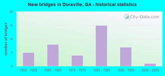
- New bridges - historical statistics
- 51950-1959
- 81960-1969
- 41970-1979
- 151980-1989
- 71990-1999
- 12000-2009

- Reconstructed bridges - Historical Statistics
- 71980-1989
- 21990-1999


- Bridge Condition - Deck
- 10.0%Very good
- 73.3%Good
- 16.7%Satisfactory

- Bridge Condition - Superstructure
- 20.0%Very good
- 63.3%Good
- 10.0%Satisfactory
- 3.3%Fair
- 3.3%Poor

- Bridge Condition - Substructure
- 13.3%Very good
- 60.0%Good
- 26.7%Satisfactory

- Bridge Condition - Channel
- 23.5%Very good
- 35.3%Good
- 41.2%Satisfactory

- Bridge Condition - Culverts
- 90.0%Good
- 10.0%Satisfactory
Find on map >> Show street view
Structure Number: 890037, Location: 1.6 MI N OF DORAVILLE (Lat: 33.924022, Lng: -84.280356), Route carried "on" structure: State highway 141, Year Built: 1969, Status: Open, Structure Length: 0.82m (2.69ft), Average Daily Traffic: 91,120 (year 2011), Truck Traffic: 1%, Average Future Daily Traffic: 136,680 (year 2031), Design Load: HS 20+Mod, Features Intersected: NANCY CREEK TRIB, Facility Carried by Structure: P'TREE IND. BLVD.
Minimum Vertical Clearance: 30+ m (98+ ft), Kilometerpoint: 9.656, Lanes on structure: 12, Base Highway Network: Yes, Owner: State Highway Agency, Approaching Roadway Width: 32.9m (107.9ft), Skew: 31 degrees, Material/Design: Concrete, Design/Construction: Culvert, Number Of Spans In Main Unit: 3, Length of Maximum Span: 2.4m (7.9ft)
Condition: Channel: Very good, Culverts: Good, Structural Evaluation: Better than present minimum criteria, Waterway Adequacy: Equal to present minimum criteria, Approach Roadway Alignment: Equal to present desirable criteria, Designated Inspection Frequency: Every 24 months, Inspection Date: August 2020, Bridge Improvement Cost: $393,000, Roadway Improvement Cost: $39,000, Total Project Cost: $590,000
Find on map >> Show street view
Structure Number: 890066, Location: 1.3 MI SE OF DORAVILLE (Lat: 33.904856, Lng: -84.237839), Route carried "on" structure: Interstate 85, Year Built: 1957, Year Reconstructed: 1985, Status: Open, Structure Length: 0.76m (2.49ft), Average Daily Traffic: 294,370 (year 2011), Truck Traffic: 1%, Average Future Daily Traffic: 441,555 (year 2031), Design Load: HS 20+Mod, Features Intersected: N FORK PEACHTREE CREEK
Minimum Vertical Clearance: 30+ m (98+ ft), Kilometerpoint: 156.106, Lanes on structure: 12, Base Highway Network: Yes, Owner: State Highway Agency, Approaching Roadway Width: 57.3m (188.0ft), Skew: 30 degrees, Material/Design: Concrete, Design/Construction: Culvert, Number Of Spans In Main Unit: 2, Length of Maximum Span: 3.0m (9.8ft)
Condition: Channel: Good, Culverts: Satisfactory, Structural Evaluation: Equal to present minimum criteria, Waterway Adequacy: Superior to present desirable criteria, Approach Roadway Alignment: Equal to present desirable criteria, Designated Inspection Frequency: Every 24 months, Inspection Date: August 2020, Bridge Improvement Cost: $364,000, Roadway Improvement Cost: $36,000, Total Project Cost: $546,000
Find on map >> Show street view
Structure Number: 89007, Location: 2.2 MI E OF DORAVILLE (Lat: 33.904125, Lng: -84.239142), Route carried "on" structure: Ramp Interstate 85, Year Built: 1980, Status: Open, Structure Length: 8.41m (27.59ft), Average Daily Traffic: 17,400 (year 2011), Truck Traffic: 1%, Average Future Daily Traffic: 26,100 (year 2031), Design Load: HS 20+Mod, Features Intersected: I-85- N FORK P'TREE CRK
Minimum Vertical Clearance: 30+ m (98+ ft), Kilometerpoint: 156.106, Lanes on structure: 3, Lanes under structure: 14, Base Highway Network: Yes, Owner: State Highway Agency, Approaching Roadway Width: 12.2m (40.0ft), Material/Design: Steel continuous, Design/Construction: Stringer/Multi-beam, Number Of Spans In Main Unit: 3, Length of Maximum Span: 33.8m (110.9ft), Curb or Sidewalk Widths: Left: 1.8m (5.9ft), Right: 1.8m (5.9ft), Curb-To-Curb Width: 12.2m (40.0ft), Out-to-Out Width: 16.6m (54.5ft)
Condition: Deck: Good, Superstructure: Good, Substructure: Good, Channel: Very good, Operating Rating: 39.0 metric tons, Method Used To Determine Operating Rating: Load Factor (LF), Inventory Rating: 23.5 metric tons, Method Used To Determine Inventory Rating: Load Factor (LF), Structural Evaluation: Somewhat better than minimum adequacy, Deck Geometry: High priority of corrective action, Underclear: High priority of corrective action, Waterway Adequacy: Equal to present desirable criteria, Approach Roadway Alignment: Equal to present desirable criteria, Designated Inspection Frequency: Every 24 months, Inspection Date: August 2020, Bridge Improvement Cost: $1,372,000, Roadway Improvement Cost: $137,000, Total Project Cost: $2,059,000, Deck Structure Type: Concrete Cast-file-Place, Wearing Surface/Protective System: Deck Protection: Epoxy Coated Reinforcing
Find on map >> Show street view
Structure Number: 890075, Location: IN DORAVILLE (Lat: 33.912847, Lng: -84.286347), Route carried "on" structure: Interstate 285, Year Built: 1961, Year Reconstructed: 1994, Status: Open, Structure Length: 5.91m (19.39ft), Average Daily Traffic: 239,000 (year 2011), Truck Traffic: 1%, Average Future Daily Traffic: 358,500 (year 2031), Design Load: HS 20+Mod, Features Intersected: SR 141 P'TREE IND. BLVD.
Minimum Vertical Clearance: 30+ m (98+ ft), Kilometerpoint: 48.280, Lanes on structure: 12, Lanes under structure: 7, Base Highway Network: Yes, Owner: State Highway Agency, Approaching Roadway Width: 56.7m (186.0ft), Skew: 31 degrees, Material/Design: Steel continuous, Design/Construction: Stringer/Multi-beam, Number Of Spans In Main Unit: 4, Length of Maximum Span: 17.7m (58.1ft), Curb-To-Curb Width: 56.8m (186.4ft), Out-to-Out Width: 67.4m (221.1ft)
Condition: Deck: Satisfactory, Superstructure: Satisfactory, Substructure: Satisfactory, Operating Rating: 60.7 metric tons, Method Used To Determine Operating Rating: Load Factor (LF), Inventory Rating: 36.2 metric tons, Method Used To Determine Inventory Rating: Load Factor (LF), Structural Evaluation: Equal to present minimum criteria, Deck Geometry: Superior to present desirable criteria, Underclear: High priority of corrective action, Approach Roadway Alignment: Equal to present desirable criteria, Designated Inspection Frequency: Every 24 months, Inspection Date: August 2020, Bridge Improvement Cost: $2,825,000, Roadway Improvement Cost: $283,000, Total Project Cost: $4,238,000, Deck Structure Type: Concrete Cast-file-Place
Find on map >> Show street view
Structure Number: 890076, Location: IN DORAVILLE (Lat: 33.902925, Lng: -84.273978), Route carried "on" structure: Interstate 285, Year Built: 1958, Year Reconstructed: 1995, Status: Open, Structure Length: 6.49m (21.29ft), Average Daily Traffic: 233,470 (year 2011), Truck Traffic: 1%, Average Future Daily Traffic: 350,205 (year 2031), Design Load: HS 20+Mod, Features Intersected: SR 13 BUFORD HIGHWAY
Minimum Vertical Clearance: 30+ m (98+ ft), Kilometerpoint: 51.499, Lanes on structure: 13, Lanes under structure: 8, Base Highway Network: Yes, Owner: State Highway Agency, Approaching Roadway Width: 50.3m (165.0ft), Skew: 31 degrees, Material/Design: Steel continuous, Design/Construction: Stringer/Multi-beam, Number Of Spans In Main Unit: 4, Length of Maximum Span: 22.9m (75.1ft), Curb-To-Curb Width: 50.6m (166.0ft), Out-to-Out Width: 53.1m (174.2ft)
Condition: Deck: Good, Superstructure: Good, Substructure: Good, Operating Rating: 60.7 metric tons, Method Used To Determine Operating Rating: Load Factor (LF), Inventory Rating: 36.2 metric tons, Method Used To Determine Inventory Rating: Load Factor (LF), Structural Evaluation: Better than present minimum criteria, Deck Geometry: Meets minimum limits, Underclear: Meets minimum limits, Approach Roadway Alignment: Equal to present desirable criteria, Designated Inspection Frequency: Every 24 months, Inspection Date: August 2020, Bridge Improvement Cost: $3,329,000, Roadway Improvement Cost: $333,000, Total Project Cost: $4,993,000, Deck Structure Type: Concrete Cast-file-Place, Wearing Surface/Protective System: Wearing Surface: Epoxy Overlay
Find on map >> Show street view
Structure Number: 890077, Location: 2.4 MI E OF CHAMBLEE (Lat: 33.891842, Lng: -84.259211), Route carried "on" structure: Interstate 285, Year Built: 1968, Year Reconstructed: 1985, Status: Open, Structure Length: 8.02m (26.31ft), Average Daily Traffic: 173,399 (year 2011), Truck Traffic: 1%, Average Future Daily Traffic: 260,099 (year 2031), Design Load: HS 20+Mod, Features Intersected: I-85- I-85 RAMP
Minimum Vertical Clearance: 30+ m (98+ ft), Kilometerpoint: 53.108, Lanes on structure: 7, Lanes under structure: 11, Base Highway Network: Yes, Owner: State Highway Agency, Approaching Roadway Width: 31.7m (104.0ft), Skew: 31 degrees, Material/Design: Steel continuous, Design/Construction: Stringer/Multi-beam, Number Of Spans In Main Unit: 4, Length of Maximum Span: 22.3m (73.2ft), Curb-To-Curb Width: 44.2m (145.0ft), Out-to-Out Width: 45.2m (148.3ft)
Condition: Deck: Good, Superstructure: Good, Substructure: Satisfactory, Operating Rating: 33.5 metric tons, Method Used To Determine Operating Rating: Load Factor (LF), Inventory Rating: 19.9 metric tons, Method Used To Determine Inventory Rating: Load Factor (LF), Structural Evaluation: Somewhat better than minimum adequacy, Deck Geometry: Superior to present desirable criteria, Underclear: High priority of corrective action, Approach Roadway Alignment: Equal to present desirable criteria, Designated Inspection Frequency: Every 24 months, Inspection Date: July 2020, Bridge Improvement Cost: $2,429,000, Roadway Improvement Cost: $243,000, Total Project Cost: $3,643,000, Deck Structure Type: Concrete Cast-file-Place
Find on map >> Show street view
Structure Number: 890078, Location: IN I-285/I-85 INT-CHANGE (Lat: 33.889672, Lng: -84.257847), Route carried "on" structure: Interstate 285, Year Built: 1959, Year Reconstructed: 1985, Status: Open, Structure Length: 1.68m (5.51ft), Average Daily Traffic: 116,740 (year 2011), Truck Traffic: 1%, Average Future Daily Traffic: 175,110 (year 2031), Design Load: HS 20+Mod, Features Intersected: N FORK PEACHTREE CREEK
Minimum Vertical Clearance: 30+ m (98+ ft), Kilometerpoint: 53.108, Lanes on structure: 7, Base Highway Network: Yes, Owner: State Highway Agency, Approaching Roadway Width: 31.7m (104.0ft), Skew: 39 degrees, Material/Design: Concrete, Design/Construction: Culvert, Number Of Spans In Main Unit: 5, Length of Maximum Span: 3.0m (9.8ft)
Condition: Channel: Good, Culverts: Good, Structural Evaluation: Better than present minimum criteria, Waterway Adequacy: Equal to present desirable criteria, Approach Roadway Alignment: Equal to present desirable criteria, Designated Inspection Frequency: Every 24 months, Inspection Date: August 2020, Bridge Improvement Cost: $508,000, Roadway Improvement Cost: $51,000, Total Project Cost: $762,000
Find on map >> Show street view
Structure Number: 890198, Location: 1.8 MI S OF CHAMBLEE (Lat: 33.878553, Lng: -84.268653), Route carried "on" structure: City street 9265, Year Built: 1998, Status: Open, Structure Length: 1.62m (5.31ft), Average Daily Traffic: 13,070 (year 2011), Truck Traffic: 1%, Average Future Daily Traffic: 19,605 (year 2031), Design Load: H 15, Features Intersected: N FORK PEACHTREE CREEK, Facility Carried by Structure: CHAM.-TUCKER ROAD
Minimum Vertical Clearance: 30+ m (98+ ft), Kilometerpoint: 3.219, Lanes on structure: 7, Base Highway Network: Yes, Owner: County Highway Agency, Approaching Roadway Width: 29.9m (98.1ft), Skew: 20 degrees, Material/Design: Concrete, Design/Construction: Culvert, Number Of Spans In Main Unit: 4, Length of Maximum Span: 3.0m (9.8ft)
Condition: Channel: Satisfactory, Culverts: Good, Operating Rating: 43.5 metric tons, Method Used To Determine Operating Rating: Field evaluation and documented engineering judgment, Inventory Rating: 24.4 metric tons, Method Used To Determine Inventory Rating: Field evaluation and documented engineering judgment, Structural Evaluation: Equal to present minimum criteria, Waterway Adequacy: Equal to present minimum criteria, Approach Roadway Alignment: Equal to present minimum criteria, Designated Inspection Frequency: Every 24 months, Inspection Date: July 2020, Bridge Improvement Cost: $489,000, Roadway Improvement Cost: $49,000, Total Project Cost: $734,000
Find on map >> Show street view
Structure Number: 890204, Location: IN DORAVILLE (Lat: 33.904419, Lng: -84.276778), Route carried "on" structure: City street 9267, Year Built: 1977, Status: Open, Structure Length: 10.03m (32.91ft), Average Daily Traffic: 12,180 (year 2011), Truck Traffic: 1%, Average Future Daily Traffic: 18,270 (year 2031), Design Load: HS 20+Mod, Features Intersected: SR 13 CONN- I-285, Facility Carried by Structure: NEW P'TREE ROAD
Minimum Vertical Clearance: 30+ m (98+ ft), Kilometerpoint: 8.047, Lanes on structure: 4, Lanes under structure: 18, Base Highway Network: Yes, Owner: State Highway Agency, Approaching Roadway Width: 12.2m (40.0ft), Skew: 1 degrees, Material/Design: Steel, Design/Construction: Stringer/Multi-beam, Number Of Spans In Main Unit: 4, Length of Maximum Span: 33.8m (110.9ft), Curb or Sidewalk Widths: Left: 1.8m (5.9ft), Right: 1.8m (5.9ft), Curb-To-Curb Width: 15.8m (51.8ft), Out-to-Out Width: 20.2m (66.3ft)
Condition: Deck: Good, Superstructure: Very good, Substructure: Good, Operating Rating: 42.6 metric tons, Method Used To Determine Operating Rating: Load Factor (LF), Inventory Rating: 25.4 metric tons, Method Used To Determine Inventory Rating: Load Factor (LF), Structural Evaluation: Equal to present minimum criteria, Deck Geometry: Meets minimum limits, Underclear: Somewhat better than minimum adequacy, Approach Roadway Alignment: Better than present minimum criteria, Designated Inspection Frequency: Every 24 months, Inspection Date: August 2020, Bridge Improvement Cost: $1,987,000, Roadway Improvement Cost: $199,000, Total Project Cost: $2,980,000, Deck Structure Type: Concrete Cast-file-Place, Wearing Surface/Protective System: Deck Protection: Epoxy Coated Reinforcing
Find on map >> Show street view
Structure Number: 890205, Location: 1.5 MI N OF DORAVILLE (Lat: 33.923956, Lng: -84.281886), Route carried "on" structure: City street 9269, Year Built: 1977, Year Reconstructed: 1991, Status: Open, Structure Length: 1.89m (6.20ft), Average Daily Traffic: 5,210 (year 2011), Truck Traffic: 1%, Average Future Daily Traffic: 7,815 (year 2031), Design Load: H 15, Features Intersected: NANCY CREEK, Facility Carried by Structure: TILLY MILL ROAD
Minimum Vertical Clearance: 30+ m (98+ ft), Kilometerpoint: 1.609, Lanes on structure: 4, Base Highway Network: Yes, Owner: County Highway Agency, Approaching Roadway Width: 15.2m (49.9ft), Material/Design: Concrete, Design/Construction: Tee Beam, Number Of Spans In Main Unit: 2, Length of Maximum Span: 9.4m (30.8ft), Curb or Sidewalk Widths: Left: 1.8m (5.9ft), Right: 1.8m (5.9ft), Curb-To-Curb Width: 20.3m (66.6ft), Out-to-Out Width: 24.7m (81.0ft)
Condition: Deck: Satisfactory, Superstructure: Good, Substructure: Satisfactory, Channel: Good, Operating Rating: 34.4 metric tons, Method Used To Determine Operating Rating: Allowable Stress (AS), Inventory Rating: 21.7 metric tons, Method Used To Determine Inventory Rating: Allowable Stress (AS), Structural Evaluation: Somewhat better than minimum adequacy, Deck Geometry: Equal to present desirable criteria, Waterway Adequacy: Meets minimum limits, Approach Roadway Alignment: Better than present minimum criteria, Designated Inspection Frequency: Every 24 months, Inspection Date: August 2020, Bridge Improvement Cost: $374,000, Roadway Improvement Cost: $37,000, Total Project Cost: $562,000, Deck Structure Type: Concrete Cast-file-Place
Find on map >> Show street view
Structure Number: 890206, Location: 2.1 MI SE OF DORAVILLE (Lat: 33.897278, Lng: -84.242669), Route carried "on" structure: City street 9271, Year Built: 1960, Year Reconstructed: 1990, Status: Open, Structure Length: 0.98m (3.22ft), Average Daily Traffic: 22,670 (year 2011), Truck Traffic: 3%, Average Future Daily Traffic: 34,005 (year 2031), Design Load: HS 20, Features Intersected: N FORK PEACHTREE CREEK, Facility Carried by Structure: PLEASANTDALE ROAD
Minimum Vertical Clearance: 30+ m (98+ ft), Kilometerpoint: 6.437, Lanes on structure: 5, Base Highway Network: Yes, Owner: County Highway Agency, Approaching Roadway Width: 19.5m (64.0ft), Material/Design: Concrete, Design/Construction: Culvert, Number Of Spans In Main Unit: 3, Length of Maximum Span: 3.0m (9.8ft)
Condition: Channel: Satisfactory, Culverts: Good, Operating Rating: 55.3 metric tons, Method Used To Determine Operating Rating: Field evaluation and documented engineering judgment, Inventory Rating: 32.6 metric tons, Method Used To Determine Inventory Rating: Field evaluation and documented engineering judgment, Structural Evaluation: Better than present minimum criteria, Waterway Adequacy: Equal to present desirable criteria, Approach Roadway Alignment: Equal to present minimum criteria, Designated Inspection Frequency: Every 24 months, Inspection Date: August 2020, Bridge Improvement Cost: $227,000, Roadway Improvement Cost: $23,000, Total Project Cost: $341,000
Find on map >> Show street view
Structure Number: 890207, Location: 2 MI E OF DORAVILLE (Lat: 33.901153, Lng: -84.244094), Route carried "on" structure: City street 9271, Year Built: 1985, Status: Open, Structure Length: 7.38m (24.21ft), Average Daily Traffic: 22,670 (year 2011), Truck Traffic: 3%, Average Future Daily Traffic: 34,005 (year 2031), Design Load: HS 20+Mod, Features Intersected: I-85, Facility Carried by Structure: PLEASANTDALE ROAD
Minimum Vertical Clearance: 30+ m (98+ ft), Kilometerpoint: 6.437, Lanes on structure: 6, Lanes under structure: 14, Base Highway Network: Yes, Owner: State Highway Agency, Approaching Roadway Width: 24.4m (80.1ft), Skew: 21 degrees, Material/Design: Steel continuous, Design/Construction: Stringer/Multi-beam, Number Of Spans In Main Unit: 2, Length of Maximum Span: 36.9m (121.1ft), Curb or Sidewalk Widths: Left: 2.1m (6.9ft), Right: 2.1m (6.9ft), Curb-To-Curb Width: 24.4m (80.1ft), Out-to-Out Width: 29.4m (96.5ft)
Condition: Deck: Good, Superstructure: Good, Substructure: Good, Operating Rating: 46.2 metric tons, Method Used To Determine Operating Rating: Allowable Stress (AS), Inventory Rating: 32.6 metric tons, Method Used To Determine Inventory Rating: Allowable Stress (AS), Structural Evaluation: Better than present minimum criteria, Deck Geometry: Somewhat better than minimum adequacy, Underclear: High priority of corrective action, Approach Roadway Alignment: Equal to present desirable criteria, Designated Inspection Frequency: Every 24 months, Inspection Date: August 2020, Bridge Improvement Cost: $1,977,000, Roadway Improvement Cost: $198,000, Total Project Cost: $2,966,000, Deck Structure Type: Concrete Cast-file-Place, Wearing Surface/Protective System: Deck Protection: Epoxy Coated Reinforcing
Find on map >> Show street view
Structure Number: 890208, Location: 1.7 MI SE OF DORAVILLE (Lat: 33.893858, Lng: -84.250658), Route carried "on" structure: City street 9273, Year Built: 1958, Year Reconstructed: 1985, Status: Open, Structure Length: 1.16m (3.81ft), Average Daily Traffic: 9,200 (year 2011), Truck Traffic: 1%, Average Future Daily Traffic: 13,800 (year 2031), Design Load: H 15, Features Intersected: N FORK PEACHTREE CREEK, Facility Carried by Structure: NORTHCREST ROAD
Minimum Vertical Clearance: 30+ m (98+ ft), Kilometerpoint: 0.000, Lanes on structure: 5, Base Highway Network: Yes, Owner: State Highway Agency, Approaching Roadway Width: 8.5m (27.9ft), Skew: 9 degrees, Material/Design: Concrete, Design/Construction: Culvert, Number Of Spans In Main Unit: 3, Length of Maximum Span: 3.0m (9.8ft), Curb or Sidewalk Widths: Left: 1.8m (5.9ft), Right: 1.8m (5.9ft)
Condition: Channel: Satisfactory, Culverts: Good, Operating Rating: 43.5 metric tons, Method Used To Determine Operating Rating: Field evaluation and documented engineering judgment, Inventory Rating: 24.4 metric tons, Method Used To Determine Inventory Rating: Field evaluation and documented engineering judgment, Structural Evaluation: Equal to present minimum criteria, Waterway Adequacy: Equal to present desirable criteria, Approach Roadway Alignment: Better than present minimum criteria, Designated Inspection Frequency: Every 24 months, Inspection Date: August 2020, Bridge Improvement Cost: $270,000, Roadway Improvement Cost: $27,000, Total Project Cost: $405,000
Find on map >> Show street view
Structure Number: 890209, Location: 1.7 MI E OF DORAVILLE (Lat: 33.897142, Lng: -84.250714), Route carried "on" structure: City street 9273, Year Built: 1985, Status: Open, Structure Length: 12.74m (41.80ft), Average Daily Traffic: 13,960 (year 2011), Truck Traffic: 1%, Average Future Daily Traffic: 20,940 (year 2031), Design Load: HS 20+Mod, Features Intersected: I85- 3 I85 RMP- 2 I285 R, Facility Carried by Structure: NORTHCREST ROAD
Minimum Vertical Clearance: 30+ m (98+ ft), Kilometerpoint: 1.609, Lanes on structure: 6, Lanes under structure: 21, Base Highway Network: Yes, Owner: State Highway Agency, Approaching Roadway Width: 24.4m (80.1ft), Skew: 23 degrees, Material/Design: Steel, Design/Construction: Stringer/Multi-beam, Number Of Spans In Main Unit: 3, Length of Maximum Span: 55.8m (183.1ft), Curb or Sidewalk Widths: Left: 2.1m (6.9ft), Right: 2.1m (6.9ft), Curb-To-Curb Width: 24.4m (80.1ft), Out-to-Out Width: 29.4m (96.5ft)
Condition: Deck: Good, Superstructure: Satisfactory, Substructure: Satisfactory, Operating Rating: 39.9 metric tons, Method Used To Determine Operating Rating: Load Factor (LF), Inventory Rating: 23.5 metric tons, Method Used To Determine Inventory Rating: Load Factor (LF), Structural Evaluation: Somewhat better than minimum adequacy, Deck Geometry: Somewhat better than minimum adequacy, Underclear: High priority of corrective action, Approach Roadway Alignment: Equal to present desirable criteria, Designated Inspection Frequency: Every 24 months, Inspection Date: August 2020, Bridge Improvement Cost: $3,415,000, Roadway Improvement Cost: $341,000, Total Project Cost: $5,122,000, Deck Structure Type: Concrete Cast-file-Place, Wearing Surface/Protective System: Deck Protection: Epoxy Coated Reinforcing
Find on map >> Show street view
Structure Number: 89021, Location: 2 MI S OF DORAVILLE (Lat: 33.876919, Lng: -84.267000), Route carried "on" structure: City street 9275, Year Built: 1967, Status: Posted for load, Structure Length: 3.05m (10.01ft), Average Daily Traffic: 16,550 (year 2011), Truck Traffic: 1%, Average Future Daily Traffic: 24,825 (year 2031), Design Load: H 10, Features Intersected: N FORK PEACHTREE CREEK, Facility Carried by Structure: MERCER UNIV. DRIVE
Minimum Vertical Clearance: 30+ m (98+ ft), Kilometerpoint: 0.000, Lanes on structure: 2, Base Highway Network: Yes, Owner: City or Municipal Highway Agency, Approaching Roadway Width: 9.1m (29.9ft), Material/Design: Steel continuous, Design/Construction: Stringer/Multi-beam, Number Of Spans In Main Unit: 4, Length of Maximum Span: 7.6m (24.9ft), Curb or Sidewalk Widths: Left: 0.9m (3.0ft), Right: 0.9m (3.0ft), Curb-To-Curb Width: 9.1m (29.9ft), Out-to-Out Width: 11.0m (36.1ft)
Condition: Deck: Satisfactory, Superstructure: Fair, Substructure: Good, Channel: Satisfactory, Operating Rating: 9.0 metric tons, Method Used To Determine Operating Rating: Load Factor (LF), Inventory Rating: 5.4 metric tons, Method Used To Determine Inventory Rating: Load Factor (LF), Structural Evaluation: High priority of replacement, Deck Geometry: High priority of corrective action, Waterway Adequacy: Equal to present minimum criteria, Approach Roadway Alignment: Better than present minimum criteria, Bridge Posting: Required (Relationship of Operating Rating to Maximum Legal Load: > 39.9% below), Length Of Structure Improvement: 9.48m (31.10ft), Designated Inspection Frequency: Every 24 months, Inspection Date: July 2020, Bridge Improvement Cost: $391,000, Roadway Improvement Cost: $39,000, Total Project Cost: $586,000, Deck Structure Type: Concrete Cast-file-Place
Find on map >> Show street view
Structure Number: 890212, Location: 2.3 MI E OF DORAVILLE (Lat: 33.902858, Lng: -84.240447), Route carried "on" structure: City street 9278, Year Built: 1957, Year Reconstructed: 1985, Status: Open, Structure Length: 0.88m (2.89ft), Average Daily Traffic: 8,550 (year 2011), Truck Traffic: 1%, Average Future Daily Traffic: 12,825 (year 2031), Design Load: H 15, Features Intersected: N FORK PEACHTREE CREEK, Facility Carried by Structure: ACCESS ROAD
Minimum Vertical Clearance: 30+ m (98+ ft), Kilometerpoint: 1.609, Lanes on structure: 2, Base Highway Network: Yes, Owner: State Highway Agency, Approaching Roadway Width: 8.5m (27.9ft), Skew: 4 degrees, Material/Design: Concrete, Design/Construction: Culvert, Number Of Spans In Main Unit: 2, Length of Maximum Span: 4.3m (14.1ft)
Condition: Channel: Good, Culverts: Good, Operating Rating: 59.8 metric tons, Method Used To Determine Operating Rating: Load Factor (LF), Inventory Rating: 36.2 metric tons, Method Used To Determine Inventory Rating: Load Factor (LF), Structural Evaluation: Better than present minimum criteria, Waterway Adequacy: Equal to present minimum criteria, Approach Roadway Alignment: Equal to present minimum criteria, Designated Inspection Frequency: Every 24 months, Inspection Date: August 2020, Bridge Improvement Cost: $113,000, Roadway Improvement Cost: $11,000, Total Project Cost: $170,000
Find on map >> Show street view
Structure Number: 890269, Location: 2.4 MI E OF CHAMBLEE (Lat: 33.891417, Lng: -84.260075), Route carried "on" structure: Ramp Interstate 85, Year Built: 1985, Status: Open, Structure Length: 52.85m (173.39ft), Average Daily Traffic: 2,202 (year 2011), Truck Traffic: 1%, Average Future Daily Traffic: 3,303 (year 2031), Design Load: HS 20+Mod, Features Intersected: I-85- I-285- 4 RAMPS
Minimum Vertical Clearance: 5.53m (18.14ft), Kilometerpoint: 152.888, Lanes on structure: 2, Lanes under structure: 19, Base Highway Network: Yes, Owner: State Highway Agency, Approaching Roadway Width: 11.6m (38.1ft), Material/Design: Prestressed concrete continuous, Design/Construction: Box Beam or Girders - Single/Spread, Number Of Spans In Main Unit: 9, Length of Maximum Span: 68.9m (226.0ft), Curb-To-Curb Width: 12.8m (42.0ft), Out-to-Out Width: 13.8m (45.3ft)
Condition: Deck: Good, Superstructure: Good, Substructure: Good, Operating Rating: 55.3 metric tons, Method Used To Determine Operating Rating: Load Factor (LF), Inventory Rating: 32.6 metric tons, Method Used To Determine Inventory Rating: Load Factor (LF), Structural Evaluation: Better than present minimum criteria, Deck Geometry: Superior to present desirable criteria, Underclear: High priority of corrective action, Approach Roadway Alignment: Equal to present desirable criteria, Designated Inspection Frequency: Every 24 months, Inspection Date: August 2020, Bridge Improvement Cost: $6,775,000, Roadway Improvement Cost: $678,000, Total Project Cost: $10,163,000, Deck Structure Type: Concrete Cast-file-Place, Wearing Surface/Protective System: Wearing Surface: Epoxy Overlay, Deck Protection: Epoxy Coated Reinforcing
Find on map >> Show street view
Structure Number: 89027, Location: 2.7 MI E OF CHAMBLEE (Lat: 33.889864, Lng: -84.258067), Route carried "on" structure: Ramp Interstate 85, Year Built: 1985, Status: Open, Structure Length: 9.24m (30.31ft), Average Daily Traffic: 33,360 (year 2011), Truck Traffic: 1%, Average Future Daily Traffic: 50,040 (year 2031), Design Load: HS 20+Mod, Features Intersected: SR407(US 23RMP TO M9265)
Minimum Vertical Clearance: 30+ m (98+ ft), Kilometerpoint: 152.888, Lanes on structure: 2, Lanes under structure: 1, Base Highway Network: Yes, Owner: State Highway Agency, Approaching Roadway Width: 12.2m (40.0ft), Material/Design: Prestressed concrete continuous, Design/Construction: Box Beam or Girders - Single/Spread, Number Of Spans In Main Unit: 3, Length of Maximum Span: 39.0m (128.0ft), Curb-To-Curb Width: 12.8m (42.0ft), Out-to-Out Width: 13.8m (45.3ft)
Condition: Deck: Very good, Superstructure: Good, Substructure: Good, Operating Rating: 60.7 metric tons, Method Used To Determine Operating Rating: Load Factor (LF), Inventory Rating: 36.2 metric tons, Method Used To Determine Inventory Rating: Load Factor (LF), Structural Evaluation: Better than present minimum criteria, Deck Geometry: Superior to present desirable criteria, Underclear: Superior to present desirable criteria, Approach Roadway Alignment: Equal to present desirable criteria, Designated Inspection Frequency: Every 24 months, Inspection Date: August 2020, Bridge Improvement Cost: $1,184,000, Roadway Improvement Cost: $118,000, Total Project Cost: $1,776,000, Deck Structure Type: Concrete Cast-file-Place, Wearing Surface/Protective System: Wearing Surface: Epoxy Overlay
Find on map >> Show street view
Structure Number: 890271, Location: 2.5 MI E OF CHAMBLEE (Lat: 33.892553, Lng: -84.256819), Route carried "on" structure: Ramp Interstate 85, Year Built: 1985, Status: Open, Structure Length: 4.30m (14.11ft), Average Daily Traffic: 10,530 (year 2011), Truck Traffic: 1%, Average Future Daily Traffic: 15,795 (year 2031), Design Load: HS 20+Mod, Features Intersected: I-285 RMP CB TO I-85 NB
Minimum Vertical Clearance: 30+ m (98+ ft), Kilometerpoint: 154.497, Lanes on structure: 1, Lanes under structure: 2, Base Highway Network: Yes, Owner: State Highway Agency, Approaching Roadway Width: 8.5m (27.9ft), Material/Design: Prestressed concrete, Design/Construction: Box Beam or Girders - Single/Spread, Number Of Spans In Main Unit: 1, Length of Maximum Span: 43.0m (141.1ft), Curb-To-Curb Width: 9.1m (29.9ft), Out-to-Out Width: 10.1m (33.1ft)
Condition: Deck: Good, Superstructure: Good, Substructure: Satisfactory, Operating Rating: 55.3 metric tons, Method Used To Determine Operating Rating: Load Factor (LF), Inventory Rating: 32.6 metric tons, Method Used To Determine Inventory Rating: Load Factor (LF), Structural Evaluation: Equal to present minimum criteria, Deck Geometry: Superior to present desirable criteria, Underclear: Superior to present desirable criteria, Approach Roadway Alignment: Equal to present desirable criteria, Designated Inspection Frequency: Every 24 months, Inspection Date: August 2020, Bridge Improvement Cost: $401,000, Roadway Improvement Cost: $40,000, Total Project Cost: $601,000, Deck Structure Type: Concrete Cast-file-Place, Wearing Surface/Protective System: Wearing Surface: Epoxy Overlay
Find on map >> Show street view
Structure Number: 890272, Location: 2.4 MI E OF CHAMBLEE (Lat: 33.893161, Lng: -84.260675), Route carried "on" structure: Ramp Interstate 85, Year Built: 1986, Status: Open, Structure Length: 50.17m (164.60ft), Average Daily Traffic: 17,690 (year 2011), Truck Traffic: 1%, Average Future Daily Traffic: 26,535 (year 2031), Design Load: HS 20+Mod, Features Intersected: 3 I-85 RMPS-2 I-285 RMPS
Minimum Vertical Clearance: 30+ m (98+ ft), Kilometerpoint: 154.497, Lanes on structure: 1, Lanes under structure: 9, Base Highway Network: Yes, Owner: State Highway Agency, Approaching Roadway Width: 8.8m (28.9ft), Material/Design: Prestressed concrete continuous, Design/Construction: Box Beam or Girders - Single/Spread, Number Of Spans In Main Unit: 13, Length of Maximum Span: 50.3m (165.0ft), Curb-To-Curb Width: 9.1m (29.9ft), Out-to-Out Width: 10.1m (33.1ft)
Condition: Deck: Good, Superstructure: Good, Substructure: Good, Operating Rating: 46.2 metric tons, Method Used To Determine Operating Rating: Allowable Stress (AS), Inventory Rating: 32.6 metric tons, Method Used To Determine Inventory Rating: Allowable Stress (AS), Structural Evaluation: Better than present minimum criteria, Deck Geometry: Superior to present desirable criteria, Underclear: Better than present minimum criteria, Approach Roadway Alignment: Equal to present desirable criteria, Designated Inspection Frequency: Every 24 months, Inspection Date: August 2020, Bridge Improvement Cost: $4,677,000, Roadway Improvement Cost: $468,000, Total Project Cost: $7,016,000, Deck Structure Type: Concrete Cast-file-Place, Wearing Surface/Protective System: Wearing Surface: Epoxy Overlay, Deck Protection: Epoxy Coated Reinforcing
Find on map >> Show street view
Structure Number: 890273, Location: 2.3 MI E OF CHAMBLEE (Lat: 33.891447, Lng: -84.258200), Route carried "on" structure: Ramp Interstate 85, Year Built: 1987, Status: Open, Structure Length: 47.91m (157.19ft), Average Daily Traffic: 29,750 (year 2011), Truck Traffic: 1%, Average Future Daily Traffic: 44,625 (year 2031), Design Load: HS 20+Mod, Features Intersected: I-85- I-285- 2 RAMPS
Minimum Vertical Clearance: 5.15m (16.90ft), Kilometerpoint: 154.497, Lanes on structure: 2, Lanes under structure: 17, Base Highway Network: Yes, Owner: State Highway Agency, Approaching Roadway Width: 11.6m (38.1ft), Material/Design: Prestressed concrete continuous, Design/Construction: Box Beam or Girders - Single/Spread, Number Of Spans In Main Unit: 9, Length of Maximum Span: 65.5m (214.9ft), Curb-To-Curb Width: 12.8m (42.0ft), Out-to-Out Width: 13.8m (45.3ft)
Condition: Deck: Good, Superstructure: Good, Substructure: Good, Operating Rating: 65.3 metric tons, Method Used To Determine Operating Rating: Load Factor (LF), Inventory Rating: 39.0 metric tons, Method Used To Determine Inventory Rating: Load Factor (LF), Structural Evaluation: Better than present minimum criteria, Deck Geometry: Superior to present desirable criteria, Underclear: High priority of corrective action, Approach Roadway Alignment: Equal to present desirable criteria, Designated Inspection Frequency: Every 24 months, Inspection Date: August 2020, Bridge Improvement Cost: $6,142,000, Roadway Improvement Cost: $614,000, Total Project Cost: $9,213,000, Deck Structure Type: Concrete Cast-file-Place, Wearing Surface/Protective System: Wearing Surface: Epoxy Overlay, Deck Protection: Epoxy Coated Reinforcing
Find on map >> Show street view
Structure Number: 890274, Location: 2.8 MI E OF CHAMBLEE (Lat: 33.894186, Lng: -84.256794), Route carried "on" structure: Ramp Interstate 85, Year Built: 1987, Status: Open, Structure Length: 16.00m (52.49ft), Average Daily Traffic: 2,202 (year 2011), Truck Traffic: 1%, Average Future Daily Traffic: 3,303 (year 2031), Design Load: HS 20+Mod, Features Intersected: I-85 RMP SB TO I-285 CCB
Minimum Vertical Clearance: 30+ m (98+ ft), Kilometerpoint: 154.497, Lanes on structure: 1, Lanes under structure: 3, Base Highway Network: Yes, Owner: State Highway Agency, Approaching Roadway Width: 8.8m (28.9ft), Material/Design: Prestressed concrete continuous, Design/Construction: Box Beam or Girders - Single/Spread, Number Of Spans In Main Unit: 4, Length of Maximum Span: 52.7m (172.9ft), Curb-To-Curb Width: 9.1m (29.9ft), Out-to-Out Width: 10.1m (33.1ft)
Condition: Deck: Good, Superstructure: Good, Substructure: Good, Operating Rating: 55.3 metric tons, Method Used To Determine Operating Rating: Load Factor (LF), Inventory Rating: 32.6 metric tons, Method Used To Determine Inventory Rating: Load Factor (LF), Structural Evaluation: Better than present minimum criteria, Deck Geometry: Superior to present desirable criteria, Underclear: Superior to present desirable criteria, Approach Roadway Alignment: Equal to present desirable criteria, Designated Inspection Frequency: Every 24 months, Inspection Date: August 2020, Bridge Improvement Cost: $1,492,000, Roadway Improvement Cost: $149,000, Total Project Cost: $2,238,000, Deck Structure Type: Concrete Cast-file-Place, Wearing Surface/Protective System: Wearing Surface: Epoxy Overlay, Deck Protection: Epoxy Coated Reinforcing
Find on map >> Show street view
Structure Number: 890275, Location: 2.3 MI E OF CHAMBLEE (Lat: 33.894019, Lng: -84.263358), Route carried "on" structure: Ramp Interstate 285, Year Built: 1986, Status: Open, Structure Length: 9.45m (31.00ft), Average Daily Traffic: 22,920 (year 2011), Truck Traffic: 1%, Average Future Daily Traffic: 34,380 (year 2031), Design Load: HS 20+Mod, Features Intersected: I-285 RMP CB FROM US 23
Minimum Vertical Clearance: 30+ m (98+ ft), Kilometerpoint: 51.499, Lanes on structure: 2, Lanes under structure: 2, Base Highway Network: Yes, Owner: State Highway Agency, Approaching Roadway Width: 12.8m (42.0ft), Material/Design: Prestressed concrete continuous, Design/Construction: Box Beam or Girders - Single/Spread, Number Of Spans In Main Unit: 3, Length of Maximum Span: 41.5m (136.2ft), Curb-To-Curb Width: 12.8m (42.0ft), Out-to-Out Width: 13.8m (45.3ft)
Condition: Deck: Good, Superstructure: Good, Substructure: Good, Operating Rating: 46.2 metric tons, Method Used To Determine Operating Rating: Allowable Stress (AS), Inventory Rating: 32.6 metric tons, Method Used To Determine Inventory Rating: Allowable Stress (AS), Structural Evaluation: Better than present minimum criteria, Deck Geometry: Superior to present desirable criteria, Underclear: Superior to present desirable criteria, Approach Roadway Alignment: Equal to present desirable criteria, Designated Inspection Frequency: Every 24 months, Inspection Date: August 2020, Bridge Improvement Cost: $1,211,000, Roadway Improvement Cost: $121,000, Total Project Cost: $1,817,000, Deck Structure Type: Concrete Cast-file-Place, Wearing Surface/Protective System: Wearing Surface: Epoxy Overlay
Find on map >> Show street view
Structure Number: 890276, Location: 2.4 MI E OF CHAMBLEE (Lat: 33.892294, Lng: -84.259236), Route carried "on" structure: Ramp Interstate 285, Year Built: 1987, Status: Open, Structure Length: 72.33m (237.30ft), Average Daily Traffic: 40,290 (year 2011), Truck Traffic: 1%, Average Future Daily Traffic: 60,435 (year 2031), Design Load: HS 20+Mod, Features Intersected: 2 I-85 RMPS-4 I-285 RMPS
Minimum Vertical Clearance: 6.37m (20.90ft), Kilometerpoint: 51.499, Lanes on structure: 2, Lanes under structure: 11, Base Highway Network: Yes, Owner: State Highway Agency, Approaching Roadway Width: 11.9m (39.0ft), Material/Design: Prestressed concrete continuous, Design/Construction: Box Beam or Girders - Single/Spread, Number Of Spans In Main Unit: 14, Length of Maximum Span: 69.2m (227.0ft), Curb-To-Curb Width: 12.8m (42.0ft), Out-to-Out Width: 13.8m (45.3ft)
Condition: Deck: Good, Superstructure: Good, Substructure: Good, Operating Rating: 55.3 metric tons, Method Used To Determine Operating Rating: Load Factor (LF), Inventory Rating: 32.6 metric tons, Method Used To Determine Inventory Rating: Load Factor (LF), Structural Evaluation: Better than present minimum criteria, Deck Geometry: Superior to present desirable criteria, Underclear: Superior to present desirable criteria, Approach Roadway Alignment: Equal to present desirable criteria, Designated Inspection Frequency: Every 24 months, Inspection Date: August 2020, Bridge Improvement Cost: $9,272,000, Roadway Improvement Cost: $927,000, Total Project Cost: $13,908,000, Deck Structure Type: Concrete Cast-file-Place, Wearing Surface/Protective System: Wearing Surface: Epoxy Overlay, Deck Protection: Epoxy Coated Reinforcing
Find on map >> Show street view
Structure Number: 890277, Location: 2.3 MI E OF CHAMBLEE (Lat: 33.893478, Lng: -84.263194), Route carried "on" structure: Ramp Interstate 285, Year Built: 1987, Status: Open, Structure Length: 15.61m (51.21ft), Average Daily Traffic: 2,202 (year 2011), Truck Traffic: 1%, Average Future Daily Traffic: 3,303 (year 2031), Design Load: HS 20+Mod, Features Intersected: I-285 RMP CB TO I-85 SB
Minimum Vertical Clearance: 30+ m (98+ ft), Kilometerpoint: 51.499, Lanes on structure: 1, Lanes under structure: 2, Base Highway Network: Yes, Owner: State Highway Agency, Approaching Roadway Width: 8.5m (27.9ft), Material/Design: Prestressed concrete continuous, Design/Construction: Box Beam or Girders - Single/Spread, Number Of Spans In Main Unit: 3, Length of Maximum Span: 59.4m (194.9ft), Curb-To-Curb Width: 9.1m (29.9ft), Out-to-Out Width: 10.1m (33.1ft)
Condition: Deck: Good, Superstructure: Good, Substructure: Good, Operating Rating: 55.3 metric tons, Method Used To Determine Operating Rating: Load Factor (LF), Inventory Rating: 32.6 metric tons, Method Used To Determine Inventory Rating: Load Factor (LF), Structural Evaluation: Better than present minimum criteria, Deck Geometry: Superior to present desirable criteria, Underclear: Superior to present desirable criteria, Approach Roadway Alignment: Equal to present desirable criteria, Designated Inspection Frequency: Every 24 months, Inspection Date: August 2020, Bridge Improvement Cost: $1,455,000, Roadway Improvement Cost: $145,000, Total Project Cost: $2,182,000, Deck Structure Type: Concrete Cast-file-Place, Wearing Surface/Protective System: Wearing Surface: Epoxy Overlay, Deck Protection: Epoxy Coated Reinforcing
Find on map >> Show street view
Structure Number: 890278, Location: 2.4 MI E OF CHAMBLEE (Lat: 33.891508, Lng: -84.259750), Route carried "on" structure: Ramp Interstate 285, Year Built: 1984, Status: Open, Structure Length: 7.96m (26.12ft), Average Daily Traffic: 2,202 (year 2011), Truck Traffic: 1%, Average Future Daily Traffic: 3,303 (year 2031), Design Load: HS 20+Mod, Features Intersected: I-85- I-85 RAMP, Facility Carried by Structure: RMP US 23 TO M9265
Minimum Vertical Clearance: 6.01m (19.72ft), Kilometerpoint: 53.108, Lanes on structure: 1, Lanes under structure: 11, Base Highway Network: Yes, Owner: State Highway Agency, Approaching Roadway Width: 8.5m (27.9ft), Material/Design: Steel continuous, Design/Construction: Stringer/Multi-beam, Number Of Spans In Main Unit: 2, Length of Maximum Span: 41.5m (136.2ft), Curb-To-Curb Width: 8.5m (27.9ft), Out-to-Out Width: 10.1m (33.1ft)
Condition: Deck: Good, Superstructure: Good, Substructure: Satisfactory, Operating Rating: 56.2 metric tons, Method Used To Determine Operating Rating: Load Factor (LF), Inventory Rating: 33.5 metric tons, Method Used To Determine Inventory Rating: Load Factor (LF), Structural Evaluation: Equal to present minimum criteria, Deck Geometry: Superior to present desirable criteria, Underclear: High priority of corrective action, Approach Roadway Alignment: Equal to present desirable criteria, Designated Inspection Frequency: Every 24 months, Inspection Date: July 2020, Bridge Improvement Cost: $742,000, Roadway Improvement Cost: $74,000, Total Project Cost: $1,112,000, Deck Structure Type: Concrete Cast-file-Place, Wearing Surface/Protective System: Deck Protection: Epoxy Coated Reinforcing
Find on map >> Show street view
Structure Number: 890279, Location: 2.4 MI E OF CHAMBLEE (Lat: 33.893014, Lng: -84.259644), Route carried "on" structure: Ramp Interstate 285, Year Built: 1985, Status: Open, Structure Length: 33.83m (110.99ft), Average Daily Traffic: 8,310 (year 2011), Truck Traffic: 1%, Average Future Daily Traffic: 12,465 (year 2031), Design Load: HS 20+Mod, Features Intersected: I-85- 2 I-85 RAMP
Minimum Vertical Clearance: 5.74m (18.83ft), Kilometerpoint: 53.108, Lanes on structure: 1, Lanes under structure: 13, Base Highway Network: Yes, Owner: State Highway Agency, Approaching Roadway Width: 9.1m (29.9ft), Material/Design: Prestressed concrete continuous, Design/Construction: Box Beam or Girders - Single/Spread, Number Of Spans In Main Unit: 7, Length of Maximum Span: 50.0m (164.0ft), Curb-To-Curb Width: 9.1m (29.9ft), Out-to-Out Width: 10.1m (33.1ft)
Condition: Deck: Good, Superstructure: Good, Substructure: Good, Operating Rating: 59.8 metric tons, Method Used To Determine Operating Rating: Load Factor (LF), Inventory Rating: 35.3 metric tons, Method Used To Determine Inventory Rating: Load Factor (LF), Structural Evaluation: Better than present minimum criteria, Deck Geometry: Superior to present desirable criteria, Underclear: High priority of corrective action, Approach Roadway Alignment: Equal to present desirable criteria, Designated Inspection Frequency: Every 24 months, Inspection Date: August 2020, Bridge Improvement Cost: $3,154,000, Roadway Improvement Cost: $315,000, Total Project Cost: $4,731,000, Deck Structure Type: Concrete Cast-file-Place, Wearing Surface/Protective System: Wearing Surface: Epoxy Overlay, Deck Protection: Epoxy Coated Reinforcing
Find on map >> Show street view
Structure Number: 89028, Location: 2.7 MI E OF CHAMBLEE (Lat: 33.891322, Lng: -84.259086), Route carried "on" structure: Ramp Interstate 285, Year Built: 1986, Status: Open, Structure Length: 66.54m (218.31ft), Average Daily Traffic: 2,202 (year 2011), Truck Traffic: 1%, Average Future Daily Traffic: 3,303 (year 2031), Design Load: HS 20+Mod, Features Intersected: 2 I-85 RMPS- 1 I-285 RMP
Minimum Vertical Clearance: 30+ m (98+ ft), Kilometerpoint: 53.108, Lanes on structure: 2, Lanes under structure: 6, Base Highway Network: Yes, Owner: State Highway Agency, Approaching Roadway Width: 12.2m (40.0ft), Material/Design: Prestressed concrete continuous, Design/Construction: Box Beam or Girders - Single/Spread, Number Of Spans In Main Unit: 12, Length of Maximum Span: 65.5m (214.9ft), Curb-To-Curb Width: 12.8m (42.0ft), Out-to-Out Width: 13.8m (45.3ft)
Condition: Deck: Good, Superstructure: Good, Substructure: Good, Operating Rating: 66.2 metric tons, Method Used To Determine Operating Rating: Load Factor (LF), Inventory Rating: 39.0 metric tons, Method Used To Determine Inventory Rating: Load Factor (LF), Structural Evaluation: Better than present minimum criteria, Deck Geometry: Superior to present desirable criteria, Underclear: Equal to present desirable criteria, Approach Roadway Alignment: Equal to present desirable criteria, Designated Inspection Frequency: Every 24 months, Inspection Date: August 2020, Bridge Improvement Cost: $8,529,000, Roadway Improvement Cost: $853,000, Total Project Cost: $12,794,000, Deck Structure Type: Concrete Cast-file-Place, Wearing Surface/Protective System: Wearing Surface: Epoxy Overlay, Deck Protection: Epoxy Coated Reinforcing
Find on map >> Show street view
Structure Number: 890321, Location: 1.35 MI N OF DORAVILLE (Lat: 33.918711, Lng: -84.283992), Route carried "on" structure: State highway 141, Year Built: 1990, Status: Open, Structure Length: 2.93m (9.61ft), Average Daily Traffic: 109,510 (year 2011), Truck Traffic: 1%, Average Future Daily Traffic: 164,265 (year 2031), Design Load: HS 20+Mod, Features Intersected: CR 3106 N CARVER CIRCLE, Facility Carried by Structure: P'TREE IND. BLVD
Minimum Vertical Clearance: 30+ m (98+ ft), Kilometerpoint: 9.656, Lanes on structure: 8, Lanes under structure: 3, Base Highway Network: Yes, Owner: State Highway Agency, Approaching Roadway Width: 37.8m (124.0ft), Skew: 30 degrees, Material/Design: Prestressed concrete, Design/Construction: Stringer/Multi-beam, Number Of Spans In Main Unit: 1, Length of Maximum Span: 29.3m (96.1ft), Curb-To-Curb Width: 36.0m (118.1ft), Out-to-Out Width: 37.7m (123.7ft)
Condition: Deck: Good, Superstructure: Very good, Substructure: Very good, Operating Rating: 76.2 metric tons, Method Used To Determine Operating Rating: Load Factor (LF), Inventory Rating: 34.4 metric tons, Method Used To Determine Inventory Rating: Load Factor (LF), Structural Evaluation: Equal to present desirable criteria, Deck Geometry: Better than present minimum criteria, Underclear: Somewhat better than minimum adequacy, Approach Roadway Alignment: Equal to present desirable criteria, Designated Inspection Frequency: Every 24 months, Inspection Date: August 2020, Bridge Improvement Cost: $989,000, Roadway Improvement Cost: $99,000, Total Project Cost: $1,483,000, Deck Structure Type: Concrete Cast-file-Place
Find on map >> Show street view
Structure Number: 890322, Location: 1.4 MI N OF DORAVILLE (Lat: 33.923197, Lng: -84.281528), Route carried "on" structure: State highway 141, Year Built: 1990, Status: Open, Structure Length: 13.35m (43.80ft), Average Daily Traffic: 91,120 (year 2011), Truck Traffic: 1%, Average Future Daily Traffic: 136,680 (year 2031), Design Load: HS 20+Mod, Features Intersected: M-9269 - CR6517 - CR6518, Facility Carried by Structure: P'TREE IND. BLVD
Minimum Vertical Clearance: 30+ m (98+ ft), Kilometerpoint: 9.656, Lanes on structure: 6, Lanes under structure: 8, Base Highway Network: Yes, Owner: State Highway Agency, Approaching Roadway Width: 32.9m (107.9ft), Skew: 30 degrees, Material/Design: Steel continuous, Design/Construction: Stringer/Multi-beam, Number Of Spans In Main Unit: 3, Length of Maximum Span: 48.2m (158.1ft), Curb-To-Curb Width: 31.7m (104.0ft), Out-to-Out Width: 33.4m (109.6ft)
Condition: Deck: Good, Superstructure: Very good, Substructure: Very good, Operating Rating: 35.3 metric tons, Method Used To Determine Operating Rating: Load Factor (LF), Inventory Rating: 20.8 metric tons, Method Used To Determine Inventory Rating: Load Factor (LF), Structural Evaluation: Somewhat better than minimum adequacy, Deck Geometry: Superior to present desirable criteria, Underclear: Superior to present desirable criteria, Approach Roadway Alignment: Equal to present desirable criteria, Designated Inspection Frequency: Every 24 months, Inspection Date: August 2020, Bridge Improvement Cost: $3,578,000, Roadway Improvement Cost: $358,000, Total Project Cost: $5,367,000, Deck Structure Type: Concrete Cast-file-Place
Find on map >> Show street view
Structure Number: 895049, Location: 1 MI E OF DORAVILLE (Lat: 33.889400, Lng: -84.260919), Route carried "on" structure: County highway 1574, Year Built: 1967, Status: Open, Structure Length: 2.44m (8.01ft), Average Daily Traffic: 2,202 (year 2011), Truck Traffic: 1%, Average Future Daily Traffic: 3,303 (year 2031), Design Load: H 15, Features Intersected: N FORK PEACHTREE CREEK, Facility Carried by Structure: PRES. PARKWAY
Minimum Vertical Clearance: 30+ m (98+ ft), Kilometerpoint: 1.609, Lanes on structure: 2, Base Highway Network: Yes, Owner: County Highway Agency, Approaching Roadway Width: 7.0m (23.0ft), Skew: 4 degrees, Material/Design: Steel continuous, Design/Construction: Stringer/Multi-beam, Number Of Spans In Main Unit: 4, Length of Maximum Span: 6.1m (20.0ft), Curb or Sidewalk Widths: Left: 0.3m (1.0ft), Right: 0.3m (1.0ft), Curb-To-Curb Width: 9.1m (29.9ft), Out-to-Out Width: 9.8m (32.2ft)
Condition: Deck: Satisfactory, Superstructure: Satisfactory, Substructure: Satisfactory, Channel: Very good, Operating Rating: 32.6 metric tons, Method Used To Determine Operating Rating: Allowable Stress (AS), Inventory Rating: 19.9 metric tons, Method Used To Determine Inventory Rating: Allowable Stress (AS), Structural Evaluation: Somewhat better than minimum adequacy, Deck Geometry: Meets minimum limits, Waterway Adequacy: Equal to present minimum criteria, Approach Roadway Alignment: Meets minimum limits, Designated Inspection Frequency: Every 24 months, Inspection Date: August 2020, Bridge Improvement Cost: $313,000, Roadway Improvement Cost: $31,000, Total Project Cost: $469,000, Deck Structure Type: Concrete Precast Panels
Find on map >> Show street view
Structure Number: 895072, Location: 0.5 MI SE OF DORAVILLE (Lat: 33.886761, Lng: -84.261803), Route carried "on" structure: County highway 3273, Year Built: 1967, Status: Open, Structure Length: 2.44m (8.01ft), Average Daily Traffic: 2,202 (year 2011), Truck Traffic: 1%, Average Future Daily Traffic: 3,303 (year 2031), Design Load: H 15, Features Intersected: N FORK PEACHTREE CREEK, Facility Carried by Structure: PRESIDENTIAL DRIVE
Minimum Vertical Clearance: 30+ m (98+ ft), Kilometerpoint: 0.000, Lanes on structure: 2, Base Highway Network: Yes, Owner: County Highway Agency, Approaching Roadway Width: 9.1m (29.9ft), Material/Design: Steel continuous, Design/Construction: Stringer/Multi-beam, Number Of Spans In Main Unit: 4, Length of Maximum Span: 6.1m (20.0ft), Curb or Sidewalk Widths: Left: 0.3m (1.0ft), Right: 0.3m (1.0ft), Curb-To-Curb Width: 9.1m (29.9ft), Out-to-Out Width: 9.8m (32.2ft)
Condition: Deck: Satisfactory, Superstructure: Poor, Substructure: Satisfactory, Channel: Satisfactory, Operating Rating: 48.9 metric tons, Method Used To Determine Operating Rating: Load Factor (LF), Inventory Rating: 29.0 metric tons, Method Used To Determine Inventory Rating: Load Factor (LF), Structural Evaluation: Meets minimum limits, Deck Geometry: Meets minimum limits, Waterway Adequacy: Equal to present minimum criteria, Approach Roadway Alignment: Equal to present minimum criteria, Designated Inspection Frequency: Every 24 months, Inspection Date: August 2020, Bridge Improvement Cost: $313,000, Roadway Improvement Cost: $31,000, Total Project Cost: $469,000, Deck Structure Type: Concrete Precast Panels
Find on map >> Show street view
Structure Number: 895073, Location: 1.7 MI E OF DORAVILLE (Lat: 33.906239, Lng: -84.248808), Route carried "on" structure: County highway 4196, Year Built: 1964, Status: Open, Structure Length: 1.25m (4.10ft), Average Daily Traffic: 2,202 (year 2011), Truck Traffic: 1%, Average Future Daily Traffic: 3,303 (year 2031), Design Load: HS 15, Features Intersected: N FORK P'TREE CREEK TRIB, Facility Carried by Structure: OAKCLIFF IND. CT.
Minimum Vertical Clearance: 30+ m (98+ ft), Kilometerpoint: 0.000, Lanes on structure: 2, Base Highway Network: Yes, Owner: County Highway Agency, Approaching Roadway Width: 8.2m (26.9ft), Material/Design: Prestressed concrete, Design/Construction: Channel Beam, Number Of Spans In Main Unit: 1, Length of Maximum Span: 12.5m (41.0ft), Curb or Sidewalk Widths: Left: 0.4m (1.3ft), Right: 0.4m (1.3ft), Curb-To-Curb Width: 8.6m (28.2ft), Out-to-Out Width: 9.8m (32.2ft)
Condition: Deck: Good, Superstructure: Good, Substructure: Good, Channel: Satisfactory, Operating Rating: 34.4 metric tons, Method Used To Determine Operating Rating: Allowable Stress (AS), Inventory Rating: 20.8 metric tons, Method Used To Determine Inventory Rating: Allowable Stress (AS), Structural Evaluation: Somewhat better than minimum adequacy, Deck Geometry: Meets minimum limits, Waterway Adequacy: Somewhat better than minimum adequacy, Approach Roadway Alignment: Better than present minimum criteria, Designated Inspection Frequency: Every 24 months, Inspection Date: August 2020, Bridge Improvement Cost: $160,000, Roadway Improvement Cost: $16,000, Total Project Cost: $240,000, Deck Structure Type: Concrete Precast Panels
Find on map >> Show street view
Structure Number: 89511, Location: 1.6 MI SE OF DORAVILLE (Lat: 33.882847, Lng: -84.266428), Route carried "on" structure: County highway 5670, Year Built: 1975, Status: Open, Structure Length: 0.85m (2.79ft), Average Daily Traffic: 2,202 (year 2011), Truck Traffic: 1%, Average Future Daily Traffic: 3,303 (year 2031), Design Load: H 15, Features Intersected: N. FORK P'TREE CRK TRIB, Facility Carried by Structure: MARJAN DRIVE
Minimum Vertical Clearance: 30+ m (98+ ft), Kilometerpoint: 0.000, Lanes on structure: 2, Base Highway Network: Yes, Owner: County Highway Agency, Approaching Roadway Width: 9.1m (29.9ft), Material/Design: Steel, Design/Construction: Culvert, Number Of Spans In Main Unit: 2, Length of Maximum Span: 3.7m (12.1ft)
Condition: Channel: Good, Culverts: Good, Operating Rating: 43.5 metric tons, Method Used To Determine Operating Rating: Field evaluation and documented engineering judgment, Inventory Rating: 24.4 metric tons, Method Used To Determine Inventory Rating: Field evaluation and documented engineering judgment, Structural Evaluation: Equal to present minimum criteria, Waterway Adequacy: Equal to present desirable criteria, Approach Roadway Alignment: Better than present minimum criteria, Designated Inspection Frequency: Every 24 months, Inspection Date: August 2020, Bridge Improvement Cost: $109,000, Roadway Improvement Cost: $11,000, Total Project Cost: $164,000
Find on map >> Show street view
Structure Number: 895139, Location: IN NORTH EAST DORAVILLE (Lat: 33.914142, Lng: -84.265550), Route carried "on" structure: County highway 9273, Year Built: 1997, Status: Open, Structure Length: 13.11m (43.01ft), Average Daily Traffic: 13,210 (year 2011), Truck Traffic: 1%, Average Future Daily Traffic: 19,815 (year 2031), Design Load: HS 20+Mod, Features Intersected: NS RAILROAD, Facility Carried by Structure: OAKCLIFF RD.
Minimum Vertical Clearance: 30+ m (98+ ft), Kilometerpoint: 0.000, Lanes on structure: 4, Base Highway Network: Yes, Owner: County Highway Agency, Approaching Roadway Width: 17.1m (56.1ft), Skew: 22 degrees, Material/Design: Steel continuous, Design/Construction: Stringer/Multi-beam, Number Of Spans In Main Unit: 1, Number Of Approach Spans: 3, Length of Maximum Span: 51.2m (168.0ft), Curb or Sidewalk Widths: Left: 1.8m (5.9ft), Right: 1.8m (5.9ft), Curb-To-Curb Width: 21.9m (71.9ft), Out-to-Out Width: 26.4m (86.6ft)
Condition: Deck: Very good, Superstructure: Good, Substructure: Good, Operating Rating: 54.4 metric tons, Method Used To Determine Operating Rating: Load Factor (LF), Inventory Rating: 32.6 metric tons, Method Used To Determine Inventory Rating: Load Factor (LF), Structural Evaluation: Better than present minimum criteria, Deck Geometry: Superior to present desirable criteria, Underclear: Superior to present desirable criteria, Approach Roadway Alignment: Equal to present desirable criteria, Designated Inspection Frequency: Every 24 months, Inspection Date: August 2020, Bridge Improvement Cost: $2,597,000, Roadway Improvement Cost: $260,000, Total Project Cost: $3,895,000, Deck Structure Type: Concrete Cast-file-Place
Find on map >> Show street view
Structure Number: 89514, Location: IN NORTH EAST DORAVILLE (Lat: 33.916069, Lng: -84.266192), Route carried "on" structure: County highway 9273, Year Built: 1997, Status: Open, Structure Length: 5.12m (16.80ft), Average Daily Traffic: 13,210 (year 2011), Truck Traffic: 1%, Average Future Daily Traffic: 19,815 (year 2031), Design Load: HS 20+Mod, Features Intersected: MURPHEY DRIVE, Facility Carried by Structure: OAKCLIFF RD
Minimum Vertical Clearance: 30+ m (98+ ft), Kilometerpoint: 0.000, Lanes on structure: 4, Lanes under structure: 2, Base Highway Network: Yes, Owner: County Highway Agency, Approaching Roadway Width: 17.1m (56.1ft), Skew: 23 degrees, Material/Design: Prestressed concrete, Design/Construction: Stringer/Multi-beam, Number Of Spans In Main Unit: 3, Length of Maximum Span: 30.5m (100.1ft), Curb or Sidewalk Widths: Left: 1.8m (5.9ft), Right: 1.8m (5.9ft), Curb-To-Curb Width: 14.6m (47.9ft), Out-to-Out Width: 26.4m (86.6ft)
Condition: Deck: Good, Superstructure: Very good, Substructure: Very good, Operating Rating: 47.1 metric tons, Method Used To Determine Operating Rating: Load Factor (LF), Inventory Rating: 32.6 metric tons, Method Used To Determine Inventory Rating: Load Factor (LF), Structural Evaluation: Equal to present desirable criteria, Deck Geometry: High priority of replacement, Underclear: Equal to present minimum criteria, Approach Roadway Alignment: Equal to present desirable criteria, Designated Inspection Frequency: Every 24 months, Inspection Date: August 2020, Bridge Improvement Cost: $1,014,000, Roadway Improvement Cost: $101,000, Total Project Cost: $1,522,000, Deck Structure Type: Concrete Cast-file-Place
Find on map >> Show street view
Structure Number: 895141, Location: IN NORTH EAST DORAVILLE (Lat: 33.919811, Lng: -84.269667), Route carried "on" structure: Ramp City street 9273, Year Built: 1997, Status: Open, Structure Length: 0.73m (2.40ft), Average Daily Traffic: 13,210 (year 2011), Truck Traffic: 1%, Average Future Daily Traffic: 19,815 (year 2031), Design Load: HS 20+Mod, Features Intersected: NANCY CREEK TRIB, Facility Carried by Structure: WINTERS CHAPEL CN
Minimum Vertical Clearance: 30+ m (98+ ft), Kilometerpoint: 0.000, Lanes on structure: 6, Base Highway Network: Yes, Owner: City or Municipal Highway Agency, Approaching Roadway Width: 24.4m (80.1ft), Skew: 20 degrees, Material/Design: Concrete, Design/Construction: Culvert, Number Of Spans In Main Unit: 3, Length of Maximum Span: 2.1m (6.9ft)
Condition: Channel: Very good, Culverts: Good, Operating Rating: 89.8 metric tons, Method Used To Determine Operating Rating: Field evaluation and documented engineering judgment, Inventory Rating: 89.8 metric tons, Method Used To Determine Inventory Rating: Field evaluation and documented engineering judgment, Structural Evaluation: Better than present minimum criteria, Waterway Adequacy: Superior to present desirable criteria, Approach Roadway Alignment: Equal to present desirable criteria, Designated Inspection Frequency: Every 24 months, Inspection Date: August 2020, Bridge Improvement Cost: $196,000, Roadway Improvement Cost: $20,000, Total Project Cost: $294,000
Find on map >> Show street view
Structure Number: 1350087, Location: 2 MI S OF NORCROSS (Lat: 33.908700, Lng: -84.234089), Route carried "on" structure: City street 9277, Year Built: 1971, Status: Open, Structure Length: 0.70m (2.30ft), Average Daily Traffic: 4,880 (year 2012), Truck Traffic: 1%, Average Future Daily Traffic: 7,320 (year 2032), Design Load: H 15, Features Intersected: NORTH P'TREE CRK TRIB, Facility Carried by Structure: CRESCENT DRIVE
Minimum Vertical Clearance: 30+ m (98+ ft), Kilometerpoint: 0.000, Lanes on structure: 2, Base Highway Network: Yes, Owner: County Highway Agency, Approaching Roadway Width: 7.0m (23.0ft), Skew: 3 degrees, Material/Design: Concrete, Design/Construction: Culvert, Number Of Spans In Main Unit: 2, Length of Maximum Span: 3.4m (11.2ft)
Condition: Channel: Satisfactory, Culverts: Good, Structural Evaluation: Better than present minimum criteria, Waterway Adequacy: Equal to present desirable criteria, Approach Roadway Alignment: Equal to present minimum criteria, Designated Inspection Frequency: Every 24 months, Inspection Date: December 2021, Bridge Improvement Cost: $90,000, Roadway Improvement Cost: $9,000, Total Project Cost: $135,000
Find on map >> Show street view
Structure Number: 1350112, Location: @ GWINNETT-DEKALB C L (Lat: 33.930928, Lng: -84.264897), Route carried "on" structure: State highway 141, Year Built: 1990, Status: Open, Structure Length: 11.80m (38.71ft), Average Daily Traffic: 83,670 (year 2012), Truck Traffic: 1%, Average Future Daily Traffic: 125,505 (year 2032), Design Load: HS 20+Mod, Features Intersected: M-9268- CR 3693- CR 3695, Facility Carried by Structure: P'TREE IND BLVD.
Minimum Vertical Clearance: 30+ m (98+ ft), Kilometerpoint: 0.000, Lanes on structure: 6, Lanes under structure: 8, Base Highway Network: Yes, Owner: State Highway Agency, Approaching Roadway Width: 32.9m (107.9ft), Skew: 39 degrees, Material/Design: Steel continuous, Design/Construction: Stringer/Multi-beam, Number Of Spans In Main Unit: 3, Length of Maximum Span: 71.6m (234.9ft), Curb-To-Curb Width: 32.9m (107.9ft), Out-to-Out Width: 34.4m (112.9ft)
Condition: Deck: Very good, Superstructure: Very good, Substructure: Good, Operating Rating: 35.3 metric tons, Method Used To Determine Operating Rating: Load Factor (LF), Inventory Rating: 20.8 metric tons, Method Used To Determine Inventory Rating: Load Factor (LF), Structural Evaluation: Somewhat better than minimum adequacy, Deck Geometry: Superior to present desirable criteria, Underclear: Superior to present desirable criteria, Approach Roadway Alignment: Equal to present desirable criteria, Designated Inspection Frequency: Every 24 months, Inspection Date: January 2022, Bridge Improvement Cost: $3,162,000, Roadway Improvement Cost: $316,000, Total Project Cost: $4,742,000, Deck Structure Type: Concrete Cast-file-Place, Wearing Surface/Protective System: Wearing Surface: Epoxy Overlay
Find on map >> Show street view
Structure Number: 1355207, Location: 2.3 MI. S. NORCROSS (Lat: 33.905850, Lng: -84.225189), Route carried "on" structure: County highway 569, Year Built: 2007, Status: Open, Structure Length: 2.96m (9.71ft), Average Daily Traffic: 7,080 (year 2012), Truck Traffic: 1%, Average Future Daily Traffic: 10,620 (year 2032), Design Load: HS 20+Mod, Features Intersected: N. FORK PEACHTREE CREEK, Facility Carried by Structure: GRAVES RD.
Minimum Vertical Clearance: 30+ m (98+ ft), Kilometerpoint: 0.000, Lanes on structure: 2, Base Highway Network: Yes, Owner: County Highway Agency, Approaching Roadway Width: 7.3m (24.0ft), Skew: 2 degrees, Material/Design: Prestressed concrete, Design/Construction: Stringer/Multi-beam, Number Of Spans In Main Unit: 1, Length of Maximum Span: 29.6m (97.1ft), Curb or Sidewalk Widths: Left: 1.8m (5.9ft), Right: 1.8m (5.9ft), Curb-To-Curb Width: 13.2m (43.3ft), Out-to-Out Width: 18.3m (60.0ft)
Condition: Deck: Good, Superstructure: Very good, Substructure: Very good, Channel: Good, Operating Rating: 54.4 metric tons, Method Used To Determine Operating Rating: Allowable Stress (AS), Inventory Rating: 32.6 metric tons, Method Used To Determine Inventory Rating: Allowable Stress (AS), Structural Evaluation: Equal to present desirable criteria, Deck Geometry: Somewhat better than minimum adequacy, Waterway Adequacy: Better than present minimum criteria, Approach Roadway Alignment: Equal to present minimum criteria, Designated Inspection Frequency: Every 24 months, Inspection Date: December 2021, Bridge Improvement Cost: $379,000, Roadway Improvement Cost: $38,000, Total Project Cost: $568,000, Deck Structure Type: Concrete Cast-file-Place