Bridge Statistics for Danville, Virginia (VA)
Condition, Traffic, Stress, Structural Evaluation, Project Costs
- National Bridge Inventory (NBI) Statistics
- 125Number of bridges
- 2,247ft / 685mTotal length
- $54,700,000Total costs
- 1,224,754Total average daily traffic
- 102,217Total average daily truck traffic
- National Bridge Inventory (NBI) Registered Bridges for Danville
- No street view available for this location
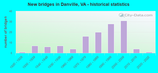
- New bridges - historical statistics
- 11920-1929
- 71930-1939
- 61940-1949
- 71950-1959
- 41960-1969
- 161970-1979
- 201980-1989
- 281990-1999
- 312000-2009
- 42010-2019
- 12020-2022

- Reconstructed bridges - Historical Statistics
- 11970-1979
- 31980-1989
- 21990-1999
- 22000-2009
- 22010-2019


- Bridge Condition - Deck
- 2.6%Very good
- 65.8%Good
- 28.9%Satisfactory
- 2.6%Fair

- Bridge Condition - Superstructure
- 7.9%Very good
- 57.9%Good
- 26.3%Satisfactory
- 6.6%Fair
- 1.3%Poor

- Bridge Condition - Substructure
- 5.3%Very good
- 56.6%Good
- 26.3%Satisfactory
- 10.5%Fair
- 1.3%Poor

- Bridge Condition - Channel
- 13.3%Very good
- 33.3%Good
- 38.3%Satisfactory
- 15.0%Fair

- Bridge Condition - Culverts
- 5.0%Very good
- 45.0%Good
- 30.0%Satisfactory
- 10.0%Fair
- 10.0%Poor
Find on map >> Show street view
Structure Number: 2103, Location: 1.65 RT 1205- 0.05 RT 608 (Lat: 37.994381, Lng: -79.133989), Route carried "on" structure: County highway 662, Year Built: 1991, Status: Open, Structure Length: 3.35m (10.99ft), Average Daily Traffic: 1,253 (year 2020), Truck Traffic: 3%, Average Future Daily Traffic: 1,378 (year 2040), Design Load: HS 20+Mod, Features Intersected: PINE RUN, Facility Carried by Structure: GREENVILLESCHOOLRD
Minimum Vertical Clearance: 30+ m (98+ ft), Kilometerpoint: 9.545, Lanes on structure: 2, Owner: State Highway Agency, Approaching Roadway Width: 7.9m (25.9ft), Material/Design: Concrete continuous, Design/Construction: Slab, Number Of Spans In Main Unit: 2, Length of Maximum Span: 16.2m (53.1ft), Curb-To-Curb Width: 9.8m (32.2ft), Out-to-Out Width: 10.8m (35.4ft)
Condition: Deck: Good, Superstructure: Good, Substructure: Very good, Channel: Satisfactory, Operating Rating: 74.4 metric tons, Method Used To Determine Operating Rating: Load and Resistance Factor (LRFR), Inventory Rating: 57.2 metric tons, Method Used To Determine Inventory Rating: Load and Resistance Factor (LRFR), Structural Evaluation: Better than present minimum criteria, Deck Geometry: Somewhat better than minimum adequacy, Waterway Adequacy: Equal to present minimum criteria, Approach Roadway Alignment: Equal to present desirable criteria, Designated Inspection Frequency: Every 24 months, Inspection Date: November 2021, Deck Structure Type: Concrete Cast-file-Place, Wearing Surface/Protective System: Wearing Surface: Epoxy Overlay, Deck Protection: Epoxy Coated Reinforcing
Find on map >> Show street view
Structure Number: 13419, Location: 0.98 NCL Danv/1.40 Rt 721 (Lat: 36.650467, Lng: -79.379142), Route carried "on" structure: Business US 29, Year Built: 1930, Status: Open, Structure Length: 2.97m (9.74ft), Average Daily Traffic: 10,156 (year 2020), Truck Traffic: 3%, Average Future Daily Traffic: 11,172 (year 2040), Features Intersected: Fall Creek
Minimum Vertical Clearance: 30+ m (98+ ft), Kilometerpoint: 16.508, Lanes on structure: 5, Base Highway Network: Yes, Owner: State Highway Agency, Approaching Roadway Width: 21.3m (69.9ft), Material/Design: Prestressed concrete, Design/Construction: Tee Beam, Number Of Spans In Main Unit: 3, Length of Maximum Span: 9.1m (29.9ft), Curb or Sidewalk Widths: Left: 1.5m (4.9ft), Right: 1.5m (4.9ft), Curb-To-Curb Width: 21.3m (69.9ft), Out-to-Out Width: 25.2m (82.7ft)
Condition: Deck: Satisfactory, Superstructure: Satisfactory, Substructure: Satisfactory, Channel: Satisfactory, Operating Rating: 51.7 metric tons, Method Used To Determine Operating Rating: Load Factor (LF), Inventory Rating: 30.8 metric tons, Method Used To Determine Inventory Rating: Load Factor (LF), Structural Evaluation: Equal to present minimum criteria, Deck Geometry: Somewhat better than minimum adequacy, Waterway Adequacy: Equal to present minimum criteria, Approach Roadway Alignment: Equal to present desirable criteria, Length Of Structure Improvement: 2.99m (9.81ft), Designated Inspection Frequency: Every 24 months, Inspection Date: September 2021, Bridge Improvement Cost: $360,000, Roadway Improvement Cost: $36,000, Total Project Cost: $540,000, Deck Structure Type: Concrete Cast-file-Place, Wearing Surface/Protective System: Wearing Surface: Latex Concrete
Find on map >> Show street view
Structure Number: 13505, Location: 0.41 NC Line/ 0.20 Rt1121 (Lat: 36.546778, Lng: -79.400386), Route carried "on" structure: State highway 86, Year Built: 1984, Status: Open, Structure Length: 7.84m (25.72ft), Average Daily Traffic: 10,453 (year 2020), Truck Traffic: 2%, Average Future Daily Traffic: 11,903 (year 2040), Design Load: HS 20+Mod, Features Intersected: Route 29 Bypass, Facility Carried by Structure: South Main Street
Minimum Vertical Clearance: 5.36m (17.59ft), Kilometerpoint: 0.582, Lanes on structure: 6, Lanes under structure: 4, Base Highway Network: Yes, Owner: State Highway Agency, Approaching Roadway Width: 30.5m (100.1ft), Skew: 1 degrees, Material/Design: Steel continuous, Design/Construction: Stringer/Multi-beam, Number Of Spans In Main Unit: 2, Length of Maximum Span: 38.7m (127.0ft), Curb-To-Curb Width: 28.0m (91.9ft), Out-to-Out Width: 29.0m (95.1ft)
Condition: Deck: Satisfactory, Superstructure: Satisfactory, Substructure: Fair, Operating Rating: 77.1 metric tons, Method Used To Determine Operating Rating: Load and Resistance Factor (LRFR), Inventory Rating: 52.6 metric tons, Method Used To Determine Inventory Rating: Load and Resistance Factor (LRFR), Structural Evaluation: Somewhat better than minimum adequacy, Deck Geometry: Superior to present desirable criteria, Underclear: Better than present minimum criteria, Approach Roadway Alignment: Equal to present desirable criteria, Designated Inspection Frequency: Every 24 months, Inspection Date: March 2020, Deck Structure Type: Concrete Precast Panels, Wearing Surface/Protective System: Deck Protection: Epoxy Coated Reinforcing
Find on map >> Show street view
Structure Number: 13511, Location: 0.00-1157/0.2-NC SL (Lat: 36.543472, Lng: -79.458231), Route carried "on" structure: Bypass State highway 29, Year Built: 1980, Status: Open, Structure Length: 3.13m (10.27ft), Average Daily Traffic: 7,483 (year 2020), Truck Traffic: 7%, Average Future Daily Traffic: 10,476 (year 2040), Design Load: HS 20+Mod, Features Intersected: Route 1353
Minimum Vertical Clearance: 30+ m (98+ ft), Kilometerpoint: 0.644, Lanes on structure: 2, Lanes under structure: 2, Base Highway Network: Yes, Owner: State Highway Agency, Approaching Roadway Width: 14.9m (48.9ft), Skew: 2 degrees, Material/Design: Steel, Design/Construction: Stringer/Multi-beam, Number Of Spans In Main Unit: 1, Length of Maximum Span: 29.8m (97.8ft), Curb-To-Curb Width: 12.3m (40.4ft), Out-to-Out Width: 13.4m (44.0ft)
Condition: Deck: Satisfactory, Superstructure: Good, Substructure: Satisfactory, Operating Rating: 58.1 metric tons, Method Used To Determine Operating Rating: Load and Resistance Factor (LRFR), Inventory Rating: 44.5 metric tons, Method Used To Determine Inventory Rating: Load and Resistance Factor (LRFR), Structural Evaluation: Equal to present minimum criteria, Deck Geometry: Better than present minimum criteria, Underclear: Better than present minimum criteria, Approach Roadway Alignment: Equal to present desirable criteria, Designated Inspection Frequency: Every 24 months, Inspection Date: Febuary 2022, Deck Structure Type: Concrete Cast-file-Place, Wearing Surface/Protective System: Wearing Surface: Latex Concrete
Find on map >> Show street view
Structure Number: 13513, Location: 0.36-29N Bus/0.32-Rt.786 (Lat: 36.543206, Lng: -79.458300), Route carried "on" structure: Bypass State highway 29, Year Built: 1980, Year Reconstructed: 2002, Status: Open, Structure Length: 3.13m (10.27ft), Average Daily Traffic: 7,483 (year 2020), Truck Traffic: 17%, Average Future Daily Traffic: 10,476 (year 2040), Design Load: HS 20+Mod, Features Intersected: Route 1156
Minimum Vertical Clearance: 30+ m (98+ ft), Kilometerpoint: 0.644, Lanes on structure: 3, Lanes under structure: 2, Base Highway Network: Yes, Owner: State Highway Agency, Approaching Roadway Width: 17.1m (56.1ft), Skew: 2 degrees, Material/Design: Steel, Design/Construction: Stringer/Multi-beam, Number Of Spans In Main Unit: 1, Length of Maximum Span: 29.8m (97.8ft), Curb or Sidewalk Widths: Left: 0.5m (1.6ft), Right: 0.5m (1.6ft), Curb-To-Curb Width: 16.8m (55.1ft), Out-to-Out Width: 17.8m (58.4ft)
Condition: Deck: Satisfactory, Superstructure: Fair, Substructure: Satisfactory, Operating Rating: 48.1 metric tons, Method Used To Determine Operating Rating: Load and Resistance Factor (LRFR), Inventory Rating: 37.2 metric tons, Method Used To Determine Inventory Rating: Load and Resistance Factor (LRFR), Structural Evaluation: Somewhat better than minimum adequacy, Deck Geometry: Equal to present minimum criteria, Underclear: Better than present minimum criteria, Approach Roadway Alignment: Equal to present desirable criteria, Length Of Structure Improvement: 3.93m (12.89ft), Designated Inspection Frequency: Every 24 months, Inspection Date: August 2020, Bridge Improvement Cost: $1,127,000, Roadway Improvement Cost: $113,000, Total Project Cost: $1,691,000 ( Estimate for 2015), Deck Structure Type: Concrete Cast-file-Place, Wearing Surface/Protective System: Wearing Surface: Latex Concrete
Find on map >> Show street view
Structure Number: 13515, Location: 1.15 TO 1123 - 0.60 TO 86 (Lat: 36.545444, Lng: -79.411822), Route carried "on" structure: Bypass State highway 29, Year Built: 1980, Status: Open, Structure Length: 1.49m (4.89ft), Average Daily Traffic: 17,298 (year 2020), Truck Traffic: 17%, Average Future Daily Traffic: 22,657 (year 2040), Features Intersected: Pumpkin Creek
Minimum Vertical Clearance: 30+ m (98+ ft), Kilometerpoint: 5.018, Lanes on structure: 4, Base Highway Network: Yes, Owner: State Highway Agency, Approaching Roadway Width: 8.5m (27.9ft), Skew: 3 degrees, Material/Design: Concrete, Design/Construction: Culvert, Number Of Spans In Main Unit: 4, Length of Maximum Span: 3.5m (11.5ft)
Condition: Channel: Satisfactory, Culverts: Fair, Operating Rating: 89.8 metric tons, Method Used To Determine Operating Rating: Load Factor (LF), Inventory Rating: 89.8 metric tons, Method Used To Determine Inventory Rating: Load Factor (LF), Structural Evaluation: Somewhat better than minimum adequacy, Waterway Adequacy: Equal to present desirable criteria, Approach Roadway Alignment: Equal to present desirable criteria, Length Of Structure Improvement: 1.55m (5.09ft), Designated Inspection Frequency: Every 24 months, Inspection Date: May 2020, Bridge Improvement Cost: $2,568,000, Roadway Improvement Cost: $257,000, Total Project Cost: $3,852,000
Find on map >> Show street view
Structure Number: 13517, Location: 1.24-Rt 86/ 0.73-Rt 737 (Lat: 36.559125, Lng: -79.386558), Route carried "on" structure: Bypass State highway 29, Year Built: 1984, Status: Open, Structure Length: 6.19m (20.31ft), Average Daily Traffic: 8,649 (year 2020), Truck Traffic: 17%, Average Future Daily Traffic: 12,109 (year 2040), Design Load: HS 20+Mod, Features Intersected: Pumpkin Creek
Minimum Vertical Clearance: 30+ m (98+ ft), Kilometerpoint: 8.106, Lanes on structure: 1, Base Highway Network: Yes, Owner: State Highway Agency, Approaching Roadway Width: 11.3m (37.1ft), Skew: 1 degrees, Material/Design: Steel, Design/Construction: Stringer/Multi-beam, Number Of Spans In Main Unit: 3, Length of Maximum Span: 19.2m (63.0ft), Curb-To-Curb Width: 5.2m (17.1ft), Out-to-Out Width: 13.4m (44.0ft)
Condition: Deck: Satisfactory, Superstructure: Satisfactory, Substructure: Fair, Channel: Fair, Operating Rating: 89.8 metric tons, Method Used To Determine Operating Rating: Load and Resistance Factor (LRFR), Inventory Rating: 84.4 metric tons, Method Used To Determine Inventory Rating: Load and Resistance Factor (LRFR), Structural Evaluation: Somewhat better than minimum adequacy, Deck Geometry: High priority of replacement, Waterway Adequacy: Superior to present desirable criteria, Approach Roadway Alignment: Equal to present desirable criteria, Designated Inspection Frequency: Every 24 months, Inspection Date: Febuary 2022, Deck Structure Type: Concrete Precast Panels, Wearing Surface/Protective System: Wearing Surface: Monolithic Concrete, Deck Protection: Epoxy Coated Reinforcing
Find on map >> Show street view
Structure Number: 13518, Location: 0.22-Rt.737 / 1.21-Rt.58 (Lat: 36.569117, Lng: -79.374558), Route carried "on" structure: Bypass State highway 29, Year Built: 1986, Status: Open, Structure Length: 29.35m (96.29ft), Average Daily Traffic: 9,639 (year 2020), Truck Traffic: 17%, Average Future Daily Traffic: 13,495 (year 2040), Design Load: HS 20+Mod, Features Intersected: Dan River
Minimum Vertical Clearance: 30+ m (98+ ft), Kilometerpoint: 9.493, Lanes on structure: 2, Base Highway Network: Yes, Owner: State Highway Agency, Approaching Roadway Width: 12.5m (41.0ft), Material/Design: Steel continuous, Design/Construction: Stringer/Multi-beam, Number Of Spans In Main Unit: 8, Length of Maximum Span: 35.4m (116.1ft), Curb-To-Curb Width: 12.3m (40.4ft), Out-to-Out Width: 13.4m (44.0ft)
Condition: Deck: Satisfactory, Superstructure: Satisfactory, Substructure: Satisfactory, Channel: Fair, Operating Rating: 88.9 metric tons, Method Used To Determine Operating Rating: Load and Resistance Factor (LRFR), Inventory Rating: 68.9 metric tons, Method Used To Determine Inventory Rating: Load and Resistance Factor (LRFR), Structural Evaluation: Equal to present minimum criteria, Deck Geometry: Better than present minimum criteria, Waterway Adequacy: Superior to present desirable criteria, Approach Roadway Alignment: Equal to present desirable criteria, Designated Inspection Frequency: Every 24 months, Inspection Date: March 2020, Deck Structure Type: Concrete Precast Panels, Wearing Surface/Protective System: Deck Protection: Epoxy Coated Reinforcing
Find on map >> Show street view
Structure Number: 13519, Location: 0.11-Rt 737 / 1.46-Rt 58 (Lat: 36.568256, Lng: -79.376039), Route carried "on" structure: Bypass US 29, Year Built: 1986, Status: Open, Structure Length: 5.09m (16.70ft), Average Daily Traffic: 8,649 (year 2020), Truck Traffic: 17%, Average Future Daily Traffic: 12,109 (year 2040), Design Load: HS 20+Mod, Features Intersected: NS Railroad
Minimum Vertical Clearance: 30+ m (98+ ft), Kilometerpoint: 9.364, Lanes on structure: 3, Base Highway Network: Yes, Owner: State Highway Agency, Approaching Roadway Width: 16.8m (55.1ft), Skew: 1 degrees, Material/Design: Steel, Design/Construction: Stringer/Multi-beam, Number Of Spans In Main Unit: 3, Length of Maximum Span: 18.7m (61.4ft), Curb-To-Curb Width: 16.0m (52.5ft), Out-to-Out Width: 17.0m (55.8ft)
Condition: Deck: Satisfactory, Superstructure: Fair, Substructure: Good, Operating Rating: 89.8 metric tons, Method Used To Determine Operating Rating: Load and Resistance Factor (LRFR), Inventory Rating: 81.6 metric tons, Method Used To Determine Inventory Rating: Load and Resistance Factor (LRFR), Structural Evaluation: Somewhat better than minimum adequacy, Deck Geometry: Equal to present minimum criteria, Underclear: Equal to present minimum criteria, Approach Roadway Alignment: Equal to present desirable criteria, Designated Inspection Frequency: Every 24 months, Inspection Date: March 2020, Deck Structure Type: Concrete Precast Panels, Wearing Surface/Protective System: Wearing Surface: Monolithic Concrete, Deck Protection: Epoxy Coated Reinforcing
Find on map >> Show street view
Structure Number: 1352, Location: 0.53 737 - 0.20 River Pk (Lat: 36.571492, Lng: -79.370006), Route carried "on" structure: Bypass State highway 29, Year Built: 1986, Year Reconstructed: 2019, Status: Open, Structure Length: 0.74m (2.43ft), Average Daily Traffic: 19,278 (year 2020), Truck Traffic: 17%, Average Future Daily Traffic: 26,989 (year 2040), Features Intersected: Barker's Branch
Minimum Vertical Clearance: 30+ m (98+ ft), Kilometerpoint: 10.008, Lanes on structure: 4, Base Highway Network: Yes, Owner: State Highway Agency, Approaching Roadway Width: 15.8m (51.8ft), Skew: 4 degrees, Material/Design: Steel, Design/Construction: Culvert, Number Of Spans In Main Unit: 2, Length of Maximum Span: 2.6m (8.5ft)
Condition: Channel: Satisfactory, Culverts: Satisfactory, Operating Rating: 89.8 metric tons, Method Used To Determine Operating Rating: Field evaluation and documented engineering judgment, Inventory Rating: 89.8 metric tons, Method Used To Determine Inventory Rating: Field evaluation and documented engineering judgment, Structural Evaluation: Equal to present minimum criteria, Waterway Adequacy: Superior to present desirable criteria, Approach Roadway Alignment: Equal to present desirable criteria, Length Of Structure Improvement: 0.76m (2.49ft), Designated Inspection Frequency: Every 24 months, Inspection Date: May 2021, Bridge Improvement Cost: $1,360,000, Roadway Improvement Cost: $136,000, Total Project Cost: $2,040,000
Find on map >> Show street view
Structure Number: 13587, Location: 0.62 TO 734 -0.30 TO 1299 (Lat: 36.584319, Lng: -79.316597), Route carried "on" structure: County highway 655, Year Built: 1932, Year Reconstructed: 2018, Status: Open, Structure Length: 0.94m (3.08ft), Average Daily Traffic: 258 (year 2020), Truck Traffic: 2%, Average Future Daily Traffic: 284 (year 2040), Design Load: HL 93, Features Intersected: Cane Creek, Facility Carried by Structure: Tom Fork Road
Minimum Vertical Clearance: 30+ m (98+ ft), Kilometerpoint: 3.203, Lanes on structure: 2, Owner: State Highway Agency, Approaching Roadway Width: 5.5m (18.0ft), Material/Design: Concrete, Design/Construction: Slab, Number Of Spans In Main Unit: 1, Length of Maximum Span: 8.5m (27.9ft), Curb or Sidewalk Widths: Left: 0.2m (0.7ft), Right: 0.2m (0.7ft), Curb-To-Curb Width: 6.6m (21.7ft), Out-to-Out Width: 7.4m (24.3ft)
Condition: Deck: Good, Superstructure: Good, Substructure: Good, Channel: Good, Operating Rating: 62.6 metric tons, Method Used To Determine Operating Rating: Load and Resistance Factor (LRFR), Inventory Rating: 48.1 metric tons, Method Used To Determine Inventory Rating: Load and Resistance Factor (LRFR), Structural Evaluation: Better than present minimum criteria, Deck Geometry: Meets minimum limits, Waterway Adequacy: Better than present minimum criteria, Approach Roadway Alignment: Equal to present desirable criteria, Length Of Structure Improvement: 1.65m (5.41ft), Designated Inspection Frequency: Every 24 months, Inspection Date: August 2020, Bridge Improvement Cost: $287,000, Roadway Improvement Cost: $29,000, Total Project Cost: $431,000 ( Estimate for 2015), Deck Structure Type: Other, Wearing Surface/Protective System: Wearing Surface: Bituminous
Find on map >> Show street view
Structure Number: 13666, Location: 1.20 TO 41 - 1.20 TO 745 (Lat: 36.655586, Lng: -79.389989), Route carried "on" structure: County highway 727, Year Built: 1978, Status: Open, Structure Length: 1.23m (4.04ft), Average Daily Traffic: 392 (year 2015), Average Future Daily Traffic: 441 (year 2040), Design Load: HS 20, Features Intersected: Fall Creek, Facility Carried by Structure: Afton Road
Minimum Vertical Clearance: 30+ m (98+ ft), Kilometerpoint: 1.942, Lanes on structure: 2, Owner: State Highway Agency, Approaching Roadway Width: 6.1m (20.0ft), Material/Design: Steel, Design/Construction: Culvert, Number Of Spans In Main Unit: 3, Length of Maximum Span: 3.6m (11.8ft)
Condition: Channel: Fair, Culverts: Poor, Operating Rating: 44.5 metric tons, Method Used To Determine Operating Rating: Field evaluation and documented engineering judgment, Inventory Rating: 32.7 metric tons, Method Used To Determine Inventory Rating: Field evaluation and documented engineering judgment, Structural Evaluation: Meets minimum limits, Waterway Adequacy: Equal to present minimum criteria, Approach Roadway Alignment: Equal to present desirable criteria, Length Of Structure Improvement: 1.25m (4.10ft), Designated Inspection Frequency: Every 6 months, Inspection Date: Febuary 2022, Bridge Improvement Cost: $354,000, Roadway Improvement Cost: $35,000, Total Project Cost: $531,000
Find on map >> Show street view
Structure Number: 13667, Location: 1.10 TO 732 - 0.80 TO 730 (Lat: 36.627489, Lng: -79.281869), Route carried "on" structure: County highway 728, Year Built: 1979, Status: Open, Structure Length: 0.67m (2.20ft), Average Daily Traffic: 224 (year 2015), Average Future Daily Traffic: 252 (year 2040), Features Intersected: SANDY CREEK, Facility Carried by Structure: HILLSIDE ROAD
Minimum Vertical Clearance: 30+ m (98+ ft), Kilometerpoint: 1.287, Lanes on structure: 2, Owner: State Highway Agency, Approaching Roadway Width: 5.5m (18.0ft), Material/Design: Steel, Design/Construction: Culvert, Number Of Spans In Main Unit: 2, Length of Maximum Span: 3.0m (9.8ft)
Condition: Channel: Fair, Culverts: Satisfactory, Operating Rating: 52.6 metric tons, Method Used To Determine Operating Rating: Field evaluation and documented engineering judgment, Inventory Rating: 31.8 metric tons, Method Used To Determine Inventory Rating: Field evaluation and documented engineering judgment, Structural Evaluation: Equal to present minimum criteria, Waterway Adequacy: Equal to present minimum criteria, Approach Roadway Alignment: Equal to present desirable criteria, Length Of Structure Improvement: 0.67m (2.20ft), Designated Inspection Frequency: Every 24 months, Underwater Inspection Frequency: Every 21 months, Inspection Date: May 2020, Underwater Inspection Date: Febuary 2022, Bridge Improvement Cost: $244,000, Roadway Improvement Cost: $24,000, Total Project Cost: $366,000
Find on map >> Show street view
Structure Number: 13669, Location: 0.05-Rt.730/0.20-Bright R (Lat: 36.601425, Lng: -79.336569), Route carried "on" structure: County highway 729, Year Built: 1961, Status: Open, Structure Length: 4.56m (14.96ft), Average Daily Traffic: 6,428 (year 2020), Truck Traffic: 7%, Average Future Daily Traffic: 8,247 (year 2040), Features Intersected: NS Railroad, Facility Carried by Structure: Kentuck Road
Minimum Vertical Clearance: 30+ m (98+ ft), Kilometerpoint: 0.068, Lanes on structure: 2, Base Highway Network: Yes, Owner: State Highway Agency, Approaching Roadway Width: 7.9m (25.9ft), Skew: 1 degrees, Material/Design: Steel, Design/Construction: Stringer/Multi-beam, Number Of Spans In Main Unit: 3, Length of Maximum Span: 15.1m (49.5ft), Curb or Sidewalk Widths: Left: 0.5m (1.6ft), Right: 0.5m (1.6ft), Curb-To-Curb Width: 8.5m (27.9ft), Out-to-Out Width: 10.1m (33.1ft)
Condition: Deck: Fair, Superstructure: Fair, Substructure: Fair, Operating Rating: 51.7 metric tons, Method Used To Determine Operating Rating: Load and Resistance Factor (LRFR), Inventory Rating: 39.9 metric tons, Method Used To Determine Inventory Rating: Load and Resistance Factor (LRFR), Structural Evaluation: Somewhat better than minimum adequacy, Deck Geometry: High priority of replacement, Underclear: Equal to present minimum criteria, Approach Roadway Alignment: Equal to present desirable criteria, Length Of Structure Improvement: 5.55m (18.21ft), Designated Inspection Frequency: Every 24 months, Inspection Date: January 2022, Bridge Improvement Cost: $561,000, Roadway Improvement Cost: $56,000, Total Project Cost: $841,000 ( Estimate for 2014), Deck Structure Type: Concrete Cast-file-Place, Wearing Surface/Protective System: Wearing Surface: Monolithic Concrete
Find on map >> Show street view
Structure Number: 13674, Location: 0.04 TO 958 - 0.66 TO 729 (Lat: 36.604372, Lng: -79.326139), Route carried "on" structure: County highway 730, Year Built: 1980, Status: Open, Structure Length: 0.73m (2.40ft), Average Daily Traffic: 1,063 (year 2020), Truck Traffic: 2%, Average Future Daily Traffic: 1,450 (year 2040), Features Intersected: Cane Creek, Facility Carried by Structure: Wilkerson Road
Minimum Vertical Clearance: 30+ m (98+ ft), Kilometerpoint: 2.391, Lanes on structure: 2, Owner: State Highway Agency, Approaching Roadway Width: 7.3m (24.0ft), Material/Design: Steel, Design/Construction: Culvert, Number Of Spans In Main Unit: 2, Length of Maximum Span: 3.1m (10.2ft)
Condition: Channel: Good, Culverts: Satisfactory, Operating Rating: 52.6 metric tons, Method Used To Determine Operating Rating: Field evaluation and documented engineering judgment, Inventory Rating: 31.8 metric tons, Method Used To Determine Inventory Rating: Field evaluation and documented engineering judgment, Structural Evaluation: Equal to present minimum criteria, Waterway Adequacy: Better than present minimum criteria, Approach Roadway Alignment: Equal to present desirable criteria, Length Of Structure Improvement: 0.73m (2.40ft), Designated Inspection Frequency: Every 24 months, Inspection Date: May 2020, Bridge Improvement Cost: $256,000, Roadway Improvement Cost: $26,000, Total Project Cost: $384,000
Find on map >> Show street view
Structure Number: 13677, Location: 0.54-Rt.736/0.18-Rt.1162 (Lat: 36.566728, Lng: -79.377547), Route carried "on" structure: County highway 737, Year Built: 1984, Status: Open, Structure Length: 9.39m (30.81ft), Average Daily Traffic: 3,962 (year 2020), Truck Traffic: 7%, Average Future Daily Traffic: 4,358 (year 2040), Design Load: HS 20+Mod, Features Intersected: Route 29 Bypass, Facility Carried by Structure: Goodyear Blvd.
Minimum Vertical Clearance: 30+ m (98+ ft), Kilometerpoint: 5.052, Lanes on structure: 5, Lanes under structure: 6, Owner: State Highway Agency, Approaching Roadway Width: 18.9m (62.0ft), Skew: 22 degrees, Material/Design: Steel, Design/Construction: Stringer/Multi-beam, Number Of Spans In Main Unit: 4, Length of Maximum Span: 30.2m (99.1ft), Curb-To-Curb Width: 29.4m (96.5ft), Out-to-Out Width: 30.4m (99.7ft)
Condition: Deck: Satisfactory, Superstructure: Satisfactory, Substructure: Fair, Operating Rating: 55.3 metric tons, Method Used To Determine Operating Rating: Load and Resistance Factor (LRFR), Inventory Rating: 42.6 metric tons, Method Used To Determine Inventory Rating: Load and Resistance Factor (LRFR), Structural Evaluation: Somewhat better than minimum adequacy, Deck Geometry: Superior to present desirable criteria, Underclear: Equal to present minimum criteria, Approach Roadway Alignment: Equal to present desirable criteria, Designated Inspection Frequency: Every 24 months, Inspection Date: March 2020, Deck Structure Type: Concrete Precast Panels, Wearing Surface/Protective System: Deck Protection: Epoxy Coated Reinforcing
Find on map >> Show street view
Structure Number: 13686, Location: 0.40-Rt.750/1.70-Rt.743 (Lat: 36.634592, Lng: -79.462125), Route carried "on" structure: County highway 746, Year Built: 1978, Status: Open, Structure Length: 1.58m (5.18ft), Average Daily Traffic: 1,360 (year 2020), Truck Traffic: 3%, Average Future Daily Traffic: 1,496 (year 2040), Features Intersected: Sandy Creek, Facility Carried by Structure: Golf Club Road
Minimum Vertical Clearance: 30+ m (98+ ft), Kilometerpoint: 0.644, Lanes on structure: 2, Owner: State Highway Agency, Approaching Roadway Width: 6.1m (20.0ft), Material/Design: Steel, Design/Construction: Stringer/Multi-beam, Number Of Spans In Main Unit: 1, Length of Maximum Span: 14.0m (45.9ft), Curb-To-Curb Width: 7.9m (25.9ft), Out-to-Out Width: 8.7m (28.5ft)
Condition: Deck: Satisfactory, Superstructure: Good, Substructure: Fair, Channel: Satisfactory, Operating Rating: 62.6 metric tons, Method Used To Determine Operating Rating: Load and Resistance Factor (LRFR), Inventory Rating: 48.1 metric tons, Method Used To Determine Inventory Rating: Load and Resistance Factor (LRFR), Structural Evaluation: Somewhat better than minimum adequacy, Deck Geometry: Meets minimum limits, Waterway Adequacy: Equal to present minimum criteria, Approach Roadway Alignment: Equal to present desirable criteria, Length Of Structure Improvement: 2.26m (7.41ft), Designated Inspection Frequency: Every 24 months, Inspection Date: January 2022, Bridge Improvement Cost: $394,000, Roadway Improvement Cost: $39,000, Total Project Cost: $591,000 ( Estimate for 2014), Deck Structure Type: Concrete Cast-file-Place
Find on map >> Show street view
Structure Number: 13773, Location: 0.72-Rt 873/0.92-Rt 1530 (Lat: 36.618681, Lng: -79.501967), Route carried "on" structure: County highway 863, Year Built: 1959, Status: Open, Structure Length: 5.86m (19.23ft), Average Daily Traffic: 2,078 (year 2020), Truck Traffic: 2%, Average Future Daily Traffic: 2,095 (year 2040), Design Load: HS 15, Features Intersected: Sandy River, Facility Carried by Structure: Moorefield Bridge
Minimum Vertical Clearance: 30+ m (98+ ft), Kilometerpoint: 14.304, Lanes on structure: 2, Owner: State Highway Agency, Approaching Roadway Width: 6.4m (21.0ft), Material/Design: Concrete, Design/Construction: Tee Beam, Number Of Spans In Main Unit: 4, Length of Maximum Span: 13.6m (44.6ft), Curb or Sidewalk Widths: Left: 0.5m (1.6ft), Right: 0.5m (1.6ft), Curb-To-Curb Width: 7.3m (24.0ft), Out-to-Out Width: 8.3m (27.2ft)
Condition: Deck: Fair, Superstructure: Satisfactory, Substructure: Satisfactory, Channel: Satisfactory, Operating Rating: 48.1 metric tons, Method Used To Determine Operating Rating: Load and Resistance Factor (LRFR), Inventory Rating: 36.3 metric tons, Method Used To Determine Inventory Rating: Load and Resistance Factor (LRFR), Structural Evaluation: Equal to present minimum criteria, Deck Geometry: High priority of replacement, Waterway Adequacy: Equal to present desirable criteria, Approach Roadway Alignment: Equal to present desirable criteria, Length Of Structure Improvement: 7.50m (24.61ft), Designated Inspection Frequency: Every 24 months, Inspection Date: Febuary 2022, Bridge Improvement Cost: $1,309,000, Roadway Improvement Cost: $131,000, Total Project Cost: $1,963,000 ( Estimate for 2014), Deck Structure Type: Concrete Cast-file-Place, Wearing Surface/Protective System: Wearing Surface: Latex Concrete
Find on map >> Show street view
Structure Number: 13782, Location: 0.80 TO 876 - 0.34 TO 878 (Lat: 36.631647, Lng: -79.556867), Route carried "on" structure: County highway 869, Year Built: 1975, Status: Open, Structure Length: 0.68m (2.23ft), Average Daily Traffic: 1,661 (year 2020), Truck Traffic: 3%, Average Future Daily Traffic: 1,799 (year 2040), Features Intersected: Hardys Creek, Facility Carried by Structure: Stony Mill Road
Minimum Vertical Clearance: 30+ m (98+ ft), Kilometerpoint: 2.911, Lanes on structure: 2, Owner: State Highway Agency, Approaching Roadway Width: 7.3m (24.0ft), Material/Design: Concrete, Design/Construction: Culvert, Number Of Spans In Main Unit: 3, Length of Maximum Span: 2.1m (6.9ft)
Condition: Channel: Satisfactory, Culverts: Satisfactory, Operating Rating: 89.8 metric tons, Method Used To Determine Operating Rating: Load Factor (LF), Inventory Rating: 89.8 metric tons, Method Used To Determine Inventory Rating: Load Factor (LF), Structural Evaluation: Equal to present minimum criteria, Waterway Adequacy: Equal to present minimum criteria, Approach Roadway Alignment: Equal to present desirable criteria, Length Of Structure Improvement: 0.76m (2.49ft), Designated Inspection Frequency: Every 24 months, Inspection Date: Febuary 2022, Bridge Improvement Cost: $420,000, Roadway Improvement Cost: $42,000, Total Project Cost: $630,000
Find on map >> Show street view
Structure Number: 13784, Location: 0.35 TO 58 - 1.37 TO 872 (Lat: 36.590900, Lng: -79.500150), Route carried "on" structure: County highway 870, Year Built: 1990, Status: Open, Structure Length: 0.67m (2.20ft), Average Daily Traffic: 913 (year 2015), Average Future Daily Traffic: 1,356 (year 2040), Features Intersected: Trib. Dan River, Facility Carried by Structure: Vandola Road
Minimum Vertical Clearance: 30+ m (98+ ft), Kilometerpoint: 4.677, Lanes on structure: 2, Owner: State Highway Agency, Approaching Roadway Width: 7.9m (25.9ft), Skew: 1 degrees, Material/Design: Concrete, Design/Construction: Culvert, Number Of Spans In Main Unit: 2, Length of Maximum Span: 2.8m (9.2ft)
Condition: Channel: Satisfactory, Culverts: Fair, Operating Rating: 89.8 metric tons, Method Used To Determine Operating Rating: Load Factor (LF), Inventory Rating: 89.8 metric tons, Method Used To Determine Inventory Rating: Load Factor (LF), Structural Evaluation: Somewhat better than minimum adequacy, Waterway Adequacy: Superior to present desirable criteria, Approach Roadway Alignment: Equal to present desirable criteria, Length Of Structure Improvement: 0.67m (2.20ft), Designated Inspection Frequency: Every 24 months, Inspection Date: Febuary 2022, Bridge Improvement Cost: $636,000, Roadway Improvement Cost: $64,000, Total Project Cost: $954,000
Find on map >> Show street view
Structure Number: 13816, Location: 0.07-Rt.1159/0.10-Rt.1120 (Lat: 36.546117, Lng: -79.432206), Route carried "on" structure: County highway 1123, Year Built: 1979, Status: Open, Structure Length: 7.13m (23.39ft), Average Daily Traffic: 511 (year 2020), Truck Traffic: 3%, Average Future Daily Traffic: 562 (year 2040), Design Load: HS 20+Mod, Features Intersected: Route 29 Bypass, Facility Carried by Structure: Holland Road
Minimum Vertical Clearance: 30+ m (98+ ft), Kilometerpoint: 0.354, Lanes on structure: 2, Lanes under structure: 4, Owner: State Highway Agency, Approaching Roadway Width: 8.2m (26.9ft), Material/Design: Steel continuous, Design/Construction: Stringer/Multi-beam, Number Of Spans In Main Unit: 2, Length of Maximum Span: 35.8m (117.5ft), Curb-To-Curb Width: 10.5m (34.4ft), Out-to-Out Width: 11.5m (37.7ft)
Condition: Deck: Good, Superstructure: Good, Substructure: Satisfactory, Operating Rating: 59.9 metric tons, Method Used To Determine Operating Rating: Load and Resistance Factor (LRFR), Inventory Rating: 46.3 metric tons, Method Used To Determine Inventory Rating: Load and Resistance Factor (LRFR), Structural Evaluation: Equal to present minimum criteria, Deck Geometry: Equal to present minimum criteria, Underclear: Somewhat better than minimum adequacy, Approach Roadway Alignment: Equal to present desirable criteria, Designated Inspection Frequency: Every 24 months, Inspection Date: Febuary 2022, Deck Structure Type: Concrete Cast-file-Place, Wearing Surface/Protective System: Deck Protection: Epoxy Coated Reinforcing
Find on map >> Show street view
Structure Number: 13824, Location: 0.0 TO DCL-0.85 TO DEADEN (Lat: 36.606428, Lng: -79.419372), Route carried "on" structure: County highway 1529, Year Built: 1977, Status: Open, Structure Length: 1.25m (4.10ft), Average Daily Traffic: 430 (year 2015), Average Future Daily Traffic: 550 (year 2035), Features Intersected: Branch Sandy Creek, Facility Carried by Structure: Parker Road
Minimum Vertical Clearance: 30+ m (98+ ft), Kilometerpoint: 1.363, Lanes on structure: 2, Owner: State Highway Agency, Approaching Roadway Width: 6.1m (20.0ft), Skew: 4 degrees, Material/Design: Steel, Design/Construction: Culvert, Number Of Spans In Main Unit: 3, Length of Maximum Span: 3.3m (10.8ft)
Condition: Channel: Fair, Culverts: Poor, Operating Rating: 48.1 metric tons, Method Used To Determine Operating Rating: Field evaluation and documented engineering judgment, Inventory Rating: 29.0 metric tons, Method Used To Determine Inventory Rating: Field evaluation and documented engineering judgment, Structural Evaluation: Meets minimum limits, Waterway Adequacy: Equal to present minimum criteria, Approach Roadway Alignment: Equal to present desirable criteria, Length Of Structure Improvement: 0.70m (2.30ft), Designated Inspection Frequency: Every 24 months, Inspection Date: May 2020, Bridge Improvement Cost: $480,000, Roadway Improvement Cost: $48,000, Total Project Cost: $720,000
Find on map >> Show street view
Structure Number: 20173, Location: .05 Memorial Dr/.18 Rt.58 (Lat: 36.592803, Lng: -79.397586), Route carried "on" structure: City street , Year Built: 1934, Year Reconstructed: 1994, Status: Open, Structure Length: 32.00m (104.99ft), Average Daily Traffic: 7,115 (year 2020), Truck Traffic: 1%, Average Future Daily Traffic: 7,826 (year 2040), Design Load: HL 93, Features Intersected: Dan River, Facility Carried by Structure: Union Street
Minimum Vertical Clearance: 30+ m (98+ ft), Kilometerpoint: 0.000, Lanes on structure: 2, Owner: City or Municipal Highway Agency, Approaching Roadway Width: 8.5m (27.9ft), Material/Design: Steel continuous, Design/Construction: Stringer/Multi-beam, Number Of Spans In Main Unit: 13, Length of Maximum Span: 27.9m (91.5ft), Curb or Sidewalk Widths: Left: 0.0m, Right: 1.5m (4.9ft), Curb-To-Curb Width: 8.5m (27.9ft), Out-to-Out Width: 10.9m (35.8ft)
Condition: Deck: Good, Superstructure: Good, Substructure: Good, Channel: Good, Operating Rating: 40.8 metric tons, Method Used To Determine Operating Rating: Load and Resistance Factor (LRFR), Inventory Rating: 31.8 metric tons, Method Used To Determine Inventory Rating: Load and Resistance Factor (LRFR), Structural Evaluation: Better than present minimum criteria, Deck Geometry: Meets minimum limits, Waterway Adequacy: Equal to present minimum criteria, Approach Roadway Alignment: Somewhat better than minimum adequacy, Length Of Structure Improvement: 35.20m (115.49ft), Designated Inspection Frequency: Every 24 months, Inspection Date: August 2020, Bridge Improvement Cost: $5,844,000, Roadway Improvement Cost: $584,000, Total Project Cost: $8,766,000 ( Estimate for 2014), Deck Structure Type: Concrete Cast-file-Place, Wearing Surface/Protective System: Deck Protection: Epoxy Coated Reinforcing
Find on map >> Show street view
Structure Number: 20176, Location: 0.4 to Mt.Cross-0.0 to 58 (Lat: 36.589600, Lng: -79.420800), Route carried "on" structure: City street , Year Built: 1984, Status: Open, Structure Length: 5.15m (16.90ft), Average Daily Traffic: 3,226 (year 2020), Truck Traffic: 1%, Average Future Daily Traffic: 4,135 (year 2040), Design Load: HS 20+Mod, Features Intersected: Sandy River, Facility Carried by Structure: Old Riverside Dr.
Minimum Vertical Clearance: 30+ m (98+ ft), Kilometerpoint: 0.000, Lanes on structure: 5, Owner: City or Municipal Highway Agency, Approaching Roadway Width: 16.5m (54.1ft), Material/Design: Steel continuous, Design/Construction: Stringer/Multi-beam, Number Of Spans In Main Unit: 2, Length of Maximum Span: 29.6m (97.1ft), Curb or Sidewalk Widths: Left: 1.2m (3.9ft), Right: 0.5m (1.6ft), Curb-To-Curb Width: 16.5m (54.1ft), Out-to-Out Width: 18.7m (61.4ft)
Condition: Deck: Good, Superstructure: Good, Substructure: Satisfactory, Channel: Very good, Operating Rating: 49.9 metric tons, Method Used To Determine Operating Rating: Load Factor (LF), Inventory Rating: 26.3 metric tons, Method Used To Determine Inventory Rating: Load Factor (LF), Structural Evaluation: Equal to present minimum criteria, Deck Geometry: High priority of replacement, Waterway Adequacy: Equal to present desirable criteria, Approach Roadway Alignment: Better than present minimum criteria, Length Of Structure Improvement: 5.15m (16.90ft), Designated Inspection Frequency: Every 24 months, Inspection Date: January 2021, Bridge Improvement Cost: $855,000, Roadway Improvement Cost: $85,000, Total Project Cost: $1,282,000 ( Estimate for 2015), Deck Structure Type: Concrete Cast-file-Place, Wearing Surface/Protective System: Wearing Surface: Monolithic Concrete, Deck Protection: Epoxy Coated Reinforcing
Find on map >> Show street view
Structure Number: 20177, Location: .50 - Rt. 86 (Lat: 36.560778, Lng: -79.397447), Route carried "on" structure: City street , Year Built: 1965, Status: Open, Structure Length: 1.30m (4.27ft), Average Daily Traffic: 2,000 (year 1984), Truck Traffic: 2%, Average Future Daily Traffic: 6,500 (year 2035), Design Load: HL 93, Features Intersected: Pumpkin Creek, Facility Carried by Structure: London Bridge Dr.
Minimum Vertical Clearance: 30+ m (98+ ft), Kilometerpoint: 0.000, Lanes on structure: 2, Owner: City or Municipal Highway Agency, Approaching Roadway Width: 11.0m (36.1ft), Material/Design: Concrete, Design/Construction: Tee Beam, Number Of Spans In Main Unit: 1, Length of Maximum Span: 12.2m (40.0ft), Curb or Sidewalk Widths: Left: 1.5m (4.9ft), Right: 1.5m (4.9ft), Curb-To-Curb Width: 7.3m (24.0ft), Out-to-Out Width: 10.7m (35.1ft)
Condition: Deck: Satisfactory, Superstructure: Satisfactory, Substructure: Fair, Channel: Good, Operating Rating: 46.3 metric tons, Method Used To Determine Operating Rating: Load and Resistance Factor (LRFR), Inventory Rating: 35.4 metric tons, Method Used To Determine Inventory Rating: Load and Resistance Factor (LRFR), Structural Evaluation: Somewhat better than minimum adequacy, Deck Geometry: Meets minimum limits, Waterway Adequacy: Equal to present minimum criteria, Approach Roadway Alignment: Equal to present minimum criteria, Designated Inspection Frequency: Every 24 months, Inspection Date: December 2020, Deck Structure Type: Concrete Cast-file-Place, Wearing Surface/Protective System: Wearing Surface: Latex Concrete
Find on map >> Show street view
Structure Number: 20178, Location: .03-Rt.293/.05-Fairfield (Lat: 36.568458, Lng: -79.424233), Route carried "on" structure: City street , Year Built: 1930, Status: Open, Structure Length: 4.57m (14.99ft), Average Daily Traffic: 1,890 (year 1984), Truck Traffic: 1%, Average Future Daily Traffic: 2,725 (year 2032), Design Load: HL 93, Features Intersected: NS Railway&Lanier Ave, Facility Carried by Structure: Baltimore Avenue
Minimum Vertical Clearance: 30+ m (98+ ft), Kilometerpoint: 0.000, Lanes on structure: 2, Lanes under structure: 2, Owner: City or Municipal Highway Agency, Approaching Roadway Width: 9.8m (32.2ft), Material/Design: Concrete, Design/Construction: Tee Beam, Number Of Spans In Main Unit: 5, Length of Maximum Span: 10.7m (35.1ft), Curb or Sidewalk Widths: Left: 1.5m (4.9ft), Right: 1.5m (4.9ft), Curb-To-Curb Width: 6.1m (20.0ft), Out-to-Out Width: 6.6m (21.7ft)
Condition: Deck: Good, Superstructure: Satisfactory, Substructure: Satisfactory, Operating Rating: 40.8 metric tons, Method Used To Determine Operating Rating: Load and Resistance Factor (LRFR), Inventory Rating: 31.8 metric tons, Method Used To Determine Inventory Rating: Load and Resistance Factor (LRFR), Structural Evaluation: Equal to present minimum criteria, Deck Geometry: High priority of replacement, Underclear: High priority of replacement, Approach Roadway Alignment: Somewhat better than minimum adequacy, Length Of Structure Improvement: 5.33m (17.49ft), Designated Inspection Frequency: Every 24 months, Inspection Date: August 2020, Bridge Improvement Cost: $1,530,000, Roadway Improvement Cost: $153,000, Total Project Cost: $2,294,000 ( Estimate for 2014), Deck Structure Type: Concrete Cast-file-Place, Wearing Surface/Protective System: Wearing Surface: Latex Concrete
Find on map >> Show street view
Structure Number: 20181, Location: 0.37Rt.51/0.07Mt.Cross Rd (Lat: 36.592850, Lng: -79.428625), Route carried "on" structure: City street , Year Built: 1989, Status: Open, Structure Length: 9.21m (30.22ft), Average Daily Traffic: 14,299 (year 2020), Truck Traffic: 1%, Average Future Daily Traffic: 15,729 (year 2040), Design Load: HL 93, Features Intersected: Sandy River, Facility Carried by Structure: Piedmont Drive
Minimum Vertical Clearance: 30+ m (98+ ft), Kilometerpoint: 0.000, Lanes on structure: 6, Owner: City or Municipal Highway Agency, Approaching Roadway Width: 21.3m (69.9ft), Skew: 21 degrees, Material/Design: Prestressed concrete, Design/Construction: Stringer/Multi-beam, Number Of Spans In Main Unit: 4, Length of Maximum Span: 22.9m (75.1ft), Curb-To-Curb Width: 25.0m (82.0ft), Out-to-Out Width: 26.0m (85.3ft)
Condition: Deck: Good, Superstructure: Good, Substructure: Good, Channel: Good, Operating Rating: 77.1 metric tons, Method Used To Determine Operating Rating: Load and Resistance Factor (LRFR), Inventory Rating: 57.2 metric tons, Method Used To Determine Inventory Rating: Load and Resistance Factor (LRFR), Structural Evaluation: Better than present minimum criteria, Deck Geometry: Somewhat better than minimum adequacy, Waterway Adequacy: Equal to present desirable criteria, Approach Roadway Alignment: Equal to present desirable criteria, Designated Inspection Frequency: Every 24 months, Inspection Date: August 2021, Deck Structure Type: Concrete Cast-file-Place, Wearing Surface/Protective System: Deck Protection: Epoxy Coated Reinforcing
Find on map >> Show street view
Structure Number: 20183, Location: .40N.Rt.86 / 3.20S.Rt. 41 (Lat: 36.591722, Lng: -79.416211), Route carried "on" structure: Business US 29, Year Built: 1970, Status: Open, Structure Length: 5.71m (18.73ft), Average Daily Traffic: 22,199 (year 2020), Truck Traffic: 1%, Average Future Daily Traffic: 24,419 (year 2040), Design Load: HL 93, Features Intersected: Riverside Drive (Rt.58), Facility Carried by Structure: Central Boulevard
Minimum Vertical Clearance: 5.37m (17.62ft), Kilometerpoint: 8.254, Lanes on structure: 6, Lanes under structure: 6, Base Highway Network: Yes, Owner: City or Municipal Highway Agency, Approaching Roadway Width: 25.0m (82.0ft), Skew: 20 degrees, Material/Design: Steel continuous, Design/Construction: Stringer/Multi-beam, Number Of Spans In Main Unit: 2, Length of Maximum Span: 28.6m (93.8ft), Curb-To-Curb Width: 23.8m (78.1ft), Out-to-Out Width: 26.5m (86.9ft)
Condition: Deck: Good, Superstructure: Good, Substructure: Good, Operating Rating: 60.8 metric tons, Method Used To Determine Operating Rating: Load and Resistance Factor (LRFR), Inventory Rating: 47.2 metric tons, Method Used To Determine Inventory Rating: Load and Resistance Factor (LRFR), Structural Evaluation: Better than present minimum criteria, Deck Geometry: Somewhat better than minimum adequacy, Underclear: Meets minimum limits, Approach Roadway Alignment: Equal to present minimum criteria, Designated Inspection Frequency: Every 24 months, Inspection Date: September 2021, Deck Structure Type: Concrete Cast-file-Place, Wearing Surface/Protective System: Wearing Surface: Latex Concrete
Find on map >> Show street view
Structure Number: 20186, Location: .03-Clev.St/.43-Primrose (Lat: 36.588525, Lng: -79.411086), Route carried "on" structure: Business City street 29, Year Built: 1970, Year Reconstructed: 1994, Status: Open, Structure Length: 5.67m (18.60ft), Average Daily Traffic: 8,993 (year 2020), Truck Traffic: 2%, Average Future Daily Traffic: 9,892 (year 2040), Design Load: HL 93, Features Intersected: Central Boulevard, Facility Carried by Structure: Memorial Drive
Minimum Vertical Clearance: 30+ m (98+ ft), Kilometerpoint: 7.611, Lanes on structure: 6, Lanes under structure: 6, Base Highway Network: Yes, Owner: City or Municipal Highway Agency, Approaching Roadway Width: 28.7m (94.2ft), Skew: 20 degrees, Material/Design: Steel, Design/Construction: Stringer/Multi-beam, Number Of Spans In Main Unit: 3, Length of Maximum Span: 31.1m (102.0ft), Curb or Sidewalk Widths: Left: 0.5m (1.6ft), Right: 0.5m (1.6ft), Curb-To-Curb Width: 28.7m (94.2ft), Out-to-Out Width: 30.2m (99.1ft)
Condition: Deck: Good, Superstructure: Good, Substructure: Good, Operating Rating: 69.9 metric tons, Method Used To Determine Operating Rating: Load and Resistance Factor (LRFR), Inventory Rating: 53.5 metric tons, Method Used To Determine Inventory Rating: Load and Resistance Factor (LRFR), Structural Evaluation: Better than present minimum criteria, Deck Geometry: Superior to present desirable criteria, Underclear: High priority of corrective action, Approach Roadway Alignment: Equal to present minimum criteria, Designated Inspection Frequency: Every 24 months, Inspection Date: August 2021, Deck Structure Type: Concrete Cast-file-Place, Wearing Surface/Protective System: Wearing Surface: Latex Concrete
Find on map >> Show street view
Structure Number: 2019, Location: 1.00-Rt.86/0.02-Rt.58 (Lat: 36.588944, Lng: -79.388972), Route carried "on" structure: Business US 293, Year Built: 1927, Year Reconstructed: 2005, Status: Open, Structure Length: 25.11m (82.38ft), Average Daily Traffic: 5,770 (year 2020), Truck Traffic: 1%, Average Future Daily Traffic: 8,078 (year 2040), Design Load: HS 20+Mod, Features Intersected: Dan River, Facility Carried by Structure: Main Street
Minimum Vertical Clearance: 30+ m (98+ ft), Kilometerpoint: 5.487, Lanes on structure: 3, Owner: City or Municipal Highway Agency, Approaching Roadway Width: 10.9m (35.8ft), Material/Design: Concrete, Design/Construction: Arch - Deck, Number Of Spans In Main Unit: 7, Length of Maximum Span: 37.2m (122.0ft), Curb or Sidewalk Widths: Left: 0.0m, Right: 3.0m (9.8ft), Curb-To-Curb Width: 10.9m (35.8ft), Out-to-Out Width: 15.6m (51.2ft)
Condition: Deck: Good, Superstructure: Poor, Substructure: Satisfactory, Channel: Good, Operating Rating: 32.7 metric tons, Method Used To Determine Operating Rating: Load Factor (LF), Inventory Rating: 25.4 metric tons, Method Used To Determine Inventory Rating: Load Factor (LF), Structural Evaluation: Meets minimum limits, Deck Geometry: High priority of replacement, Waterway Adequacy: Better than present minimum criteria, Approach Roadway Alignment: Better than present minimum criteria, Designated Inspection Frequency: Every 6 months, Inspection Date: December 2021, Deck Structure Type: Concrete Cast-file-Place, Wearing Surface/Protective System: Wearing Surface: Monolithic Concrete
Find on map >> Show street view
Structure Number: 20191, Location: MP5.43 - 0.40-Rt. 58 (Lat: 36.597414, Lng: -79.418025), Route carried "on" structure: US 29, Year Built: 1981, Status: Open, Structure Length: 5.58m (18.31ft), Average Daily Traffic: 22,199 (year 2020), Truck Traffic: 1%, Average Future Daily Traffic: 24,419 (year 2040), Design Load: HL 93, Features Intersected: Piedmont Drive, Facility Carried by Structure: Central Blvd.
Minimum Vertical Clearance: 30+ m (98+ ft), Kilometerpoint: 8.737, Lanes on structure: 5, Lanes under structure: 2, Base Highway Network: Yes, Owner: City or Municipal Highway Agency, Approaching Roadway Width: 8.2m (26.9ft), Skew: 22 degrees, Material/Design: Steel, Design/Construction: Stringer/Multi-beam, Number Of Spans In Main Unit: 3, Length of Maximum Span: 28.0m (91.9ft), Curb-To-Curb Width: 22.0m (72.2ft), Out-to-Out Width: 22.6m (74.1ft)
Condition: Deck: Good, Superstructure: Good, Substructure: Good, Operating Rating: 60.8 metric tons, Method Used To Determine Operating Rating: Load and Resistance Factor (LRFR), Inventory Rating: 47.2 metric tons, Method Used To Determine Inventory Rating: Load and Resistance Factor (LRFR), Structural Evaluation: Better than present minimum criteria, Deck Geometry: Somewhat better than minimum adequacy, Underclear: Meets minimum limits, Approach Roadway Alignment: Equal to present desirable criteria, Designated Inspection Frequency: Every 24 months, Inspection Date: December 2020, Deck Structure Type: Concrete Cast-file-Place, Wearing Surface/Protective System: Wearing Surface: Latex Concrete
Find on map >> Show street view
Structure Number: 20194, Location: 0635HALIF CO 0352ECL DANV (Lat: 36.580814, Lng: -79.316475), Route carried "on" structure: US 58, Year Built: 1952, Status: Open, Structure Length: 0.98m (3.22ft), Average Daily Traffic: 17,578 (year 2020), Truck Traffic: 16%, Average Future Daily Traffic: 22,378 (year 2040), Design Load: HS 20+Mod, Features Intersected: Cane Creek, Facility Carried by Structure: South Boston Road
Minimum Vertical Clearance: 30+ m (98+ ft), Kilometerpoint: 10.217, Lanes on structure: 4, Base Highway Network: Yes, Owner: City or Municipal Highway Agency, Approaching Roadway Width: 9.1m (29.9ft), Material/Design: Concrete, Design/Construction: Culvert, Number Of Spans In Main Unit: 3, Length of Maximum Span: 3.0m (9.8ft), Out-to-Out Width: 37.2m (122.0ft)
Condition: Channel: Fair, Culverts: Good, Operating Rating: 37.2 metric tons, Method Used To Determine Operating Rating: Load Factor (LF), Inventory Rating: 21.8 metric tons, Method Used To Determine Inventory Rating: Load Factor (LF), Structural Evaluation: Somewhat better than minimum adequacy, Waterway Adequacy: Somewhat better than minimum adequacy, Approach Roadway Alignment: Equal to present desirable criteria, Designated Inspection Frequency: Every 24 months, Inspection Date: October 2021
Find on map >> Show street view
Structure Number: 20195, Location: 001529 026029BUS (Lat: 36.592647, Lng: -79.415253), Route carried "on" structure: US 58, Year Built: 1948, Status: Open, Structure Length: 1.89m (6.20ft), Average Daily Traffic: 11,465 (year 2020), Truck Traffic: 6%, Average Future Daily Traffic: 12,637 (year 2040), Features Intersected: Sandy Creek, Facility Carried by Structure: Riverside Drive EB
Minimum Vertical Clearance: 30+ m (98+ ft), Kilometerpoint: 19.710, Lanes on structure: 4, Base Highway Network: Yes, Owner: City or Municipal Highway Agency, Approaching Roadway Width: 17.7m (58.1ft), Skew: 20 degrees, Material/Design: Steel, Design/Construction: Stringer/Multi-beam, Number Of Spans In Main Unit: 1, Length of Maximum Span: 18.9m (62.0ft), Curb or Sidewalk Widths: Left: 0.0m, Right: 0.5m (1.6ft), Curb-To-Curb Width: 17.7m (58.1ft), Out-to-Out Width: 18.8m (61.7ft)
Condition: Deck: Good, Superstructure: Good, Substructure: Good, Channel: Satisfactory, Operating Rating: 48.1 metric tons, Method Used To Determine Operating Rating: Load and Resistance Factor (LRFR), Inventory Rating: 37.2 metric tons, Method Used To Determine Inventory Rating: Load and Resistance Factor (LRFR), Structural Evaluation: Better than present minimum criteria, Deck Geometry: Somewhat better than minimum adequacy, Waterway Adequacy: Better than present minimum criteria, Approach Roadway Alignment: Equal to present minimum criteria, Designated Inspection Frequency: Every 24 months, Inspection Date: December 2020, Deck Structure Type: Concrete Cast-file-Place, Wearing Surface/Protective System: Wearing Surface: Monolithic Concrete
Find on map >> Show street view
Structure Number: 20196, Location: .1 CrtYrdBlvd .7 PnyFstRd (Lat: 36.592789, Lng: -79.415397), Route carried "on" structure: Business US 58, Year Built: 1938, Year Reconstructed: 1981, Status: Open, Structure Length: 1.86m (6.10ft), Average Daily Traffic: 11,465 (year 2020), Truck Traffic: 8%, Average Future Daily Traffic: 12,637 (year 2040), Design Load: HL 93, Features Intersected: Sandy Creek, Facility Carried by Structure: Riverside Drive
Minimum Vertical Clearance: 30+ m (98+ ft), Kilometerpoint: 19.710, Lanes on structure: 2, Base Highway Network: Yes, Owner: City or Municipal Highway Agency, Approaching Roadway Width: 9.4m (30.8ft), Material/Design: Steel, Design/Construction: Stringer/Multi-beam, Number Of Spans In Main Unit: 1, Length of Maximum Span: 18.6m (61.0ft), Curb-To-Curb Width: 10.7m (35.1ft), Out-to-Out Width: 11.6m (38.1ft)
Condition: Deck: Satisfactory, Superstructure: Good, Substructure: Good, Channel: Satisfactory, Operating Rating: 65.3 metric tons, Method Used To Determine Operating Rating: Load and Resistance Factor (LRFR), Inventory Rating: 49.9 metric tons, Method Used To Determine Inventory Rating: Load and Resistance Factor (LRFR), Structural Evaluation: Better than present minimum criteria, Deck Geometry: Somewhat better than minimum adequacy, Waterway Adequacy: Somewhat better than minimum adequacy, Approach Roadway Alignment: Equal to present minimum criteria, Length Of Structure Improvement: 2.59m (8.50ft), Designated Inspection Frequency: Every 24 months, Underwater Inspection Frequency: Every 60 months, Inspection Date: January 2022, Underwater Inspection Date: May 2020, Bridge Improvement Cost: $411,000, Roadway Improvement Cost: $41,000, Total Project Cost: $616,000 ( Estimate for 2014), Deck Structure Type: Concrete Cast-file-Place, Wearing Surface/Protective System: Wearing Surface: Latex Concrete
Find on map >> Show street view
Structure Number: 20199, Location: .03-Mt.Cro/0.19-Riv Dr (Lat: 36.589183, Lng: -79.420181), Route carried "on" structure: US 58, Year Built: 1954, Year Reconstructed: 2009, Status: Open, Structure Length: 6.86m (22.51ft), Average Daily Traffic: 11,027 (year 2020), Truck Traffic: 6%, Average Future Daily Traffic: 14,658 (year 2040), Design Load: HS 15, Features Intersected: Sandy River
Minimum Vertical Clearance: 30+ m (98+ ft), Kilometerpoint: 20.241, Lanes on structure: 3, Base Highway Network: Yes, Owner: City or Municipal Highway Agency, Approaching Roadway Width: 12.2m (40.0ft), Material/Design: Steel continuous, Design/Construction: Stringer/Multi-beam, Number Of Spans In Main Unit: 3, Length of Maximum Span: 25.9m (85.0ft), Curb or Sidewalk Widths: Left: 0.5m (1.6ft), Right: 0.0m, Curb-To-Curb Width: 12.2m (40.0ft), Out-to-Out Width: 13.3m (43.6ft)
Condition: Deck: Satisfactory, Superstructure: Good, Substructure: Satisfactory, Channel: Satisfactory, Operating Rating: 41.7 metric tons, Method Used To Determine Operating Rating: Load and Resistance Factor (LRFR), Inventory Rating: 31.8 metric tons, Method Used To Determine Inventory Rating: Load and Resistance Factor (LRFR), Structural Evaluation: Equal to present minimum criteria, Deck Geometry: Meets minimum limits, Waterway Adequacy: Meets minimum limits, Approach Roadway Alignment: Equal to present minimum criteria, Length Of Structure Improvement: 7.96m (26.12ft), Designated Inspection Frequency: Every 24 months, Inspection Date: January 2021, Bridge Improvement Cost: $2,281,000, Roadway Improvement Cost: $228,000, Total Project Cost: $3,422,000, Deck Structure Type: Concrete Cast-file-Place, Wearing Surface/Protective System: Wearing Surface: Latex Concrete
Find on map >> Show street view
Structure Number: 202, Location: .20 West of 29 Business (Lat: 36.589089, Lng: -79.419986), Route carried "on" structure: US 58, Year Built: 1948, Status: Posted for load, Structure Length: 6.85m (22.47ft), Average Daily Traffic: 11,027 (year 2020), Truck Traffic: 6%, Average Future Daily Traffic: 14,658 (year 2040), Design Load: H 20, Features Intersected: Sandy River, Facility Carried by Structure: Riverside Drive
Minimum Vertical Clearance: 30+ m (98+ ft), Kilometerpoint: 20.241, Lanes on structure: 2, Base Highway Network: Yes, Owner: City or Municipal Highway Agency, Approaching Roadway Width: 12.4m (40.7ft), Material/Design: Steel continuous, Design/Construction: Stringer/Multi-beam, Number Of Spans In Main Unit: 3, Length of Maximum Span: 25.9m (85.0ft), Curb-To-Curb Width: 12.4m (40.7ft), Out-to-Out Width: 13.5m (44.3ft)
Condition: Deck: Satisfactory, Superstructure: Satisfactory, Substructure: Satisfactory, Channel: Satisfactory, Operating Rating: 39.0 metric tons, Method Used To Determine Operating Rating: Load and Resistance Factor (LRFR), Inventory Rating: 27.2 metric tons, Method Used To Determine Inventory Rating: Load and Resistance Factor (LRFR), Structural Evaluation: Equal to present minimum criteria, Deck Geometry: Better than present minimum criteria, Waterway Adequacy: Meets minimum limits, Approach Roadway Alignment: Equal to present minimum criteria, Bridge Posting: Required (Relationship of Operating Rating to Maximum Legal Load: 20.0 - 29.9% below), Length Of Structure Improvement: 8.20m (26.90ft), Designated Inspection Frequency: Every 24 months, Inspection Date: December 2020, Bridge Improvement Cost: $1,361,000, Roadway Improvement Cost: $136,000, Total Project Cost: $2,042,000, Deck Structure Type: Concrete Cast-file-Place, Wearing Surface/Protective System: Wearing Surface: Latex Concrete
Find on map >> Show street view
Structure Number: 20201, Location: 5.68 E WCL/1.25 Rt.29 (Lat: 36.580906, Lng: -79.432825), Route carried "on" structure: Business US 58, Year Built: 1954, Year Reconstructed: 1987, Status: Open, Structure Length: 4.21m (13.81ft), Average Daily Traffic: 11,604 (year 2020), Truck Traffic: 6%, Average Future Daily Traffic: 12,764 (year 2040), Design Load: HL 93, Features Intersected: Piedmont Drive, Facility Carried by Structure: Riverside Drive
Minimum Vertical Clearance: 30+ m (98+ ft), Kilometerpoint: 21.754, Lanes on structure: 5, Lanes under structure: 4, Base Highway Network: Yes, Owner: City or Municipal Highway Agency, Approaching Roadway Width: 25.0m (82.0ft), Skew: 20 degrees, Material/Design: Steel, Design/Construction: Stringer/Multi-beam, Number Of Spans In Main Unit: 3, Length of Maximum Span: 22.0m (72.2ft), Curb or Sidewalk Widths: Left: 0.5m (1.6ft), Right: 0.5m (1.6ft), Curb-To-Curb Width: 22.9m (75.1ft), Out-to-Out Width: 26.5m (86.9ft)
Condition: Deck: Good, Superstructure: Satisfactory, Substructure: Satisfactory, Operating Rating: 41.7 metric tons, Method Used To Determine Operating Rating: Load and Resistance Factor (LRFR), Inventory Rating: 31.8 metric tons, Method Used To Determine Inventory Rating: Load and Resistance Factor (LRFR), Structural Evaluation: Equal to present minimum criteria, Deck Geometry: Equal to present minimum criteria, Underclear: Meets minimum limits, Approach Roadway Alignment: Equal to present minimum criteria, Designated Inspection Frequency: Every 24 months, Inspection Date: April 2020, Deck Structure Type: Concrete Cast-file-Place, Wearing Surface/Protective System: Wearing Surface: Latex Concrete
Find on map >> Show street view
Structure Number: 20203, Location: 012829 BUS 010129 CEN B (Lat: 36.595942, Lng: -79.403136), Route carried "on" structure: US 58, Year Built: 1948, Status: Open, Structure Length: 0.70m (2.30ft), Average Daily Traffic: 20,000 (year 2020), Truck Traffic: 7%, Average Future Daily Traffic: 22,520 (year 2040), Design Load: HS 20, Features Intersected: Beaver Branch, Facility Carried by Structure: Riverside Drive
Minimum Vertical Clearance: 30+ m (98+ ft), Kilometerpoint: 18.552, Lanes on structure: 4, Base Highway Network: Yes, Owner: City or Municipal Highway Agency, Approaching Roadway Width: 29.9m (98.1ft), Material/Design: Concrete, Design/Construction: Culvert, Number Of Spans In Main Unit: 2, Length of Maximum Span: 3.4m (11.2ft)
Condition: Channel: Satisfactory, Culverts: Good, Operating Rating: 89.8 metric tons, Method Used To Determine Operating Rating: Load Factor (LF), Inventory Rating: 89.8 metric tons, Method Used To Determine Inventory Rating: Load Factor (LF), Structural Evaluation: Better than present minimum criteria, Waterway Adequacy: Somewhat better than minimum adequacy, Approach Roadway Alignment: Equal to present minimum criteria, Designated Inspection Frequency: Every 24 months, Inspection Date: January 2022
Find on map >> Show street view
Structure Number: 20204, Location: .60-Main /8.60 Hali count (Lat: 36.586767, Lng: -79.379111), Route carried "on" structure: US 58, Year Built: 1948, Status: Open, Structure Length: 3.91m (12.83ft), Average Daily Traffic: 15,000 (year 2020), Truck Traffic: 7%, Average Future Daily Traffic: 16,419 (year 2040), Design Load: HL 93, Features Intersected: Fall Creek, Facility Carried by Structure: River Street
Minimum Vertical Clearance: 30+ m (98+ ft), Kilometerpoint: 15.881, Lanes on structure: 4, Base Highway Network: Yes, Owner: City or Municipal Highway Agency, Approaching Roadway Width: 16.5m (54.1ft), Skew: 23 degrees, Material/Design: Steel continuous, Design/Construction: Stringer/Multi-beam, Number Of Spans In Main Unit: 3, Length of Maximum Span: 16.8m (55.1ft), Curb or Sidewalk Widths: Left: 1.3m (4.3ft), Right: 1.3m (4.3ft), Curb-To-Curb Width: 16.5m (54.1ft), Out-to-Out Width: 20.0m (65.6ft)
Condition: Deck: Good, Superstructure: Satisfactory, Substructure: Good, Channel: Good, Operating Rating: 56.2 metric tons, Method Used To Determine Operating Rating: Load and Resistance Factor (LRFR), Inventory Rating: 43.5 metric tons, Method Used To Determine Inventory Rating: Load and Resistance Factor (LRFR), Structural Evaluation: Equal to present minimum criteria, Deck Geometry: Meets minimum limits, Waterway Adequacy: Better than present minimum criteria, Approach Roadway Alignment: Somewhat better than minimum adequacy, Designated Inspection Frequency: Every 24 months, Inspection Date: January 2022, Deck Structure Type: Concrete Cast-file-Place, Wearing Surface/Protective System: Wearing Surface: Epoxy Overlay
Find on map >> Show street view
Structure Number: 20206, Location: .02 Lockett - .12 South (Lat: 36.557253, Lng: -79.403214), Route carried "on" structure: State highway , Year Built: 1936, Status: Open, Structure Length: 1.30m (4.27ft), Average Daily Traffic: 1,000 (year 2007), Truck Traffic: 5%, Average Future Daily Traffic: 2,500 (year 2034), Design Load: H 15, Features Intersected: Pumpkin Creek, Facility Carried by Structure: Pumpkin Creek Lane
Minimum Vertical Clearance: 30+ m (98+ ft), Kilometerpoint: 3.604, Lanes on structure: 3, Owner: City or Municipal Highway Agency, Approaching Roadway Width: 11.6m (38.1ft), Material/Design: Concrete, Design/Construction: Tee Beam, Number Of Spans In Main Unit: 1, Length of Maximum Span: 13.0m (42.7ft), Curb-To-Curb Width: 9.8m (32.2ft), Out-to-Out Width: 10.8m (35.4ft)
Condition: Deck: Good, Superstructure: Good, Substructure: Good, Channel: Good, Operating Rating: 49.0 metric tons, Method Used To Determine Operating Rating: Load and Resistance Factor (LRFR), Inventory Rating: 37.2 metric tons, Method Used To Determine Inventory Rating: Load and Resistance Factor (LRFR), Structural Evaluation: Better than present minimum criteria, Deck Geometry: High priority of replacement, Waterway Adequacy: Somewhat better than minimum adequacy, Approach Roadway Alignment: Equal to present minimum criteria, Length Of Structure Improvement: 1.98m (6.50ft), Designated Inspection Frequency: Every 24 months, Inspection Date: January 2022, Bridge Improvement Cost: $568,000, Roadway Improvement Cost: $57,000, Total Project Cost: $852,000, Deck Structure Type: Concrete Cast-file-Place, Wearing Surface/Protective System: Wearing Surface: Latex Concrete