Bridge Statistics for Daly City, California (CA)
Condition, Traffic, Stress, Structural Evaluation, Project Costs
- National Bridge Inventory (NBI) Statistics
- 76Number of bridges
- 1,243ft / 379mTotal length
- $8,155,000Total costs
- 5,013,120Total average daily traffic
- 101,275Total average daily truck traffic
- National Bridge Inventory (NBI) Registered Bridges for Daly City
- No street view available for this location
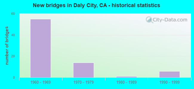
- New bridges - historical statistics
- 551960-1969
- 141970-1979
- 11980-1989
- 61990-1999

- Reconstructed bridges - Historical Statistics
- 11960-1969
- 01970-1979
- 01980-1989
- 21990-1999


- Bridge Condition - Deck
- 41.7%Good
- 33.3%Satisfactory
- 13.9%Fair
- 11.1%Poor

- Bridge Condition - Superstructure
- 30.6%Good
- 11.1%Satisfactory
- 58.3%Fair

- Bridge Condition - Substructure
- 80.6%Good
- 5.6%Satisfactory
- 13.9%Fair
Find on map >> Show street view
Structure Number: 35 0116L, Location: 04-SM-280-R24.20-DLC (Lat: 37.663403, Lng: -122.465761), Route carried "on" structure: Interstate 280, Year Built: 1967, Status: Open, Structure Length: 4.91m (16.11ft), Average Daily Traffic: 89,000 (year 2009), Truck Traffic: 1%, Average Future Daily Traffic: 127,067 (year 2038), Design Load: HS 20, Features Intersected: HICKEY BOULEVARD
Minimum Vertical Clearance: 30+ m (98+ ft), Kilometerpoint: 24.200, Lanes on structure: 4, Lanes under structure: 6, Base Highway Network: Yes (Inventory Route: 2, Subroute: 1), Owner: State Highway Agency, Approaching Roadway Width: 20.1m (65.9ft), Skew: 1 degrees, Material/Design: Concrete continuous, Design/Construction: Box Beam or Girders - Multiple, Number Of Spans In Main Unit: 2, Length of Maximum Span: 25.9m (85.0ft), Curb-To-Curb Width: 20.1m (65.9ft), Out-to-Out Width: 21.2m (69.6ft)
Condition: Deck: Good, Superstructure: Satisfactory, Substructure: Good, Operating Rating: 82.6 metric tons, Method Used To Determine Operating Rating: Load Factor (LF), Inventory Rating: 49.6 metric tons, Method Used To Determine Inventory Rating: Load Factor (LF), Structural Evaluation: Equal to present minimum criteria, Deck Geometry: Equal to present minimum criteria, Underclear: High priority of corrective action, Approach Roadway Alignment: Equal to present desirable criteria, Designated Inspection Frequency: Every 24 months, Inspection Date: Febuary 2021, Deck Structure Type: Concrete Cast-file-Place, Wearing Surface/Protective System: Wearing Surface: Monolithic Concrete
Find on map >> Show street view
Structure Number: 35 0116R, Location: 04-SM-280-R24.20-DLC (Lat: 37.663297, Lng: -122.465306), Route carried "on" structure: Interstate 280, Year Built: 1967, Status: Open, Structure Length: 4.82m (15.81ft), Average Daily Traffic: 89,000 (year 2009), Truck Traffic: 1%, Average Future Daily Traffic: 127,916 (year 2043), Design Load: HS 20, Features Intersected: HICKEY BOULEVARD
Minimum Vertical Clearance: 30+ m (98+ ft), Kilometerpoint: 24.200, Lanes on structure: 5, Lanes under structure: 6, Base Highway Network: Yes (Inventory Route: 2, Subroute: 1), Owner: State Highway Agency, Approaching Roadway Width: 24.7m (81.0ft), Skew: 1 degrees, Material/Design: Concrete continuous, Design/Construction: Box Beam or Girders - Multiple, Number Of Spans In Main Unit: 2, Length of Maximum Span: 25.0m (82.0ft), Curb-To-Curb Width: 24.7m (81.0ft), Out-to-Out Width: 25.8m (84.6ft)
Condition: Deck: Satisfactory, Superstructure: Satisfactory, Substructure: Good, Operating Rating: 84.2 metric tons, Method Used To Determine Operating Rating: Load Factor (LF), Inventory Rating: 50.5 metric tons, Method Used To Determine Inventory Rating: Load Factor (LF), Structural Evaluation: Equal to present minimum criteria, Deck Geometry: Better than present minimum criteria, Underclear: High priority of corrective action, Approach Roadway Alignment: Equal to present minimum criteria, Designated Inspection Frequency: Every 48 months, Inspection Date: Febuary 2021, Deck Structure Type: Concrete Cast-file-Place
Find on map >> Show street view
Structure Number: 35 017, Location: 04-SM-001-R43.46-PFA (Lat: 37.625758, Lng: -122.487969), Route carried "on" structure: City street D540, Year Built: 1965, Status: Open, Structure Length: 6.42m (21.06ft), Average Daily Traffic: 22,450 (year 1998), Truck Traffic: 2%, Average Future Daily Traffic: 31,959 (year 2037), Design Load: HS 20+Mod, Features Intersected: STATE ROUTE 1, Facility Carried by Structure: SHARP PARK ROAD
Minimum Vertical Clearance: 30+ m (98+ ft), Kilometerpoint: 0.000, Lanes on structure: 2, Lanes under structure: 6, Owner: State Highway Agency, Approaching Roadway Width: 13.4m (44.0ft), Material/Design: Concrete continuous, Design/Construction: Box Beam or Girders - Multiple, Number Of Spans In Main Unit: 2, Length of Maximum Span: 32.0m (105.0ft), Curb or Sidewalk Widths: Left: 0.0m, Right: 1.5m (4.9ft), Curb-To-Curb Width: 13.4m (44.0ft), Out-to-Out Width: 16.0m (52.5ft)
Condition: Deck: Satisfactory, Superstructure: Fair, Substructure: Good, Operating Rating: 37.3 metric tons, Method Used To Determine Operating Rating: Load and Resistance Factor Rating (LRFR) rating reported by rating factor(RF) method using HL-93 loadings, Inventory Rating: 28.5 metric tons, Method Used To Determine Inventory Rating: Load and Resistance Factor Rating (LRFR) rating reported by rating factor(RF) method using HL-93 loadings, Structural Evaluation: Somewhat better than minimum adequacy, Deck Geometry: Equal to present minimum criteria, Underclear: High priority of corrective action, Approach Roadway Alignment: Equal to present desirable criteria, Designated Inspection Frequency: Every 24 months, Inspection Date: October 2020, Deck Structure Type: Concrete Cast-file-Place
Find on map >> Show street view
Structure Number: 35 0172, Location: 04-SM-280-M27.17L-DLC (Lat: 37.704700, Lng: -122.472311), Route carried "on" structure: City street D005, Year Built: 1965, Year Reconstructed: 2001, Status: Open, Structure Length: 11.77m (38.62ft), Average Daily Traffic: 29,660 (year 2002), Truck Traffic: 2%, Average Future Daily Traffic: 38,197 (year 2041), Design Load: HS 20, Features Intersected: INTERSTATE 280, SR 1, Facility Carried by Structure: JOHN DALY BLVD
Minimum Vertical Clearance: 30+ m (98+ ft), Kilometerpoint: 0.000, Lanes on structure: 8, Lanes under structure: 10, Base Highway Network: Yes, Owner: State Highway Agency, Approaching Roadway Width: 18.8m (61.7ft), Skew: 22 degrees, Material/Design: Concrete continuous, Design/Construction: Box Beam or Girders - Multiple, Number Of Spans In Main Unit: 4, Length of Maximum Span: 33.5m (109.9ft), Curb or Sidewalk Widths: Left: 0.6m (2.0ft), Right: 2.1m (6.9ft), Curb-To-Curb Width: 30.1m (98.8ft), Out-to-Out Width: 34.8m (114.2ft)
Condition: Deck: Fair, Superstructure: Good, Substructure: Good, Operating Rating: 79.4 metric tons, Method Used To Determine Operating Rating: Load Factor (LF), Inventory Rating: 47.6 metric tons, Method Used To Determine Inventory Rating: Load Factor (LF), Structural Evaluation: Better than present minimum criteria, Deck Geometry: Meets minimum limits, Underclear: High priority of corrective action, Approach Roadway Alignment: Equal to present desirable criteria, Designated Inspection Frequency: Every 24 months, Inspection Date: Febuary 2021, Deck Structure Type: Concrete Cast-file-Place
Find on map >> Show street view
Structure Number: 35 0174K, Location: 04-SM-280-M27.20L-DLC (Lat: 37.705589, Lng: -122.470742), Route carried "on" structure: Ramp Interstate 280, Year Built: 1965, Status: Open, Structure Length: 16.43m (53.90ft), Average Daily Traffic: 9,600 (year 1998), Truck Traffic: 2%, Average Future Daily Traffic: 13,629 (year 2041), Design Load: HS 20, Features Intersected: INTERSTATE 280
Minimum Vertical Clearance: 30+ m (98+ ft), Kilometerpoint: 27.200, Lanes on structure: 2, Lanes under structure: 6, Base Highway Network: Yes (Inventory Route: 2, Subroute: 1), Owner: State Highway Agency, Approaching Roadway Width: 7.3m (24.0ft), Skew: 9 degrees, Material/Design: Concrete continuous, Design/Construction: Box Beam or Girders - Multiple, Number Of Spans In Main Unit: 6, Length of Maximum Span: 35.0m (114.8ft), Curb or Sidewalk Widths: Left: 0.6m (2.0ft), Right: 0.6m (2.0ft), Curb-To-Curb Width: 9.5m (31.2ft), Out-to-Out Width: 11.3m (37.1ft)
Condition: Deck: Good, Superstructure: Fair, Substructure: Good, Operating Rating: 74.8 metric tons, Method Used To Determine Operating Rating: Allowable Stress (AS), Inventory Rating: 35.3 metric tons, Method Used To Determine Inventory Rating: Allowable Stress (AS), Structural Evaluation: Somewhat better than minimum adequacy, Deck Geometry: Somewhat better than minimum adequacy, Underclear: High priority of corrective action, Approach Roadway Alignment: Equal to present minimum criteria, Designated Inspection Frequency: Every 24 months, Inspection Date: Febuary 2021, Deck Structure Type: Concrete Cast-file-Place, Wearing Surface/Protective System: Wearing Surface: Integral Concrete
Find on map >> Show street view
Structure Number: 35 0175S, Location: 04-SM-001-R48.38-DLC (Lat: 37.705558, Lng: -122.470753), Route carried "on" structure: Ramp State highway 1, Year Built: 1965, Status: Open, Structure Length: 18.59m (60.99ft), Average Daily Traffic: 6,600 (year 1998), Truck Traffic: 2%, Average Future Daily Traffic: 21,092 (year 2037), Design Load: HS 20+Mod, Features Intersected: INTERSTATE 280
Minimum Vertical Clearance: 30+ m (98+ ft), Kilometerpoint: 48.380, Lanes on structure: 2, Lanes under structure: 8, Base Highway Network: Yes, Owner: State Highway Agency, Approaching Roadway Width: 8.5m (27.9ft), Material/Design: Concrete continuous, Design/Construction: Box Beam or Girders - Multiple, Number Of Spans In Main Unit: 7, Length of Maximum Span: 33.5m (109.9ft), Curb or Sidewalk Widths: Left: 0.6m (2.0ft), Right: 0.6m (2.0ft), Curb-To-Curb Width: 8.5m (27.9ft), Out-to-Out Width: 10.4m (34.1ft)
Condition: Deck: Good, Superstructure: Good, Substructure: Satisfactory, Operating Rating: 99.8 metric tons, Method Used To Determine Operating Rating: Load Factor (LF), Inventory Rating: 85.2 metric tons, Method Used To Determine Inventory Rating: Load Factor (LF), Structural Evaluation: Equal to present minimum criteria, Deck Geometry: High priority of corrective action, Underclear: Meets minimum limits, Approach Roadway Alignment: Equal to present minimum criteria, Designated Inspection Frequency: Every 24 months, Inspection Date: October 2020, Deck Structure Type: Concrete Cast-file-Place, Wearing Surface/Protective System: Wearing Surface: Integral Concrete
Find on map >> Show street view
Structure Number: 35 0176, Location: 04-SM-280-M27.41L-DLC (Lat: 37.708383, Lng: -122.469278), Route carried "on" structure: City street , Year Built: 1965, Status: Open, Structure Length: 8.35m (27.40ft), Average Daily Traffic: 15,000 (year 2004), Truck Traffic: 2%, Average Future Daily Traffic: 19,368 (year 2041), Design Load: HS 20, Features Intersected: INTERSTATE 280, Facility Carried by Structure: ST CHARLES AVENUE
Minimum Vertical Clearance: 30+ m (98+ ft), Kilometerpoint: 0.000, Lanes on structure: 2, Lanes under structure: 8, Base Highway Network: Yes, Owner: State Highway Agency, Approaching Roadway Width: 8.4m (27.6ft), Material/Design: Concrete continuous, Design/Construction: Box Beam or Girders - Multiple, Number Of Spans In Main Unit: 4, Length of Maximum Span: 27.1m (88.9ft), Curb or Sidewalk Widths: Left: 2.1m (6.9ft), Right: 0.0m, Curb-To-Curb Width: 8.4m (27.6ft), Out-to-Out Width: 12.0m (39.4ft)
Condition: Deck: Satisfactory, Superstructure: Fair, Substructure: Good, Operating Rating: 50.9 metric tons, Method Used To Determine Operating Rating: Load and Resistance Factor Rating (LRFR) rating reported by rating factor(RF) method using HL-93 loadings, Inventory Rating: 39.2 metric tons, Method Used To Determine Inventory Rating: Load and Resistance Factor Rating (LRFR) rating reported by rating factor(RF) method using HL-93 loadings, Structural Evaluation: Somewhat better than minimum adequacy, Deck Geometry: High priority of corrective action, Underclear: Meets minimum limits, Approach Roadway Alignment: Equal to present minimum criteria, Designated Inspection Frequency: Every 24 months, Inspection Date: Febuary 2021, Deck Structure Type: Concrete Cast-file-Place
Find on map >> Show street view
Structure Number: 35 0178, Location: 04-SM-280-R25.04-DLC (Lat: 37.674978, Lng: -122.469019), Route carried "on" structure: Interstate 280, Year Built: 1967, Status: Open, Structure Length: 5.64m (18.50ft), Average Daily Traffic: 178,000 (year 2009), Truck Traffic: 1%, Average Future Daily Traffic: 256,684 (year 2041), Design Load: H 20, Features Intersected: SOUTHGATE AVENUE
Minimum Vertical Clearance: 30+ m (98+ ft), Kilometerpoint: 25.040, Lanes on structure: 11, Lanes under structure: 4, Base Highway Network: Yes (Inventory Route: 2, Subroute: 1), Owner: State Highway Agency, Approaching Roadway Width: 52.4m (171.9ft), Skew: 39 degrees, Material/Design: Concrete continuous, Design/Construction: Box Beam or Girders - Multiple, Number Of Spans In Main Unit: 3, Length of Maximum Span: 27.9m (91.5ft), Curb-To-Curb Width: 52.4m (171.9ft), Out-to-Out Width: 54.7m (179.5ft)
Condition: Deck: Poor, Superstructure: Fair, Substructure: Good, Operating Rating: 88.5 metric tons, Method Used To Determine Operating Rating: Load Factor (LF), Inventory Rating: 53.1 metric tons, Method Used To Determine Inventory Rating: Load Factor (LF), Structural Evaluation: Somewhat better than minimum adequacy, Deck Geometry: Superior to present desirable criteria, Underclear: Meets minimum limits, Approach Roadway Alignment: Equal to present desirable criteria, Length Of Structure Improvement: 5.64m (18.50ft), Designated Inspection Frequency: Every 24 months, Inspection Date: Febuary 2021, Bridge Improvement Cost: $3,085,000, Roadway Improvement Cost: $617,000, Total Project Cost: $5,182,000 ( Estimate for 2020), Deck Structure Type: Concrete Cast-file-Place
Find on map >> Show street view
Structure Number: 35 0179G, Location: 04-SM-280-R25.26-DLC (Lat: 37.677264, Lng: -122.472686), Route carried "on" structure: Ramp Interstate 280, Year Built: 1967, Status: Open, Structure Length: 19.84m (65.09ft), Average Daily Traffic: 8,600 (year 1998), Truck Traffic: 2%, Average Future Daily Traffic: 28,132 (year 2041), Design Load: HS 20+Mod, Features Intersected: I 280, SR 1, & CONNS
Minimum Vertical Clearance: 30+ m (98+ ft), Kilometerpoint: 25.260, Lanes on structure: 1, Lanes under structure: 16, Base Highway Network: Yes, Owner: State Highway Agency, Approaching Roadway Width: 7.3m (24.0ft), Material/Design: Concrete continuous, Design/Construction: Box Beam or Girders - Multiple, Number Of Spans In Main Unit: 6, Length of Maximum Span: 38.1m (125.0ft), Curb-To-Curb Width: 7.3m (24.0ft), Out-to-Out Width: 8.4m (27.6ft)
Condition: Deck: Fair, Superstructure: Fair, Substructure: Good, Operating Rating: 75.2 metric tons, Method Used To Determine Operating Rating: Load Factor (LF), Inventory Rating: 45.0 metric tons, Method Used To Determine Inventory Rating: Load Factor (LF), Structural Evaluation: Somewhat better than minimum adequacy, Deck Geometry: Better than present minimum criteria, Underclear: High priority of corrective action, Approach Roadway Alignment: Equal to present minimum criteria, Designated Inspection Frequency: Every 24 months, Inspection Date: Febuary 2021, Deck Structure Type: Concrete Cast-file-Place
Find on map >> Show street view
Structure Number: 35 0181, Location: 04-SM-280-R25.78-DLC (Lat: 37.684556, Lng: -122.472008), Route carried "on" structure: City street D594, Year Built: 1965, Status: Open, Structure Length: 13.60m (44.62ft), Average Daily Traffic: 25,000 (year 2005), Truck Traffic: 3%, Average Future Daily Traffic: 32,388 (year 2043), Design Load: HS 20, Features Intersected: INTERSTATE 280, Facility Carried by Structure: SAN PEDRO ROAD
Minimum Vertical Clearance: 30+ m (98+ ft), Kilometerpoint: 0.000, Lanes on structure: 5, Lanes under structure: 12, Base Highway Network: Yes, Owner: State Highway Agency, Approaching Roadway Width: 15.8m (51.8ft), Skew: 5 degrees, Material/Design: Concrete continuous, Design/Construction: Box Beam or Girders - Multiple, Number Of Spans In Main Unit: 4, Length of Maximum Span: 47.3m (155.2ft), Curb or Sidewalk Widths: Left: 1.5m (4.9ft), Right: 1.5m (4.9ft), Curb-To-Curb Width: 15.8m (51.8ft), Out-to-Out Width: 19.5m (64.0ft)
Condition: Deck: Fair, Superstructure: Fair, Substructure: Good, Operating Rating: 48.0 metric tons, Method Used To Determine Operating Rating: Load and Resistance Factor Rating (LRFR) rating reported by rating factor(RF) method using HL-93 loadings, Inventory Rating: 34.7 metric tons, Method Used To Determine Inventory Rating: Load and Resistance Factor Rating (LRFR) rating reported by rating factor(RF) method using HL-93 loadings, Structural Evaluation: Somewhat better than minimum adequacy, Deck Geometry: High priority of replacement, Underclear: Equal to present minimum criteria, Approach Roadway Alignment: Equal to present desirable criteria, Designated Inspection Frequency: Every 24 months, Inspection Date: Febuary 2021, Deck Structure Type: Concrete Cast-file-Place
Find on map >> Show street view
Structure Number: 35 0182, Location: 04-SM-280-R26.04-DLC (Lat: 37.689306, Lng: -122.471014), Route carried "on" structure: City street D022, Year Built: 1965, Status: Open, Structure Length: 11.07m (36.32ft), Average Daily Traffic: 29,300 (year 2002), Truck Traffic: 2%, Average Future Daily Traffic: 38,197 (year 2041), Design Load: HS 20, Features Intersected: INTERSTATE 280, Facility Carried by Structure: JUNIPERO SERRA BL
Minimum Vertical Clearance: 30+ m (98+ ft), Kilometerpoint: 0.000, Lanes on structure: 4, Lanes under structure: 13, Base Highway Network: Yes, Owner: State Highway Agency, Approaching Roadway Width: 15.8m (51.8ft), Skew: 9 degrees, Material/Design: Concrete continuous, Design/Construction: Box Beam or Girders - Multiple, Number Of Spans In Main Unit: 3, Length of Maximum Span: 44.2m (145.0ft), Curb or Sidewalk Widths: Left: 0.6m (2.0ft), Right: 2.4m (7.9ft), Curb-To-Curb Width: 15.8m (51.8ft), Out-to-Out Width: 19.5m (64.0ft)
Condition: Deck: Good, Superstructure: Fair, Substructure: Satisfactory, Operating Rating: 70.3 metric tons, Method Used To Determine Operating Rating: Load Factor (LF), Inventory Rating: 42.1 metric tons, Method Used To Determine Inventory Rating: Load Factor (LF), Structural Evaluation: Somewhat better than minimum adequacy, Deck Geometry: Meets minimum limits, Underclear: Somewhat better than minimum adequacy, Approach Roadway Alignment: Equal to present desirable criteria, Designated Inspection Frequency: Every 24 months, Inspection Date: Febuary 2021, Deck Structure Type: Concrete Cast-file-Place
Find on map >> Show street view
Structure Number: 35 0183, Location: 04-SM-280-R26.35-DLC (Lat: 37.693233, Lng: -122.470775), Route carried "on" structure: City street D596, Year Built: 1965, Status: Open, Structure Length: 6.40m (21.00ft), Average Daily Traffic: 7,320 (year 2002), Truck Traffic: 2%, Average Future Daily Traffic: 9,453 (year 2041), Design Load: HS 20, Features Intersected: INTERSTATE 280, Facility Carried by Structure: SCHOOL STREET
Minimum Vertical Clearance: 30+ m (98+ ft), Kilometerpoint: 0.000, Lanes on structure: 3, Lanes under structure: 13, Owner: State Highway Agency, Approaching Roadway Width: 12.2m (40.0ft), Material/Design: Concrete continuous, Design/Construction: Box Beam or Girders - Multiple, Number Of Spans In Main Unit: 2, Length of Maximum Span: 33.9m (111.2ft), Curb or Sidewalk Widths: Left: 1.5m (4.9ft), Right: 1.5m (4.9ft), Curb-To-Curb Width: 12.2m (40.0ft), Out-to-Out Width: 15.9m (52.2ft)
Condition: Deck: Satisfactory, Superstructure: Fair, Substructure: Good, Operating Rating: 46.7 metric tons, Method Used To Determine Operating Rating: Load and Resistance Factor Rating (LRFR) rating reported by rating factor(RF) method using HL-93 loadings, Inventory Rating: 36.0 metric tons, Method Used To Determine Inventory Rating: Load and Resistance Factor Rating (LRFR) rating reported by rating factor(RF) method using HL-93 loadings, Structural Evaluation: Somewhat better than minimum adequacy, Deck Geometry: Meets minimum limits, Underclear: Meets minimum limits, Approach Roadway Alignment: Equal to present desirable criteria, Designated Inspection Frequency: Every 24 months, Inspection Date: Febuary 2021, Deck Structure Type: Concrete Cast-file-Place
Find on map >> Show street view
Structure Number: 35 0184, Location: 04-SM-280-R26.50-DLC (Lat: 37.695111, Lng: -122.470914), Route carried "on" structure: City street D022, Year Built: 1965, Status: Open, Structure Length: 10.06m (33.01ft), Average Daily Traffic: 29,300 (year 2002), Truck Traffic: 2%, Average Future Daily Traffic: 38,197 (year 2041), Design Load: HS 20, Features Intersected: INTERSTATE 280, Facility Carried by Structure: JUNIPERO SERRA BLV
Minimum Vertical Clearance: 30+ m (98+ ft), Kilometerpoint: 0.000, Lanes on structure: 3, Lanes under structure: 12, Base Highway Network: Yes, Owner: State Highway Agency, Approaching Roadway Width: 15.8m (51.8ft), Skew: 5 degrees, Material/Design: Concrete continuous, Design/Construction: Box Beam or Girders - Multiple, Number Of Spans In Main Unit: 3, Length of Maximum Span: 42.1m (138.1ft), Curb or Sidewalk Widths: Left: 3.0m (9.8ft), Right: 0.6m (2.0ft), Curb-To-Curb Width: 15.8m (51.8ft), Out-to-Out Width: 20.1m (65.9ft)
Condition: Deck: Satisfactory, Superstructure: Fair, Substructure: Good, Operating Rating: 85.9 metric tons, Method Used To Determine Operating Rating: Load Factor (LF), Inventory Rating: 51.8 metric tons, Method Used To Determine Inventory Rating: Load Factor (LF), Structural Evaluation: Somewhat better than minimum adequacy, Deck Geometry: Better than present minimum criteria, Underclear: Somewhat better than minimum adequacy, Approach Roadway Alignment: Equal to present desirable criteria, Designated Inspection Frequency: Every 24 months, Inspection Date: Febuary 2021, Deck Structure Type: Concrete Cast-file-Place
Find on map >> Show street view
Structure Number: 35 0185, Location: 04-SM-280-R25.97-DLC (Lat: 37.687822, Lng: -122.471531), Route carried "on" structure: City street D595, Year Built: 1965, Status: Open, Structure Length: 7.88m (25.85ft), Average Daily Traffic: 4,080 (year 2002), Truck Traffic: 2%, Average Future Daily Traffic: 5,379 (year 2041), Design Load: HS 20, Features Intersected: INTERSTATE 280, Facility Carried by Structure: WASHINGTON STREET
Minimum Vertical Clearance: 30+ m (98+ ft), Kilometerpoint: 0.000, Lanes on structure: 4, Lanes under structure: 14, Owner: State Highway Agency, Approaching Roadway Width: 15.8m (51.8ft), Skew: 1 degrees, Material/Design: Concrete continuous, Design/Construction: Box Beam or Girders - Multiple, Number Of Spans In Main Unit: 3, Length of Maximum Span: 31.2m (102.4ft), Curb or Sidewalk Widths: Left: 0.6m (2.0ft), Right: 1.5m (4.9ft), Curb-To-Curb Width: 15.8m (51.8ft), Out-to-Out Width: 18.6m (61.0ft)
Condition: Deck: Good, Superstructure: Satisfactory, Substructure: Good, Operating Rating: 45.0 metric tons, Method Used To Determine Operating Rating: Load and Resistance Factor Rating (LRFR) rating reported by rating factor(RF) method using HL-93 loadings, Inventory Rating: 34.3 metric tons, Method Used To Determine Inventory Rating: Load and Resistance Factor Rating (LRFR) rating reported by rating factor(RF) method using HL-93 loadings, Structural Evaluation: Equal to present minimum criteria, Deck Geometry: Meets minimum limits, Underclear: Somewhat better than minimum adequacy, Approach Roadway Alignment: Equal to present desirable criteria, Designated Inspection Frequency: Every 24 months, Inspection Date: Febuary 2021, Deck Structure Type: Concrete Cast-file-Place
Find on map >> Show street view
Structure Number: 35 0186K, Location: 04-SM-280-R25.34-DLC (Lat: 37.678356, Lng: -122.471986), Route carried "on" structure: Ramp Interstate 280, Year Built: 1967, Status: Open, Structure Length: 10.20m (33.46ft), Average Daily Traffic: 8,600 (year 2002), Truck Traffic: 2%, Average Future Daily Traffic: 27,041 (year 2041), Design Load: HS 20, Features Intersected: S280-S1 CONNECTOR RAMP
Minimum Vertical Clearance: 30+ m (98+ ft), Kilometerpoint: 25.340, Lanes on structure: 1, Lanes under structure: 3, Owner: State Highway Agency, Approaching Roadway Width: 7.3m (24.0ft), Skew: 9 degrees, Material/Design: Concrete continuous, Design/Construction: Box Beam or Girders - Multiple, Number Of Spans In Main Unit: 3, Length of Maximum Span: 43.1m (141.4ft), Curb-To-Curb Width: 7.3m (24.0ft), Out-to-Out Width: 8.4m (27.6ft)
Condition: Deck: Satisfactory, Superstructure: Fair, Substructure: Good, Operating Rating: 60.3 metric tons, Method Used To Determine Operating Rating: Load Factor (LF), Inventory Rating: 36.3 metric tons, Method Used To Determine Inventory Rating: Load Factor (LF), Structural Evaluation: Somewhat better than minimum adequacy, Deck Geometry: Better than present minimum criteria, Underclear: Somewhat better than minimum adequacy, Approach Roadway Alignment: Equal to present minimum criteria, Designated Inspection Frequency: Every 24 months, Inspection Date: Febuary 2021, Deck Structure Type: Concrete Cast-file-Place
Find on map >> Show street view
Structure Number: 35 0192, Location: 04-SM-001-R46.51-DLC (Lat: 37.665503, Lng: -122.485214), Route carried "on" structure: State highway 1, Year Built: 1964, Year Reconstructed: 1972, Status: Open, Structure Length: 4.14m (13.58ft), Average Daily Traffic: 43,500 (year 2009), Truck Traffic: 2%, Average Future Daily Traffic: 62,847 (year 2035), Design Load: HS 20, Features Intersected: GATEWAY DRIVE
Minimum Vertical Clearance: 30+ m (98+ ft), Kilometerpoint: 46.510, Lanes on structure: 8, Lanes under structure: 2, Base Highway Network: Yes (, Subroute: 1), Owner: State Highway Agency, Approaching Roadway Width: 53.2m (174.5ft), Skew: 30 degrees, Material/Design: Concrete continuous, Design/Construction: Box Beam or Girders - Multiple, Number Of Spans In Main Unit: 3, Length of Maximum Span: 18.9m (62.0ft), Curb-To-Curb Width: 53.2m (174.5ft), Out-to-Out Width: 57.0m (187.0ft)
Condition: Deck: Good, Superstructure: Good, Substructure: Good, Operating Rating: 43.1 metric tons, Method Used To Determine Operating Rating: Load and Resistance Factor Rating (LRFR) rating reported by rating factor(RF) method using HL-93 loadings, Inventory Rating: 33.4 metric tons, Method Used To Determine Inventory Rating: Load and Resistance Factor Rating (LRFR) rating reported by rating factor(RF) method using HL-93 loadings, Structural Evaluation: Better than present minimum criteria, Deck Geometry: Superior to present desirable criteria, Underclear: Somewhat better than minimum adequacy, Approach Roadway Alignment: Equal to present desirable criteria, Designated Inspection Frequency: Every 48 months, Inspection Date: October 2018, Deck Structure Type: Concrete Cast-file-Place, Wearing Surface/Protective System: Wearing Surface: Bituminous
Find on map >> Show street view
Structure Number: 35 0200G, Location: 04-SM-035-L23.00-SBR (Lat: 37.604272, Lng: -122.427325), Route carried "on" structure: Ramp State highway 35, Year Built: 1967, Status: Open, Structure Length: 11.28m (37.01ft), Average Daily Traffic: 5,600 (year 2005), Truck Traffic: 2%, Average Future Daily Traffic: 7,482 (year 2038), Design Load: HS 20+Mod, Features Intersected: INTERSTATE 280
Minimum Vertical Clearance: 30+ m (98+ ft), Kilometerpoint: 23.000, Lanes on structure: 2, Lanes under structure: 8, Owner: State Highway Agency, Approaching Roadway Width: 11.3m (37.1ft), Skew: 5 degrees, Material/Design: Prestressed concrete continuous, Design/Construction: Box Beam or Girders - Multiple, Number Of Spans In Main Unit: 2, Length of Maximum Span: 58.7m (192.6ft), Curb-To-Curb Width: 11.3m (37.1ft), Out-to-Out Width: 12.4m (40.7ft)
Condition: Deck: Good, Superstructure: Fair, Substructure: Fair, Operating Rating: 99.8 metric tons, Method Used To Determine Operating Rating: Load Factor (LF), Inventory Rating: 32.4 metric tons, Method Used To Determine Inventory Rating: Load Factor (LF), Structural Evaluation: Somewhat better than minimum adequacy, Deck Geometry: Superior to present desirable criteria, Underclear: Equal to present minimum criteria, Approach Roadway Alignment: Equal to present minimum criteria, Designated Inspection Frequency: Every 24 months, Inspection Date: July 2021, Deck Structure Type: Concrete Cast-file-Place
Find on map >> Show street view
Structure Number: 35 0202L, Location: 04-SM-280-R23.16-DLC (Lat: 37.651933, Lng: -122.453933), Route carried "on" structure: Interstate 280, Year Built: 1967, Status: Open, Structure Length: 4.84m (15.88ft), Average Daily Traffic: 89,000 (year 2009), Truck Traffic: 1%, Average Future Daily Traffic: 127,067 (year 2038), Design Load: HS 20, Features Intersected: KING DRIVE
Minimum Vertical Clearance: 30+ m (98+ ft), Kilometerpoint: 23.160, Lanes on structure: 4, Lanes under structure: 2, Base Highway Network: Yes (Inventory Route: 2, Subroute: 1), Owner: State Highway Agency, Approaching Roadway Width: 20.1m (65.9ft), Material/Design: Concrete continuous, Design/Construction: Box Beam or Girders - Multiple, Number Of Spans In Main Unit: 2, Length of Maximum Span: 25.8m (84.6ft), Curb-To-Curb Width: 20.1m (65.9ft), Out-to-Out Width: 21.2m (69.6ft)
Condition: Deck: Fair, Superstructure: Fair, Substructure: Good, Operating Rating: 53.5 metric tons, Method Used To Determine Operating Rating: Load and Resistance Factor Rating (LRFR) rating reported by rating factor(RF) method using HL-93 loadings, Inventory Rating: 41.1 metric tons, Method Used To Determine Inventory Rating: Load and Resistance Factor Rating (LRFR) rating reported by rating factor(RF) method using HL-93 loadings, Structural Evaluation: Somewhat better than minimum adequacy, Deck Geometry: Equal to present minimum criteria, Underclear: High priority of corrective action, Approach Roadway Alignment: Equal to present desirable criteria, Designated Inspection Frequency: Every 24 months, Inspection Date: Febuary 2021, Deck Structure Type: Concrete Cast-file-Place
Find on map >> Show street view
Structure Number: 35 0202R, Location: 04-SM-280-R23.16-DLC (Lat: 37.652125, Lng: -122.453669), Route carried "on" structure: Interstate 280, Year Built: 1967, Status: Open, Structure Length: 4.24m (13.91ft), Average Daily Traffic: 89,000 (year 2009), Truck Traffic: 1%, Average Future Daily Traffic: 127,067 (year 2038), Design Load: HS 20, Features Intersected: KING DRIVE
Minimum Vertical Clearance: 30+ m (98+ ft), Kilometerpoint: 23.160, Lanes on structure: 4, Lanes under structure: 3, Base Highway Network: Yes (Inventory Route: 2, Subroute: 1), Owner: State Highway Agency, Approaching Roadway Width: 20.1m (65.9ft), Material/Design: Concrete continuous, Design/Construction: Box Beam or Girders - Multiple, Number Of Spans In Main Unit: 2, Length of Maximum Span: 22.7m (74.5ft), Curb-To-Curb Width: 23.8m (78.1ft), Out-to-Out Width: 24.9m (81.7ft)
Condition: Deck: Good, Superstructure: Fair, Substructure: Good, Operating Rating: 46.0 metric tons, Method Used To Determine Operating Rating: Load and Resistance Factor Rating (LRFR) rating reported by rating factor(RF) method using HL-93 loadings, Inventory Rating: 35.6 metric tons, Method Used To Determine Inventory Rating: Load and Resistance Factor Rating (LRFR) rating reported by rating factor(RF) method using HL-93 loadings, Structural Evaluation: Somewhat better than minimum adequacy, Deck Geometry: Superior to present desirable criteria, Underclear: High priority of corrective action, Approach Roadway Alignment: Equal to present desirable criteria, Designated Inspection Frequency: Every 24 months, Inspection Date: Febuary 2021, Deck Structure Type: Concrete Cast-file-Place, Wearing Surface/Protective System: Wearing Surface: Integral Concrete
Find on map >> Show street view
Structure Number: 35 0204F, Location: 04-SM-001-R46.65-DLC (Lat: 37.667061, Lng: -122.484986), Route carried "on" structure: Ramp State highway 1, Year Built: 1972, Status: Open, Structure Length: 10.91m (35.79ft), Average Daily Traffic: 7,500 (year 1998), Truck Traffic: 3%, Average Future Daily Traffic: 10,202 (year 2037), Design Load: HS 20, Features Intersected: STATE ROUTE 1
Minimum Vertical Clearance: 30+ m (98+ ft), Kilometerpoint: 46.650, Lanes on structure: 2, Lanes under structure: 6, Base Highway Network: Yes (, Subroute: 1), Owner: State Highway Agency, Approaching Roadway Width: 11.9m (39.0ft), Skew: 6 degrees, Material/Design: Prestressed concrete continuous, Design/Construction: Box Beam or Girders - Multiple, Number Of Spans In Main Unit: 2, Length of Maximum Span: 54.9m (180.1ft), Curb-To-Curb Width: 11.9m (39.0ft), Out-to-Out Width: 12.5m (41.0ft)
Condition: Deck: Good, Superstructure: Good, Substructure: Fair, Operating Rating: 71.9 metric tons, Method Used To Determine Operating Rating: Load Factor (LF), Inventory Rating: 32.4 metric tons, Method Used To Determine Inventory Rating: Load Factor (LF), Structural Evaluation: Somewhat better than minimum adequacy, Deck Geometry: Superior to present desirable criteria, Underclear: Meets minimum limits, Approach Roadway Alignment: Equal to present minimum criteria, Designated Inspection Frequency: Every 24 months, Inspection Date: October 2020, Deck Structure Type: Concrete Cast-file-Place
Find on map >> Show street view
Structure Number: 35 0205L, Location: 04-SM-035-R28.66-DLC (Lat: 37.668108, Lng: -122.484667), Route carried "on" structure: State highway 35, Year Built: 1972, Status: Open, Structure Length: 11.34m (37.20ft), Average Daily Traffic: 14,750 (year 2009), Truck Traffic: 1%, Average Future Daily Traffic: 28,558 (year 2037), Design Load: HS 20, Features Intersected: NB & SB RTE 1 AND RAMPS
Minimum Vertical Clearance: 30+ m (98+ ft), Kilometerpoint: 28.660, Lanes on structure: 3, Lanes under structure: 11, Base Highway Network: Yes (, Subroute: 14), Owner: State Highway Agency, Approaching Roadway Width: 17.8m (58.4ft), Skew: 2 degrees, Material/Design: Concrete continuous, Design/Construction: Box Beam or Girders - Multiple, Number Of Spans In Main Unit: 4, Length of Maximum Span: 37.1m (121.7ft), Curb-To-Curb Width: 17.8m (58.4ft), Out-to-Out Width: 18.4m (60.4ft)
Condition: Deck: Satisfactory, Superstructure: Fair, Substructure: Good, Operating Rating: 96.9 metric tons, Method Used To Determine Operating Rating: Load Factor (LF), Inventory Rating: 58.3 metric tons, Method Used To Determine Inventory Rating: Load Factor (LF), Structural Evaluation: Somewhat better than minimum adequacy, Deck Geometry: Superior to present desirable criteria, Underclear: Meets minimum limits, Approach Roadway Alignment: Equal to present desirable criteria, Designated Inspection Frequency: Every 24 months, Inspection Date: October 2020, Deck Structure Type: Concrete Cast-file-Place
Find on map >> Show street view
Structure Number: 35 0205R, Location: 04-SM-035-R28.66-DLC (Lat: 37.668411, Lng: -122.484536), Route carried "on" structure: State highway 35, Year Built: 1972, Status: Open, Structure Length: 10.82m (35.50ft), Average Daily Traffic: 14,750 (year 2009), Truck Traffic: 1%, Average Future Daily Traffic: 28,558 (year 2037), Design Load: HS 20, Features Intersected: NB & SB RTE 1 AND RAMPS
Minimum Vertical Clearance: 30+ m (98+ ft), Kilometerpoint: 28.660, Lanes on structure: 3, Lanes under structure: 11, Base Highway Network: Yes (, Subroute: 14), Owner: State Highway Agency, Approaching Roadway Width: 14.6m (47.9ft), Skew: 1 degrees, Material/Design: Concrete continuous, Design/Construction: Box Beam or Girders - Multiple, Number Of Spans In Main Unit: 4, Length of Maximum Span: 35.7m (117.1ft), Curb-To-Curb Width: 19.2m (63.0ft), Out-to-Out Width: 19.8m (65.0ft)
Condition: Deck: Good, Superstructure: Fair, Substructure: Good, Operating Rating: 61.6 metric tons, Method Used To Determine Operating Rating: Load Factor (LF), Inventory Rating: 36.9 metric tons, Method Used To Determine Inventory Rating: Load Factor (LF), Structural Evaluation: Somewhat better than minimum adequacy, Deck Geometry: Superior to present desirable criteria, Underclear: Meets minimum limits, Approach Roadway Alignment: Equal to present desirable criteria, Designated Inspection Frequency: Every 24 months, Inspection Date: October 2020, Deck Structure Type: Concrete Cast-file-Place
Find on map >> Show street view
Structure Number: 35 0206, Location: 04-SM-001-R46.86-DLC (Lat: 37.669858, Lng: -122.483258), Route carried "on" structure: State highway 1, Year Built: 1972, Status: Open, Structure Length: 5.44m (17.85ft), Average Daily Traffic: 65,000 (year 2009), Truck Traffic: 2%, Average Future Daily Traffic: 96,420 (year 2037), Design Load: HS 20, Features Intersected: LAKESHIRE DRIVE
Minimum Vertical Clearance: 30+ m (98+ ft), Kilometerpoint: 46.860, Lanes on structure: 9, Lanes under structure: 2, Base Highway Network: Yes (, Subroute: 1), Owner: State Highway Agency, Approaching Roadway Width: 50.8m (166.7ft), Skew: 30 degrees, Material/Design: Prestressed concrete, Design/Construction: Box Beam or Girders - Multiple, Number Of Spans In Main Unit: 1, Length of Maximum Span: 54.4m (178.5ft), Curb-To-Curb Width: 50.8m (166.7ft), Out-to-Out Width: 55.5m (182.1ft)
Condition: Deck: Good, Superstructure: Good, Substructure: Good, Operating Rating: 99.5 metric tons, Method Used To Determine Operating Rating: Load Factor (LF), Inventory Rating: 32.4 metric tons, Method Used To Determine Inventory Rating: Load Factor (LF), Structural Evaluation: Better than present minimum criteria, Deck Geometry: Superior to present desirable criteria, Underclear: Equal to present minimum criteria, Approach Roadway Alignment: Equal to present desirable criteria, Designated Inspection Frequency: Every 24 months, Inspection Date: October 2020, Deck Structure Type: Concrete Cast-file-Place
Find on map >> Show street view
Structure Number: 35 0206G, Location: 04-SM-035-R28.64-DLC (Lat: 37.669700, Lng: -122.483078), Route carried "on" structure: Ramp State highway 35, Year Built: 1972, Status: Open, Structure Length: 3.66m (12.01ft), Average Daily Traffic: 7,300 (year 1998), Truck Traffic: 2%, Average Future Daily Traffic: 23,330 (year 2037), Design Load: HS 20, Features Intersected: LAKESHIRE DRIVE
Minimum Vertical Clearance: 30+ m (98+ ft), Kilometerpoint: 28.640, Lanes on structure: 2, Lanes under structure: 2, Base Highway Network: Yes (, Subroute: 1), Owner: State Highway Agency, Approaching Roadway Width: 11.9m (39.0ft), Skew: 9 degrees, Material/Design: Prestressed concrete, Design/Construction: Box Beam or Girders - Multiple, Number Of Spans In Main Unit: 1, Length of Maximum Span: 36.0m (118.1ft), Curb-To-Curb Width: 11.9m (39.0ft), Out-to-Out Width: 12.5m (41.0ft)
Condition: Deck: Good, Superstructure: Good, Substructure: Good, Operating Rating: 90.4 metric tons, Method Used To Determine Operating Rating: Load Factor (LF), Inventory Rating: 32.4 metric tons, Method Used To Determine Inventory Rating: Load Factor (LF), Structural Evaluation: Better than present minimum criteria, Deck Geometry: Superior to present desirable criteria, Underclear: Somewhat better than minimum adequacy, Approach Roadway Alignment: Equal to present minimum criteria, Designated Inspection Frequency: Every 24 months, Inspection Date: October 2020, Deck Structure Type: Concrete Cast-file-Place
Find on map >> Show street view
Structure Number: 35 0209L, Location: 04-SM-280-R24.63-DLC (Lat: 37.669558, Lng: -122.466133), Route carried "on" structure: Interstate 280, Year Built: 1967, Status: Open, Structure Length: 4.42m (14.50ft), Average Daily Traffic: 89,000 (year 2009), Truck Traffic: 1%, Average Future Daily Traffic: 127,067 (year 2038), Design Load: HS 20, Features Intersected: SERRAMONTE BOULEVARD
Minimum Vertical Clearance: 30+ m (98+ ft), Kilometerpoint: 24.630, Lanes on structure: 4, Lanes under structure: 6, Base Highway Network: Yes (Inventory Route: 2, Subroute: 1), Owner: State Highway Agency, Approaching Roadway Width: 20.1m (65.9ft), Skew: 1 degrees, Material/Design: Concrete continuous, Design/Construction: Box Beam or Girders - Multiple, Number Of Spans In Main Unit: 2, Length of Maximum Span: 23.8m (78.1ft), Curb-To-Curb Width: 20.1m (65.9ft), Out-to-Out Width: 21.2m (69.6ft)
Condition: Deck: Poor, Superstructure: Fair, Substructure: Good, Operating Rating: 72.6 metric tons, Method Used To Determine Operating Rating: Load Factor (LF), Inventory Rating: 43.4 metric tons, Method Used To Determine Inventory Rating: Load Factor (LF), Structural Evaluation: Somewhat better than minimum adequacy, Deck Geometry: Equal to present minimum criteria, Underclear: Meets minimum limits, Approach Roadway Alignment: Equal to present desirable criteria, Length Of Structure Improvement: 4.42m (14.50ft), Designated Inspection Frequency: Every 24 months, Inspection Date: Febuary 2021, Bridge Improvement Cost: $937,000, Roadway Improvement Cost: $187,000, Total Project Cost: $1,574,000 ( Estimate for 2020), Deck Structure Type: Concrete Cast-file-Place
Find on map >> Show street view
Structure Number: 35 0209R, Location: 04-SM-280-R24.63-DLC (Lat: 37.669714, Lng: -122.465786), Route carried "on" structure: Interstate 280, Year Built: 1967, Status: Open, Structure Length: 3.93m (12.89ft), Average Daily Traffic: 89,000 (year 2009), Truck Traffic: 1%, Average Future Daily Traffic: 127,067 (year 2038), Design Load: HS 20, Features Intersected: SERRAMONTE BOULEVARD
Minimum Vertical Clearance: 30+ m (98+ ft), Kilometerpoint: 24.630, Lanes on structure: 4, Lanes under structure: 6, Base Highway Network: Yes (Inventory Route: 2, Subroute: 1), Owner: State Highway Agency, Approaching Roadway Width: 21.0m (68.9ft), Skew: 1 degrees, Material/Design: Concrete continuous, Design/Construction: Box Beam or Girders - Multiple, Number Of Spans In Main Unit: 2, Length of Maximum Span: 21.3m (69.9ft), Curb-To-Curb Width: 20.1m (65.9ft), Out-to-Out Width: 21.2m (69.6ft)
Condition: Deck: Poor, Superstructure: Fair, Substructure: Good, Operating Rating: 54.8 metric tons, Method Used To Determine Operating Rating: Load Factor (LF), Inventory Rating: 32.7 metric tons, Method Used To Determine Inventory Rating: Load Factor (LF), Structural Evaluation: Somewhat better than minimum adequacy, Deck Geometry: Equal to present minimum criteria, Underclear: Meets minimum limits, Approach Roadway Alignment: Equal to present desirable criteria, Length Of Structure Improvement: 3.93m (12.89ft), Designated Inspection Frequency: Every 24 months, Inspection Date: Febuary 2021, Bridge Improvement Cost: $833,000, Roadway Improvement Cost: $166,000, Total Project Cost: $1,399,000 ( Estimate for 2020), Deck Structure Type: Concrete Cast-file-Place
Find on map >> Show street view
Structure Number: 35 0230L, Location: 04-SM-280-R4.65-WDS (Lat: 37.443697, Lng: -122.263236), Route carried "on" structure: Interstate 280, Year Built: 1969, Status: Open, Structure Length: 7.46m (24.48ft), Average Daily Traffic: 50,000 (year 2009), Truck Traffic: 3%, Average Future Daily Traffic: 67,586 (year 2038), Design Load: HS 20, Features Intersected: FARM HILL BOULEVARD
Minimum Vertical Clearance: 30+ m (98+ ft), Kilometerpoint: 4.650, Lanes on structure: 4, Lanes under structure: 4, Base Highway Network: Yes (Inventory Route: 2, Subroute: 1), Owner: State Highway Agency, Approaching Roadway Width: 20.1m (65.9ft), Skew: 5 degrees, Material/Design: Concrete continuous, Design/Construction: Box Beam or Girders - Multiple, Number Of Spans In Main Unit: 2, Length of Maximum Span: 37.1m (121.7ft), Curb-To-Curb Width: 20.1m (65.9ft), Out-to-Out Width: 21.2m (69.6ft)
Condition: Deck: Poor, Superstructure: Fair, Substructure: Good, Operating Rating: 86.5 metric tons, Method Used To Determine Operating Rating: Load Factor (LF), Inventory Rating: 51.8 metric tons, Method Used To Determine Inventory Rating: Load Factor (LF), Structural Evaluation: Somewhat better than minimum adequacy, Deck Geometry: Equal to present minimum criteria, Underclear: Somewhat better than minimum adequacy, Approach Roadway Alignment: Equal to present desirable criteria, Designated Inspection Frequency: Every 24 months, Inspection Date: October 2021, Deck Structure Type: Concrete Cast-file-Place
Find on map >> Show street view
Structure Number: 35 0236, Location: 04-SM-001-R47.03-DLC (Lat: 37.670253, Lng: -122.480417), Route carried "on" structure: State highway 1, Year Built: 1972, Status: Open, Structure Length: 4.24m (13.91ft), Average Daily Traffic: 65,000 (year 2009), Truck Traffic: 2%, Average Future Daily Traffic: 96,420 (year 2037), Design Load: HS 20, Features Intersected: ST. FRANCIS BOULEVARD
Minimum Vertical Clearance: 30+ m (98+ ft), Kilometerpoint: 47.030, Lanes on structure: 10, Lanes under structure: 2, Base Highway Network: Yes (, Subroute: 1), Owner: State Highway Agency, Approaching Roadway Width: 48.8m (160.1ft), Skew: 39 degrees, Material/Design: Prestressed concrete, Design/Construction: Box Beam or Girders - Multiple, Number Of Spans In Main Unit: 1, Length of Maximum Span: 41.9m (137.5ft), Curb-To-Curb Width: 48.5m (159.1ft), Out-to-Out Width: 49.7m (163.1ft)
Condition: Deck: Good, Superstructure: Fair, Substructure: Good, Operating Rating: 56.1 metric tons, Method Used To Determine Operating Rating: Load and Resistance Factor Rating (LRFR) rating reported by rating factor(RF) method using HL-93 loadings, Inventory Rating: 42.1 metric tons, Method Used To Determine Inventory Rating: Load and Resistance Factor Rating (LRFR) rating reported by rating factor(RF) method using HL-93 loadings, Structural Evaluation: Somewhat better than minimum adequacy, Deck Geometry: Superior to present desirable criteria, Underclear: Meets minimum limits, Approach Roadway Alignment: Equal to present desirable criteria, Designated Inspection Frequency: Every 24 months, Inspection Date: October 2020, Deck Structure Type: Concrete Cast-file-Place
Find on map >> Show street view
Structure Number: 35 0237, Location: 04-SM-001-R47.27-DLC (Lat: 37.671264, Lng: -122.476072), Route carried "on" structure: State highway 1, Year Built: 1968, Status: Open, Structure Length: 6.36m (20.87ft), Average Daily Traffic: 65,000 (year 2009), Truck Traffic: 2%, Average Future Daily Traffic: 96,420 (year 2037), Design Load: HS 20, Features Intersected: CLARINADA AVENUE
Minimum Vertical Clearance: 30+ m (98+ ft), Kilometerpoint: 47.270, Lanes on structure: 10, Lanes under structure: 4, Base Highway Network: Yes (, Subroute: 1), Owner: State Highway Agency, Approaching Roadway Width: 49.4m (162.1ft), Skew: 31 degrees, Material/Design: Concrete continuous, Design/Construction: Box Beam or Girders - Multiple, Number Of Spans In Main Unit: 3, Length of Maximum Span: 32.9m (107.9ft), Curb-To-Curb Width: 47.6m (156.2ft), Out-to-Out Width: 49.0m (160.8ft)
Condition: Deck: Satisfactory, Superstructure: Fair, Substructure: Fair, Operating Rating: 63.5 metric tons, Method Used To Determine Operating Rating: Load Factor (LF), Inventory Rating: 38.2 metric tons, Method Used To Determine Inventory Rating: Load Factor (LF), Structural Evaluation: Somewhat better than minimum adequacy, Deck Geometry: Superior to present desirable criteria, Underclear: Meets minimum limits, Approach Roadway Alignment: Equal to present minimum criteria, Designated Inspection Frequency: Every 24 months, Inspection Date: October 2020, Deck Structure Type: Concrete Cast-file-Place
Find on map >> Show street view
Structure Number: 35 0238G, Location: 04-SM-001-R47.62-DLC (Lat: 37.675656, Lng: -122.472439), Route carried "on" structure: Ramp State highway 1, Year Built: 1968, Status: Open, Structure Length: 4.74m (15.55ft), Average Daily Traffic: 3,850 (year 1998), Truck Traffic: 2%, Average Future Daily Traffic: 5,100 (year 2037), Design Load: HS 20, Features Intersected: SOUTHGATE AVENUE
Minimum Vertical Clearance: 30+ m (98+ ft), Kilometerpoint: 47.620, Lanes on structure: 1, Lanes under structure: 4, Base Highway Network: Yes (, Subroute: 1), Owner: State Highway Agency, Approaching Roadway Width: 7.3m (24.0ft), Skew: 3 degrees, Material/Design: Concrete continuous, Design/Construction: Box Beam or Girders - Multiple, Number Of Spans In Main Unit: 3, Length of Maximum Span: 26.8m (87.9ft), Curb-To-Curb Width: 7.3m (24.0ft), Out-to-Out Width: 7.9m (25.9ft)
Condition: Deck: Satisfactory, Superstructure: Good, Substructure: Fair, Operating Rating: 43.1 metric tons, Method Used To Determine Operating Rating: Load and Resistance Factor Rating (LRFR) rating reported by rating factor(RF) method using HL-93 loadings, Inventory Rating: 33.4 metric tons, Method Used To Determine Inventory Rating: Load and Resistance Factor Rating (LRFR) rating reported by rating factor(RF) method using HL-93 loadings, Structural Evaluation: Somewhat better than minimum adequacy, Deck Geometry: Better than present minimum criteria, Underclear: Meets minimum limits, Approach Roadway Alignment: Equal to present minimum criteria, Designated Inspection Frequency: Every 24 months, Inspection Date: October 2020, Deck Structure Type: Concrete Cast-file-Place
Find on map >> Show street view
Structure Number: 35 0238L, Location: 04-SM-001-R47.62-DLC (Lat: 37.675653, Lng: -122.472897), Route carried "on" structure: State highway 1, Year Built: 1968, Status: Open, Structure Length: 5.04m (16.54ft), Average Daily Traffic: 32,500 (year 2009), Truck Traffic: 2%, Average Future Daily Traffic: 48,210 (year 2037), Design Load: HS 20, Features Intersected: SOUTHGATE AVENUE
Minimum Vertical Clearance: 30+ m (98+ ft), Kilometerpoint: 47.620, Lanes on structure: 4, Lanes under structure: 4, Base Highway Network: Yes (, Subroute: 1), Owner: State Highway Agency, Approaching Roadway Width: 18.6m (61.0ft), Skew: 9 degrees, Material/Design: Concrete continuous, Design/Construction: Box Beam or Girders - Multiple, Number Of Spans In Main Unit: 3, Length of Maximum Span: 24.7m (81.0ft), Curb-To-Curb Width: 18.6m (61.0ft), Out-to-Out Width: 19.2m (63.0ft)
Condition: Deck: Satisfactory, Superstructure: Good, Substructure: Good, Operating Rating: 38.9 metric tons, Method Used To Determine Operating Rating: Load and Resistance Factor Rating (LRFR) rating reported by rating factor(RF) method using HL-93 loadings, Inventory Rating: 30.1 metric tons, Method Used To Determine Inventory Rating: Load and Resistance Factor Rating (LRFR) rating reported by rating factor(RF) method using HL-93 loadings, Structural Evaluation: Better than present minimum criteria, Deck Geometry: Meets minimum limits, Underclear: Meets minimum limits, Approach Roadway Alignment: Equal to present desirable criteria, Designated Inspection Frequency: Every 24 months, Inspection Date: October 2020, Deck Structure Type: Concrete Cast-file-Place
Find on map >> Show street view
Structure Number: 35 0238R, Location: 04-SM-001-R47.62-DLC (Lat: 37.675658, Lng: -122.472664), Route carried "on" structure: State highway 1, Year Built: 1968, Status: Open, Structure Length: 5.12m (16.80ft), Average Daily Traffic: 32,500 (year 2009), Truck Traffic: 2%, Average Future Daily Traffic: 48,210 (year 2037), Design Load: HS 20, Features Intersected: SOUTHGATE AVENUE
Minimum Vertical Clearance: 30+ m (98+ ft), Kilometerpoint: 47.620, Lanes on structure: 3, Lanes under structure: 4, Base Highway Network: Yes (, Subroute: 1), Owner: State Highway Agency, Approaching Roadway Width: 14.9m (48.9ft), Skew: 2 degrees, Material/Design: Concrete continuous, Design/Construction: Box Beam or Girders - Multiple, Number Of Spans In Main Unit: 3, Length of Maximum Span: 24.7m (81.0ft), Curb-To-Curb Width: 14.9m (48.9ft), Out-to-Out Width: 15.5m (50.9ft)
Condition: Deck: Satisfactory, Superstructure: Fair, Substructure: Good, Operating Rating: 48.6 metric tons, Method Used To Determine Operating Rating: Load and Resistance Factor Rating (LRFR) rating reported by rating factor(RF) method using HL-93 loadings, Inventory Rating: 37.6 metric tons, Method Used To Determine Inventory Rating: Load and Resistance Factor Rating (LRFR) rating reported by rating factor(RF) method using HL-93 loadings, Structural Evaluation: Somewhat better than minimum adequacy, Deck Geometry: Meets minimum limits, Underclear: Meets minimum limits, Approach Roadway Alignment: Equal to present desirable criteria, Designated Inspection Frequency: Every 24 months, Inspection Date: October 2020, Deck Structure Type: Concrete Cast-file-Place
Find on map >> Show street view
Structure Number: 35 0291, Location: 04-SM-084-R27.62-MLP (Lat: 37.482028, Lng: -122.150917), Route carried "on" structure: State highway 84, Year Built: 1983, Year Reconstructed: 2003, Status: Open, Structure Length: 1.07m (3.51ft), Average Daily Traffic: 27,500 (year 2009), Truck Traffic: 3%, Average Future Daily Traffic: 65,508 (year 2037), Design Load: HS 20+Mod, Features Intersected: PEDESTRIAN WALKWAY
Minimum Vertical Clearance: 30+ m (98+ ft), Kilometerpoint: 27.620, Lanes on structure: 9, Base Highway Network: Yes (, Subroute: 1), Owner: State Highway Agency, Approaching Roadway Width: 40.8m (133.9ft), Skew: 30 degrees, Material/Design: Concrete, Design/Construction: Slab, Number Of Spans In Main Unit: 1, Length of Maximum Span: 9.8m (32.2ft), Curb or Sidewalk Widths: Left: 2.4m (7.9ft), Right: 0.0m, Curb-To-Curb Width: 40.8m (133.9ft), Out-to-Out Width: 45.4m (149.0ft)
Condition: Deck: Good, Superstructure: Good, Substructure: Good, Operating Rating: 54.1 metric tons, Method Used To Determine Operating Rating: Assigned rating based on Load Factor Design (LFD) reported in metric tons, Inventory Rating: 32.4 metric tons, Method Used To Determine Inventory Rating: Assigned rating based on Load Factor Design (LFD) reported in metric tons, Structural Evaluation: Better than present minimum criteria, Deck Geometry: Superior to present desirable criteria, Approach Roadway Alignment: Equal to present desirable criteria, Designated Inspection Frequency: Every 48 months, Inspection Date: May 2020, Deck Structure Type: Concrete Cast-file-Place
Find on map >> Show street view
Structure Number: 35 0295G, Location: 04-SM-280-R25.32-DLC (Lat: 37.675636, Lng: -122.473175), Route carried "on" structure: Ramp Interstate 280, Year Built: 1968, Status: Open, Structure Length: 5.17m (16.96ft), Average Daily Traffic: 11,400 (year 2005), Truck Traffic: 2%, Average Future Daily Traffic: 15,716 (year 2043), Design Load: HS 20+Mod, Features Intersected: SOUTHGATE AVENUE
Minimum Vertical Clearance: 30+ m (98+ ft), Kilometerpoint: 25.320, Lanes on structure: 1, Lanes under structure: 4, Owner: State Highway Agency, Approaching Roadway Width: 7.3m (24.0ft), Skew: 3 degrees, Material/Design: Concrete continuous, Design/Construction: Box Beam or Girders - Multiple, Number Of Spans In Main Unit: 3, Length of Maximum Span: 24.7m (81.0ft), Curb-To-Curb Width: 7.3m (24.0ft), Out-to-Out Width: 7.9m (25.9ft)
Condition: Deck: Satisfactory, Superstructure: Good, Substructure: Fair, Operating Rating: 41.1 metric tons, Method Used To Determine Operating Rating: Load and Resistance Factor Rating (LRFR) rating reported by rating factor(RF) method using HL-93 loadings, Inventory Rating: 31.8 metric tons, Method Used To Determine Inventory Rating: Load and Resistance Factor Rating (LRFR) rating reported by rating factor(RF) method using HL-93 loadings, Structural Evaluation: Somewhat better than minimum adequacy, Deck Geometry: Better than present minimum criteria, Underclear: Equal to present minimum criteria, Approach Roadway Alignment: Equal to present desirable criteria, Designated Inspection Frequency: Every 24 months, Inspection Date: Febuary 2021, Deck Structure Type: Concrete Cast-file-Place
Find on map >> Show street view
Structure Number: 35 0315K, Location: 04-SM-280-R25.60-DLC (Lat: 37.683017, Lng: -122.471972), Route carried "on" structure: Ramp Interstate 280, Year Built: 1993, Status: Open, Structure Length: 43.48m (142.65ft), Average Daily Traffic: 24,100 (year 2005), Truck Traffic: 2%, Average Future Daily Traffic: 30,082 (year 2041), Design Load: HS 20+Mod, Features Intersected: I 280, SULLIVAN-S280 RMP
Minimum Vertical Clearance: 30+ m (98+ ft), Kilometerpoint: 25.600, Lanes on structure: 2, Lanes under structure: 13, Base Highway Network: Yes, Owner: State Highway Agency, Approaching Roadway Width: 11.0m (36.1ft), Material/Design: Prestressed concrete continuous, Design/Construction: Box Beam or Girders - Multiple, Number Of Spans In Main Unit: 10, Length of Maximum Span: 48.8m (160.1ft), Curb-To-Curb Width: 11.0m (36.1ft), Out-to-Out Width: 12.3m (40.4ft)
Condition: Deck: Fair, Superstructure: Satisfactory, Substructure: Good, Operating Rating: 54.1 metric tons, Method Used To Determine Operating Rating: Assigned rating based on Load Factor Design (LFD) reported in metric tons, Inventory Rating: 32.4 metric tons, Method Used To Determine Inventory Rating: Assigned rating based on Load Factor Design (LFD) reported in metric tons, Structural Evaluation: Equal to present minimum criteria, Deck Geometry: Better than present minimum criteria, Underclear: Meets minimum limits, Approach Roadway Alignment: Equal to present minimum criteria, Designated Inspection Frequency: Every 24 months, Inspection Date: Febuary 2021, Deck Structure Type: Concrete Cast-file-Place
Find on map >> Show street view
Structure Number: 35 032, Location: 04-SM-280-R21.55 (Lat: 37.632211, Lng: -122.436747), Route carried "on" structure: Interstate 280, Year Built: 1994, Status: Open, Structure Length: 65.06m (213.45ft), Average Daily Traffic: 101,000 (year 2009), Truck Traffic: 2%, Average Future Daily Traffic: 135,623 (year 2038), Design Load: HS 20+Mod, Features Intersected: HILLSIDE
Minimum Vertical Clearance: 30+ m (98+ ft), Kilometerpoint: 21.550, Lanes on structure: 5, Base Highway Network: Yes (Inventory Route: 2, Subroute: 1), Owner: State Highway Agency, Approaching Roadway Width: 25.0m (82.0ft), Material/Design: Concrete continuous, Design/Construction: Slab, Number Of Spans In Main Unit: 49, Length of Maximum Span: 13.4m (44.0ft), Curb-To-Curb Width: 25.0m (82.0ft), Out-to-Out Width: 3.0m (9.8ft)
Condition: Deck: Good, Superstructure: Good, Substructure: Good, Operating Rating: 54.1 metric tons, Method Used To Determine Operating Rating: Assigned rating based on Load Factor Design (LFD) reported in metric tons, Inventory Rating: 32.4 metric tons, Method Used To Determine Inventory Rating: Assigned rating based on Load Factor Design (LFD) reported in metric tons, Structural Evaluation: Better than present minimum criteria, Deck Geometry: Better than present minimum criteria, Approach Roadway Alignment: Equal to present desirable criteria, Length Of Structure Improvement: 64.37m (211.19ft), Designated Inspection Frequency: Every 24 months, Inspection Date: July 2021, Deck Structure Type: Concrete Cast-file-Place
Find on map >> Show street view
Structure Number: 35 0116L, Location: 04-SM-280-R24.20-DLC (Lat: 37.663403, Lng: -122.465761), Route carried "under" structure: City street D575, Year Built: 1967, Structure Length: 0. m, Average Daily Traffic: 22,200 (year 2002), Truck Traffic: 2%, Features Intersected: HICKEY BOULEVARD, Facility Carried by Structure: INTERSTATE 280 SB
Minimum Vertical Clearance: 4.52m (14.83ft), Kilometerpoint: 0.000, Lanes on structure: 4, Lanes under structure: 6, Material/Design: Concrete continuous, Design/Construction: Box Beam or Girders - Multiple, Length of Maximum Span: 25.9m (85.0ft)
Find on map >> Show street view
Structure Number: 35 0116R, Location: 04-SM-280-R24.20-DLC (Lat: 37.663297, Lng: -122.465306), Route carried "under" structure: City street D575, Year Built: 1967, Structure Length: 0. m, Average Daily Traffic: 22,200 (year 2002), Truck Traffic: 2%, Features Intersected: HICKEY BOULEVARD, Facility Carried by Structure: INTERSTATE 280 NB
Minimum Vertical Clearance: 4.55m (14.93ft), Kilometerpoint: 0.000, Lanes on structure: 5, Lanes under structure: 6, Material/Design: Concrete continuous, Design/Construction: Box Beam or Girders - Multiple, Length of Maximum Span: 25.0m (82.0ft)
Find on map >> Show street view
Structure Number: 35 0172, Location: 04-SM-280-M27.17L-DLC (Lat: 37.704700, Lng: -122.472311), Route carried "under" structure: Interstate 280, Year Built: 1965, Structure Length: 0. m, Average Daily Traffic: 141,000 (year 1999), Truck Traffic: 2%, Features Intersected: INTERSTATE 280, SR 1, Facility Carried by Structure: JOHN DALY BLVD
Minimum Vertical Clearance: 5.20m (17.06ft), Kilometerpoint: 27.170, Lanes on structure: 8, Lanes under structure: 10, Material/Design: Concrete continuous, Design/Construction: Box Beam or Girders - Multiple, Length of Maximum Span: 33.5m (109.9ft)
Find on map >> Show street view
Structure Number: 35 0174K, Location: 04-SM-280-M27.20L-DLC (Lat: 37.705589, Lng: -122.470742), Route carried "under" structure: Interstate 280, Year Built: 1965, Structure Length: 0. m, Average Daily Traffic: 141,000 (year 1999), Truck Traffic: 3%, Features Intersected: INTERSTATE 280
Minimum Vertical Clearance: 4.95m (16.24ft), Kilometerpoint: 27.200, Lanes on structure: 2, Lanes under structure: 6, Material/Design: Concrete continuous, Design/Construction: Box Beam or Girders - Multiple, Length of Maximum Span: 35.0m (114.8ft)
Find on map >> Show street view
Structure Number: 35 0175S, Location: 04-SM-001-R48.38-DLC (Lat: 37.705558, Lng: -122.470753), Route carried "under" structure: Interstate 280, Year Built: 1965, Structure Length: 0. m, Average Daily Traffic: 141,000 (year 1999), Truck Traffic: 5%, Features Intersected: INTERSTATE 280, Facility Carried by Structure: JUNIPERO SERRA-NB1
Minimum Vertical Clearance: 4.80m (15.75ft), Kilometerpoint: 27.210, Lanes on structure: 2, Lanes under structure: 8, Material/Design: Concrete continuous, Design/Construction: Box Beam or Girders - Multiple, Length of Maximum Span: 33.5m (109.9ft)
Find on map >> Show street view
Structure Number: 35 0176, Location: 04-SM-280-M27.41L-DLC (Lat: 37.708383, Lng: -122.469278), Route carried "under" structure: Interstate 280, Year Built: 1965, Structure Length: 0. m, Average Daily Traffic: 141,000 (year 1999), Truck Traffic: 2%, Features Intersected: INTERSTATE 280, Facility Carried by Structure: ST CHARLES AVENUE
Minimum Vertical Clearance: 4.57m (14.99ft), Kilometerpoint: 27.410, Lanes on structure: 2, Lanes under structure: 8, Material/Design: Concrete continuous, Design/Construction: Box Beam or Girders - Multiple, Length of Maximum Span: 27.1m (88.9ft)
Find on map >> Show street view
Structure Number: 35 0178, Location: 04-SM-280-R25.04-DLC (Lat: 37.674978, Lng: -122.469019), Route carried "under" structure: City street D592, Year Built: 1967, Structure Length: 0. m, Average Daily Traffic: 11,000 (year 2002), Truck Traffic: 5%, Features Intersected: SOUTHGATE AVENUE, Facility Carried by Structure: INTERSTATE 280
Minimum Vertical Clearance: 8.00m (26.25ft), Kilometerpoint: 0.000, Lanes on structure: 11, Lanes under structure: 4, Material/Design: Concrete continuous, Design/Construction: Box Beam or Girders - Multiple, Length of Maximum Span: 27.9m (91.5ft)
Find on map >> Show street view
Structure Number: 35 0179G, Location: 04-SM-280-R25.26-DLC (Lat: 37.677264, Lng: -122.472686), Route carried "under" structure: Interstate 280, Year Built: 1967, Structure Length: 0. m, Average Daily Traffic: 195,000 (year 1998), Truck Traffic: 2%, Features Intersected: I 280, SR 1, & CONNS
Minimum Vertical Clearance: 9.14m (29.99ft), Kilometerpoint: 25.260, Lanes on structure: 1, Lanes under structure: 9, Material/Design: Concrete continuous, Design/Construction: Box Beam or Girders - Multiple, Length of Maximum Span: 38.1m (125.0ft)
Find on map >> Show street view
Structure Number: 35 0179G, Location: 04-SM-280-R25.26-DLC (Lat: 37.677264, Lng: -122.472686), Route carried "under" structure: State highway 1, Year Built: 1967, Structure Length: 0. m, Average Daily Traffic: 74,000 (year 2000), Truck Traffic: 2%, Features Intersected: I 280, SR 1, & CONNS
Minimum Vertical Clearance: 9.04m (29.66ft), Kilometerpoint: 47.760, Lanes on structure: 1, Lanes under structure: 4, Material/Design: Concrete continuous, Design/Construction: Box Beam or Girders - Multiple, Length of Maximum Span: 38.1m (125.0ft)
Find on map >> Show street view
Structure Number: 35 0179G, Location: 04-SM-280-R25.26-DLC (Lat: 37.677264, Lng: -122.472686), Route carried "under" structure: Ramp State highway 1, Year Built: 1967, Structure Length: 0. m, Average Daily Traffic: 142,000 (year 2004), Truck Traffic: 2%, Features Intersected: I 280, SR 1, & CONNS
Minimum Vertical Clearance: 5.13m (16.83ft), Kilometerpoint: 47.760, Lanes on structure: 1, Lanes under structure: 3, Material/Design: Concrete continuous, Design/Construction: Box Beam or Girders - Multiple, Length of Maximum Span: 38.1m (125.0ft)
Find on map >> Show street view
Structure Number: 35 0180R, Location: 04-SM-001-R47.76-DLC (Lat: 37.677236, Lng: -122.471661), Route carried "under" structure: Interstate 280, Year Built: 1967, Structure Length: 0. m, Average Daily Traffic: 207,000 (year 2009), Truck Traffic: 1%, Features Intersected: INTERSTATE 280, Facility Carried by Structure: STATE ROUTE 1 NB
Minimum Vertical Clearance: 5.46m (17.91ft), Kilometerpoint: 25.280, Lanes on structure: 3, Lanes under structure: 9, Material/Design: Concrete continuous, Design/Construction: Box Beam or Girders - Multiple, Length of Maximum Span: 48.2m (158.1ft)
Find on map >> Show street view
Structure Number: 35 0181, Location: 04-SM-280-R25.78-DLC (Lat: 37.684556, Lng: -122.472008), Route carried "under" structure: Interstate 280, Year Built: 1965, Structure Length: 0. m, Average Daily Traffic: 221,000 (year 2005), Truck Traffic: 3%, Features Intersected: INTERSTATE 280, Facility Carried by Structure: SAN PEDRO ROAD
Minimum Vertical Clearance: 5.11m (16.77ft), Kilometerpoint: 25.780, Lanes on structure: 5, Lanes under structure: 12, Material/Design: Concrete continuous, Design/Construction: Box Beam or Girders - Multiple, Length of Maximum Span: 47.3m (155.2ft)