Bridge Statistics for Cupertino, California (CA)
Condition, Traffic, Stress, Structural Evaluation, Project Costs
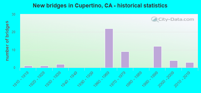
- New bridges - historical statistics
- 11910-1919
- 11920-1929
- 21930-1939
- 221960-1969
- 91970-1979
- 121990-1999
- 42000-2009
- 32010-2019

- Reconstructed bridges - Historical Statistics
- 11940-1949
- 11950-1959
- 01960-1969
- 01970-1979
- 01980-1989
- 11990-1999


- Bridge Condition - Deck
- 65.5%Good
- 13.8%Satisfactory
- 17.2%Fair
- 3.4%Poor

- Bridge Condition - Superstructure
- 66.7%Good
- 13.3%Satisfactory
- 20.0%Fair

- Bridge Condition - Substructure
- 86.7%Good
- 6.7%Satisfactory
- 6.7%Fair

- Bridge Condition - Channel
- 13.3%Excellent
- 40.0%Very good
- 13.3%Good
- 20.0%Satisfactory
- 13.3%Fair

- Bridge Condition - Culverts
- 33.3%Good
- 33.3%Satisfactory
- 33.3%Poor
Find on map >> Show street view
Structure Number: 37 0200F, Location: 04-SCL-237-R0.35-MVW (Lat: 37.384819, Lng: -122.069264), Route carried "on" structure: Ramp State highway 237, Year Built: 1965, Status: Open, Structure Length: 5.73m (18.80ft), Average Daily Traffic: 16,600 (year 2001), Truck Traffic: 3%, Average Future Daily Traffic: 26,614 (year 2041), Design Load: HS 20+Mod, Features Intersected: STEVENS CREEK & TRAIL
Minimum Vertical Clearance: 30+ m (98+ ft), Kilometerpoint: 0.350, Lanes on structure: 1, Base Highway Network: Yes (Inventory Route: 2, Subroute: 1), Owner: State Highway Agency, Approaching Roadway Width: 5.2m (17.1ft), Skew: 9 degrees, Material/Design: Concrete continuous, Design/Construction: Box Beam or Girders - Multiple, Number Of Spans In Main Unit: 4, Length of Maximum Span: 16.2m (53.1ft), Curb or Sidewalk Widths: Left: 0.0m, Right: 0.6m (2.0ft), Curb-To-Curb Width: 7.1m (23.3ft), Out-to-Out Width: 8.3m (27.2ft)
Condition: Deck: Poor, Superstructure: Good, Substructure: Good, Channel: Fair, Operating Rating: 61.9 metric tons, Method Used To Determine Operating Rating: Load Factor (LF), Inventory Rating: 37.3 metric tons, Method Used To Determine Inventory Rating: Load Factor (LF), Structural Evaluation: Better than present minimum criteria, Deck Geometry: Equal to present minimum criteria, Waterway Adequacy: Equal to present desirable criteria, Approach Roadway Alignment: Equal to present minimum criteria, Designated Inspection Frequency: Every 24 months, Inspection Date: April 2021, Deck Structure Type: Concrete Cast-file-Place
Find on map >> Show street view
Structure Number: 37 0206, Location: 04-SCL-280-9.43-CPO (Lat: 37.334058, Lng: -122.032106), Route carried "on" structure: City street , Year Built: 1965, Year Reconstructed: 1996, Status: Open, Structure Length: 7.01m (23.00ft), Average Daily Traffic: 138,500 (year 2012), Truck Traffic: 5%, Average Future Daily Traffic: 156,631 (year 2042), Design Load: HS 20, Features Intersected: INTERSTATE 280, Facility Carried by Structure: DE ANZA BOULEVARD
Minimum Vertical Clearance: 30+ m (98+ ft), Kilometerpoint: 0.000, Lanes on structure: 10, Lanes under structure: 8, Base Highway Network: Yes (Inventory Route: 2, Subroute: 1), Owner: State Highway Agency, Approaching Roadway Width: 41.6m (136.5ft), Skew: 20 degrees, Material/Design: Concrete continuous, Design/Construction: Box Beam or Girders - Multiple, Number Of Spans In Main Unit: 4, Length of Maximum Span: 24.4m (80.1ft), Curb or Sidewalk Widths: Left: 1.5m (4.9ft), Right: 1.5m (4.9ft), Curb-To-Curb Width: 41.5m (136.2ft), Out-to-Out Width: 46.6m (152.9ft)
Condition: Deck: Satisfactory, Superstructure: Good, Substructure: Good, Operating Rating: 54.1 metric tons, Method Used To Determine Operating Rating: Assigned rating based on Load Factor Design (LFD) reported in metric tons, Inventory Rating: 32.4 metric tons, Method Used To Determine Inventory Rating: Assigned rating based on Load Factor Design (LFD) reported in metric tons, Structural Evaluation: Better than present minimum criteria, Deck Geometry: Equal to present minimum criteria, Underclear: Somewhat better than minimum adequacy, Approach Roadway Alignment: Equal to present desirable criteria, Designated Inspection Frequency: Every 24 months, Inspection Date: January 2022, Deck Structure Type: Concrete Cast-file-Place
Find on map >> Show street view
Structure Number: 37 0208, Location: 04-SCL-085-R18.86-CPO (Lat: 37.337417, Lng: -122.060008), Route carried "on" structure: City street , Year Built: 1965, Status: Open, Structure Length: 7.50m (24.61ft), Average Daily Traffic: 14,256 (year 2012), Truck Traffic: 2%, Average Future Daily Traffic: 17,811 (year 2037), Design Load: HS 20, Features Intersected: STATE ROUTE 85, Facility Carried by Structure: HOMESTEAD ROAD
Minimum Vertical Clearance: 30+ m (98+ ft), Kilometerpoint: 0.000, Lanes on structure: 4, Lanes under structure: 10, Base Highway Network: Yes, Owner: State Highway Agency, Approaching Roadway Width: 20.0m (65.6ft), Skew: 1 degrees, Material/Design: Concrete continuous, Design/Construction: Box Beam or Girders - Multiple, Number Of Spans In Main Unit: 4, Length of Maximum Span: 25.6m (84.0ft), Curb or Sidewalk Widths: Left: 1.5m (4.9ft), Right: 1.5m (4.9ft), Curb-To-Curb Width: 19.7m (64.6ft), Out-to-Out Width: 23.8m (78.1ft)
Condition: Deck: Good, Superstructure: Satisfactory, Substructure: Good, Operating Rating: 43.1 metric tons, Method Used To Determine Operating Rating: Load and Resistance Factor Rating (LRFR) rating reported by rating factor(RF) method using HL-93 loadings, Inventory Rating: 32.4 metric tons, Method Used To Determine Inventory Rating: Load and Resistance Factor Rating (LRFR) rating reported by rating factor(RF) method using HL-93 loadings, Structural Evaluation: Equal to present minimum criteria, Deck Geometry: Better than present minimum criteria, Underclear: Meets minimum limits, Approach Roadway Alignment: Equal to present desirable criteria, Designated Inspection Frequency: Every 48 months, Inspection Date: June 2020, Deck Structure Type: Concrete Cast-file-Place
Find on map >> Show street view
Structure Number: 37 0209, Location: 04-SCL-280-9.94-CPO (Lat: 37.334006, Lng: -122.041386), Route carried "on" structure: City street C156, Year Built: 1965, Status: Open, Structure Length: 7.07m (23.20ft), Average Daily Traffic: 138,500 (year 2012), Truck Traffic: 1%, Average Future Daily Traffic: 153,535 (year 2040), Design Load: HS 20, Features Intersected: INTERSTATE 280, Facility Carried by Structure: STELLING ROAD
Minimum Vertical Clearance: 30+ m (98+ ft), Kilometerpoint: 0.000, Lanes on structure: 2, Lanes under structure: 10, Owner: State Highway Agency, Approaching Roadway Width: 12.5m (41.0ft), Material/Design: Concrete continuous, Design/Construction: Box Beam or Girders - Multiple, Number Of Spans In Main Unit: 4, Length of Maximum Span: 24.1m (79.1ft), Curb or Sidewalk Widths: Left: 1.6m (5.2ft), Right: 1.6m (5.2ft), Curb-To-Curb Width: 12.4m (40.7ft), Out-to-Out Width: 16.5m (54.1ft)
Condition: Deck: Good, Superstructure: Good, Substructure: Good, Operating Rating: 40.8 metric tons, Method Used To Determine Operating Rating: Load and Resistance Factor Rating (LRFR) rating reported by rating factor(RF) method using HL-93 loadings, Inventory Rating: 31.4 metric tons, Method Used To Determine Inventory Rating: Load and Resistance Factor Rating (LRFR) rating reported by rating factor(RF) method using HL-93 loadings, Structural Evaluation: Better than present minimum criteria, Deck Geometry: Somewhat better than minimum adequacy, Underclear: High priority of corrective action, Approach Roadway Alignment: Equal to present desirable criteria, Designated Inspection Frequency: Every 24 months, Inspection Date: January 2022, Deck Structure Type: Concrete Cast-file-Place, Wearing Surface/Protective System: Wearing Surface: Bituminous
Find on map >> Show street view
Structure Number: 37 0212, Location: 04-SCL-280-8.96-CPO (Lat: 37.333817, Lng: -122.023619), Route carried "on" structure: City street , Year Built: 1965, Status: Open, Structure Length: 9.33m (30.61ft), Average Daily Traffic: 8,460 (year 2000), Truck Traffic: 2%, Average Future Daily Traffic: 13,665 (year 2042), Design Load: HS 20, Features Intersected: INTERSTATE 280, Facility Carried by Structure: BLANEY AVENUE
Minimum Vertical Clearance: 30+ m (98+ ft), Kilometerpoint: 0.000, Lanes on structure: 2, Lanes under structure: 10, Owner: State Highway Agency, Approaching Roadway Width: 12.2m (40.0ft), Material/Design: Concrete continuous, Design/Construction: Box Beam or Girders - Multiple, Number Of Spans In Main Unit: 5, Length of Maximum Span: 24.8m (81.4ft), Curb or Sidewalk Widths: Left: 1.6m (5.2ft), Right: 1.6m (5.2ft), Curb-To-Curb Width: 12.2m (40.0ft), Out-to-Out Width: 16.6m (54.5ft)
Condition: Deck: Good, Superstructure: Good, Substructure: Good, Operating Rating: 34.0 metric tons, Method Used To Determine Operating Rating: Load and Resistance Factor Rating (LRFR) rating reported by rating factor(RF) method using HL-93 loadings, Inventory Rating: 26.2 metric tons, Method Used To Determine Inventory Rating: Load and Resistance Factor Rating (LRFR) rating reported by rating factor(RF) method using HL-93 loadings, Structural Evaluation: Equal to present minimum criteria, Deck Geometry: Somewhat better than minimum adequacy, Underclear: Somewhat better than minimum adequacy, Approach Roadway Alignment: Equal to present desirable criteria, Designated Inspection Frequency: Every 24 months, Inspection Date: January 2022, Deck Structure Type: Concrete Cast-file-Place, Wearing Surface/Protective System: Wearing Surface: Bituminous
Find on map >> Show street view
Structure Number: 37 0216, Location: 04-SCL-280-8.38-CPO (Lat: 37.330078, Lng: -122.014233), Route carried "on" structure: City street , Year Built: 1965, Status: Open, Structure Length: 10.26m (33.66ft), Average Daily Traffic: 138,500 (year 2012), Truck Traffic: 2%, Average Future Daily Traffic: 156,631 (year 2042), Design Load: HS 20+Mod, Features Intersected: INTERSTATE 280, Facility Carried by Structure: WOLFE ROAD
Minimum Vertical Clearance: 30+ m (98+ ft), Kilometerpoint: 0.000, Lanes on structure: 4, Lanes under structure: 11, Owner: State Highway Agency, Approaching Roadway Width: 17.2m (56.4ft), Skew: 23 degrees, Material/Design: Concrete continuous, Design/Construction: Box Beam or Girders - Multiple, Number Of Spans In Main Unit: 4, Length of Maximum Span: 28.8m (94.5ft), Curb or Sidewalk Widths: Left: 1.9m (6.2ft), Right: 1.9m (6.2ft), Curb-To-Curb Width: 17.1m (56.1ft), Out-to-Out Width: 23.8m (78.1ft)
Condition: Deck: Satisfactory, Superstructure: Good, Substructure: Good, Operating Rating: 42.8 metric tons, Method Used To Determine Operating Rating: Load and Resistance Factor Rating (LRFR) rating reported by rating factor(RF) method using HL-93 loadings, Inventory Rating: 30.5 metric tons, Method Used To Determine Inventory Rating: Load and Resistance Factor Rating (LRFR) rating reported by rating factor(RF) method using HL-93 loadings, Structural Evaluation: Better than present minimum criteria, Deck Geometry: Somewhat better than minimum adequacy, Underclear: Meets minimum limits, Approach Roadway Alignment: Equal to present desirable criteria, Designated Inspection Frequency: Every 24 months, Inspection Date: January 2022, Deck Structure Type: Concrete Cast-file-Place
Find on map >> Show street view
Structure Number: 37 0222, Location: 04-SCL-101-R35.46-SJS (Lat: 37.346175, Lng: -121.858928), Route carried "on" structure: City street , Year Built: 1993, Status: Open, Structure Length: 7.20m (23.62ft), Average Daily Traffic: 10,610 (year 1998), Truck Traffic: 1%, Average Future Daily Traffic: 16,086 (year 2043), Design Load: HS 20+Mod, Features Intersected: U.S. HIGHWAY 101, Facility Carried by Structure: SAN ANTONIO STREET
Minimum Vertical Clearance: 30+ m (98+ ft), Kilometerpoint: 0.000, Lanes on structure: 2, Lanes under structure: 10, Owner: State Highway Agency, Approaching Roadway Width: 10.5m (34.4ft), Skew: 1 degrees, Material/Design: Prestressed concrete continuous, Design/Construction: Box Beam or Girders - Multiple, Number Of Spans In Main Unit: 2, Length of Maximum Span: 35.6m (116.8ft), Curb or Sidewalk Widths: Left: 1.5m (4.9ft), Right: 1.5m (4.9ft), Curb-To-Curb Width: 10.3m (33.8ft), Out-to-Out Width: 13.8m (45.3ft)
Condition: Deck: Fair, Superstructure: Satisfactory, Substructure: Good, Operating Rating: 54.1 metric tons, Method Used To Determine Operating Rating: Assigned rating based on Load Factor Design (LFD) reported in metric tons, Inventory Rating: 32.4 metric tons, Method Used To Determine Inventory Rating: Assigned rating based on Load Factor Design (LFD) reported in metric tons, Structural Evaluation: Equal to present minimum criteria, Deck Geometry: Meets minimum limits, Underclear: Equal to present minimum criteria, Approach Roadway Alignment: Equal to present desirable criteria, Designated Inspection Frequency: Every 24 months, Inspection Date: Febuary 2021, Deck Structure Type: Concrete Cast-file-Place
Find on map >> Show street view
Structure Number: 37 0228F, Location: 04-SCL-085-R18.49-CPO (Lat: 37.331928, Lng: -122.056953), Route carried "on" structure: Ramp State highway 85, Year Built: 1967, Status: Open, Structure Length: 10.91m (35.79ft), Average Daily Traffic: 18,500 (year 2004), Truck Traffic: 2%, Average Future Daily Traffic: 28,947 (year 2037), Design Load: HS 20+Mod, Features Intersected: INTERSTATE 280
Minimum Vertical Clearance: 30+ m (98+ ft), Kilometerpoint: 18.490, Lanes on structure: 2, Lanes under structure: 8, Base Highway Network: Yes (, Subroute: 1), Owner: State Highway Agency, Approaching Roadway Width: 12.0m (39.4ft), Skew: 9 degrees, Material/Design: Concrete continuous, Design/Construction: Box Beam or Girders - Multiple, Number Of Spans In Main Unit: 4, Length of Maximum Span: 35.4m (116.1ft), Curb-To-Curb Width: 11.3m (37.1ft), Out-to-Out Width: 12.4m (40.7ft)
Condition: Deck: Satisfactory, Superstructure: Fair, Substructure: Fair, Operating Rating: 71.6 metric tons, Method Used To Determine Operating Rating: Load Factor (LF), Inventory Rating: 42.8 metric tons, Method Used To Determine Inventory Rating: Load Factor (LF), Structural Evaluation: Somewhat better than minimum adequacy, Deck Geometry: Superior to present desirable criteria, Underclear: Equal to present minimum criteria, Approach Roadway Alignment: Somewhat better than minimum adequacy, Designated Inspection Frequency: Every 24 months, Inspection Date: June 2020, Deck Structure Type: Concrete Cast-file-Place
Find on map >> Show street view
Structure Number: 37 0229G, Location: 04-SCL-085-R18.35-CPO (Lat: 37.331511, Lng: -122.053233), Route carried "on" structure: Ramp State highway 85, Year Built: 1971, Status: Open, Structure Length: 4.27m (14.01ft), Average Daily Traffic: 23,500 (year 2004), Truck Traffic: 2%, Average Future Daily Traffic: 36,702 (year 2037), Design Load: HS 20+Mod, Features Intersected: S85-S280 CONNECTOR
Minimum Vertical Clearance: 30+ m (98+ ft), Kilometerpoint: 18.350, Lanes on structure: 2, Lanes under structure: 3, Base Highway Network: Yes (, Subroute: 1), Owner: State Highway Agency, Approaching Roadway Width: 13.0m (42.7ft), Material/Design: Prestressed concrete, Design/Construction: Box Beam or Girders - Multiple, Number Of Spans In Main Unit: 1, Length of Maximum Span: 42.2m (138.5ft), Curb-To-Curb Width: 12.2m (40.0ft), Out-to-Out Width: 13.3m (43.6ft)
Condition: Deck: Good, Superstructure: Satisfactory, Substructure: Good, Operating Rating: 90.4 metric tons, Method Used To Determine Operating Rating: Load Factor (LF), Inventory Rating: 32.4 metric tons, Method Used To Determine Inventory Rating: Load Factor (LF), Structural Evaluation: Equal to present minimum criteria, Deck Geometry: Superior to present desirable criteria, Underclear: Meets minimum limits, Approach Roadway Alignment: Equal to present minimum criteria, Designated Inspection Frequency: Every 24 months, Inspection Date: June 2020, Deck Structure Type: Concrete Cast-file-Place
Find on map >> Show street view
Structure Number: 37 0231F, Location: 04-SCL-085-R18.60-CPO (Lat: 37.333061, Lng: -122.058256), Route carried "on" structure: Ramp State highway 85, Year Built: 1967, Status: Open, Structure Length: 2.97m (9.74ft), Average Daily Traffic: 18,500 (year 2004), Truck Traffic: 2%, Average Future Daily Traffic: 28,947 (year 2037), Design Load: H 20, Features Intersected: N85-N280 CONNECTOR
Minimum Vertical Clearance: 30+ m (98+ ft), Kilometerpoint: 18.600, Lanes on structure: 2, Lanes under structure: 2, Base Highway Network: Yes (, Subroute: 1), Owner: State Highway Agency, Approaching Roadway Width: 12.0m (39.4ft), Material/Design: Concrete, Design/Construction: Box Beam or Girders - Multiple, Number Of Spans In Main Unit: 1, Length of Maximum Span: 29.6m (97.1ft), Curb-To-Curb Width: 11.3m (37.1ft), Out-to-Out Width: 12.4m (40.7ft)
Condition: Deck: Good, Superstructure: Satisfactory, Substructure: Satisfactory, Operating Rating: 32.1 metric tons, Method Used To Determine Operating Rating: Load and Resistance Factor Rating (LRFR) rating reported by rating factor(RF) method using HL-93 loadings, Inventory Rating: 24.6 metric tons, Method Used To Determine Inventory Rating: Load and Resistance Factor Rating (LRFR) rating reported by rating factor(RF) method using HL-93 loadings, Structural Evaluation: Equal to present minimum criteria, Deck Geometry: Superior to present desirable criteria, Underclear: Better than present minimum criteria, Approach Roadway Alignment: Better than present minimum criteria, Designated Inspection Frequency: Every 24 months, Inspection Date: June 2020, Deck Structure Type: Concrete Cast-file-Place
Find on map >> Show street view
Structure Number: 37 0237, Location: 04-SCL-280-11.20-CPO (Lat: 37.333356, Lng: -122.062328), Route carried "on" structure: Interstate 280, Year Built: 1967, Status: Open, Structure Length: 0.88m (2.89ft), Average Daily Traffic: 138,000 (year 2009), Truck Traffic: 3%, Average Future Daily Traffic: 193,551 (year 2044), Design Load: HS 20, Features Intersected: STEVENS CREEK
Minimum Vertical Clearance: 30+ m (98+ ft), Kilometerpoint: 11.200, Lanes on structure: 10, Base Highway Network: Yes (Inventory Route: 2, Subroute: 1), Owner: State Highway Agency, Approaching Roadway Width: 53.3m (174.9ft), Skew: 32 degrees, Material/Design: Concrete, Design/Construction: Arch - Deck, Number Of Spans In Main Unit: 1, Length of Maximum Span: 6.7m (22.0ft)
Condition: Superstructure: Good, Substructure: Good, Channel: Very good, Operating Rating: 54.1 metric tons, Method Used To Determine Operating Rating: Field evaluation and documented engineering judgment, Inventory Rating: 32.4 metric tons, Method Used To Determine Inventory Rating: Field evaluation and documented engineering judgment, Structural Evaluation: Better than present minimum criteria, Waterway Adequacy: Equal to present desirable criteria, Approach Roadway Alignment: Equal to present desirable criteria, Designated Inspection Frequency: Every 48 months, Inspection Date: January 2022
Find on map >> Show street view
Structure Number: 37 0380L, Location: 04-SCL-237-10.20-MPS (Lat: 37.431869, Lng: -121.904078), Route carried "on" structure: State highway 237, Year Built: 1969, Status: Open, Structure Length: 11.85m (38.88ft), Average Daily Traffic: 36,500 (year 2009), Truck Traffic: 5%, Average Future Daily Traffic: 93,871 (year 2042), Design Load: HS 20+Mod, Features Intersected: UP RR YD,ACCESS RD,BARTD
Minimum Vertical Clearance: 30+ m (98+ ft), Kilometerpoint: 10.200, Lanes on structure: 2, Lanes under structure: 1, Base Highway Network: Yes (Inventory Route: 2, Subroute: 1), Owner: State Highway Agency, Approaching Roadway Width: 10.4m (34.1ft), Skew: 1 degrees, Material/Design: Concrete continuous, Design/Construction: Box Beam or Girders - Multiple, Number Of Spans In Main Unit: 5, Length of Maximum Span: 25.0m (82.0ft), Curb or Sidewalk Widths: Left: 1.5m (4.9ft), Right: 0.0m, Curb-To-Curb Width: 9.1m (29.9ft), Out-to-Out Width: 11.6m (38.1ft)
Condition: Deck: Good, Superstructure: Good, Substructure: Good, Operating Rating: 36.6 metric tons, Method Used To Determine Operating Rating: Load and Resistance Factor Rating (LRFR) rating reported by rating factor(RF) method using HL-93 loadings, Inventory Rating: 28.2 metric tons, Method Used To Determine Inventory Rating: Load and Resistance Factor Rating (LRFR) rating reported by rating factor(RF) method using HL-93 loadings, Structural Evaluation: Better than present minimum criteria, Deck Geometry: Meets minimum limits, Underclear: High priority of corrective action, Approach Roadway Alignment: Better than present minimum criteria, Designated Inspection Frequency: Every 24 months, Inspection Date: April 2020, Deck Structure Type: Concrete Cast-file-Place, Wearing Surface/Protective System: Wearing Surface: Integral Concrete
Find on map >> Show street view
Structure Number: 37 0384, Location: 04-SCL-085-R17.17-CPO (Lat: 37.315517, Lng: -122.047144), Route carried "on" structure: City street C169, Year Built: 1991, Status: Open, Structure Length: 6.77m (22.21ft), Average Daily Traffic: 14,990 (year 2000), Truck Traffic: 1%, Average Future Daily Traffic: 21,377 (year 2040), Design Load: HS 20+Mod, Features Intersected: STATE ROUTE 85, Facility Carried by Structure: MCCLELLAN ROAD
Minimum Vertical Clearance: 30+ m (98+ ft), Kilometerpoint: 0.000, Lanes on structure: 4, Lanes under structure: 7, Base Highway Network: Yes, Owner: State Highway Agency, Approaching Roadway Width: 15.5m (50.9ft), Skew: 2 degrees, Material/Design: Prestressed concrete continuous, Design/Construction: Box Beam or Girders - Multiple, Number Of Spans In Main Unit: 2, Length of Maximum Span: 35.6m (116.8ft), Curb or Sidewalk Widths: Left: 1.5m (4.9ft), Right: 1.8m (5.9ft), Curb-To-Curb Width: 15.5m (50.9ft), Out-to-Out Width: 19.4m (63.6ft)
Condition: Deck: Satisfactory, Superstructure: Fair, Substructure: Good, Operating Rating: 54.1 metric tons, Method Used To Determine Operating Rating: Assigned rating based on Load Factor Design (LFD) reported in metric tons, Inventory Rating: 32.4 metric tons, Method Used To Determine Inventory Rating: Assigned rating based on Load Factor Design (LFD) reported in metric tons, Structural Evaluation: Somewhat better than minimum adequacy, Deck Geometry: Meets minimum limits, Underclear: Somewhat better than minimum adequacy, Approach Roadway Alignment: Equal to present desirable criteria, Designated Inspection Frequency: Every 24 months, Inspection Date: August 2020, Deck Structure Type: Concrete Cast-file-Place
Find on map >> Show street view
Structure Number: 37 0388, Location: 04-SCL-085-R16.61-CPO (Lat: 37.308303, Lng: -122.041319), Route carried "on" structure: City street C156, Year Built: 1991, Status: Open, Structure Length: 9.60m (31.50ft), Average Daily Traffic: 22,200 (year 2000), Truck Traffic: 1%, Average Future Daily Traffic: 37,409 (year 2040), Design Load: HS 20+Mod, Features Intersected: STATE ROUTE 85, Facility Carried by Structure: STELLING ROAD
Minimum Vertical Clearance: 30+ m (98+ ft), Kilometerpoint: 0.000, Lanes on structure: 2, Lanes under structure: 6, Base Highway Network: Yes, Owner: State Highway Agency, Approaching Roadway Width: 17.1m (56.1ft), Skew: 4 degrees, Material/Design: Prestressed concrete continuous, Design/Construction: Box Beam or Girders - Multiple, Number Of Spans In Main Unit: 2, Length of Maximum Span: 48.3m (158.5ft), Curb or Sidewalk Widths: Left: 1.5m (4.9ft), Right: 1.5m (4.9ft), Curb-To-Curb Width: 17.1m (56.1ft), Out-to-Out Width: 20.7m (67.9ft)
Condition: Deck: Fair, Superstructure: Good, Substructure: Good, Operating Rating: 54.1 metric tons, Method Used To Determine Operating Rating: Assigned rating based on Load Factor Design (LFD) reported in metric tons, Inventory Rating: 32.4 metric tons, Method Used To Determine Inventory Rating: Assigned rating based on Load Factor Design (LFD) reported in metric tons, Structural Evaluation: Better than present minimum criteria, Deck Geometry: Superior to present desirable criteria, Underclear: Somewhat better than minimum adequacy, Approach Roadway Alignment: Equal to present desirable criteria, Designated Inspection Frequency: Every 24 months, Inspection Date: August 2020, Deck Structure Type: Concrete Cast-file-Place
Find on map >> Show street view
Structure Number: 37 039, Location: 04-SCL-101-42.73-SCL (Lat: 37.385333, Lng: -121.976806), Route carried "on" structure: City street , Year Built: 1975, Status: Open, Structure Length: 7.86m (25.79ft), Average Daily Traffic: 57,677 (year 1998), Truck Traffic: 1%, Average Future Daily Traffic: 74,348 (year 2043), Design Load: HS 20, Features Intersected: U.S. HIGHWAY 101, Facility Carried by Structure: BOWERS AVENUE
Minimum Vertical Clearance: 30+ m (98+ ft), Kilometerpoint: 0.000, Lanes on structure: 6, Lanes under structure: 10, Base Highway Network: Yes, Owner: State Highway Agency, Approaching Roadway Width: 32.0m (105.0ft), Skew: 20 degrees, Material/Design: Prestressed concrete continuous, Design/Construction: Box Beam or Girders - Multiple, Number Of Spans In Main Unit: 2, Length of Maximum Span: 39.3m (128.9ft), Curb or Sidewalk Widths: Left: 2.4m (7.9ft), Right: 2.4m (7.9ft), Curb-To-Curb Width: 31.7m (104.0ft), Out-to-Out Width: 39.0m (128.0ft)
Condition: Deck: Good, Superstructure: Good, Substructure: Good, Operating Rating: 49.6 metric tons, Method Used To Determine Operating Rating: Load and Resistance Factor Rating (LRFR) rating reported by rating factor(RF) method using HL-93 loadings, Inventory Rating: 36.3 metric tons, Method Used To Determine Inventory Rating: Load and Resistance Factor Rating (LRFR) rating reported by rating factor(RF) method using HL-93 loadings, Structural Evaluation: Better than present minimum criteria, Deck Geometry: Superior to present desirable criteria, Underclear: Equal to present minimum criteria, Approach Roadway Alignment: Equal to present desirable criteria, Designated Inspection Frequency: Every 24 months, Inspection Date: Febuary 2021, Deck Structure Type: Concrete Cast-file-Place
Find on map >> Show street view
Structure Number: 37 0397, Location: 04-SCL-280-7.84-CPO (Lat: 37.326025, Lng: -122.006272), Route carried "on" structure: City street C175, Year Built: 1976, Status: Open, Structure Length: 7.32m (24.02ft), Average Daily Traffic: 12,700 (year 2000), Truck Traffic: 2%, Average Future Daily Traffic: 19,550 (year 2040), Design Load: HS 20, Features Intersected: INTERSTATE 280, Facility Carried by Structure: TANTAU AVENUE
Minimum Vertical Clearance: 30+ m (98+ ft), Kilometerpoint: 0.000, Lanes on structure: 4, Lanes under structure: 10, Owner: State Highway Agency, Approaching Roadway Width: 18.3m (60.0ft), Skew: 1 degrees, Material/Design: Prestressed concrete continuous, Design/Construction: Box Beam or Girders - Multiple, Number Of Spans In Main Unit: 2, Length of Maximum Span: 36.9m (121.1ft), Curb or Sidewalk Widths: Left: 0.0m, Right: 1.7m (5.6ft), Curb-To-Curb Width: 16.8m (55.1ft), Out-to-Out Width: 20.8m (68.2ft)
Condition: Deck: Fair, Superstructure: Good, Substructure: Good, Operating Rating: 54.1 metric tons, Method Used To Determine Operating Rating: Assigned rating based on Load Factor Design (LFD) reported in metric tons, Inventory Rating: 32.4 metric tons, Method Used To Determine Inventory Rating: Assigned rating based on Load Factor Design (LFD) reported in metric tons, Structural Evaluation: Better than present minimum criteria, Deck Geometry: Somewhat better than minimum adequacy, Underclear: Somewhat better than minimum adequacy, Approach Roadway Alignment: Equal to present desirable criteria, Designated Inspection Frequency: Every 24 months, Inspection Date: January 2022, Deck Structure Type: Concrete Cast-file-Place
Find on map >> Show street view
Structure Number: 37 04, Location: 04-SCL-280-11.19-CPO (Lat: 37.333308, Lng: -122.062128), Route carried "on" structure: Interstate 280, Year Built: 1976, Status: Open, Structure Length: 0.73m (2.40ft), Average Daily Traffic: 138,000 (year 2009), Truck Traffic: 3%, Average Future Daily Traffic: 193,551 (year 2044), Design Load: HS 20, Features Intersected: STEVENS CREEK
Minimum Vertical Clearance: 30+ m (98+ ft), Kilometerpoint: 11.190, Lanes on structure: 10, Base Highway Network: Yes (Inventory Route: 2, Subroute: 1), Owner: State Highway Agency, Approaching Roadway Width: 53.3m (174.9ft), Skew: 32 degrees, Material/Design: Concrete, Design/Construction: Culvert, Number Of Spans In Main Unit: 1, Length of Maximum Span: 6.7m (22.0ft)
Condition: Channel: Very good, Culverts: Satisfactory, Operating Rating: 54.1 metric tons, Method Used To Determine Operating Rating: Field evaluation and documented engineering judgment, Inventory Rating: 32.4 metric tons, Method Used To Determine Inventory Rating: Field evaluation and documented engineering judgment, Structural Evaluation: Equal to present minimum criteria, Waterway Adequacy: Equal to present desirable criteria, Approach Roadway Alignment: Equal to present desirable criteria, Designated Inspection Frequency: Every 48 months, Inspection Date: January 2022
Find on map >> Show street view
Structure Number: 37 0405, Location: 04-SCL-280-7.93-CPO (Lat: 37.327222, Lng: -122.007300), Route carried "on" structure: Interstate 280, Year Built: 1965, Status: Open, Structure Length: 0.82m (2.69ft), Average Daily Traffic: 138,500 (year 2012), Truck Traffic: 3%, Average Future Daily Traffic: 162,471 (year 2044), Features Intersected: CALABAZAS CREEK
Minimum Vertical Clearance: 30+ m (98+ ft), Kilometerpoint: 7.930, Lanes on structure: 10, Base Highway Network: Yes (Inventory Route: 2, Subroute: 1), Owner: State Highway Agency, Approaching Roadway Width: 50.0m (164.0ft), Skew: 30 degrees, Material/Design: Concrete continuous, Design/Construction: Culvert, Number Of Spans In Main Unit: 2, Length of Maximum Span: 3.7m (12.1ft), Curb-To-Curb Width: 49.7m (163.1ft), Out-to-Out Width: 53.8m (176.5ft)
Condition: Channel: Good, Culverts: Good, Operating Rating: 54.1 metric tons, Method Used To Determine Operating Rating: Field evaluation and documented engineering judgment, Inventory Rating: 32.4 metric tons, Method Used To Determine Inventory Rating: Field evaluation and documented engineering judgment, Structural Evaluation: Better than present minimum criteria, Deck Geometry: Superior to present desirable criteria, Waterway Adequacy: Equal to present desirable criteria, Approach Roadway Alignment: Equal to present desirable criteria, Designated Inspection Frequency: Every 48 months, Inspection Date: January 2022
Find on map >> Show street view
Structure Number: 37 0466, Location: 04-SCL-085-R17.70-CPO (Lat: 37.322694, Lng: -122.050394), Route carried "on" structure: City street C028, Year Built: 1990, Status: Open, Structure Length: 7.41m (24.31ft), Average Daily Traffic: 30,249 (year 1998), Truck Traffic: 1%, Average Future Daily Traffic: 48,097 (year 2040), Design Load: HS 20+Mod, Features Intersected: STATE ROUTE 85, Facility Carried by Structure: STEVENS CREEK BLVD
Minimum Vertical Clearance: 30+ m (98+ ft), Kilometerpoint: 0.000, Lanes on structure: 9, Lanes under structure: 8, Base Highway Network: Yes, Owner: State Highway Agency, Approaching Roadway Width: 33.2m (108.9ft), Skew: 21 degrees, Material/Design: Prestressed concrete continuous, Design/Construction: Box Beam or Girders - Multiple, Number Of Spans In Main Unit: 2, Length of Maximum Span: 37.8m (124.0ft), Curb or Sidewalk Widths: Left: 1.5m (4.9ft), Right: 1.5m (4.9ft), Curb-To-Curb Width: 32.0m (105.0ft), Out-to-Out Width: 36.9m (121.1ft)
Condition: Deck: Good, Superstructure: Good, Substructure: Satisfactory, Operating Rating: 54.1 metric tons, Method Used To Determine Operating Rating: Assigned rating based on Load Factor Design (LFD) reported in metric tons, Inventory Rating: 32.4 metric tons, Method Used To Determine Inventory Rating: Assigned rating based on Load Factor Design (LFD) reported in metric tons, Structural Evaluation: Equal to present minimum criteria, Deck Geometry: High priority of replacement, Underclear: Equal to present minimum criteria, Approach Roadway Alignment: Equal to present desirable criteria, Designated Inspection Frequency: Every 24 months, Inspection Date: August 2020, Deck Structure Type: Concrete Cast-file-Place
Find on map >> Show street view
Structure Number: 37 0530L, Location: 04-SCL-085-6.00-SJS (Lat: 37.255661, Lng: -121.875339), Route carried "on" structure: State highway 85, Year Built: 1992, Status: Open, Structure Length: 7.26m (23.82ft), Average Daily Traffic: 52,500 (year 2009), Truck Traffic: 2%, Average Future Daily Traffic: 75,454 (year 2039), Design Load: HS 20+Mod, Features Intersected: ALMADEN EXPRESSWAY
Minimum Vertical Clearance: 30+ m (98+ ft), Kilometerpoint: 6.000, Lanes on structure: 4, Lanes under structure: 8, Base Highway Network: Yes (, Subroute: 1), Owner: State Highway Agency, Approaching Roadway Width: 21.0m (68.9ft), Skew: 1 degrees, Material/Design: Prestressed concrete continuous, Design/Construction: Box Beam or Girders - Multiple, Number Of Spans In Main Unit: 2, Length of Maximum Span: 36.6m (120.1ft), Curb-To-Curb Width: 21.0m (68.9ft), Out-to-Out Width: 22.0m (72.2ft)
Condition: Deck: Fair, Superstructure: Good, Substructure: Good, Operating Rating: 54.1 metric tons, Method Used To Determine Operating Rating: Assigned rating based on Load Factor Design (LFD) reported in metric tons, Inventory Rating: 32.4 metric tons, Method Used To Determine Inventory Rating: Assigned rating based on Load Factor Design (LFD) reported in metric tons, Structural Evaluation: Better than present minimum criteria, Deck Geometry: Better than present minimum criteria, Underclear: Equal to present minimum criteria, Approach Roadway Alignment: Equal to present desirable criteria, Designated Inspection Frequency: Every 24 months, Inspection Date: September 2021, Deck Structure Type: Concrete Cast-file-Place
Find on map >> Show street view
Structure Number: 37C0011, Location: 0.2 MI E/O STEVENS CYN RD (Lat: 37.322847, Lng: -122.061611), Route carried "on" structure: City street , Year Built: 1922, Year Reconstructed: 1947, Status: Open, Structure Length: 1.64m (5.38ft), Average Daily Traffic: 15,041 (year 2013), Truck Traffic: 2%, Average Future Daily Traffic: 15,599 (year 2040), Features Intersected: STEVENS CREEK, Facility Carried by Structure: STEVENS CR BLVD
Minimum Vertical Clearance: 30+ m (98+ ft), Kilometerpoint: 0.000, Lanes on structure: 2, Base Highway Network: Yes, Owner: City or Municipal Highway Agency, Approaching Roadway Width: 11.9m (39.0ft), Skew: 3 degrees, Material/Design: Concrete continuous, Design/Construction: Tee Beam, Number Of Spans In Main Unit: 2, Length of Maximum Span: 7.9m (25.9ft), Curb or Sidewalk Widths: Left: 0.4m (1.3ft), Right: 0.4m (1.3ft), Curb-To-Curb Width: 11.9m (39.0ft), Out-to-Out Width: 13.3m (43.6ft)
Condition: Deck: Good, Superstructure: Good, Substructure: Good, Channel: Satisfactory, Operating Rating: 34.0 metric tons, Method Used To Determine Operating Rating: Load and Resistance Factor Rating (LRFR) rating reported by rating factor(RF) method using HL-93 loadings, Inventory Rating: 23.7 metric tons, Method Used To Determine Inventory Rating: Load and Resistance Factor Rating (LRFR) rating reported by rating factor(RF) method using HL-93 loadings, Structural Evaluation: Somewhat better than minimum adequacy, Deck Geometry: Somewhat better than minimum adequacy, Waterway Adequacy: Meets minimum limits, Approach Roadway Alignment: Equal to present desirable criteria, Designated Inspection Frequency: Every 24 months, Inspection Date: May 2020, Deck Structure Type: Concrete Cast-file-Place, Wearing Surface/Protective System: Wearing Surface: Bituminous
Find on map >> Show street view
Structure Number: 37C0012, Location: AT VALLCO PKWY (Lat: 37.322806, Lng: -122.011128), Route carried "on" structure: City street , Year Built: 1978, Status: Open, Structure Length: 0.62m (2.03ft), Average Daily Traffic: 27,600 (year 2007), Truck Traffic: 2%, Average Future Daily Traffic: 27,810 (year 2042), Features Intersected: CALABAZAS CREEK, Facility Carried by Structure: STEVENS CR BLVD
Minimum Vertical Clearance: 30+ m (98+ ft), Kilometerpoint: 0.000, Lanes on structure: 11, Base Highway Network: Yes, Owner: City or Municipal Highway Agency, Approaching Roadway Width: 48.2m (158.1ft), Skew: 24 degrees, Material/Design: Concrete continuous, Design/Construction: Culvert, Number Of Spans In Main Unit: 2, Length of Maximum Span: 2.7m (8.9ft)
Condition: Channel: Very good, Culverts: Poor, Operating Rating: 54.1 metric tons, Method Used To Determine Operating Rating: Field evaluation and documented engineering judgment, Inventory Rating: 32.4 metric tons, Method Used To Determine Inventory Rating: Field evaluation and documented engineering judgment, Structural Evaluation: Meets minimum limits, Waterway Adequacy: Better than present minimum criteria, Approach Roadway Alignment: Equal to present desirable criteria, Length Of Structure Improvement: 0.62m (2.03ft), Designated Inspection Frequency: Every 24 months, Inspection Date: May 2020, Bridge Improvement Cost: $1,018,000
Find on map >> Show street view
Structure Number: 37C0017, Location: 14.5 MI E OF SH 84 (Lat: 37.337419, Lng: -122.062564), Route carried "on" structure: City street , Year Built: 1918, Year Reconstructed: 1955, Status: Open, Structure Length: 1.42m (4.66ft), Average Daily Traffic: 16,409 (year 2013), Truck Traffic: 4%, Average Future Daily Traffic: 14,375 (year 2040), Design Load: HS 20, Features Intersected: STEVENS CREEK, Facility Carried by Structure: HOMESTEAD RD
Minimum Vertical Clearance: 30+ m (98+ ft), Kilometerpoint: 0.000, Lanes on structure: 3, Base Highway Network: Yes, Owner: City or Municipal Highway Agency, Approaching Roadway Width: 18.0m (59.1ft), Skew: 2 degrees, Material/Design: Concrete, Design/Construction: Tee Beam, Number Of Spans In Main Unit: 1, Length of Maximum Span: 13.6m (44.6ft), Curb or Sidewalk Widths: Left: 1.2m (3.9ft), Right: 1.2m (3.9ft), Curb-To-Curb Width: 16.5m (54.1ft), Out-to-Out Width: 19.5m (64.0ft)
Condition: Deck: Good, Superstructure: Fair, Substructure: Fair, Channel: Satisfactory, Operating Rating: 35.6 metric tons, Method Used To Determine Operating Rating: Load Factor (LF), Inventory Rating: 21.4 metric tons, Method Used To Determine Inventory Rating: Load Factor (LF), Structural Evaluation: Somewhat better than minimum adequacy, Deck Geometry: Better than present minimum criteria, Waterway Adequacy: Equal to present minimum criteria, Approach Roadway Alignment: Equal to present desirable criteria, Designated Inspection Frequency: Every 24 months, Inspection Date: May 2020, Deck Structure Type: Concrete Cast-file-Place, Wearing Surface/Protective System: Wearing Surface: Bituminous
Find on map >> Show street view
Structure Number: 37C0043, Location: 0.9 MI S/O MONTEBELLO RD (Lat: 37.284406, Lng: -122.077164), Route carried "on" structure: County highway , Year Built: 1964, Status: Open, Structure Length: 2.37m (7.78ft), Average Daily Traffic: 1,330 (year 2014), Truck Traffic: 5%, Average Future Daily Traffic: 2,601 (year 2042), Design Load: HS 20, Features Intersected: STEVENS CR (STEVENS CYN), Facility Carried by Structure: STEVENS CANYON RD
Minimum Vertical Clearance: 30+ m (98+ ft), Kilometerpoint: 0.000, Lanes on structure: 2, Owner: County Highway Agency, Approaching Roadway Width: 8.2m (26.9ft), Skew: 2 degrees, Material/Design: Concrete continuous, Design/Construction: Slab, Number Of Spans In Main Unit: 3, Length of Maximum Span: 9.1m (29.9ft), Curb or Sidewalk Widths: Left: 1.3m (4.3ft), Right: 1.3m (4.3ft), Curb-To-Curb Width: 9.8m (32.2ft), Out-to-Out Width: 13.4m (44.0ft)
Condition: Deck: Good, Superstructure: Good, Substructure: Good, Channel: Fair, Operating Rating: 37.6 metric tons, Method Used To Determine Operating Rating: Load and Resistance Factor Rating (LRFR) rating reported by rating factor(RF) method using HL-93 loadings, Inventory Rating: 29.2 metric tons, Method Used To Determine Inventory Rating: Load and Resistance Factor Rating (LRFR) rating reported by rating factor(RF) method using HL-93 loadings, Structural Evaluation: Better than present minimum criteria, Deck Geometry: Somewhat better than minimum adequacy, Waterway Adequacy: Better than present minimum criteria, Approach Roadway Alignment: Better than present minimum criteria, Designated Inspection Frequency: Every 24 months, Inspection Date: Febuary 2022, Deck Structure Type: Concrete Cast-file-Place, Wearing Surface/Protective System: Wearing Surface: Bituminous
Find on map >> Show street view
Structure Number: 37C0302, Location: FORREST AVE (Lat: 37.327000, Lng: -121.940581), Route carried "on" structure: City street , Year Built: 1960, Status: Open, Structure Length: 2.19m (7.19ft), Average Daily Traffic: 1,500 (year 1977), Truck Traffic: 1%, Average Future Daily Traffic: 6,121 (year 2042), Features Intersected: FOREST AVE, Facility Carried by Structure: O'CONNOR DR
Minimum Vertical Clearance: 30+ m (98+ ft), Kilometerpoint: 0.000, Lanes on structure: 2, Lanes under structure: 4, Owner: City or Municipal Highway Agency, Approaching Roadway Width: 9.1m (29.9ft), Skew: 3 degrees, Material/Design: Concrete, Design/Construction: Box Beam or Girders - Multiple, Number Of Spans In Main Unit: 1, Length of Maximum Span: 21.3m (69.9ft), Curb or Sidewalk Widths: Left: 2.5m (8.2ft), Right: 0.6m (2.0ft), Curb-To-Curb Width: 9.2m (30.2ft), Out-to-Out Width: 12.7m (41.7ft)
Condition: Deck: Good, Superstructure: Fair, Substructure: Good, Operating Rating: 31.8 metric tons, Method Used To Determine Operating Rating: Load and Resistance Factor Rating (LRFR) rating reported by rating factor(RF) method using HL-93 loadings, Inventory Rating: 24.3 metric tons, Method Used To Determine Inventory Rating: Load and Resistance Factor Rating (LRFR) rating reported by rating factor(RF) method using HL-93 loadings, Structural Evaluation: Somewhat better than minimum adequacy, Deck Geometry: Somewhat better than minimum adequacy, Underclear: High priority of corrective action, Approach Roadway Alignment: Somewhat better than minimum adequacy, Designated Inspection Frequency: Every 24 months, Inspection Date: March 2020, Deck Structure Type: Concrete Cast-file-Place, Wearing Surface/Protective System: Wearing Surface: Bituminous
Find on map >> Show street view
Structure Number: 37C0347, Location: 0.1 MI S STATE RTE 237 (Lat: 37.328561, Lng: -122.014150), Route carried "on" structure: City street , Year Built: 1976, Status: Open, Structure Length: 1.91m (6.27ft), Average Daily Traffic: 50,069 (year 2013), Truck Traffic: 4%, Average Future Daily Traffic: 56,769 (year 2040), Design Load: HS 20, Features Intersected: PERIMETER ROAD, Facility Carried by Structure: WOLFE ROAD
Minimum Vertical Clearance: 30+ m (98+ ft), Kilometerpoint: 0.000, Lanes on structure: 7, Lanes under structure: 3, Owner: City or Municipal Highway Agency, Approaching Roadway Width: 30.5m (100.1ft), Skew: 30 degrees, Material/Design: Concrete continuous, Design/Construction: Frame, Number Of Spans In Main Unit: 2, Length of Maximum Span: 9.4m (30.8ft), Curb or Sidewalk Widths: Left: 1.4m (4.6ft), Right: 1.4m (4.6ft), Curb-To-Curb Width: 30.5m (100.1ft), Out-to-Out Width: 45.2m (148.3ft)
Condition: Deck: Good, Superstructure: Good, Substructure: Good, Operating Rating: 53.1 metric tons, Method Used To Determine Operating Rating: Load Factor (LF), Inventory Rating: 31.8 metric tons, Method Used To Determine Inventory Rating: Load Factor (LF), Structural Evaluation: Better than present minimum criteria, Deck Geometry: Better than present minimum criteria, Underclear: High priority of corrective action, Approach Roadway Alignment: Equal to present minimum criteria, Designated Inspection Frequency: Every 24 months, Inspection Date: May 2020
Find on map >> Show street view
Structure Number: 37C0364, Location: 0.2 MI S/O STEVENS CYN RD (Lat: 37.305853, Lng: -122.073278), Route carried "on" structure: County highway , Year Built: 1930, Status: Open, Structure Length: 0.89m (2.92ft), Average Daily Traffic: 250 (year 2014), Truck Traffic: 2%, Average Future Daily Traffic: 468 (year 2042), Features Intersected: STEVENS CREEK, Facility Carried by Structure: VILLA MARIA ENT RD
Minimum Vertical Clearance: 30+ m (98+ ft), Kilometerpoint: 0.000, Lanes on structure: 2, Owner: Local Agency, Approaching Roadway Width: 6.1m (20.0ft), Skew: 2 degrees, Material/Design: Concrete, Design/Construction: Tee Beam, Number Of Spans In Main Unit: 1, Length of Maximum Span: 8.2m (26.9ft), Curb-To-Curb Width: 6.1m (20.0ft), Out-to-Out Width: 6.7m (22.0ft)
Condition: Deck: Good, Superstructure: Fair, Substructure: Good, Channel: Good, Operating Rating: 26.2 metric tons, Method Used To Determine Operating Rating: Field evaluation and documented engineering judgment, Inventory Rating: 15.9 metric tons, Method Used To Determine Inventory Rating: Field evaluation and documented engineering judgment, Structural Evaluation: Meets minimum limits, Deck Geometry: Meets minimum limits, Waterway Adequacy: Equal to present minimum criteria, Approach Roadway Alignment: Somewhat better than minimum adequacy, Designated Inspection Frequency: Every 24 months, Inspection Date: Febuary 2022, Deck Structure Type: Concrete Cast-file-Place, Wearing Surface/Protective System: Wearing Surface: Bituminous
Find on map >> Show street view
Structure Number: 37C0365, Location: 0.3 MI S STEVENS CYN RD (Lat: 37.304083, Lng: -122.074511), Route carried "on" structure: County highway , Year Built: 1930, Status: Open, Structure Length: 1.86m (6.10ft), Average Daily Traffic: 250 (year 2014), Truck Traffic: 2%, Average Future Daily Traffic: 468 (year 2042), Features Intersected: STEVENS CREEK, Facility Carried by Structure: VILA MARIA ENTRY R
Minimum Vertical Clearance: 30+ m (98+ ft), Kilometerpoint: 0.000, Lanes on structure: 2, Owner: Local Agency, Approaching Roadway Width: 6.1m (20.0ft), Material/Design: Concrete continuous, Design/Construction: Tee Beam, Number Of Spans In Main Unit: 3, Length of Maximum Span: 12.5m (41.0ft), Curb or Sidewalk Widths: Left: 0.4m (1.3ft), Right: 0.4m (1.3ft), Curb-To-Curb Width: 6.1m (20.0ft), Out-to-Out Width: 6.9m (22.6ft)
Condition: Deck: Good, Superstructure: Good, Substructure: Good, Channel: Satisfactory, Operating Rating: 25.3 metric tons, Method Used To Determine Operating Rating: Field evaluation and documented engineering judgment, Inventory Rating: 15.2 metric tons, Method Used To Determine Inventory Rating: Field evaluation and documented engineering judgment, Structural Evaluation: Meets minimum limits, Deck Geometry: Meets minimum limits, Waterway Adequacy: Better than present minimum criteria, Approach Roadway Alignment: Equal to present minimum criteria, Designated Inspection Frequency: Every 24 months, Inspection Date: Febuary 2022, Deck Structure Type: Concrete Cast-file-Place, Wearing Surface/Protective System: Wearing Surface: Bituminous
Find on map >> Show street view
Structure Number: 37C0366, Location: .1 M SO. OF MT EDEN ROAD (Lat: 37.279742, Lng: -122.073586), Route carried "on" structure: County highway , Year Built: 1996, Status: Open, Structure Length: 0.97m (3.18ft), Average Daily Traffic: 100 (year 2014), Average Future Daily Traffic: 126 (year 2044), Features Intersected: Stevens Creek, Facility Carried by Structure: County Park Road
Minimum Vertical Clearance: 30+ m (98+ ft), Kilometerpoint: 0.000, Lanes on structure: 2, Owner: County Highway Agency, Approaching Roadway Width: 7.5m (24.6ft), Material/Design: Steel, Design/Construction: Stringer/Multi-beam, Number Of Spans In Main Unit: 1, Length of Maximum Span: 9.4m (30.8ft), Curb or Sidewalk Widths: Left: 0.0m, Right: 0.8m (2.6ft), Curb-To-Curb Width: 5.9m (19.4ft), Out-to-Out Width: 7.2m (23.6ft)
Condition: Deck: Good, Superstructure: Good, Substructure: Good, Channel: Excellent, Operating Rating: 63.2 metric tons, Method Used To Determine Operating Rating: Load and Resistance Factor Rating (LRFR) rating reported by rating factor(RF) method using HL-93 loadings, Inventory Rating: 48.6 metric tons, Method Used To Determine Inventory Rating: Load and Resistance Factor Rating (LRFR) rating reported by rating factor(RF) method using HL-93 loadings, Structural Evaluation: Better than present minimum criteria, Deck Geometry: Meets minimum limits, Waterway Adequacy: Equal to present desirable criteria, Approach Roadway Alignment: Equal to present minimum criteria, Designated Inspection Frequency: Every 48 months, Inspection Date: Febuary 2022, Deck Structure Type: Concrete Cast-file-Place
Find on map >> Show street view
Structure Number: 37C0431, Location: 0.2 M S. OF STEVENS CREEK (Lat: 37.319906, Lng: -122.013944), Route carried "on" structure: City street , Year Built: 2001, Status: Open, Structure Length: 1.16m (3.81ft), Average Daily Traffic: 1,000 (year 2012), Truck Traffic: 2%, Average Future Daily Traffic: 1,530 (year 2038), Features Intersected: CALABAZAS CREEK, Facility Carried by Structure: MILLER AVENUE
Minimum Vertical Clearance: 30+ m (98+ ft), Kilometerpoint: 0.000, Lanes on structure: 4, Owner: City or Municipal Highway Agency, Approaching Roadway Width: 26.7m (87.6ft), Skew: 23 degrees, Material/Design: Prestressed concrete, Design/Construction: Slab, Number Of Spans In Main Unit: 1, Length of Maximum Span: 10.4m (34.1ft), Curb or Sidewalk Widths: Left: 3.0m (9.8ft), Right: 2.5m (8.2ft), Curb-To-Curb Width: 22.3m (73.2ft), Out-to-Out Width: 29.0m (95.1ft)
Condition: Deck: Fair, Superstructure: Fair, Substructure: Good, Channel: Very good, Operating Rating: 54.1 metric tons, Method Used To Determine Operating Rating: Field evaluation and documented engineering judgment, Inventory Rating: 32.4 metric tons, Method Used To Determine Inventory Rating: Field evaluation and documented engineering judgment, Structural Evaluation: Somewhat better than minimum adequacy, Deck Geometry: Superior to present desirable criteria, Waterway Adequacy: Equal to present desirable criteria, Approach Roadway Alignment: Equal to present desirable criteria, Designated Inspection Frequency: Every 24 months, Inspection Date: May 2020, Deck Structure Type: Concrete Cast-file-Place
Find on map >> Show street view
Structure Number: 37C0604, Location: 2.5 MI SW/O MT EDEN ROAD (Lat: 37.274431, Lng: -122.106283), Route carried "on" structure: County highway , Year Built: 2016, Status: Open, Structure Length: 1.89m (6.20ft), Average Daily Traffic: 224 (year 2014), Average Future Daily Traffic: 304 (year 2038), Design Load: HL 93, Features Intersected: STEVENS CREEK, Facility Carried by Structure: STEVENS CAYON ROAD
Minimum Vertical Clearance: 30+ m (98+ ft), Kilometerpoint: 0.000, Lanes on structure: 2, Owner: County Highway Agency, Approaching Roadway Width: 9.3m (30.5ft), Skew: 3 degrees, Material/Design: Concrete, Design/Construction: Slab, Number Of Spans In Main Unit: 1, Length of Maximum Span: 18.3m (60.0ft), Curb-To-Curb Width: 9.3m (30.5ft), Out-to-Out Width: 10.2m (33.5ft)
Condition: Deck: Good, Superstructure: Good, Substructure: Good, Channel: Very good, Operating Rating: 54.1 metric tons, Method Used To Determine Operating Rating: Field evaluation and documented engineering judgment, Inventory Rating: 32.4 metric tons, Method Used To Determine Inventory Rating: Field evaluation and documented engineering judgment, Structural Evaluation: Better than present minimum criteria, Deck Geometry: Equal to present minimum criteria, Waterway Adequacy: Equal to present desirable criteria, Approach Roadway Alignment: Equal to present desirable criteria, Designated Inspection Frequency: Every 48 months, Inspection Date: Febuary 2020, Deck Structure Type: Concrete Cast-file-Place, Wearing Surface/Protective System: Wearing Surface: Monolithic Concrete
Find on map >> Show street view
Structure Number: 37C0605, Location: 2.7 MI SW/O MT EDEN ROAD (Lat: 37.276006, Lng: -122.109047), Route carried "on" structure: County highway , Year Built: 2016, Status: Open, Structure Length: 2.07m (6.79ft), Average Daily Traffic: 224 (year 2014), Average Future Daily Traffic: 304 (year 2038), Design Load: HL 93, Features Intersected: STEVENS CREEK, Facility Carried by Structure: STEVENS CAYON ROAD
Minimum Vertical Clearance: 99.90m (327.76ft), Kilometerpoint: 0.000, Lanes on structure: 2, Owner: County Highway Agency, Approaching Roadway Width: 9.3m (30.5ft), Skew: 3 degrees, Material/Design: Concrete, Design/Construction: Slab, Number Of Spans In Main Unit: 1, Length of Maximum Span: 20.0m (65.6ft), Curb-To-Curb Width: 9.3m (30.5ft), Out-to-Out Width: 10.2m (33.5ft)
Condition: Deck: Good, Superstructure: Good, Substructure: Good, Channel: Very good, Operating Rating: 54.0 metric tons, Method Used To Determine Operating Rating: Field evaluation and documented engineering judgment, Inventory Rating: 32.4 metric tons, Method Used To Determine Inventory Rating: Field evaluation and documented engineering judgment, Structural Evaluation: Better than present minimum criteria, Deck Geometry: Equal to present minimum criteria, Waterway Adequacy: Equal to present desirable criteria, Approach Roadway Alignment: Equal to present desirable criteria, Designated Inspection Frequency: Every 48 months, Inspection Date: Febuary 2020, Deck Structure Type: Concrete Cast-file-Place, Wearing Surface/Protective System: Wearing Surface: Monolithic Concrete
Find on map >> Show street view
Structure Number: 37C0606, Location: 2.9MI S/O MT EDEN RD (Lat: 37.276667, Lng: -122.110000), Route carried "on" structure: County highway , Year Built: 2011, Status: Open, Structure Length: 1.83m (6.00ft), Average Daily Traffic: 140 (year 2014), Truck Traffic: 5%, Average Future Daily Traffic: 225 (year 2040), Features Intersected: STEVENS CREEK, Facility Carried by Structure: STEVENS CYN RD
Minimum Vertical Clearance: 30+ m (98+ ft), Kilometerpoint: 0.000, Lanes on structure: 2, Owner: County Highway Agency, Approaching Roadway Width: 9.3m (30.5ft), Skew: 4 degrees, Material/Design: Concrete, Design/Construction: Box Beam or Girders - Single/Spread, Number Of Spans In Main Unit: 1, Length of Maximum Span: 15.8m (51.8ft), Curb-To-Curb Width: 9.3m (30.5ft), Out-to-Out Width: 10.2m (33.5ft)
Condition: Deck: Good, Superstructure: Good, Substructure: Good, Channel: Excellent, Operating Rating: 54.1 metric tons, Method Used To Determine Operating Rating: Field evaluation and documented engineering judgment, Inventory Rating: 32.4 metric tons, Method Used To Determine Inventory Rating: Field evaluation and documented engineering judgment, Structural Evaluation: Better than present minimum criteria, Deck Geometry: Equal to present minimum criteria, Waterway Adequacy: Equal to present minimum criteria, Approach Roadway Alignment: Equal to present minimum criteria, Designated Inspection Frequency: Every 48 months, Inspection Date: Febuary 2022, Deck Structure Type: Concrete Cast-file-Place
Find on map >> Show street view
Structure Number: 37 0206, Location: 04-SCL-280-9.43-CPO (Lat: 37.334058, Lng: -122.032106), Route carried "under" structure: Interstate 280, Year Built: 1965, Structure Length: 0. m, Average Daily Traffic: 138,000 (year 2009), Truck Traffic: 3%, Features Intersected: INTERSTATE 280, Facility Carried by Structure: DE ANZA BOULEVARD
Minimum Vertical Clearance: 5.03m (16.50ft), Kilometerpoint: 9.430, Lanes on structure: 10, Lanes under structure: 8, Material/Design: Concrete continuous, Design/Construction: Box Beam or Girders - Multiple, Length of Maximum Span: 24.4m (80.1ft)
Find on map >> Show street view
Structure Number: 37 0208, Location: 04-SCL-085-R18.86-CPO (Lat: 37.337417, Lng: -122.060008), Route carried "under" structure: State highway 85, Year Built: 1965, Structure Length: 0. m, Average Daily Traffic: 115,000 (year 2012), Truck Traffic: 3%, Features Intersected: STATE ROUTE 85, Facility Carried by Structure: HOMESTEAD ROAD
Minimum Vertical Clearance: 4.97m (16.31ft), Kilometerpoint: 18.860, Lanes on structure: 4, Lanes under structure: 10, Material/Design: Concrete continuous, Design/Construction: Box Beam or Girders - Multiple, Length of Maximum Span: 25.6m (84.0ft)
Find on map >> Show street view
Structure Number: 37 0209, Location: 04-SCL-280-9.94-CPO (Lat: 37.334006, Lng: -122.041386), Route carried "under" structure: Interstate 280, Year Built: 1965, Structure Length: 0. m, Average Daily Traffic: 138,000 (year 2009), Truck Traffic: 3%, Features Intersected: INTERSTATE 280, Facility Carried by Structure: STELLING ROAD
Minimum Vertical Clearance: 4.98m (16.34ft), Kilometerpoint: 9.940, Lanes on structure: 2, Lanes under structure: 10, Material/Design: Concrete continuous, Design/Construction: Box Beam or Girders - Multiple, Length of Maximum Span: 24.1m (79.1ft)
Find on map >> Show street view
Structure Number: 37 0212, Location: 04-SCL-280-8.96-CPO (Lat: 37.333817, Lng: -122.023619), Route carried "under" structure: Interstate 280, Year Built: 1965, Structure Length: 0. m, Average Daily Traffic: 138,000 (year 2009), Truck Traffic: 3%, Features Intersected: INTERSTATE 280, Facility Carried by Structure: BLANEY AVENUE
Minimum Vertical Clearance: 5.26m (17.26ft), Kilometerpoint: 8.960, Lanes on structure: 2, Lanes under structure: 8, Material/Design: Concrete continuous, Design/Construction: Box Beam or Girders - Multiple, Length of Maximum Span: 24.8m (81.4ft)
Find on map >> Show street view
Structure Number: 37 0216, Location: 04-SCL-280-8.38-CPO (Lat: 37.330078, Lng: -122.014233), Route carried "under" structure: Interstate 280, Year Built: 1965, Structure Length: 0. m, Average Daily Traffic: 138,000 (year 2009), Truck Traffic: 3%, Features Intersected: INTERSTATE 280, Facility Carried by Structure: WOLFE ROAD
Minimum Vertical Clearance: 4.97m (16.31ft), Kilometerpoint: 8.380, Lanes on structure: 4, Lanes under structure: 8, Material/Design: Concrete continuous, Design/Construction: Box Beam or Girders - Multiple, Length of Maximum Span: 28.8m (94.5ft)
Find on map >> Show street view
Structure Number: 37 0216, Location: 04-SCL-280-8.38-CPO (Lat: 37.330078, Lng: -122.014233), Route carried "under" structure: Ramp Interstate 280, Year Built: 1965, Structure Length: 0. m, Average Daily Traffic: 5,000 (year 1998), Truck Traffic: 3%, Features Intersected: INTERSTATE 280, Facility Carried by Structure: WOLFE ROAD
Minimum Vertical Clearance: 5.25m (17.22ft), Kilometerpoint: 8.380, Lanes on structure: 4, Lanes under structure: 2, Material/Design: Concrete continuous, Design/Construction: Box Beam or Girders - Multiple, Length of Maximum Span: 28.8m (94.5ft)
Find on map >> Show street view
Structure Number: 37 0216, Location: 04-SCL-280-8.38-CPO (Lat: 37.330078, Lng: -122.014233), Route carried "under" structure: Ramp Interstate 280, Year Built: 1965, Structure Length: 0. m, Average Daily Traffic: 5,000 (year 1998), Truck Traffic: 3%, Features Intersected: INTERSTATE 280, Facility Carried by Structure: WOLFE ROAD
Minimum Vertical Clearance: 4.93m (16.17ft), Kilometerpoint: 8.380, Lanes on structure: 4, Lanes under structure: 1, Material/Design: Concrete continuous, Design/Construction: Box Beam or Girders - Multiple, Length of Maximum Span: 28.8m (94.5ft)
Find on map >> Show street view
Structure Number: 37 0228F, Location: 04-SCL-085-R18.49-CPO (Lat: 37.331928, Lng: -122.056953), Route carried "under" structure: Interstate 280, Year Built: 1967, Structure Length: 0. m, Average Daily Traffic: 138,500 (year 1998), Truck Traffic: 2%, Features Intersected: INTERSTATE 280
Minimum Vertical Clearance: 5.35m (17.55ft), Kilometerpoint: 10.840, Lanes on structure: 2, Lanes under structure: 8, Material/Design: Concrete continuous, Design/Construction: Box Beam or Girders - Multiple, Length of Maximum Span: 35.4m (116.1ft)
Find on map >> Show street view
Structure Number: 37 0229G, Location: 04-SCL-085-R18.35-CPO (Lat: 37.331511, Lng: -122.053233), Route carried "under" structure: Ramp State highway 85, Year Built: 1971, Structure Length: 0. m, Average Daily Traffic: 18,500 (year 2004), Truck Traffic: 2%, Features Intersected: S85-S280 CONNECTOR
Minimum Vertical Clearance: 6.27m (20.57ft), Kilometerpoint: 18.350, Lanes on structure: 2, Lanes under structure: 3, Material/Design: Prestressed concrete, Design/Construction: Box Beam or Girders - Multiple, Length of Maximum Span: 42.2m (138.5ft)
Find on map >> Show street view
Structure Number: 37 0231F, Location: 04-SCL-085-R18.60-CPO (Lat: 37.333061, Lng: -122.058256), Route carried "under" structure: Ramp State highway 85, Year Built: 1967, Structure Length: 0. m, Average Daily Traffic: 22,600 (year 2001), Truck Traffic: 2%, Features Intersected: N85-N280 CONNECTOR
Minimum Vertical Clearance: 5.13m (16.83ft), Kilometerpoint: 18.600, Lanes on structure: 2, Lanes under structure: 2, Material/Design: Concrete, Design/Construction: Box Beam or Girders - Multiple, Length of Maximum Span: 29.6m (97.1ft)
Find on map >> Show street view
Structure Number: 37 0384, Location: 04-SCL-085-R17.17-CPO (Lat: 37.315517, Lng: -122.047144), Route carried "under" structure: State highway 85, Year Built: 1991, Structure Length: 0. m, Average Daily Traffic: 100,000 (year 2009), Truck Traffic: 4%, Features Intersected: STATE ROUTE 85, Facility Carried by Structure: MCCLELLAN ROAD
Minimum Vertical Clearance: 5.20m (17.06ft), Kilometerpoint: 17.170, Lanes on structure: 4, Lanes under structure: 7, Material/Design: Prestressed concrete continuous, Design/Construction: Box Beam or Girders - Multiple, Length of Maximum Span: 35.6m (116.8ft)
Find on map >> Show street view
Structure Number: 37 0388, Location: 04-SCL-085-R16.61-CPO (Lat: 37.308303, Lng: -122.041319), Route carried "under" structure: State highway 85, Year Built: 1991, Structure Length: 0. m, Average Daily Traffic: 100,000 (year 2009), Truck Traffic: 4%, Features Intersected: STATE ROUTE 85, Facility Carried by Structure: STELLING ROAD
Minimum Vertical Clearance: 5.23m (17.16ft), Kilometerpoint: 16.610, Lanes on structure: 2, Lanes under structure: 6, Material/Design: Prestressed concrete continuous, Design/Construction: Box Beam or Girders - Multiple, Length of Maximum Span: 48.3m (158.5ft)
Find on map >> Show street view
Structure Number: 37 0397, Location: 04-SCL-280-7.84-CPO (Lat: 37.326025, Lng: -122.006272), Route carried "under" structure: Interstate 280, Year Built: 1976, Structure Length: 0. m, Average Daily Traffic: 203,000 (year 2009), Truck Traffic: 3%, Features Intersected: INTERSTATE 280, Facility Carried by Structure: TANTAU AVENUE
Minimum Vertical Clearance: 5.46m (17.91ft), Kilometerpoint: 7.840, Lanes on structure: 4, Lanes under structure: 10, Material/Design: Prestressed concrete continuous, Design/Construction: Box Beam or Girders - Multiple, Length of Maximum Span: 36.9m (121.1ft)
Find on map >> Show street view
Structure Number: 37 0466, Location: 04-SCL-085-R17.70-CPO (Lat: 37.322694, Lng: -122.050394), Route carried "under" structure: State highway 85, Year Built: 1990, Structure Length: 0. m, Average Daily Traffic: 121,000 (year 2009), Truck Traffic: 1%, Features Intersected: STATE ROUTE 85, Facility Carried by Structure: STEVENS CREEK BLVD
Minimum Vertical Clearance: 5.20m (17.06ft), Kilometerpoint: 17.700, Lanes on structure: 9, Lanes under structure: 8, Material/Design: Prestressed concrete continuous, Design/Construction: Box Beam or Girders - Multiple, Length of Maximum Span: 37.8m (124.0ft)
Find on map >> Show street view
Structure Number: 37 0482, Location: 04-SCL-085-R14.84-CPO (Lat: 37.288297, Lng: -122.021578), Route carried "under" structure: State highway 85, Year Built: 1991, Structure Length: 0. m, Average Daily Traffic: 100,000 (year 2009), Truck Traffic: 4%, Features Intersected: STATE ROUTE 85, Facility Carried by Structure: PEDESTRIAN WALKWAY
Minimum Vertical Clearance: 5.76m (18.90ft), Kilometerpoint: 14.840, Lanes under structure: 6, Material/Design: Concrete continuous, Design/Construction: Box Beam or Girders - Multiple, Length of Maximum Span: 27.1m (88.9ft)
Find on map >> Show street view
Structure Number: 37 0531, Location: 04-SCL-085-R14.31-CPO (Lat: 37.282756, Lng: -122.015631), Route carried "under" structure: State highway 85, Year Built: 1992, Structure Length: 0. m, Average Daily Traffic: 100,000 (year 2009), Truck Traffic: 4%, Features Intersected: STATE ROUTE 85, Facility Carried by Structure: COX AVE UTILITY OC
Minimum Vertical Clearance: 5.48m (17.98ft), Kilometerpoint: 14.310, Lanes under structure: 6, Material/Design: Prestressed concrete continuous, Design/Construction: Box Beam or Girders - Multiple, Length of Maximum Span: 36.9m (121.1ft)