Bridge Statistics for Corona, California (CA)
Condition, Traffic, Stress, Structural Evaluation, Project Costs
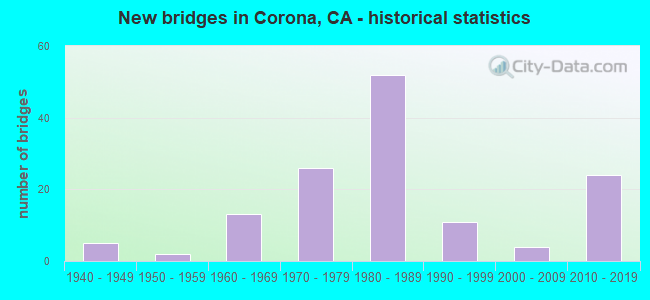
- New bridges - historical statistics
- 51940-1949
- 21950-1959
- 131960-1969
- 261970-1979
- 521980-1989
- 111990-1999
- 42000-2009
- 242010-2019

- Reconstructed bridges - Historical Statistics
- 51970-1979
- 71980-1989
- 01990-1999
- 32000-2009
- 102010-2019


- Bridge Condition - Deck
- 69.5%Good
- 29.3%Fair
- 1.2%Poor

- Bridge Condition - Superstructure
- 87.8%Good
- 12.2%Fair

- Bridge Condition - Substructure
- 85.4%Good
- 14.6%Fair

- Bridge Condition - Channel
- 46.0%Excellent
- 44.0%Very good
- 6.0%Good
- 2.0%Satisfactory
- 2.0%Serious

- Bridge Condition - Culverts
- 70.0%Good
- 10.0%Satisfactory
- 10.0%Fair
- 10.0%Poor
Find on map >> Show street view
Structure Number: 56 0351, Location: 08-RIV-010-R16.23-BAN (Lat: 33.931314, Lng: -116.827308), Route carried "on" structure: Interstate 10, Year Built: 1940, Year Reconstructed: 1970, Status: Open, Structure Length: 1.45m (4.76ft), Average Daily Traffic: 120,000 (year 2012), Truck Traffic: 18%, Average Future Daily Traffic: 176,000 (year 2040), Design Load: HS 20, Features Intersected: SAN GORGONIO OVERFLOW
Minimum Vertical Clearance: 30+ m (98+ ft), Kilometerpoint: 16.230, Lanes on structure: 8, Base Highway Network: Yes (, Subroute: 1), Owner: State Highway Agency, Approaching Roadway Width: 46.5m (152.6ft), Skew: 33 degrees, Material/Design: Concrete continuous, Design/Construction: Slab, Number Of Spans In Main Unit: 4, Length of Maximum Span: 7.2m (23.6ft), Curb-To-Curb Width: 45.1m (148.0ft), Out-to-Out Width: 46.5m (152.6ft)
Condition: Deck: Good, Superstructure: Good, Substructure: Fair, Channel: Good, Operating Rating: 99.8 metric tons, Method Used To Determine Operating Rating: Load Factor (LF), Inventory Rating: 81.6 metric tons, Method Used To Determine Inventory Rating: Load Factor (LF), Structural Evaluation: Somewhat better than minimum adequacy, Deck Geometry: Superior to present desirable criteria, Waterway Adequacy: Equal to present desirable criteria, Approach Roadway Alignment: Equal to present desirable criteria, Designated Inspection Frequency: Every 24 months, Inspection Date: November 2021, Deck Structure Type: Concrete Cast-file-Place
Find on map >> Show street view
Structure Number: 56 0357, Location: 08-RIV-091-4.71-COR (Lat: 33.882061, Lng: -117.594006), Route carried "on" structure: City street , Year Built: 1992, Status: Open, Structure Length: 7.80m (25.59ft), Average Daily Traffic: 6,000 (year 2012), Truck Traffic: 1%, Average Future Daily Traffic: 7,482 (year 2043), Design Load: HS 20, Features Intersected: ROUTE 91, Facility Carried by Structure: SMITH AVENUE
Minimum Vertical Clearance: 30+ m (98+ ft), Kilometerpoint: 0.000, Lanes on structure: 4, Lanes under structure: 14, Owner: State Highway Agency, Approaching Roadway Width: 19.5m (64.0ft), Skew: 1 degrees, Material/Design: Prestressed concrete continuous, Design/Construction: Box Beam or Girders - Multiple, Number Of Spans In Main Unit: 2, Length of Maximum Span: 39.0m (128.0ft), Curb or Sidewalk Widths: Left: 1.5m (4.9ft), Right: 1.5m (4.9ft), Curb-To-Curb Width: 19.5m (64.0ft), Out-to-Out Width: 23.2m (76.1ft)
Condition: Deck: Good, Superstructure: Good, Substructure: Good, Operating Rating: 54.1 metric tons, Method Used To Determine Operating Rating: Assigned rating based on Load Factor Design (LFD) reported in metric tons, Inventory Rating: 32.4 metric tons, Method Used To Determine Inventory Rating: Assigned rating based on Load Factor Design (LFD) reported in metric tons, Structural Evaluation: Better than present minimum criteria, Deck Geometry: Better than present minimum criteria, Underclear: Meets minimum limits, Approach Roadway Alignment: Superior to present desirable criteria, Designated Inspection Frequency: Every 24 months, Inspection Date: Febuary 2021, Deck Structure Type: Concrete Cast-file-Place
Find on map >> Show street view
Structure Number: 56 0363, Location: 08-RIV-091-5.70-COR (Lat: 33.881442, Lng: -117.577033), Route carried "on" structure: State highway 91, Year Built: 1961, Year Reconstructed: 2017, Status: Open, Structure Length: 2.07m (6.79ft), Average Daily Traffic: 268,000 (year 2015), Truck Traffic: 8%, Average Future Daily Traffic: 306,858 (year 2043), Design Load: HS 20, Features Intersected: BUENA VISTA AVENUE
Minimum Vertical Clearance: 30+ m (98+ ft), Kilometerpoint: 5.700, Lanes on structure: 18, Lanes under structure: 2, Base Highway Network: Yes (, Subroute: 1), Owner: State Highway Agency, Approaching Roadway Width: 82.6m (271.0ft), Skew: 30 degrees, Material/Design: Concrete, Design/Construction: Box Beam or Girders - Multiple, Number Of Spans In Main Unit: 1, Length of Maximum Span: 19.2m (63.0ft), Curb-To-Curb Width: 82.6m (271.0ft), Out-to-Out Width: 84.1m (275.9ft)
Condition: Deck: Fair, Superstructure: Good, Substructure: Good, Operating Rating: 94.3 metric tons, Method Used To Determine Operating Rating: Load Factor (LF), Inventory Rating: 56.7 metric tons, Method Used To Determine Inventory Rating: Load Factor (LF), Structural Evaluation: Better than present minimum criteria, Deck Geometry: Superior to present desirable criteria, Underclear: Equal to present minimum criteria, Approach Roadway Alignment: Superior to present desirable criteria, Designated Inspection Frequency: Every 24 months, Inspection Date: Febuary 2021, Deck Structure Type: Concrete Cast-file-Place
Find on map >> Show street view
Structure Number: 56 0364, Location: 08-RIV-091-6.65-COR (Lat: 33.879256, Lng: -117.560475), Route carried "on" structure: State highway 91, Year Built: 1961, Year Reconstructed: 2017, Status: Open, Structure Length: 3.95m (12.96ft), Average Daily Traffic: 250,000 (year 2019), Truck Traffic: 9%, Average Future Daily Traffic: 294,177 (year 2043), Design Load: HS 20, Features Intersected: EAST GRAND BLVD
Minimum Vertical Clearance: 30+ m (98+ ft), Kilometerpoint: 6.650, Lanes on structure: 16, Lanes under structure: 4, Base Highway Network: Yes (, Subroute: 1), Owner: State Highway Agency, Approaching Roadway Width: 99.1m (325.1ft), Skew: 34 degrees, Material/Design: Concrete, Design/Construction: Box Beam or Girders - Multiple, Number Of Spans In Main Unit: 1, Length of Maximum Span: 39.0m (128.0ft), Curb-To-Curb Width: 99.1m (325.1ft), Out-to-Out Width: 101.0m (331.4ft)
Condition: Deck: Good, Superstructure: Good, Substructure: Good, Operating Rating: 82.3 metric tons, Method Used To Determine Operating Rating: Load Factor (LF), Inventory Rating: 32.4 metric tons, Method Used To Determine Inventory Rating: Load Factor (LF), Structural Evaluation: Better than present minimum criteria, Deck Geometry: Superior to present desirable criteria, Underclear: Equal to present minimum criteria, Approach Roadway Alignment: Superior to present desirable criteria, Designated Inspection Frequency: Every 24 months, Inspection Date: Febuary 2021, Deck Structure Type: Concrete Cast-file-Place
Find on map >> Show street view
Structure Number: 56 0365, Location: 08-RIV-091-9.18-COR (Lat: 33.885994, Lng: -117.517750), Route carried "on" structure: State highway 91, Year Built: 1961, Year Reconstructed: 1994, Status: Open, Structure Length: 2.50m (8.20ft), Average Daily Traffic: 230,000 (year 2019), Truck Traffic: 10%, Average Future Daily Traffic: 276,329 (year 2040), Design Load: HS 20, Features Intersected: MCKINLEY STREET
Minimum Vertical Clearance: 30+ m (98+ ft), Kilometerpoint: 9.180, Lanes on structure: 11, Lanes under structure: 6, Base Highway Network: Yes (, Subroute: 1), Owner: State Highway Agency, Approaching Roadway Width: 35.5m (116.5ft), Skew: 30 degrees, Material/Design: Concrete, Design/Construction: Box Beam or Girders - Multiple, Number Of Spans In Main Unit: 1, Length of Maximum Span: 24.4m (80.1ft), Curb-To-Curb Width: 58.4m (191.6ft), Out-to-Out Width: 65.6m (215.2ft)
Condition: Deck: Fair, Superstructure: Good, Substructure: Good, Operating Rating: 91.0 metric tons, Method Used To Determine Operating Rating: Load Factor (LF), Inventory Rating: 54.8 metric tons, Method Used To Determine Inventory Rating: Load Factor (LF), Structural Evaluation: Better than present minimum criteria, Deck Geometry: Superior to present desirable criteria, Underclear: High priority of corrective action, Approach Roadway Alignment: Equal to present desirable criteria, Designated Inspection Frequency: Every 24 months, Inspection Date: April 2021, Deck Structure Type: Concrete Cast-file-Place
Find on map >> Show street view
Structure Number: 56 0366, Location: 08-RIV-091-R0.06 (Lat: 33.869764, Lng: -117.670542), Route carried "on" structure: US 91, Year Built: 1970, Year Reconstructed: 2010, Status: Open, Structure Length: 1.01m (3.31ft), Average Daily Traffic: 264,000 (year 2012), Truck Traffic: 7%, Average Future Daily Traffic: 298,718 (year 2037), Design Load: HS 20+Mod, Features Intersected: COAL CANYON
Minimum Vertical Clearance: 30+ m (98+ ft), Kilometerpoint: 0.060, Lanes on structure: 14, Lanes under structure: 1, Base Highway Network: Yes (, Subroute: 1), Owner: State Highway Agency, Approaching Roadway Width: 51.2m (168.0ft), Skew: 30 degrees, Material/Design: Concrete, Design/Construction: Frame, Number Of Spans In Main Unit: 1, Length of Maximum Span: 9.1m (29.9ft), Curb-To-Curb Width: 51.2m (168.0ft), Out-to-Out Width: 56.0m (183.7ft)
Condition: Deck: Good, Superstructure: Good, Substructure: Good, Operating Rating: 54.1 metric tons, Method Used To Determine Operating Rating: Assigned rating based on Load Factor Design (LFD) reported in metric tons, Inventory Rating: 32.4 metric tons, Method Used To Determine Inventory Rating: Assigned rating based on Load Factor Design (LFD) reported in metric tons, Structural Evaluation: Better than present minimum criteria, Deck Geometry: High priority of corrective action, Underclear: High priority of corrective action, Approach Roadway Alignment: Equal to present desirable criteria, Designated Inspection Frequency: Every 48 months, Inspection Date: Febuary 2019, Deck Structure Type: Concrete Cast-file-Place
Find on map >> Show street view
Structure Number: 56 0379, Location: 08-RIV-071-2.75 (Lat: 33.885564, Lng: -117.644692), Route carried "on" structure: State highway 71, Year Built: 1950, Year Reconstructed: 2000, Status: Open, Structure Length: 15.31m (50.23ft), Average Daily Traffic: 57,200 (year 2012), Truck Traffic: 11%, Average Future Daily Traffic: 172,153 (year 2042), Design Load: HS 20+Mod, Features Intersected: SANTA ANA RIVER
Minimum Vertical Clearance: 30+ m (98+ ft), Kilometerpoint: 2.750, Lanes on structure: 4, Base Highway Network: Yes (, Subroute: 1), Owner: State Highway Agency, Approaching Roadway Width: 21.6m (70.9ft), Skew: 32 degrees, Material/Design: Steel, Design/Construction: Stringer/Multi-beam, Number Of Spans In Main Unit: 5, Length of Maximum Span: 36.8m (120.7ft), Curb-To-Curb Width: 21.6m (70.9ft), Out-to-Out Width: 23.3m (76.4ft)
Condition: Deck: Good, Superstructure: Good, Substructure: Good, Channel: Very good, Operating Rating: 54.1 metric tons, Method Used To Determine Operating Rating: Assigned rating based on Load Factor Design (LFD) reported in metric tons, Inventory Rating: 32.4 metric tons, Method Used To Determine Inventory Rating: Assigned rating based on Load Factor Design (LFD) reported in metric tons, Structural Evaluation: Better than present minimum criteria, Deck Geometry: Better than present minimum criteria, Waterway Adequacy: Equal to present desirable criteria, Approach Roadway Alignment: Equal to present minimum criteria, Designated Inspection Frequency: Every 24 months, Other Special Inspection Frequency: Every 48 months, Inspection Date: January 2022, Other Special Inspection Date: April 2018, Deck Structure Type: Concrete Cast-file-Place
Find on map >> Show street view
Structure Number: 56 0444, Location: 08-RIV-015-27.50 (Lat: 33.733486, Lng: -117.406331), Route carried "on" structure: Interstate 15, Year Built: 1958, Year Reconstructed: 1980, Status: Open, Structure Length: 0.98m (3.22ft), Average Daily Traffic: 79,000 (year 2012), Truck Traffic: 13%, Average Future Daily Traffic: 211,259 (year 2042), Features Intersected: SIGN CREEK
Minimum Vertical Clearance: 30+ m (98+ ft), Kilometerpoint: 27.500, Lanes on structure: 6, Base Highway Network: Yes (, Subroute: 1), Owner: State Highway Agency, Approaching Roadway Width: 56.0m (183.7ft), Skew: 30 degrees, Material/Design: Concrete, Design/Construction: Culvert, Number Of Spans In Main Unit: 3, Length of Maximum Span: 3.0m (9.8ft), Curb-To-Curb Width: 56.0m (183.7ft), Out-to-Out Width: 56.0m (183.7ft)
Condition: Channel: Very good, Culverts: Good, Operating Rating: 54.1 metric tons, Method Used To Determine Operating Rating: Field evaluation and documented engineering judgment, Inventory Rating: 32.4 metric tons, Method Used To Determine Inventory Rating: Field evaluation and documented engineering judgment, Structural Evaluation: Better than present minimum criteria, Deck Geometry: Superior to present desirable criteria, Waterway Adequacy: Equal to present desirable criteria, Approach Roadway Alignment: Better than present minimum criteria, Designated Inspection Frequency: Every 24 months, Inspection Date: Febuary 2022
Find on map >> Show street view
Structure Number: 56 0445, Location: 08-RIV-091-5.99-COR (Lat: 33.880481, Lng: -117.571528), Route carried "on" structure: State highway 91, Year Built: 1961, Year Reconstructed: 2017, Status: Open, Structure Length: 9.84m (32.28ft), Average Daily Traffic: 261,000 (year 2012), Truck Traffic: 8%, Average Future Daily Traffic: 306,858 (year 2043), Design Load: HS 20, Features Intersected: WEST GRAND BLVD
Minimum Vertical Clearance: 30+ m (98+ ft), Kilometerpoint: 5.990, Lanes on structure: 18, Lanes under structure: 5, Base Highway Network: Yes (, Subroute: 1), Owner: State Highway Agency, Approaching Roadway Width: 89.9m (294.9ft), Skew: 39 degrees, Material/Design: Concrete continuous, Design/Construction: Box Beam or Girders - Multiple, Number Of Spans In Main Unit: 4, Length of Maximum Span: 39.3m (128.9ft), Curb-To-Curb Width: 89.9m (294.9ft), Out-to-Out Width: 91.6m (300.5ft)
Condition: Deck: Good, Superstructure: Good, Substructure: Good, Operating Rating: 67.1 metric tons, Method Used To Determine Operating Rating: Load Factor (LF), Inventory Rating: 40.2 metric tons, Method Used To Determine Inventory Rating: Load Factor (LF), Structural Evaluation: Better than present minimum criteria, Deck Geometry: Superior to present desirable criteria, Underclear: Equal to present minimum criteria, Approach Roadway Alignment: Equal to present desirable criteria, Designated Inspection Frequency: Every 24 months, Inspection Date: Febuary 2021, Deck Structure Type: Concrete Cast-file-Place
Find on map >> Show street view
Structure Number: 56 0446L, Location: 08-RIV-091-6.93-COR (Lat: 33.879444, Lng: -117.555939), Route carried "on" structure: State highway 91, Year Built: 1961, Year Reconstructed: 2017, Status: Open, Structure Length: 30.43m (99.84ft), Average Daily Traffic: 145,000 (year 2019), Truck Traffic: 9%, Average Future Daily Traffic: 171,000 (year 2041), Design Load: HS 20, Features Intersected: TEMESCAL WASH,BNSF,METRO
Minimum Vertical Clearance: 30+ m (98+ ft), Kilometerpoint: 6.930, Lanes on structure: 5, Base Highway Network: Yes (, Subroute: 1), Owner: State Highway Agency, Approaching Roadway Width: 24.3m (79.7ft), Skew: 9 degrees, Material/Design: Prestressed concrete continuous, Design/Construction: Box Beam or Girders - Multiple, Number Of Spans In Main Unit: 1, Number Of Approach Spans: 16, Length of Maximum Span: 45.9m (150.6ft), Curb-To-Curb Width: 24.3m (79.7ft), Out-to-Out Width: 25.3m (83.0ft)
Condition: Deck: Fair, Superstructure: Fair, Substructure: Good, Channel: Very good, Operating Rating: 54.1 metric tons, Method Used To Determine Operating Rating: Assigned rating based on Load Factor Design (LFD) reported in metric tons, Inventory Rating: 32.4 metric tons, Method Used To Determine Inventory Rating: Assigned rating based on Load Factor Design (LFD) reported in metric tons, Structural Evaluation: Somewhat better than minimum adequacy, Deck Geometry: Equal to present minimum criteria, Underclear: Superior to present desirable criteria, Waterway Adequacy: Equal to present desirable criteria, Approach Roadway Alignment: Equal to present desirable criteria, Designated Inspection Frequency: Every 24 months, Inspection Date: April 2021, Deck Structure Type: Concrete Cast-file-Place
Find on map >> Show street view
Structure Number: 56 049, Location: 08-RIV-371-65.44 (Lat: 33.530261, Lng: -116.768733), Route carried "on" structure: State highway 371, Year Built: 1943, Year Reconstructed: 1977, Status: Open, Structure Length: 1.35m (4.43ft), Average Daily Traffic: 7,600 (year 2011), Truck Traffic: 6%, Average Future Daily Traffic: 9,929 (year 2043), Design Load: HS 20+Mod, Features Intersected: CAHUILLA CREEK
Minimum Vertical Clearance: 30+ m (98+ ft), Kilometerpoint: 65.440, Lanes on structure: 2, Base Highway Network: Yes (Inventory Route: 3, Subroute: 1), Owner: State Highway Agency, Approaching Roadway Width: 9.9m (32.5ft), Skew: 3 degrees, Material/Design: Prestressed concrete, Design/Construction: Slab, Number Of Spans In Main Unit: 1, Length of Maximum Span: 13.5m (44.3ft), Curb-To-Curb Width: 9.9m (32.5ft), Out-to-Out Width: 10.1m (33.1ft)
Condition: Deck: Good, Superstructure: Good, Substructure: Fair, Channel: Very good, Operating Rating: 49.9 metric tons, Method Used To Determine Operating Rating: Load Factor (LF), Inventory Rating: 32.4 metric tons, Method Used To Determine Inventory Rating: Load Factor (LF), Structural Evaluation: Somewhat better than minimum adequacy, Deck Geometry: Meets minimum limits, Waterway Adequacy: Equal to present desirable criteria, Approach Roadway Alignment: Equal to present desirable criteria, Designated Inspection Frequency: Every 24 months, Inspection Date: March 2021, Deck Structure Type: Concrete Cast-file-Place, Wearing Surface/Protective System: Wearing Surface: Bituminous
Find on map >> Show street view
Structure Number: 56 0494, Location: 08-RIV-015-40.96-COR (Lat: 33.874142, Lng: -117.545269), Route carried "on" structure: Interstate 15, Year Built: 1986, Year Reconstructed: 2017, Status: Open, Structure Length: 4.54m (14.90ft), Average Daily Traffic: 170,000 (year 2017), Truck Traffic: 3%, Average Future Daily Traffic: 230,000 (year 2037), Design Load: HS 20+Mod, Features Intersected: SIXTH STREET
Minimum Vertical Clearance: 30+ m (98+ ft), Kilometerpoint: 40.960, Lanes on structure: 10, Lanes under structure: 5, Base Highway Network: Yes (, Subroute: 1), Owner: State Highway Agency, Approaching Roadway Width: 59.2m (194.2ft), Skew: 1 degrees, Material/Design: Prestressed concrete, Design/Construction: Box Beam or Girders - Multiple, Number Of Spans In Main Unit: 1, Length of Maximum Span: 44.6m (146.3ft), Curb-To-Curb Width: 59.2m (194.2ft), Out-to-Out Width: 61.3m (201.1ft)
Condition: Deck: Fair, Superstructure: Good, Substructure: Good, Operating Rating: 54.1 metric tons, Method Used To Determine Operating Rating: Assigned rating based on Load Factor Design (LFD) reported in metric tons, Inventory Rating: 32.4 metric tons, Method Used To Determine Inventory Rating: Assigned rating based on Load Factor Design (LFD) reported in metric tons, Structural Evaluation: Better than present minimum criteria, Deck Geometry: Superior to present desirable criteria, Underclear: Equal to present minimum criteria, Approach Roadway Alignment: Equal to present desirable criteria, Designated Inspection Frequency: Every 24 months, Inspection Date: Febuary 2020, Deck Structure Type: Concrete Cast-file-Place
Find on map >> Show street view
Structure Number: 56 0495G, Location: 08-RIV-015-41.25-COR (Lat: 33.878050, Lng: -117.545414), Route carried "on" structure: Ramp Interstate 15, Year Built: 1981, Year Reconstructed: 1988, Status: Open, Structure Length: 10.87m (35.66ft), Average Daily Traffic: 30,000 (year 2012), Truck Traffic: 2%, Average Future Daily Traffic: 33,443 (year 2036), Design Load: HS 20+Mod, Features Intersected: BNSF RY,AMTRAK,METROLINK
Minimum Vertical Clearance: 30+ m (98+ ft), Kilometerpoint: 41.250, Lanes on structure: 3, Base Highway Network: Yes, Owner: State Highway Agency, Approaching Roadway Width: 15.9m (52.2ft), Skew: 1 degrees, Material/Design: Prestressed concrete continuous, Design/Construction: Stringer/Multi-beam, Number Of Spans In Main Unit: 5, Length of Maximum Span: 28.2m (92.5ft), Curb-To-Curb Width: 15.9m (52.2ft), Out-to-Out Width: 19.1m (62.7ft)
Condition: Deck: Good, Superstructure: Good, Substructure: Good, Channel: Very good, Operating Rating: 54.1 metric tons, Method Used To Determine Operating Rating: Assigned rating based on Load Factor Design (LFD) reported in metric tons, Inventory Rating: 32.4 metric tons, Method Used To Determine Inventory Rating: Assigned rating based on Load Factor Design (LFD) reported in metric tons, Structural Evaluation: Better than present minimum criteria, Deck Geometry: Superior to present desirable criteria, Underclear: Superior to present desirable criteria, Waterway Adequacy: Equal to present desirable criteria, Approach Roadway Alignment: Superior to present desirable criteria, Designated Inspection Frequency: Every 48 months, Inspection Date: March 2018, Deck Structure Type: Concrete Cast-file-Place
Find on map >> Show street view
Structure Number: 56 0495L, Location: 08-RIV-015-41.25-COR (Lat: 33.878172, Lng: -117.546239), Route carried "on" structure: Interstate 15, Year Built: 1988, Status: Open, Structure Length: 11.64m (38.19ft), Average Daily Traffic: 76,500 (year 2012), Truck Traffic: 6%, Average Future Daily Traffic: 185,670 (year 2042), Design Load: HS 20+Mod, Features Intersected: BNSF RY,AMTRAK,METROLINK
Minimum Vertical Clearance: 30+ m (98+ ft), Kilometerpoint: 41.250, Lanes on structure: 5, Base Highway Network: Yes (, Subroute: 1), Owner: State Highway Agency, Approaching Roadway Width: 24.7m (81.0ft), Skew: 2 degrees, Material/Design: Concrete continuous, Design/Construction: Box Beam or Girders - Multiple, Number Of Spans In Main Unit: 5, Length of Maximum Span: 29.6m (97.1ft), Curb-To-Curb Width: 24.7m (81.0ft), Out-to-Out Width: 26.0m (85.3ft)
Condition: Deck: Poor, Superstructure: Good, Substructure: Good, Channel: Very good, Operating Rating: 54.1 metric tons, Method Used To Determine Operating Rating: Assigned rating based on Load Factor Design (LFD) reported in metric tons, Inventory Rating: 32.4 metric tons, Method Used To Determine Inventory Rating: Assigned rating based on Load Factor Design (LFD) reported in metric tons, Structural Evaluation: Better than present minimum criteria, Deck Geometry: Better than present minimum criteria, Underclear: Superior to present desirable criteria, Waterway Adequacy: Equal to present desirable criteria, Approach Roadway Alignment: Equal to present minimum criteria, Designated Inspection Frequency: Every 24 months, Inspection Date: Febuary 2020, Deck Structure Type: Concrete Cast-file-Place
Find on map >> Show street view
Structure Number: 56 0495R, Location: 08-RIV-015-41.25-COR (Lat: 33.878117, Lng: -117.545864), Route carried "on" structure: Interstate 15, Year Built: 1988, Status: Open, Structure Length: 11.64m (38.19ft), Average Daily Traffic: 76,500 (year 2012), Truck Traffic: 6%, Average Future Daily Traffic: 185,670 (year 2042), Design Load: HS 20+Mod, Features Intersected: BNSF RY,AMTRAK,METROLINK
Minimum Vertical Clearance: 30+ m (98+ ft), Kilometerpoint: 41.250, Lanes on structure: 3, Base Highway Network: Yes (, Subroute: 1), Owner: State Highway Agency, Approaching Roadway Width: 16.2m (53.1ft), Skew: 2 degrees, Material/Design: Concrete continuous, Design/Construction: Box Beam or Girders - Multiple, Number Of Spans In Main Unit: 5, Length of Maximum Span: 29.6m (97.1ft), Curb-To-Curb Width: 16.2m (53.1ft), Out-to-Out Width: 17.3m (56.8ft)
Condition: Deck: Fair, Superstructure: Good, Substructure: Good, Channel: Very good, Operating Rating: 54.1 metric tons, Method Used To Determine Operating Rating: Assigned rating based on Load Factor Design (LFD) reported in metric tons, Inventory Rating: 32.4 metric tons, Method Used To Determine Inventory Rating: Assigned rating based on Load Factor Design (LFD) reported in metric tons, Structural Evaluation: Better than present minimum criteria, Deck Geometry: Equal to present minimum criteria, Underclear: Superior to present desirable criteria, Waterway Adequacy: Equal to present desirable criteria, Approach Roadway Alignment: Better than present minimum criteria, Designated Inspection Frequency: Every 24 months, Inspection Date: Febuary 2020, Deck Structure Type: Concrete Cast-file-Place
Find on map >> Show street view
Structure Number: 56 0497, Location: 08-RIV-015-40.35-COR (Lat: 33.865486, Lng: -117.542558), Route carried "on" structure: City street R100, Year Built: 1975, Year Reconstructed: 2005, Status: Open, Structure Length: 8.50m (27.89ft), Average Daily Traffic: 165,000 (year 2012), Truck Traffic: 1%, Average Future Daily Traffic: 188,731 (year 2042), Design Load: HS 20, Features Intersected: INTERSTATE 15, Facility Carried by Structure: MAGNOLIA AVENUE
Minimum Vertical Clearance: 30+ m (98+ ft), Kilometerpoint: 0.000, Lanes on structure: 9, Lanes under structure: 8, Owner: State Highway Agency, Approaching Roadway Width: 35.4m (116.1ft), Skew: 20 degrees, Material/Design: Prestressed concrete continuous, Design/Construction: Box Beam or Girders - Multiple, Number Of Spans In Main Unit: 2, Length of Maximum Span: 47.7m (156.5ft), Curb or Sidewalk Widths: Left: 1.5m (4.9ft), Right: 1.5m (4.9ft), Curb-To-Curb Width: 35.4m (116.1ft), Out-to-Out Width: 39.0m (128.0ft)
Condition: Deck: Fair, Superstructure: Good, Substructure: Fair, Operating Rating: 57.0 metric tons, Method Used To Determine Operating Rating: Load and Resistance Factor Rating (LRFR) rating reported by rating factor(RF) method using HL-93 loadings, Inventory Rating: 37.6 metric tons, Method Used To Determine Inventory Rating: Load and Resistance Factor Rating (LRFR) rating reported by rating factor(RF) method using HL-93 loadings, Structural Evaluation: Somewhat better than minimum adequacy, Deck Geometry: Somewhat better than minimum adequacy, Underclear: Better than present minimum criteria, Approach Roadway Alignment: Superior to present desirable criteria, Designated Inspection Frequency: Every 24 months, Inspection Date: Febuary 2020, Deck Structure Type: Concrete Cast-file-Place
Find on map >> Show street view
Structure Number: 56 0498L, Location: 08-RIV-015-38.69-COR (Lat: 33.843714, Lng: -117.535014), Route carried "on" structure: Interstate 15, Year Built: 1975, Status: Open, Structure Length: 5.18m (16.99ft), Average Daily Traffic: 110,000 (year 2012), Truck Traffic: 10%, Average Future Daily Traffic: 127,521 (year 2042), Design Load: HS 20, Features Intersected: ONTARIO AVENUE
Minimum Vertical Clearance: 30+ m (98+ ft), Kilometerpoint: 38.690, Lanes on structure: 4, Lanes under structure: 4, Base Highway Network: Yes (, Subroute: 1), Owner: State Highway Agency, Approaching Roadway Width: 19.7m (64.6ft), Skew: 4 degrees, Material/Design: Prestressed concrete, Design/Construction: Box Beam or Girders - Multiple, Number Of Spans In Main Unit: 1, Length of Maximum Span: 51.8m (169.9ft), Curb-To-Curb Width: 19.7m (64.6ft), Out-to-Out Width: 20.7m (67.9ft)
Condition: Deck: Good, Superstructure: Good, Substructure: Good, Operating Rating: 54.1 metric tons, Method Used To Determine Operating Rating: Assigned rating based on Load Factor Design (LFD) reported in metric tons, Inventory Rating: 32.4 metric tons, Method Used To Determine Inventory Rating: Assigned rating based on Load Factor Design (LFD) reported in metric tons, Structural Evaluation: Better than present minimum criteria, Deck Geometry: Equal to present minimum criteria, Underclear: Meets minimum limits, Approach Roadway Alignment: Equal to present desirable criteria, Designated Inspection Frequency: Every 24 months, Inspection Date: Febuary 2020, Deck Structure Type: Concrete Cast-file-Place
Find on map >> Show street view
Structure Number: 56 0498R, Location: 08-RIV-015-38.69-COR (Lat: 33.843383, Lng: -117.534608), Route carried "on" structure: Interstate 15, Year Built: 1975, Status: Open, Structure Length: 5.25m (17.22ft), Average Daily Traffic: 110,000 (year 2012), Truck Traffic: 17%, Average Future Daily Traffic: 127,521 (year 2042), Design Load: HS 20, Features Intersected: ONTARIO AVENUE
Minimum Vertical Clearance: 30+ m (98+ ft), Kilometerpoint: 38.690, Lanes on structure: 4, Lanes under structure: 5, Base Highway Network: Yes (, Subroute: 1), Owner: State Highway Agency, Approaching Roadway Width: 19.7m (64.6ft), Skew: 4 degrees, Material/Design: Prestressed concrete, Design/Construction: Box Beam or Girders - Multiple, Number Of Spans In Main Unit: 1, Length of Maximum Span: 52.4m (171.9ft), Curb-To-Curb Width: 19.7m (64.6ft), Out-to-Out Width: 20.7m (67.9ft)
Condition: Deck: Good, Superstructure: Good, Substructure: Good, Operating Rating: 54.1 metric tons, Method Used To Determine Operating Rating: Assigned rating based on Load Factor Design (LFD) reported in metric tons, Inventory Rating: 32.4 metric tons, Method Used To Determine Inventory Rating: Assigned rating based on Load Factor Design (LFD) reported in metric tons, Structural Evaluation: Better than present minimum criteria, Deck Geometry: Equal to present minimum criteria, Underclear: Meets minimum limits, Approach Roadway Alignment: Equal to present desirable criteria, Designated Inspection Frequency: Every 24 months, Inspection Date: Febuary 2020, Deck Structure Type: Concrete Cast-file-Place
Find on map >> Show street view
Structure Number: 56 0499, Location: 08-RIV-015-40.86-COR (Lat: 33.872719, Lng: -117.544653), Route carried "on" structure: Interstate 15, Year Built: 1984, Year Reconstructed: 2017, Status: Open, Structure Length: 5.18m (16.99ft), Average Daily Traffic: 156,000 (year 2009), Average Future Daily Traffic: 228,235 (year 2039), Design Load: HS 20+Mod, Features Intersected: TEMESCAL WASH
Minimum Vertical Clearance: 30+ m (98+ ft), Kilometerpoint: 40.860, Lanes on structure: 11, Base Highway Network: Yes (, Subroute: 1), Owner: State Highway Agency, Approaching Roadway Width: 59.3m (194.6ft), Skew: 32 degrees, Material/Design: Concrete continuous, Design/Construction: Box Beam or Girders - Multiple, Number Of Spans In Main Unit: 2, Length of Maximum Span: 25.3m (83.0ft), Curb-To-Curb Width: 59.3m (194.6ft), Out-to-Out Width: 61.0m (200.1ft)
Condition: Deck: Fair, Superstructure: Good, Substructure: Good, Channel: Very good, Operating Rating: 54.1 metric tons, Method Used To Determine Operating Rating: Assigned rating based on Load Factor Design (LFD) reported in metric tons, Inventory Rating: 32.4 metric tons, Method Used To Determine Inventory Rating: Assigned rating based on Load Factor Design (LFD) reported in metric tons, Structural Evaluation: Better than present minimum criteria, Deck Geometry: Superior to present desirable criteria, Waterway Adequacy: Superior to present desirable criteria, Approach Roadway Alignment: Superior to present desirable criteria, Designated Inspection Frequency: Every 24 months, Inspection Date: Febuary 2020, Deck Structure Type: Concrete Cast-file-Place
Find on map >> Show street view
Structure Number: 56 0501R, Location: 08-RIV-015-41.48-COR (Lat: 33.881631, Lng: -117.546886), Route carried "on" structure: Interstate 15, Year Built: 1989, Status: Open, Structure Length: 6.45m (21.16ft), Average Daily Traffic: 78,000 (year 2012), Average Future Daily Traffic: 110,970 (year 2037), Design Load: HS 20+Mod, Features Intersected: STATE ROUTE 91
Minimum Vertical Clearance: 5.11m (16.77ft), Kilometerpoint: 41.480, Lanes on structure: 3, Lanes under structure: 9, Base Highway Network: Yes (, Subroute: 1), Owner: State Highway Agency, Approaching Roadway Width: 16.2m (53.1ft), Material/Design: Prestressed concrete continuous, Design/Construction: Box Beam or Girders - Multiple, Number Of Spans In Main Unit: 2, Length of Maximum Span: 35.1m (115.2ft), Curb-To-Curb Width: 16.2m (53.1ft), Out-to-Out Width: 17.3m (56.8ft)
Condition: Deck: Good, Superstructure: Good, Substructure: Fair, Operating Rating: 54.1 metric tons, Method Used To Determine Operating Rating: Assigned rating based on Load Factor Design (LFD) reported in metric tons, Inventory Rating: 32.4 metric tons, Method Used To Determine Inventory Rating: Assigned rating based on Load Factor Design (LFD) reported in metric tons, Structural Evaluation: Somewhat better than minimum adequacy, Deck Geometry: Equal to present minimum criteria, Underclear: High priority of corrective action, Approach Roadway Alignment: Equal to present desirable criteria, Designated Inspection Frequency: Every 24 months, Inspection Date: March 2020, Deck Structure Type: Concrete Cast-file-Place
Find on map >> Show street view
Structure Number: 56 0539, Location: 08-RIV-015-36.80 (Lat: 33.820922, Lng: -117.518658), Route carried "on" structure: County highway W554, Year Built: 1987, Status: Open, Structure Length: 9.38m (30.77ft), Average Daily Traffic: 150,000 (year 2012), Truck Traffic: 6%, Average Future Daily Traffic: 183,630 (year 2042), Design Load: HS 20+Mod, Features Intersected: INTERSTATE 15, Facility Carried by Structure: CAJALCO ROAD
Minimum Vertical Clearance: 30+ m (98+ ft), Kilometerpoint: 0.000, Lanes on structure: 3, Lanes under structure: 6, Owner: State Highway Agency, Approaching Roadway Width: 13.4m (44.0ft), Skew: 29 degrees, Material/Design: Prestressed concrete continuous, Design/Construction: Box Beam or Girders - Multiple, Number Of Spans In Main Unit: 2, Length of Maximum Span: 52.4m (171.9ft), Curb-To-Curb Width: 13.4m (44.0ft), Out-to-Out Width: 14.5m (47.6ft)
Condition: Deck: Good, Superstructure: Good, Substructure: Good, Operating Rating: 54.1 metric tons, Method Used To Determine Operating Rating: Assigned rating based on Load Factor Design (LFD) reported in metric tons, Inventory Rating: 32.4 metric tons, Method Used To Determine Inventory Rating: Assigned rating based on Load Factor Design (LFD) reported in metric tons, Structural Evaluation: Better than present minimum criteria, Deck Geometry: Somewhat better than minimum adequacy, Underclear: High priority of corrective action, Approach Roadway Alignment: Meets minimum limits, Designated Inspection Frequency: Every 24 months, Inspection Date: Febuary 2020, Deck Structure Type: Concrete Cast-file-Place
Find on map >> Show street view
Structure Number: 56 0540L, Location: 08-RIV-015-36.58 (Lat: 33.818553, Lng: -117.515333), Route carried "on" structure: Interstate 15, Year Built: 1966, Year Reconstructed: 1987, Status: Open, Structure Length: 3.11m (10.20ft), Average Daily Traffic: 73,000 (year 2012), Average Future Daily Traffic: 107,271 (year 2042), Design Load: HS 20, Features Intersected: BEDFORD WASH
Minimum Vertical Clearance: 30+ m (98+ ft), Kilometerpoint: 36.580, Lanes on structure: 3, Base Highway Network: Yes (, Subroute: 1), Owner: State Highway Agency, Approaching Roadway Width: 15.1m (49.5ft), Material/Design: Concrete continuous, Design/Construction: Tee Beam, Number Of Spans In Main Unit: 2, Length of Maximum Span: 15.5m (50.9ft), Curb-To-Curb Width: 15.1m (49.5ft), Out-to-Out Width: 16.2m (53.1ft)
Condition: Deck: Good, Superstructure: Good, Substructure: Good, Channel: Very good, Operating Rating: 30.5 metric tons, Method Used To Determine Operating Rating: Load and Resistance Factor Rating (LRFR) rating reported by rating factor(RF) method using HL-93 loadings, Inventory Rating: 23.3 metric tons, Method Used To Determine Inventory Rating: Load and Resistance Factor Rating (LRFR) rating reported by rating factor(RF) method using HL-93 loadings, Structural Evaluation: Somewhat better than minimum adequacy, Deck Geometry: Meets minimum limits, Waterway Adequacy: Equal to present desirable criteria, Approach Roadway Alignment: Superior to present desirable criteria, Designated Inspection Frequency: Every 24 months, Inspection Date: Febuary 2020, Deck Structure Type: Concrete Cast-file-Place, Wearing Surface/Protective System: Wearing Surface: Integral Concrete
Find on map >> Show street view
Structure Number: 56 0540R, Location: 08-RIV-015-36.58 (Lat: 33.818778, Lng: -117.515072), Route carried "on" structure: Interstate 15, Year Built: 1966, Year Reconstructed: 1987, Status: Open, Structure Length: 3.11m (10.20ft), Average Daily Traffic: 73,000 (year 2012), Average Future Daily Traffic: 107,271 (year 2042), Design Load: HS 20, Features Intersected: BEDFORD WASH
Minimum Vertical Clearance: 30+ m (98+ ft), Kilometerpoint: 36.580, Lanes on structure: 3, Base Highway Network: Yes (, Subroute: 1), Owner: State Highway Agency, Approaching Roadway Width: 16.2m (53.1ft), Material/Design: Concrete continuous, Design/Construction: Tee Beam, Number Of Spans In Main Unit: 2, Length of Maximum Span: 15.4m (50.5ft), Curb-To-Curb Width: 16.2m (53.1ft), Out-to-Out Width: 17.1m (56.1ft)
Condition: Deck: Good, Superstructure: Good, Substructure: Good, Channel: Very good, Operating Rating: 44.4 metric tons, Method Used To Determine Operating Rating: Load Factor (LF), Inventory Rating: 26.9 metric tons, Method Used To Determine Inventory Rating: Load Factor (LF), Structural Evaluation: Equal to present minimum criteria, Deck Geometry: Equal to present minimum criteria, Waterway Adequacy: Equal to present desirable criteria, Approach Roadway Alignment: Superior to present desirable criteria, Designated Inspection Frequency: Every 24 months, Inspection Date: Febuary 2020, Deck Structure Type: Concrete Cast-file-Place, Wearing Surface/Protective System: Wearing Surface: Integral Concrete
Find on map >> Show street view
Structure Number: 56 0583G, Location: 08-RIV-091-7.49-COR (Lat: 33.880619, Lng: -117.549581), Route carried "on" structure: Ramp State highway 91, Year Built: 1989, Status: Open, Structure Length: 45.90m (150.59ft), Average Daily Traffic: 22,350 (year 2019), Truck Traffic: 2%, Average Future Daily Traffic: 29,531 (year 2040), Design Load: HS 20+Mod, Features Intersected: ROUTES 91/15 & W91-N15
Minimum Vertical Clearance: 5.11m (16.77ft), Kilometerpoint: 7.490, Lanes on structure: 2, Lanes under structure: 19, Base Highway Network: Yes (, Subroute: 1), Owner: State Highway Agency, Approaching Roadway Width: 11.6m (38.1ft), Skew: 9 degrees, Material/Design: Prestressed concrete continuous, Design/Construction: Box Beam or Girders - Multiple, Number Of Spans In Main Unit: 10, Length of Maximum Span: 58.7m (192.6ft), Curb-To-Curb Width: 11.6m (38.1ft), Out-to-Out Width: 12.8m (42.0ft)
Condition: Deck: Fair, Superstructure: Good, Substructure: Good, Operating Rating: 54.1 metric tons, Method Used To Determine Operating Rating: Assigned rating based on Load Factor Design (LFD) reported in metric tons, Inventory Rating: 32.4 metric tons, Method Used To Determine Inventory Rating: Assigned rating based on Load Factor Design (LFD) reported in metric tons, Structural Evaluation: Better than present minimum criteria, Deck Geometry: Superior to present desirable criteria, Underclear: High priority of corrective action, Approach Roadway Alignment: Equal to present desirable criteria, Designated Inspection Frequency: Every 24 months, Inspection Date: April 2021, Deck Structure Type: Concrete Cast-file-Place
Find on map >> Show street view
Structure Number: 56 0585F, Location: 08-RIV-091-7.54-COR (Lat: 33.878175, Lng: -117.546831), Route carried "on" structure: Ramp State highway 91, Year Built: 1989, Status: Open, Structure Length: 56.75m (186.19ft), Average Daily Traffic: 14,500 (year 2019), Truck Traffic: 5%, Average Future Daily Traffic: 21,094 (year 2040), Design Load: HS 20+Mod, Features Intersected: E91-S15,S15-E91, RTE 15
Minimum Vertical Clearance: 5.28m (17.32ft), Kilometerpoint: 7.540, Lanes on structure: 2, Lanes under structure: 20, Base Highway Network: Yes (, Subroute: 1), Owner: State Highway Agency, Approaching Roadway Width: 10.5m (34.4ft), Skew: 9 degrees, Material/Design: Prestressed concrete continuous, Design/Construction: Box Beam or Girders - Multiple, Number Of Spans In Main Unit: 11, Length of Maximum Span: 59.4m (194.9ft), Curb-To-Curb Width: 10.5m (34.4ft), Out-to-Out Width: 11.6m (38.1ft)
Condition: Deck: Fair, Superstructure: Good, Substructure: Fair, Operating Rating: 54.1 metric tons, Method Used To Determine Operating Rating: Assigned rating based on Load Factor Design (LFD) reported in metric tons, Inventory Rating: 32.4 metric tons, Method Used To Determine Inventory Rating: Assigned rating based on Load Factor Design (LFD) reported in metric tons, Structural Evaluation: Somewhat better than minimum adequacy, Deck Geometry: Better than present minimum criteria, Underclear: High priority of corrective action, Approach Roadway Alignment: Equal to present desirable criteria, Designated Inspection Frequency: Every 24 months, Inspection Date: April 2021, Deck Structure Type: Concrete Cast-file-Place
Find on map >> Show street view
Structure Number: 56 0586G, Location: 08-RIV-015-41.52-COR (Lat: 33.881578, Lng: -117.550633), Route carried "on" structure: Ramp Interstate 15, Year Built: 1988, Status: Open, Structure Length: 48.77m (160.01ft), Average Daily Traffic: 21,000 (year 2012), Truck Traffic: 40%, Average Future Daily Traffic: 30,576 (year 2037), Design Load: HS 20+Mod, Features Intersected: SR 91,I 15,W91-S15 CONN
Minimum Vertical Clearance: 30+ m (98+ ft), Kilometerpoint: 41.520, Lanes on structure: 2, Lanes under structure: 19, Base Highway Network: Yes (, Subroute: 1), Owner: State Highway Agency, Approaching Roadway Width: 11.7m (38.4ft), Skew: 9 degrees, Material/Design: Prestressed concrete continuous, Design/Construction: Box Beam or Girders - Multiple, Number Of Spans In Main Unit: 12, Length of Maximum Span: 45.9m (150.6ft), Curb-To-Curb Width: 11.7m (38.4ft), Out-to-Out Width: 12.8m (42.0ft)
Condition: Deck: Good, Superstructure: Fair, Substructure: Fair, Operating Rating: 54.1 metric tons, Method Used To Determine Operating Rating: Assigned rating based on Load Factor Design (LFD) reported in metric tons, Inventory Rating: 32.4 metric tons, Method Used To Determine Inventory Rating: Assigned rating based on Load Factor Design (LFD) reported in metric tons, Structural Evaluation: Somewhat better than minimum adequacy, Deck Geometry: Superior to present desirable criteria, Underclear: High priority of corrective action, Approach Roadway Alignment: High priority of corrective action, Designated Inspection Frequency: Every 24 months, Inspection Date: March 2020, Deck Structure Type: Concrete Cast-file-Place
Find on map >> Show street view
Structure Number: 56 0587, Location: 08-RIV-091-R2.08-COR (Lat: 33.883294, Lng: -117.640192), Route carried "on" structure: State highway 91, Year Built: 1970, Year Reconstructed: 2010, Status: Open, Structure Length: 7.16m (23.49ft), Average Daily Traffic: 264,000 (year 2012), Truck Traffic: 8%, Average Future Daily Traffic: 304,742 (year 2043), Design Load: HS 20, Features Intersected: STATE ROUTE 71
Minimum Vertical Clearance: 30+ m (98+ ft), Kilometerpoint: 2.080, Lanes on structure: 15, Lanes under structure: 2, Base Highway Network: Yes (, Subroute: 1), Owner: State Highway Agency, Approaching Roadway Width: 58.7m (192.6ft), Skew: 33 degrees, Material/Design: Concrete continuous, Design/Construction: Box Beam or Girders - Multiple, Number Of Spans In Main Unit: 3, Length of Maximum Span: 40.9m (134.2ft), Curb-To-Curb Width: 58.7m (192.6ft), Out-to-Out Width: 59.6m (195.5ft)
Condition: Deck: Good, Superstructure: Good, Substructure: Good, Operating Rating: 99.8 metric tons, Method Used To Determine Operating Rating: Load Factor (LF), Inventory Rating: 66.1 metric tons, Method Used To Determine Inventory Rating: Load Factor (LF), Structural Evaluation: Better than present minimum criteria, Deck Geometry: Meets minimum limits, Underclear: Meets minimum limits, Approach Roadway Alignment: Equal to present desirable criteria, Designated Inspection Frequency: Every 24 months, Inspection Date: Febuary 2021, Deck Structure Type: Concrete Cast-file-Place
Find on map >> Show street view
Structure Number: 56 0634, Location: 08-RIV-091-R1.14 (Lat: 33.879361, Lng: -117.655344), Route carried "on" structure: State highway 91, Year Built: 1970, Year Reconstructed: 2012, Status: Open, Structure Length: 16.09m (52.79ft), Average Daily Traffic: 264,000 (year 2012), Truck Traffic: 8%, Average Future Daily Traffic: 304,742 (year 2043), Design Load: HS 20+Mod, Features Intersected: BNSF RY,AMTRAK,METROLINK
Minimum Vertical Clearance: 30+ m (98+ ft), Kilometerpoint: 1.140, Lanes on structure: 15, Lanes under structure: 2, Base Highway Network: Yes (, Subroute: 1), Owner: State Highway Agency, Approaching Roadway Width: 70.1m (230.0ft), Skew: 36 degrees, Material/Design: Prestressed concrete continuous, Design/Construction: Box Beam or Girders - Multiple, Number Of Spans In Main Unit: 4, Length of Maximum Span: 48.4m (158.8ft), Curb-To-Curb Width: 70.1m (230.0ft), Out-to-Out Width: 75.8m (248.7ft)
Condition: Deck: Good, Superstructure: Good, Substructure: Good, Operating Rating: 99.8 metric tons, Method Used To Determine Operating Rating: Load Factor (LF), Inventory Rating: 63.8 metric tons, Method Used To Determine Inventory Rating: Load Factor (LF), Structural Evaluation: Better than present minimum criteria, Deck Geometry: Superior to present desirable criteria, Underclear: Somewhat better than minimum adequacy, Approach Roadway Alignment: Equal to present desirable criteria, Designated Inspection Frequency: Every 24 months, Inspection Date: Febuary 2021, Deck Structure Type: Concrete Cast-file-Place, Wearing Surface/Protective System: Wearing Surface: Integral Concrete
Find on map >> Show street view
Structure Number: 56 0635, Location: 08-RIV-091-R1.77-COR (Lat: 33.881831, Lng: -117.646194), Route carried "on" structure: State highway 91, Year Built: 1970, Year Reconstructed: 2010, Status: Open, Structure Length: 4.93m (16.17ft), Average Daily Traffic: 267,000 (year 2012), Truck Traffic: 8%, Average Future Daily Traffic: 304,742 (year 2043), Design Load: HS 20+Mod, Features Intersected: E91-N71 CONNCTR (FUTURE)
Minimum Vertical Clearance: 30+ m (98+ ft), Kilometerpoint: 1.770, Lanes on structure: 13, Base Highway Network: Yes (, Subroute: 1), Owner: State Highway Agency, Approaching Roadway Width: 60.4m (198.2ft), Skew: 34 degrees, Material/Design: Prestressed concrete, Design/Construction: Box Beam or Girders - Multiple, Number Of Spans In Main Unit: 1, Length of Maximum Span: 49.3m (161.7ft), Curb-To-Curb Width: 60.4m (198.2ft), Out-to-Out Width: 61.4m (201.4ft)
Condition: Deck: Good, Superstructure: Good, Substructure: Good, Operating Rating: 94.9 metric tons, Method Used To Determine Operating Rating: Load Factor (LF), Inventory Rating: 32.4 metric tons, Method Used To Determine Inventory Rating: Load Factor (LF), Structural Evaluation: Better than present minimum criteria, Deck Geometry: Superior to present desirable criteria, Approach Roadway Alignment: Superior to present desirable criteria, Designated Inspection Frequency: Every 24 months, Inspection Date: Febuary 2021, Deck Structure Type: Concrete Cast-file-Place
Find on map >> Show street view
Structure Number: 56 067, Location: 08-RIV-015-45.14-NRCO (Lat: 33.931039, Lng: -117.556569), Route carried "on" structure: City street R150, Year Built: 1989, Status: Open, Structure Length: 7.01m (23.00ft), Average Daily Traffic: 5,000 (year 2012), Truck Traffic: 1%, Average Future Daily Traffic: 5,838 (year 2037), Design Load: HS 20+Mod, Features Intersected: INTERSTATE 15, Facility Carried by Structure: FIFTH STREET
Minimum Vertical Clearance: 30+ m (98+ ft), Kilometerpoint: 0.000, Lanes on structure: 2, Lanes under structure: 6, Owner: State Highway Agency, Approaching Roadway Width: 12.2m (40.0ft), Material/Design: Prestressed concrete continuous, Design/Construction: Box Beam or Girders - Multiple, Number Of Spans In Main Unit: 2, Length of Maximum Span: 35.7m (117.1ft), Curb or Sidewalk Widths: Left: 1.5m (4.9ft), Right: 3.4m (11.2ft), Curb-To-Curb Width: 12.2m (40.0ft), Out-to-Out Width: 18.3m (60.0ft)
Condition: Deck: Fair, Superstructure: Fair, Substructure: Good, Operating Rating: 54.1 metric tons, Method Used To Determine Operating Rating: Assigned rating based on Load Factor Design (LFD) reported in metric tons, Inventory Rating: 32.4 metric tons, Method Used To Determine Inventory Rating: Assigned rating based on Load Factor Design (LFD) reported in metric tons, Structural Evaluation: Somewhat better than minimum adequacy, Deck Geometry: Equal to present minimum criteria, Underclear: Equal to present minimum criteria, Approach Roadway Alignment: Superior to present desirable criteria, Designated Inspection Frequency: Every 24 months, Inspection Date: March 2020, Deck Structure Type: Concrete Cast-file-Place
Find on map >> Show street view
Structure Number: 56 0673G, Location: 08-RIV-091-7.30-COR (Lat: 33.886092, Lng: -117.549650), Route carried "on" structure: Ramp State highway 91, Year Built: 1988, Status: Open, Structure Length: 3.90m (12.80ft), Average Daily Traffic: 23,200 (year 2019), Truck Traffic: 2%, Average Future Daily Traffic: 29,531 (year 2040), Design Load: HS 20+Mod, Features Intersected: PARKRIDGE AVENUE
Minimum Vertical Clearance: 30+ m (98+ ft), Kilometerpoint: 7.300, Lanes on structure: 2, Lanes under structure: 4, Base Highway Network: Yes (, Subroute: 1), Owner: State Highway Agency, Approaching Roadway Width: 11.7m (38.4ft), Material/Design: Prestressed concrete, Design/Construction: Box Beam or Girders - Multiple, Number Of Spans In Main Unit: 1, Length of Maximum Span: 39.0m (128.0ft), Curb-To-Curb Width: 11.7m (38.4ft), Out-to-Out Width: 12.8m (42.0ft)
Condition: Deck: Good, Superstructure: Good, Substructure: Good, Operating Rating: 54.1 metric tons, Method Used To Determine Operating Rating: Assigned rating based on Load Factor Design (LFD) reported in metric tons, Inventory Rating: 32.4 metric tons, Method Used To Determine Inventory Rating: Assigned rating based on Load Factor Design (LFD) reported in metric tons, Structural Evaluation: Better than present minimum criteria, Deck Geometry: Superior to present desirable criteria, Underclear: Somewhat better than minimum adequacy, Approach Roadway Alignment: Equal to present desirable criteria, Designated Inspection Frequency: Every 24 months, Inspection Date: April 2021, Deck Structure Type: Concrete Cast-file-Place
Find on map >> Show street view
Structure Number: 56 0673L, Location: 08-RIV-015-41.82-COR (Lat: 33.885753, Lng: -117.550200), Route carried "on" structure: Interstate 15, Year Built: 1988, Status: Open, Structure Length: 4.57m (14.99ft), Average Daily Traffic: 78,000 (year 2012), Average Future Daily Traffic: 110,970 (year 2037), Design Load: HS 20+Mod, Features Intersected: PARKRIDGE AVENUE
Minimum Vertical Clearance: 30+ m (98+ ft), Kilometerpoint: 41.820, Lanes on structure: 5, Lanes under structure: 4, Base Highway Network: Yes (, Subroute: 1), Owner: State Highway Agency, Approaching Roadway Width: 23.7m (77.8ft), Material/Design: Prestressed concrete, Design/Construction: Box Beam or Girders - Multiple, Number Of Spans In Main Unit: 1, Length of Maximum Span: 45.7m (149.9ft), Curb-To-Curb Width: 23.7m (77.8ft), Out-to-Out Width: 24.6m (80.7ft)
Condition: Deck: Good, Superstructure: Fair, Substructure: Fair, Operating Rating: 54.1 metric tons, Method Used To Determine Operating Rating: Assigned rating based on Load Factor Design (LFD) reported in metric tons, Inventory Rating: 32.4 metric tons, Method Used To Determine Inventory Rating: Assigned rating based on Load Factor Design (LFD) reported in metric tons, Structural Evaluation: Somewhat better than minimum adequacy, Deck Geometry: Equal to present minimum criteria, Underclear: Superior to present desirable criteria, Approach Roadway Alignment: Superior to present desirable criteria, Designated Inspection Frequency: Every 24 months, Inspection Date: March 2020, Deck Structure Type: Concrete Cast-file-Place
Find on map >> Show street view
Structure Number: 56 0673R, Location: 08-RIV-015-41.82-COR (Lat: 33.885975, Lng: -117.549936), Route carried "on" structure: Interstate 15, Year Built: 1988, Status: Open, Structure Length: 4.27m (14.01ft), Average Daily Traffic: 78,000 (year 2012), Average Future Daily Traffic: 110,970 (year 2037), Design Load: HS 20+Mod, Features Intersected: PARKRIDGE AVENUE
Minimum Vertical Clearance: 30+ m (98+ ft), Kilometerpoint: 41.820, Lanes on structure: 3, Lanes under structure: 4, Base Highway Network: Yes (, Subroute: 1), Owner: State Highway Agency, Approaching Roadway Width: 16.2m (53.1ft), Material/Design: Prestressed concrete, Design/Construction: Box Beam or Girders - Multiple, Number Of Spans In Main Unit: 1, Length of Maximum Span: 42.7m (140.1ft), Curb-To-Curb Width: 16.2m (53.1ft), Out-to-Out Width: 17.3m (56.8ft)
Condition: Deck: Good, Superstructure: Good, Substructure: Fair, Operating Rating: 54.1 metric tons, Method Used To Determine Operating Rating: Assigned rating based on Load Factor Design (LFD) reported in metric tons, Inventory Rating: 32.4 metric tons, Method Used To Determine Inventory Rating: Assigned rating based on Load Factor Design (LFD) reported in metric tons, Structural Evaluation: Somewhat better than minimum adequacy, Deck Geometry: Equal to present minimum criteria, Underclear: Superior to present desirable criteria, Approach Roadway Alignment: Superior to present desirable criteria, Designated Inspection Frequency: Every 24 months, Inspection Date: March 2020, Deck Structure Type: Concrete Cast-file-Place
Find on map >> Show street view
Structure Number: 56 0680L, Location: 08-RIV-015-28.04 (Lat: 33.733297, Lng: -117.416069), Route carried "on" structure: Interstate 15, Year Built: 1980, Status: Open, Structure Length: 11.45m (37.57ft), Average Daily Traffic: 61,000 (year 2012), Truck Traffic: 11%, Average Future Daily Traffic: 97,518 (year 2042), Design Load: HS 20+Mod, Features Intersected: TEMESCAL WASH
Minimum Vertical Clearance: 30+ m (98+ ft), Kilometerpoint: 28.040, Lanes on structure: 3, Base Highway Network: Yes (, Subroute: 1), Owner: State Highway Agency, Approaching Roadway Width: 19.9m (65.3ft), Skew: 3 degrees, Material/Design: Concrete continuous, Design/Construction: Box Beam or Girders - Multiple, Number Of Spans In Main Unit: 4, Length of Maximum Span: 32.7m (107.3ft), Curb-To-Curb Width: 19.9m (65.3ft), Out-to-Out Width: 21.0m (68.9ft)
Condition: Deck: Good, Superstructure: Good, Substructure: Good, Channel: Good, Operating Rating: 54.1 metric tons, Method Used To Determine Operating Rating: Assigned rating based on Load Factor Design (LFD) reported in metric tons, Inventory Rating: 32.4 metric tons, Method Used To Determine Inventory Rating: Assigned rating based on Load Factor Design (LFD) reported in metric tons, Structural Evaluation: Better than present minimum criteria, Deck Geometry: Superior to present desirable criteria, Waterway Adequacy: Equal to present desirable criteria, Approach Roadway Alignment: Better than present minimum criteria, Designated Inspection Frequency: Every 24 months, Inspection Date: Febuary 2022, Deck Structure Type: Concrete Cast-file-Place
Find on map >> Show street view
Structure Number: 56 0684, Location: 08-RIV-091-R1.73 (Lat: 33.881719, Lng: -117.646808), Route carried "on" structure: State highway 91, Year Built: 1970, Status: Open, Structure Length: 9.90m (32.48ft), Average Daily Traffic: 264,000 (year 2012), Truck Traffic: 8%, Average Future Daily Traffic: 304,742 (year 2043), Features Intersected: WARDLOW WASH
Minimum Vertical Clearance: 30+ m (98+ ft), Kilometerpoint: 1.730, Lanes on structure: 13, Base Highway Network: Yes (, Subroute: 1), Owner: State Highway Agency, Approaching Roadway Width: 8.9m (29.2ft), Skew: 33 degrees, Material/Design: Concrete continuous, Design/Construction: Culvert, Number Of Spans In Main Unit: 2, Length of Maximum Span: 4.3m (14.1ft)
Condition: Channel: Very good, Culverts: Good, Operating Rating: 54.1 metric tons, Method Used To Determine Operating Rating: Field evaluation and documented engineering judgment, Inventory Rating: 32.4 metric tons, Method Used To Determine Inventory Rating: Field evaluation and documented engineering judgment, Structural Evaluation: Better than present minimum criteria, Waterway Adequacy: Equal to present desirable criteria, Approach Roadway Alignment: Superior to present desirable criteria, Designated Inspection Frequency: Every 24 months, Inspection Date: Febuary 2021
Find on map >> Show street view
Structure Number: 56 0686F, Location: 08-RIV-015-51.54-COR (Lat: 34.023792, Lng: -117.555097), Route carried "on" structure: Ramp Interstate 15, Year Built: 1979, Status: Open, Structure Length: 13.96m (45.80ft), Average Daily Traffic: 23,000 (year 2012), Truck Traffic: 1%, Average Future Daily Traffic: 26,018 (year 2039), Design Load: HS 20+Mod, Features Intersected: W60-MILLIKEN AV OFF-RAMP
Minimum Vertical Clearance: 30+ m (98+ ft), Kilometerpoint: 51.540, Lanes on structure: 2, Lanes under structure: 1, Base Highway Network: Yes (, Subroute: 1), Owner: State Highway Agency, Approaching Roadway Width: 11.8m (38.7ft), Skew: 9 degrees, Material/Design: Prestressed concrete continuous, Design/Construction: Box Beam or Girders - Multiple, Number Of Spans In Main Unit: 7, Length of Maximum Span: 24.4m (80.1ft), Curb or Sidewalk Widths: Left: 0.2m (0.7ft), Right: 0.2m (0.7ft), Curb-To-Curb Width: 11.8m (38.7ft), Out-to-Out Width: 12.8m (42.0ft)
Condition: Deck: Fair, Superstructure: Good, Substructure: Good, Operating Rating: 54.1 metric tons, Method Used To Determine Operating Rating: Assigned rating based on Load Factor Design (LFD) reported in metric tons, Inventory Rating: 32.4 metric tons, Method Used To Determine Inventory Rating: Assigned rating based on Load Factor Design (LFD) reported in metric tons, Structural Evaluation: Better than present minimum criteria, Deck Geometry: Superior to present desirable criteria, Underclear: Equal to present minimum criteria, Approach Roadway Alignment: Superior to present desirable criteria, Designated Inspection Frequency: Every 24 months, Inspection Date: April 2020, Deck Structure Type: Concrete Cast-file-Place
Find on map >> Show street view
Structure Number: 56 0689F, Location: 08-RIV-015-51.40-COR (Lat: 34.020614, Lng: -117.548344), Route carried "on" structure: Ramp Interstate 15, Year Built: 1987, Status: Open, Structure Length: 38.26m (125.52ft), Average Daily Traffic: 4,000 (year 2012), Truck Traffic: 1%, Average Future Daily Traffic: 4,519 (year 2039), Design Load: HS 20+Mod, Features Intersected: I-15, SR 60, & 3 RAMPS
Minimum Vertical Clearance: 30+ m (98+ ft), Kilometerpoint: 51.400, Lanes on structure: 2, Lanes under structure: 18, Base Highway Network: Yes (, Subroute: 1), Owner: State Highway Agency, Approaching Roadway Width: 11.7m (38.4ft), Skew: 9 degrees, Material/Design: Prestressed concrete continuous, Design/Construction: Box Beam or Girders - Multiple, Number Of Spans In Main Unit: 7, Length of Maximum Span: 66.1m (216.9ft), Curb-To-Curb Width: 11.7m (38.4ft), Out-to-Out Width: 12.8m (42.0ft)
Condition: Deck: Good, Superstructure: Good, Substructure: Good, Operating Rating: 54.1 metric tons, Method Used To Determine Operating Rating: Assigned rating based on Load Factor Design (LFD) reported in metric tons, Inventory Rating: 32.4 metric tons, Method Used To Determine Inventory Rating: Assigned rating based on Load Factor Design (LFD) reported in metric tons, Structural Evaluation: Better than present minimum criteria, Deck Geometry: Superior to present desirable criteria, Underclear: Better than present minimum criteria, Approach Roadway Alignment: Equal to present desirable criteria, Designated Inspection Frequency: Every 24 months, Inspection Date: April 2020, Deck Structure Type: Concrete Cast-file-Place
Find on map >> Show street view
Structure Number: 56 0691G, Location: 08-RIV-015-51.44-COR (Lat: 34.021131, Lng: -117.549847), Route carried "on" structure: Ramp Interstate 15, Year Built: 1987, Status: Open, Structure Length: 8.15m (26.74ft), Average Daily Traffic: 10,000 (year 2012), Truck Traffic: 1%, Average Future Daily Traffic: 11,296 (year 2039), Design Load: HS 20+Mod, Features Intersected: STATE ROUTE 60
Minimum Vertical Clearance: 5.61m (18.41ft), Kilometerpoint: 51.440, Lanes on structure: 1, Lanes under structure: 11, Base Highway Network: Yes (, Subroute: 1), Owner: State Highway Agency, Approaching Roadway Width: 8.1m (26.6ft), Skew: 1 degrees, Material/Design: Prestressed concrete continuous, Design/Construction: Box Beam or Girders - Multiple, Number Of Spans In Main Unit: 2, Length of Maximum Span: 41.3m (135.5ft), Curb-To-Curb Width: 8.1m (26.6ft), Out-to-Out Width: 9.1m (29.9ft)
Condition: Deck: Good, Superstructure: Good, Substructure: Good, Operating Rating: 54.1 metric tons, Method Used To Determine Operating Rating: Assigned rating based on Load Factor Design (LFD) reported in metric tons, Inventory Rating: 32.4 metric tons, Method Used To Determine Inventory Rating: Assigned rating based on Load Factor Design (LFD) reported in metric tons, Structural Evaluation: Better than present minimum criteria, Deck Geometry: Superior to present desirable criteria, Underclear: Better than present minimum criteria, Approach Roadway Alignment: Superior to present desirable criteria, Designated Inspection Frequency: Every 24 months, Inspection Date: April 2020, Deck Structure Type: Concrete Cast-file-Place
Find on map >> Show street view
Structure Number: 56 0697L, Location: 08-RIV-015-42.45-COR (Lat: 33.893036, Lng: -117.556767), Route carried "on" structure: Interstate 15, Year Built: 1989, Status: Open, Structure Length: 3.44m (11.29ft), Average Daily Traffic: 78,000 (year 2012), Average Future Daily Traffic: 113,660 (year 2037), Design Load: HS 20+Mod, Features Intersected: CORONA AVENUE
Minimum Vertical Clearance: 30+ m (98+ ft), Kilometerpoint: 42.450, Lanes on structure: 4, Lanes under structure: 2, Base Highway Network: Yes (, Subroute: 1), Owner: State Highway Agency, Approaching Roadway Width: 19.9m (65.3ft), Skew: 1 degrees, Material/Design: Prestressed concrete, Design/Construction: Box Beam or Girders - Multiple, Number Of Spans In Main Unit: 1, Length of Maximum Span: 34.4m (112.9ft), Curb-To-Curb Width: 19.9m (65.3ft), Out-to-Out Width: 21.0m (68.9ft)
Condition: Deck: Good, Superstructure: Fair, Substructure: Good, Operating Rating: 54.1 metric tons, Method Used To Determine Operating Rating: Assigned rating based on Load Factor Design (LFD) reported in metric tons, Inventory Rating: 32.4 metric tons, Method Used To Determine Inventory Rating: Assigned rating based on Load Factor Design (LFD) reported in metric tons, Structural Evaluation: Somewhat better than minimum adequacy, Deck Geometry: Equal to present minimum criteria, Underclear: Superior to present desirable criteria, Approach Roadway Alignment: Superior to present desirable criteria, Designated Inspection Frequency: Every 24 months, Inspection Date: March 2020, Deck Structure Type: Concrete Cast-file-Place
Find on map >> Show street view
Structure Number: 56 0697R, Location: 08-RIV-015-42.45-COR (Lat: 33.893297, Lng: -117.556508), Route carried "on" structure: Interstate 15, Year Built: 1989, Status: Open, Structure Length: 3.20m (10.50ft), Average Daily Traffic: 78,000 (year 2012), Average Future Daily Traffic: 113,660 (year 2037), Design Load: HS 20+Mod, Features Intersected: CORONA AVENUE
Minimum Vertical Clearance: 30+ m (98+ ft), Kilometerpoint: 42.450, Lanes on structure: 4, Lanes under structure: 2, Base Highway Network: Yes (, Subroute: 1), Owner: State Highway Agency, Approaching Roadway Width: 19.9m (65.3ft), Skew: 1 degrees, Material/Design: Prestressed concrete, Design/Construction: Box Beam or Girders - Multiple, Number Of Spans In Main Unit: 1, Length of Maximum Span: 32.0m (105.0ft), Curb-To-Curb Width: 19.9m (65.3ft), Out-to-Out Width: 21.0m (68.9ft)
Condition: Deck: Good, Superstructure: Fair, Substructure: Good, Operating Rating: 54.1 metric tons, Method Used To Determine Operating Rating: Assigned rating based on Load Factor Design (LFD) reported in metric tons, Inventory Rating: 32.4 metric tons, Method Used To Determine Inventory Rating: Assigned rating based on Load Factor Design (LFD) reported in metric tons, Structural Evaluation: Somewhat better than minimum adequacy, Deck Geometry: Equal to present minimum criteria, Underclear: Equal to present minimum criteria, Approach Roadway Alignment: Superior to present desirable criteria, Designated Inspection Frequency: Every 24 months, Inspection Date: March 2020, Deck Structure Type: Concrete Cast-file-Place
Find on map >> Show street view
Structure Number: 56 0770L, Location: 08-RIV-215-22.33 (Lat: 33.736669, Lng: -117.189475), Route carried "on" structure: State highway 215, Year Built: 1992, Year Reconstructed: 2015, Status: Open, Structure Length: 3.90m (12.80ft), Average Daily Traffic: 37,000 (year 2010), Truck Traffic: 5%, Average Future Daily Traffic: 70,691 (year 2038), Design Load: HS 20, Features Intersected: ROMOLAND FLOOD CNTL CHNL
Minimum Vertical Clearance: 30+ m (98+ ft), Kilometerpoint: 22.330, Lanes on structure: 3, Base Highway Network: Yes (Inventory Route: 2, Subroute: 1), Owner: State Highway Agency, Approaching Roadway Width: 17.1m (56.1ft), Material/Design: Concrete continuous, Design/Construction: Slab, Number Of Spans In Main Unit: 4, Length of Maximum Span: 9.8m (32.2ft), Curb-To-Curb Width: 17.1m (56.1ft), Out-to-Out Width: 18.0m (59.1ft)
Condition: Deck: Good, Superstructure: Good, Substructure: Good, Channel: Very good, Operating Rating: 54.1 metric tons, Method Used To Determine Operating Rating: Assigned rating based on Load Factor Design (LFD) reported in metric tons, Inventory Rating: 32.4 metric tons, Method Used To Determine Inventory Rating: Assigned rating based on Load Factor Design (LFD) reported in metric tons, Structural Evaluation: Better than present minimum criteria, Deck Geometry: Equal to present minimum criteria, Waterway Adequacy: Somewhat better than minimum adequacy, Approach Roadway Alignment: Superior to present desirable criteria, Designated Inspection Frequency: Every 48 months, Inspection Date: August 2020, Deck Structure Type: Concrete Cast-file-Place