Bridge Statistics for Clarksville, Arkansas (AR)
Condition, Traffic, Stress, Structural Evaluation, Project Costs
- National Bridge Inventory (NBI) Statistics
- 54Number of bridges
- 1,358ft / 414mTotal length
- $2,798,000Total costs
- 318,297Total average daily traffic
- 38,243Total average daily truck traffic
- National Bridge Inventory (NBI) Registered Bridges for Clarksville
- No street view available for this location
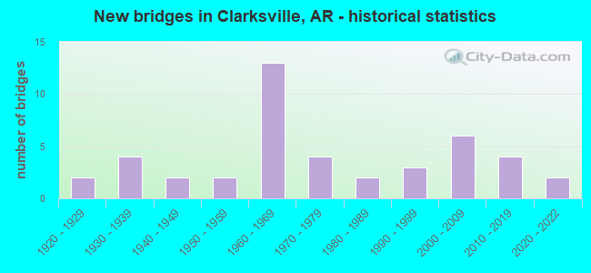
- New bridges - historical statistics
- 21920-1929
- 41930-1939
- 21940-1949
- 21950-1959
- 131960-1969
- 41970-1979
- 21980-1989
- 31990-1999
- 62000-2009
- 42010-2019
- 22020-2022

- Reconstructed bridges - Historical Statistics
- 21950-1959
- 01960-1969
- 11970-1979
- 01980-1989
- 01990-1999
- 02000-2009
- 12010-2019


- Bridge Condition - Deck
- 3.2%Excellent
- 12.9%Very good
- 54.8%Good
- 22.6%Satisfactory
- 6.5%Fair

- Bridge Condition - Superstructure
- 6.5%Excellent
- 6.5%Very good
- 51.6%Good
- 25.8%Satisfactory
- 9.7%Fair

- Bridge Condition - Substructure
- 3.2%Excellent
- 6.5%Very good
- 51.6%Good
- 29.0%Satisfactory
- 9.7%Fair

- Bridge Condition - Channel
- 12.8%Very good
- 74.4%Good
- 10.3%Satisfactory
- 2.6%Fair

- Bridge Condition - Culverts
- 30.8%Very good
- 30.8%Good
- 30.8%Satisfactory
- 7.7%Fair
Find on map >> Show street view
Structure Number: 305, Location: 0.50 MI SO OF THORNTON (Lat: 33.768250, Lng: -92.485167), Route carried "on" structure: Business US 167, Year Built: 1927, Status: Open, Structure Length: 0.79m (2.59ft), Average Daily Traffic: 210 (year 2018), Truck Traffic: 10%, Average Future Daily Traffic: 263 (year 2028), Design Load: H 15, Features Intersected: TURNERS CREEK
Minimum Vertical Clearance: 30+ m (98+ ft), Kilometerpoint: 1.336, Lanes on structure: 2, Owner: State Highway Agency, Approaching Roadway Width: 8.5m (27.9ft), Material/Design: Concrete, Design/Construction: Tee Beam, Number Of Spans In Main Unit: 1, Length of Maximum Span: 7.3m (24.0ft), Curb-To-Curb Width: 6.1m (20.0ft), Out-to-Out Width: 6.9m (22.6ft)
Condition: Deck: Good, Superstructure: Good, Substructure: Good, Channel: Good, Operating Rating: 54.4 metric tons, Method Used To Determine Operating Rating: Load Factor (LF), Inventory Rating: 32.7 metric tons, Method Used To Determine Inventory Rating: Load Factor (LF), Structural Evaluation: Better than present minimum criteria, Deck Geometry: Meets minimum limits, Waterway Adequacy: Better than present minimum criteria, Approach Roadway Alignment: Better than present minimum criteria, Designated Inspection Frequency: Every 24 months, Critical Feature Inspection Frequency: Every 24 months, Inspection Date: June 2020, Deck Structure Type: Concrete Cast-file-Place, Wearing Surface/Protective System: Wearing Surface: Bituminous
Find on map >> Show street view
Structure Number: 358, Location: 12.21 M E Franklin Co L (Lat: 35.472778, Lng: -93.507539), Route carried "on" structure: US 64, Year Built: 1929, Year Reconstructed: 1955, Status: Open, Structure Length: 2.13m (6.99ft), Average Daily Traffic: 6,998 (year 2018), Truck Traffic: 1%, Average Future Daily Traffic: 9,074 (year 2038), Design Load: H 20, Features Intersected: Little Spadra
Minimum Vertical Clearance: 30+ m (98+ ft), Kilometerpoint: 19.645, Lanes on structure: 2, Base Highway Network: Yes, Owner: State Highway Agency, Approaching Roadway Width: 9.4m (30.8ft), Material/Design: Concrete, Design/Construction: Tee Beam, Number Of Spans In Main Unit: 2, Length of Maximum Span: 10.7m (35.1ft), Curb-To-Curb Width: 8.5m (27.9ft), Out-to-Out Width: 9.6m (31.5ft)
Condition: Deck: Good, Superstructure: Good, Substructure: Satisfactory, Channel: Good, Operating Rating: 38.1 metric tons, Method Used To Determine Operating Rating: Load Factor (LF), Inventory Rating: 22.7 metric tons, Method Used To Determine Inventory Rating: Load Factor (LF), Structural Evaluation: Somewhat better than minimum adequacy, Deck Geometry: High priority of replacement, Waterway Adequacy: Equal to present desirable criteria, Approach Roadway Alignment: Better than present minimum criteria, Length Of Structure Improvement: 2.90m (9.51ft), Designated Inspection Frequency: Every 24 months, Critical Feature Inspection Frequency: Every 24 months, Inspection Date: September 2020, Roadway Improvement Cost: $306,000, Total Project Cost: $643,000, Deck Structure Type: Concrete Cast-file-Place, Wearing Surface/Protective System: Wearing Surface: Bituminous
Find on map >> Show street view
Structure Number: 3087, Location: .24 M E Jct of Hwy 103 (Lat: 35.471178, Lng: -93.462269), Route carried "on" structure: US 64, Year Built: 1960, Status: Open, Structure Length: 10.42m (34.19ft), Average Daily Traffic: 11,000 (year 2018), Truck Traffic: 1%, Average Future Daily Traffic: 16,054 (year 2028), Design Load: HS 20, Features Intersected: Spadra Creek
Minimum Vertical Clearance: 30+ m (98+ ft), Kilometerpoint: 0.386, Lanes on structure: 2, Base Highway Network: Yes, Owner: State Highway Agency, Approaching Roadway Width: 12.2m (40.0ft), Material/Design: Concrete, Design/Construction: Slab, Number Of Spans In Main Unit: 10, Length of Maximum Span: 10.4m (34.1ft), Curb or Sidewalk Widths: Left: 1.5m (4.9ft), Right: 1.5m (4.9ft), Curb-To-Curb Width: 12.2m (40.0ft), Out-to-Out Width: 15.3m (50.2ft)
Condition: Deck: Fair, Superstructure: Fair, Substructure: Fair, Channel: Good, Operating Rating: 52.6 metric tons, Method Used To Determine Operating Rating: Load Factor (LF), Inventory Rating: 31.8 metric tons, Method Used To Determine Inventory Rating: Load Factor (LF), Structural Evaluation: Somewhat better than minimum adequacy, Deck Geometry: Somewhat better than minimum adequacy, Waterway Adequacy: Equal to present desirable criteria, Approach Roadway Alignment: Better than present minimum criteria, Designated Inspection Frequency: Every 24 months, Critical Feature Inspection Frequency: Every 24 months, Inspection Date: September 2020, Deck Structure Type: Concrete Cast-file-Place, Wearing Surface/Protective System: Wearing Surface: Monolithic Concrete
Find on map >> Show street view
Structure Number: 3088, Location: .76 MI E JCT OF SH 103 (Lat: 35.471028, Lng: -93.452889), Route carried "on" structure: US 64, Year Built: 1960, Status: Open, Structure Length: 3.81m (12.50ft), Average Daily Traffic: 8,184 (year 2018), Truck Traffic: 1%, Average Future Daily Traffic: 11,372 (year 2028), Design Load: HS 20, Features Intersected: Greenbrier Creek
Minimum Vertical Clearance: 30+ m (98+ ft), Kilometerpoint: 1.223, Lanes on structure: 2, Owner: State Highway Agency, Approaching Roadway Width: 9.4m (30.8ft), Material/Design: Concrete, Design/Construction: Slab, Number Of Spans In Main Unit: 5, Length of Maximum Span: 7.6m (24.9ft), Curb-To-Curb Width: 8.5m (27.9ft), Out-to-Out Width: 10.2m (33.5ft)
Condition: Deck: Satisfactory, Superstructure: Satisfactory, Substructure: Satisfactory, Channel: Good, Operating Rating: 40.8 metric tons, Method Used To Determine Operating Rating: Load Factor (LF), Inventory Rating: 24.5 metric tons, Method Used To Determine Inventory Rating: Load Factor (LF), Structural Evaluation: Equal to present minimum criteria, Deck Geometry: High priority of replacement, Waterway Adequacy: Equal to present desirable criteria, Approach Roadway Alignment: Equal to present desirable criteria, Length Of Structure Improvement: 4.66m (15.29ft), Designated Inspection Frequency: Every 24 months, Critical Feature Inspection Frequency: Every 24 months, Inspection Date: September 2020, Roadway Improvement Cost: $341,000, Total Project Cost: $884,000, Deck Structure Type: Concrete Cast-file-Place, Wearing Surface/Protective System: Wearing Surface: Bituminous
Find on map >> Show street view
Structure Number: 371, Location: JCT I-40 & CO.RD.705 (Lat: 34.820769, Lng: -91.512750), Route carried "on" structure: County highway 705, Year Built: 1965, Status: Open, Structure Length: 10.61m (34.81ft), Average Daily Traffic: 20 (year 2018), Truck Traffic: 1%, Average Future Daily Traffic: 31 (year 2007), Design Load: HS 20, Features Intersected: I -40 LOG 196.32
Minimum Vertical Clearance: 30+ m (98+ ft), Kilometerpoint: 5.180, Lanes on structure: 2, Lanes under structure: 4, Owner: State Highway Agency, Approaching Roadway Width: 7.0m (23.0ft), Skew: 2 degrees, Material/Design: Steel, Design/Construction: Stringer/Multi-beam, Number Of Spans In Main Unit: 6, Length of Maximum Span: 20.4m (66.9ft), Curb or Sidewalk Widths: Left: 0.3m (1.0ft), Right: 0.3m (1.0ft), Curb-To-Curb Width: 6.1m (20.0ft), Out-to-Out Width: 7.5m (24.6ft)
Condition: Deck: Satisfactory, Superstructure: Good, Substructure: Satisfactory, Operating Rating: 46.3 metric tons, Method Used To Determine Operating Rating: Load Factor (LF), Inventory Rating: 27.2 metric tons, Method Used To Determine Inventory Rating: Load Factor (LF), Structural Evaluation: Equal to present minimum criteria, Deck Geometry: Somewhat better than minimum adequacy, Underclear: Meets minimum limits, Approach Roadway Alignment: Equal to present desirable criteria, Designated Inspection Frequency: Every 24 months, Critical Feature Inspection Frequency: Every 24 months, Inspection Date: April 2020, Deck Structure Type: Concrete Cast-file-Place, Wearing Surface/Protective System: Wearing Surface: Monolithic Concrete
Find on map >> Show street view
Structure Number: 3809, Location: 5.21 M NE of Logan Co L (Lat: 35.458000, Lng: -93.482339), Route carried "on" structure: City street 54480, Year Built: 1965, Status: Open, Structure Length: 6.58m (21.59ft), Average Daily Traffic: 7,700 (year 2018), Truck Traffic: 1%, Average Future Daily Traffic: 1,913 (year 2010), Design Load: H 20, Features Intersected: I 40-SEC 21, Facility Carried by Structure: Spadra Rd
Minimum Vertical Clearance: 30+ m (98+ ft), Kilometerpoint: 8.383, Lanes on structure: 2, Lanes under structure: 4, Owner: State Highway Agency, Approaching Roadway Width: 8.8m (28.9ft), Material/Design: Steel, Design/Construction: Stringer/Multi-beam, Number Of Spans In Main Unit: 4, Length of Maximum Span: 20.1m (65.9ft), Curb-To-Curb Width: 7.9m (25.9ft), Out-to-Out Width: 9.6m (31.5ft)
Condition: Deck: Satisfactory, Superstructure: Satisfactory, Substructure: Good, Operating Rating: 54.4 metric tons, Method Used To Determine Operating Rating: Load Factor (LF), Inventory Rating: 32.7 metric tons, Method Used To Determine Inventory Rating: Load Factor (LF), Structural Evaluation: Equal to present minimum criteria, Deck Geometry: High priority of corrective action, Underclear: High priority of corrective action, Approach Roadway Alignment: Equal to present desirable criteria, Designated Inspection Frequency: Every 24 months, Critical Feature Inspection Frequency: Every 24 months, Inspection Date: Febuary 2022, Deck Structure Type: Concrete Cast-file-Place, Wearing Surface/Protective System: Wearing Surface: Monolithic Concrete
Find on map >> Show street view
Structure Number: 3861, Location: 2.0 M East Of SH 103 (Lat: 35.451731, Lng: -93.434211), Route carried "on" structure: County highway 40, Year Built: 1965, Status: Open, Structure Length: 6.74m (22.11ft), Average Daily Traffic: 374 (year 2006), Truck Traffic: 1%, Average Future Daily Traffic: 1,003 (year 2026), Design Load: H 15, Features Intersected: I 40-SEC 21, Facility Carried by Structure: Big Danger Rd.
Minimum Vertical Clearance: 30+ m (98+ ft), Kilometerpoint: 0.982, Lanes on structure: 2, Lanes under structure: 4, Owner: State Highway Agency, Approaching Roadway Width: 8.2m (26.9ft), Skew: 1 degrees, Material/Design: Steel, Design/Construction: Stringer/Multi-beam, Number Of Spans In Main Unit: 4, Length of Maximum Span: 20.4m (66.9ft), Curb-To-Curb Width: 7.3m (24.0ft), Out-to-Out Width: 8.7m (28.5ft)
Condition: Deck: Good, Superstructure: Satisfactory, Substructure: Good, Operating Rating: 46.3 metric tons, Method Used To Determine Operating Rating: Load Factor (LF), Inventory Rating: 27.2 metric tons, Method Used To Determine Inventory Rating: Load Factor (LF), Structural Evaluation: Equal to present minimum criteria, Deck Geometry: Somewhat better than minimum adequacy, Underclear: High priority of corrective action, Approach Roadway Alignment: Equal to present desirable criteria, Designated Inspection Frequency: Every 24 months, Critical Feature Inspection Frequency: Every 24 months, Inspection Date: Febuary 2022, Deck Structure Type: Concrete Cast-file-Place, Wearing Surface/Protective System: Wearing Surface: Monolithic Concrete
Find on map >> Show street view
Structure Number: 4145, Location: 4.45 M N CORD 77 & SH 103 (Lat: 35.538472, Lng: -93.478056), Route carried "on" structure: County highway 77, Year Built: 1958, Status: Open, Structure Length: 4.27m (14.01ft), Average Daily Traffic: 74 (year 2018), Truck Traffic: 1%, Average Future Daily Traffic: 182 (year 2007), Design Load: H 15, Features Intersected: Spadra Creek, Facility Carried by Structure: CR 3451
Minimum Vertical Clearance: 30+ m (98+ ft), Kilometerpoint: 7.160, Lanes on structure: 1, Owner: County Highway Agency, Approaching Roadway Width: 5.5m (18.0ft), Material/Design: Concrete, Design/Construction: Slab, Number Of Spans In Main Unit: 5, Length of Maximum Span: 8.5m (27.9ft), Curb or Sidewalk Widths: Left: 0.2m (0.7ft), Right: 0.2m (0.7ft), Curb-To-Curb Width: 4.3m (14.1ft), Out-to-Out Width: 4.7m (15.4ft)
Condition: Deck: Good, Superstructure: Good, Substructure: Good, Channel: Good, Operating Rating: 50.8 metric tons, Method Used To Determine Operating Rating: Load Factor (LF), Inventory Rating: 29.9 metric tons, Method Used To Determine Inventory Rating: Load Factor (LF), Structural Evaluation: Better than present minimum criteria, Deck Geometry: Equal to present minimum criteria, Waterway Adequacy: Equal to present minimum criteria, Approach Roadway Alignment: Equal to present desirable criteria, Length Of Structure Improvement: 5.15m (16.90ft), Designated Inspection Frequency: Every 24 months, Critical Feature Inspection Frequency: Every 24 months, Inspection Date: Febuary 2021, Roadway Improvement Cost: $109,000, Total Project Cost: $375,000, Deck Structure Type: Concrete Cast-file-Place, Wearing Surface/Protective System: Wearing Surface: Monolithic Concrete
Find on map >> Show street view
Structure Number: 5017, Location: 10.14 M E Franklin Co Lin (Lat: 35.476631, Lng: -93.547181), Route carried "on" structure: State highway 352, Year Built: 1968, Status: Open, Structure Length: 9.39m (30.81ft), Average Daily Traffic: 1,072 (year 2018), Truck Traffic: 4%, Average Future Daily Traffic: 2,007 (year 2028), Design Load: H 20, Features Intersected: I 40-SEC 21
Minimum Vertical Clearance: 30+ m (98+ ft), Kilometerpoint: 16.319, Lanes on structure: 2, Lanes under structure: 4, Owner: State Highway Agency, Approaching Roadway Width: 10.4m (34.1ft), Skew: 3 degrees, Material/Design: Steel, Design/Construction: Stringer/Multi-beam, Number Of Spans In Main Unit: 4, Length of Maximum Span: 30.2m (99.1ft), Curb or Sidewalk Widths: Left: 0.2m (0.7ft), Right: 0.2m (0.7ft), Curb-To-Curb Width: 10.4m (34.1ft), Out-to-Out Width: 11.4m (37.4ft)
Condition: Deck: Good, Superstructure: Satisfactory, Substructure: Satisfactory, Operating Rating: 54.4 metric tons, Method Used To Determine Operating Rating: Load Factor (LF), Inventory Rating: 32.7 metric tons, Method Used To Determine Inventory Rating: Load Factor (LF), Structural Evaluation: Equal to present minimum criteria, Deck Geometry: Equal to present minimum criteria, Underclear: Somewhat better than minimum adequacy, Approach Roadway Alignment: Equal to present minimum criteria, Designated Inspection Frequency: Every 24 months, Critical Feature Inspection Frequency: Every 24 months, Inspection Date: Febuary 2022, Deck Structure Type: Concrete Cast-file-Place, Wearing Surface/Protective System: Wearing Surface: Monolithic Concrete
Find on map >> Show street view
Structure Number: 56, Location: 1.5 MI SO JCT 194 (Lat: 35.390314, Lng: -93.530164), Route carried "on" structure: State highway 109, Year Built: 1980, Status: Open, Structure Length: 260.21m (853.71ft), Average Daily Traffic: 3,800 (year 2018), Truck Traffic: 17%, Average Future Daily Traffic: 5,101 (year 2028), Design Load: HS 20, Features Intersected: ARKANSAS RIVER
Minimum Vertical Clearance: 30+ m (98+ ft), Kilometerpoint: 12.632, Lanes on structure: 2, Owner: State Highway Agency, Approaching Roadway Width: 12.2m (40.0ft), Navigation Control: Yes ( Vertical Clearance: 15.7m (51.5ft), Horizontal Clearance: 76.2m (250.0ft)), Material/Design: Steel continuous, Design/Construction: Girder and Floorbeam System, Number Of Spans In Main Unit: 3, Number Of Approach Spans: 57, Length of Maximum Span: 125.0m (410.1ft), Curb-To-Curb Width: 9.1m (29.9ft), Out-to-Out Width: 10.0m (32.8ft)
Condition: Deck: Good, Superstructure: Satisfactory, Substructure: Good, Channel: Good, Operating Rating: 54.4 metric tons, Method Used To Determine Operating Rating: Load Factor (LF), Inventory Rating: 32.7 metric tons, Method Used To Determine Inventory Rating: Load Factor (LF), Structural Evaluation: Equal to present minimum criteria, Deck Geometry: Meets minimum limits, Waterway Adequacy: Equal to present desirable criteria, Approach Roadway Alignment: Equal to present desirable criteria, Designated Inspection Frequency: Every 24 months, Critical Feature Inspection Frequency: Every 24 months, Inspection Date: April 2020, Critical Feature Inspection Date: April 2021, Deck Structure Type: Concrete Cast-file-Place, Wearing Surface/Protective System: Wearing Surface: Monolithic Concrete
Find on map >> Show street view
Structure Number: 597, Location: 5.84 MI SE JCT SH 48 (Lat: 34.005428, Lng: -92.498008), Route carried "on" structure: State highway 229, Year Built: 1983, Status: Open, Structure Length: 2.74m (8.99ft), Average Daily Traffic: 353 (year 2018), Truck Traffic: 18%, Average Future Daily Traffic: 290 (year 2028), Design Load: H 20, Features Intersected: PICKETT CREEK
Minimum Vertical Clearance: 30+ m (98+ ft), Kilometerpoint: 22.128, Lanes on structure: 2, Owner: State Highway Agency, Approaching Roadway Width: 8.5m (27.9ft), Material/Design: Concrete, Design/Construction: Slab, Number Of Spans In Main Unit: 3, Length of Maximum Span: 9.1m (29.9ft), Curb-To-Curb Width: 8.5m (27.9ft), Out-to-Out Width: 9.4m (30.8ft)
Condition: Deck: Good, Superstructure: Good, Substructure: Very good, Channel: Good, Operating Rating: 53.5 metric tons, Method Used To Determine Operating Rating: Load Factor (LF), Inventory Rating: 32.7 metric tons, Method Used To Determine Inventory Rating: Load Factor (LF), Structural Evaluation: Better than present minimum criteria, Deck Geometry: Equal to present minimum criteria, Waterway Adequacy: Equal to present desirable criteria, Approach Roadway Alignment: Equal to present desirable criteria, Designated Inspection Frequency: Every 24 months, Critical Feature Inspection Frequency: Every 24 months, Inspection Date: August 2020, Deck Structure Type: Concrete Cast-file-Place, Wearing Surface/Protective System: Wearing Surface: Monolithic Concrete
Find on map >> Show street view
Structure Number: 6377, Location: 1.6 M N Jct US 64&SH 103 (Lat: 35.489189, Lng: -93.477592), Route carried "on" structure: State highway 103, Year Built: 1992, Status: Open, Structure Length: 2.80m (9.19ft), Average Daily Traffic: 1,100 (year 2018), Truck Traffic: 1%, Average Future Daily Traffic: 1,605 (year 2028), Features Intersected: Wolf Creek
Minimum Vertical Clearance: 30+ m (98+ ft), Kilometerpoint: 2.494, Lanes on structure: 2, Owner: State Highway Agency, Approaching Roadway Width: 11.6m (38.1ft), Material/Design: Steel continuous, Design/Construction: Stringer/Multi-beam, Number Of Spans In Main Unit: 3, Length of Maximum Span: 9.1m (29.9ft), Curb or Sidewalk Widths: Left: 0.4m (1.3ft), Right: 0.4m (1.3ft), Curb-To-Curb Width: 9.1m (29.9ft), Out-to-Out Width: 10.0m (32.8ft)
Condition: Deck: Very good, Superstructure: Very good, Substructure: Good, Channel: Good, Operating Rating: 54.4 metric tons, Method Used To Determine Operating Rating: Load Factor (LF), Inventory Rating: 32.7 metric tons, Method Used To Determine Inventory Rating: Load Factor (LF), Structural Evaluation: Better than present minimum criteria, Deck Geometry: Somewhat better than minimum adequacy, Waterway Adequacy: Equal to present minimum criteria, Approach Roadway Alignment: Equal to present desirable criteria, Designated Inspection Frequency: Every 24 months, Critical Feature Inspection Frequency: Every 24 months, Inspection Date: May 2020, Deck Structure Type: Concrete Cast-file-Place, Wearing Surface/Protective System: Wearing Surface: Monolithic Concrete
Find on map >> Show street view
Structure Number: 6378, Location: 2.4 M N Jct US 64 (Lat: 35.497225, Lng: -93.489289), Route carried "on" structure: State highway 103, Year Built: 1992, Status: Open, Structure Length: 3.72m (12.20ft), Average Daily Traffic: 1,100 (year 2018), Truck Traffic: 1%, Average Future Daily Traffic: 1,605 (year 2028), Features Intersected: Burt Creek
Minimum Vertical Clearance: 30+ m (98+ ft), Kilometerpoint: 3.879, Lanes on structure: 2, Owner: State Highway Agency, Approaching Roadway Width: 11.6m (38.1ft), Skew: 4 degrees, Material/Design: Steel, Design/Construction: Stringer/Multi-beam, Number Of Spans In Main Unit: 3, Length of Maximum Span: 12.2m (40.0ft), Curb or Sidewalk Widths: Left: 0.4m (1.3ft), Right: 0.4m (1.3ft), Curb-To-Curb Width: 9.1m (29.9ft), Out-to-Out Width: 10.0m (32.8ft)
Condition: Deck: Good, Superstructure: Good, Substructure: Good, Channel: Good, Operating Rating: 54.4 metric tons, Method Used To Determine Operating Rating: Load Factor (LF), Inventory Rating: 32.7 metric tons, Method Used To Determine Inventory Rating: Load Factor (LF), Structural Evaluation: Better than present minimum criteria, Deck Geometry: Somewhat better than minimum adequacy, Waterway Adequacy: Equal to present desirable criteria, Approach Roadway Alignment: Equal to present minimum criteria, Designated Inspection Frequency: Every 24 months, Critical Feature Inspection Frequency: Every 24 months, Inspection Date: May 2020, Deck Structure Type: Concrete Cast-file-Place, Wearing Surface/Protective System: Wearing Surface: Monolithic Concrete
Find on map >> Show street view
Structure Number: 6738, Location: 2.2 M S I-40 Jct (Lat: 35.429997, Lng: -93.495278), Route carried "on" structure: City street 54480, Year Built: 2000, Status: Open, Structure Length: 8.08m (26.51ft), Average Daily Traffic: 3,600 (year 2018), Truck Traffic: 4%, Average Future Daily Traffic: 4,415 (year 2018), Design Load: HS 20, Features Intersected: LIittle Spadra Creek, Facility Carried by Structure: S. Crawford St.
Minimum Vertical Clearance: 30+ m (98+ ft), Kilometerpoint: 4.971, Lanes on structure: 2, Owner: City or Municipal Highway Agency, Approaching Roadway Width: 14.0m (45.9ft), Skew: 2 degrees, Material/Design: Steel continuous, Design/Construction: Stringer/Multi-beam, Number Of Spans In Main Unit: 3, Length of Maximum Span: 29.9m (98.1ft), Curb-To-Curb Width: 12.0m (39.4ft), Out-to-Out Width: 13.0m (42.7ft)
Condition: Deck: Good, Superstructure: Very good, Substructure: Good, Channel: Very good, Operating Rating: 54.4 metric tons, Method Used To Determine Operating Rating: Load Factor (LF), Inventory Rating: 32.7 metric tons, Method Used To Determine Inventory Rating: Load Factor (LF), Structural Evaluation: Better than present minimum criteria, Deck Geometry: Somewhat better than minimum adequacy, Waterway Adequacy: Equal to present desirable criteria, Approach Roadway Alignment: Better than present minimum criteria, Designated Inspection Frequency: Every 24 months, Critical Feature Inspection Frequency: Every 24 months, Inspection Date: May 2020, Deck Structure Type: Concrete Cast-file-Place, Wearing Surface/Protective System: Wearing Surface: Monolithic Concrete, Deck Protection: Epoxy Coated Reinforcing
Find on map >> Show street view
Structure Number: 727, Location: 1.38 Mi S of Jct of SH 64 (Lat: 35.452181, Lng: -93.465261), Route carried "on" structure: State highway 103, Year Built: 2015, Status: Open, Structure Length: 7.01m (23.00ft), Average Daily Traffic: 5,355 (year 2018), Truck Traffic: 3%, Average Future Daily Traffic: 20,000 (year 2033), Design Load: HL 93, Features Intersected: I-40 Main Lanes Sec 21
Minimum Vertical Clearance: 30+ m (98+ ft), Kilometerpoint: 2.591, Lanes on structure: 5, Lanes under structure: 6, Base Highway Network: Yes (Inventory Route: 1, Subroute: 1), Owner: State Highway Agency, Approaching Roadway Width: 17.7m (58.1ft), Material/Design: Steel continuous, Design/Construction: Stringer/Multi-beam, Number Of Spans In Main Unit: 3, Length of Maximum Span: 35.1m (115.2ft), Curb or Sidewalk Widths: Left: 2.0m (6.6ft), Right: 2.0m (6.6ft), Curb-To-Curb Width: 17.7m (58.1ft), Out-to-Out Width: 22.6m (74.1ft)
Condition: Deck: Very good, Superstructure: Excellent, Substructure: Very good, Operating Rating: 54.4 metric tons, Method Used To Determine Operating Rating: Load and Resistance Factor (LRFR), Inventory Rating: 32.7 metric tons, Method Used To Determine Inventory Rating: Load and Resistance Factor (LRFR), Structural Evaluation: Equal to present desirable criteria, Deck Geometry: High priority of replacement, Underclear: Better than present minimum criteria, Approach Roadway Alignment: Equal to present desirable criteria, Designated Inspection Frequency: Every 24 months, Critical Feature Inspection Frequency: Every 24 months, Inspection Date: December 2021, Deck Structure Type: Concrete Cast-file-Place, Wearing Surface/Protective System: Wearing Surface: Monolithic Concrete, Deck Protection: Epoxy Coated Reinforcing
Find on map >> Show street view
Structure Number: 1435, Location: 0.31 MI. S. of I-40 (Lat: 35.473167, Lng: -93.545831), Route carried "on" structure: County highway 15, Year Built: 1942, Status: Open, Structure Length: 1.13m (3.71ft), Average Daily Traffic: 490 (year 2018), Truck Traffic: 1%, Average Future Daily Traffic: 214 (year 2007), Features Intersected: Hogskin Creek, Facility Carried by Structure: CR 2301
Minimum Vertical Clearance: 30+ m (98+ ft), Kilometerpoint: 0.499, Lanes on structure: 2, Owner: County Highway Agency, Approaching Roadway Width: 6.1m (20.0ft), Material/Design: Steel, Design/Construction: Stringer/Multi-beam, Number Of Spans In Main Unit: 1, Length of Maximum Span: 11.3m (37.1ft), Curb-To-Curb Width: 6.1m (20.0ft), Out-to-Out Width: 6.6m (21.7ft)
Condition: Deck: Satisfactory, Superstructure: Fair, Substructure: Satisfactory, Channel: Good, Operating Rating: 44.5 metric tons, Method Used To Determine Operating Rating: Allowable Stress (AS), Inventory Rating: 26.3 metric tons, Method Used To Determine Inventory Rating: Allowable Stress (AS), Structural Evaluation: Somewhat better than minimum adequacy, Deck Geometry: High priority of corrective action, Waterway Adequacy: Equal to present desirable criteria, Approach Roadway Alignment: Equal to present desirable criteria, Designated Inspection Frequency: Every 24 months, Critical Feature Inspection Frequency: Every 24 months, Inspection Date: Febuary 2021, Deck Structure Type: Concrete Cast-file-Place, Wearing Surface/Protective System: Wearing Surface: Monolithic Concrete
Find on map >> Show street view
Structure Number: 14357, Location: 1.39 NO I 40 (Lat: 35.496469, Lng: -93.549028), Route carried "on" structure: County highway 23, Year Built: 1942, Status: Open, Structure Length: 1.07m (3.51ft), Average Daily Traffic: 1,219 (year 2018), Truck Traffic: 1%, Average Future Daily Traffic: 326 (year 2007), Features Intersected: Little Spadra Creek, Facility Carried by Structure: CR 3291
Minimum Vertical Clearance: 30+ m (98+ ft), Kilometerpoint: 2.237, Lanes on structure: 2, Owner: County Highway Agency, Approaching Roadway Width: 6.7m (22.0ft), Material/Design: Steel, Design/Construction: Stringer/Multi-beam, Number Of Spans In Main Unit: 2, Length of Maximum Span: 5.5m (18.0ft), Curb or Sidewalk Widths: Left: 0.4m (1.3ft), Right: 0.4m (1.3ft), Curb-To-Curb Width: 6.1m (20.0ft), Out-to-Out Width: 6.6m (21.7ft)
Condition: Deck: Satisfactory, Superstructure: Satisfactory, Substructure: Satisfactory, Channel: Good, Operating Rating: 39.0 metric tons, Method Used To Determine Operating Rating: Load Factor (LF), Inventory Rating: 23.6 metric tons, Method Used To Determine Inventory Rating: Load Factor (LF), Structural Evaluation: Equal to present minimum criteria, Deck Geometry: High priority of replacement, Waterway Adequacy: Equal to present desirable criteria, Approach Roadway Alignment: Equal to present desirable criteria, Designated Inspection Frequency: Every 24 months, Critical Feature Inspection Frequency: Every 24 months, Inspection Date: March 2021, Deck Structure Type: Concrete Cast-file-Place, Wearing Surface/Protective System: Wearing Surface: Bituminous
Find on map >> Show street view
Structure Number: 14369, Location: 4.1 M N Jct 103 (Lat: 35.534500, Lng: -93.476939), Route carried "on" structure: County highway 77, Year Built: 1978, Status: Open, Structure Length: 0.91m (2.99ft), Average Daily Traffic: 904 (year 2018), Truck Traffic: 1%, Average Future Daily Traffic: 182 (year 2007), Features Intersected: Curtis Creek, Facility Carried by Structure: CR 3451
Minimum Vertical Clearance: 30+ m (98+ ft), Kilometerpoint: 6.613, Lanes on structure: 2, Owner: County Highway Agency, Approaching Roadway Width: 7.3m (24.0ft), Skew: 1 degrees, Material/Design: Concrete, Design/Construction: Channel Beam, Number Of Spans In Main Unit: 2, Length of Maximum Span: 4.6m (15.1ft), Curb or Sidewalk Widths: Left: 0.2m (0.7ft), Right: 0.2m (0.7ft), Curb-To-Curb Width: 6.3m (20.7ft), Out-to-Out Width: 6.6m (21.7ft)
Condition: Deck: Good, Superstructure: Good, Substructure: Fair, Channel: Good, Operating Rating: 35.4 metric tons, Method Used To Determine Operating Rating: Load Factor (LF), Inventory Rating: 21.8 metric tons, Method Used To Determine Inventory Rating: Load Factor (LF), Structural Evaluation: Somewhat better than minimum adequacy, Deck Geometry: High priority of corrective action, Waterway Adequacy: Better than present minimum criteria, Approach Roadway Alignment: Meets minimum limits, Designated Inspection Frequency: Every 24 months, Critical Feature Inspection Frequency: Every 24 months, Inspection Date: Febuary 2021, Deck Structure Type: Concrete Precast Panels, Wearing Surface/Protective System: Wearing Surface: Monolithic Concrete
Find on map >> Show street view
Structure Number: 1437, Location: 4.72 M N CR77 & SH103 (Lat: 35.541667, Lng: -93.481528), Route carried "on" structure: County highway 77, Year Built: 1930, Year Reconstructed: 1970, Status: Open, Structure Length: 1.37m (4.49ft), Average Daily Traffic: 904 (year 2018), Truck Traffic: 1%, Average Future Daily Traffic: 182 (year 2007), Features Intersected: Rock Creek, Facility Carried by Structure: CR 3451
Minimum Vertical Clearance: 30+ m (98+ ft), Kilometerpoint: 7.594, Lanes on structure: 2, Owner: County Highway Agency, Approaching Roadway Width: 8.5m (27.9ft), Material/Design: Concrete, Design/Construction: Channel Beam, Number Of Spans In Main Unit: 2, Length of Maximum Span: 7.9m (25.9ft), Curb or Sidewalk Widths: Left: 0.2m (0.7ft), Right: 0.2m (0.7ft), Curb-To-Curb Width: 7.9m (25.9ft), Out-to-Out Width: 8.5m (27.9ft)
Condition: Deck: Good, Superstructure: Good, Substructure: Satisfactory, Channel: Good, Operating Rating: 35.4 metric tons, Method Used To Determine Operating Rating: Load Factor (LF), Inventory Rating: 21.8 metric tons, Method Used To Determine Inventory Rating: Load Factor (LF), Structural Evaluation: Somewhat better than minimum adequacy, Deck Geometry: Somewhat better than minimum adequacy, Waterway Adequacy: Better than present minimum criteria, Approach Roadway Alignment: Meets minimum limits, Length Of Structure Improvement: 2.10m (6.89ft), Designated Inspection Frequency: Every 24 months, Critical Feature Inspection Frequency: Every 24 months, Inspection Date: Febuary 2021, Roadway Improvement Cost: $109,000, Total Project Cost: $236,000, Deck Structure Type: Concrete Precast Panels, Wearing Surface/Protective System: Wearing Surface: Bituminous
Find on map >> Show street view
Structure Number: 14372, Location: 1.07 M W of hwy. 21 (Lat: 35.483469, Lng: -93.447069), Route carried "on" structure: County highway 82, Year Built: 1976, Status: Posted for load, Structure Length: 0.94m (3.08ft), Average Daily Traffic: 111 (year 2018), Truck Traffic: 1%, Average Future Daily Traffic: 84 (year 2007), Features Intersected: Spadra Creek, Facility Carried by Structure: CR 3481
Minimum Vertical Clearance: 30+ m (98+ ft), Kilometerpoint: 1.722, Lanes on structure: 1, Owner: County Highway Agency, Approaching Roadway Width: 4.8m (15.7ft), Material/Design: Concrete, Design/Construction: Channel Beam, Number Of Spans In Main Unit: 1, Length of Maximum Span: 9.4m (30.8ft), Curb-To-Curb Width: 4.8m (15.7ft), Out-to-Out Width: 5.4m (17.7ft)
Condition: Deck: Good, Superstructure: Fair, Substructure: Fair, Channel: Satisfactory, Operating Rating: 27.2 metric tons, Method Used To Determine Operating Rating: Load Factor (LF), Inventory Rating: 16.3 metric tons, Method Used To Determine Inventory Rating: Load Factor (LF), Structural Evaluation: Somewhat better than minimum adequacy, Deck Geometry: High priority of corrective action, Waterway Adequacy: Better than present minimum criteria, Approach Roadway Alignment: Equal to present desirable criteria, Bridge Posting: Required (Relationship of Operating Rating to Maximum Legal Load: 30.0 - 39.9% below), Length Of Structure Improvement: 1.65m (5.41ft), Designated Inspection Frequency: Every 24 months, Critical Feature Inspection Frequency: Every 24 months, Inspection Date: October 2021, Roadway Improvement Cost: $109,000, Total Project Cost: $215,000, Deck Structure Type: Concrete Precast Panels, Wearing Surface/Protective System: Wearing Surface: Bituminous
Find on map >> Show street view
Structure Number: 14823, Location: 1.5 MI N OF DUBLIN, Logan (Lat: 35.383583, Lng: -93.471167), Route carried "on" structure: County highway 92, Year Built: 1973, Status: Open, Structure Length: 0.73m (2.40ft), Average Daily Traffic: 857 (year 2018), Truck Traffic: 1%, Average Future Daily Traffic: 142 (year 2007), Design Load: H 10, Features Intersected: Mud Branch Logan County, Facility Carried by Structure: Dublin Road
Minimum Vertical Clearance: 30+ m (98+ ft), Kilometerpoint: 4.714, Lanes on structure: 1, Owner: County Highway Agency, Approaching Roadway Width: 6.7m (22.0ft), Skew: 4 degrees, Material/Design: Concrete, Design/Construction: Culvert, Number Of Spans In Main Unit: 2, Length of Maximum Span: 3.7m (12.1ft), Curb-To-Curb Width: 5.3m (17.4ft), Out-to-Out Width: 5.3m (17.4ft)
Condition: Channel: Fair, Culverts: Satisfactory, Operating Rating: 24.5 metric tons, Method Used To Determine Operating Rating: Load Factor (LF), Inventory Rating: 14.5 metric tons, Method Used To Determine Inventory Rating: Load Factor (LF), Structural Evaluation: Meets minimum limits, Deck Geometry: High priority of replacement, Waterway Adequacy: Equal to present minimum criteria, Approach Roadway Alignment: Somewhat better than minimum adequacy, Length Of Structure Improvement: 0.73m (2.40ft), Designated Inspection Frequency: Every 24 months, Critical Feature Inspection Frequency: Every 24 months, Inspection Date: January 2021, Roadway Improvement Cost: $131,000, Total Project Cost: $197,000
Find on map >> Show street view
Structure Number: 19228, Location: 0.28 E SH 103 (Lat: 35.472128, Lng: -93.461378), Route carried "on" structure: City street 10580, Year Built: 1968, Status: Open, Structure Length: 9.14m (29.99ft), Average Daily Traffic: 6,400 (year 2018), Truck Traffic: 1%, Average Future Daily Traffic: 3,492 (year 2007), Design Load: HS 20, Features Intersected: Spadra Creek, Facility Carried by Structure: Cherry Street
Minimum Vertical Clearance: 30+ m (98+ ft), Kilometerpoint: 0.451, Lanes on structure: 2, Owner: City or Municipal Highway Agency, Approaching Roadway Width: 8.5m (27.9ft), Material/Design: Steel continuous, Design/Construction: Stringer/Multi-beam, Number Of Spans In Main Unit: 4, Length of Maximum Span: 25.6m (84.0ft), Curb or Sidewalk Widths: Left: 0.5m (1.6ft), Right: 2.8m (9.2ft), Curb-To-Curb Width: 7.3m (24.0ft), Out-to-Out Width: 10.6m (34.8ft)
Condition: Deck: Fair, Superstructure: Satisfactory, Substructure: Good, Channel: Good, Operating Rating: 54.4 metric tons, Method Used To Determine Operating Rating: Load Factor (LF), Inventory Rating: 32.7 metric tons, Method Used To Determine Inventory Rating: Load Factor (LF), Structural Evaluation: Equal to present minimum criteria, Deck Geometry: High priority of replacement, Waterway Adequacy: Equal to present desirable criteria, Approach Roadway Alignment: Equal to present desirable criteria, Designated Inspection Frequency: Every 24 months, Critical Feature Inspection Frequency: Every 24 months, Inspection Date: March 2021, Deck Structure Type: Concrete Cast-file-Place, Wearing Surface/Protective System: Wearing Surface: Monolithic Concrete
Find on map >> Show street view
Structure Number: 19229, Location: .76 M E Cherry St&Hwy 103 (Lat: 35.471908, Lng: -93.453025), Route carried "on" structure: City street 10580, Year Built: 1970, Status: Open, Structure Length: 1.37m (4.49ft), Average Daily Traffic: 6,400 (year 2018), Truck Traffic: 1%, Average Future Daily Traffic: 3,492 (year 2007), Features Intersected: Greenbriar Creek, Facility Carried by Structure: Cherry St.
Minimum Vertical Clearance: 30+ m (98+ ft), Kilometerpoint: 1.239, Lanes on structure: 2, Owner: City or Municipal Highway Agency, Approaching Roadway Width: 8.5m (27.9ft), Material/Design: Concrete, Design/Construction: Channel Beam, Number Of Spans In Main Unit: 1, Length of Maximum Span: 13.7m (44.9ft), Curb or Sidewalk Widths: Left: 0.4m (1.3ft), Right: 2.5m (8.2ft), Curb-To-Curb Width: 8.4m (27.6ft), Out-to-Out Width: 13.3m (43.6ft)
Condition: Deck: Very good, Superstructure: Good, Substructure: Good, Channel: Good, Operating Rating: 36.3 metric tons, Method Used To Determine Operating Rating: Load Factor (LF), Inventory Rating: 21.8 metric tons, Method Used To Determine Inventory Rating: Load Factor (LF), Structural Evaluation: Somewhat better than minimum adequacy, Deck Geometry: High priority of replacement, Waterway Adequacy: Better than present minimum criteria, Approach Roadway Alignment: Equal to present minimum criteria, Designated Inspection Frequency: Every 24 months, Critical Feature Inspection Frequency: Every 24 months, Inspection Date: Febuary 2022, Deck Structure Type: Concrete Precast Panels, Wearing Surface/Protective System: Wearing Surface: Bituminous
Find on map >> Show street view
Structure Number: 20842, Location: 0.15 Mi. N. SH 64 (Lat: 35.474608, Lng: -93.510278), Route carried "on" structure: City street 27690, Year Built: 1990, Status: Open, Structure Length: 0.67m (2.20ft), Average Daily Traffic: 28 (year 2018), Truck Traffic: 1%, Average Future Daily Traffic: 316 (year 2009), Features Intersected: Little Spadra Creek, Facility Carried by Structure: Hudson Springs Rd
Minimum Vertical Clearance: 30+ m (98+ ft), Kilometerpoint: 0.241, Lanes on structure: 2, Owner: City or Municipal Highway Agency, Approaching Roadway Width: 6.7m (22.0ft), Material/Design: Steel, Design/Construction: Culvert, Number Of Spans In Main Unit: 2, Length of Maximum Span: 3.0m (9.8ft), Curb-To-Curb Width: 8.5m (27.9ft), Out-to-Out Width: 9.2m (30.2ft)
Condition: Channel: Satisfactory, Culverts: Fair, Operating Rating: 54.4 metric tons, Method Used To Determine Operating Rating: Load Factor (LF), Inventory Rating: 32.7 metric tons, Method Used To Determine Inventory Rating: Load Factor (LF), Structural Evaluation: Somewhat better than minimum adequacy, Deck Geometry: Better than present minimum criteria, Waterway Adequacy: Equal to present desirable criteria, Approach Roadway Alignment: Equal to present desirable criteria, Designated Inspection Frequency: Every 24 months, Critical Feature Inspection Frequency: Every 24 months, Inspection Date: March 2021
Find on map >> Show street view
Structure Number: 24007, Location: 0.25 M North Jct SH123 (Lat: 35.468178, Lng: -93.440569), Route carried "on" structure: City street 42700, Year Built: 2015, Status: Open, Structure Length: 2.01m (6.59ft), Average Daily Traffic: 75 (year 2018), Truck Traffic: 1%, Average Future Daily Traffic: 85 (year 2038), Features Intersected: Greenbrier Creek, Facility Carried by Structure: Palmer Rd.
Minimum Vertical Clearance: 30.44m (99.87ft), Kilometerpoint: 0.402, Lanes on structure: 2, Owner: City or Municipal Highway Agency, Approaching Roadway Width: 9.3m (30.5ft), Material/Design: Concrete, Design/Construction: Culvert, Number Of Spans In Main Unit: 6, Length of Maximum Span: 3.0m (9.8ft), Curb or Sidewalk Widths: Left: 3.0m (9.8ft), Right: 0.0m
Condition: Channel: Good, Culverts: Good, Operating Rating: 54.4 metric tons, Method Used To Determine Operating Rating: Load and Resistance Factor (LRFR), Inventory Rating: 32.7 metric tons, Method Used To Determine Inventory Rating: Load and Resistance Factor (LRFR), Structural Evaluation: Better than present minimum criteria, Waterway Adequacy: Equal to present desirable criteria, Approach Roadway Alignment: Equal to present desirable criteria, Designated Inspection Frequency: Every 24 months, Critical Feature Inspection Frequency: Every 24 months, Inspection Date: September 2020
Find on map >> Show street view
Structure Number: 24021, Location: 0.90 M E Jct CR 77 & 74 (Lat: 35.532028, Lng: -93.464919), Route carried "on" structure: County highway 74, Year Built: 2018, Status: Open, Structure Length: 2.83m (9.28ft), Average Daily Traffic: 74 (year 2018), Truck Traffic: 1%, Average Future Daily Traffic: 110 (year 2038), Features Intersected: Spadra Creek, Facility Carried by Structure: CR 3566
Minimum Vertical Clearance: 30.44m (99.87ft), Kilometerpoint: 1.448, Lanes on structure: 2, Owner: County Highway Agency, Approaching Roadway Width: 6.2m (20.3ft), Material/Design: Concrete, Design/Construction: Channel Beam, Number Of Spans In Main Unit: 3, Length of Maximum Span: 8.8m (28.9ft), Curb-To-Curb Width: 6.4m (21.0ft), Out-to-Out Width: 6.8m (22.3ft)
Condition: Deck: Very good, Superstructure: Good, Substructure: Good, Channel: Very good, Operating Rating: 54.4 metric tons, Method Used To Determine Operating Rating: Load Factor (LF), Inventory Rating: 32.7 metric tons, Method Used To Determine Inventory Rating: Load Factor (LF), Structural Evaluation: Better than present minimum criteria, Deck Geometry: Somewhat better than minimum adequacy, Waterway Adequacy: Equal to present desirable criteria, Approach Roadway Alignment: Equal to present minimum criteria, Designated Inspection Frequency: Every 24 months, Critical Feature Inspection Frequency: Every 24 months, Inspection Date: October 2020, Deck Structure Type: Concrete Precast Panels, Wearing Surface/Protective System: Wearing Surface: Monolithic Concrete
Find on map >> Show street view
Structure Number: 24048, Location: 0.88 M W Jct Crawford Rd (Lat: 35.461939, Lng: -93.497219), Route carried "on" structure: City street 11480, Year Built: 2018, Status: Open, Structure Length: 5.55m (18.21ft), Average Daily Traffic: 2,700 (year 2019), Truck Traffic: 1%, Average Future Daily Traffic: 3,240 (year 2040), Design Load: HL 93, Features Intersected: Little Willet Creek, Facility Carried by Structure: Clark Rd
Minimum Vertical Clearance: 30.44m (99.87ft), Kilometerpoint: 1.416, Lanes on structure: 2, Owner: City or Municipal Highway Agency, Approaching Roadway Width: 10.9m (35.8ft), Material/Design: Steel, Design/Construction: Stringer/Multi-beam, Number Of Spans In Main Unit: 3, Length of Maximum Span: 18.3m (60.0ft), Curb or Sidewalk Widths: Left: 0.2m (0.7ft), Right: 0.2m (0.7ft), Curb-To-Curb Width: 11.0m (36.1ft), Out-to-Out Width: 11.3m (37.1ft)
Condition: Deck: Excellent, Superstructure: Excellent, Substructure: Excellent, Channel: Very good, Operating Rating: 54.4 metric tons, Method Used To Determine Operating Rating: Load Testing, Inventory Rating: 32.7 metric tons, Method Used To Determine Inventory Rating: Load and Resistance Factor (LRFR), Structural Evaluation: Superior to present desirable criteria, Deck Geometry: Somewhat better than minimum adequacy, Waterway Adequacy: Better than present minimum criteria, Approach Roadway Alignment: Equal to present desirable criteria, Designated Inspection Frequency: Every 24 months, Critical Feature Inspection Frequency: Every 24 months, Inspection Date: May 2021, Deck Structure Type: Concrete Cast-file-Place, Wearing Surface/Protective System: Wearing Surface: Monolithic Concrete
Find on map >> Show street view
Structure Number: 2417, Location: 1.09 M W Jct. Hwy. 64 (Lat: 35.451000, Lng: -93.502031), Route carried "on" structure: City street 13320, Year Built: 2020, Status: Open, Structure Length: 0.70m (2.30ft), Average Daily Traffic: 250 (year 2021), Average Future Daily Traffic: 300 (year 2041), Features Intersected: Little Willet Creek, Facility Carried by Structure: W Country Club Rd.
Minimum Vertical Clearance: 30+ m (98+ ft), Kilometerpoint: 1.754, Lanes on structure: 2, Owner: City or Municipal Highway Agency, Approaching Roadway Width: 7.3m (24.0ft), Material/Design: Concrete, Design/Construction: Culvert, Number Of Spans In Main Unit: 2, Length of Maximum Span: 3.0m (9.8ft)
Condition: Channel: Very good, Culverts: Very good, Operating Rating: 30.8 metric tons, Method Used To Determine Operating Rating: Load Factor (LF), Inventory Rating: 19.1 metric tons, Method Used To Determine Inventory Rating: Load Factor (LF), Structural Evaluation: Somewhat better than minimum adequacy, Waterway Adequacy: Better than present minimum criteria, Approach Roadway Alignment: Equal to present desirable criteria, Designated Inspection Frequency: Every 24 months, Critical Feature Inspection Frequency: Every 24 months, Inspection Date: March 2021
Find on map >> Show street view
Structure Number: 24203, Location: 1.34 M E Jct CR 77 (Lat: 35.533269, Lng: -93.458519), Route carried "on" structure: County highway 74, Year Built: 2021, Status: Open, Structure Length: 1.14m (3.74ft), Average Daily Traffic: 500 (year 2021), Average Future Daily Traffic: 600 (year 2040), Features Intersected: Spadra Creek, Facility Carried by Structure: CR 3566
Minimum Vertical Clearance: 30+ m (98+ ft), Kilometerpoint: 2.157, Lanes on structure: 2, Owner: County Highway Agency, Approaching Roadway Width: 6.7m (22.0ft), Material/Design: Concrete, Design/Construction: Culvert, Number Of Spans In Main Unit: 4, Length of Maximum Span: 2.4m (7.9ft)
Condition: Channel: Satisfactory, Culverts: Very good, Operating Rating: 42.6 metric tons, Method Used To Determine Operating Rating: Load and Resistance Factor (LRFR), Inventory Rating: 32.7 metric tons, Method Used To Determine Inventory Rating: Load and Resistance Factor (LRFR), Structural Evaluation: Equal to present desirable criteria, Waterway Adequacy: Better than present minimum criteria, Approach Roadway Alignment: Equal to present minimum criteria, Designated Inspection Frequency: Every 24 months, Critical Feature Inspection Frequency: Every 24 months, Inspection Date: August 2021
Find on map >> Show street view
Structure Number: A1466, Location: 2.21M E Jct SH 103N (Lat: 35.467903, Lng: -93.428256), Route carried "on" structure: US 64, Year Built: 1930, Year Reconstructed: 1959, Status: Open, Structure Length: 6.10m (20.01ft), Average Daily Traffic: 4,400 (year 2018), Truck Traffic: 1%, Average Future Daily Traffic: 6,020 (year 2028), Design Load: H 20, Features Intersected: Greenbrier Creek
Minimum Vertical Clearance: 30+ m (98+ ft), Kilometerpoint: 3.557, Lanes on structure: 2, Owner: State Highway Agency, Approaching Roadway Width: 9.4m (30.8ft), Skew: 4 degrees, Material/Design: Concrete, Design/Construction: Tee Beam, Number Of Spans In Main Unit: 5, Length of Maximum Span: 12.2m (40.0ft), Curb-To-Curb Width: 8.5m (27.9ft), Out-to-Out Width: 10.2m (33.5ft)
Condition: Deck: Satisfactory, Superstructure: Satisfactory, Substructure: Satisfactory, Channel: Good, Operating Rating: 50.8 metric tons, Method Used To Determine Operating Rating: Load Factor (LF), Inventory Rating: 30.8 metric tons, Method Used To Determine Inventory Rating: Load Factor (LF), Structural Evaluation: Equal to present minimum criteria, Deck Geometry: Meets minimum limits, Waterway Adequacy: Equal to present desirable criteria, Approach Roadway Alignment: Somewhat better than minimum adequacy, Designated Inspection Frequency: Every 24 months, Critical Feature Inspection Frequency: Every 24 months, Inspection Date: September 2020, Deck Structure Type: Concrete Cast-file-Place, Wearing Surface/Protective System: Wearing Surface: Bituminous
Find on map >> Show street view
Structure Number: A6823, Location: 1.49 MI E US 64 (Lat: 35.459461, Lng: -93.496639), Route carried "on" structure: Interstate 40, Year Built: 2003, Status: Open, Structure Length: 5.61m (18.41ft), Average Daily Traffic: 13,500 (year 2018), Truck Traffic: 25%, Average Future Daily Traffic: 15,385 (year 2028), Design Load: HS 20+Mod, Features Intersected: Little Spadra Creek
Minimum Vertical Clearance: 30+ m (98+ ft), Kilometerpoint: 90.638, Lanes on structure: 2, Owner: State Highway Agency, Approaching Roadway Width: 12.2m (40.0ft), Material/Design: Steel continuous, Design/Construction: Stringer/Multi-beam, Number Of Spans In Main Unit: 4, Length of Maximum Span: 15.8m (51.8ft), Curb-To-Curb Width: 12.2m (40.0ft), Out-to-Out Width: 13.2m (43.3ft)
Condition: Deck: Good, Superstructure: Good, Substructure: Good, Channel: Good, Operating Rating: 54.4 metric tons, Method Used To Determine Operating Rating: Load Factor (LF), Inventory Rating: 32.7 metric tons, Method Used To Determine Inventory Rating: Load Factor (LF), Structural Evaluation: Better than present minimum criteria, Deck Geometry: Better than present minimum criteria, Waterway Adequacy: Equal to present desirable criteria, Approach Roadway Alignment: Equal to present desirable criteria, Designated Inspection Frequency: Every 24 months, Critical Feature Inspection Frequency: Every 24 months, Inspection Date: August 2021, Deck Structure Type: Concrete Cast-file-Place, Wearing Surface/Protective System: Wearing Surface: Monolithic Concrete, Deck Protection: Epoxy Coated Reinforcing
Find on map >> Show street view
Structure Number: A6824, Location: 0.80 MI E Spadra Rd (Lat: 35.453889, Lng: -93.468900), Route carried "on" structure: Interstate 40, Year Built: 2003, Status: Open, Structure Length: 10.30m (33.79ft), Average Daily Traffic: 15,000 (year 2018), Truck Traffic: 39%, Average Future Daily Traffic: 17,392 (year 2028), Design Load: HS 20+Mod, Features Intersected: Spadra Creek
Minimum Vertical Clearance: 30+ m (98+ ft), Kilometerpoint: 93.262, Lanes on structure: 2, Owner: State Highway Agency, Approaching Roadway Width: 12.2m (40.0ft), Material/Design: Steel continuous, Design/Construction: Stringer/Multi-beam, Number Of Spans In Main Unit: 6, Length of Maximum Span: 22.6m (74.1ft), Curb-To-Curb Width: 12.2m (40.0ft), Out-to-Out Width: 13.2m (43.3ft)
Condition: Deck: Satisfactory, Superstructure: Good, Substructure: Good, Channel: Satisfactory, Operating Rating: 54.4 metric tons, Method Used To Determine Operating Rating: Load Factor (LF), Inventory Rating: 32.7 metric tons, Method Used To Determine Inventory Rating: Load Factor (LF), Structural Evaluation: Better than present minimum criteria, Deck Geometry: Better than present minimum criteria, Waterway Adequacy: Equal to present desirable criteria, Approach Roadway Alignment: Equal to present desirable criteria, Designated Inspection Frequency: Every 24 months, Critical Feature Inspection Frequency: Every 24 months, Inspection Date: August 2021, Deck Structure Type: Concrete Cast-file-Place, Wearing Surface/Protective System: Deck Protection: Epoxy Coated Reinforcing
Find on map >> Show street view
Structure Number: B6823, Location: 1.49 Mi E US Hwy 64 (Lat: 35.459231, Lng: -93.496639), Route carried "on" structure: Interstate 40, Year Built: 2003, Status: Open, Structure Length: 5.61m (18.41ft), Average Daily Traffic: 13,500 (year 2018), Truck Traffic: 29%, Average Future Daily Traffic: 15,385 (year 2028), Design Load: HS 20+Mod, Features Intersected: Little Spadra Creek
Minimum Vertical Clearance: 30+ m (98+ ft), Kilometerpoint: 90.638, Lanes on structure: 2, Owner: State Highway Agency, Approaching Roadway Width: 12.2m (40.0ft), Material/Design: Steel continuous, Design/Construction: Stringer/Multi-beam, Number Of Spans In Main Unit: 3, Length of Maximum Span: 15.8m (51.8ft), Curb-To-Curb Width: 12.2m (40.0ft), Out-to-Out Width: 13.2m (43.3ft)
Condition: Deck: Good, Superstructure: Good, Substructure: Good, Channel: Good, Operating Rating: 54.4 metric tons, Method Used To Determine Operating Rating: Load Factor (LF), Inventory Rating: 32.7 metric tons, Method Used To Determine Inventory Rating: Load Factor (LF), Structural Evaluation: Better than present minimum criteria, Deck Geometry: Better than present minimum criteria, Waterway Adequacy: Equal to present desirable criteria, Approach Roadway Alignment: Equal to present desirable criteria, Designated Inspection Frequency: Every 24 months, Critical Feature Inspection Frequency: Every 24 months, Inspection Date: August 2021, Deck Structure Type: Concrete Cast-file-Place, Wearing Surface/Protective System: Wearing Surface: Monolithic Concrete, Deck Protection: Epoxy Coated Reinforcing
Find on map >> Show street view
Structure Number: B6824, Location: 0.80 M E Spadra Rd (Lat: 35.453650, Lng: -93.469011), Route carried "on" structure: Interstate 40, Year Built: 2003, Status: Open, Structure Length: 10.30m (33.79ft), Average Daily Traffic: 15,000 (year 2018), Truck Traffic: 39%, Average Future Daily Traffic: 17,392 (year 2028), Design Load: HS 20+Mod, Features Intersected: Spadra Creek
Minimum Vertical Clearance: 30+ m (98+ ft), Kilometerpoint: 93.262, Lanes on structure: 2, Base Highway Network: Yes, Owner: State Highway Agency, Approaching Roadway Width: 12.2m (40.0ft), Material/Design: Steel continuous, Design/Construction: Stringer/Multi-beam, Number Of Spans In Main Unit: 6, Length of Maximum Span: 22.6m (74.1ft), Curb or Sidewalk Widths: Left: 0.4m (1.3ft), Right: 0.4m (1.3ft), Curb-To-Curb Width: 12.2m (40.0ft), Out-to-Out Width: 13.2m (43.3ft)
Condition: Deck: Good, Superstructure: Good, Substructure: Good, Channel: Good, Operating Rating: 54.4 metric tons, Method Used To Determine Operating Rating: Load Factor (LF), Inventory Rating: 32.7 metric tons, Method Used To Determine Inventory Rating: Load Factor (LF), Structural Evaluation: Better than present minimum criteria, Deck Geometry: Better than present minimum criteria, Waterway Adequacy: Equal to present desirable criteria, Approach Roadway Alignment: Equal to present desirable criteria, Designated Inspection Frequency: Every 24 months, Critical Feature Inspection Frequency: Every 24 months, Inspection Date: August 2021, Deck Structure Type: Concrete Cast-file-Place, Wearing Surface/Protective System: Wearing Surface: Monolithic Concrete, Deck Protection: Epoxy Coated Reinforcing
Find on map >> Show street view
Structure Number: M0518, Location: 4.65 MI NO OF US 64 (Lat: 35.535308, Lng: -93.428317), Route carried "on" structure: State highway 21, Year Built: 1951, Status: Open, Structure Length: 1.19m (3.90ft), Average Daily Traffic: 2,129 (year 2018), Truck Traffic: 1%, Average Future Daily Traffic: 3,478 (year 2028), Design Load: H 15, Features Intersected: Dicks Creek
Minimum Vertical Clearance: 30+ m (98+ ft), Kilometerpoint: 7.482, Lanes on structure: 2, Owner: State Highway Agency, Approaching Roadway Width: 8.5m (27.9ft), Material/Design: Concrete, Design/Construction: Culvert, Number Of Spans In Main Unit: 3, Length of Maximum Span: 4.0m (13.1ft)
Condition: Channel: Good, Culverts: Good, Operating Rating: 31.8 metric tons, Method Used To Determine Operating Rating: Load Factor (LF), Inventory Rating: 19.1 metric tons, Method Used To Determine Inventory Rating: Load Factor (LF), Structural Evaluation: Somewhat better than minimum adequacy, Waterway Adequacy: Better than present minimum criteria, Approach Roadway Alignment: Equal to present minimum criteria, Designated Inspection Frequency: Every 48 months, Critical Feature Inspection Frequency: Every 24 months, Inspection Date: May 2018
Find on map >> Show street view
Structure Number: M1147, Location: 9.55 M E Franklin Co L (Lat: 35.451328, Lng: -93.545467), Route carried "on" structure: US 64, Year Built: 1933, Status: Open, Structure Length: 0.67m (2.20ft), Average Daily Traffic: 3,000 (year 2018), Truck Traffic: 1%, Average Future Daily Traffic: 4,683 (year 2028), Design Load: H 20, Features Intersected: Ditch
Minimum Vertical Clearance: 30+ m (98+ ft), Kilometerpoint: 15.366, Lanes on structure: 2, Owner: State Highway Agency, Approaching Roadway Width: 11.6m (38.1ft), Material/Design: Concrete, Design/Construction: Culvert, Number Of Spans In Main Unit: 2, Length of Maximum Span: 3.4m (11.2ft)
Condition: Channel: Good, Culverts: Very good, Operating Rating: 41.7 metric tons, Method Used To Determine Operating Rating: Load Factor (LF), Inventory Rating: 25.4 metric tons, Method Used To Determine Inventory Rating: Load Factor (LF), Structural Evaluation: Equal to present minimum criteria, Waterway Adequacy: Equal to present desirable criteria, Approach Roadway Alignment: Better than present minimum criteria, Designated Inspection Frequency: Every 48 months, Critical Feature Inspection Frequency: Every 24 months, Inspection Date: September 2018
Find on map >> Show street view
Structure Number: M3036, Location: 0.2 MI E JCT SH 103 & I40 (Lat: 35.451561, Lng: -93.462831), Route carried "on" structure: Interstate 40, Year Built: 1965, Status: Open, Structure Length: 0.67m (2.20ft), Average Daily Traffic: 27,266 (year 2018), Truck Traffic: 35%, Average Future Daily Traffic: 29,433 (year 2028), Design Load: H 20, Features Intersected: Creek
Minimum Vertical Clearance: 30+ m (98+ ft), Kilometerpoint: 93.873, Lanes on structure: 5, Base Highway Network: Yes, Owner: State Highway Agency, Approaching Roadway Width: 30.2m (99.1ft), Material/Design: Concrete, Design/Construction: Culvert, Number Of Spans In Main Unit: 2, Length of Maximum Span: 3.4m (11.2ft)
Condition: Channel: Good, Culverts: Good, Operating Rating: 26.3 metric tons, Method Used To Determine Operating Rating: Load Factor (LF), Inventory Rating: 16.3 metric tons, Method Used To Determine Inventory Rating: Load Factor (LF), Structural Evaluation: Meets minimum limits, Waterway Adequacy: Equal to present desirable criteria, Approach Roadway Alignment: Equal to present desirable criteria, Designated Inspection Frequency: Every 48 months, Critical Feature Inspection Frequency: Every 24 months, Inspection Date: Febuary 2022, Wearing Surface/Protective System: Wearing Surface: Monolithic Concrete
Find on map >> Show street view
Structure Number: M3199, Location: .96 M N Jct US 64 & 21 (Lat: 35.483025, Lng: -93.435550), Route carried "on" structure: State highway 21, Year Built: 1968, Status: Open, Structure Length: 0.94m (3.08ft), Average Daily Traffic: 4,700 (year 2018), Truck Traffic: 1%, Average Future Daily Traffic: 6,288 (year 2028), Design Load: H 15, Features Intersected: Branch
Minimum Vertical Clearance: 30+ m (98+ ft), Kilometerpoint: 1.545, Lanes on structure: 2, Owner: State Highway Agency, Approaching Roadway Width: 8.2m (26.9ft), Material/Design: Concrete, Design/Construction: Channel Beam, Number Of Spans In Main Unit: 1, Length of Maximum Span: 8.8m (28.9ft), Curb or Sidewalk Widths: Left: 0.5m (1.6ft), Right: 0.5m (1.6ft), Curb-To-Curb Width: 7.9m (25.9ft), Out-to-Out Width: 9.1m (29.9ft)
Condition: Deck: Good, Superstructure: Good, Substructure: Good, Channel: Good, Operating Rating: 51.7 metric tons, Method Used To Determine Operating Rating: Load Factor (LF), Inventory Rating: 30.8 metric tons, Method Used To Determine Inventory Rating: Load Factor (LF), Structural Evaluation: Better than present minimum criteria, Deck Geometry: High priority of corrective action, Waterway Adequacy: Equal to present desirable criteria, Approach Roadway Alignment: Equal to present desirable criteria, Length Of Structure Improvement: 1.65m (5.41ft), Designated Inspection Frequency: Every 24 months, Critical Feature Inspection Frequency: Every 24 months, Inspection Date: May 2020, Roadway Improvement Cost: $125,000, Total Project Cost: $248,000, Deck Structure Type: Concrete Precast Panels, Wearing Surface/Protective System: Wearing Surface: Bituminous
Find on map >> Show street view
Structure Number: M3879, Location: 9.95 M E Franklin Co Line (Lat: 35.477131, Lng: -93.553831), Route carried "on" structure: State highway 352, Year Built: 1930, Status: Open, Structure Length: 0.67m (2.20ft), Average Daily Traffic: 1,072 (year 2018), Truck Traffic: 4%, Average Future Daily Traffic: 2,007 (year 2028), Features Intersected: Creek
Minimum Vertical Clearance: 30+ m (98+ ft), Kilometerpoint: 16.013, Lanes on structure: 2, Owner: State Highway Agency, Approaching Roadway Width: 8.5m (27.9ft), Material/Design: Concrete, Design/Construction: Slab, Number Of Spans In Main Unit: 2, Length of Maximum Span: 3.4m (11.2ft), Curb-To-Curb Width: 8.6m (28.2ft), Out-to-Out Width: 9.1m (29.9ft)
Condition: Deck: Good, Superstructure: Good, Substructure: Satisfactory, Channel: Very good, Operating Rating: 24.5 metric tons, Method Used To Determine Operating Rating: Load Factor (LF), Inventory Rating: 14.5 metric tons, Method Used To Determine Inventory Rating: Load Factor (LF), Structural Evaluation: Meets minimum limits, Deck Geometry: Somewhat better than minimum adequacy, Waterway Adequacy: Equal to present desirable criteria, Approach Roadway Alignment: Better than present minimum criteria, Designated Inspection Frequency: Every 24 months, Critical Feature Inspection Frequency: Every 24 months, Inspection Date: October 2020, Deck Structure Type: Concrete Cast-file-Place, Wearing Surface/Protective System: Wearing Surface: Bituminous
Find on map >> Show street view
Structure Number: X0145, Location: 0.1 MI S Jct I-40 & 103 (Lat: 35.449228, Lng: -93.465494), Route carried "on" structure: State highway 103, Year Built: 1966, Year Reconstructed: 2017, Status: Open, Structure Length: 0.70m (2.30ft), Average Daily Traffic: 1,400 (year 2018), Truck Traffic: 1%, Average Future Daily Traffic: 2,007 (year 2032), Design Load: H 20, Features Intersected: Creek
Minimum Vertical Clearance: 30+ m (98+ ft), Kilometerpoint: 2.237, Lanes on structure: 2, Owner: State Highway Agency, Approaching Roadway Width: 8.5m (27.9ft), Material/Design: Concrete, Design/Construction: Culvert, Number Of Spans In Main Unit: 2, Length of Maximum Span: 3.4m (11.2ft)
Condition: Channel: Good, Culverts: Good, Operating Rating: 32.7 metric tons, Method Used To Determine Operating Rating: Load Factor (LF), Inventory Rating: 20.0 metric tons, Method Used To Determine Inventory Rating: Load Factor (LF), Structural Evaluation: Somewhat better than minimum adequacy, Waterway Adequacy: Equal to present desirable criteria, Approach Roadway Alignment: Equal to present desirable criteria, Designated Inspection Frequency: Every 48 months, Critical Feature Inspection Frequency: Every 24 months, Inspection Date: September 2018
Find on map >> Show street view
Structure Number: X1072, Location: 0.19 M E JCT 103 & I40 (Lat: 35.451300, Lng: -93.463389), Route carried "on" structure: Ramp Interstate 40, Year Built: 1965, Status: Open, Structure Length: 0.67m (2.20ft), Average Daily Traffic: 7,579 (year 2011), Truck Traffic: 1%, Average Future Daily Traffic: 2,750 (year 2028), Design Load: H 20, Features Intersected: Creek
Minimum Vertical Clearance: 30+ m (98+ ft), Kilometerpoint: 93.857, Lanes on structure: 1, Owner: State Highway Agency, Approaching Roadway Width: 4.3m (14.1ft), Skew: 3 degrees, Material/Design: Concrete, Design/Construction: Culvert, Number Of Spans In Main Unit: 2, Length of Maximum Span: 3.0m (9.8ft)
Condition: Channel: Good, Culverts: Satisfactory, Operating Rating: 26.3 metric tons, Method Used To Determine Operating Rating: Load Factor (LF), Inventory Rating: 16.3 metric tons, Method Used To Determine Inventory Rating: Load Factor (LF), Structural Evaluation: Meets minimum limits, Waterway Adequacy: Equal to present desirable criteria, Approach Roadway Alignment: Equal to present minimum criteria, Designated Inspection Frequency: Every 24 months, Critical Feature Inspection Frequency: Every 24 months, Inspection Date: Febuary 2022