Bridge Statistics for Chattanooga, Tennessee (TN)
Condition, Traffic, Stress, Structural Evaluation, Project Costs
- National Bridge Inventory (NBI) Statistics
- 480Number of bridges
- 6,263ft / 1,909mTotal length
- $388,242,000Total costs
- 14,792,925Total average daily traffic
- 2,458,039Total average daily truck traffic
- National Bridge Inventory (NBI) Registered Bridges for Chattanooga
- No street view available for this location
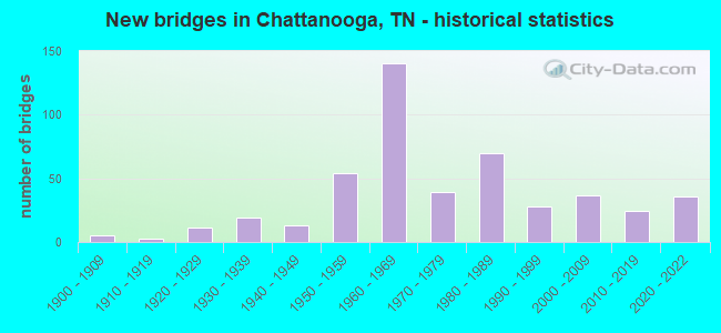
- New bridges - historical statistics
- 1Before 1900
- 51900-1909
- 31910-1919
- 111920-1929
- 191930-1939
- 131940-1949
- 541950-1959
- 1401960-1969
- 391970-1979
- 701980-1989
- 281990-1999
- 372000-2009
- 242010-2019
- 362020-2022

- Reconstructed bridges - Historical Statistics
- 31940-1949
- 01950-1959
- 01960-1969
- 71970-1979
- 161980-1989
- 311990-1999
- 12000-2009


- Bridge Condition - Deck
- 5.7%Very good
- 59.6%Good
- 25.7%Satisfactory
- 7.0%Fair
- 1.7%Poor
- 0.4%Serious

- Bridge Condition - Superstructure
- 11.7%Very good
- 34.8%Good
- 39.1%Satisfactory
- 10.9%Fair
- 2.6%Poor
- 0.9%Serious
- 0.4%Critical

- Bridge Condition - Substructure
- 3.9%Very good
- 58.3%Good
- 23.5%Satisfactory
- 10.0%Fair
- 4.3%Poor

- Bridge Condition - Channel
- 7.9%Very good
- 42.1%Good
- 38.6%Satisfactory
- 10.0%Fair
- 1.4%Poor

- Bridge Condition - Culverts
- 80.6%Good
- 15.3%Satisfactory
- 2.8%Fair
- 1.4%Serious
Find on map >> Show street view
Structure Number: 33004380005, Location: .01 MI EAST OF US 27 (Lat: 35.247800, Lng: -85.178817), Route carried "on" structure: City street 1126, Year Built: 1976, Status: Open, Structure Length: 0.93m (3.05ft), Average Daily Traffic: 10,479 (year 2020), Truck Traffic: 4%, Average Future Daily Traffic: 18,720 (year 2039), Design Load: HS 20, Features Intersected: POE BRANCH
Minimum Vertical Clearance: 30+ m (98+ ft), Kilometerpoint: 7.467, Lanes on structure: 2, Owner: City or Municipal Highway Agency, Approaching Roadway Width: 17.1m (56.1ft), Skew: 14 degrees, Material/Design: Concrete continuous, Design/Construction: Culvert, Number Of Spans In Main Unit: 2, Length of Maximum Span: 4.6m (15.1ft)
Condition: Channel: Satisfactory, Culverts: Good, Operating Rating: 87.3 metric tons, Method Used To Determine Operating Rating: Load Factor (LF), Inventory Rating: 32.4 metric tons, Method Used To Determine Inventory Rating: Load Factor (LF), Structural Evaluation: Better than present minimum criteria, Waterway Adequacy: Better than present minimum criteria, Approach Roadway Alignment: Equal to present desirable criteria, Designated Inspection Frequency: Every 24 months, Inspection Date: May 2021
Find on map >> Show street view
Structure Number: 33006030001, Location: SR-319 / TENN. RIVER (Lat: 35.097917, Lng: -85.251317), Route carried "on" structure: State highway 319, Year Built: 1976, Status: Open, Structure Length: 40.90m (134.19ft), Average Daily Traffic: 18,080 (year 2020), Truck Traffic: 13%, Average Future Daily Traffic: 28,928 (year 2042), Design Load: H 20, Features Intersected: TENNESSEE RIVER
Minimum Vertical Clearance: 30+ m (98+ ft), Kilometerpoint: 3.573, Lanes on structure: 6, Base Highway Network: Yes, Owner: State Highway Agency, Approaching Roadway Width: 31.7m (104.0ft), Skew: 20 degrees, Navigation Control: Yes ( Vertical Clearance: 23.0m (75.5ft), Horizontal Clearance: 138.6m (454.7ft)), Material/Design: Steel continuous, Design/Construction: Stringer/Multi-beam, Number Of Spans In Main Unit: 4, Length of Maximum Span: 146.3m (480.0ft), Curb-To-Curb Width: 33.5m (109.9ft), Out-to-Out Width: 34.1m (111.9ft)
Condition: Deck: Good, Superstructure: Satisfactory, Substructure: Fair, Channel: Satisfactory, Operating Rating: 52.2 metric tons, Method Used To Determine Operating Rating: Load Factor (LF), Inventory Rating: 31.5 metric tons, Method Used To Determine Inventory Rating: Load Factor (LF), Structural Evaluation: Somewhat better than minimum adequacy, Deck Geometry: Superior to present desirable criteria, Waterway Adequacy: Superior to present desirable criteria, Approach Roadway Alignment: Equal to present desirable criteria, Length Of Structure Improvement: 40.90m (134.19ft), Designated Inspection Frequency: Every 24 months, Critical Feature Inspection Frequency: Every 24 months, Underwater Inspection Frequency: Every 60 months, Inspection Date: April 2021, Critical Feature Inspection Date: April 2021, Underwater Inspection Date: September 2021, Bridge Improvement Cost: $51,767,000, Roadway Improvement Cost: $5,177,000, Total Project Cost: $77,651,000 ( Estimate for 2022), Deck Structure Type: Concrete Cast-file-Place, Wearing Surface/Protective System: Wearing Surface: Low Slump Concrete
Find on map >> Show street view
Structure Number: 33006030003, Location: 0.12 MI. S OF TENN. RIVER (Lat: 35.096600, Lng: -85.250317), Route carried "on" structure: State highway 319, Year Built: 1981, Status: Open, Structure Length: 7.83m (25.69ft), Average Daily Traffic: 18,080 (year 2020), Truck Traffic: 13%, Average Future Daily Traffic: 28,928 (year 2042), Features Intersected: SOUTHERN RAILWAY
Minimum Vertical Clearance: 30+ m (98+ ft), Kilometerpoint: 3.380, Lanes on structure: 7, Base Highway Network: Yes, Owner: State Highway Agency, Approaching Roadway Width: 29.3m (96.1ft), Skew: 1 degrees, Material/Design: Prestressed concrete continuous, Design/Construction: Stringer/Multi-beam, Number Of Spans In Main Unit: 4, Length of Maximum Span: 20.7m (67.9ft), Curb-To-Curb Width: 35.7m (117.1ft), Out-to-Out Width: 36.3m (119.1ft)
Condition: Deck: Good, Superstructure: Good, Substructure: Satisfactory, Operating Rating: 54.0 metric tons, Method Used To Determine Operating Rating: Load Factor (LF), Inventory Rating: 32.4 metric tons, Method Used To Determine Inventory Rating: Load Factor (LF), Structural Evaluation: Equal to present minimum criteria, Deck Geometry: Superior to present desirable criteria, Underclear: Equal to present minimum criteria, Approach Roadway Alignment: Better than present minimum criteria, Designated Inspection Frequency: Every 24 months, Inspection Date: April 2021, Deck Structure Type: Concrete Precast Panels, Wearing Surface/Protective System: Wearing Surface: Monolithic Concrete
Find on map >> Show street view
Structure Number: 33006030015, Location: .5 MI. N. OF TN. RV. (Lat: 35.103800, Lng: -85.254733), Route carried "on" structure: State highway 319, Year Built: 1978, Status: Open, Structure Length: 5.76m (18.90ft), Average Daily Traffic: 18,080 (year 2020), Truck Traffic: 13%, Average Future Daily Traffic: 28,928 (year 2042), Design Load: H 20, Features Intersected: SOUTHERN RAILWAY
Minimum Vertical Clearance: 30+ m (98+ ft), Kilometerpoint: 4.297, Lanes on structure: 6, Base Highway Network: Yes, Owner: State Highway Agency, Approaching Roadway Width: 32.9m (107.9ft), Skew: 31 degrees, Material/Design: Prestressed concrete continuous, Design/Construction: Stringer/Multi-beam, Number Of Spans In Main Unit: 3, Length of Maximum Span: 19.2m (63.0ft), Curb-To-Curb Width: 33.5m (109.9ft), Out-to-Out Width: 34.1m (111.9ft)
Condition: Deck: Good, Superstructure: Satisfactory, Substructure: Good, Operating Rating: 57.6 metric tons, Method Used To Determine Operating Rating: Load Factor (LF), Inventory Rating: 32.4 metric tons, Method Used To Determine Inventory Rating: Load Factor (LF), Structural Evaluation: Equal to present minimum criteria, Deck Geometry: Superior to present desirable criteria, Underclear: Superior to present desirable criteria, Approach Roadway Alignment: Equal to present desirable criteria, Designated Inspection Frequency: Every 24 months, Inspection Date: April 2021, Deck Structure Type: Concrete Precast Panels, Wearing Surface/Protective System: Wearing Surface: Bituminous
Find on map >> Show street view
Structure Number: 33006030017, Location: 1.0 MI. N. OF TN. RV. (Lat: 35.111717, Lng: -85.250933), Route carried "on" structure: State highway 319, Year Built: 1978, Status: Open, Structure Length: 5.94m (19.49ft), Average Daily Traffic: 12,649 (year 2020), Truck Traffic: 13%, Average Future Daily Traffic: 20,238 (year 2042), Design Load: HS 20, Features Intersected: FAU 3542
Minimum Vertical Clearance: 30+ m (98+ ft), Kilometerpoint: 5.246, Lanes on structure: 4, Lanes under structure: 6, Base Highway Network: Yes, Owner: State Highway Agency, Approaching Roadway Width: 50.9m (167.0ft), Skew: 20 degrees, Material/Design: Steel, Design/Construction: Box Beam or Girders - Single/Spread, Number Of Spans In Main Unit: 1, Length of Maximum Span: 46.9m (153.9ft), Curb-To-Curb Width: 50.9m (167.0ft), Out-to-Out Width: 51.5m (169.0ft)
Condition: Deck: Satisfactory, Superstructure: Satisfactory, Substructure: Satisfactory, Operating Rating: 49.2 metric tons, Method Used To Determine Operating Rating: Load and Resistance Factor Rating (LRFR) rating reported by rating factor(RF) method using HL-93 loadings, Inventory Rating: 37.9 metric tons, Method Used To Determine Inventory Rating: Load and Resistance Factor Rating (LRFR) rating reported by rating factor(RF) method using HL-93 loadings, Structural Evaluation: Equal to present minimum criteria, Deck Geometry: Superior to present desirable criteria, Underclear: Superior to present desirable criteria, Approach Roadway Alignment: Equal to present desirable criteria, Designated Inspection Frequency: Every 24 months, Inspection Date: April 2021, Deck Structure Type: Concrete Cast-file-Place, Wearing Surface/Protective System: Wearing Surface: Monolithic Concrete
Find on map >> Show street view
Structure Number: 33006030019, Location: 1.4 MI. N. TENN. RIVER (Lat: 35.116783, Lng: -85.248483), Route carried "on" structure: State highway 319, Year Built: 1981, Status: Open, Structure Length: 5.27m (17.29ft), Average Daily Traffic: 27,557 (year 2020), Truck Traffic: 13%, Average Future Daily Traffic: 44,091 (year 2042), Design Load: HS 20, Features Intersected: FAU 3588 & E697
Minimum Vertical Clearance: 30+ m (98+ ft), Kilometerpoint: 5.842, Lanes on structure: 4, Lanes under structure: 4, Base Highway Network: Yes, Owner: State Highway Agency, Approaching Roadway Width: 26.2m (86.0ft), Skew: 20 degrees, Material/Design: Prestressed concrete continuous, Design/Construction: Box Beam or Girders - Single/Spread, Number Of Spans In Main Unit: 2, Length of Maximum Span: 30.8m (101.0ft), Curb-To-Curb Width: 26.2m (86.0ft), Out-to-Out Width: 26.8m (87.9ft)
Condition: Deck: Good, Superstructure: Satisfactory, Substructure: Good, Operating Rating: 68.4 metric tons, Method Used To Determine Operating Rating: Load Factor (LF), Inventory Rating: 32.4 metric tons, Method Used To Determine Inventory Rating: Load Factor (LF), Structural Evaluation: Equal to present minimum criteria, Deck Geometry: Superior to present desirable criteria, Underclear: Meets minimum limits, Approach Roadway Alignment: Equal to present minimum criteria, Designated Inspection Frequency: Every 24 months, Inspection Date: April 2021, Deck Structure Type: Concrete Precast Panels, Wearing Surface/Protective System: Wearing Surface: Monolithic Concrete, Deck Protection: Epoxy Coated Reinforcing
Find on map >> Show street view
Structure Number: 33006030021, Location: 0.24 MI. W OF SR-153 JCT. (Lat: 35.119267, Lng: -85.240983), Route carried "on" structure: State highway 319, Year Built: 1981, Status: Open, Structure Length: 0.67m (2.20ft), Average Daily Traffic: 27,557 (year 2020), Truck Traffic: 9%, Average Future Daily Traffic: 44,091 (year 2042), Design Load: HS 20, Features Intersected: BRANCH
Minimum Vertical Clearance: 30+ m (98+ ft), Kilometerpoint: 6.614, Lanes on structure: 4, Base Highway Network: Yes, Owner: State Highway Agency, Approaching Roadway Width: 39.6m (129.9ft), Skew: 20 degrees, Material/Design: Concrete continuous, Design/Construction: Culvert, Number Of Spans In Main Unit: 2, Length of Maximum Span: 3.0m (9.8ft)
Condition: Channel: Fair, Culverts: Good, Operating Rating: 89.1 metric tons, Method Used To Determine Operating Rating: Load Factor (LF), Inventory Rating: 32.4 metric tons, Method Used To Determine Inventory Rating: Load Factor (LF), Structural Evaluation: Better than present minimum criteria, Waterway Adequacy: Equal to present desirable criteria, Approach Roadway Alignment: Equal to present desirable criteria, Length Of Structure Improvement: 0.67m (2.20ft), Designated Inspection Frequency: Every 24 months, Inspection Date: April 2021, Bridge Improvement Cost: $236,000, Roadway Improvement Cost: $24,000, Total Project Cost: $355,000 ( Estimate for 2022)
Find on map >> Show street view
Structure Number: 33011450001, Location: .01 MI WEST OF I75 (Lat: 35.105700, Lng: -85.052233), Route carried "on" structure: City street 4975, Year Built: 1981, Status: Open, Structure Length: 0.78m (2.56ft), Average Daily Traffic: 11,533 (year 2020), Truck Traffic: 4%, Average Future Daily Traffic: 7,472 (year 2040), Design Load: HS 20, Features Intersected: SMALL BRANCH
Minimum Vertical Clearance: 30+ m (98+ ft), Kilometerpoint: 2.366, Lanes on structure: 2, Owner: City or Municipal Highway Agency, Approaching Roadway Width: 14.0m (45.9ft), Skew: 1 degrees, Material/Design: Concrete continuous, Design/Construction: Culvert, Number Of Spans In Main Unit: 2, Length of Maximum Span: 3.0m (9.8ft)
Condition: Channel: Fair, Culverts: Good, Operating Rating: 76.5 metric tons, Method Used To Determine Operating Rating: Load Factor (LF), Inventory Rating: 32.4 metric tons, Method Used To Determine Inventory Rating: Load Factor (LF), Structural Evaluation: Better than present minimum criteria, Waterway Adequacy: Better than present minimum criteria, Approach Roadway Alignment: Equal to present desirable criteria, Designated Inspection Frequency: Every 24 months, Inspection Date: Febuary 2022
Find on map >> Show street view
Structure Number: 33021990001, Location: 1 MI EAST OF I24 (Lat: 35.005250, Lng: -85.378133), Route carried "on" structure: City street 2199, Year Built: 1965, Year Reconstructed: 1990, Status: Open, Structure Length: 0.64m (2.10ft), Average Daily Traffic: 2,897 (year 2020), Truck Traffic: 4%, Average Future Daily Traffic: 4,288 (year 2040), Design Load: HS 20, Features Intersected: BLACK CREEK
Minimum Vertical Clearance: 30+ m (98+ ft), Kilometerpoint: 2.478, Lanes on structure: 2, Owner: City or Municipal Highway Agency, Approaching Roadway Width: 14.6m (47.9ft), Material/Design: Concrete continuous, Design/Construction: Culvert, Number Of Spans In Main Unit: 2, Length of Maximum Span: 3.0m (9.8ft), Curb-To-Curb Width: 13.9m (45.6ft), Out-to-Out Width: 18.0m (59.1ft)
Condition: Channel: Satisfactory, Culverts: Good, Operating Rating: 68.4 metric tons, Method Used To Determine Operating Rating: Load Factor (LF), Inventory Rating: 32.4 metric tons, Method Used To Determine Inventory Rating: Load Factor (LF), Structural Evaluation: Better than present minimum criteria, Deck Geometry: Superior to present desirable criteria, Waterway Adequacy: Better than present minimum criteria, Approach Roadway Alignment: Equal to present desirable criteria, Designated Inspection Frequency: Every 24 months, Inspection Date: March 2020, Deck Structure Type: Concrete Cast-file-Place, Wearing Surface/Protective System: Wearing Surface: Bituminous
Find on map >> Show street view
Structure Number: 33022050001, Location: 2 MI NW OF I75 (Lat: 35.119717, Lng: -85.083900), Route carried "on" structure: County highway 2205, Year Built: 1965, Status: Open, Structure Length: 0.76m (2.49ft), Average Daily Traffic: 3,293 (year 2020), Truck Traffic: 4%, Average Future Daily Traffic: 5,056 (year 2040), Design Load: HS 20, Features Intersected: BRANCH
Minimum Vertical Clearance: 30+ m (98+ ft), Kilometerpoint: 4.844, Lanes on structure: 2, Owner: County Highway Agency, Approaching Roadway Width: 6.7m (22.0ft), Skew: 4 degrees, Material/Design: Concrete continuous, Design/Construction: Culvert, Number Of Spans In Main Unit: 2, Length of Maximum Span: 2.4m (7.9ft), Curb-To-Curb Width: 9.0m (29.5ft), Out-to-Out Width: 14.5m (47.6ft)
Condition: Channel: Satisfactory, Culverts: Satisfactory, Operating Rating: 60.3 metric tons, Method Used To Determine Operating Rating: Load Factor (LF), Inventory Rating: 32.4 metric tons, Method Used To Determine Inventory Rating: Load Factor (LF), Structural Evaluation: Equal to present minimum criteria, Deck Geometry: Meets minimum limits, Waterway Adequacy: Better than present minimum criteria, Approach Roadway Alignment: Better than present minimum criteria, Length Of Structure Improvement: 0.76m (2.49ft), Designated Inspection Frequency: Every 24 months, Inspection Date: Febuary 2022, Bridge Improvement Cost: $1,000, Roadway Improvement Cost: $1,000, Total Project Cost: $2,000 ( Estimate for 2020), Deck Structure Type: Concrete Cast-file-Place, Wearing Surface/Protective System: Wearing Surface: Bituminous
Find on map >> Show street view
Structure Number: 33022050003, Location: .01 MI NORTH OF I75 (Lat: 35.084717, Lng: -85.073517), Route carried "on" structure: County highway 2205, Year Built: 2009, Status: Open, Structure Length: 12.19m (39.99ft), Average Daily Traffic: 3,293 (year 2020), Truck Traffic: 4%, Average Future Daily Traffic: 5,056 (year 2040), Design Load: HL 93, Features Intersected: WOLFTEVER CREEK
Minimum Vertical Clearance: 30+ m (98+ ft), Kilometerpoint: 9.479, Lanes on structure: 3, Owner: County Highway Agency, Approaching Roadway Width: 17.1m (56.1ft), Material/Design: Prestressed concrete continuous, Design/Construction: Stringer/Multi-beam, Number Of Spans In Main Unit: 4, Length of Maximum Span: 30.5m (100.1ft), Curb-To-Curb Width: 20.7m (67.9ft), Out-to-Out Width: 21.3m (69.9ft)
Condition: Deck: Good, Superstructure: Good, Substructure: Good, Channel: Satisfactory, Operating Rating: 32.4 metric tons, Method Used To Determine Operating Rating: Load and Resistance Factor Rating (LRFR) rating reported by rating factor(RF) method using HL-93 loadings, Inventory Rating: 24.6 metric tons, Method Used To Determine Inventory Rating: Load and Resistance Factor Rating (LRFR) rating reported by rating factor(RF) method using HL-93 loadings, Structural Evaluation: Equal to present minimum criteria, Deck Geometry: Superior to present desirable criteria, Waterway Adequacy: Superior to present desirable criteria, Approach Roadway Alignment: Equal to present desirable criteria, Designated Inspection Frequency: Every 24 months, Inspection Date: Febuary 2022, Deck Structure Type: Concrete Cast-file-Place, Wearing Surface/Protective System: Wearing Surface: Monolithic Concrete, Deck Protection: Epoxy Coated Reinforcing
Find on map >> Show street view
Structure Number: 33022070001, Location: 1 MI NW OF I75 (Lat: 35.140483, Lng: -85.065933), Route carried "on" structure: County highway 2207, Year Built: 1987, Status: Open, Structure Length: 1.25m (4.10ft), Average Daily Traffic: 3,169 (year 2020), Truck Traffic: 3%, Average Future Daily Traffic: 4,752 (year 2040), Design Load: HS 20, Features Intersected: ROGERS BRANCH
Minimum Vertical Clearance: 30+ m (98+ ft), Kilometerpoint: 6.598, Lanes on structure: 2, Owner: County Highway Agency, Approaching Roadway Width: 7.6m (24.9ft), Skew: 1 degrees, Material/Design: Concrete continuous, Design/Construction: Culvert, Number Of Spans In Main Unit: 3, Length of Maximum Span: 3.7m (12.1ft), Curb-To-Curb Width: 9.2m (30.2ft), Out-to-Out Width: 10.3m (33.8ft)
Condition: Channel: Good, Culverts: Good, Operating Rating: 45.0 metric tons, Method Used To Determine Operating Rating: Load Factor (LF), Inventory Rating: 28.8 metric tons, Method Used To Determine Inventory Rating: Load Factor (LF), Structural Evaluation: Better than present minimum criteria, Deck Geometry: Meets minimum limits, Waterway Adequacy: Better than present minimum criteria, Approach Roadway Alignment: Equal to present desirable criteria, Length Of Structure Improvement: 1.25m (4.10ft), Designated Inspection Frequency: Every 24 months, Inspection Date: Febuary 2022, Bridge Improvement Cost: $97,000, Roadway Improvement Cost: $10,000, Total Project Cost: $146,000 ( Estimate for 2020), Deck Structure Type: Concrete Cast-file-Place, Wearing Surface/Protective System: Wearing Surface: Monolithic Concrete
Find on map >> Show street view
Structure Number: 33022070003, Location: 2 MI EAST OF SR 58 (Lat: 35.157233, Lng: -85.060883), Route carried "on" structure: County highway 2207, Year Built: 1940, Year Reconstructed: 1985, Status: Open, Structure Length: 4.27m (14.01ft), Average Daily Traffic: 3,169 (year 2020), Truck Traffic: 3%, Average Future Daily Traffic: 5,070 (year 2041), Design Load: HS 20, Features Intersected: LONG SAVANNAH CREEK
Minimum Vertical Clearance: 30+ m (98+ ft), Kilometerpoint: 8.707, Lanes on structure: 2, Owner: County Highway Agency, Approaching Roadway Width: 8.5m (27.9ft), Material/Design: Prestressed concrete continuous, Design/Construction: Stringer/Multi-beam, Number Of Spans In Main Unit: 3, Length of Maximum Span: 18.0m (59.1ft), Curb-To-Curb Width: 7.9m (25.9ft), Out-to-Out Width: 8.6m (28.2ft)
Condition: Deck: Good, Superstructure: Good, Substructure: Good, Channel: Good, Operating Rating: 65.7 metric tons, Method Used To Determine Operating Rating: Load Factor (LF), Inventory Rating: 32.4 metric tons, Method Used To Determine Inventory Rating: Load Factor (LF), Structural Evaluation: Better than present minimum criteria, Deck Geometry: High priority of corrective action, Waterway Adequacy: Superior to present desirable criteria, Approach Roadway Alignment: Equal to present desirable criteria, Length Of Structure Improvement: 4.27m (14.01ft), Designated Inspection Frequency: Every 24 months, Underwater Inspection Frequency: Every 60 months, Inspection Date: Febuary 2022, Underwater Inspection Date: June 2021, Bridge Improvement Cost: $864,000, Roadway Improvement Cost: $87,000, Total Project Cost: $1,297,000 ( Estimate for 2021), Deck Structure Type: Concrete Precast Panels, Wearing Surface/Protective System: Wearing Surface: Monolithic Concrete, Deck Protection: Epoxy Coated Reinforcing
Find on map >> Show street view
Structure Number: 33035460001, Location: 0VER TN RV IN CHATTANOOGA (Lat: 35.053967, Lng: -85.303550), Route carried "on" structure: City street 3546, Year Built: 1984, Status: Open, Structure Length: 79.80m (261.81ft), Average Daily Traffic: 13,400 (year 2020), Truck Traffic: 4%, Average Future Daily Traffic: 21,440 (year 2041), Design Load: HS 20, Features Intersected: TN RIVER & A231 & A267
Minimum Vertical Clearance: 30+ m (98+ ft), Kilometerpoint: 0.692, Lanes on structure: 4, Lanes under structure: 4, Base Highway Network: Yes, Owner: City or Municipal Highway Agency, Approaching Roadway Width: 23.2m (76.1ft), Skew: 20 degrees, Navigation Control: Yes ( Vertical Clearance: 14.6m (47.9ft), Horizontal Clearance: 121.9m (399.9ft)), Material/Design: Steel continuous, Design/Construction: Stringer/Multi-beam, Number Of Spans In Main Unit: 5, Number Of Approach Spans: 8, Length of Maximum Span: 128.0m (419.9ft), Curb or Sidewalk Widths: Left: 0.0m, Right: 1.5m (4.9ft), Curb-To-Curb Width: 27.7m (90.9ft), Out-to-Out Width: 28.3m (92.8ft)
Condition: Deck: Satisfactory, Superstructure: Satisfactory, Substructure: Fair, Channel: Very good, Operating Rating: 44.1 metric tons, Method Used To Determine Operating Rating: Assigned rating based on Load Factor Design (LFD) reported in metric tons, Inventory Rating: 32.4 metric tons, Method Used To Determine Inventory Rating: Assigned rating based on Load Factor Design (LFD) reported in metric tons, Structural Evaluation: Somewhat better than minimum adequacy, Deck Geometry: Superior to present desirable criteria, Underclear: High priority of corrective action, Waterway Adequacy: Superior to present desirable criteria, Approach Roadway Alignment: Equal to present desirable criteria, Designated Inspection Frequency: Every 24 months, Underwater Inspection Frequency: Every 60 months, Inspection Date: Febuary 2021, Underwater Inspection Date: August 2017, Deck Structure Type: Concrete Precast Panels, Wearing Surface/Protective System: Wearing Surface: Monolithic Concrete, Deck Protection: Epoxy Coated Reinforcing
Find on map >> Show street view
Structure Number: 33035490001, Location: CNTL BUSINESS DIST-CHATT. (Lat: 35.053100, Lng: -85.303867), Route carried "on" structure: City street 3549, Year Built: 1971, Status: Open, Structure Length: 4.51m (14.80ft), Average Daily Traffic: 2,241 (year 2020), Truck Traffic: 9%, Average Future Daily Traffic: 3,586 (year 2042), Design Load: Pedestrian, Features Intersected: FAU 3546(GEORGIA AVE)
Minimum Vertical Clearance: 30+ m (98+ ft), Kilometerpoint: 0.805, Lanes on structure: 3, Lanes under structure: 4, Base Highway Network: Yes, Owner: City or Municipal Highway Agency, Approaching Roadway Width: 11.0m (36.1ft), Material/Design: Prestressed concrete continuous, Design/Construction: Box Beam or Girders - Single/Spread, Number Of Spans In Main Unit: 3, Length of Maximum Span: 20.1m (65.9ft), Curb or Sidewalk Widths: Left: 2.4m (7.9ft), Right: 2.4m (7.9ft), Curb-To-Curb Width: 12.2m (40.0ft), Out-to-Out Width: 17.1m (56.1ft)
Condition: Deck: Good, Superstructure: Satisfactory, Substructure: Good, Operating Rating: 68.4 metric tons, Method Used To Determine Operating Rating: Load Factor (LF), Inventory Rating: 32.4 metric tons, Method Used To Determine Inventory Rating: Load Factor (LF), Structural Evaluation: Equal to present minimum criteria, Deck Geometry: Meets minimum limits, Underclear: High priority of corrective action, Approach Roadway Alignment: Equal to present desirable criteria, Length Of Structure Improvement: 4.51m (14.80ft), Designated Inspection Frequency: Every 24 months, Inspection Date: May 2021, Bridge Improvement Cost: $372,000, Roadway Improvement Cost: $38,000, Total Project Cost: $559,000 ( Estimate for 2022), Deck Structure Type: Concrete Cast-file-Place, Wearing Surface/Protective System: Wearing Surface: Bituminous
Find on map >> Show street view
Structure Number: 33035520001, Location: .5 MI. W. 3RD AVE & RR YD (Lat: 35.048950, Lng: -85.293683), Route carried "on" structure: City street 3552, Year Built: 1952, Status: Open, Structure Length: 0.79m (2.59ft), Average Daily Traffic: 13,646 (year 2020), Truck Traffic: 4%, Average Future Daily Traffic: 21,834 (year 2042), Design Load: HS 20, Features Intersected: ABANDONED SPUR LINE
Minimum Vertical Clearance: 30+ m (98+ ft), Kilometerpoint: 1.561, Lanes on structure: 4, Owner: City or Municipal Highway Agency, Approaching Roadway Width: 16.5m (54.1ft), Skew: 12 degrees, Material/Design: Concrete, Design/Construction: Tee Beam, Number Of Spans In Main Unit: 1, Length of Maximum Span: 7.9m (25.9ft), Curb or Sidewalk Widths: Left: 2.4m (7.9ft), Right: 2.4m (7.9ft), Curb-To-Curb Width: 16.6m (54.5ft), Out-to-Out Width: 22.4m (73.5ft)
Condition: Deck: Good, Superstructure: Good, Substructure: Good, Operating Rating: 89.1 metric tons, Method Used To Determine Operating Rating: Load Factor (LF), Inventory Rating: 32.4 metric tons, Method Used To Determine Inventory Rating: Load Factor (LF), Structural Evaluation: Better than present minimum criteria, Deck Geometry: Somewhat better than minimum adequacy, Approach Roadway Alignment: Equal to present desirable criteria, Length Of Structure Improvement: 0.79m (2.59ft), Designated Inspection Frequency: Every 24 months, Inspection Date: May 2021, Bridge Improvement Cost: $323,000, Roadway Improvement Cost: $33,000, Total Project Cost: $485,000 ( Estimate for 2022), Deck Structure Type: Concrete Cast-file-Place, Wearing Surface/Protective System: Wearing Surface: Bituminous
Find on map >> Show street view
Structure Number: 33035520003, Location: THIRD ST / CITCO YARDS (Lat: 35.045533, Lng: -85.284467), Route carried "on" structure: City street 3552, Year Built: 2003, Status: Open, Structure Length: 26.12m (85.70ft), Average Daily Traffic: 10,482 (year 2020), Truck Traffic: 4%, Average Future Daily Traffic: 27,424 (year 2039), Design Load: HS 20, Features Intersected: CITICO YDS & NFA F466
Minimum Vertical Clearance: 30+ m (98+ ft), Kilometerpoint: 2.478, Lanes on structure: 4, Lanes under structure: 1, Owner: City or Municipal Highway Agency, Approaching Roadway Width: 19.2m (63.0ft), Skew: 1 degrees, Material/Design: Steel continuous, Design/Construction: Stringer/Multi-beam, Number Of Spans In Main Unit: 6, Length of Maximum Span: 50.7m (166.3ft), Curb or Sidewalk Widths: Left: 1.5m (4.9ft), Right: 1.5m (4.9ft), Curb-To-Curb Width: 19.2m (63.0ft), Out-to-Out Width: 22.8m (74.8ft)
Condition: Deck: Good, Superstructure: Good, Substructure: Good, Operating Rating: 44.1 metric tons, Method Used To Determine Operating Rating: Assigned rating based on Load Factor Design (LFD) reported in metric tons, Inventory Rating: 32.4 metric tons, Method Used To Determine Inventory Rating: Assigned rating based on Load Factor Design (LFD) reported in metric tons, Structural Evaluation: Better than present minimum criteria, Deck Geometry: Equal to present minimum criteria, Underclear: High priority of corrective action, Approach Roadway Alignment: Equal to present desirable criteria, Designated Inspection Frequency: Every 24 months, Inspection Date: May 2021, Deck Structure Type: Concrete Cast-file-Place, Wearing Surface/Protective System: Wearing Surface: Monolithic Concrete, Deck Protection: Epoxy Coated Reinforcing
Find on map >> Show street view
Structure Number: 33035560003, Location: WILCOX BLVD / RR YARDS (Lat: 35.057350, Lng: -85.273617), Route carried "on" structure: City street 3556, Year Built: 1958, Status: Posted for load, Structure Length: 24.99m (81.99ft), Average Daily Traffic: 13,060 (year 2020), Truck Traffic: 9%, Average Future Daily Traffic: 27,856 (year 2041), Design Load: H 20, Features Intersected: CSX & NS RAILROAD
Minimum Vertical Clearance: 30+ m (98+ ft), Kilometerpoint: 0.241, Lanes on structure: 2, Base Highway Network: Yes, Owner: City or Municipal Highway Agency, Approaching Roadway Width: 9.4m (30.8ft), Skew: 10 degrees, Material/Design: Steel, Design/Construction: Stringer/Multi-beam, Number Of Spans In Main Unit: 17, Length of Maximum Span: 23.8m (78.1ft), Curb or Sidewalk Widths: Left: 0.0m, Right: 1.9m (6.2ft), Curb-To-Curb Width: 7.3m (24.0ft), Out-to-Out Width: 9.5m (31.2ft)
Condition: Deck: Poor, Superstructure: Poor, Substructure: Poor, Operating Rating: 34.2 metric tons, Method Used To Determine Operating Rating: Load Factor (LF), Inventory Rating: 20.7 metric tons, Method Used To Determine Inventory Rating: Load Factor (LF), Structural Evaluation: Meets minimum limits, Deck Geometry: High priority of replacement, Underclear: Meets minimum limits, Approach Roadway Alignment: Equal to present desirable criteria, Bridge Posting: Required (Relationship of Operating Rating to Maximum Legal Load: 0.1 - 9.9% below), Length Of Structure Improvement: 24.99m (81.99ft), Designated Inspection Frequency: Every 24 months, Inspection Date: March 2021, Bridge Improvement Cost: $7,715,000, Roadway Improvement Cost: $772,000, Total Project Cost: $11,573,000 ( Estimate for 2021), Deck Structure Type: Concrete Cast-file-Place, Wearing Surface/Protective System: Wearing Surface: Monolithic Concrete
Find on map >> Show street view
Structure Number: 33035560004, Location: WILCOX BLVD / RR YARDS (Lat: 35.057200, Lng: -85.273433), Route carried "on" structure: City street 3556, Year Built: 1954, Status: Posted for load, Structure Length: 24.93m (81.79ft), Average Daily Traffic: 13,060 (year 2020), Truck Traffic: 9%, Average Future Daily Traffic: 27,856 (year 2041), Design Load: H 20, Features Intersected: CSX & NS RAILROAD
Minimum Vertical Clearance: 30+ m (98+ ft), Kilometerpoint: 0.241, Lanes on structure: 2, Base Highway Network: Yes, Owner: City or Municipal Highway Agency, Approaching Roadway Width: 7.3m (24.0ft), Skew: 20 degrees, Material/Design: Steel, Design/Construction: Stringer/Multi-beam, Number Of Spans In Main Unit: 17, Length of Maximum Span: 22.6m (74.1ft), Curb-To-Curb Width: 7.3m (24.0ft), Out-to-Out Width: 8.2m (26.9ft)
Condition: Deck: Poor, Superstructure: Poor, Substructure: Poor, Operating Rating: 34.2 metric tons, Method Used To Determine Operating Rating: Load Factor (LF), Inventory Rating: 20.7 metric tons, Method Used To Determine Inventory Rating: Load Factor (LF), Structural Evaluation: Meets minimum limits, Deck Geometry: High priority of replacement, Underclear: Meets minimum limits, Approach Roadway Alignment: Equal to present desirable criteria, Bridge Posting: Required (Relationship of Operating Rating to Maximum Legal Load: 0.1 - 9.9% below), Length Of Structure Improvement: 24.93m (81.79ft), Designated Inspection Frequency: Every 24 months, Inspection Date: March 2021, Bridge Improvement Cost: $6,740,000, Roadway Improvement Cost: $675,000, Total Project Cost: $10,111,000 ( Estimate for 2021), Deck Structure Type: Concrete Cast-file-Place, Wearing Surface/Protective System: Wearing Surface: Monolithic Concrete
Find on map >> Show street view
Structure Number: 33035560007, Location: 2 MI SW OF SR 153 (Lat: 35.048583, Lng: -85.214300), Route carried "on" structure: City street 3556, Year Built: 2012, Status: Open, Structure Length: 15.24m (50.00ft), Average Daily Traffic: 16,516 (year 2020), Truck Traffic: 9%, Average Future Daily Traffic: 30,992 (year 2039), Design Load: HL 93, Features Intersected: CHICKAMAUGA CREEK
Minimum Vertical Clearance: 30+ m (98+ ft), Kilometerpoint: 6.405, Lanes on structure: 5, Base Highway Network: Yes, Owner: City or Municipal Highway Agency, Approaching Roadway Width: 19.5m (64.0ft), Material/Design: Prestressed concrete continuous, Design/Construction: Stringer/Multi-beam, Number Of Spans In Main Unit: 4, Length of Maximum Span: 38.1m (125.0ft), Curb or Sidewalk Widths: Left: 1.5m (4.9ft), Right: 2.4m (7.9ft), Curb-To-Curb Width: 19.5m (64.0ft), Out-to-Out Width: 24.1m (79.1ft)
Condition: Deck: Good, Superstructure: Good, Substructure: Good, Channel: Good, Operating Rating: 44.1 metric tons, Method Used To Determine Operating Rating: Load and Resistance Factor Rating (LRFR) rating reported by rating factor(RF) method using HL-93 loadings, Inventory Rating: 32.4 metric tons, Method Used To Determine Inventory Rating: Load and Resistance Factor Rating (LRFR) rating reported by rating factor(RF) method using HL-93 loadings, Structural Evaluation: Better than present minimum criteria, Deck Geometry: Meets minimum limits, Waterway Adequacy: Equal to present desirable criteria, Approach Roadway Alignment: Equal to present desirable criteria, Designated Inspection Frequency: Every 24 months, Inspection Date: June 2021, Deck Structure Type: Concrete Cast-file-Place, Wearing Surface/Protective System: Wearing Surface: Monolithic Concrete, Deck Protection: Epoxy Coated Reinforcing
Find on map >> Show street view
Structure Number: 33035560009, Location: IN CHATTANOOGA (Lat: 35.055950, Lng: -85.205817), Route carried "on" structure: City street 3556, Year Built: 1959, Status: Open, Structure Length: 3.93m (12.89ft), Average Daily Traffic: 15,246 (year 2020), Truck Traffic: 9%, Average Future Daily Traffic: 30,192 (year 2039), Design Load: H 20, Features Intersected: ABANDONED SPUR LINE
Minimum Vertical Clearance: 30+ m (98+ ft), Kilometerpoint: 7.612, Lanes on structure: 2, Base Highway Network: Yes, Owner: City or Municipal Highway Agency, Approaching Roadway Width: 10.4m (34.1ft), Skew: 3 degrees, Material/Design: Concrete, Design/Construction: Tee Beam, Number Of Spans In Main Unit: 3, Length of Maximum Span: 13.1m (43.0ft), Curb-To-Curb Width: 8.5m (27.9ft), Out-to-Out Width: 10.5m (34.4ft)
Condition: Deck: Satisfactory, Superstructure: Satisfactory, Substructure: Fair, Operating Rating: 65.7 metric tons, Method Used To Determine Operating Rating: Load Factor (LF), Inventory Rating: 32.4 metric tons, Method Used To Determine Inventory Rating: Load Factor (LF), Structural Evaluation: Somewhat better than minimum adequacy, Deck Geometry: High priority of replacement, Approach Roadway Alignment: Equal to present desirable criteria, Length Of Structure Improvement: 3.93m (12.89ft), Designated Inspection Frequency: Every 24 months, Inspection Date: June 2021, Bridge Improvement Cost: $343,000, Roadway Improvement Cost: $35,000, Total Project Cost: $515,000 ( Estimate for 2019), Deck Structure Type: Concrete Cast-file-Place, Wearing Surface/Protective System: Wearing Surface: Bituminous
Find on map >> Show street view
Structure Number: 33035560011, Location: IN CHATTANOOGA (Lat: 35.055700, Lng: -85.203617), Route carried "on" structure: City street 3556, Year Built: 1959, Status: Open, Structure Length: 4.39m (14.40ft), Average Daily Traffic: 15,246 (year 2020), Truck Traffic: 9%, Average Future Daily Traffic: 30,192 (year 2039), Design Load: HS 20, Features Intersected: CSX RAILROAD
Minimum Vertical Clearance: 30+ m (98+ ft), Kilometerpoint: 7.821, Lanes on structure: 2, Base Highway Network: Yes, Owner: City or Municipal Highway Agency, Approaching Roadway Width: 10.4m (34.1ft), Skew: 3 degrees, Material/Design: Concrete, Design/Construction: Tee Beam, Number Of Spans In Main Unit: 3, Length of Maximum Span: 14.6m (47.9ft), Curb-To-Curb Width: 8.5m (27.9ft), Out-to-Out Width: 10.5m (34.4ft)
Condition: Deck: Satisfactory, Superstructure: Satisfactory, Substructure: Fair, Operating Rating: 69.3 metric tons, Method Used To Determine Operating Rating: Load Factor (LF), Inventory Rating: 32.4 metric tons, Method Used To Determine Inventory Rating: Load Factor (LF), Structural Evaluation: Somewhat better than minimum adequacy, Deck Geometry: High priority of replacement, Underclear: Equal to present minimum criteria, Approach Roadway Alignment: Equal to present desirable criteria, Length Of Structure Improvement: 4.39m (14.40ft), Designated Inspection Frequency: Every 24 months, Inspection Date: June 2021, Bridge Improvement Cost: $382,000, Roadway Improvement Cost: $39,000, Total Project Cost: $574,000 ( Estimate for 2019), Deck Structure Type: Concrete Cast-file-Place, Wearing Surface/Protective System: Wearing Surface: Bituminous
Find on map >> Show street view
Structure Number: 33035730001, Location: INTERSECTION 23RDST&4THAV (Lat: 35.018483, Lng: -85.279017), Route carried "on" structure: City street 3573, Year Built: 1970, Status: Open, Structure Length: 0.69m (2.26ft), Average Daily Traffic: 4,065 (year 2020), Truck Traffic: 4%, Average Future Daily Traffic: 8,000 (year 2039), Features Intersected: SMALL BRANCH
Minimum Vertical Clearance: 30+ m (98+ ft), Kilometerpoint: 0.016, Lanes on structure: 5, Owner: City or Municipal Highway Agency, Approaching Roadway Width: 19.5m (64.0ft), Skew: 4 degrees, Material/Design: Concrete continuous, Design/Construction: Culvert, Number Of Spans In Main Unit: 2, Length of Maximum Span: 3.4m (11.2ft), Curb or Sidewalk Widths: Left: 1.0m (3.3ft), Right: 1.0m (3.3ft), Curb-To-Curb Width: 19.5m (64.0ft), Out-to-Out Width: 21.5m (70.5ft)
Condition: Channel: Satisfactory, Culverts: Satisfactory, Operating Rating: 54.9 metric tons, Method Used To Determine Operating Rating: Load Factor (LF), Inventory Rating: 32.4 metric tons, Method Used To Determine Inventory Rating: Load Factor (LF), Structural Evaluation: Equal to present minimum criteria, Deck Geometry: Meets minimum limits, Waterway Adequacy: High priority of replacement, Approach Roadway Alignment: Equal to present desirable criteria, Designated Inspection Frequency: Every 24 months, Inspection Date: May 2021
Find on map >> Show street view
Structure Number: 33036010005, Location: 1.1 MI S OF SR153 (Lat: 35.080833, Lng: -85.186300), Route carried "on" structure: City street 3601, Year Built: 1982, Status: Open, Structure Length: 0.67m (2.20ft), Average Daily Traffic: 8,728 (year 2020), Truck Traffic: 4%, Average Future Daily Traffic: 16,448 (year 2039), Design Load: HS 20, Features Intersected: BRANCH
Minimum Vertical Clearance: 30+ m (98+ ft), Kilometerpoint: 3.154, Lanes on structure: 2, Owner: City or Municipal Highway Agency, Approaching Roadway Width: 8.8m (28.9ft), Skew: 13 degrees, Material/Design: Steel, Design/Construction: Culvert, Number Of Spans In Main Unit: 2, Length of Maximum Span: 2.4m (7.9ft)
Condition: Channel: Satisfactory, Culverts: Good, Operating Rating: 89.1 metric tons, Method Used To Determine Operating Rating: Load Factor (LF), Inventory Rating: 32.4 metric tons, Method Used To Determine Inventory Rating: Load Factor (LF), Structural Evaluation: Better than present minimum criteria, Waterway Adequacy: Better than present minimum criteria, Approach Roadway Alignment: Equal to present desirable criteria, Designated Inspection Frequency: Every 24 months, Inspection Date: June 2021
Find on map >> Show street view
Structure Number: 33036020005, Location: 0.8 MI S OF SR153 (Lat: 35.034383, Lng: -85.193717), Route carried "on" structure: City street 3602, Year Built: 1969, Status: Open, Structure Length: 8.41m (27.59ft), Average Daily Traffic: 6,430 (year 2020), Truck Traffic: 3%, Average Future Daily Traffic: 15,216 (year 2039), Design Load: HS 20, Features Intersected: AIRPORT RD. & CSX RR.
Minimum Vertical Clearance: 30+ m (98+ ft), Kilometerpoint: 2.543, Lanes on structure: 4, Lanes under structure: 2, Owner: City or Municipal Highway Agency, Approaching Roadway Width: 20.7m (67.9ft), Skew: 30 degrees, Material/Design: Steel continuous, Design/Construction: Stringer/Multi-beam, Number Of Spans In Main Unit: 4, Length of Maximum Span: 26.8m (87.9ft), Curb or Sidewalk Widths: Left: 0.6m (2.0ft), Right: 0.6m (2.0ft), Curb-To-Curb Width: 17.7m (58.1ft), Out-to-Out Width: 18.9m (62.0ft)
Condition: Deck: Good, Superstructure: Good, Substructure: Satisfactory, Operating Rating: 55.8 metric tons, Method Used To Determine Operating Rating: Load Factor (LF), Inventory Rating: 32.4 metric tons, Method Used To Determine Inventory Rating: Load Factor (LF), Structural Evaluation: Equal to present minimum criteria, Deck Geometry: Somewhat better than minimum adequacy, Underclear: High priority of corrective action, Approach Roadway Alignment: Equal to present desirable criteria, Designated Inspection Frequency: Every 24 months, Inspection Date: June 2021, Deck Structure Type: Concrete Cast-file-Place, Wearing Surface/Protective System: Wearing Surface: Monolithic Concrete
Find on map >> Show street view
Structure Number: 33036030001, Location: 1.5 MI. N OF SR153 JCT. (Lat: 35.048350, Lng: -85.165083), Route carried "on" structure: City street 3603, Year Built: 2000, Status: Open, Structure Length: 1.03m (3.38ft), Average Daily Traffic: 8,097 (year 2020), Truck Traffic: 4%, Average Future Daily Traffic: 9,728 (year 2039), Design Load: HS 20, Features Intersected: BRANCH
Minimum Vertical Clearance: 30+ m (98+ ft), Kilometerpoint: 3.830, Lanes on structure: 2, Owner: City or Municipal Highway Agency, Approaching Roadway Width: 7.3m (24.0ft), Material/Design: Concrete, Design/Construction: Culvert, Number Of Spans In Main Unit: 1, Length of Maximum Span: 9.8m (32.2ft), Curb-To-Curb Width: 12.0m (39.4ft), Out-to-Out Width: 12.8m (42.0ft)
Condition: Channel: Satisfactory, Culverts: Good, Operating Rating: 44.1 metric tons, Method Used To Determine Operating Rating: Assigned rating based on Load Factor Design (LFD) reported in metric tons, Inventory Rating: 32.4 metric tons, Method Used To Determine Inventory Rating: Assigned rating based on Load Factor Design (LFD) reported in metric tons, Structural Evaluation: Better than present minimum criteria, Deck Geometry: Somewhat better than minimum adequacy, Waterway Adequacy: Better than present minimum criteria, Approach Roadway Alignment: Equal to present desirable criteria, Designated Inspection Frequency: Every 24 months, Inspection Date: June 2021, Wearing Surface/Protective System: Wearing Surface: Bituminous
Find on map >> Show street view
Structure Number: 33036040003, Location: IN BRAINERD (Lat: 35.057267, Lng: -85.163533), Route carried "on" structure: City street 3604, Year Built: 1984, Status: Open, Structure Length: 1.01m (3.31ft), Average Daily Traffic: 6,490 (year 2020), Truck Traffic: 4%, Average Future Daily Traffic: 5,472 (year 2039), Design Load: HS 20, Features Intersected: POE BRANCH
Minimum Vertical Clearance: 30+ m (98+ ft), Kilometerpoint: 1.819, Lanes on structure: 2, Owner: City or Municipal Highway Agency, Approaching Roadway Width: 10.4m (34.1ft), Material/Design: Concrete continuous, Design/Construction: Culvert, Number Of Spans In Main Unit: 3, Length of Maximum Span: 3.0m (9.8ft), Curb or Sidewalk Widths: Left: 0.0m, Right: 1.5m (4.9ft), Curb-To-Curb Width: 9.5m (31.2ft), Out-to-Out Width: 11.3m (37.1ft)
Condition: Channel: Satisfactory, Culverts: Good, Operating Rating: 71.1 metric tons, Method Used To Determine Operating Rating: Load Factor (LF), Inventory Rating: 32.4 metric tons, Method Used To Determine Inventory Rating: Load Factor (LF), Structural Evaluation: Better than present minimum criteria, Deck Geometry: High priority of corrective action, Waterway Adequacy: Equal to present minimum criteria, Approach Roadway Alignment: Equal to present desirable criteria, Designated Inspection Frequency: Every 24 months, Inspection Date: June 2021, Deck Structure Type: Concrete Cast-file-Place, Wearing Surface/Protective System: Wearing Surface: Bituminous
Find on map >> Show street view
Structure Number: 33036040009, Location: IN EAST BRAINERD (Lat: 35.052650, Lng: -85.143333), Route carried "on" structure: City street 3604, Year Built: 1960, Status: Open, Structure Length: 0.85m (2.79ft), Average Daily Traffic: 7,250 (year 2022), Truck Traffic: 3%, Average Future Daily Traffic: 11,600 (year 2039), Design Load: H 20, Features Intersected: BRANCH
Minimum Vertical Clearance: 30+ m (98+ ft), Kilometerpoint: 0.509, Lanes on structure: 2, Owner: City or Municipal Highway Agency, Approaching Roadway Width: 6.4m (21.0ft), Skew: 4 degrees, Material/Design: Concrete continuous, Design/Construction: Culvert, Number Of Spans In Main Unit: 2, Length of Maximum Span: 3.0m (9.8ft), Curb-To-Curb Width: 9.2m (30.2ft), Out-to-Out Width: 10.2m (33.5ft)
Condition: Channel: Satisfactory, Culverts: Good, Operating Rating: 42.3 metric tons, Method Used To Determine Operating Rating: Load Factor (LF), Inventory Rating: 26.1 metric tons, Method Used To Determine Inventory Rating: Load Factor (LF), Structural Evaluation: Equal to present minimum criteria, Deck Geometry: High priority of corrective action, Waterway Adequacy: Equal to present desirable criteria, Approach Roadway Alignment: Equal to present desirable criteria, Length Of Structure Improvement: 0.85m (2.79ft), Designated Inspection Frequency: Every 24 months, Inspection Date: June 2021, Bridge Improvement Cost: $96,000, Roadway Improvement Cost: $10,000, Total Project Cost: $145,000 ( Estimate for 2019), Deck Structure Type: Concrete Cast-file-Place, Wearing Surface/Protective System: Wearing Surface: Bituminous
Find on map >> Show street view
Structure Number: 33036040011, Location: IN EAST BRAINERD (Lat: 35.051567, Lng: -85.137233), Route carried "on" structure: City street 3604, Year Built: 1982, Status: Open, Structure Length: 0.70m (2.30ft), Average Daily Traffic: 6,490 (year 2020), Truck Traffic: 4%, Average Future Daily Traffic: 12,912 (year 2039), Design Load: H 20, Features Intersected: BRANCH
Minimum Vertical Clearance: 30+ m (98+ ft), Kilometerpoint: 4.706, Lanes on structure: 2, Owner: City or Municipal Highway Agency, Approaching Roadway Width: 8.8m (28.9ft), Skew: 1 degrees, Material/Design: Concrete continuous, Design/Construction: Culvert, Number Of Spans In Main Unit: 2, Length of Maximum Span: 3.0m (9.8ft), Curb-To-Curb Width: 9.1m (29.9ft), Out-to-Out Width: 10.9m (35.8ft)
Condition: Channel: Satisfactory, Culverts: Good, Operating Rating: 64.8 metric tons, Method Used To Determine Operating Rating: Load Factor (LF), Inventory Rating: 32.4 metric tons, Method Used To Determine Inventory Rating: Load Factor (LF), Structural Evaluation: Better than present minimum criteria, Deck Geometry: High priority of corrective action, Waterway Adequacy: Equal to present minimum criteria, Approach Roadway Alignment: Equal to present desirable criteria, Length Of Structure Improvement: 0.70m (2.30ft), Designated Inspection Frequency: Every 24 months, Inspection Date: June 2021, Bridge Improvement Cost: $72,000, Roadway Improvement Cost: $8,000, Total Project Cost: $109,000 ( Estimate for 2019), Deck Structure Type: Concrete Cast-file-Place, Wearing Surface/Protective System: Wearing Surface: Bituminous
Find on map >> Show street view
Structure Number: 33036070001, Location: IN CHATTANOOGA (Lat: 35.023267, Lng: -85.139900), Route carried "on" structure: City street 3607, Year Built: 1985, Status: Open, Structure Length: 0.94m (3.08ft), Average Daily Traffic: 7,392 (year 2020), Truck Traffic: 4%, Average Future Daily Traffic: 13,712 (year 2039), Design Load: HS 20, Features Intersected: MACKEY BRANCH
Minimum Vertical Clearance: 30+ m (98+ ft), Kilometerpoint: 1.360, Lanes on structure: 2, Owner: City or Municipal Highway Agency, Approaching Roadway Width: 6.1m (20.0ft), Skew: 3 degrees, Material/Design: Concrete continuous, Design/Construction: Culvert, Number Of Spans In Main Unit: 2, Length of Maximum Span: 3.7m (12.1ft), Curb-To-Curb Width: 8.9m (29.2ft), Out-to-Out Width: 10.0m (32.8ft)
Condition: Channel: Satisfactory, Culverts: Good, Operating Rating: 58.5 metric tons, Method Used To Determine Operating Rating: Load Factor (LF), Inventory Rating: 32.4 metric tons, Method Used To Determine Inventory Rating: Load Factor (LF), Structural Evaluation: Better than present minimum criteria, Deck Geometry: High priority of replacement, Waterway Adequacy: Better than present minimum criteria, Approach Roadway Alignment: Equal to present desirable criteria, Length Of Structure Improvement: 0.94m (3.08ft), Designated Inspection Frequency: Every 24 months, Inspection Date: June 2021, Bridge Improvement Cost: $215,000, Roadway Improvement Cost: $22,000, Total Project Cost: $323,000 ( Estimate for 2019), Deck Structure Type: Concrete Cast-file-Place, Wearing Surface/Protective System: Wearing Surface: Bituminous
Find on map >> Show street view
Structure Number: 33041350001, Location: N OF SR153 OVER TN RIVER (Lat: 35.109650, Lng: -85.228033), Route carried "on" structure: County highway 4135, Year Built: 2010, Status: Open, Structure Length: 7.46m (24.48ft), Average Daily Traffic: 2,468 (year 2020), Truck Traffic: 3%, Average Future Daily Traffic: 6,096 (year 2039), Design Load: HS 20, Features Intersected: NORTH CHICKAMAUGA CREEK
Minimum Vertical Clearance: 30+ m (98+ ft), Kilometerpoint: 0.016, Lanes on structure: 2, Owner: City or Municipal Highway Agency, Approaching Roadway Width: 14.6m (47.9ft), Material/Design: Prestressed concrete continuous, Design/Construction: Stringer/Multi-beam, Number Of Spans In Main Unit: 3, Length of Maximum Span: 33.7m (110.6ft), Curb-To-Curb Width: 12.2m (40.0ft), Out-to-Out Width: 12.8m (42.0ft)
Condition: Deck: Good, Superstructure: Satisfactory, Substructure: Good, Channel: Very good, Operating Rating: 54.1 metric tons, Method Used To Determine Operating Rating: Assigned ratings based on Load and Resistance Factor Design (LRFD) reported by rating factor (RF) using HL93 loadings, Inventory Rating: 32.4 metric tons, Method Used To Determine Inventory Rating: Assigned ratings based on Load and Resistance Factor Design (LRFD) reported by rating factor (RF) using HL93 loadings, Structural Evaluation: Equal to present minimum criteria, Deck Geometry: Equal to present minimum criteria, Waterway Adequacy: Equal to present desirable criteria, Approach Roadway Alignment: Equal to present desirable criteria, Designated Inspection Frequency: Every 24 months, Inspection Date: May 2021, Deck Structure Type: Concrete Cast-file-Place, Wearing Surface/Protective System: Wearing Surface: Monolithic Concrete
Find on map >> Show street view
Structure Number: 33041350003, Location: N OF SR153 OVER TN RIVER (Lat: 35.108950, Lng: -85.226533), Route carried "on" structure: County highway 4135, Year Built: 2010, Status: Open, Structure Length: 4.49m (14.73ft), Average Daily Traffic: 2,468 (year 2020), Truck Traffic: 3%, Average Future Daily Traffic: 3,949 (year 2042), Design Load: HS 20, Features Intersected: USCE GRAVEL ACCESS RD
Minimum Vertical Clearance: 30+ m (98+ ft), Kilometerpoint: 0.177, Lanes on structure: 2, Lanes under structure: 2, Owner: City or Municipal Highway Agency, Approaching Roadway Width: 12.8m (42.0ft), Material/Design: Prestressed concrete continuous, Design/Construction: Stringer/Multi-beam, Number Of Spans In Main Unit: 3, Length of Maximum Span: 22.6m (74.1ft), Curb-To-Curb Width: 12.2m (40.0ft), Out-to-Out Width: 12.8m (42.0ft)
Condition: Deck: Good, Superstructure: Satisfactory, Substructure: Good, Operating Rating: 54.1 metric tons, Method Used To Determine Operating Rating: Assigned ratings based on Load and Resistance Factor Design (LRFD) reported by rating factor (RF) using HL93 loadings, Inventory Rating: 32.4 metric tons, Method Used To Determine Inventory Rating: Assigned ratings based on Load and Resistance Factor Design (LRFD) reported by rating factor (RF) using HL93 loadings, Structural Evaluation: Equal to present minimum criteria, Deck Geometry: Equal to present minimum criteria, Underclear: Superior to present desirable criteria, Approach Roadway Alignment: Equal to present desirable criteria, Designated Inspection Frequency: Every 24 months, Inspection Date: May 2021, Deck Structure Type: Concrete Cast-file-Place, Wearing Surface/Protective System: Wearing Surface: Monolithic Concrete
Find on map >> Show street view
Structure Number: 33044170001, Location: CENTRAL AVE-CHATTANOOGA (Lat: 35.035900, Lng: -85.294117), Route carried "on" structure: City street 4417, Year Built: 1994, Status: Open, Structure Length: 8.93m (29.30ft), Average Daily Traffic: 11,267 (year 2020), Truck Traffic: 4%, Average Future Daily Traffic: 18,027 (year 2042), Design Load: HS 20, Features Intersected: CSX & NS RAILROAD
Minimum Vertical Clearance: 30+ m (98+ ft), Kilometerpoint: 1.320, Lanes on structure: 5, Owner: City or Municipal Highway Agency, Approaching Roadway Width: 18.0m (59.1ft), Skew: 3 degrees, Material/Design: Steel continuous, Design/Construction: Stringer/Multi-beam, Number Of Spans In Main Unit: 3, Length of Maximum Span: 52.7m (172.9ft), Curb or Sidewalk Widths: Left: 1.5m (4.9ft), Right: 1.5m (4.9ft), Curb-To-Curb Width: 18.0m (59.1ft), Out-to-Out Width: 21.6m (70.9ft)
Condition: Deck: Good, Superstructure: Very good, Substructure: Good, Operating Rating: 75.6 metric tons, Method Used To Determine Operating Rating: Load Factor (LF), Inventory Rating: 32.4 metric tons, Method Used To Determine Inventory Rating: Load Factor (LF), Structural Evaluation: Better than present minimum criteria, Deck Geometry: High priority of replacement, Underclear: Equal to present minimum criteria, Approach Roadway Alignment: Equal to present desirable criteria, Length Of Structure Improvement: 8.93m (29.30ft), Designated Inspection Frequency: Every 24 months, Inspection Date: May 2021, Bridge Improvement Cost: $1,146,000, Roadway Improvement Cost: $115,000, Total Project Cost: $1,720,000 ( Estimate for 2022), Deck Structure Type: Concrete Precast Panels, Wearing Surface/Protective System: Wearing Surface: Monolithic Concrete, Deck Protection: Epoxy Coated Reinforcing
Find on map >> Show street view
Structure Number: 33049860001, Location: IN CHATTANOOGA (Lat: 35.038017, Lng: -85.159567), Route carried "on" structure: City street 4986, Year Built: 1990, Status: Open, Structure Length: 0.67m (2.20ft), Average Daily Traffic: 4,794 (year 2020), Truck Traffic: 4%, Average Future Daily Traffic: 7,520 (year 2039), Design Load: HS 20, Features Intersected: BRANCH
Minimum Vertical Clearance: 30+ m (98+ ft), Kilometerpoint: 2.672, Lanes on structure: 3, Owner: City or Municipal Highway Agency, Approaching Roadway Width: 11.0m (36.1ft), Skew: 1 degrees, Material/Design: Concrete continuous, Design/Construction: Culvert, Number Of Spans In Main Unit: 2, Length of Maximum Span: 3.0m (9.8ft)
Condition: Channel: Good, Culverts: Good, Operating Rating: 54.0 metric tons, Method Used To Determine Operating Rating: Field evaluation and documented engineering judgment, Inventory Rating: 32.4 metric tons, Method Used To Determine Inventory Rating: Field evaluation and documented engineering judgment, Structural Evaluation: Better than present minimum criteria, Waterway Adequacy: Equal to present desirable criteria, Approach Roadway Alignment: Equal to present desirable criteria, Designated Inspection Frequency: Every 24 months, Inspection Date: June 2021
Find on map >> Show street view
Structure Number: 33053950003, Location: NEAR SR-8 UNDERPASS (Lat: 35.056567, Lng: -85.310000), Route carried "on" structure: City street 5395, Year Built: 2004, Status: Open, Structure Length: 2.38m (7.81ft), Average Daily Traffic: 10,687 (year 2020), Truck Traffic: 4%, Average Future Daily Traffic: 20,496 (year 2039), Features Intersected: PEDESTRIAN WALKWAY
Minimum Vertical Clearance: 30+ m (98+ ft), Kilometerpoint: 3.718, Lanes on structure: 2, Base Highway Network: Yes, Owner: City or Municipal Highway Agency, Approaching Roadway Width: 6.7m (22.0ft), Material/Design: Prestressed concrete, Design/Construction: Stringer/Multi-beam, Number Of Spans In Main Unit: 1, Length of Maximum Span: 22.7m (74.5ft), Curb or Sidewalk Widths: Left: 3.2m (10.5ft), Right: 6.2m (20.3ft), Curb-To-Curb Width: 7.6m (24.9ft), Out-to-Out Width: 20.3m (66.6ft)
Condition: Deck: Good, Superstructure: Very good, Substructure: Very good, Operating Rating: 60.3 metric tons, Method Used To Determine Operating Rating: Load Factor (LF), Inventory Rating: 32.4 metric tons, Method Used To Determine Inventory Rating: Load Factor (LF), Structural Evaluation: Equal to present desirable criteria, Deck Geometry: High priority of replacement, Approach Roadway Alignment: Equal to present desirable criteria, Length Of Structure Improvement: 2.38m (7.81ft), Designated Inspection Frequency: Every 24 months, Inspection Date: June 2021, Bridge Improvement Cost: $220,000, Roadway Improvement Cost: $23,000, Total Project Cost: $331,000 ( Estimate for 2019), Deck Structure Type: Concrete Cast-file-Place, Wearing Surface/Protective System: Wearing Surface: Monolithic Concrete
Find on map >> Show street view
Structure Number: 330A0470001, Location: IN CITY OF CHATTANOOGA (Lat: 35.109183, Lng: -85.320933), Route carried "on" structure: City street 47, Year Built: 1983, Status: Open, Structure Length: 1.01m (3.31ft), Average Daily Traffic: 1,410 (year 2022), Truck Traffic: 2%, Average Future Daily Traffic: 2,256 (year 2040), Design Load: HS 20, Features Intersected: MOUNTAIN CREEK
Minimum Vertical Clearance: 30+ m (98+ ft), Kilometerpoint: 0.286, Lanes on structure: 2, Owner: City or Municipal Highway Agency, Approaching Roadway Width: 7.3m (24.0ft), Material/Design: Concrete continuous, Design/Construction: Culvert, Number Of Spans In Main Unit: 3, Length of Maximum Span: 3.0m (9.8ft), Curb-To-Curb Width: 8.6m (28.2ft), Out-to-Out Width: 9.9m (32.5ft)
Condition: Channel: Satisfactory, Culverts: Good, Operating Rating: 71.1 metric tons, Method Used To Determine Operating Rating: Load Factor (LF), Inventory Rating: 32.4 metric tons, Method Used To Determine Inventory Rating: Load Factor (LF), Structural Evaluation: Better than present minimum criteria, Deck Geometry: Somewhat better than minimum adequacy, Waterway Adequacy: Somewhat better than minimum adequacy, Approach Roadway Alignment: Equal to present desirable criteria, Designated Inspection Frequency: Every 24 months, Inspection Date: Febuary 2022, Deck Structure Type: Concrete Cast-file-Place, Wearing Surface/Protective System: Wearing Surface: Bituminous
Find on map >> Show street view
Structure Number: 330A0650001, Location: IN CITY OF CHATTANOOGA (Lat: 35.119200, Lng: -85.312317), Route carried "on" structure: City street 65, Year Built: 1965, Status: Open, Structure Length: 1.19m (3.90ft), Average Daily Traffic: 790 (year 2022), Truck Traffic: 2%, Average Future Daily Traffic: 1,264 (year 2040), Design Load: H 15, Features Intersected: MOUNTAIN CREEK
Minimum Vertical Clearance: 30+ m (98+ ft), Kilometerpoint: 0.320, Lanes on structure: 2, Owner: City or Municipal Highway Agency, Approaching Roadway Width: 8.2m (26.9ft), Material/Design: Concrete continuous, Design/Construction: Culvert, Number Of Spans In Main Unit: 3, Length of Maximum Span: 3.7m (12.1ft), Curb-To-Curb Width: 12.9m (42.3ft), Out-to-Out Width: 13.4m (44.0ft)
Condition: Channel: Satisfactory, Culverts: Satisfactory, Operating Rating: 48.6 metric tons, Method Used To Determine Operating Rating: Load Factor (LF), Inventory Rating: 28.8 metric tons, Method Used To Determine Inventory Rating: Load Factor (LF), Structural Evaluation: Equal to present minimum criteria, Deck Geometry: Superior to present desirable criteria, Waterway Adequacy: Equal to present minimum criteria, Approach Roadway Alignment: Equal to present desirable criteria, Designated Inspection Frequency: Every 24 months, Inspection Date: Febuary 2022, Deck Structure Type: Concrete Cast-file-Place, Wearing Surface/Protective System: Wearing Surface: Bituminous
Find on map >> Show street view
Structure Number: 330A1500001, Location: IN CITY OF CHATTANOOGA (Lat: 35.130833, Lng: -85.304800), Route carried "on" structure: City street 150, Year Built: 1970, Status: Open, Structure Length: 0.91m (2.99ft), Average Daily Traffic: 470 (year 2018), Truck Traffic: 2%, Average Future Daily Traffic: 752 (year 2040), Design Load: H 15, Features Intersected: MOUNTAIN CREEK
Minimum Vertical Clearance: 30+ m (98+ ft), Kilometerpoint: 1.487, Lanes on structure: 2, Owner: City or Municipal Highway Agency, Approaching Roadway Width: 9.1m (29.9ft), Skew: 2 degrees, Material/Design: Steel, Design/Construction: Culvert, Number Of Spans In Main Unit: 1, Length of Maximum Span: 9.1m (29.9ft), Curb-To-Curb Width: 9.1m (29.9ft), Out-to-Out Width: 16.6m (54.5ft)
Condition: Channel: Satisfactory, Culverts: Good, Operating Rating: 48.6 metric tons, Method Used To Determine Operating Rating: Load Factor (LF), Inventory Rating: 30.6 metric tons, Method Used To Determine Inventory Rating: Load Factor (LF), Structural Evaluation: Better than present minimum criteria, Deck Geometry: Equal to present minimum criteria, Waterway Adequacy: Better than present minimum criteria, Approach Roadway Alignment: Equal to present minimum criteria, Designated Inspection Frequency: Every 24 months, Inspection Date: Febuary 2022, Deck Structure Type: Concrete Cast-file-Place, Wearing Surface/Protective System: Wearing Surface: Bituminous
Find on map >> Show street view
Structure Number: 330A7830001, Location: IN CITY OF CHATTANOOGA (Lat: 35.052883, Lng: -85.286967), Route carried "on" structure: City street 783, Year Built: 1930, Status: Open, Structure Length: 3.72m (12.20ft), Average Daily Traffic: 1,120 (year 2022), Truck Traffic: 2%, Average Future Daily Traffic: 1,792 (year 2040), Design Load: H 15, Features Intersected: CITICO CREEK
Minimum Vertical Clearance: 30+ m (98+ ft), Kilometerpoint: 0.161, Lanes on structure: 2, Owner: City or Municipal Highway Agency, Approaching Roadway Width: 8.5m (27.9ft), Skew: 3 degrees, Material/Design: Concrete continuous, Design/Construction: Tee Beam, Number Of Spans In Main Unit: 3, Length of Maximum Span: 12.8m (42.0ft), Curb-To-Curb Width: 9.1m (29.9ft), Out-to-Out Width: 9.8m (32.2ft)
Condition: Deck: Fair, Superstructure: Fair, Substructure: Satisfactory, Channel: Good, Operating Rating: 36.0 metric tons, Method Used To Determine Operating Rating: Field evaluation and documented engineering judgment, Inventory Rating: 24.3 metric tons, Method Used To Determine Inventory Rating: Field evaluation and documented engineering judgment, Structural Evaluation: Somewhat better than minimum adequacy, Deck Geometry: Somewhat better than minimum adequacy, Waterway Adequacy: Better than present minimum criteria, Approach Roadway Alignment: Equal to present minimum criteria, Length Of Structure Improvement: 3.72m (12.20ft), Designated Inspection Frequency: Every 24 months, Inspection Date: March 2020, Bridge Improvement Cost: $638,000, Roadway Improvement Cost: $64,000, Total Project Cost: $958,000 ( Estimate for 2020), Deck Structure Type: Concrete Cast-file-Place, Wearing Surface/Protective System: Wearing Surface: Bituminous
Find on map >> Show street view
Structure Number: 330A7880001, Location: IN CITY OF CHATTANOOGA (Lat: 34.990350, Lng: -85.301383), Route carried "on" structure: City street 788, Year Built: 1985, Status: Open, Structure Length: 2.56m (8.40ft), Average Daily Traffic: 2,670 (year 2022), Truck Traffic: 2%, Average Future Daily Traffic: 4,272 (year 2041), Design Load: HS 20, Features Intersected: CHATTANOOGA CREEK
Minimum Vertical Clearance: 30+ m (98+ ft), Kilometerpoint: 0.702, Lanes on structure: 2, Owner: City or Municipal Highway Agency, Approaching Roadway Width: 10.4m (34.1ft), Material/Design: Prestressed concrete, Design/Construction: Box Beam or Girders - Multiple, Number Of Spans In Main Unit: 1, Length of Maximum Span: 25.6m (84.0ft), Curb-To-Curb Width: 10.4m (34.1ft), Out-to-Out Width: 11.4m (37.4ft)
Condition: Deck: Satisfactory, Superstructure: Satisfactory, Substructure: Satisfactory, Channel: Good, Operating Rating: 54.0 metric tons, Method Used To Determine Operating Rating: Field evaluation and documented engineering judgment, Inventory Rating: 32.4 metric tons, Method Used To Determine Inventory Rating: Field evaluation and documented engineering judgment, Structural Evaluation: Equal to present minimum criteria, Deck Geometry: Somewhat better than minimum adequacy, Waterway Adequacy: Equal to present desirable criteria, Approach Roadway Alignment: Equal to present desirable criteria, Designated Inspection Frequency: Every 24 months, Inspection Date: March 2020, Deck Structure Type: Other, Wearing Surface/Protective System: Wearing Surface: Monolithic Concrete