Bridge Statistics for Cerritos, California (CA)
Condition, Traffic, Stress, Structural Evaluation, Project Costs
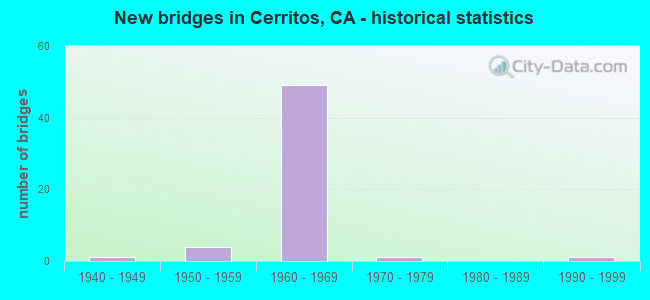
- New bridges - historical statistics
- 11940-1949
- 41950-1959
- 491960-1969
- 11970-1979
- 11990-1999

- Reconstructed bridges - Historical Statistics
- 11950-1959
- 31960-1969
- 11970-1979
- 11980-1989
- 11990-1999


- Bridge Condition - Deck
- 40.0%Good
- 13.3%Satisfactory
- 43.3%Fair
- 3.3%Poor

- Bridge Condition - Superstructure
- 73.3%Good
- 10.0%Satisfactory
- 16.7%Fair

- Bridge Condition - Culverts
- 50.0%Very good
- 50.0%Good
Find on map >> Show street view
Structure Number: 53 1324, Location: 07-LA-091-R17.57-CRTS (Lat: 33.876103, Lng: -118.091483), Route carried "on" structure: City street , Year Built: 1968, Status: Open, Structure Length: 7.41m (24.31ft), Average Daily Traffic: 20,730 (year 2019), Truck Traffic: 4%, Average Future Daily Traffic: 15,250 (year 2038), Design Load: HS 20, Features Intersected: STATE ROUTE 91, Facility Carried by Structure: GRIDLEY ROAD
Minimum Vertical Clearance: 30+ m (98+ ft), Kilometerpoint: 0.000, Lanes on structure: 2, Lanes under structure: 10, Owner: State Highway Agency, Approaching Roadway Width: 9.6m (31.5ft), Material/Design: Concrete continuous, Design/Construction: Box Beam or Girders - Multiple, Number Of Spans In Main Unit: 4, Length of Maximum Span: 25.3m (83.0ft), Curb or Sidewalk Widths: Left: 0.0m, Right: 1.6m (5.2ft), Curb-To-Curb Width: 9.6m (31.5ft), Out-to-Out Width: 12.1m (39.7ft)
Condition: Deck: Good, Superstructure: Good, Substructure: Good, Operating Rating: 35.0 metric tons, Method Used To Determine Operating Rating: Load and Resistance Factor Rating (LRFR) rating reported by rating factor(RF) method using HL-93 loadings, Inventory Rating: 26.9 metric tons, Method Used To Determine Inventory Rating: Load and Resistance Factor Rating (LRFR) rating reported by rating factor(RF) method using HL-93 loadings, Structural Evaluation: Equal to present minimum criteria, Deck Geometry: Meets minimum limits, Underclear: Meets minimum limits, Approach Roadway Alignment: Superior to present desirable criteria, Designated Inspection Frequency: Every 24 months, Inspection Date: August 2021, Deck Structure Type: Concrete Cast-file-Place
Find on map >> Show street view
Structure Number: 53 1334, Location: 07-LA-091-R18.67-CRTS (Lat: 33.876267, Lng: -118.072853), Route carried "on" structure: State highway 91, Year Built: 1968, Status: Open, Structure Length: 4.06m (13.32ft), Average Daily Traffic: 262,000 (year 2019), Truck Traffic: 8%, Average Future Daily Traffic: 219,143 (year 2038), Design Load: HS 20, Features Intersected: NORWALK BLVD
Minimum Vertical Clearance: 30+ m (98+ ft), Kilometerpoint: 18.670, Lanes on structure: 12, Lanes under structure: 4, Base Highway Network: Yes (, Subroute: 1), Owner: State Highway Agency, Approaching Roadway Width: 49.4m (162.1ft), Skew: 30 degrees, Material/Design: Prestressed concrete, Design/Construction: Box Beam or Girders - Multiple, Number Of Spans In Main Unit: 1, Length of Maximum Span: 40.6m (133.2ft), Curb-To-Curb Width: 49.4m (162.1ft), Out-to-Out Width: 50.9m (167.0ft)
Condition: Deck: Satisfactory, Superstructure: Good, Substructure: Good, Operating Rating: 46.0 metric tons, Method Used To Determine Operating Rating: Load and Resistance Factor Rating (LRFR) rating reported by rating factor(RF) method using HL-93 loadings, Inventory Rating: 34.7 metric tons, Method Used To Determine Inventory Rating: Load and Resistance Factor Rating (LRFR) rating reported by rating factor(RF) method using HL-93 loadings, Structural Evaluation: Better than present minimum criteria, Deck Geometry: Equal to present minimum criteria, Underclear: Equal to present minimum criteria, Approach Roadway Alignment: Superior to present desirable criteria, Designated Inspection Frequency: Every 24 months, Inspection Date: August 2021, Deck Structure Type: Concrete Cast-file-Place
Find on map >> Show street view
Structure Number: 53 1431, Location: 07-LA-091-R20.16-CRTS (Lat: 33.866592, Lng: -118.049931), Route carried "on" structure: City street , Year Built: 1969, Status: Open, Structure Length: 9.66m (31.69ft), Average Daily Traffic: 28,500 (year 2019), Truck Traffic: 4%, Average Future Daily Traffic: 36,064 (year 2038), Design Load: HS 20, Features Intersected: STATE ROUTE 91, Facility Carried by Structure: 183RD ST
Minimum Vertical Clearance: 30+ m (98+ ft), Kilometerpoint: 0.000, Lanes on structure: 4, Lanes under structure: 11, Owner: State Highway Agency, Approaching Roadway Width: 16.0m (52.5ft), Skew: 25 degrees, Material/Design: Prestressed concrete continuous, Design/Construction: Box Beam or Girders - Multiple, Number Of Spans In Main Unit: 2, Length of Maximum Span: 49.7m (163.1ft), Curb or Sidewalk Widths: Left: 1.8m (5.9ft), Right: 1.8m (5.9ft), Curb-To-Curb Width: 16.0m (52.5ft), Out-to-Out Width: 21.8m (71.5ft)
Condition: Deck: Good, Superstructure: Good, Substructure: Good, Operating Rating: 94.3 metric tons, Method Used To Determine Operating Rating: Load and Resistance Factor Rating (LRFR) rating reported by rating factor(RF) method using HL-93 loadings, Inventory Rating: 72.9 metric tons, Method Used To Determine Inventory Rating: Load and Resistance Factor Rating (LRFR) rating reported by rating factor(RF) method using HL-93 loadings, Structural Evaluation: Better than present minimum criteria, Deck Geometry: Meets minimum limits, Underclear: Meets minimum limits, Approach Roadway Alignment: Superior to present desirable criteria, Designated Inspection Frequency: Every 24 months, Inspection Date: August 2021, Deck Structure Type: Concrete Cast-file-Place
Find on map >> Show street view
Structure Number: 53 1432, Location: 07-LA-091-R20.45-CRTS (Lat: 33.863653, Lng: -118.046183), Route carried "on" structure: City street , Year Built: 1969, Status: Open, Structure Length: 6.28m (20.60ft), Average Daily Traffic: 27,200 (year 2019), Truck Traffic: 4%, Average Future Daily Traffic: 32,973 (year 2038), Design Load: HS 20, Features Intersected: STATE ROUTE 91, Facility Carried by Structure: CARMENITA ROAD
Minimum Vertical Clearance: 30+ m (98+ ft), Kilometerpoint: 0.000, Lanes on structure: 4, Lanes under structure: 10, Owner: State Highway Agency, Approaching Roadway Width: 21.2m (69.6ft), Skew: 23 degrees, Material/Design: Concrete continuous, Design/Construction: Box Beam or Girders - Multiple, Number Of Spans In Main Unit: 2, Length of Maximum Span: 30.8m (101.0ft), Curb or Sidewalk Widths: Left: 1.8m (5.9ft), Right: 1.8m (5.9ft), Curb-To-Curb Width: 21.2m (69.6ft), Out-to-Out Width: 30.3m (99.4ft)
Condition: Deck: Good, Superstructure: Good, Substructure: Good, Operating Rating: 53.8 metric tons, Method Used To Determine Operating Rating: Load and Resistance Factor Rating (LRFR) rating reported by rating factor(RF) method using HL-93 loadings, Inventory Rating: 38.9 metric tons, Method Used To Determine Inventory Rating: Load and Resistance Factor Rating (LRFR) rating reported by rating factor(RF) method using HL-93 loadings, Structural Evaluation: Better than present minimum criteria, Deck Geometry: Superior to present desirable criteria, Underclear: Meets minimum limits, Approach Roadway Alignment: Superior to present desirable criteria, Designated Inspection Frequency: Every 24 months, Inspection Date: August 2021, Deck Structure Type: Concrete Cast-file-Place
Find on map >> Show street view
Structure Number: 53 1433, Location: 07-LA-091-R19.17-CRTS (Lat: 33.875764, Lng: -118.064019), Route carried "on" structure: City street , Year Built: 1968, Status: Open, Structure Length: 7.07m (23.20ft), Average Daily Traffic: 21,000 (year 2019), Truck Traffic: 4%, Average Future Daily Traffic: 25,760 (year 2038), Design Load: HS 20, Features Intersected: STATE ROUTE 91, Facility Carried by Structure: BLOOMFIELD AVE
Minimum Vertical Clearance: 30+ m (98+ ft), Kilometerpoint: 0.000, Lanes on structure: 4, Lanes under structure: 10, Owner: State Highway Agency, Approaching Roadway Width: 16.0m (52.5ft), Skew: 2 degrees, Material/Design: Concrete continuous, Design/Construction: Box Beam or Girders - Multiple, Number Of Spans In Main Unit: 4, Length of Maximum Span: 24.7m (81.0ft), Curb or Sidewalk Widths: Left: 0.0m, Right: 1.7m (5.6ft), Curb-To-Curb Width: 16.0m (52.5ft), Out-to-Out Width: 19.6m (64.3ft)
Condition: Deck: Good, Superstructure: Fair, Substructure: Good, Operating Rating: 48.9 metric tons, Method Used To Determine Operating Rating: Load and Resistance Factor Rating (LRFR) rating reported by rating factor(RF) method using HL-93 loadings, Inventory Rating: 37.6 metric tons, Method Used To Determine Inventory Rating: Load and Resistance Factor Rating (LRFR) rating reported by rating factor(RF) method using HL-93 loadings, Structural Evaluation: Somewhat better than minimum adequacy, Deck Geometry: Meets minimum limits, Underclear: Meets minimum limits, Approach Roadway Alignment: Superior to present desirable criteria, Designated Inspection Frequency: Every 24 months, Inspection Date: August 2021, Deck Structure Type: Concrete Cast-file-Place
Find on map >> Show street view
Structure Number: 53 1434, Location: 07-LA-091-R19.43-CRTS (Lat: 33.873117, Lng: -118.060692), Route carried "on" structure: City street , Year Built: 1968, Status: Open, Structure Length: 10.12m (33.20ft), Average Daily Traffic: 22,700 (year 2019), Truck Traffic: 4%, Average Future Daily Traffic: 26,791 (year 2038), Design Load: HS 20, Features Intersected: STATE ROUTE 91, Facility Carried by Structure: ARTESIA BLVD
Minimum Vertical Clearance: 30+ m (98+ ft), Kilometerpoint: 0.000, Lanes on structure: 4, Lanes under structure: 10, Owner: State Highway Agency, Approaching Roadway Width: 17.1m (56.1ft), Skew: 5 degrees, Material/Design: Concrete continuous, Design/Construction: Box Beam or Girders - Multiple, Number Of Spans In Main Unit: 4, Length of Maximum Span: 34.1m (111.9ft), Curb or Sidewalk Widths: Left: 1.6m (5.2ft), Right: 0.0m, Curb-To-Curb Width: 17.1m (56.1ft), Out-to-Out Width: 19.5m (64.0ft)
Condition: Deck: Good, Superstructure: Good, Substructure: Good, Operating Rating: 57.3 metric tons, Method Used To Determine Operating Rating: Load and Resistance Factor Rating (LRFR) rating reported by rating factor(RF) method using HL-93 loadings, Inventory Rating: 41.1 metric tons, Method Used To Determine Inventory Rating: Load and Resistance Factor Rating (LRFR) rating reported by rating factor(RF) method using HL-93 loadings, Structural Evaluation: Better than present minimum criteria, Deck Geometry: Somewhat better than minimum adequacy, Underclear: Meets minimum limits, Approach Roadway Alignment: Superior to present desirable criteria, Designated Inspection Frequency: Every 24 months, Inspection Date: August 2021, Deck Structure Type: Concrete Cast-file-Place
Find on map >> Show street view
Structure Number: 53 1703G, Location: 07-LA-091-R16.97-CRTS (Lat: 33.874456, Lng: -118.102217), Route carried "on" structure: Ramp State highway 91, Year Built: 1966, Status: Open, Structure Length: 8.60m (28.22ft), Average Daily Traffic: 27,000 (year 2019), Truck Traffic: 2%, Average Future Daily Traffic: 29,745 (year 2038), Design Load: HS 20, Features Intersected: 605 & W91-S605 CONN
Minimum Vertical Clearance: 30+ m (98+ ft), Kilometerpoint: 16.970, Lanes on structure: 2, Lanes under structure: 9, Base Highway Network: Yes (, Subroute: 1), Owner: State Highway Agency, Approaching Roadway Width: 9.6m (31.5ft), Skew: 9 degrees, Material/Design: Concrete continuous, Design/Construction: Box Beam or Girders - Multiple, Number Of Spans In Main Unit: 4, Length of Maximum Span: 28.0m (91.9ft), Curb-To-Curb Width: 9.6m (31.5ft), Out-to-Out Width: 10.4m (34.1ft)
Condition: Deck: Poor, Superstructure: Good, Substructure: Good, Operating Rating: 38.2 metric tons, Method Used To Determine Operating Rating: Load and Resistance Factor Rating (LRFR) rating reported by rating factor(RF) method using HL-93 loadings, Inventory Rating: 29.5 metric tons, Method Used To Determine Inventory Rating: Load and Resistance Factor Rating (LRFR) rating reported by rating factor(RF) method using HL-93 loadings, Structural Evaluation: Better than present minimum criteria, Deck Geometry: Somewhat better than minimum adequacy, Underclear: Somewhat better than minimum adequacy, Approach Roadway Alignment: High priority of corrective action, Designated Inspection Frequency: Every 24 months, Inspection Date: August 2021, Deck Structure Type: Concrete Cast-file-Place, Wearing Surface/Protective System: Wearing Surface: Integral Concrete
Find on map >> Show street view
Structure Number: 53 1704, Location: 07-LA-091-R16.90-CRTS (Lat: 33.876144, Lng: -118.103153), Route carried "on" structure: State highway 91, Year Built: 1966, Year Reconstructed: 1994, Status: Open, Structure Length: 15.06m (49.41ft), Average Daily Traffic: 242,000 (year 2019), Truck Traffic: 12%, Average Future Daily Traffic: 258,112 (year 2038), Design Load: HS 20, Features Intersected: SR 605 & RAMPS
Minimum Vertical Clearance: 30+ m (98+ ft), Kilometerpoint: 16.900, Lanes on structure: 10, Lanes under structure: 13, Base Highway Network: Yes (, Subroute: 1), Owner: State Highway Agency, Approaching Roadway Width: 44.1m (144.7ft), Skew: 21 degrees, Material/Design: Concrete continuous, Design/Construction: Box Beam or Girders - Multiple, Number Of Spans In Main Unit: 6, Length of Maximum Span: 27.8m (91.2ft), Curb-To-Curb Width: 44.1m (144.7ft), Out-to-Out Width: 45.6m (149.6ft)
Condition: Deck: Fair, Superstructure: Good, Substructure: Good, Operating Rating: 68.6 metric tons, Method Used To Determine Operating Rating: Load Factor (LF), Inventory Rating: 41.4 metric tons, Method Used To Determine Inventory Rating: Load Factor (LF), Structural Evaluation: Better than present minimum criteria, Deck Geometry: Better than present minimum criteria, Underclear: High priority of corrective action, Approach Roadway Alignment: Superior to present desirable criteria, Designated Inspection Frequency: Every 24 months, Inspection Date: August 2021, Deck Structure Type: Concrete Cast-file-Place
Find on map >> Show street view
Structure Number: 53 1705F, Location: 07-LA-091-R16.93-CRTS (Lat: 33.877672, Lng: -118.103300), Route carried "on" structure: Ramp State highway 91, Year Built: 1966, Status: Open, Structure Length: 9.02m (29.59ft), Average Daily Traffic: 26,900 (year 2019), Truck Traffic: 2%, Average Future Daily Traffic: 33,159 (year 2038), Design Load: HS 20, Features Intersected: ROUTE 605
Minimum Vertical Clearance: 30+ m (98+ ft), Kilometerpoint: 16.930, Lanes on structure: 1, Lanes under structure: 9, Base Highway Network: Yes (, Subroute: 1), Owner: State Highway Agency, Approaching Roadway Width: 7.1m (23.3ft), Skew: 9 degrees, Material/Design: Concrete continuous, Design/Construction: Box Beam or Girders - Multiple, Number Of Spans In Main Unit: 4, Length of Maximum Span: 32.4m (106.3ft), Curb-To-Curb Width: 7.1m (23.3ft), Out-to-Out Width: 7.9m (25.9ft)
Condition: Deck: Satisfactory, Superstructure: Good, Substructure: Good, Operating Rating: 40.2 metric tons, Method Used To Determine Operating Rating: Load and Resistance Factor Rating (LRFR) rating reported by rating factor(RF) method using HL-93 loadings, Inventory Rating: 30.8 metric tons, Method Used To Determine Inventory Rating: Load and Resistance Factor Rating (LRFR) rating reported by rating factor(RF) method using HL-93 loadings, Structural Evaluation: Better than present minimum criteria, Deck Geometry: Equal to present minimum criteria, Underclear: Somewhat better than minimum adequacy, Approach Roadway Alignment: Somewhat better than minimum adequacy, Designated Inspection Frequency: Every 24 months, Inspection Date: August 2021, Deck Structure Type: Concrete Cast-file-Place
Find on map >> Show street view
Structure Number: 53 1706, Location: 07-LA-091-R17.08-CRTS (Lat: 33.876203, Lng: -118.100019), Route carried "on" structure: State highway 91, Year Built: 1968, Status: Open, Structure Length: 4.36m (14.30ft), Average Daily Traffic: 270,000 (year 2019), Truck Traffic: 7%, Average Future Daily Traffic: 258,112 (year 2038), Design Load: HS 20, Features Intersected: STUDEBAKER ROAD
Minimum Vertical Clearance: 30+ m (98+ ft), Kilometerpoint: 17.080, Lanes on structure: 10, Lanes under structure: 5, Base Highway Network: Yes (, Subroute: 1), Owner: State Highway Agency, Approaching Roadway Width: 44.9m (147.3ft), Skew: 30 degrees, Material/Design: Prestressed concrete, Design/Construction: Box Beam or Girders - Multiple, Number Of Spans In Main Unit: 1, Length of Maximum Span: 43.6m (143.0ft), Curb-To-Curb Width: 44.9m (147.3ft), Out-to-Out Width: 46.3m (151.9ft)
Condition: Deck: Good, Superstructure: Good, Substructure: Good, Operating Rating: 99.8 metric tons, Method Used To Determine Operating Rating: Load Factor (LF), Inventory Rating: 32.4 metric tons, Method Used To Determine Inventory Rating: Load Factor (LF), Structural Evaluation: Better than present minimum criteria, Deck Geometry: Superior to present desirable criteria, Underclear: Meets minimum limits, Approach Roadway Alignment: Superior to present desirable criteria, Designated Inspection Frequency: Every 24 months, Inspection Date: August 2021, Deck Structure Type: Concrete Cast-file-Place
Find on map >> Show street view
Structure Number: 53 1707F, Location: 07-LA-091-R17.09-CRTS (Lat: 33.877628, Lng: -118.100022), Route carried "on" structure: Ramp State highway 91, Year Built: 1968, Status: Open, Structure Length: 4.67m (15.32ft), Average Daily Traffic: 40,000 (year 2019), Truck Traffic: 6%, Average Future Daily Traffic: 45,051 (year 2038), Design Load: HS 20, Features Intersected: STUDEBAKER ROAD
Minimum Vertical Clearance: 30+ m (98+ ft), Kilometerpoint: 17.090, Lanes on structure: 2, Lanes under structure: 4, Base Highway Network: Yes (, Subroute: 1), Owner: State Highway Agency, Approaching Roadway Width: 10.4m (34.1ft), Skew: 2 degrees, Material/Design: Prestressed concrete, Design/Construction: Box Beam or Girders - Multiple, Number Of Spans In Main Unit: 1, Length of Maximum Span: 46.7m (153.2ft), Curb or Sidewalk Widths: Left: 0.0m, Right: 0.6m (2.0ft), Curb-To-Curb Width: 10.4m (34.1ft), Out-to-Out Width: 11.6m (38.1ft)
Condition: Deck: Fair, Superstructure: Good, Substructure: Good, Operating Rating: 48.3 metric tons, Method Used To Determine Operating Rating: Load and Resistance Factor Rating (LRFR) rating reported by rating factor(RF) method using HL-93 loadings, Inventory Rating: 27.2 metric tons, Method Used To Determine Inventory Rating: Load and Resistance Factor Rating (LRFR) rating reported by rating factor(RF) method using HL-93 loadings, Structural Evaluation: Equal to present minimum criteria, Deck Geometry: Better than present minimum criteria, Underclear: Somewhat better than minimum adequacy, Approach Roadway Alignment: Superior to present desirable criteria, Designated Inspection Frequency: Every 24 months, Inspection Date: August 2021, Deck Structure Type: Concrete Cast-file-Place
Find on map >> Show street view
Structure Number: 53 1711, Location: 07-LA-605-R4.26-CRTS (Lat: 33.865439, Lng: -118.098253), Route carried "on" structure: Interstate 605, Year Built: 1966, Status: Open, Structure Length: 4.71m (15.45ft), Average Daily Traffic: 245,000 (year 2012), Truck Traffic: 5%, Average Future Daily Traffic: 257,261 (year 2039), Design Load: HS 20, Features Intersected: 183RD STREET
Minimum Vertical Clearance: 30+ m (98+ ft), Kilometerpoint: 4.260, Lanes on structure: 12, Lanes under structure: 5, Base Highway Network: Yes (Inventory Route: 6, Subroute: 3), Owner: State Highway Agency, Approaching Roadway Width: 47.4m (155.5ft), Skew: 31 degrees, Material/Design: Concrete continuous, Design/Construction: Box Beam or Girders - Multiple, Number Of Spans In Main Unit: 3, Length of Maximum Span: 26.4m (86.6ft), Curb-To-Curb Width: 47.4m (155.5ft), Out-to-Out Width: 48.8m (160.1ft)
Condition: Deck: Fair, Superstructure: Good, Substructure: Good, Operating Rating: 35.3 metric tons, Method Used To Determine Operating Rating: Load and Resistance Factor Rating (LRFR) rating reported by rating factor(RF) method using HL-93 loadings, Inventory Rating: 27.2 metric tons, Method Used To Determine Inventory Rating: Load and Resistance Factor Rating (LRFR) rating reported by rating factor(RF) method using HL-93 loadings, Structural Evaluation: Equal to present minimum criteria, Deck Geometry: Meets minimum limits, Underclear: High priority of corrective action, Approach Roadway Alignment: Superior to present desirable criteria, Designated Inspection Frequency: Every 24 months, Inspection Date: June 2021, Deck Structure Type: Concrete Cast-file-Place
Find on map >> Show street view
Structure Number: 53 1721, Location: 07-LA-605-R4.71-CRTS (Lat: 33.871489, Lng: -118.100406), Route carried "on" structure: Interstate 605, Year Built: 1966, Status: Open, Structure Length: 1.60m (5.25ft), Average Daily Traffic: 245,000 (year 2012), Truck Traffic: 5%, Average Future Daily Traffic: 257,261 (year 2040), Design Load: HS 20, Features Intersected: UP RR & LACMTA
Minimum Vertical Clearance: 30+ m (98+ ft), Kilometerpoint: 4.710, Lanes on structure: 12, Base Highway Network: Yes (Inventory Route: 6, Subroute: 3), Owner: State Highway Agency, Approaching Roadway Width: 59.7m (195.9ft), Skew: 35 degrees, Material/Design: Concrete, Design/Construction: Slab, Number Of Spans In Main Unit: 1, Length of Maximum Span: 8.5m (27.9ft), Curb-To-Curb Width: 57.7m (189.3ft), Out-to-Out Width: 61.1m (200.5ft)
Condition: Deck: Good, Superstructure: Good, Substructure: Good, Operating Rating: 94.3 metric tons, Method Used To Determine Operating Rating: Load Factor (LF), Inventory Rating: 56.4 metric tons, Method Used To Determine Inventory Rating: Load Factor (LF), Structural Evaluation: Better than present minimum criteria, Deck Geometry: Superior to present desirable criteria, Underclear: Meets minimum limits, Approach Roadway Alignment: Superior to present desirable criteria, Designated Inspection Frequency: Every 24 months, Inspection Date: June 2021, Deck Structure Type: Concrete Cast-file-Place
Find on map >> Show street view
Structure Number: 53 1725, Location: 07-LA-605-R2.87-CRTS (Lat: 33.845819, Lng: -118.092825), Route carried "on" structure: City street L073, Year Built: 1966, Status: Open, Structure Length: 8.72m (28.61ft), Average Daily Traffic: 34,500 (year 2012), Truck Traffic: 4%, Average Future Daily Traffic: 47,399 (year 2040), Design Load: HS 20, Features Intersected: INTERSTATE 605, Facility Carried by Structure: DEL AMO BLVD
Minimum Vertical Clearance: 30+ m (98+ ft), Kilometerpoint: 0.000, Lanes on structure: 4, Lanes under structure: 10, Owner: State Highway Agency, Approaching Roadway Width: 23.2m (76.1ft), Skew: 2 degrees, Material/Design: Concrete continuous, Design/Construction: Box Beam or Girders - Multiple, Number Of Spans In Main Unit: 4, Length of Maximum Span: 31.1m (102.0ft), Curb or Sidewalk Widths: Left: 1.5m (4.9ft), Right: 1.5m (4.9ft), Curb-To-Curb Width: 23.2m (76.1ft), Out-to-Out Width: 28.7m (94.2ft)
Condition: Deck: Fair, Superstructure: Fair, Substructure: Good, Operating Rating: 58.6 metric tons, Method Used To Determine Operating Rating: Load and Resistance Factor Rating (LRFR) rating reported by rating factor(RF) method using HL-93 loadings, Inventory Rating: 42.1 metric tons, Method Used To Determine Inventory Rating: Load and Resistance Factor Rating (LRFR) rating reported by rating factor(RF) method using HL-93 loadings, Structural Evaluation: Somewhat better than minimum adequacy, Deck Geometry: Superior to present desirable criteria, Underclear: Equal to present minimum criteria, Approach Roadway Alignment: Superior to present desirable criteria, Designated Inspection Frequency: Every 24 months, Inspection Date: June 2021, Deck Structure Type: Concrete Cast-file-Place
Find on map >> Show street view
Structure Number: 53 173, Location: 07-LA-101-31.91 (Lat: 34.140644, Lng: -118.709417), Route carried "on" structure: County highway W485, Year Built: 1965, Status: Open, Structure Length: 6.51m (21.36ft), Average Daily Traffic: 6,500 (year 2018), Truck Traffic: 1%, Average Future Daily Traffic: 8,074 (year 2040), Design Load: HS 20, Features Intersected: ROUTE 101, Facility Carried by Structure: LOST HILLS RD
Minimum Vertical Clearance: 30+ m (98+ ft), Kilometerpoint: 0.000, Lanes on structure: 2, Lanes under structure: 8, Base Highway Network: Yes, Owner: State Highway Agency, Approaching Roadway Width: 21.9m (71.9ft), Material/Design: Prestressed concrete, Design/Construction: Stringer/Multi-beam, Number Of Spans In Main Unit: 2, Number Of Approach Spans: 2, Length of Maximum Span: 27.6m (90.6ft), Curb or Sidewalk Widths: Left: 2.1m (6.9ft), Right: 0.0m, Curb-To-Curb Width: 21.9m (71.9ft), Out-to-Out Width: 24.6m (80.7ft)
Condition: Deck: Fair, Superstructure: Good, Substructure: Good, Operating Rating: 41.8 metric tons, Method Used To Determine Operating Rating: Load and Resistance Factor Rating (LRFR) rating reported by rating factor(RF) method using HL-93 loadings, Inventory Rating: 30.1 metric tons, Method Used To Determine Inventory Rating: Load and Resistance Factor Rating (LRFR) rating reported by rating factor(RF) method using HL-93 loadings, Structural Evaluation: Better than present minimum criteria, Deck Geometry: Superior to present desirable criteria, Underclear: High priority of corrective action, Approach Roadway Alignment: Equal to present desirable criteria, Designated Inspection Frequency: Every 24 months, Inspection Date: May 2020, Deck Structure Type: Concrete Cast-file-Place, Wearing Surface/Protective System: Wearing Surface: Monolithic Concrete
Find on map >> Show street view
Structure Number: 53 1732, Location: 07-LA-605-R3.75-CRTS (Lat: 33.858258, Lng: -118.096572), Route carried "on" structure: City street L074, Year Built: 1966, Status: Open, Structure Length: 8.05m (26.41ft), Average Daily Traffic: 16,700 (year 2012), Truck Traffic: 2%, Average Future Daily Traffic: 22,668 (year 2040), Design Load: HS 20, Features Intersected: INTERSTATE 605, Facility Carried by Structure: SOUTH STREET
Minimum Vertical Clearance: 30+ m (98+ ft), Kilometerpoint: 0.000, Lanes on structure: 6, Lanes under structure: 10, Base Highway Network: Yes, Owner: State Highway Agency, Approaching Roadway Width: 22.2m (72.8ft), Skew: 21 degrees, Material/Design: Concrete continuous, Design/Construction: Box Beam or Girders - Multiple, Number Of Spans In Main Unit: 4, Length of Maximum Span: 28.8m (94.5ft), Curb or Sidewalk Widths: Left: 1.6m (5.2ft), Right: 1.6m (5.2ft), Curb-To-Curb Width: 22.2m (72.8ft), Out-to-Out Width: 28.7m (94.2ft)
Condition: Deck: Fair, Superstructure: Fair, Substructure: Good, Operating Rating: 40.2 metric tons, Method Used To Determine Operating Rating: Load and Resistance Factor Rating (LRFR) rating reported by rating factor(RF) method using HL-93 loadings, Inventory Rating: 30.8 metric tons, Method Used To Determine Inventory Rating: Load and Resistance Factor Rating (LRFR) rating reported by rating factor(RF) method using HL-93 loadings, Structural Evaluation: Somewhat better than minimum adequacy, Deck Geometry: Meets minimum limits, Underclear: Equal to present minimum criteria, Approach Roadway Alignment: Superior to present desirable criteria, Designated Inspection Frequency: Every 24 months, Inspection Date: June 2021, Deck Structure Type: Concrete Cast-file-Place
Find on map >> Show street view
Structure Number: 53 1733, Location: 07-LA-605-R4.39-CRTS (Lat: 33.867633, Lng: -118.099053), Route carried "on" structure: Interstate 605, Year Built: 1966, Status: Open, Structure Length: 7.76m (25.46ft), Average Daily Traffic: 245,000 (year 2012), Truck Traffic: 5%, Average Future Daily Traffic: 257,261 (year 2039), Design Load: HS 20, Features Intersected: STUDEBAKER ROAD
Minimum Vertical Clearance: 30+ m (98+ ft), Kilometerpoint: 4.390, Lanes on structure: 12, Lanes under structure: 4, Base Highway Network: Yes (Inventory Route: 6, Subroute: 3), Owner: State Highway Agency, Approaching Roadway Width: 47.6m (156.2ft), Skew: 35 degrees, Material/Design: Concrete continuous, Design/Construction: Box Beam or Girders - Multiple, Number Of Spans In Main Unit: 4, Length of Maximum Span: 22.7m (74.5ft), Curb-To-Curb Width: 47.6m (156.2ft), Out-to-Out Width: 48.8m (160.1ft)
Condition: Deck: Fair, Superstructure: Good, Substructure: Good, Operating Rating: 44.7 metric tons, Method Used To Determine Operating Rating: Load and Resistance Factor Rating (LRFR) rating reported by rating factor(RF) method using HL-93 loadings, Inventory Rating: 34.7 metric tons, Method Used To Determine Inventory Rating: Load and Resistance Factor Rating (LRFR) rating reported by rating factor(RF) method using HL-93 loadings, Structural Evaluation: Better than present minimum criteria, Deck Geometry: Meets minimum limits, Underclear: High priority of corrective action, Approach Roadway Alignment: Superior to present desirable criteria, Designated Inspection Frequency: Every 24 months, Inspection Date: June 2021, Deck Structure Type: Concrete Cast-file-Place
Find on map >> Show street view
Structure Number: 53 1735, Location: 07-LA-605-R4.77-CRTS (Lat: 33.872692, Lng: -118.100922), Route carried "on" structure: Interstate 605, Year Built: 1966, Status: Open, Structure Length: 5.28m (17.32ft), Average Daily Traffic: 245,000 (year 2012), Truck Traffic: 5%, Average Future Daily Traffic: 257,261 (year 2040), Design Load: HS 20, Features Intersected: ARTESIA BLVD
Minimum Vertical Clearance: 30+ m (98+ ft), Kilometerpoint: 4.770, Lanes on structure: 9, Lanes under structure: 4, Base Highway Network: Yes (Inventory Route: 6, Subroute: 3), Owner: State Highway Agency, Approaching Roadway Width: 41.3m (135.5ft), Skew: 31 degrees, Material/Design: Concrete continuous, Design/Construction: Box Beam or Girders - Multiple, Number Of Spans In Main Unit: 2, Length of Maximum Span: 27.3m (89.6ft), Curb-To-Curb Width: 41.3m (135.5ft), Out-to-Out Width: 42.7m (140.1ft)
Condition: Deck: Fair, Superstructure: Fair, Substructure: Good, Operating Rating: 32.7 metric tons, Method Used To Determine Operating Rating: Load and Resistance Factor Rating (LRFR) rating reported by rating factor(RF) method using HL-93 loadings, Inventory Rating: 25.3 metric tons, Method Used To Determine Inventory Rating: Load and Resistance Factor Rating (LRFR) rating reported by rating factor(RF) method using HL-93 loadings, Structural Evaluation: Somewhat better than minimum adequacy, Deck Geometry: Superior to present desirable criteria, Underclear: Somewhat better than minimum adequacy, Approach Roadway Alignment: Superior to present desirable criteria, Length Of Structure Improvement: 5.27m (17.29ft), Designated Inspection Frequency: Every 24 months, Inspection Date: June 2021, Deck Structure Type: Concrete Cast-file-Place
Find on map >> Show street view
Structure Number: 53 1735G, Location: 07-LA-605-R4.78-CRTS (Lat: 33.872692, Lng: -118.100781), Route carried "on" structure: Ramp Interstate 605, Year Built: 1966, Status: Open, Structure Length: 5.43m (17.81ft), Average Daily Traffic: 43,475 (year 2012), Truck Traffic: 2%, Average Future Daily Traffic: 50,464 (year 2040), Design Load: HS 20, Features Intersected: ARTESIA BLVD
Minimum Vertical Clearance: 30+ m (98+ ft), Kilometerpoint: 4.780, Lanes on structure: 2, Lanes under structure: 4, Owner: State Highway Agency, Approaching Roadway Width: 10.4m (34.1ft), Skew: 1 degrees, Material/Design: Concrete continuous, Design/Construction: Box Beam or Girders - Multiple, Number Of Spans In Main Unit: 2, Length of Maximum Span: 27.4m (89.9ft), Curb or Sidewalk Widths: Left: 0.6m (2.0ft), Right: 0.0m, Curb-To-Curb Width: 10.4m (34.1ft), Out-to-Out Width: 11.6m (38.1ft)
Condition: Deck: Fair, Superstructure: Good, Substructure: Good, Operating Rating: 44.1 metric tons, Method Used To Determine Operating Rating: Load and Resistance Factor Rating (LRFR) rating reported by rating factor(RF) method using HL-93 loadings, Inventory Rating: 34.0 metric tons, Method Used To Determine Inventory Rating: Load and Resistance Factor Rating (LRFR) rating reported by rating factor(RF) method using HL-93 loadings, Structural Evaluation: Better than present minimum criteria, Deck Geometry: Better than present minimum criteria, Underclear: Somewhat better than minimum adequacy, Approach Roadway Alignment: Equal to present desirable criteria, Designated Inspection Frequency: Every 24 months, Inspection Date: June 2021, Deck Structure Type: Concrete Cast-file-Place
Find on map >> Show street view
Structure Number: 53 2708G, Location: 07-LA-091-R16.96-CRTS (Lat: 33.873131, Lng: -118.102061), Route carried "on" structure: Ramp State highway 91, Year Built: 1966, Status: Open, Structure Length: 6.27m (20.57ft), Average Daily Traffic: 24,200 (year 2019), Truck Traffic: 2%, Average Future Daily Traffic: 25,982 (year 2038), Design Load: HS 20, Features Intersected: ARTESIA BLVD
Minimum Vertical Clearance: 30+ m (98+ ft), Kilometerpoint: 16.960, Lanes on structure: 1, Lanes under structure: 4, Owner: State Highway Agency, Approaching Roadway Width: 6.7m (22.0ft), Skew: 3 degrees, Material/Design: Concrete continuous, Design/Construction: Box Beam or Girders - Multiple, Number Of Spans In Main Unit: 2, Length of Maximum Span: 31.5m (103.3ft), Curb or Sidewalk Widths: Left: 0.6m (2.0ft), Right: 0.0m, Curb-To-Curb Width: 6.7m (22.0ft), Out-to-Out Width: 7.9m (25.9ft)
Condition: Deck: Satisfactory, Superstructure: Good, Substructure: Good, Operating Rating: 55.1 metric tons, Method Used To Determine Operating Rating: Load and Resistance Factor Rating (LRFR) rating reported by rating factor(RF) method using HL-93 loadings, Inventory Rating: 42.4 metric tons, Method Used To Determine Inventory Rating: Load and Resistance Factor Rating (LRFR) rating reported by rating factor(RF) method using HL-93 loadings, Structural Evaluation: Better than present minimum criteria, Deck Geometry: Equal to present minimum criteria, Underclear: Somewhat better than minimum adequacy, Approach Roadway Alignment: Equal to present desirable criteria, Designated Inspection Frequency: Every 24 months, Inspection Date: August 2021, Deck Structure Type: Concrete Cast-file-Place
Find on map >> Show street view
Structure Number: 53C0055, Location: 0.4MI W/O I-605 FWY (Lat: 33.858219, Lng: -118.103003), Route carried "on" structure: City street L074, Year Built: 1952, Year Reconstructed: 1972, Status: Open, Structure Length: 9.24m (30.31ft), Average Daily Traffic: 55,839 (year 2018), Truck Traffic: 1%, Average Future Daily Traffic: 65,000 (year 2040), Design Load: HS 20, Features Intersected: SAN GABRIEL RIV, Facility Carried by Structure: SOUTH ST
Minimum Vertical Clearance: 30.47m (99.97ft), Kilometerpoint: 0.000, Lanes on structure: 4, Owner: City or Municipal Highway Agency, Approaching Roadway Width: 19.2m (63.0ft), Skew: 21 degrees, Material/Design: Concrete continuous, Design/Construction: Tee Beam, Number Of Spans In Main Unit: 5, Length of Maximum Span: 20.4m (66.9ft), Curb or Sidewalk Widths: Left: 1.5m (4.9ft), Right: 1.5m (4.9ft), Curb-To-Curb Width: 19.3m (63.3ft), Out-to-Out Width: 26.3m (86.3ft)
Condition: Deck: Good, Superstructure: Good, Substructure: Good, Channel: Excellent, Operating Rating: 63.5 metric tons, Method Used To Determine Operating Rating: Load Factor (LF), Inventory Rating: 38.2 metric tons, Method Used To Determine Inventory Rating: Load Factor (LF), Structural Evaluation: Better than present minimum criteria, Deck Geometry: Equal to present minimum criteria, Waterway Adequacy: Equal to present desirable criteria, Approach Roadway Alignment: Equal to present desirable criteria, Designated Inspection Frequency: Every 48 months, Inspection Date: May 2020, Deck Structure Type: Concrete Cast-file-Place
Find on map >> Show street view
Structure Number: 53C0325, Location: 0.3MI E/O CARMENITA RD (Lat: 33.858639, Lng: -118.043533), Route carried "on" structure: City street L074, Year Built: 1951, Year Reconstructed: 1963, Status: Open, Structure Length: 10.58m (34.71ft), Average Daily Traffic: 22,718 (year 2018), Truck Traffic: 2%, Average Future Daily Traffic: 27,019 (year 2040), Design Load: HS 20, Features Intersected: COYOTE CR, Facility Carried by Structure: South ST
Minimum Vertical Clearance: 30.47m (99.97ft), Kilometerpoint: 0.000, Lanes on structure: 4, Owner: City or Municipal Highway Agency, Approaching Roadway Width: 23.2m (76.1ft), Skew: 4 degrees, Material/Design: Concrete continuous, Design/Construction: Box Beam or Girders - Multiple, Number Of Spans In Main Unit: 2, Number Of Approach Spans: 2, Length of Maximum Span: 31.4m (103.0ft), Curb or Sidewalk Widths: Left: 1.2m (3.9ft), Right: 1.3m (4.3ft), Curb-To-Curb Width: 14.6m (47.9ft), Out-to-Out Width: 17.8m (58.4ft)
Condition: Deck: Fair, Superstructure: Satisfactory, Substructure: Good, Channel: Excellent, Operating Rating: 58.0 metric tons, Method Used To Determine Operating Rating: Load Factor (LF), Inventory Rating: 34.7 metric tons, Method Used To Determine Inventory Rating: Load Factor (LF), Structural Evaluation: Equal to present minimum criteria, Deck Geometry: High priority of replacement, Waterway Adequacy: Superior to present desirable criteria, Approach Roadway Alignment: Equal to present desirable criteria, Designated Inspection Frequency: Every 24 months, Inspection Date: June 2020, Deck Structure Type: Concrete Cast-file-Place
Find on map >> Show street view
Structure Number: 53C0326, Location: 0.1MI S/O S ST (Lat: 33.856142, Lng: -118.046031), Route carried "on" structure: City street L095, Year Built: 1958, Year Reconstructed: 2001, Status: Open, Structure Length: 8.56m (28.08ft), Average Daily Traffic: 28,988 (year 2018), Truck Traffic: 1%, Average Future Daily Traffic: 29,936 (year 2040), Design Load: HS 20, Features Intersected: COYOTE CR, Facility Carried by Structure: CARMENITA RD
Minimum Vertical Clearance: 30.47m (99.97ft), Kilometerpoint: 0.000, Lanes on structure: 4, Owner: City or Municipal Highway Agency, Approaching Roadway Width: 25.7m (84.3ft), Skew: 3 degrees, Material/Design: Prestressed concrete, Design/Construction: Stringer/Multi-beam, Number Of Spans In Main Unit: 4, Length of Maximum Span: 20.4m (66.9ft), Curb or Sidewalk Widths: Left: 1.9m (6.2ft), Right: 1.9m (6.2ft), Curb-To-Curb Width: 25.4m (83.3ft), Out-to-Out Width: 29.9m (98.1ft)
Condition: Deck: Satisfactory, Superstructure: Good, Substructure: Good, Channel: Excellent, Operating Rating: 46.0 metric tons, Method Used To Determine Operating Rating: Load Factor (LF), Inventory Rating: 27.5 metric tons, Method Used To Determine Inventory Rating: Load Factor (LF), Structural Evaluation: Equal to present minimum criteria, Deck Geometry: Superior to present desirable criteria, Waterway Adequacy: Equal to present desirable criteria, Approach Roadway Alignment: Equal to present desirable criteria, Designated Inspection Frequency: Every 24 months, Inspection Date: June 2020, Deck Structure Type: Concrete Cast-file-Place
Find on map >> Show street view
Structure Number: 53C0398, Location: 0.3MI W/O I-605 FWY (Lat: 33.872861, Lng: -118.107250), Route carried "on" structure: City street L090, Year Built: 1941, Year Reconstructed: 1966, Status: Open, Structure Length: 11.22m (36.81ft), Average Daily Traffic: 28,353 (year 2018), Truck Traffic: 2%, Average Future Daily Traffic: 28,230 (year 2040), Design Load: HS 20, Features Intersected: SAN GABRIEL RIV, Facility Carried by Structure: ARTESIA BLVD
Minimum Vertical Clearance: 30.47m (99.97ft), Kilometerpoint: 0.000, Lanes on structure: 4, Owner: City or Municipal Highway Agency, Approaching Roadway Width: 22.6m (74.1ft), Skew: 1 degrees, Material/Design: Prestressed concrete, Design/Construction: Tee Beam, Number Of Spans In Main Unit: 7, Length of Maximum Span: 20.4m (66.9ft), Curb or Sidewalk Widths: Left: 1.5m (4.9ft), Right: 2.0m (6.6ft), Curb-To-Curb Width: 15.8m (51.8ft), Out-to-Out Width: 20.3m (66.6ft)
Condition: Deck: Fair, Superstructure: Satisfactory, Substructure: Good, Channel: Excellent, Operating Rating: 53.1 metric tons, Method Used To Determine Operating Rating: Load Factor (LF), Inventory Rating: 31.8 metric tons, Method Used To Determine Inventory Rating: Load Factor (LF), Structural Evaluation: Equal to present minimum criteria, Deck Geometry: Meets minimum limits, Waterway Adequacy: Superior to present desirable criteria, Approach Roadway Alignment: Somewhat better than minimum adequacy, Designated Inspection Frequency: Every 24 months, Inspection Date: June 2020, Deck Structure Type: Concrete Cast-file-Place
Find on map >> Show street view
Structure Number: 53C0417, Location: 0.3MI W/O VALLEY VIEW AV (Lat: 33.873239, Lng: -118.033311), Route carried "on" structure: City street L090, Year Built: 1959, Year Reconstructed: 1967, Status: Open, Structure Length: 5.06m (16.60ft), Average Daily Traffic: 24,866 (year 2018), Truck Traffic: 2%, Average Future Daily Traffic: 28,000 (year 2040), Design Load: HS 20, Features Intersected: COYOTE CRK NF, Facility Carried by Structure: ARTESIA BLVD
Minimum Vertical Clearance: 30.47m (99.97ft), Kilometerpoint: 0.000, Lanes on structure: 4, Owner: City or Municipal Highway Agency, Approaching Roadway Width: 25.6m (84.0ft), Material/Design: Concrete continuous, Design/Construction: Tee Beam, Number Of Spans In Main Unit: 4, Length of Maximum Span: 15.2m (49.9ft), Curb or Sidewalk Widths: Left: 0.6m (2.0ft), Right: 0.6m (2.0ft), Curb-To-Curb Width: 15.8m (51.8ft), Out-to-Out Width: 17.7m (58.1ft)
Condition: Deck: Good, Superstructure: Good, Substructure: Good, Channel: Excellent, Operating Rating: 55.4 metric tons, Method Used To Determine Operating Rating: Load Factor (LF), Inventory Rating: 33.0 metric tons, Method Used To Determine Inventory Rating: Load Factor (LF), Structural Evaluation: Better than present minimum criteria, Deck Geometry: Meets minimum limits, Waterway Adequacy: Superior to present desirable criteria, Approach Roadway Alignment: Somewhat better than minimum adequacy, Designated Inspection Frequency: Every 48 months, Inspection Date: May 2020, Deck Structure Type: Concrete Cast-file-Place, Wearing Surface/Protective System: Wearing Surface: Monolithic Concrete
Find on map >> Show street view
Structure Number: 53C071, Location: 0.1MI W/O BARRANCA AVE (Lat: 34.086078, Lng: -117.877431), Route carried "on" structure: City street L526, Year Built: 1965, Status: Open, Structure Length: 0.94m (3.08ft), Average Daily Traffic: 19,784 (year 2012), Truck Traffic: 2%, Average Future Daily Traffic: 23,741 (year 2041), Design Load: HS 20, Features Intersected: CHARTER OAK WASH, Facility Carried by Structure: BADILLO ST
Minimum Vertical Clearance: 30+ m (98+ ft), Kilometerpoint: 0.000, Lanes on structure: 4, Owner: City or Municipal Highway Agency, Approaching Roadway Width: 21.3m (69.9ft), Skew: 34 degrees, Material/Design: Concrete, Design/Construction: Culvert, Number Of Spans In Main Unit: 1, Length of Maximum Span: 6.1m (20.0ft), Curb or Sidewalk Widths: Left: 1.4m (4.6ft), Right: 1.4m (4.6ft), Curb-To-Curb Width: 21.3m (69.9ft), Out-to-Out Width: 29.6m (97.1ft)
Condition: Channel: Excellent, Culverts: Good, Operating Rating: 54.1 metric tons, Method Used To Determine Operating Rating: Field evaluation and documented engineering judgment, Inventory Rating: 32.4 metric tons, Method Used To Determine Inventory Rating: Field evaluation and documented engineering judgment, Structural Evaluation: Better than present minimum criteria, Deck Geometry: Superior to present desirable criteria, Waterway Adequacy: Superior to present desirable criteria, Approach Roadway Alignment: Equal to present desirable criteria, Designated Inspection Frequency: Every 48 months, Inspection Date: September 2021, Deck Structure Type: Concrete Cast-file-Place, Wearing Surface/Protective System: Wearing Surface: Bituminous
Find on map >> Show street view
Structure Number: 53C0719, Location: 0.4MI W/O I-605 FWY (Lat: 33.845761, Lng: -118.099081), Route carried "on" structure: City street , Year Built: 1966, Status: Open, Structure Length: 5.24m (17.19ft), Average Daily Traffic: 28,629 (year 2012), Truck Traffic: 4%, Average Future Daily Traffic: 34,355 (year 2041), Design Load: HS 20, Features Intersected: SAN GABRIEL RIV, Facility Carried by Structure: DEL AMO BLVD
Minimum Vertical Clearance: 30.47m (99.97ft), Kilometerpoint: 0.000, Lanes on structure: 4, Owner: City or Municipal Highway Agency, Approaching Roadway Width: 20.2m (66.3ft), Skew: 22 degrees, Material/Design: Prestressed concrete, Design/Construction: Stringer/Multi-beam, Number Of Spans In Main Unit: 2, Length of Maximum Span: 25.9m (85.0ft), Curb or Sidewalk Widths: Left: 1.4m (4.6ft), Right: 1.4m (4.6ft), Curb-To-Curb Width: 23.4m (76.8ft), Out-to-Out Width: 28.7m (94.2ft)
Condition: Deck: Fair, Superstructure: Good, Substructure: Good, Channel: Excellent, Operating Rating: 59.6 metric tons, Method Used To Determine Operating Rating: Load Factor (LF), Inventory Rating: 34.3 metric tons, Method Used To Determine Inventory Rating: Load Factor (LF), Structural Evaluation: Better than present minimum criteria, Deck Geometry: Superior to present desirable criteria, Waterway Adequacy: Equal to present desirable criteria, Approach Roadway Alignment: Equal to present desirable criteria, Designated Inspection Frequency: Every 24 months, Inspection Date: January 2021, Deck Structure Type: Concrete Cast-file-Place
Find on map >> Show street view
Structure Number: 53C0792, Location: 0.8MI E/O BLOOMFIELD AVE (Lat: 33.846339, Lng: -118.058672), Route carried "on" structure: City street L073, Year Built: 1965, Status: Open, Structure Length: 8.08m (26.51ft), Average Daily Traffic: 20,793 (year 2018), Truck Traffic: 1%, Average Future Daily Traffic: 22,026 (year 2040), Design Load: HS 20, Features Intersected: COYOTE CR, Facility Carried by Structure: DEL AMO BLVD
Minimum Vertical Clearance: 30.47m (99.97ft), Kilometerpoint: 0.000, Lanes on structure: 2, Owner: City or Municipal Highway Agency, Approaching Roadway Width: 21.3m (69.9ft), Skew: 2 degrees, Material/Design: Steel, Design/Construction: Stringer/Multi-beam, Number Of Spans In Main Unit: 3, Length of Maximum Span: 26.5m (86.9ft), Curb or Sidewalk Widths: Left: 1.5m (4.9ft), Right: 0.6m (2.0ft), Curb-To-Curb Width: 8.4m (27.6ft), Out-to-Out Width: 11.2m (36.7ft)
Condition: Deck: Fair, Superstructure: Satisfactory, Substructure: Good, Channel: Excellent, Operating Rating: 73.9 metric tons, Method Used To Determine Operating Rating: Load Factor (LF), Inventory Rating: 44.4 metric tons, Method Used To Determine Inventory Rating: Load Factor (LF), Structural Evaluation: Equal to present minimum criteria, Deck Geometry: High priority of corrective action, Waterway Adequacy: Equal to present desirable criteria, Approach Roadway Alignment: Equal to present minimum criteria, Designated Inspection Frequency: Every 24 months, Other Special Inspection Frequency: Every 48 months, Inspection Date: June 2020, Other Special Inspection Date: July 2021, Deck Structure Type: Concrete Cast-file-Place
Find on map >> Show street view
Structure Number: 53C0815, Location: 0.2MI S/O ARTESIA BLVD (Lat: 33.870711, Lng: -118.028592), Route carried "on" structure: City street L097, Year Built: 1966, Status: Open, Structure Length: 5.12m (16.80ft), Average Daily Traffic: 21,361 (year 2018), Truck Traffic: 3%, Average Future Daily Traffic: 35,424 (year 2040), Design Load: HS 20, Features Intersected: COYOTE CRK, Facility Carried by Structure: VALLEY VIEW S
Minimum Vertical Clearance: 30.47m (99.97ft), Kilometerpoint: 0.000, Lanes on structure: 3, Owner: City or Municipal Highway Agency, Approaching Roadway Width: 10.7m (35.1ft), Material/Design: Concrete continuous, Design/Construction: Tee Beam, Number Of Spans In Main Unit: 3, Length of Maximum Span: 19.7m (64.6ft), Curb or Sidewalk Widths: Left: 1.5m (4.9ft), Right: 0.6m (2.0ft), Curb-To-Curb Width: 10.7m (35.1ft), Out-to-Out Width: 14.2m (46.6ft)
Condition: Deck: Good, Superstructure: Good, Substructure: Good, Channel: Excellent, Operating Rating: 51.8 metric tons, Method Used To Determine Operating Rating: Load Factor (LF), Inventory Rating: 31.1 metric tons, Method Used To Determine Inventory Rating: Load Factor (LF), Structural Evaluation: Better than present minimum criteria, Deck Geometry: High priority of replacement, Waterway Adequacy: Superior to present desirable criteria, Approach Roadway Alignment: Equal to present desirable criteria, Designated Inspection Frequency: Every 24 months, Inspection Date: June 2020, Deck Structure Type: Concrete Cast-file-Place
Find on map >> Show street view
Structure Number: 53C1026, Location: 0.2MI S/O 183RD ST (Lat: 33.862864, Lng: -118.037517), Route carried "on" structure: City street L096, Year Built: 1965, Status: Open, Structure Length: 11.58m (37.99ft), Average Daily Traffic: 15,963 (year 2018), Truck Traffic: 1%, Average Future Daily Traffic: 17,016 (year 2040), Design Load: HS 20, Features Intersected: COYOTE CR, Facility Carried by Structure: MARQUARDT AVE
Minimum Vertical Clearance: 30.47m (99.97ft), Kilometerpoint: 0.000, Lanes on structure: 2, Owner: City or Municipal Highway Agency, Approaching Roadway Width: 19.4m (63.6ft), Skew: 5 degrees, Material/Design: Steel, Design/Construction: Stringer/Multi-beam, Number Of Spans In Main Unit: 4, Length of Maximum Span: 28.7m (94.2ft), Curb or Sidewalk Widths: Left: 0.6m (2.0ft), Right: 0.8m (2.6ft), Curb-To-Curb Width: 8.4m (27.6ft), Out-to-Out Width: 10.3m (33.8ft)
Condition: Deck: Good, Superstructure: Fair, Substructure: Good, Channel: Excellent, Operating Rating: 96.6 metric tons, Method Used To Determine Operating Rating: Load Factor (LF), Inventory Rating: 57.7 metric tons, Method Used To Determine Inventory Rating: Load Factor (LF), Structural Evaluation: Somewhat better than minimum adequacy, Deck Geometry: High priority of corrective action, Waterway Adequacy: Superior to present desirable criteria, Approach Roadway Alignment: Equal to present desirable criteria, Designated Inspection Frequency: Every 24 months, Other Special Inspection Frequency: Every 48 months, Inspection Date: May 2020, Other Special Inspection Date: July 2021, Deck Structure Type: Concrete Cast-file-Place
Find on map >> Show street view
Structure Number: 53C1475, Location: 0.3MI N/O DEL AMO BLVD (Lat: 33.849031, Lng: -118.063300), Route carried "on" structure: City street L678, Year Built: 1962, Year Reconstructed: 1976, Status: Open, Structure Length: 1.19m (3.90ft), Average Daily Traffic: 21,640 (year 2018), Truck Traffic: 2%, Average Future Daily Traffic: 27,575 (year 2040), Features Intersected: STORM DRN #21, Facility Carried by Structure: BLOOMFIELD AVE
Minimum Vertical Clearance: 30.47m (99.97ft), Kilometerpoint: 0.000, Lanes on structure: 4, Owner: City or Municipal Highway Agency, Approaching Roadway Width: 20.5m (67.3ft), Skew: 23 degrees, Material/Design: Concrete, Design/Construction: Culvert, Number Of Spans In Main Unit: 3, Length of Maximum Span: 3.0m (9.8ft), Curb or Sidewalk Widths: Left: 2.3m (7.5ft), Right: 2.3m (7.5ft), Curb-To-Curb Width: 20.5m (67.3ft), Out-to-Out Width: 30.7m (100.7ft)
Condition: Channel: Excellent, Culverts: Very good, Operating Rating: 40.5 metric tons, Method Used To Determine Operating Rating: Field evaluation and documented engineering judgment, Inventory Rating: 24.3 metric tons, Method Used To Determine Inventory Rating: Field evaluation and documented engineering judgment, Structural Evaluation: Equal to present minimum criteria, Deck Geometry: Superior to present desirable criteria, Waterway Adequacy: Superior to present desirable criteria, Approach Roadway Alignment: Equal to present desirable criteria, Designated Inspection Frequency: Every 24 months, Inspection Date: May 2020
Find on map >> Show street view
Structure Number: 53C1541, Location: 0.3MI W/O STUDEBAKER RD (Lat: 33.865503, Lng: -118.104889), Route carried "on" structure: City street L707, Year Built: 1972, Status: Open, Structure Length: 4.18m (13.71ft), Average Daily Traffic: 16,251 (year 2018), Truck Traffic: 1%, Average Future Daily Traffic: 21,057 (year 2040), Design Load: HS 20, Features Intersected: SAN GABRIEL RIV, Facility Carried by Structure: 183RD ST
Minimum Vertical Clearance: 30.47m (99.97ft), Kilometerpoint: 0.000, Lanes on structure: 4, Owner: City or Municipal Highway Agency, Approaching Roadway Width: 14.9m (48.9ft), Skew: 21 degrees, Material/Design: Prestressed concrete, Design/Construction: Box Beam or Girders - Multiple, Number Of Spans In Main Unit: 1, Length of Maximum Span: 41.5m (136.2ft), Curb or Sidewalk Widths: Left: 2.3m (7.5ft), Right: 2.3m (7.5ft), Curb-To-Curb Width: 15.0m (49.2ft), Out-to-Out Width: 24.7m (81.0ft)
Condition: Deck: Good, Superstructure: Good, Substructure: Good, Channel: Excellent, Operating Rating: 83.3 metric tons, Method Used To Determine Operating Rating: Load Factor (LF), Inventory Rating: 49.9 metric tons, Method Used To Determine Inventory Rating: Load Factor (LF), Structural Evaluation: Better than present minimum criteria, Deck Geometry: High priority of replacement, Waterway Adequacy: Superior to present desirable criteria, Approach Roadway Alignment: Equal to present desirable criteria, Designated Inspection Frequency: Every 24 months, Inspection Date: June 2020, Deck Structure Type: Concrete Cast-file-Place, Wearing Surface/Protective System: Wearing Surface: Monolithic Concrete
Find on map >> Show street view
Structure Number: 53 1324, Location: 07-LA-091-R17.57-CRTS (Lat: 33.876103, Lng: -118.091483), Route carried "under" structure: State highway 91, Year Built: 1968, Structure Length: 0. m, Average Daily Traffic: 30,600 (year 2015), Truck Traffic: 8%, Features Intersected: STATE ROUTE 91, Facility Carried by Structure: GRIDLEY ROAD
Minimum Vertical Clearance: 4.70m (15.42ft), Kilometerpoint: 17.570, Lanes on structure: 2, Lanes under structure: 10, Material/Design: Concrete continuous, Design/Construction: Box Beam or Girders - Multiple, Length of Maximum Span: 25.3m (83.0ft)
Find on map >> Show street view
Structure Number: 53 1334, Location: 07-LA-091-R18.67-CRTS (Lat: 33.876267, Lng: -118.072853), Route carried "under" structure: City street , Year Built: 1968, Structure Length: 0. m, Average Daily Traffic: 29,500 (year 2015), Truck Traffic: 2%, Features Intersected: NORWALK BLVD, Facility Carried by Structure: STATE ROUTE 91
Minimum Vertical Clearance: 4.62m (15.16ft), Kilometerpoint: 0.000, Lanes on structure: 12, Lanes under structure: 4, Material/Design: Prestressed concrete, Design/Construction: Box Beam or Girders - Multiple, Length of Maximum Span: 40.6m (133.2ft)
Find on map >> Show street view
Structure Number: 53 1431, Location: 07-LA-091-R20.16-CRTS (Lat: 33.866592, Lng: -118.049931), Route carried "under" structure: State highway 91, Year Built: 1969, Structure Length: 0. m, Average Daily Traffic: 296,000 (year 2019), Truck Traffic: 8%, Features Intersected: STATE ROUTE 91, Facility Carried by Structure: 183RD ST
Minimum Vertical Clearance: 4.64m (15.22ft), Kilometerpoint: 20.160, Lanes on structure: 4, Lanes under structure: 11, Material/Design: Prestressed concrete continuous, Design/Construction: Box Beam or Girders - Multiple, Length of Maximum Span: 49.7m (163.1ft)
Find on map >> Show street view
Structure Number: 53 1432, Location: 07-LA-091-R20.45-CRTS (Lat: 33.863653, Lng: -118.046183), Route carried "under" structure: State highway 91, Year Built: 1969, Structure Length: 0. m, Average Daily Traffic: 296,000 (year 2015), Truck Traffic: 7%, Features Intersected: STATE ROUTE 91, Facility Carried by Structure: CARMENITA ROAD
Minimum Vertical Clearance: 4.62m (15.16ft), Kilometerpoint: 20.450, Lanes on structure: 4, Lanes under structure: 10, Material/Design: Concrete continuous, Design/Construction: Box Beam or Girders - Multiple, Length of Maximum Span: 30.8m (101.0ft)
Find on map >> Show street view
Structure Number: 53 1433, Location: 07-LA-091-R19.17-CRTS (Lat: 33.875764, Lng: -118.064019), Route carried "under" structure: State highway 91, Year Built: 1968, Structure Length: 0. m, Average Daily Traffic: 296,000 (year 2019), Truck Traffic: 6%, Features Intersected: STATE ROUTE 91, Facility Carried by Structure: BLOOMFIELD AVE
Minimum Vertical Clearance: 5.13m (16.83ft), Kilometerpoint: 19.170, Lanes on structure: 4, Lanes under structure: 10, Material/Design: Concrete continuous, Design/Construction: Box Beam or Girders - Multiple, Length of Maximum Span: 24.7m (81.0ft)
Find on map >> Show street view
Structure Number: 53 1434, Location: 07-LA-091-R19.43-CRTS (Lat: 33.873117, Lng: -118.060692), Route carried "under" structure: State highway 91, Year Built: 1968, Structure Length: 0. m, Average Daily Traffic: 30,600 (year 2015), Truck Traffic: 7%, Features Intersected: STATE ROUTE 91, Facility Carried by Structure: ARTESIA BLVD
Minimum Vertical Clearance: 4.83m (15.85ft), Kilometerpoint: 19.430, Lanes on structure: 4, Lanes under structure: 10, Material/Design: Concrete continuous, Design/Construction: Box Beam or Girders - Multiple, Length of Maximum Span: 34.1m (111.9ft)
Find on map >> Show street view
Structure Number: 53 1703G, Location: 07-LA-091-R16.97-CRTS (Lat: 33.874456, Lng: -118.102217), Route carried "under" structure: Interstate 605, Year Built: 1966, Structure Length: 0. m, Average Daily Traffic: 28,010 (year 2017), Truck Traffic: 2%, Features Intersected: 605 & W91-S605 CONN
Minimum Vertical Clearance: 5.13m (16.83ft), Kilometerpoint: 4.930, Lanes on structure: 2, Lanes under structure: 9, Material/Design: Concrete continuous, Design/Construction: Box Beam or Girders - Multiple, Length of Maximum Span: 28.0m (91.9ft)
Find on map >> Show street view
Structure Number: 53 1704, Location: 07-LA-091-R16.90-CRTS (Lat: 33.876144, Lng: -118.103153), Route carried "under" structure: Ramp Interstate 605, Year Built: 1966, Structure Length: 0. m, Average Daily Traffic: 28,000 (year 2018), Truck Traffic: 6%, Features Intersected: SR 605 & RAMPS, Facility Carried by Structure: STATE ROUTE 91
Minimum Vertical Clearance: 5.63m (18.47ft), Kilometerpoint: 4.750, Lanes on structure: 10, Lanes under structure: 2, Material/Design: Concrete continuous, Design/Construction: Box Beam or Girders - Multiple, Length of Maximum Span: 27.8m (91.2ft)
Find on map >> Show street view
Structure Number: 53 1704, Location: 07-LA-091-R16.90-CRTS (Lat: 33.876144, Lng: -118.103153), Route carried "under" structure: Ramp Interstate 605, Year Built: 1966, Structure Length: 0. m, Average Daily Traffic: 27,000 (year 2018), Truck Traffic: 3%, Features Intersected: SR 605 & RAMPS, Facility Carried by Structure: STATE ROUTE 91
Minimum Vertical Clearance: 5.58m (18.31ft), Kilometerpoint: 4.780, Lanes on structure: 10, Lanes under structure: 1, Material/Design: Concrete continuous, Design/Construction: Box Beam or Girders - Multiple, Length of Maximum Span: 27.8m (91.2ft)
Find on map >> Show street view
Structure Number: 53 1704, Location: 07-LA-091-R16.90-CRTS (Lat: 33.876144, Lng: -118.103153), Route carried "under" structure: Interstate 605, Year Built: 1966, Structure Length: 0. m, Average Daily Traffic: 30,100 (year 2019), Truck Traffic: 6%, Features Intersected: SR 605 & RAMPS, Facility Carried by Structure: STATE ROUTE 91
Minimum Vertical Clearance: 6.83m (22.41ft), Kilometerpoint: 5.050, Lanes on structure: 10, Lanes under structure: 8, Material/Design: Concrete continuous, Design/Construction: Box Beam or Girders - Multiple, Length of Maximum Span: 27.8m (91.2ft)
Find on map >> Show street view
Structure Number: 53 1704, Location: 07-LA-091-R16.90-CRTS (Lat: 33.876144, Lng: -118.103153), Route carried "under" structure: Ramp Interstate 605, Year Built: 1966, Structure Length: 0. m, Average Daily Traffic: 32,000 (year 2018), Truck Traffic: 3%, Features Intersected: SR 605 & RAMPS, Facility Carried by Structure: STATE ROUTE 91
Minimum Vertical Clearance: 5.61m (18.41ft), Kilometerpoint: 4.780, Lanes on structure: 10, Lanes under structure: 1, Material/Design: Concrete continuous, Design/Construction: Box Beam or Girders - Multiple, Length of Maximum Span: 27.8m (91.2ft)
Find on map >> Show street view
Structure Number: 53 1704, Location: 07-LA-091-R16.90-CRTS (Lat: 33.876144, Lng: -118.103153), Route carried "under" structure: Ramp Interstate 605, Year Built: 1966, Structure Length: 0. m, Average Daily Traffic: 27,900 (year 2018), Truck Traffic: 2%, Features Intersected: SR 605 & RAMPS, Facility Carried by Structure: STATE ROUTE 91
Minimum Vertical Clearance: 5.56m (18.24ft), Kilometerpoint: 4.770, Lanes on structure: 10, Lanes under structure: 1, Material/Design: Concrete continuous, Design/Construction: Box Beam or Girders - Multiple, Length of Maximum Span: 27.8m (91.2ft)
Find on map >> Show street view
Structure Number: 53 1705F, Location: 07-LA-091-R16.93-CRTS (Lat: 33.877672, Lng: -118.103300), Route carried "under" structure: Interstate 605, Year Built: 1966, Structure Length: 0. m, Average Daily Traffic: 30,670 (year 2015), Truck Traffic: 2%, Features Intersected: ROUTE 605
Minimum Vertical Clearance: 5.21m (17.09ft), Kilometerpoint: 5.170, Lanes on structure: 1, Lanes under structure: 9, Material/Design: Concrete continuous, Design/Construction: Box Beam or Girders - Multiple, Length of Maximum Span: 32.4m (106.3ft)
Find on map >> Show street view
Structure Number: 53 1706, Location: 07-LA-091-R17.08-CRTS (Lat: 33.876203, Lng: -118.100019), Route carried "under" structure: City street , Year Built: 1968, Structure Length: 0. m, Average Daily Traffic: 27,500 (year 2015), Truck Traffic: 2%, Features Intersected: STUDEBAKER ROAD, Facility Carried by Structure: STATE ROUTE 91
Minimum Vertical Clearance: 4.98m (16.34ft), Kilometerpoint: 0.000, Lanes on structure: 10, Lanes under structure: 5, Material/Design: Prestressed concrete, Design/Construction: Box Beam or Girders - Multiple, Length of Maximum Span: 43.6m (143.0ft)
Find on map >> Show street view
Structure Number: 53 1707F, Location: 07-LA-091-R17.09-CRTS (Lat: 33.877628, Lng: -118.100022), Route carried "under" structure: City street , Year Built: 1968, Structure Length: 0. m, Average Daily Traffic: 27,000 (year 2015), Truck Traffic: 2%, Features Intersected: STUDEBAKER ROAD, Facility Carried by Structure: W91-N&S605 CONN
Minimum Vertical Clearance: 4.61m (15.12ft), Kilometerpoint: 0.000, Lanes on structure: 2, Lanes under structure: 4, Material/Design: Prestressed concrete, Design/Construction: Box Beam or Girders - Multiple, Length of Maximum Span: 46.7m (153.2ft)
Find on map >> Show street view
Structure Number: 53 171, Location: 07-LA-605-R3.40-CRTS (Lat: 33.853258, Lng: -118.095328), Route carried "under" structure: Interstate 605, Year Built: 1964, Structure Length: 0. m, Average Daily Traffic: 231,000 (year 2009), Truck Traffic: 6%, Features Intersected: INTERSTATE 605, Facility Carried by Structure: 195TH STREET
Minimum Vertical Clearance: 5.18m (16.99ft), Kilometerpoint: 3.400, Lanes on structure: 2, Lanes under structure: 10, Material/Design: Concrete continuous, Design/Construction: Box Beam or Girders - Multiple, Length of Maximum Span: 24.7m (81.0ft)
Find on map >> Show street view
Structure Number: 53 1711, Location: 07-LA-605-R4.26-CRTS (Lat: 33.865439, Lng: -118.098253), Route carried "under" structure: City street L707, Year Built: 1966, Structure Length: 0. m, Average Daily Traffic: 15,000 (year 2012), Truck Traffic: 2%, Features Intersected: 183RD STREET, Facility Carried by Structure: INTERSTATE 605
Minimum Vertical Clearance: 4.45m (14.60ft), Kilometerpoint: 0.000, Lanes on structure: 12, Lanes under structure: 5, Material/Design: Concrete continuous, Design/Construction: Box Beam or Girders - Multiple, Length of Maximum Span: 26.4m (86.6ft)
Find on map >> Show street view
Structure Number: 53 1725, Location: 07-LA-605-R2.87-CRTS (Lat: 33.845819, Lng: -118.092825), Route carried "under" structure: Interstate 605, Year Built: 1966, Structure Length: 0. m, Average Daily Traffic: 231,000 (year 2012), Truck Traffic: 6%, Features Intersected: INTERSTATE 605, Facility Carried by Structure: DEL AMO BLVD
Minimum Vertical Clearance: 5.03m (16.50ft), Kilometerpoint: 2.870, Lanes on structure: 4, Lanes under structure: 10, Material/Design: Concrete continuous, Design/Construction: Box Beam or Girders - Multiple, Length of Maximum Span: 31.1m (102.0ft)
Find on map >> Show street view
Structure Number: 53 1732, Location: 07-LA-605-R3.75-CRTS (Lat: 33.858258, Lng: -118.096572), Route carried "under" structure: Interstate 605, Year Built: 1966, Structure Length: 0. m, Average Daily Traffic: 231,000 (year 2012), Truck Traffic: 6%, Features Intersected: INTERSTATE 605, Facility Carried by Structure: SOUTH STREET
Minimum Vertical Clearance: 5.08m (16.67ft), Kilometerpoint: 3.750, Lanes on structure: 6, Lanes under structure: 10, Material/Design: Concrete continuous, Design/Construction: Box Beam or Girders - Multiple, Length of Maximum Span: 28.8m (94.5ft)