Bridge Statistics for Centreville, Virginia (VA)
Condition, Traffic, Stress, Structural Evaluation, Project Costs
- National Bridge Inventory (NBI) Statistics
- 67Number of bridges
- 554ft / 169mTotal length
- $4,459,000Total costs
- 1,372,392Total average daily traffic
- 39,401Total average daily truck traffic
- National Bridge Inventory (NBI) Registered Bridges for Centreville
- No street view available for this location
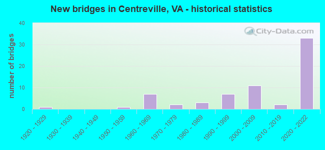
- New bridges - historical statistics
- 11920-1929
- 11950-1959
- 71960-1969
- 21970-1979
- 31980-1989
- 71990-1999
- 112000-2009
- 22010-2019
- 332020-2022


- Bridge Condition - Deck
- 40.0%Excellent
- 4.0%Very good
- 40.0%Good
- 12.0%Satisfactory
- 4.0%Poor

- Bridge Condition - Superstructure
- 40.0%Excellent
- 4.0%Very good
- 40.0%Good
- 12.0%Satisfactory
- 4.0%Poor

- Bridge Condition - Substructure
- 40.0%Excellent
- 44.0%Good
- 8.0%Satisfactory
- 8.0%Fair

- Bridge Condition - Channel
- 5.0%Very good
- 35.0%Good
- 30.0%Satisfactory
- 30.0%Fair

- Bridge Condition - Culverts
- 9.1%Very good
- 45.5%Good
- 45.5%Satisfactory
Find on map >> Show street view
Structure Number: 536, Location: 2.20 FR 250 / 3.20 TO 616 (Lat: 38.014753, Lng: -78.391922), Route carried "on" structure: Interstate 64, Year Built: 1969, Status: Open, Structure Length: 10.30m (33.79ft), Average Daily Traffic: 18,235 (year 2020), Truck Traffic: 11%, Average Future Daily Traffic: 25,529 (year 2040), Design Load: HS 20, Features Intersected: RTE 22 & BBX. RAILWAY
Minimum Vertical Clearance: 30+ m (98+ ft), Kilometerpoint: 203.844, Lanes on structure: 2, Lanes under structure: 2, Base Highway Network: Yes, Owner: State Highway Agency, Approaching Roadway Width: 11.3m (37.1ft), Skew: 4 degrees, Material/Design: Steel, Design/Construction: Stringer/Multi-beam, Number Of Spans In Main Unit: 5, Length of Maximum Span: 22.9m (75.1ft), Curb or Sidewalk Widths: Left: 0.2m (0.7ft), Right: 0.2m (0.7ft), Curb-To-Curb Width: 12.4m (40.7ft), Out-to-Out Width: 13.4m (44.0ft)
Condition: Deck: Satisfactory, Superstructure: Satisfactory, Substructure: Satisfactory, Operating Rating: 65.3 metric tons, Method Used To Determine Operating Rating: Load and Resistance Factor (LRFR), Inventory Rating: 49.9 metric tons, Method Used To Determine Inventory Rating: Load and Resistance Factor (LRFR), Structural Evaluation: Equal to present minimum criteria, Deck Geometry: Better than present minimum criteria, Underclear: Somewhat better than minimum adequacy, Approach Roadway Alignment: Equal to present desirable criteria, Designated Inspection Frequency: Every 24 months, Inspection Date: June 2021, Deck Structure Type: Concrete Cast-file-Place, Wearing Surface/Protective System: Wearing Surface: Epoxy Overlay
Find on map >> Show street view
Structure Number: 537, Location: 1.60 TO F729 - 1.55 7BUS (Lat: 39.161450, Lng: -77.977272), Route carried "on" structure: Bypass State highway 7, Year Built: 1975, Status: Open, Structure Length: 5.49m (18.01ft), Average Daily Traffic: 9,773 (year 2020), Truck Traffic: 6%, Average Future Daily Traffic: 13,684 (year 2040), Design Load: HS 20+Mod, Features Intersected: ROUTE 340, Facility Carried by Structure: HARRY BYRD HWY-WBL
Minimum Vertical Clearance: 30+ m (98+ ft), Kilometerpoint: 17.467, Lanes on structure: 2, Lanes under structure: 4, Base Highway Network: Yes, Owner: State Highway Agency, Approaching Roadway Width: 7.3m (24.0ft), Material/Design: Steel, Design/Construction: Stringer/Multi-beam, Number Of Spans In Main Unit: 2, Length of Maximum Span: 27.4m (89.9ft), Curb-To-Curb Width: 11.0m (36.1ft), Out-to-Out Width: 12.2m (40.0ft)
Condition: Deck: Satisfactory, Superstructure: Satisfactory, Substructure: Satisfactory, Operating Rating: 73.5 metric tons, Method Used To Determine Operating Rating: Load and Resistance Factor (LRFR), Inventory Rating: 57.2 metric tons, Method Used To Determine Inventory Rating: Load and Resistance Factor (LRFR), Structural Evaluation: Equal to present minimum criteria, Deck Geometry: Equal to present minimum criteria, Underclear: Equal to present minimum criteria, Approach Roadway Alignment: Equal to present desirable criteria, Designated Inspection Frequency: Every 24 months, Inspection Date: September 2020, Deck Structure Type: Concrete Cast-file-Place, Wearing Surface/Protective System: Wearing Surface: Epoxy Overlay
Find on map >> Show street view
Structure Number: 6263, Location: 00.30FR657/01.27TO662 (Lat: 38.852264, Lng: -77.432767), Route carried "on" structure: State highway 28, Year Built: 1967, Status: Open, Structure Length: 1.31m (4.30ft), Average Daily Traffic: 82,614 (year 2020), Truck Traffic: 3%, Average Future Daily Traffic: 115,660 (year 2040), Design Load: HS 20, Features Intersected: BIG ROCKY RUN, Facility Carried by Structure: SULLY ROAD
Minimum Vertical Clearance: 30+ m (98+ ft), Kilometerpoint: 50.281, Lanes on structure: 8, Base Highway Network: Yes, Owner: State Highway Agency, Approaching Roadway Width: 35.4m (116.1ft), Skew: 1 degrees, Material/Design: Concrete, Design/Construction: Culvert, Number Of Spans In Main Unit: 4, Length of Maximum Span: 3.0m (9.8ft)
Condition: Channel: Fair, Culverts: Satisfactory, Operating Rating: 89.8 metric tons, Method Used To Determine Operating Rating: Load Factor (LF), Inventory Rating: 89.8 metric tons, Method Used To Determine Inventory Rating: Load Factor (LF), Structural Evaluation: Equal to present minimum criteria, Waterway Adequacy: Equal to present desirable criteria, Approach Roadway Alignment: Equal to present desirable criteria, Length Of Structure Improvement: 30.60m (100.39ft), Designated Inspection Frequency: Every 24 months, Inspection Date: July 2021, Bridge Improvement Cost: $44,000, Roadway Improvement Cost: $75,000, Total Project Cost: $150,000 ( Estimate for 2015)
Find on map >> Show street view
Structure Number: 6271, Location: 00.35FR662/00.25TO7510 (Lat: 38.833244, Lng: -77.463667), Route carried "on" structure: US 29, Year Built: 1926, Status: Open, Structure Length: 1.98m (6.50ft), Average Daily Traffic: 12,816 (year 2020), Truck Traffic: 1%, Average Future Daily Traffic: 17,944 (year 2040), Design Load: HS 20, Features Intersected: CUB RUN, Facility Carried by Structure: LEE HIGHWAY SBL
Minimum Vertical Clearance: 30+ m (98+ ft), Kilometerpoint: 363.119, Lanes on structure: 2, Base Highway Network: Yes, Owner: State Highway Agency, Approaching Roadway Width: 6.4m (21.0ft), Skew: 3 degrees, Material/Design: Concrete, Design/Construction: Stringer/Multi-beam, Number Of Spans In Main Unit: 2, Length of Maximum Span: 10.1m (33.1ft), Curb or Sidewalk Widths: Left: 0.2m (0.7ft), Right: 0.2m (0.7ft), Curb-To-Curb Width: 8.2m (26.9ft), Out-to-Out Width: 9.3m (30.5ft)
Condition: Deck: Satisfactory, Superstructure: Good, Substructure: Fair, Channel: Satisfactory, Operating Rating: 54.4 metric tons, Method Used To Determine Operating Rating: Load and Resistance Factor (LRFR), Inventory Rating: 41.7 metric tons, Method Used To Determine Inventory Rating: Load and Resistance Factor (LRFR), Structural Evaluation: Somewhat better than minimum adequacy, Deck Geometry: High priority of corrective action, Waterway Adequacy: Somewhat better than minimum adequacy, Approach Roadway Alignment: Better than present minimum criteria, Length Of Structure Improvement: 1.98m (6.50ft), Designated Inspection Frequency: Every 24 months, Inspection Date: April 2021, Bridge Improvement Cost: $66,000, Roadway Improvement Cost: $125,000, Total Project Cost: $220,000, Deck Structure Type: Concrete Cast-file-Place
Find on map >> Show street view
Structure Number: 6272, Location: 00.35FR662/00.25TO7510 (Lat: 38.833131, Lng: -77.463539), Route carried "on" structure: US 29, Year Built: 1954, Status: Open, Structure Length: 2.07m (6.79ft), Average Daily Traffic: 12,816 (year 2020), Truck Traffic: 1%, Average Future Daily Traffic: 17,944 (year 2040), Design Load: HS 20, Features Intersected: CUB RUN, Facility Carried by Structure: LEE HIGHWAY NBL
Minimum Vertical Clearance: 30+ m (98+ ft), Kilometerpoint: 363.119, Lanes on structure: 2, Base Highway Network: Yes, Owner: State Highway Agency, Approaching Roadway Width: 11.0m (36.1ft), Skew: 3 degrees, Material/Design: Concrete, Design/Construction: Stringer/Multi-beam, Number Of Spans In Main Unit: 2, Length of Maximum Span: 10.4m (34.1ft), Curb or Sidewalk Widths: Left: 0.2m (0.7ft), Right: 0.2m (0.7ft), Curb-To-Curb Width: 11.8m (38.7ft), Out-to-Out Width: 12.8m (42.0ft)
Condition: Deck: Poor, Superstructure: Poor, Substructure: Fair, Channel: Fair, Operating Rating: 58.1 metric tons, Method Used To Determine Operating Rating: Load Factor (LF), Inventory Rating: 34.7 metric tons, Method Used To Determine Inventory Rating: Load Factor (LF), Structural Evaluation: Meets minimum limits, Deck Geometry: Better than present minimum criteria, Waterway Adequacy: Equal to present minimum criteria, Approach Roadway Alignment: Better than present minimum criteria, Length Of Structure Improvement: 3.05m (10.01ft), Designated Inspection Frequency: Every 12 months, Inspection Date: April 2021, Bridge Improvement Cost: $2,000, Roadway Improvement Cost: $2,000, Total Project Cost: $3,000, Deck Structure Type: Concrete Cast-file-Place, Wearing Surface/Protective System: Wearing Surface: Latex Concrete
Find on map >> Show street view
Structure Number: 6311, Location: 01.60 234 / 01.50 29 (Lat: 38.820478, Lng: -77.465297), Route carried "on" structure: Interstate 66, Year Built: 1961, Year Reconstructed: 1996, Status: Open, Structure Length: 4.08m (13.39ft), Average Daily Traffic: 52,065 (year 2020), Truck Traffic: 7%, Average Future Daily Traffic: 72,891 (year 2040), Design Load: HS 20, Features Intersected: RTE 658__COMPTON ROAD
Minimum Vertical Clearance: 30+ m (98+ ft), Kilometerpoint: 81.898, Lanes on structure: 4, Lanes under structure: 2, Base Highway Network: Yes, Owner: State Highway Agency, Approaching Roadway Width: 22.6m (74.1ft), Skew: 1 degrees, Material/Design: Steel, Design/Construction: Stringer/Multi-beam, Number Of Spans In Main Unit: 3, Length of Maximum Span: 13.4m (44.0ft), Curb-To-Curb Width: 22.6m (74.1ft), Out-to-Out Width: 23.5m (77.1ft)
Condition: Deck: Good, Superstructure: Good, Substructure: Good, Operating Rating: 68.9 metric tons, Method Used To Determine Operating Rating: Load and Resistance Factor (LRFR), Inventory Rating: 53.5 metric tons, Method Used To Determine Inventory Rating: Load and Resistance Factor (LRFR), Structural Evaluation: Better than present minimum criteria, Deck Geometry: Superior to present desirable criteria, Underclear: Meets minimum limits, Approach Roadway Alignment: Equal to present desirable criteria, Length Of Structure Improvement: 4.08m (13.39ft), Designated Inspection Frequency: Every 24 months, Inspection Date: October 2020, Bridge Improvement Cost: $79,000, Roadway Improvement Cost: $125,000, Total Project Cost: $250,000 ( Estimate for 2014), Deck Structure Type: Concrete Cast-file-Place, Wearing Surface/Protective System: Wearing Surface: Monolithic Concrete, Deck Protection: Epoxy Coated Reinforcing
Find on map >> Show street view
Structure Number: 6313, Location: 01.60 234 / 01.50 29 (Lat: 38.820325, Lng: -77.465033), Route carried "on" structure: Interstate 66, Year Built: 1961, Year Reconstructed: 1996, Status: Open, Structure Length: 3.66m (12.01ft), Average Daily Traffic: 73,977 (year 2020), Truck Traffic: 7%, Average Future Daily Traffic: 103,568 (year 2040), Design Load: HS 20, Features Intersected: RTE 658__COMPTON ROAD
Minimum Vertical Clearance: 30+ m (98+ ft), Kilometerpoint: 81.271, Lanes on structure: 4, Lanes under structure: 2, Base Highway Network: Yes, Owner: State Highway Agency, Approaching Roadway Width: 22.6m (74.1ft), Skew: 1 degrees, Material/Design: Steel, Design/Construction: Stringer/Multi-beam, Number Of Spans In Main Unit: 3, Length of Maximum Span: 13.4m (44.0ft), Curb-To-Curb Width: 22.6m (74.1ft), Out-to-Out Width: 23.5m (77.1ft)
Condition: Deck: Good, Superstructure: Satisfactory, Substructure: Good, Operating Rating: 73.5 metric tons, Method Used To Determine Operating Rating: Load and Resistance Factor (LRFR), Inventory Rating: 56.2 metric tons, Method Used To Determine Inventory Rating: Load and Resistance Factor (LRFR), Structural Evaluation: Equal to present minimum criteria, Deck Geometry: Superior to present desirable criteria, Underclear: Meets minimum limits, Approach Roadway Alignment: Equal to present desirable criteria, Designated Inspection Frequency: Every 24 months, Inspection Date: October 2020, Bridge Improvement Cost: $240,000, Roadway Improvement Cost: $10,000, Total Project Cost: $260,000 ( Estimate for 2014), Deck Structure Type: Concrete Cast-file-Place, Wearing Surface/Protective System: Wearing Surface: Monolithic Concrete, Deck Protection: Epoxy Coated Reinforcing
Find on map >> Show street view
Structure Number: 6707, Location: 00.04FR7354/00.09TO7320 (Lat: 38.848494, Lng: -77.438961), Route carried "on" structure: County highway 620, Year Built: 1976, Status: Open, Structure Length: 1.34m (4.40ft), Average Daily Traffic: 12,341 (year 2020), Truck Traffic: 2%, Average Future Daily Traffic: 17,277 (year 2040), Design Load: HS 20, Features Intersected: BIG ROCKY RUN, Facility Carried by Structure: BRADDOCK ROAD
Minimum Vertical Clearance: 30+ m (98+ ft), Kilometerpoint: 6.890, Lanes on structure: 2, Owner: State Highway Agency, Approaching Roadway Width: 13.4m (44.0ft), Skew: 1 degrees, Material/Design: Concrete, Design/Construction: Culvert, Number Of Spans In Main Unit: 4, Length of Maximum Span: 3.4m (11.2ft)
Condition: Channel: Satisfactory, Culverts: Satisfactory, Operating Rating: 73.5 metric tons, Method Used To Determine Operating Rating: Load Factor (LF), Inventory Rating: 43.5 metric tons, Method Used To Determine Inventory Rating: Load Factor (LF), Structural Evaluation: Equal to present minimum criteria, Waterway Adequacy: Somewhat better than minimum adequacy, Approach Roadway Alignment: Equal to present desirable criteria, Length Of Structure Improvement: 0.30m (0.98ft), Designated Inspection Frequency: Every 24 months, Inspection Date: October 2020, Bridge Improvement Cost: $1,000, Roadway Improvement Cost: $1,000, Total Project Cost: $3,000 ( Estimate for 2016)
Find on map >> Show street view
Structure Number: 671, Location: 00.40FR659/01.35TO28 (Lat: 38.829633, Lng: -77.419019), Route carried "on" structure: County highway 7783, Year Built: 1990, Status: Open, Structure Length: 5.09m (16.70ft), Average Daily Traffic: 10,148 (year 2020), Truck Traffic: 2%, Average Future Daily Traffic: 14,209 (year 2040), Design Load: HS 20, Features Intersected: LITTLE ROCKY RUN, Facility Carried by Structure: NEW BRADDCK RD WBL
Minimum Vertical Clearance: 30+ m (98+ ft), Kilometerpoint: 1.593, Lanes on structure: 2, Owner: State Highway Agency, Approaching Roadway Width: 7.6m (24.9ft), Skew: 1 degrees, Material/Design: Steel continuous, Design/Construction: Stringer/Multi-beam, Number Of Spans In Main Unit: 2, Length of Maximum Span: 25.3m (83.0ft), Curb or Sidewalk Widths: Left: 1.5m (4.9ft), Right: 0.0m, Curb-To-Curb Width: 8.2m (26.9ft), Out-to-Out Width: 10.9m (35.8ft)
Condition: Deck: Good, Superstructure: Good, Substructure: Good, Channel: Good, Operating Rating: 68.0 metric tons, Method Used To Determine Operating Rating: Load and Resistance Factor (LRFR), Inventory Rating: 52.6 metric tons, Method Used To Determine Inventory Rating: Load and Resistance Factor (LRFR), Structural Evaluation: Better than present minimum criteria, Deck Geometry: High priority of corrective action, Waterway Adequacy: Equal to present desirable criteria, Approach Roadway Alignment: Superior to present desirable criteria, Length Of Structure Improvement: 5.09m (16.70ft), Designated Inspection Frequency: Every 24 months, Inspection Date: November 2020, Bridge Improvement Cost: $350,000, Roadway Improvement Cost: $50,000, Total Project Cost: $410,000 ( Estimate for 2014), Deck Structure Type: Concrete Cast-file-Place, Wearing Surface/Protective System: Wearing Surface: Monolithic Concrete, Deck Protection: Epoxy Coated Reinforcing
Find on map >> Show street view
Structure Number: 6711, Location: 01.00FR28/00.30T0659 (Lat: 38.829483, Lng: -77.419033), Route carried "on" structure: County highway 7783, Year Built: 1990, Status: Open, Structure Length: 5.09m (16.70ft), Average Daily Traffic: 10,148 (year 2020), Truck Traffic: 2%, Average Future Daily Traffic: 14,209 (year 2040), Design Load: HS 20, Features Intersected: LITTLE ROCKY RUN, Facility Carried by Structure: NEW BRADDCK RD EBL
Minimum Vertical Clearance: 30+ m (98+ ft), Kilometerpoint: 1.593, Lanes on structure: 2, Owner: State Highway Agency, Approaching Roadway Width: 8.5m (27.9ft), Skew: 1 degrees, Material/Design: Steel continuous, Design/Construction: Stringer/Multi-beam, Number Of Spans In Main Unit: 2, Length of Maximum Span: 25.3m (83.0ft), Curb or Sidewalk Widths: Left: 0.0m, Right: 2.4m (7.9ft), Curb-To-Curb Width: 8.4m (27.6ft), Out-to-Out Width: 12.1m (39.7ft)
Condition: Deck: Good, Superstructure: Good, Substructure: Good, Channel: Good, Operating Rating: 59.9 metric tons, Method Used To Determine Operating Rating: Load and Resistance Factor (LRFR), Inventory Rating: 46.3 metric tons, Method Used To Determine Inventory Rating: Load and Resistance Factor (LRFR), Structural Evaluation: Better than present minimum criteria, Deck Geometry: High priority of corrective action, Waterway Adequacy: Equal to present desirable criteria, Approach Roadway Alignment: Superior to present desirable criteria, Length Of Structure Improvement: 5.09m (16.70ft), Designated Inspection Frequency: Every 24 months, Inspection Date: November 2020, Bridge Improvement Cost: $350,000, Roadway Improvement Cost: $50,000, Total Project Cost: $410,000 ( Estimate for 2014), Deck Structure Type: Concrete Cast-file-Place, Wearing Surface/Protective System: Wearing Surface: Monolithic Concrete, Deck Protection: Epoxy Coated Reinforcing
Find on map >> Show street view
Structure Number: 6715, Location: 00.10FR654/01.00TO28 (Lat: 38.830233, Lng: -77.413383), Route carried "on" structure: County highway 7783, Year Built: 1990, Status: Open, Structure Length: 0.94m (3.08ft), Average Daily Traffic: 20,297 (year 2020), Truck Traffic: 2%, Average Future Daily Traffic: 28,416 (year 2040), Design Load: HS 20, Features Intersected: BR. OF LITTLE ROCKY RUN, Facility Carried by Structure: NEW BRADDOCK ROAD
Minimum Vertical Clearance: 30+ m (98+ ft), Kilometerpoint: 2.027, Lanes on structure: 6, Owner: State Highway Agency, Approaching Roadway Width: 22.3m (73.2ft), Skew: 3 degrees, Material/Design: Concrete, Design/Construction: Culvert, Number Of Spans In Main Unit: 3, Length of Maximum Span: 2.7m (8.9ft)
Condition: Channel: Fair, Culverts: Satisfactory, Operating Rating: 67.1 metric tons, Method Used To Determine Operating Rating: Field evaluation and documented engineering judgment, Inventory Rating: 39.9 metric tons, Method Used To Determine Inventory Rating: Field evaluation and documented engineering judgment, Structural Evaluation: Equal to present minimum criteria, Waterway Adequacy: Better than present minimum criteria, Approach Roadway Alignment: Equal to present desirable criteria, Length Of Structure Improvement: 12.80m (41.99ft), Designated Inspection Frequency: Every 24 months, Inspection Date: March 2021, Bridge Improvement Cost: $89,000, Roadway Improvement Cost: $160,000, Total Project Cost: $250,000 ( Estimate for 2015)
Find on map >> Show street view
Structure Number: 6808, Location: 00.40FR.859/01.56TO621 (Lat: 38.821028, Lng: -77.465583), Route carried "on" structure: County highway 658, Year Built: 1961, Status: Open, Structure Length: 3.72m (12.20ft), Average Daily Traffic: 1,868 (year 2020), Truck Traffic: 3%, Average Future Daily Traffic: 2,364 (year 2040), Design Load: HS 20, Features Intersected: CUB RUN, Facility Carried by Structure: COMPTON ROAD
Minimum Vertical Clearance: 30+ m (98+ ft), Kilometerpoint: 2.570, Lanes on structure: 2, Owner: State Highway Agency, Approaching Roadway Width: 7.3m (24.0ft), Skew: 1 degrees, Material/Design: Steel, Design/Construction: Stringer/Multi-beam, Number Of Spans In Main Unit: 2, Length of Maximum Span: 18.6m (61.0ft), Curb-To-Curb Width: 8.5m (27.9ft), Out-to-Out Width: 9.1m (29.9ft)
Condition: Deck: Good, Superstructure: Good, Substructure: Good, Channel: Fair, Operating Rating: 89.8 metric tons, Method Used To Determine Operating Rating: Load and Resistance Factor (LRFR), Inventory Rating: 69.9 metric tons, Method Used To Determine Inventory Rating: Load and Resistance Factor (LRFR), Structural Evaluation: Better than present minimum criteria, Deck Geometry: Somewhat better than minimum adequacy, Waterway Adequacy: Meets minimum limits, Approach Roadway Alignment: Better than present minimum criteria, Length Of Structure Improvement: 3.72m (12.20ft), Designated Inspection Frequency: Every 24 months, Inspection Date: November 2021, Bridge Improvement Cost: $50,000, Roadway Improvement Cost: $50,000, Total Project Cost: $110,000, Deck Structure Type: Concrete Cast-file-Place, Wearing Surface/Protective System: Wearing Surface: Monolithic Concrete, Deck Protection: Epoxy Coated Reinforcing
Find on map >> Show street view
Structure Number: 7094, Location: 0.40FR7345 0.08TO7005 (Lat: 38.848475, Lng: -77.448072), Route carried "on" structure: County highway 7346, Year Built: 1986, Status: Open, Structure Length: 1.95m (6.40ft), Average Daily Traffic: 1,936 (year 2020), Truck Traffic: 3%, Average Future Daily Traffic: 2,521 (year 2040), Design Load: HS 20+Mod, Features Intersected: BIG ROCKY RUN, Facility Carried by Structure: AUBREY PATENT DR.
Minimum Vertical Clearance: 30+ m (98+ ft), Kilometerpoint: 1.863, Lanes on structure: 2, Owner: State Highway Agency, Approaching Roadway Width: 9.1m (29.9ft), Material/Design: Concrete, Design/Construction: Culvert, Number Of Spans In Main Unit: 6, Length of Maximum Span: 3.0m (9.8ft)
Condition: Channel: Fair, Culverts: Satisfactory, Operating Rating: 73.5 metric tons, Method Used To Determine Operating Rating: Load Factor (LF), Inventory Rating: 43.5 metric tons, Method Used To Determine Inventory Rating: Load Factor (LF), Structural Evaluation: Equal to present minimum criteria, Waterway Adequacy: Better than present minimum criteria, Approach Roadway Alignment: Equal to present desirable criteria, Length Of Structure Improvement: 10.97m (35.99ft), Designated Inspection Frequency: Every 24 months, Inspection Date: Febuary 2021, Bridge Improvement Cost: $55,000, Roadway Improvement Cost: $175,000, Total Project Cost: $600,000 ( Estimate for 2015)
Find on map >> Show street view
Structure Number: 23521, Location: 00.25 6755 / 00.30 8461 (Lat: 38.872272, Lng: -77.452844), Route carried "on" structure: Business County highway 8460, Year Built: 1989, Status: Open, Structure Length: 1.31m (4.30ft), Average Daily Traffic: 15,318 (year 2020), Truck Traffic: 4%, Average Future Daily Traffic: 21,445 (year 2040), Design Load: HS 20, Features Intersected: FLATLICK BRANCH, Facility Carried by Structure: STONECROFT BLVD.
Minimum Vertical Clearance: 30+ m (98+ ft), Kilometerpoint: 0.000, Lanes on structure: 4, Owner: State Highway Agency, Approaching Roadway Width: 16.5m (54.1ft), Material/Design: Concrete, Design/Construction: Culvert, Number Of Spans In Main Unit: 4, Length of Maximum Span: 3.0m (9.8ft)
Condition: Channel: Fair, Culverts: Satisfactory, Operating Rating: 89.8 metric tons, Method Used To Determine Operating Rating: Load Factor (LF), Inventory Rating: 59.9 metric tons, Method Used To Determine Inventory Rating: Load Factor (LF), Structural Evaluation: Equal to present minimum criteria, Approach Roadway Alignment: Equal to present desirable criteria, Length Of Structure Improvement: 3.54m (11.61ft), Designated Inspection Frequency: Every 24 months, Inspection Date: March 2020, Bridge Improvement Cost: $35,000, Roadway Improvement Cost: $50,000, Total Project Cost: $150,000
Find on map >> Show street view
Structure Number: 2401, Location: 01.15FR645/00.80TO659 (Lat: 38.796594, Lng: -77.409531), Route carried "on" structure: County highway 658, Year Built: 1994, Status: Open, Structure Length: 0.85m (2.79ft), Average Daily Traffic: 1,208 (year 2020), Truck Traffic: 2%, Average Future Daily Traffic: 1,295 (year 2040), Design Load: HS 20, Features Intersected: JOHNNY MOORE CREEK, Facility Carried by Structure: COMPTON ROAD
Minimum Vertical Clearance: 30+ m (98+ ft), Kilometerpoint: 8.930, Lanes on structure: 2, Owner: State Highway Agency, Approaching Roadway Width: 7.3m (24.0ft), Skew: 2 degrees, Material/Design: Concrete, Design/Construction: Culvert, Number Of Spans In Main Unit: 2, Length of Maximum Span: 4.3m (14.1ft), Curb-To-Curb Width: 10.7m (35.1ft), Out-to-Out Width: 11.3m (37.1ft)
Condition: Channel: Satisfactory, Culverts: Good, Operating Rating: 66.2 metric tons, Method Used To Determine Operating Rating: Load Factor (LF), Inventory Rating: 39.0 metric tons, Method Used To Determine Inventory Rating: Load Factor (LF), Structural Evaluation: Better than present minimum criteria, Deck Geometry: Equal to present minimum criteria, Waterway Adequacy: Better than present minimum criteria, Approach Roadway Alignment: Equal to present minimum criteria, Length Of Structure Improvement: 0.30m (0.98ft), Designated Inspection Frequency: Every 24 months, Inspection Date: October 2020, Bridge Improvement Cost: $1,000, Roadway Improvement Cost: $1,000, Total Project Cost: $3,000
Find on map >> Show street view
Structure Number: 24993, Location: 02.00FR234/02.26TO29 (Lat: 38.815094, Lng: -77.477889), Route carried "on" structure: Interstate 66, Year Built: 1996, Status: Open, Structure Length: 8.84m (29.00ft), Average Daily Traffic: 52,065 (year 2020), Truck Traffic: 7%, Average Future Daily Traffic: 72,891 (year 2040), Design Load: HS 20, Features Intersected: CUB RUN
Minimum Vertical Clearance: 30+ m (98+ ft), Kilometerpoint: 80.675, Lanes on structure: 4, Base Highway Network: Yes, Owner: State Highway Agency, Approaching Roadway Width: 21.9m (71.9ft), Material/Design: Steel continuous, Design/Construction: Stringer/Multi-beam, Number Of Spans In Main Unit: 3, Length of Maximum Span: 36.6m (120.1ft), Curb-To-Curb Width: 26.2m (86.0ft), Out-to-Out Width: 27.3m (89.6ft)
Condition: Deck: Good, Superstructure: Good, Substructure: Good, Channel: Good, Operating Rating: 57.2 metric tons, Method Used To Determine Operating Rating: Load and Resistance Factor (LRFR), Inventory Rating: 44.5 metric tons, Method Used To Determine Inventory Rating: Load and Resistance Factor (LRFR), Structural Evaluation: Better than present minimum criteria, Deck Geometry: Superior to present desirable criteria, Waterway Adequacy: Equal to present desirable criteria, Approach Roadway Alignment: Equal to present desirable criteria, Length Of Structure Improvement: 8.84m (29.00ft), Designated Inspection Frequency: Every 24 months, Inspection Date: July 2021, Bridge Improvement Cost: $55,000, Roadway Improvement Cost: $99,000, Total Project Cost: $175,000, Deck Structure Type: Concrete Cast-file-Place, Wearing Surface/Protective System: Wearing Surface: Monolithic Concrete, Deck Protection: Epoxy Coated Reinforcing
Find on map >> Show street view
Structure Number: 25501, Location: 00.17FR7988/00.10TO29 (Lat: 38.841639, Lng: -77.404469), Route carried "on" structure: County highway 645, Year Built: 1998, Status: Open, Structure Length: 1.62m (5.31ft), Average Daily Traffic: 13,375 (year 2020), Average Future Daily Traffic: 18,725 (year 2040), Design Load: HS 20, Features Intersected: LITTLE ROCKY RUN, Facility Carried by Structure: STRINGFELLOW RD
Minimum Vertical Clearance: 30+ m (98+ ft), Kilometerpoint: 0.129, Lanes on structure: 4, Owner: State Highway Agency, Approaching Roadway Width: 16.5m (54.1ft), Skew: 1 degrees, Material/Design: Concrete, Design/Construction: Culvert, Number Of Spans In Main Unit: 4, Length of Maximum Span: 3.7m (12.1ft), Curb or Sidewalk Widths: Left: 2.4m (7.9ft), Right: 1.5m (4.9ft)
Condition: Channel: Satisfactory, Culverts: Good, Operating Rating: 78.9 metric tons, Method Used To Determine Operating Rating: Load Factor (LF), Inventory Rating: 47.2 metric tons, Method Used To Determine Inventory Rating: Load Factor (LF), Structural Evaluation: Better than present minimum criteria, Waterway Adequacy: Better than present minimum criteria, Approach Roadway Alignment: Equal to present desirable criteria, Length Of Structure Improvement: 0.30m (0.98ft), Designated Inspection Frequency: Every 24 months, Inspection Date: August 2020, Bridge Improvement Cost: $1,000, Roadway Improvement Cost: $1,000, Total Project Cost: $3,000
Find on map >> Show street view
Structure Number: 26288, Location: 00.40FR662/00.90TO28 (Lat: 38.836356, Lng: -77.449956), Route carried "on" structure: US 29, Year Built: 1999, Status: Open, Structure Length: 4.36m (14.30ft), Average Daily Traffic: 25,633 (year 2020), Truck Traffic: 1%, Average Future Daily Traffic: 35,886 (year 2040), Design Load: HS 20, Features Intersected: BIG ROCKY RUN, Facility Carried by Structure: LEE HIGHWAY
Minimum Vertical Clearance: 30+ m (98+ ft), Kilometerpoint: 364.342, Lanes on structure: 7, Base Highway Network: Yes, Owner: State Highway Agency, Approaching Roadway Width: 31.1m (102.0ft), Skew: 20 degrees, Material/Design: Steel continuous, Design/Construction: Stringer/Multi-beam, Number Of Spans In Main Unit: 2, Length of Maximum Span: 25.3m (83.0ft), Curb or Sidewalk Widths: Left: 3.8m (12.5ft), Right: 3.8m (12.5ft), Curb-To-Curb Width: 31.3m (102.7ft), Out-to-Out Width: 43.2m (141.7ft)
Condition: Deck: Good, Superstructure: Good, Substructure: Good, Channel: Satisfactory, Operating Rating: 51.1 metric tons, Method Used To Determine Operating Rating: Load and Resistance Factor (LRFR), Inventory Rating: 39.4 metric tons, Method Used To Determine Inventory Rating: Load and Resistance Factor (LRFR), Structural Evaluation: Better than present minimum criteria, Deck Geometry: Better than present minimum criteria, Waterway Adequacy: Better than present minimum criteria, Approach Roadway Alignment: Equal to present desirable criteria, Length Of Structure Improvement: 4.36m (14.30ft), Designated Inspection Frequency: Every 24 months, Inspection Date: August 2020, Bridge Improvement Cost: $31,000, Roadway Improvement Cost: $69,000, Total Project Cost: $112,000, Deck Structure Type: Concrete Cast-file-Place, Wearing Surface/Protective System: Deck Protection: Epoxy Coated Reinforcing
Find on map >> Show street view
Structure Number: 26389, Location: 00.33FR858/00.55TO66 (Lat: 38.838567, Lng: -77.431992), Route carried "on" structure: US 29, Year Built: 2000, Status: Open, Structure Length: 6.52m (21.39ft), Average Daily Traffic: 33,226 (year 2020), Truck Traffic: 1%, Average Future Daily Traffic: 36,115 (year 2040), Design Load: HS 20, Features Intersected: ROUTE 28 - SULLY ROAD, Facility Carried by Structure: LEE HIGHWAY
Minimum Vertical Clearance: 30+ m (98+ ft), Kilometerpoint: 365.887, Lanes on structure: 7, Lanes under structure: 8, Base Highway Network: Yes, Owner: State Highway Agency, Approaching Roadway Width: 40.8m (133.9ft), Skew: 21 degrees, Material/Design: Steel continuous, Design/Construction: Stringer/Multi-beam, Number Of Spans In Main Unit: 2, Length of Maximum Span: 33.8m (110.9ft), Curb or Sidewalk Widths: Left: 1.5m (4.9ft), Right: 2.4m (7.9ft), Curb-To-Curb Width: 42.7m (140.1ft), Out-to-Out Width: 48.1m (157.8ft)
Condition: Deck: Good, Superstructure: Good, Substructure: Good, Operating Rating: 58.6 metric tons, Method Used To Determine Operating Rating: Load and Resistance Factor (LRFR), Inventory Rating: 45.3 metric tons, Method Used To Determine Inventory Rating: Load and Resistance Factor (LRFR), Structural Evaluation: Better than present minimum criteria, Deck Geometry: Superior to present desirable criteria, Underclear: Equal to present minimum criteria, Approach Roadway Alignment: Equal to present desirable criteria, Length Of Structure Improvement: 6.52m (21.39ft), Designated Inspection Frequency: Every 24 months, Inspection Date: July 2021, Bridge Improvement Cost: $400,000, Roadway Improvement Cost: $40,000, Total Project Cost: $460,000 ( Estimate for 2015), Deck Structure Type: Concrete Cast-file-Place, Wearing Surface/Protective System: Deck Protection: Epoxy Coated Reinforcing
Find on map >> Show street view
Structure Number: 28099, Location: 0.20FR STONCRFT/0.55TO657 (Lat: 38.872672, Lng: -77.445692), Route carried "on" structure: County highway 662, Year Built: 2005, Status: Open, Structure Length: 9.14m (29.99ft), Average Daily Traffic: 28,425 (year 2020), Truck Traffic: 2%, Average Future Daily Traffic: 39,795 (year 2040), Design Load: HS 20, Features Intersected: RTE.28 SULLY RD., Facility Carried by Structure: Westfields Blvd.
Minimum Vertical Clearance: 30+ m (98+ ft), Kilometerpoint: 0.177, Lanes on structure: 6, Lanes under structure: 10, Owner: State Highway Agency, Approaching Roadway Width: 34.7m (113.8ft), Skew: 21 degrees, Material/Design: Steel continuous, Design/Construction: Stringer/Multi-beam, Number Of Spans In Main Unit: 2, Length of Maximum Span: 44.8m (147.0ft), Curb or Sidewalk Widths: Left: 3.0m (9.8ft), Right: 3.0m (9.8ft), Curb-To-Curb Width: 28.7m (94.2ft), Out-to-Out Width: 35.8m (117.5ft)
Condition: Deck: Good, Superstructure: Good, Substructure: Good, Operating Rating: 73.5 metric tons, Method Used To Determine Operating Rating: Load and Resistance Factor (LRFR), Inventory Rating: 57.2 metric tons, Method Used To Determine Inventory Rating: Load and Resistance Factor (LRFR), Structural Evaluation: Better than present minimum criteria, Deck Geometry: Superior to present desirable criteria, Underclear: Equal to present minimum criteria, Approach Roadway Alignment: Equal to present desirable criteria, Length Of Structure Improvement: 9.14m (29.99ft), Designated Inspection Frequency: Every 24 months, Inspection Date: September 2021, Bridge Improvement Cost: $87,000, Roadway Improvement Cost: $144,000, Total Project Cost: $300,000, Deck Structure Type: Concrete Cast-file-Place, Wearing Surface/Protective System: Wearing Surface: Monolithic Concrete, Deck Protection: Epoxy Coated Reinforcing
Find on map >> Show street view
Structure Number: 28515, Location: 00.10FR645/00.30TO29 (Lat: 38.848939, Lng: -77.407381), Route carried "on" structure: County highway 8285, Year Built: 2005, Status: Open, Structure Length: 1.22m (4.00ft), Average Daily Traffic: 101 (year 2000), Average Future Daily Traffic: 121 (year 2040), Design Load: HS 20, Features Intersected: TRIB.OF LITTLE ROCKY RUN, Facility Carried by Structure: CENTREVILLE FARMS
Minimum Vertical Clearance: 30+ m (98+ ft), Kilometerpoint: 0.161, Lanes on structure: 6, Owner: State Highway Agency, Approaching Roadway Width: 7.9m (25.9ft), Skew: 2 degrees, Material/Design: Concrete, Design/Construction: Culvert, Number Of Spans In Main Unit: 4, Length of Maximum Span: 2.4m (7.9ft)
Condition: Channel: Good, Culverts: Good, Operating Rating: 89.8 metric tons, Method Used To Determine Operating Rating: Load Factor (LF), Inventory Rating: 59.0 metric tons, Method Used To Determine Inventory Rating: Load Factor (LF), Structural Evaluation: Better than present minimum criteria, Waterway Adequacy: Better than present minimum criteria, Approach Roadway Alignment: Equal to present desirable criteria, Length Of Structure Improvement: 19.51m (64.01ft), Designated Inspection Frequency: Every 24 months, Inspection Date: March 2021, Bridge Improvement Cost: $76,000, Roadway Improvement Cost: $125,000, Total Project Cost: $250,000 ( Estimate for 2015)
Find on map >> Show street view
Structure Number: 28517, Location: 00.10FR29/00.28TO LELAND (Lat: 38.840950, Lng: -77.411533), Route carried "on" structure: County highway 8285, Year Built: 2005, Status: Open, Structure Length: 1.62m (5.31ft), Average Daily Traffic: 6,513 (year 2020), Truck Traffic: 2%, Average Future Daily Traffic: 9,118 (year 2040), Design Load: HS 20+Mod, Features Intersected: TRIB.OF WILLOW SPRINGS, Facility Carried by Structure: CENTREVILLE FARMS
Minimum Vertical Clearance: 30+ m (98+ ft), Kilometerpoint: 0.644, Lanes on structure: 5, Owner: State Highway Agency, Approaching Roadway Width: 7.3m (24.0ft), Material/Design: Concrete, Design/Construction: Culvert, Number Of Spans In Main Unit: 4, Length of Maximum Span: 3.7m (12.1ft)
Condition: Channel: Satisfactory, Culverts: Good, Operating Rating: 65.3 metric tons, Method Used To Determine Operating Rating: Load Factor (LF), Inventory Rating: 39.0 metric tons, Method Used To Determine Inventory Rating: Load Factor (LF), Structural Evaluation: Better than present minimum criteria, Waterway Adequacy: Better than present minimum criteria, Approach Roadway Alignment: Equal to present desirable criteria, Length Of Structure Improvement: 17.07m (56.00ft), Designated Inspection Frequency: Every 24 months, Inspection Date: March 2021, Bridge Improvement Cost: $55,000, Roadway Improvement Cost: $89,000, Total Project Cost: $175,000
Find on map >> Show street view
Structure Number: 28639, Location: 0.20From0000/0.25To10099 (Lat: 38.844758, Lng: -77.409928), Route carried "on" structure: County highway 7773, Year Built: 2005, Status: Open, Structure Length: 0.79m (2.59ft), Average Daily Traffic: 1,746 (year 2020), Truck Traffic: 4%, Average Future Daily Traffic: 1,921 (year 2040), Design Load: HS 20, Features Intersected: Little Rocky Willow Run, Facility Carried by Structure: Leland Road
Minimum Vertical Clearance: 30+ m (98+ ft), Kilometerpoint: 0.000, Lanes on structure: 2, Owner: State Highway Agency, Approaching Roadway Width: 11.0m (36.1ft), Material/Design: Concrete, Design/Construction: Culvert, Number Of Spans In Main Unit: 3, Length of Maximum Span: 2.4m (7.9ft), Curb or Sidewalk Widths: Left: 1.5m (4.9ft), Right: 1.5m (4.9ft)
Condition: Channel: Good, Culverts: Good, Operating Rating: 86.2 metric tons, Method Used To Determine Operating Rating: Load Factor (LF), Inventory Rating: 51.7 metric tons, Method Used To Determine Inventory Rating: Load Factor (LF), Structural Evaluation: Better than present minimum criteria, Waterway Adequacy: Better than present minimum criteria, Approach Roadway Alignment: Better than present minimum criteria, Length Of Structure Improvement: 8.50m (27.89ft), Designated Inspection Frequency: Every 24 months, Inspection Date: December 2021, Bridge Improvement Cost: $15,000, Roadway Improvement Cost: $15,000, Total Project Cost: $50,000 ( Estimate for 2015)
Find on map >> Show street view
Structure Number: 30109, Location: 0.53fr645 0.53to659 (Lat: 38.815250, Lng: -77.405361), Route carried "on" structure: Bypass County highway 3546, Year Built: 2014, Status: Open, Structure Length: 0.82m (2.69ft), Average Daily Traffic: 1,375 (year 2015), Average Future Daily Traffic: 1,547 (year 2040), Design Load: HS 20, Features Intersected: JOHNNY MOORE CREEK, Facility Carried by Structure: TWIN LAKE DRIVE
Minimum Vertical Clearance: 30.18m (99.02ft), Kilometerpoint: 0.000, Lanes on structure: 2, Owner: State Highway Agency, Approaching Roadway Width: 9.1m (29.9ft), Material/Design: Prestressed concrete, Design/Construction: Slab, Number Of Spans In Main Unit: 1, Length of Maximum Span: 7.6m (24.9ft), Curb-To-Curb Width: 7.3m (24.0ft), Out-to-Out Width: 9.1m (29.9ft)
Condition: Deck: Very good, Superstructure: Very good, Substructure: Good, Channel: Very good, Operating Rating: 64.4 metric tons, Method Used To Determine Operating Rating: Load and Resistance Factor (LRFR), Inventory Rating: 49.0 metric tons, Method Used To Determine Inventory Rating: Load and Resistance Factor (LRFR), Structural Evaluation: Better than present minimum criteria, Deck Geometry: Meets minimum limits, Waterway Adequacy: Better than present minimum criteria, Approach Roadway Alignment: Equal to present minimum criteria, Designated Inspection Frequency: Every 24 months, Inspection Date: August 2020, Deck Structure Type: Concrete Precast Panels, Wearing Surface/Protective System: Wearing Surface: Bituminous
Find on map >> Show street view
Structure Number: 30235, Location: 0.85fr28 0.5to645 (Lat: 38.838928, Lng: -77.415506), Route carried "on" structure: State highway 29, Year Built: 2015, Status: Open, Structure Length: 4.75m (15.58ft), Average Daily Traffic: 16,613 (year 2020), Truck Traffic: 1%, Average Future Daily Traffic: 23,258 (year 2040), Design Load: HS 20, Features Intersected: LITTLE ROCKY RUN
Minimum Vertical Clearance: 30.18m (99.02ft), Kilometerpoint: 0.000, Lanes on structure: 3, Base Highway Network: Yes, Owner: State Highway Agency, Approaching Roadway Width: 15.2m (49.9ft), Skew: 24 degrees, Material/Design: Prestressed concrete, Design/Construction: Box Beam or Girders - Multiple, Number Of Spans In Main Unit: 2, Length of Maximum Span: 23.2m (76.1ft), Curb or Sidewalk Widths: Left: 4.3m (14.1ft), Right: 2.1m (6.9ft), Curb-To-Curb Width: 12.8m (42.0ft), Out-to-Out Width: 37.8m (124.0ft)
Condition: Deck: Good, Superstructure: Good, Substructure: Good, Channel: Good, Operating Rating: 90.6 metric tons, Method Used To Determine Operating Rating: Load and Resistance Factor (LRFR), Inventory Rating: 80.8 metric tons, Method Used To Determine Inventory Rating: Load and Resistance Factor (LRFR), Structural Evaluation: Better than present minimum criteria, Deck Geometry: Meets minimum limits, Waterway Adequacy: Equal to present desirable criteria, Approach Roadway Alignment: Equal to present desirable criteria, Designated Inspection Frequency: Every 24 months, Inspection Date: January 2021, Deck Structure Type: Concrete Precast Panels, Wearing Surface/Protective System: Wearing Surface: Monolithic Concrete, Deck Protection: Epoxy Coated Reinforcing
Find on map >> Show street view
Structure Number: 30736, Location: 00.07fr29 00.40to wood (Lat: 38.839519, Lng: -77.441175), Route carried "on" structure: County highway 5401, Year Built: 1989, Status: Open, Structure Length: 0.81m (2.66ft), Average Daily Traffic: 11,000 (year 2019), Average Future Daily Traffic: 15,840 (year 2041), Design Load: HS 20, Features Intersected: TRIB. OF BIG ROCK RUN, Facility Carried by Structure: TRINITY PKWY
Minimum Vertical Clearance: 30.18m (99.02ft), Kilometerpoint: 0.000, Lanes on structure: 3, Owner: State Highway Agency, Approaching Roadway Width: 19.2m (63.0ft), Material/Design: Concrete, Design/Construction: Culvert, Number Of Spans In Main Unit: 3, Length of Maximum Span: 2.4m (7.9ft), Curb or Sidewalk Widths: Left: 1.2m (3.9ft), Right: 1.2m (3.9ft)
Condition: Channel: Good, Culverts: Very good, Operating Rating: 89.8 metric tons, Method Used To Determine Operating Rating: Field evaluation and documented engineering judgment, Inventory Rating: 88.9 metric tons, Method Used To Determine Inventory Rating: Field evaluation and documented engineering judgment, Structural Evaluation: Equal to present desirable criteria, Waterway Adequacy: Equal to present minimum criteria, Approach Roadway Alignment: Better than present minimum criteria, Designated Inspection Frequency: Every 24 months, Inspection Date: December 2020
Find on map >> Show street view
Structure Number: 30941, Location: 0.31fr West F 0.69to657 (Lat: 38.868650, Lng: -77.442811), Route carried "on" structure: Alternate County highway 4831, Year Built: 2020, Status: Open, Structure Length: 8.23m (27.00ft), Average Daily Traffic: 200 (year 2020), Average Future Daily Traffic: 800 (year 2040), Design Load: HL 93, Features Intersected: RTE 28/SULLY RD, Facility Carried by Structure: POPLAR TREE ROAD
Minimum Vertical Clearance: 5.74m (18.83ft), Kilometerpoint: 0.000, Lanes on structure: 2, Lanes under structure: 8, Owner: State Highway Agency, Approaching Roadway Width: 15.2m (49.9ft), Skew: 2 degrees, Material/Design: Concrete, Design/Construction: Stringer/Multi-beam, Number Of Spans In Main Unit: 2, Length of Maximum Span: 41.1m (134.8ft), Curb or Sidewalk Widths: Left: 5.2m (17.1ft), Right: 0.0m, Curb-To-Curb Width: 15.2m (49.9ft), Out-to-Out Width: 20.7m (67.9ft)
Condition: Deck: Excellent, Superstructure: Excellent, Substructure: Excellent, Operating Rating: 78.4 metric tons, Method Used To Determine Operating Rating: Load and Resistance Factor (LRFR), Inventory Rating: 61.3 metric tons, Method Used To Determine Inventory Rating: Load and Resistance Factor (LRFR), Structural Evaluation: Superior to present desirable criteria, Deck Geometry: Superior to present desirable criteria, Underclear: Superior to present desirable criteria, Approach Roadway Alignment: Better than present minimum criteria, Designated Inspection Frequency: Every 24 months, Inspection Date: November 2020, Deck Structure Type: Concrete Cast-file-Place, Wearing Surface/Protective System: Wearing Surface: Monolithic Concrete, Deck Protection: Other
Find on map >> Show street view
Structure Number: 30942, Location: 1.36r662 00.01to657 (Lat: 38.851667, Lng: -77.433472), Route carried "on" structure: County highway 620, Year Built: 2020, Status: Open, Structure Length: 5.88m (19.29ft), Average Daily Traffic: 12,341 (year 2020), Truck Traffic: 3%, Average Future Daily Traffic: 17,277 (year 2040), Design Load: HL 93, Features Intersected: 28SB off ramps to 66 WB, Facility Carried by Structure: BRADDOCK ROAD
Minimum Vertical Clearance: 30.18m (99.02ft), Kilometerpoint: 0.000, Lanes on structure: 4, Lanes under structure: 9, Owner: State Highway Agency, Approaching Roadway Width: 29.0m (95.1ft), Material/Design: Prestressed concrete continuous, Design/Construction: Stringer/Multi-beam, Number Of Spans In Main Unit: 2, Length of Maximum Span: 38.4m (126.0ft), Curb or Sidewalk Widths: Left: 4.7m (15.4ft), Right: 0.0m, Curb-To-Curb Width: 29.0m (95.1ft), Out-to-Out Width: 33.1m (108.6ft)
Condition: Deck: Excellent, Superstructure: Excellent, Substructure: Excellent, Operating Rating: 76.2 metric tons, Method Used To Determine Operating Rating: Load and Resistance Factor (LRFR), Inventory Rating: 56.1 metric tons, Method Used To Determine Inventory Rating: Load and Resistance Factor (LRFR), Structural Evaluation: Superior to present desirable criteria, Deck Geometry: Superior to present desirable criteria, Underclear: Superior to present desirable criteria, Approach Roadway Alignment: Equal to present desirable criteria, Designated Inspection Frequency: Every 24 months, Inspection Date: November 2020, Deck Structure Type: Concrete Cast-file-Place, Wearing Surface/Protective System: Wearing Surface: Monolithic Concrete, Deck Protection: Epoxy Coated Reinforcing
Find on map >> Show street view
Structure Number: 3095, Location: .55 FR 28 1.61 TO 50 (Lat: 38.851797, Lng: -77.402864), Route carried "on" structure: Interstate 66, Year Built: 2021, Status: Open, Structure Length: 4.73m (15.52ft), Average Daily Traffic: 78,506 (year 2018), Truck Traffic: 3%, Average Future Daily Traffic: 100,544 (year 2035), Design Load: HL 93, Features Intersected: STRINGFELLOW RD
Minimum Vertical Clearance: 30.18m (99.02ft), Kilometerpoint: 0.000, Lanes on structure: 5, Lanes under structure: 6, Owner: State Highway Agency, Approaching Roadway Width: 26.8m (87.9ft), Number Of Spans In Main Unit: 1, Length of Maximum Span: 47.3m (155.2ft), Curb-To-Curb Width: 26.8m (87.9ft), Out-to-Out Width: 28.0m (91.9ft)
Condition: Deck: Excellent, Superstructure: Excellent, Substructure: Excellent, Operating Rating: 89.8 metric tons, Method Used To Determine Operating Rating: Load and Resistance Factor (LRFR), Inventory Rating: 59.2 metric tons, Method Used To Determine Inventory Rating: Load and Resistance Factor (LRFR), Structural Evaluation: Superior to present desirable criteria, Deck Geometry: Superior to present desirable criteria, Underclear: Somewhat better than minimum adequacy, Approach Roadway Alignment: Equal to present minimum criteria, Designated Inspection Frequency: Every 24 months, Inspection Date: September 2021, Deck Structure Type: Concrete Cast-file-Place, Wearing Surface/Protective System: Wearing Surface: Monolithic Concrete, Deck Protection: Other Coated Reinforcing
Find on map >> Show street view
Structure Number: 31046, Location: .46Frm Rt 29 .42To Rt 657 (Lat: 38.845569, Lng: -77.431242), Route carried "on" structure: Interstate 66, Year Built: 2020, Status: Open, Structure Length: 3.66m (12.01ft), Average Daily Traffic: 62,000 (year 2020), Truck Traffic: 1%, Average Future Daily Traffic: 73,000 (year 2030), Design Load: HL 93, Features Intersected: Rt 28 SB Rmp to 1-66 EB, Facility Carried by Structure: Rt 28 NB
Minimum Vertical Clearance: 30.18m (99.02ft), Kilometerpoint: 0.000, Lanes on structure: 4, Lanes under structure: 1, Owner: State Highway Agency, Approaching Roadway Width: 26.8m (87.9ft), Skew: 2 degrees, Material/Design: Prestressed concrete, Number Of Spans In Main Unit: 1, Length of Maximum Span: 32.0m (105.0ft), Curb-To-Curb Width: 26.8m (87.9ft), Out-to-Out Width: 29.6m (97.1ft)
Condition: Deck: Excellent, Superstructure: Excellent, Substructure: Excellent, Operating Rating: 84.3 metric tons, Method Used To Determine Operating Rating: Load and Resistance Factor (LRFR), Inventory Rating: 60.7 metric tons, Method Used To Determine Inventory Rating: Load and Resistance Factor (LRFR), Structural Evaluation: Superior to present desirable criteria, Deck Geometry: Superior to present desirable criteria, Underclear: Equal to present minimum criteria, Approach Roadway Alignment: Equal to present desirable criteria, Designated Inspection Frequency: Every 24 months, Inspection Date: November 2020, Deck Structure Type: Concrete Cast-file-Place, Wearing Surface/Protective System: Wearing Surface: Monolithic Concrete, Deck Protection: Other
Find on map >> Show street view
Structure Number: 31052, Location: 00.02fr620 00,35to66W (Lat: 38.850917, Lng: -77.433747), Route carried "on" structure: Interstate 66, Year Built: 2020, Status: Open, Structure Length: 4.51m (14.80ft), Average Daily Traffic: 16,000 (year 2021), Average Future Daily Traffic: 28,000 (year 2036), Design Load: HL 93, Features Intersected: ROUTE 28 SB
Minimum Vertical Clearance: 30.18m (99.02ft), Kilometerpoint: 0.000, Lanes on structure: 2, Lanes under structure: 2, Owner: State Highway Agency, Approaching Roadway Width: 12.2m (40.0ft), Skew: 3 degrees, Material/Design: Prestressed concrete, Design/Construction: Stringer/Multi-beam, Number Of Spans In Main Unit: 1, Length of Maximum Span: 43.3m (142.1ft), Curb-To-Curb Width: 13.1m (43.0ft), Out-to-Out Width: 13.7m (44.9ft)
Condition: Deck: Excellent, Superstructure: Excellent, Substructure: Excellent, Operating Rating: 89.8 metric tons, Method Used To Determine Operating Rating: Load and Resistance Factor (LRFR), Inventory Rating: 57.8 metric tons, Method Used To Determine Inventory Rating: Load and Resistance Factor (LRFR), Structural Evaluation: Superior to present desirable criteria, Deck Geometry: Superior to present desirable criteria, Underclear: Equal to present minimum criteria, Approach Roadway Alignment: Equal to present desirable criteria, Designated Inspection Frequency: Every 24 months, Inspection Date: November 2020, Deck Structure Type: Concrete Cast-file-Place, Wearing Surface/Protective System: Wearing Surface: Monolithic Concrete, Deck Protection: Other
Find on map >> Show street view
Structure Number: 31053, Location: 00.30fr66 00.50to29 (Lat: 38.846783, Lng: -77.432708), Route carried "on" structure: State highway 28, Year Built: 2021, Status: Open, Structure Length: 12.31m (40.39ft), Average Daily Traffic: 15,000 (year 2021), Average Future Daily Traffic: 25,000 (year 2035), Design Load: HL 93, Features Intersected: I-66
Minimum Vertical Clearance: 30.18m (99.02ft), Kilometerpoint: 0.000, Lanes on structure: 7, Lanes under structure: 13, Owner: State Highway Agency, Approaching Roadway Width: 12.2m (40.0ft), Material/Design: Prestressed concrete, Design/Construction: Stringer/Multi-beam, Number Of Spans In Main Unit: 4, Length of Maximum Span: 42.4m (139.1ft), Curb-To-Curb Width: 10.4m (34.1ft), Out-to-Out Width: 17.4m (57.1ft)
Condition: Deck: Excellent, Superstructure: Excellent, Substructure: Excellent, Operating Rating: 74.8 metric tons, Method Used To Determine Operating Rating: Load and Resistance Factor (LRFR), Inventory Rating: 57.8 metric tons, Method Used To Determine Inventory Rating: Load and Resistance Factor (LRFR), Structural Evaluation: Superior to present desirable criteria, Deck Geometry: High priority of replacement, Underclear: Equal to present desirable criteria, Approach Roadway Alignment: Better than present minimum criteria, Designated Inspection Frequency: Every 24 months, Inspection Date: October 2021, Deck Structure Type: Concrete Cast-file-Place, Wearing Surface/Protective System: Wearing Surface: Monolithic Concrete, Deck Protection: Other
Find on map >> Show street view
Structure Number: 31055, Location: 00.38fr66EB 00.10to28NB (Lat: 38.846203, Lng: -77.431578), Route carried "on" structure: State highway 28, Year Built: 2020, Status: Open, Structure Length: 17.01m (55.81ft), Average Daily Traffic: 110,967 (year 2018), Truck Traffic: 3%, Average Future Daily Traffic: 143,687 (year 2035), Design Load: HL 93, Features Intersected: I-66
Minimum Vertical Clearance: 30.18m (99.02ft), Kilometerpoint: 0.000, Lanes on structure: 5, Lanes under structure: 10, Owner: State Highway Agency, Approaching Roadway Width: 30.8m (101.0ft), Skew: 30 degrees, Material/Design: Prestressed concrete, Design/Construction: Stringer/Multi-beam, Number Of Spans In Main Unit: 5, Length of Maximum Span: 42.1m (138.1ft), Curb-To-Curb Width: 30.8m (101.0ft), Out-to-Out Width: 32.3m (106.0ft)
Condition: Deck: Excellent, Superstructure: Excellent, Substructure: Excellent, Operating Rating: 89.8 metric tons, Method Used To Determine Operating Rating: Load and Resistance Factor (LRFR), Inventory Rating: 80.0 metric tons, Method Used To Determine Inventory Rating: Load and Resistance Factor (LRFR), Structural Evaluation: Superior to present desirable criteria, Deck Geometry: Superior to present desirable criteria, Underclear: Superior to present desirable criteria, Approach Roadway Alignment: Equal to present desirable criteria, Designated Inspection Frequency: Every 24 months, Inspection Date: June 2020, Deck Structure Type: Concrete Cast-file-Place, Wearing Surface/Protective System: Wearing Surface: Monolithic Concrete, Deck Protection: Other
Find on map >> Show street view
Structure Number: 31058, Location: .04FR28/0.5TO BRADDOCK (Lat: 38.844881, Lng: -77.432064), Route carried "on" structure: State highway 28, Year Built: 2020, Status: Open, Structure Length: 12.00m (39.37ft), Average Daily Traffic: 16,000 (year 2020), Average Future Daily Traffic: 27,000 (year 2035), Design Load: HL 93, Features Intersected: ROUTE 28 SB RAMP
Minimum Vertical Clearance: 30.18m (99.02ft), Kilometerpoint: 0.000, Lanes on structure: 2, Lanes under structure: 7, Owner: State Highway Agency, Approaching Roadway Width: 13.6m (44.6ft), Skew: 3 degrees, Material/Design: Concrete, Design/Construction: Slab, Number Of Spans In Main Unit: 3, Length of Maximum Span: 49.4m (162.1ft), Curb-To-Curb Width: 7.3m (24.0ft), Out-to-Out Width: 14.6m (47.9ft)
Condition: Deck: Excellent, Superstructure: Excellent, Substructure: Excellent, Operating Rating: 89.9 metric tons, Method Used To Determine Operating Rating: Load and Resistance Factor (LRFR), Inventory Rating: 89.8 metric tons, Method Used To Determine Inventory Rating: Load and Resistance Factor (LRFR), Structural Evaluation: Superior to present desirable criteria, Deck Geometry: High priority of replacement, Underclear: Superior to present desirable criteria, Approach Roadway Alignment: Superior to present desirable criteria, Designated Inspection Frequency: Every 24 months, Inspection Date: June 2020, Deck Structure Type: Concrete Cast-file-Place, Wearing Surface/Protective System: Wearing Surface: Monolithic Concrete, Deck Protection: Other
Find on map >> Show street view
Structure Number: 31217, Location: 00.10fr620 00.13to970 (Lat: 38.851667, Lng: -77.432414), Route carried "on" structure: County highway 657, Year Built: 2020, Status: Open, Structure Length: 2.96m (9.71ft), Average Daily Traffic: 52,487 (year 2020), Truck Traffic: 3%, Average Future Daily Traffic: 73,482 (year 2040), Design Load: HL 93, Features Intersected: Rte.28 NB, Facility Carried by Structure: Walney Road
Minimum Vertical Clearance: 30+ m (98+ ft), Kilometerpoint: 0.000, Lanes on structure: 4, Lanes under structure: 5, Owner: State Highway Agency, Approaching Roadway Width: 25.0m (82.0ft), Material/Design: Prestressed concrete, Design/Construction: Stringer/Multi-beam, Number Of Spans In Main Unit: 1, Length of Maximum Span: 28.7m (94.2ft), Curb or Sidewalk Widths: Left: 4.3m (14.1ft), Right: 0.0m, Curb-To-Curb Width: 14.6m (47.9ft), Out-to-Out Width: 29.3m (96.1ft)
Condition: Deck: Excellent, Superstructure: Excellent, Substructure: Excellent, Operating Rating: 86.8 metric tons, Method Used To Determine Operating Rating: Load and Resistance Factor (LRFR), Inventory Rating: 56.8 metric tons, Method Used To Determine Inventory Rating: Load and Resistance Factor (LRFR), Structural Evaluation: Superior to present desirable criteria, Deck Geometry: High priority of replacement, Underclear: Equal to present minimum criteria, Approach Roadway Alignment: Better than present minimum criteria, Length Of Structure Improvement: 0.03m (0.10ft), Designated Inspection Frequency: Every 24 months, Inspection Date: November 2020, Deck Structure Type: Concrete Cast-file-Place, Wearing Surface/Protective System: Wearing Surface: Monolithic Concrete, Deck Protection: Other
Find on map >> Show street view
Structure Number: 31245, Location: 04.73FR234/01.05TO28 (Lat: 38.836750, Lng: -77.447611), Route carried "on" structure: Interstate 66, Year Built: 2020, Status: Open, Structure Length: 8.10m (26.57ft), Average Daily Traffic: 64,215 (year 2018), Truck Traffic: 3%, Average Future Daily Traffic: 87,109 (year 2035), Design Load: HL 93, Features Intersected: LEE HIGHWAY
Minimum Vertical Clearance: 30+ m (98+ ft), Kilometerpoint: 84.102, Lanes on structure: 3, Lanes under structure: 5, Base Highway Network: Yes, Owner: State Highway Agency, Approaching Roadway Width: 25.9m (85.0ft), Skew: 3 degrees, Material/Design: Steel continuous, Design/Construction: Stringer/Multi-beam, Number Of Spans In Main Unit: 2, Length of Maximum Span: 40.5m (132.9ft), Curb-To-Curb Width: 25.9m (85.0ft), Out-to-Out Width: 30.5m (100.1ft)
Condition: Deck: Excellent, Superstructure: Excellent, Substructure: Excellent, Operating Rating: 89.8 metric tons, Method Used To Determine Operating Rating: Load and Resistance Factor (LRFR), Inventory Rating: 70.6 metric tons, Method Used To Determine Inventory Rating: Load and Resistance Factor (LRFR), Structural Evaluation: Superior to present desirable criteria, Deck Geometry: Superior to present desirable criteria, Underclear: High priority of corrective action, Approach Roadway Alignment: Better than present minimum criteria, Length Of Structure Improvement: 7.71m (25.30ft), Designated Inspection Frequency: Every 24 months, Other Special Inspection Frequency: Every 24 months, Inspection Date: November 2020, Other Special Inspection Date: November 2020, Bridge Improvement Cost: $100,000, Roadway Improvement Cost: $10,000, Total Project Cost: $115,000 ( Estimate for 2014), Deck Structure Type: Concrete Cast-file-Place, Wearing Surface/Protective System: Wearing Surface: Monolithic Concrete, Deck Protection: Epoxy Coated Reinforcing
Find on map >> Show street view
Structure Number: 6311, Location: 01.60 234 / 01.50 29 (Lat: 38.820478, Lng: -77.465297), Route carried "under" structure: County highway 658, Year Built: 1961, Structure Length: 0. m, Average Daily Traffic: 1,022 (year 2008), Truck Traffic: 2%, Features Intersected: RTE 658__COMPTON ROAD, Facility Carried by Structure: WBL ROUTE 0066
Minimum Vertical Clearance: 5.82m (19.09ft), Kilometerpoint: 2.542, Lanes on structure: 4, Lanes under structure: 2, Material/Design: Steel, Design/Construction: Stringer/Multi-beam, Length of Maximum Span: 13.4m (44.0ft)
Find on map >> Show street view
Structure Number: 6313, Location: 01.60 234 / 01.50 29 (Lat: 38.820325, Lng: -77.465033), Route carried "under" structure: County highway 658, Year Built: 1961, Structure Length: 0. m, Average Daily Traffic: 1,022 (year 2008), Truck Traffic: 2%, Features Intersected: RTE 658__COMPTON ROAD, Facility Carried by Structure: EBL ROUTE 0066
Minimum Vertical Clearance: 4.72m (15.49ft), Kilometerpoint: 2.542, Lanes on structure: 4, Lanes under structure: 2, Material/Design: Steel, Design/Construction: Stringer/Multi-beam, Length of Maximum Span: 13.4m (44.0ft)
Find on map >> Show street view
Structure Number: 26389, Location: 00.33FR858/00.55TO66 (Lat: 38.838567, Lng: -77.431992), Route carried "under" structure: State highway 28, Year Built: 2000, Structure Length: 0. m, Average Daily Traffic: 30,000 (year 1993), Truck Traffic: 8%, Features Intersected: ROUTE 28 - SULLY ROAD, Facility Carried by Structure: LEE HIGHWAY
Minimum Vertical Clearance: 5.79m (19.00ft), Kilometerpoint: 0.000, Lanes on structure: 7, Lanes under structure: 4, Material/Design: Steel continuous, Design/Construction: Stringer/Multi-beam, Length of Maximum Span: 33.8m (110.9ft)
Find on map >> Show street view
Structure Number: 26389, Location: 00.33FR858/00.55TO66 (Lat: 38.838567, Lng: -77.431992), Route carried "under" structure: State highway 28, Year Built: 2000, Structure Length: 0. m, Average Daily Traffic: 30,000 (year 1993), Truck Traffic: 8%, Features Intersected: ROUTE 28 - SULLY ROAD, Facility Carried by Structure: LEE HIGHWAY
Minimum Vertical Clearance: 5.43m (17.81ft), Kilometerpoint: 0.000, Lanes on structure: 7, Lanes under structure: 4, Material/Design: Steel continuous, Design/Construction: Stringer/Multi-beam, Length of Maximum Span: 33.8m (110.9ft)
Find on map >> Show street view
Structure Number: 28099, Location: 0.20FR STONCRFT/0.55TO657 (Lat: 38.872672, Lng: -77.445692), Route carried "under" structure: State highway 28, Year Built: 2005, Structure Length: 0. m, Average Daily Traffic: 65,000 (year 2006), Features Intersected: RTE.28 SULLY RD., Facility Carried by Structure: Westfields Blvd.
Minimum Vertical Clearance: 5.11m (16.77ft), Kilometerpoint: 0.000, Lanes on structure: 6, Lanes under structure: 3, Material/Design: Steel continuous, Design/Construction: Stringer/Multi-beam, Length of Maximum Span: 44.8m (147.0ft)
Find on map >> Show street view
Structure Number: 28099, Location: 0.20FR STONCRFT/0.55TO657 (Lat: 38.872672, Lng: -77.445692), Route carried "under" structure: State highway 28, Year Built: 2005, Structure Length: 0. m, Average Daily Traffic: 65,000 (year 1996), Truck Traffic: 3%, Features Intersected: RTE.28 SULLY RD., Facility Carried by Structure: Westfields Blvd.
Minimum Vertical Clearance: 5.21m (17.09ft), Kilometerpoint: 0.000, Lanes on structure: 6, Lanes under structure: 3, Material/Design: Steel continuous, Design/Construction: Stringer/Multi-beam, Length of Maximum Span: 44.8m (147.0ft)
Find on map >> Show street view
Structure Number: 28099, Location: 0.20FR STONCRFT/0.55TO657 (Lat: 38.872672, Lng: -77.445692), Route carried "under" structure: Ramp State highway 28, Year Built: 2005, Structure Length: 0. m, Average Daily Traffic: 65,000 (year 2006), Features Intersected: RTE.28 SULLY RD., Facility Carried by Structure: Westfields Blvd.
Minimum Vertical Clearance: 5.13m (16.83ft), Kilometerpoint: 0.000, Lanes on structure: 6, Lanes under structure: 2, Material/Design: Steel continuous, Design/Construction: Stringer/Multi-beam, Length of Maximum Span: 44.8m (147.0ft)
Find on map >> Show street view
Structure Number: 28099, Location: 0.20FR STONCRFT/0.55TO657 (Lat: 38.872672, Lng: -77.445692), Route carried "under" structure: Ramp State highway 28, Year Built: 2005, Structure Length: 0. m, Average Daily Traffic: 65,000 (year 2006), Features Intersected: RTE.28 SULLY RD., Facility Carried by Structure: Westfields Blvd.
Minimum Vertical Clearance: 5.69m (18.67ft), Kilometerpoint: 0.000, Lanes on structure: 6, Lanes under structure: 2, Material/Design: Steel continuous, Design/Construction: Stringer/Multi-beam, Length of Maximum Span: 44.8m (147.0ft)
Find on map >> Show street view
Structure Number: 30941, Location: 0.31fr West F 0.69to657 (Lat: 38.868650, Lng: -77.442811), Route carried "under" structure: State highway 28_, Year Built: 2020, Structure Length: 0. m, Features Intersected: RTE 28/SULLY RD, Facility Carried by Structure: POPLAR TREE ROAD
Minimum Vertical Clearance: 5.74m (18.83ft), Kilometerpoint: 0.000, Lanes on structure: 2, Lanes under structure: 4, Material/Design: Concrete, Design/Construction: Stringer/Multi-beam, Length of Maximum Span: 41.1m (134.8ft)
Find on map >> Show street view
Structure Number: 30941, Location: 0.31fr West F 0.69to657 (Lat: 38.868650, Lng: -77.442811), Route carried "under" structure: State highway 28, Year Built: 2020, Structure Length: 0. m, Features Intersected: RTE 28/SULLY RD, Facility Carried by Structure: POPLAR TREE ROAD
Minimum Vertical Clearance: 5.38m (17.65ft), Kilometerpoint: 0.000, Lanes on structure: 2, Lanes under structure: 4, Material/Design: Concrete, Design/Construction: Stringer/Multi-beam, Length of Maximum Span: 41.1m (134.8ft)