Bridge Statistics for Castro Valley, California (CA)
Condition, Traffic, Stress, Structural Evaluation, Project Costs
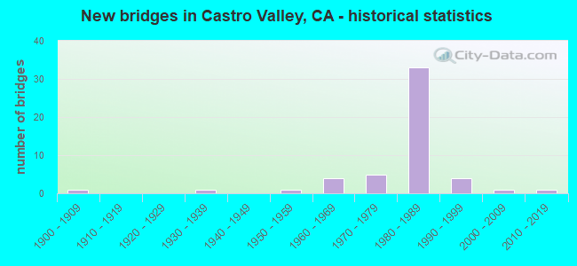
- New bridges - historical statistics
- 11900-1909
- 11930-1939
- 11950-1959
- 41960-1969
- 51970-1979
- 331980-1989
- 41990-1999
- 12000-2009
- 12010-2019

- Reconstructed bridges - Historical Statistics
- 11910-1919
- 01920-1929
- 01930-1939
- 01940-1949
- 01950-1959
- 01960-1969
- 11970-1979
- 01980-1989
- 01990-1999
- 02000-2009
- 12010-2019


- Bridge Condition - Deck
- 45.2%Good
- 9.7%Satisfactory
- 38.7%Fair
- 6.5%Poor

- Bridge Condition - Superstructure
- 75.0%Good
- 3.1%Satisfactory
- 21.9%Fair

- Bridge Condition - Substructure
- 81.3%Good
- 18.8%Fair

- Bridge Condition - Channel
- 25.0%Excellent
- 30.0%Very good
- 40.0%Good
- 5.0%Satisfactory

- Bridge Condition - Culverts
- 20.0%Good
- 80.0%Satisfactory
Find on map >> Show street view
Structure Number: 33 0189L, Location: 04-ALA-580-30.36 (Lat: 37.690550, Lng: -122.088622), Route carried "on" structure: Interstate 580, Year Built: 1988, Year Reconstructed: 2010, Status: Open, Structure Length: 5.35m (17.55ft), Average Daily Traffic: 102,000 (year 2017), Truck Traffic: 6%, Average Future Daily Traffic: 110,289 (year 2037), Design Load: HS 20+Mod, Features Intersected: STROBRIDGE AVE
Minimum Vertical Clearance: 30+ m (98+ ft), Kilometerpoint: 30.360, Lanes on structure: 6, Lanes under structure: 4, Base Highway Network: Yes (Inventory Route: 5, Subroute: 1), Owner: State Highway Agency, Approaching Roadway Width: 27.3m (89.6ft), Skew: 2 degrees, Material/Design: Concrete continuous, Design/Construction: Box Beam or Girders - Multiple, Number Of Spans In Main Unit: 3, Length of Maximum Span: 29.7m (97.4ft), Curb-To-Curb Width: 27.3m (89.6ft), Out-to-Out Width: 28.3m (92.8ft)
Condition: Deck: Fair, Superstructure: Good, Substructure: Good, Operating Rating: 54.1 metric tons, Method Used To Determine Operating Rating: Assigned rating based on Load Factor Design (LFD) reported in metric tons, Inventory Rating: 32.4 metric tons, Method Used To Determine Inventory Rating: Assigned rating based on Load Factor Design (LFD) reported in metric tons, Structural Evaluation: Better than present minimum criteria, Deck Geometry: Equal to present minimum criteria, Underclear: Meets minimum limits, Approach Roadway Alignment: Equal to present desirable criteria, Designated Inspection Frequency: Every 24 months, Inspection Date: April 2020, Deck Structure Type: Concrete Cast-file-Place
Find on map >> Show street view
Structure Number: 33 0189R, Location: 04-ALA-580-30.36 (Lat: 37.690936, Lng: -122.088814), Route carried "on" structure: Interstate 580, Year Built: 1989, Status: Open, Structure Length: 5.52m (18.11ft), Average Daily Traffic: 102,000 (year 2017), Truck Traffic: 6%, Average Future Daily Traffic: 110,289 (year 2037), Design Load: HS 20+Mod, Features Intersected: STROBRIDGE AVE
Minimum Vertical Clearance: 30+ m (98+ ft), Kilometerpoint: 30.360, Lanes on structure: 5, Lanes under structure: 4, Base Highway Network: Yes (Inventory Route: 5, Subroute: 1), Owner: State Highway Agency, Approaching Roadway Width: 23.5m (77.1ft), Skew: 2 degrees, Material/Design: Concrete continuous, Design/Construction: Box Beam or Girders - Multiple, Number Of Spans In Main Unit: 3, Length of Maximum Span: 30.8m (101.0ft), Curb-To-Curb Width: 23.5m (77.1ft), Out-to-Out Width: 24.6m (80.7ft)
Condition: Deck: Fair, Superstructure: Good, Substructure: Good, Operating Rating: 54.1 metric tons, Method Used To Determine Operating Rating: Assigned rating based on Load Factor Design (LFD) reported in metric tons, Inventory Rating: 32.4 metric tons, Method Used To Determine Inventory Rating: Assigned rating based on Load Factor Design (LFD) reported in metric tons, Structural Evaluation: Better than present minimum criteria, Deck Geometry: Equal to present minimum criteria, Underclear: Meets minimum limits, Approach Roadway Alignment: Equal to present desirable criteria, Designated Inspection Frequency: Every 24 months, Inspection Date: April 2020, Deck Structure Type: Concrete Cast-file-Place
Find on map >> Show street view
Structure Number: 33 0193L, Location: 04-ALA-580-R29.37 (Lat: 37.690661, Lng: -122.073439), Route carried "on" structure: Interstate 580, Year Built: 1986, Status: Open, Structure Length: 5.20m (17.06ft), Average Daily Traffic: 103,500 (year 2017), Truck Traffic: 12%, Average Future Daily Traffic: 114,603 (year 2040), Design Load: HS 20+Mod, Features Intersected: REDWOOD ROAD
Minimum Vertical Clearance: 30+ m (98+ ft), Kilometerpoint: 29.370, Lanes on structure: 5, Lanes under structure: 9, Base Highway Network: Yes (Inventory Route: 5, Subroute: 1), Owner: State Highway Agency, Approaching Roadway Width: 23.5m (77.1ft), Skew: 29 degrees, Material/Design: Prestressed concrete, Design/Construction: Box Beam or Girders - Multiple, Number Of Spans In Main Unit: 1, Length of Maximum Span: 51.2m (168.0ft), Curb-To-Curb Width: 23.5m (77.1ft), Out-to-Out Width: 24.6m (80.7ft)
Condition: Deck: Fair, Superstructure: Good, Substructure: Good, Operating Rating: 54.1 metric tons, Method Used To Determine Operating Rating: Assigned rating based on Load Factor Design (LFD) reported in metric tons, Inventory Rating: 32.4 metric tons, Method Used To Determine Inventory Rating: Assigned rating based on Load Factor Design (LFD) reported in metric tons, Structural Evaluation: Better than present minimum criteria, Deck Geometry: Equal to present minimum criteria, Underclear: Meets minimum limits, Approach Roadway Alignment: Equal to present desirable criteria, Designated Inspection Frequency: Every 24 months, Inspection Date: March 2022, Deck Structure Type: Concrete Cast-file-Place
Find on map >> Show street view
Structure Number: 33 0193R, Location: 04-ALA-580-R29.37 (Lat: 37.691050, Lng: -122.073481), Route carried "on" structure: Interstate 580, Year Built: 1987, Status: Open, Structure Length: 5.20m (17.06ft), Average Daily Traffic: 103,500 (year 2017), Truck Traffic: 12%, Average Future Daily Traffic: 114,603 (year 2040), Design Load: HS 20+Mod, Features Intersected: REDWOOD ROAD
Minimum Vertical Clearance: 30+ m (98+ ft), Kilometerpoint: 29.370, Lanes on structure: 5, Lanes under structure: 9, Base Highway Network: Yes (Inventory Route: 5, Subroute: 1), Owner: State Highway Agency, Approaching Roadway Width: 23.5m (77.1ft), Skew: 29 degrees, Material/Design: Prestressed concrete, Design/Construction: Box Beam or Girders - Multiple, Number Of Spans In Main Unit: 1, Length of Maximum Span: 51.2m (168.0ft), Curb-To-Curb Width: 23.5m (77.1ft), Out-to-Out Width: 24.6m (80.7ft)
Condition: Deck: Good, Superstructure: Fair, Substructure: Fair, Operating Rating: 54.1 metric tons, Method Used To Determine Operating Rating: Assigned rating based on Load Factor Design (LFD) reported in metric tons, Inventory Rating: 32.4 metric tons, Method Used To Determine Inventory Rating: Assigned rating based on Load Factor Design (LFD) reported in metric tons, Structural Evaluation: Somewhat better than minimum adequacy, Deck Geometry: Equal to present minimum criteria, Underclear: Meets minimum limits, Approach Roadway Alignment: Equal to present desirable criteria, Designated Inspection Frequency: Every 24 months, Inspection Date: March 2022, Deck Structure Type: Concrete Cast-file-Place
Find on map >> Show street view
Structure Number: 33 0202R, Location: 04-ALA-580-R30.56 (Lat: 37.690858, Lng: -122.092675), Route carried "on" structure: Interstate 580, Year Built: 1989, Status: Open, Structure Length: 7.32m (24.02ft), Average Daily Traffic: 102,000 (year 2017), Truck Traffic: 6%, Average Future Daily Traffic: 110,289 (year 2037), Design Load: HS 20+Mod, Features Intersected: CASTRO VALLEY BLVD
Minimum Vertical Clearance: 30+ m (98+ ft), Kilometerpoint: 30.560, Lanes on structure: 5, Lanes under structure: 4, Base Highway Network: Yes (Inventory Route: 5, Subroute: 1), Owner: State Highway Agency, Approaching Roadway Width: 23.6m (77.4ft), Skew: 4 degrees, Material/Design: Prestressed concrete continuous, Design/Construction: Box Beam or Girders - Multiple, Number Of Spans In Main Unit: 2, Length of Maximum Span: 36.3m (119.1ft), Curb-To-Curb Width: 23.6m (77.4ft), Out-to-Out Width: 24.6m (80.7ft)
Condition: Deck: Good, Superstructure: Good, Substructure: Fair, Operating Rating: 54.1 metric tons, Method Used To Determine Operating Rating: Assigned rating based on Load Factor Design (LFD) reported in metric tons, Inventory Rating: 32.4 metric tons, Method Used To Determine Inventory Rating: Assigned rating based on Load Factor Design (LFD) reported in metric tons, Structural Evaluation: Somewhat better than minimum adequacy, Deck Geometry: Equal to present minimum criteria, Underclear: Meets minimum limits, Approach Roadway Alignment: Equal to present desirable criteria, Designated Inspection Frequency: Every 24 months, Inspection Date: April 2020, Deck Structure Type: Concrete Cast-file-Place
Find on map >> Show street view
Structure Number: 33 0214L, Location: 04-ALA-580-R30.59 (Lat: 37.690186, Lng: -122.093347), Route carried "on" structure: Interstate 580, Year Built: 1988, Status: Open, Structure Length: 61.87m (202.99ft), Average Daily Traffic: 102,000 (year 2017), Truck Traffic: 6%, Average Future Daily Traffic: 110,289 (year 2037), Design Load: HS 20+Mod, Features Intersected: I 238 NB,CONNS,CASTRO VL
Minimum Vertical Clearance: 30+ m (98+ ft), Kilometerpoint: 30.590, Lanes on structure: 3, Lanes under structure: 33, Base Highway Network: Yes (Inventory Route: 5, Subroute: 1), Owner: State Highway Agency, Approaching Roadway Width: 15.5m (50.9ft), Skew: 9 degrees, Material/Design: Prestressed concrete continuous, Design/Construction: Box Beam or Girders - Multiple, Number Of Spans In Main Unit: 14, Length of Maximum Span: 60.0m (196.9ft), Curb-To-Curb Width: 15.5m (50.9ft), Out-to-Out Width: 16.6m (54.5ft)
Condition: Deck: Good, Superstructure: Good, Substructure: Fair, Operating Rating: 54.1 metric tons, Method Used To Determine Operating Rating: Assigned rating based on Load Factor Design (LFD) reported in metric tons, Inventory Rating: 32.4 metric tons, Method Used To Determine Inventory Rating: Assigned rating based on Load Factor Design (LFD) reported in metric tons, Structural Evaluation: Somewhat better than minimum adequacy, Deck Geometry: Somewhat better than minimum adequacy, Underclear: High priority of corrective action, Approach Roadway Alignment: Equal to present desirable criteria, Designated Inspection Frequency: Every 24 months, Inspection Date: April 2020, Deck Structure Type: Concrete Cast-file-Place
Find on map >> Show street view
Structure Number: 33 0225L, Location: 04-ALA-580-R26.23 (Lat: 37.701308, Lng: -122.020903), Route carried "on" structure: Interstate 580, Year Built: 1986, Status: Open, Structure Length: 4.19m (13.75ft), Average Daily Traffic: 98,500 (year 2017), Average Future Daily Traffic: 111,992 (year 2040), Design Load: HS 20+Mod, Features Intersected: EDEN CANYON ROAD
Minimum Vertical Clearance: 30+ m (98+ ft), Kilometerpoint: 26.230, Lanes on structure: 4, Lanes under structure: 3, Base Highway Network: Yes (Inventory Route: 5, Subroute: 1), Owner: State Highway Agency, Approaching Roadway Width: 19.9m (65.3ft), Material/Design: Prestressed concrete, Design/Construction: Box Beam or Girders - Multiple, Number Of Spans In Main Unit: 1, Length of Maximum Span: 41.9m (137.5ft), Curb-To-Curb Width: 19.9m (65.3ft), Out-to-Out Width: 21.0m (68.9ft)
Condition: Deck: Good, Superstructure: Good, Substructure: Good, Operating Rating: 54.1 metric tons, Method Used To Determine Operating Rating: Assigned rating based on Load Factor Design (LFD) reported in metric tons, Inventory Rating: 32.4 metric tons, Method Used To Determine Inventory Rating: Assigned rating based on Load Factor Design (LFD) reported in metric tons, Structural Evaluation: Better than present minimum criteria, Deck Geometry: Equal to present minimum criteria, Underclear: Somewhat better than minimum adequacy, Approach Roadway Alignment: Equal to present desirable criteria, Designated Inspection Frequency: Every 24 months, Inspection Date: March 2022, Deck Structure Type: Concrete Cast-file-Place
Find on map >> Show street view
Structure Number: 33 0225R, Location: 04-ALA-580-R26.23 (Lat: 37.701647, Lng: -122.021019), Route carried "on" structure: Interstate 580, Year Built: 1986, Status: Open, Structure Length: 4.08m (13.39ft), Average Daily Traffic: 98,500 (year 2017), Average Future Daily Traffic: 111,992 (year 2040), Design Load: HS 20+Mod, Features Intersected: EDEN CANYON ROAD
Minimum Vertical Clearance: 30+ m (98+ ft), Kilometerpoint: 26.230, Lanes on structure: 4, Lanes under structure: 2, Base Highway Network: Yes (Inventory Route: 5, Subroute: 1), Owner: State Highway Agency, Approaching Roadway Width: 19.9m (65.3ft), Material/Design: Prestressed concrete, Design/Construction: Box Beam or Girders - Multiple, Number Of Spans In Main Unit: 1, Length of Maximum Span: 40.1m (131.6ft), Curb-To-Curb Width: 19.9m (65.3ft), Out-to-Out Width: 21.0m (68.9ft)
Condition: Deck: Good, Superstructure: Good, Substructure: Good, Operating Rating: 54.1 metric tons, Method Used To Determine Operating Rating: Assigned rating based on Load Factor Design (LFD) reported in metric tons, Inventory Rating: 32.4 metric tons, Method Used To Determine Inventory Rating: Assigned rating based on Load Factor Design (LFD) reported in metric tons, Structural Evaluation: Better than present minimum criteria, Deck Geometry: Equal to present minimum criteria, Underclear: Better than present minimum criteria, Approach Roadway Alignment: Equal to present desirable criteria, Designated Inspection Frequency: Every 24 months, Inspection Date: March 2022, Deck Structure Type: Concrete Cast-file-Place
Find on map >> Show street view
Structure Number: 33 0228L, Location: 04-ALA-580-R27.53 (Lat: 37.697725, Lng: -122.042472), Route carried "on" structure: Interstate 580, Year Built: 1986, Status: Open, Structure Length: 15.15m (49.70ft), Average Daily Traffic: 98,500 (year 2017), Average Future Daily Traffic: 111,992 (year 2040), Design Load: HS 20+Mod, Features Intersected: SAN LORENZO CR,OLD DUBLN
Minimum Vertical Clearance: 30+ m (98+ ft), Kilometerpoint: 27.530, Lanes on structure: 4, Lanes under structure: 2, Base Highway Network: Yes (Inventory Route: 5, Subroute: 1), Owner: State Highway Agency, Approaching Roadway Width: 20.1m (65.9ft), Skew: 3 degrees, Material/Design: Concrete continuous, Design/Construction: Box Beam or Girders - Multiple, Number Of Spans In Main Unit: 5, Length of Maximum Span: 36.6m (120.1ft), Curb-To-Curb Width: 19.9m (65.3ft), Out-to-Out Width: 21.0m (68.9ft)
Condition: Deck: Satisfactory, Superstructure: Fair, Substructure: Good, Channel: Very good, Operating Rating: 54.1 metric tons, Method Used To Determine Operating Rating: Assigned rating based on Load Factor Design (LFD) reported in metric tons, Inventory Rating: 32.4 metric tons, Method Used To Determine Inventory Rating: Assigned rating based on Load Factor Design (LFD) reported in metric tons, Structural Evaluation: Somewhat better than minimum adequacy, Deck Geometry: Equal to present minimum criteria, Underclear: Superior to present desirable criteria, Waterway Adequacy: Equal to present desirable criteria, Approach Roadway Alignment: Equal to present desirable criteria, Designated Inspection Frequency: Every 24 months, Inspection Date: March 2022, Deck Structure Type: Concrete Cast-file-Place
Find on map >> Show street view
Structure Number: 33 0230R, Location: 04-ALA-580-R27.53 (Lat: 37.697789, Lng: -122.042975), Route carried "on" structure: Interstate 580, Year Built: 1986, Status: Open, Structure Length: 34.02m (111.61ft), Average Daily Traffic: 98,500 (year 2017), Average Future Daily Traffic: 111,992 (year 2040), Design Load: HS 20+Mod, Features Intersected: SAN LORENZO CR OLD DUBLN
Minimum Vertical Clearance: 30+ m (98+ ft), Kilometerpoint: 27.530, Lanes on structure: 4, Lanes under structure: 4, Base Highway Network: Yes (Inventory Route: 5, Subroute: 1), Owner: State Highway Agency, Approaching Roadway Width: 20.1m (65.9ft), Skew: 9 degrees, Material/Design: Prestressed concrete continuous, Design/Construction: Box Beam or Girders - Multiple, Number Of Spans In Main Unit: 8, Length of Maximum Span: 48.8m (160.1ft), Curb-To-Curb Width: 19.9m (65.3ft), Out-to-Out Width: 21.0m (68.9ft)
Condition: Deck: Satisfactory, Superstructure: Good, Substructure: Good, Channel: Excellent, Operating Rating: 54.1 metric tons, Method Used To Determine Operating Rating: Assigned rating based on Load Factor Design (LFD) reported in metric tons, Inventory Rating: 32.4 metric tons, Method Used To Determine Inventory Rating: Assigned rating based on Load Factor Design (LFD) reported in metric tons, Structural Evaluation: Better than present minimum criteria, Deck Geometry: Equal to present minimum criteria, Underclear: Superior to present desirable criteria, Waterway Adequacy: Superior to present desirable criteria, Approach Roadway Alignment: Equal to present desirable criteria, Designated Inspection Frequency: Every 24 months, Inspection Date: March 2022, Deck Structure Type: Concrete Cast-file-Place
Find on map >> Show street view
Structure Number: 33 0232L, Location: 04-ALA-580-R28.57 (Lat: 37.693425, Lng: -122.059475), Route carried "on" structure: Interstate 580, Year Built: 1988, Status: Open, Structure Length: 8.15m (26.74ft), Average Daily Traffic: 98,500 (year 2017), Truck Traffic: 12%, Average Future Daily Traffic: 114,603 (year 2040), Design Load: HS 20+Mod, Features Intersected: CROW CREEK
Minimum Vertical Clearance: 30+ m (98+ ft), Kilometerpoint: 28.570, Lanes on structure: 4, Base Highway Network: Yes (Inventory Route: 5, Subroute: 1), Owner: State Highway Agency, Approaching Roadway Width: 20.1m (65.9ft), Skew: 9 degrees, Material/Design: Prestressed concrete continuous, Design/Construction: Box Beam or Girders - Multiple, Number Of Spans In Main Unit: 3, Length of Maximum Span: 39.7m (130.2ft), Curb-To-Curb Width: 19.9m (65.3ft), Out-to-Out Width: 21.0m (68.9ft)
Condition: Deck: Good, Superstructure: Good, Substructure: Good, Channel: Satisfactory, Operating Rating: 54.1 metric tons, Method Used To Determine Operating Rating: Assigned rating based on Load Factor Design (LFD) reported in metric tons, Inventory Rating: 32.4 metric tons, Method Used To Determine Inventory Rating: Assigned rating based on Load Factor Design (LFD) reported in metric tons, Structural Evaluation: Better than present minimum criteria, Deck Geometry: Equal to present minimum criteria, Waterway Adequacy: Equal to present desirable criteria, Approach Roadway Alignment: Equal to present desirable criteria, Designated Inspection Frequency: Every 24 months, Inspection Date: March 2022, Deck Structure Type: Concrete Cast-file-Place
Find on map >> Show street view
Structure Number: 33 0232R, Location: 04-ALA-580-R28.57 (Lat: 37.693842, Lng: -122.059203), Route carried "on" structure: Interstate 580, Year Built: 1988, Status: Open, Structure Length: 8.19m (26.87ft), Average Daily Traffic: 98,500 (year 2017), Truck Traffic: 12%, Average Future Daily Traffic: 114,603 (year 2040), Design Load: HS 20+Mod, Features Intersected: CROW CREEK
Minimum Vertical Clearance: 30+ m (98+ ft), Kilometerpoint: 28.570, Lanes on structure: 4, Base Highway Network: Yes (Inventory Route: 5, Subroute: 1), Owner: State Highway Agency, Approaching Roadway Width: 20.1m (65.9ft), Skew: 9 degrees, Material/Design: Prestressed concrete continuous, Design/Construction: Box Beam or Girders - Multiple, Number Of Spans In Main Unit: 3, Length of Maximum Span: 34.1m (111.9ft), Curb-To-Curb Width: 19.9m (65.3ft), Out-to-Out Width: 21.0m (68.9ft)
Condition: Deck: Poor, Superstructure: Good, Substructure: Good, Channel: Very good, Operating Rating: 54.1 metric tons, Method Used To Determine Operating Rating: Assigned rating based on Load Factor Design (LFD) reported in metric tons, Inventory Rating: 32.4 metric tons, Method Used To Determine Inventory Rating: Assigned rating based on Load Factor Design (LFD) reported in metric tons, Structural Evaluation: Better than present minimum criteria, Deck Geometry: Equal to present minimum criteria, Waterway Adequacy: Equal to present desirable criteria, Approach Roadway Alignment: Equal to present desirable criteria, Designated Inspection Frequency: Every 24 months, Inspection Date: March 2022, Deck Structure Type: Concrete Cast-file-Place
Find on map >> Show street view
Structure Number: 33 0233L, Location: 04-ALA-580-R28.41 (Lat: 37.693672, Lng: -122.056633), Route carried "on" structure: Interstate 580, Year Built: 1988, Status: Open, Structure Length: 8.28m (27.17ft), Average Daily Traffic: 98,500 (year 2017), Average Future Daily Traffic: 111,992 (year 2040), Design Load: HS 20+Mod, Features Intersected: GROVE WAY
Minimum Vertical Clearance: 30+ m (98+ ft), Kilometerpoint: 28.410, Lanes on structure: 5, Lanes under structure: 6, Base Highway Network: Yes (Inventory Route: 5, Subroute: 1), Owner: State Highway Agency, Approaching Roadway Width: 23.2m (76.1ft), Skew: 9 degrees, Material/Design: Prestressed concrete continuous, Design/Construction: Box Beam or Girders - Multiple, Number Of Spans In Main Unit: 3, Length of Maximum Span: 45.1m (148.0ft), Curb-To-Curb Width: 23.2m (76.1ft), Out-to-Out Width: 24.2m (79.4ft)
Condition: Deck: Good, Superstructure: Good, Substructure: Good, Operating Rating: 54.1 metric tons, Method Used To Determine Operating Rating: Assigned rating based on Load Factor Design (LFD) reported in metric tons, Inventory Rating: 32.4 metric tons, Method Used To Determine Inventory Rating: Assigned rating based on Load Factor Design (LFD) reported in metric tons, Structural Evaluation: Better than present minimum criteria, Deck Geometry: Somewhat better than minimum adequacy, Underclear: Superior to present desirable criteria, Approach Roadway Alignment: Equal to present desirable criteria, Designated Inspection Frequency: Every 24 months, Inspection Date: March 2022, Deck Structure Type: Concrete Cast-file-Place
Find on map >> Show street view
Structure Number: 33 0233R, Location: 04-ALA-580-R28.41 (Lat: 37.694067, Lng: -122.056294), Route carried "on" structure: Interstate 580, Year Built: 1988, Status: Open, Structure Length: 8.17m (26.80ft), Average Daily Traffic: 98,500 (year 2017), Average Future Daily Traffic: 111,992 (year 2040), Design Load: HS 20+Mod, Features Intersected: GROVE WAY
Minimum Vertical Clearance: 30+ m (98+ ft), Kilometerpoint: 28.410, Lanes on structure: 5, Lanes under structure: 6, Base Highway Network: Yes (Inventory Route: 5, Subroute: 1), Owner: State Highway Agency, Approaching Roadway Width: 23.2m (76.1ft), Skew: 9 degrees, Material/Design: Prestressed concrete continuous, Design/Construction: Box Beam or Girders - Multiple, Number Of Spans In Main Unit: 3, Length of Maximum Span: 44.5m (146.0ft), Curb-To-Curb Width: 23.2m (76.1ft), Out-to-Out Width: 24.2m (79.4ft)
Condition: Deck: Fair, Superstructure: Good, Substructure: Good, Operating Rating: 54.1 metric tons, Method Used To Determine Operating Rating: Assigned rating based on Load Factor Design (LFD) reported in metric tons, Inventory Rating: 32.4 metric tons, Method Used To Determine Inventory Rating: Assigned rating based on Load Factor Design (LFD) reported in metric tons, Structural Evaluation: Better than present minimum criteria, Deck Geometry: Somewhat better than minimum adequacy, Underclear: Equal to present minimum criteria, Approach Roadway Alignment: Equal to present desirable criteria, Designated Inspection Frequency: Every 24 months, Inspection Date: March 2022, Deck Structure Type: Concrete Cast-file-Place
Find on map >> Show street view
Structure Number: 33 0234, Location: 04-ALA-580-R27.16 (Lat: 37.701981, Lng: -122.036439), Route carried "on" structure: Interstate 580, Year Built: 1957, Year Reconstructed: 1977, Status: Open, Structure Length: 0.63m (2.07ft), Average Daily Traffic: 197,000 (year 2017), Average Future Daily Traffic: 223,983 (year 2040), Features Intersected: SAN LORENZO CREEK
Minimum Vertical Clearance: 30+ m (98+ ft), Kilometerpoint: 27.160, Lanes on structure: 8, Base Highway Network: Yes (Inventory Route: 5, Subroute: 1), Owner: State Highway Agency, Approaching Roadway Width: 40.2m (131.9ft), Skew: 9 degrees, Material/Design: Concrete, Design/Construction: Arch - Deck, Number Of Spans In Main Unit: 1, Length of Maximum Span: 6.3m (20.7ft)
Condition: Superstructure: Fair, Substructure: Good, Channel: Good, Operating Rating: 54.1 metric tons, Method Used To Determine Operating Rating: Field evaluation and documented engineering judgment, Inventory Rating: 32.4 metric tons, Method Used To Determine Inventory Rating: Field evaluation and documented engineering judgment, Structural Evaluation: Somewhat better than minimum adequacy, Waterway Adequacy: Superior to present desirable criteria, Approach Roadway Alignment: Equal to present desirable criteria, Designated Inspection Frequency: Every 24 months, Inspection Date: March 2022
Find on map >> Show street view
Structure Number: 33 0235L, Location: 04-ALA-580-R27.00 (Lat: 37.702003, Lng: -122.034314), Route carried "on" structure: Interstate 580, Year Built: 1986, Status: Open, Structure Length: 21.95m (72.01ft), Average Daily Traffic: 98,500 (year 2017), Average Future Daily Traffic: 111,992 (year 2040), Design Load: HS 20+Mod, Features Intersected: EAST CASTRO VALLEY BLVD
Minimum Vertical Clearance: 30+ m (98+ ft), Kilometerpoint: 27.000, Lanes on structure: 4, Lanes under structure: 2, Base Highway Network: Yes (Inventory Route: 5, Subroute: 1), Owner: State Highway Agency, Approaching Roadway Width: 19.9m (65.3ft), Skew: 9 degrees, Material/Design: Prestressed concrete continuous, Design/Construction: Box Beam or Girders - Multiple, Number Of Spans In Main Unit: 5, Length of Maximum Span: 48.8m (160.1ft), Curb-To-Curb Width: 19.9m (65.3ft), Out-to-Out Width: 21.0m (68.9ft)
Condition: Deck: Good, Superstructure: Fair, Substructure: Good, Channel: Excellent, Operating Rating: 54.1 metric tons, Method Used To Determine Operating Rating: Assigned rating based on Load Factor Design (LFD) reported in metric tons, Inventory Rating: 32.4 metric tons, Method Used To Determine Inventory Rating: Assigned rating based on Load Factor Design (LFD) reported in metric tons, Structural Evaluation: Somewhat better than minimum adequacy, Deck Geometry: Equal to present minimum criteria, Underclear: Equal to present minimum criteria, Waterway Adequacy: Superior to present desirable criteria, Approach Roadway Alignment: Equal to present desirable criteria, Designated Inspection Frequency: Every 24 months, Inspection Date: March 2022, Deck Structure Type: Concrete Cast-file-Place, Wearing Surface/Protective System: Wearing Surface: Integral Concrete
Find on map >> Show street view
Structure Number: 33 0235R, Location: 04-ALA-580-R27.00 (Lat: 37.702208, Lng: -122.035386), Route carried "on" structure: Interstate 580, Year Built: 1986, Status: Open, Structure Length: 23.01m (75.49ft), Average Daily Traffic: 98,500 (year 2017), Average Future Daily Traffic: 111,992 (year 2040), Design Load: HS 20+Mod, Features Intersected: EAST CASTRO VALLEY BLVD
Minimum Vertical Clearance: 30+ m (98+ ft), Kilometerpoint: 27.000, Lanes on structure: 4, Lanes under structure: 3, Base Highway Network: Yes (Inventory Route: 5, Subroute: 1), Owner: State Highway Agency, Approaching Roadway Width: 19.9m (65.3ft), Skew: 9 degrees, Material/Design: Prestressed concrete continuous, Design/Construction: Box Beam or Girders - Multiple, Number Of Spans In Main Unit: 5, Length of Maximum Span: 53.3m (174.9ft), Curb-To-Curb Width: 19.9m (65.3ft), Out-to-Out Width: 21.0m (68.9ft)
Condition: Deck: Fair, Superstructure: Good, Substructure: Good, Channel: Excellent, Operating Rating: 54.1 metric tons, Method Used To Determine Operating Rating: Assigned rating based on Load Factor Design (LFD) reported in metric tons, Inventory Rating: 32.4 metric tons, Method Used To Determine Inventory Rating: Assigned rating based on Load Factor Design (LFD) reported in metric tons, Structural Evaluation: Better than present minimum criteria, Deck Geometry: Equal to present minimum criteria, Underclear: Equal to present desirable criteria, Waterway Adequacy: Superior to present desirable criteria, Approach Roadway Alignment: Equal to present desirable criteria, Designated Inspection Frequency: Every 24 months, Inspection Date: March 2022, Deck Structure Type: Concrete Cast-file-Place
Find on map >> Show street view
Structure Number: 33 0336, Location: 04-ALA-580-R32.84 (Lat: 37.709514, Lng: -122.124369), Route carried "on" structure: County highway , Year Built: 1965, Status: Open, Structure Length: 4.45m (14.60ft), Average Daily Traffic: 14,000 (year 2009), Truck Traffic: 3%, Average Future Daily Traffic: 16,194 (year 2038), Design Load: HS 20, Features Intersected: INTERSTATE 580, Facility Carried by Structure: 150TH AVE
Minimum Vertical Clearance: 30+ m (98+ ft), Kilometerpoint: 0.000, Lanes on structure: 4, Lanes under structure: 8, Owner: State Highway Agency, Approaching Roadway Width: 17.1m (56.1ft), Skew: 9 degrees, Material/Design: Concrete continuous, Design/Construction: Box Beam or Girders - Multiple, Number Of Spans In Main Unit: 2, Length of Maximum Span: 22.3m (73.2ft), Curb or Sidewalk Widths: Left: 1.5m (4.9ft), Right: 1.5m (4.9ft), Curb-To-Curb Width: 17.3m (56.8ft), Out-to-Out Width: 21.4m (70.2ft)
Condition: Deck: Fair, Superstructure: Fair, Substructure: Good, Operating Rating: 47.6 metric tons, Method Used To Determine Operating Rating: Load and Resistance Factor Rating (LRFR) rating reported by rating factor(RF) method using HL-93 loadings, Inventory Rating: 36.9 metric tons, Method Used To Determine Inventory Rating: Load and Resistance Factor Rating (LRFR) rating reported by rating factor(RF) method using HL-93 loadings, Structural Evaluation: Somewhat better than minimum adequacy, Deck Geometry: Somewhat better than minimum adequacy, Underclear: Meets minimum limits, Approach Roadway Alignment: Equal to present minimum criteria, Designated Inspection Frequency: Every 24 months, Inspection Date: April 2020, Deck Structure Type: Concrete Cast-file-Place
Find on map >> Show street view
Structure Number: 33 0395R, Location: 04-ALA-580-R31.71 (Lat: 37.699969, Lng: -122.108075), Route carried "on" structure: Interstate 580, Year Built: 1965, Status: Open, Structure Length: 6.38m (20.93ft), Average Daily Traffic: 79,000 (year 2017), Average Future Daily Traffic: 102,357 (year 2037), Design Load: HS 20, Features Intersected: 164TH AVENUE
Minimum Vertical Clearance: 30+ m (98+ ft), Kilometerpoint: 31.710, Lanes on structure: 4, Lanes under structure: 4, Base Highway Network: Yes (Inventory Route: 5, Subroute: 1), Owner: State Highway Agency, Approaching Roadway Width: 20.1m (65.9ft), Skew: 4 degrees, Material/Design: Concrete continuous, Design/Construction: Box Beam or Girders - Multiple, Number Of Spans In Main Unit: 3, Length of Maximum Span: 29.1m (95.5ft), Curb-To-Curb Width: 20.1m (65.9ft), Out-to-Out Width: 20.7m (67.9ft)
Condition: Deck: Fair, Superstructure: Good, Substructure: Fair, Operating Rating: 37.3 metric tons, Method Used To Determine Operating Rating: Load and Resistance Factor Rating (LRFR) rating reported by rating factor(RF) method using HL-93 loadings, Inventory Rating: 28.5 metric tons, Method Used To Determine Inventory Rating: Load and Resistance Factor Rating (LRFR) rating reported by rating factor(RF) method using HL-93 loadings, Structural Evaluation: Somewhat better than minimum adequacy, Deck Geometry: Equal to present minimum criteria, Underclear: Meets minimum limits, Approach Roadway Alignment: Equal to present desirable criteria, Length Of Structure Improvement: 6.40m (21.00ft), Designated Inspection Frequency: Every 24 months, Inspection Date: April 2020, Deck Structure Type: Concrete Cast-file-Place
Find on map >> Show street view
Structure Number: 33 0422, Location: 04-ALA-580-R28.75 (Lat: 37.692242, Lng: -122.062308), Route carried "on" structure: County highway , Year Built: 1986, Status: Open, Structure Length: 11.34m (37.20ft), Average Daily Traffic: 24,370 (year 1998), Truck Traffic: 2%, Average Future Daily Traffic: 32,930 (year 2044), Design Load: HS 20+Mod, Features Intersected: INTERSTATE 580, Facility Carried by Structure: CENTER STREET
Minimum Vertical Clearance: 30+ m (98+ ft), Kilometerpoint: 0.000, Lanes on structure: 6, Lanes under structure: 10, Owner: State Highway Agency, Approaching Roadway Width: 30.5m (100.1ft), Skew: 22 degrees, Material/Design: Prestressed concrete continuous, Design/Construction: Box Beam or Girders - Multiple, Number Of Spans In Main Unit: 2, Length of Maximum Span: 59.4m (194.9ft), Curb or Sidewalk Widths: Left: 1.5m (4.9ft), Right: 1.5m (4.9ft), Curb-To-Curb Width: 27.4m (89.9ft), Out-to-Out Width: 32.9m (107.9ft)
Condition: Deck: Good, Superstructure: Good, Substructure: Good, Operating Rating: 54.1 metric tons, Method Used To Determine Operating Rating: Assigned rating based on Load Factor Design (LFD) reported in metric tons, Inventory Rating: 32.4 metric tons, Method Used To Determine Inventory Rating: Assigned rating based on Load Factor Design (LFD) reported in metric tons, Structural Evaluation: Better than present minimum criteria, Deck Geometry: Better than present minimum criteria, Underclear: Equal to present minimum criteria, Approach Roadway Alignment: Equal to present desirable criteria, Designated Inspection Frequency: Every 24 months, Inspection Date: March 2022, Deck Structure Type: Concrete Cast-file-Place
Find on map >> Show street view
Structure Number: 33 0432G, Location: 04-ALA-238-R14.47 (Lat: 37.688408, Lng: -122.095281), Route carried "on" structure: Ramp State highway 238, Year Built: 1988, Status: Open, Structure Length: 5.52m (18.11ft), Average Daily Traffic: 23,200 (year 2003), Truck Traffic: 11%, Average Future Daily Traffic: 27,351 (year 2042), Design Load: HS 20+Mod, Features Intersected: CASTRO VALLEY BLVD
Minimum Vertical Clearance: 30+ m (98+ ft), Kilometerpoint: 14.470, Lanes on structure: 3, Lanes under structure: 6, Owner: State Highway Agency, Approaching Roadway Width: 16.5m (54.1ft), Material/Design: Concrete continuous, Design/Construction: Box Beam or Girders - Multiple, Number Of Spans In Main Unit: 2, Length of Maximum Span: 28.0m (91.9ft), Curb-To-Curb Width: 15.4m (50.5ft), Out-to-Out Width: 16.5m (54.1ft)
Condition: Deck: Poor, Superstructure: Fair, Substructure: Good, Operating Rating: 54.1 metric tons, Method Used To Determine Operating Rating: Assigned rating based on Load Factor Design (LFD) reported in metric tons, Inventory Rating: 32.4 metric tons, Method Used To Determine Inventory Rating: Assigned rating based on Load Factor Design (LFD) reported in metric tons, Structural Evaluation: Somewhat better than minimum adequacy, Deck Geometry: Superior to present desirable criteria, Underclear: Somewhat better than minimum adequacy, Approach Roadway Alignment: Equal to present desirable criteria, Designated Inspection Frequency: Every 24 months, Inspection Date: Febuary 2022, Deck Structure Type: Concrete Cast-file-Place
Find on map >> Show street view
Structure Number: 33 0443, Location: 04-ALA-238-R14.47 (Lat: 37.689056, Lng: -122.094692), Route carried "on" structure: County highway , Year Built: 1990, Status: Open, Structure Length: 3.78m (12.40ft), Average Daily Traffic: 30,000 (year 1998), Truck Traffic: 1%, Average Future Daily Traffic: 54,700 (year 2042), Design Load: HS 20, Features Intersected: STATE ROUTE 238 NB, Facility Carried by Structure: CASTRO VALLEY BLVD
Minimum Vertical Clearance: 30+ m (98+ ft), Kilometerpoint: 0.000, Lanes on structure: 5, Lanes under structure: 1, Base Highway Network: Yes, Owner: State Highway Agency, Approaching Roadway Width: 25.6m (84.0ft), Skew: 29 degrees, Material/Design: Concrete continuous, Design/Construction: Box Beam or Girders - Multiple, Number Of Spans In Main Unit: 3, Length of Maximum Span: 18.3m (60.0ft), Curb or Sidewalk Widths: Left: 0.0m, Right: 2.4m (7.9ft), Curb-To-Curb Width: 24.1m (79.1ft), Out-to-Out Width: 28.9m (94.8ft)
Condition: Deck: Satisfactory, Superstructure: Satisfactory, Substructure: Good, Operating Rating: 54.1 metric tons, Method Used To Determine Operating Rating: Assigned rating based on Load Factor Design (LFD) reported in metric tons, Inventory Rating: 32.4 metric tons, Method Used To Determine Inventory Rating: Assigned rating based on Load Factor Design (LFD) reported in metric tons, Structural Evaluation: Equal to present minimum criteria, Deck Geometry: Superior to present desirable criteria, Underclear: Equal to present minimum criteria, Approach Roadway Alignment: Better than present minimum criteria, Designated Inspection Frequency: Every 48 months, Inspection Date: Febuary 2020, Deck Structure Type: Concrete Cast-file-Place
Find on map >> Show street view
Structure Number: 33 0499, Location: 04-ALA-580-R26.66 (Lat: 37.701011, Lng: -122.028675), Route carried "on" structure: County highway , Year Built: 1986, Status: Open, Structure Length: 12.00m (39.37ft), Average Daily Traffic: 500 (year 1998), Truck Traffic: 3%, Average Future Daily Traffic: 878 (year 2044), Design Load: HS 20, Features Intersected: INTERSTATE 580, Facility Carried by Structure: SUNNYSLOPE AVENUE
Minimum Vertical Clearance: 30+ m (98+ ft), Kilometerpoint: 0.000, Lanes on structure: 2, Lanes under structure: 8, Owner: State Highway Agency, Approaching Roadway Width: 9.8m (32.2ft), Skew: 2 degrees, Material/Design: Prestressed concrete continuous, Design/Construction: Box Beam or Girders - Multiple, Number Of Spans In Main Unit: 3, Length of Maximum Span: 49.7m (163.1ft), Curb or Sidewalk Widths: Left: 1.5m (4.9ft), Right: 0.0m, Curb-To-Curb Width: 9.8m (32.2ft), Out-to-Out Width: 12.1m (39.7ft)
Condition: Deck: Fair, Superstructure: Good, Substructure: Fair, Operating Rating: 54.1 metric tons, Method Used To Determine Operating Rating: Assigned rating based on Load Factor Design (LFD) reported in metric tons, Inventory Rating: 32.4 metric tons, Method Used To Determine Inventory Rating: Assigned rating based on Load Factor Design (LFD) reported in metric tons, Structural Evaluation: Somewhat better than minimum adequacy, Deck Geometry: Equal to present minimum criteria, Underclear: Somewhat better than minimum adequacy, Approach Roadway Alignment: Equal to present desirable criteria, Designated Inspection Frequency: Every 24 months, Inspection Date: March 2022, Deck Structure Type: Concrete Cast-file-Place
Find on map >> Show street view
Structure Number: 33 0523K, Location: 04-ALA-580-R30.80 (Lat: 37.689872, Lng: -122.092506), Route carried "on" structure: Bypass Interstate 580, Year Built: 1988, Status: Open, Structure Length: 7.32m (24.02ft), Average Daily Traffic: 3,000 (year 2017), Truck Traffic: 1%, Average Future Daily Traffic: 8,043 (year 2037), Design Load: HS 20+Mod, Features Intersected: N238-E580 CONNECTOR RAMP
Minimum Vertical Clearance: 30+ m (98+ ft), Kilometerpoint: 30.800, Lanes on structure: 1, Lanes under structure: 2, Base Highway Network: Yes (Inventory Route: 5, Subroute: 1), Owner: State Highway Agency, Approaching Roadway Width: 7.3m (24.0ft), Material/Design: Prestressed concrete continuous, Design/Construction: Box Beam or Girders - Multiple, Number Of Spans In Main Unit: 3, Length of Maximum Span: 36.6m (120.1ft), Curb-To-Curb Width: 7.3m (24.0ft), Out-to-Out Width: 8.4m (27.6ft)
Condition: Deck: Fair, Superstructure: Good, Substructure: Good, Operating Rating: 54.1 metric tons, Method Used To Determine Operating Rating: Assigned rating based on Load Factor Design (LFD) reported in metric tons, Inventory Rating: 32.4 metric tons, Method Used To Determine Inventory Rating: Assigned rating based on Load Factor Design (LFD) reported in metric tons, Structural Evaluation: Better than present minimum criteria, Deck Geometry: High priority of replacement, Underclear: Superior to present desirable criteria, Approach Roadway Alignment: Equal to present desirable criteria, Designated Inspection Frequency: Every 24 months, Inspection Date: April 2020, Deck Structure Type: Concrete Cast-file-Place
Find on map >> Show street view
Structure Number: 33 0675, Location: 04-ALA-580-30.10 (Lat: 37.691000, Lng: -122.082725), Route carried "on" structure: Interstate 580, Year Built: 1980, Status: Open, Structure Length: 0.73m (2.40ft), Average Daily Traffic: 207,000 (year 2017), Truck Traffic: 12%, Average Future Daily Traffic: 224,673 (year 2037), Features Intersected: CASTRO VALLEY DRAINAGE
Minimum Vertical Clearance: 30+ m (98+ ft), Kilometerpoint: 30.100, Lanes on structure: 14, Base Highway Network: Yes (Inventory Route: 5, Subroute: 1), Owner: State Highway Agency, Approaching Roadway Width: 47.5m (155.8ft), Skew: 9 degrees, Material/Design: Concrete continuous, Design/Construction: Culvert, Number Of Spans In Main Unit: 2, Length of Maximum Span: 3.7m (12.1ft)
Condition: Channel: Very good, Culverts: Satisfactory, Operating Rating: 54.1 metric tons, Method Used To Determine Operating Rating: Field evaluation and documented engineering judgment, Inventory Rating: 32.4 metric tons, Method Used To Determine Inventory Rating: Field evaluation and documented engineering judgment, Structural Evaluation: Equal to present minimum criteria, Waterway Adequacy: Superior to present desirable criteria, Approach Roadway Alignment: Equal to present desirable criteria, Designated Inspection Frequency: Every 24 months, Inspection Date: April 2020
Find on map >> Show street view
Structure Number: 33 0733, Location: 04-ALA-580-R29.23-CAVA (Lat: 37.691206, Lng: -122.070778), Route carried "on" structure: Interstate 580, Year Built: 2011, Status: Open, Structure Length: 1.10m (3.61ft), Average Daily Traffic: 7,900 (year 2014), Truck Traffic: 6%, Average Future Daily Traffic: 20,000 (year 2040), Design Load: HS 20+Mod, Features Intersected: ACFC CHANNEL LINES I-J
Minimum Vertical Clearance: 30+ m (98+ ft), Kilometerpoint: 29.230, Lanes on structure: 1, Base Highway Network: Yes (Inventory Route: 5, Subroute: 1), Owner: State Highway Agency, Approaching Roadway Width: 4.4m (14.4ft), Material/Design: Concrete, Design/Construction: Tee Beam, Number Of Spans In Main Unit: 1, Length of Maximum Span: 11.0m (36.1ft), Curb-To-Curb Width: 4.4m (14.4ft), Out-to-Out Width: 4.9m (16.1ft)
Condition: Deck: Good, Superstructure: Good, Substructure: Good, Channel: Excellent, Operating Rating: 54.1 metric tons, Method Used To Determine Operating Rating: Assigned rating based on Load Factor Design (LFD) reported in metric tons, Inventory Rating: 32.4 metric tons, Method Used To Determine Inventory Rating: Assigned rating based on Load Factor Design (LFD) reported in metric tons, Structural Evaluation: Better than present minimum criteria, Deck Geometry: High priority of replacement, Waterway Adequacy: Equal to present desirable criteria, Approach Roadway Alignment: Equal to present desirable criteria, Designated Inspection Frequency: Every 24 months, Inspection Date: March 2022, Deck Structure Type: Concrete Cast-file-Place
Find on map >> Show street view
Structure Number: 33C0054, Location: JUST W/O LAKE (Lat: 37.693936, Lng: -122.087000), Route carried "on" structure: County highway , Year Built: 1900, Year Reconstructed: 1917, Status: Open, Structure Length: 0.73m (2.40ft), Average Daily Traffic: 33,600 (year 2014), Truck Traffic: 2%, Average Future Daily Traffic: 48,136 (year 2042), Features Intersected: LAKE CHABOT CREEK, Facility Carried by Structure: CASTRO VALLEY BLVD
Minimum Vertical Clearance: 30+ m (98+ ft), Kilometerpoint: 0.000, Lanes on structure: 6, Base Highway Network: Yes, Owner: County Highway Agency, Approaching Roadway Width: 24.7m (81.0ft), Skew: 20 degrees, Material/Design: Concrete, Design/Construction: Culvert, Number Of Spans In Main Unit: 1, Length of Maximum Span: 6.1m (20.0ft), Curb or Sidewalk Widths: Left: 0.2m (0.7ft), Right: 1.5m (4.9ft), Curb-To-Curb Width: 24.7m (81.0ft), Out-to-Out Width: 24.7m (81.0ft)
Condition: Channel: Very good, Culverts: Good, Operating Rating: 27.2 metric tons, Method Used To Determine Operating Rating: Field evaluation and documented engineering judgment, Inventory Rating: 16.2 metric tons, Method Used To Determine Inventory Rating: Field evaluation and documented engineering judgment, Structural Evaluation: Meets minimum limits, Deck Geometry: Somewhat better than minimum adequacy, Waterway Adequacy: Superior to present desirable criteria, Approach Roadway Alignment: Equal to present desirable criteria, Designated Inspection Frequency: Every 24 months, Inspection Date: June 2020
Find on map >> Show street view
Structure Number: 33C0075, Location: 0.2 MI W/O CROW CANYON RD (Lat: 37.693978, Lng: -122.059989), Route carried "on" structure: County highway , Year Built: 1988, Status: Open, Structure Length: 8.84m (29.00ft), Average Daily Traffic: 23,800 (year 2014), Truck Traffic: 5%, Average Future Daily Traffic: 37,658 (year 2042), Design Load: HS 20+Mod, Features Intersected: CROW CREEK, Facility Carried by Structure: CASTRO VALLEY BLVD
Minimum Vertical Clearance: 30+ m (98+ ft), Kilometerpoint: 0.000, Lanes on structure: 4, Base Highway Network: Yes, Owner: County Highway Agency, Approaching Roadway Width: 29.3m (96.1ft), Skew: 25 degrees, Material/Design: Prestressed concrete continuous, Design/Construction: Box Beam or Girders - Multiple, Number Of Spans In Main Unit: 3, Length of Maximum Span: 32.0m (105.0ft), Curb or Sidewalk Widths: Left: 1.5m (4.9ft), Right: 1.5m (4.9ft), Curb-To-Curb Width: 20.8m (68.2ft), Out-to-Out Width: 29.3m (96.1ft)
Condition: Deck: Good, Superstructure: Good, Substructure: Good, Channel: Good, Operating Rating: 54.1 metric tons, Method Used To Determine Operating Rating: Assigned rating based on Load Factor Design (LFD) reported in metric tons, Inventory Rating: 32.4 metric tons, Method Used To Determine Inventory Rating: Assigned rating based on Load Factor Design (LFD) reported in metric tons, Structural Evaluation: Better than present minimum criteria, Deck Geometry: Superior to present desirable criteria, Waterway Adequacy: Equal to present desirable criteria, Approach Roadway Alignment: Better than present minimum criteria, Designated Inspection Frequency: Every 24 months, Inspection Date: June 2020, Deck Structure Type: Concrete Cast-file-Place
Find on map >> Show street view
Structure Number: 33C0077, Location: 0.7 MI N/O I-580 (Lat: 37.702322, Lng: -122.053836), Route carried "on" structure: County highway , Year Built: 1971, Status: Open, Structure Length: 0.64m (2.10ft), Average Daily Traffic: 28,800 (year 2014), Truck Traffic: 2%, Average Future Daily Traffic: 32,929 (year 2040), Design Load: HS 20, Features Intersected: CROW CREEK, Facility Carried by Structure: CROW CANYON RD
Minimum Vertical Clearance: 30+ m (98+ ft), Kilometerpoint: 0.000, Lanes on structure: 4, Base Highway Network: Yes, Owner: County Highway Agency, Approaching Roadway Width: 28.7m (94.2ft), Skew: 29 degrees, Material/Design: Concrete, Design/Construction: Slab, Number Of Spans In Main Unit: 1, Length of Maximum Span: 6.4m (21.0ft), Curb or Sidewalk Widths: Left: 1.8m (5.9ft), Right: 0.2m (0.7ft), Curb-To-Curb Width: 28.9m (94.8ft), Out-to-Out Width: 30.6m (100.4ft)
Condition: Deck: Good, Superstructure: Good, Substructure: Good, Channel: Good, Operating Rating: 40.5 metric tons, Method Used To Determine Operating Rating: Field evaluation and documented engineering judgment, Inventory Rating: 24.3 metric tons, Method Used To Determine Inventory Rating: Field evaluation and documented engineering judgment, Structural Evaluation: Equal to present minimum criteria, Deck Geometry: Superior to present desirable criteria, Waterway Adequacy: Superior to present desirable criteria, Approach Roadway Alignment: Equal to present desirable criteria, Designated Inspection Frequency: Every 24 months, Inspection Date: June 2020
Find on map >> Show street view
Structure Number: 33C0078, Location: 1.3 MI NE OF I-580 (Lat: 37.704558, Lng: -122.043875), Route carried "on" structure: County highway , Year Built: 1970, Status: Open, Structure Length: 1.49m (4.89ft), Average Daily Traffic: 28,800 (year 2014), Truck Traffic: 5%, Average Future Daily Traffic: 24,472 (year 2042), Design Load: HS 20, Features Intersected: CROW CREEK, Facility Carried by Structure: CROW CANYON RD
Minimum Vertical Clearance: 30+ m (98+ ft), Kilometerpoint: 0.000, Lanes on structure: 2, Base Highway Network: Yes, Owner: County Highway Agency, Approaching Roadway Width: 12.2m (40.0ft), Skew: 3 degrees, Material/Design: Concrete, Design/Construction: Tee Beam, Number Of Spans In Main Unit: 1, Length of Maximum Span: 13.7m (44.9ft), Curb or Sidewalk Widths: Left: 0.0m, Right: 1.8m (5.9ft), Curb-To-Curb Width: 12.2m (40.0ft), Out-to-Out Width: 14.6m (47.9ft)
Condition: Deck: Good, Superstructure: Good, Substructure: Good, Channel: Good, Operating Rating: 66.7 metric tons, Method Used To Determine Operating Rating: Load and Resistance Factor Rating (LRFR) rating reported by rating factor(RF) method using HL-93 loadings, Inventory Rating: 34.3 metric tons, Method Used To Determine Inventory Rating: Load and Resistance Factor Rating (LRFR) rating reported by rating factor(RF) method using HL-93 loadings, Structural Evaluation: Better than present minimum criteria, Deck Geometry: Somewhat better than minimum adequacy, Waterway Adequacy: Equal to present desirable criteria, Approach Roadway Alignment: Equal to present desirable criteria, Designated Inspection Frequency: Every 48 months, Inspection Date: June 2020, Deck Structure Type: Concrete Cast-file-Place, Wearing Surface/Protective System: Wearing Surface: Bituminous
Find on map >> Show street view
Structure Number: 33C0086, Location: JUST SOUTH OF I-580 (Lat: 37.691822, Lng: -122.059042), Route carried "on" structure: County highway , Year Built: 1988, Status: Open, Structure Length: 11.55m (37.89ft), Average Daily Traffic: 31,100 (year 2014), Truck Traffic: 2%, Average Future Daily Traffic: 37,658 (year 2042), Design Load: HS 20+Mod, Features Intersected: CROW CREEK, Facility Carried by Structure: GROVE WAY
Minimum Vertical Clearance: 30+ m (98+ ft), Kilometerpoint: 0.000, Lanes on structure: 4, Owner: County Highway Agency, Approaching Roadway Width: 27.4m (89.9ft), Skew: 20 degrees, Material/Design: Prestressed concrete continuous, Design/Construction: Box Beam or Girders - Multiple, Number Of Spans In Main Unit: 4, Length of Maximum Span: 38.1m (125.0ft), Curb or Sidewalk Widths: Left: 1.5m (4.9ft), Right: 1.5m (4.9ft), Curb-To-Curb Width: 21.9m (71.9ft), Out-to-Out Width: 31.1m (102.0ft)
Condition: Deck: Fair, Superstructure: Good, Substructure: Good, Channel: Very good, Operating Rating: 54.1 metric tons, Method Used To Determine Operating Rating: Assigned rating based on Load Factor Design (LFD) reported in metric tons, Inventory Rating: 32.4 metric tons, Method Used To Determine Inventory Rating: Assigned rating based on Load Factor Design (LFD) reported in metric tons, Structural Evaluation: Better than present minimum criteria, Deck Geometry: Superior to present desirable criteria, Waterway Adequacy: Equal to present desirable criteria, Approach Roadway Alignment: Equal to present minimum criteria, Designated Inspection Frequency: Every 24 months, Inspection Date: June 2020, Deck Structure Type: Concrete Cast-file-Place
Find on map >> Show street view
Structure Number: 33C0087, Location: 1.7 MI N OF I-580 (Lat: 37.708525, Lng: -122.040642), Route carried "on" structure: County highway , Year Built: 1974, Status: Open, Structure Length: 1.22m (4.00ft), Average Daily Traffic: 28,800 (year 2014), Truck Traffic: 5%, Average Future Daily Traffic: 24,472 (year 2042), Design Load: HS 20, Features Intersected: CROW CREEK, Facility Carried by Structure: CROW CANYON RD
Minimum Vertical Clearance: 30+ m (98+ ft), Kilometerpoint: 0.000, Lanes on structure: 2, Base Highway Network: Yes, Owner: County Highway Agency, Approaching Roadway Width: 12.2m (40.0ft), Skew: 6 degrees, Material/Design: Concrete continuous, Design/Construction: Culvert, Number Of Spans In Main Unit: 2, Length of Maximum Span: 4.0m (13.1ft)
Condition: Channel: Good, Culverts: Satisfactory, Operating Rating: 54.1 metric tons, Method Used To Determine Operating Rating: Field evaluation and documented engineering judgment, Inventory Rating: 32.4 metric tons, Method Used To Determine Inventory Rating: Field evaluation and documented engineering judgment, Structural Evaluation: Equal to present minimum criteria, Waterway Adequacy: Equal to present desirable criteria, Approach Roadway Alignment: Equal to present minimum criteria, Designated Inspection Frequency: Every 48 months, Inspection Date: June 2020
Find on map >> Show street view
Structure Number: 33C0088, Location: 2 MI N OF SH I-580 (Lat: 37.713406, Lng: -122.040192), Route carried "on" structure: County highway , Year Built: 1974, Status: Open, Structure Length: 1.22m (4.00ft), Average Daily Traffic: 28,800 (year 2014), Truck Traffic: 5%, Average Future Daily Traffic: 24,472 (year 2042), Design Load: HS 20, Features Intersected: CROW CREEK, Facility Carried by Structure: CROW CANYON RD
Minimum Vertical Clearance: 30+ m (98+ ft), Kilometerpoint: 0.000, Lanes on structure: 2, Base Highway Network: Yes, Owner: County Highway Agency, Approaching Roadway Width: 12.2m (40.0ft), Skew: 6 degrees, Material/Design: Concrete continuous, Design/Construction: Culvert, Number Of Spans In Main Unit: 2, Length of Maximum Span: 4.0m (13.1ft)
Condition: Channel: Good, Culverts: Satisfactory, Operating Rating: 54.1 metric tons, Method Used To Determine Operating Rating: Field evaluation and documented engineering judgment, Inventory Rating: 32.4 metric tons, Method Used To Determine Inventory Rating: Field evaluation and documented engineering judgment, Structural Evaluation: Equal to present minimum criteria, Waterway Adequacy: Equal to present desirable criteria, Approach Roadway Alignment: Equal to present minimum criteria, Designated Inspection Frequency: Every 48 months, Inspection Date: June 2020
Find on map >> Show street view
Structure Number: 33C0095, Location: 3.2 MI N/O CASTRO VLY BLV (Lat: 37.738169, Lng: -122.076267), Route carried "on" structure: County highway , Year Built: 1931, Status: Open, Structure Length: 2.32m (7.61ft), Average Daily Traffic: 1,130 (year 2014), Truck Traffic: 5%, Average Future Daily Traffic: 3,765 (year 2042), Features Intersected: SAN LEANDRO CREEK, Facility Carried by Structure: REDWOOD RD
Minimum Vertical Clearance: 30+ m (98+ ft), Kilometerpoint: 0.000, Lanes on structure: 2, Owner: County Highway Agency, Approaching Roadway Width: 8.2m (26.9ft), Material/Design: Steel continuous, Design/Construction: Stringer/Multi-beam, Number Of Spans In Main Unit: 3, Length of Maximum Span: 11.9m (39.0ft), Curb-To-Curb Width: 7.3m (24.0ft), Out-to-Out Width: 7.9m (25.9ft)
Condition: Deck: Good, Superstructure: Fair, Substructure: Fair, Channel: Good, Operating Rating: 31.1 metric tons, Method Used To Determine Operating Rating: Load and Resistance Factor Rating (LRFR) rating reported by rating factor(RF) method using HL-93 loadings, Inventory Rating: 24.0 metric tons, Method Used To Determine Inventory Rating: Load and Resistance Factor Rating (LRFR) rating reported by rating factor(RF) method using HL-93 loadings, Structural Evaluation: Somewhat better than minimum adequacy, Deck Geometry: Meets minimum limits, Waterway Adequacy: Equal to present desirable criteria, Approach Roadway Alignment: Meets minimum limits, Designated Inspection Frequency: Every 24 months, Inspection Date: June 2020, Deck Structure Type: Concrete Cast-file-Place, Wearing Surface/Protective System: Wearing Surface: Bituminous
Find on map >> Show street view
Structure Number: 33C0248, Location: 0.1 MI W/O CROW CANYON RD (Lat: 37.706878, Lng: -122.041886), Route carried "on" structure: County highway , Year Built: 1970, Status: Open, Structure Length: 0.98m (3.22ft), Average Daily Traffic: 950 (year 2014), Truck Traffic: 1%, Average Future Daily Traffic: 1,619 (year 2038), Features Intersected: CROW CREEK, Facility Carried by Structure: COLD WATER DR
Minimum Vertical Clearance: 30+ m (98+ ft), Kilometerpoint: 0.000, Lanes on structure: 2, Owner: County Highway Agency, Approaching Roadway Width: 12.2m (40.0ft), Material/Design: Concrete, Design/Construction: Culvert, Number Of Spans In Main Unit: 1, Length of Maximum Span: 9.1m (29.9ft), Curb or Sidewalk Widths: Left: 1.5m (4.9ft), Right: 1.5m (4.9ft), Curb-To-Curb Width: 12.2m (40.0ft), Out-to-Out Width: 15.8m (51.8ft)
Condition: Channel: Good, Culverts: Satisfactory, Operating Rating: 40.5 metric tons, Method Used To Determine Operating Rating: Field evaluation and documented engineering judgment, Inventory Rating: 24.3 metric tons, Method Used To Determine Inventory Rating: Field evaluation and documented engineering judgment, Structural Evaluation: Equal to present minimum criteria, Deck Geometry: Equal to present desirable criteria, Waterway Adequacy: Equal to present desirable criteria, Approach Roadway Alignment: Equal to present desirable criteria, Designated Inspection Frequency: Every 24 months, Inspection Date: June 2020, Deck Structure Type: Concrete Cast-file-Place
Find on map >> Show street view
Structure Number: 33C0444, Location: 0.9 MI SE/O CASTRO VALLEY (Lat: 37.688083, Lng: -122.039794), Route carried "on" structure: County highway , Year Built: 2002, Status: Open, Structure Length: 9.67m (31.73ft), Average Daily Traffic: 11,800 (year 2014), Truck Traffic: 2%, Average Future Daily Traffic: 13,242 (year 2042), Design Load: HS 20+Mod, Features Intersected: CANYON "D", Facility Carried by Structure: FIVE CANYONS PKWY
Minimum Vertical Clearance: 30+ m (98+ ft), Kilometerpoint: 0.000, Lanes on structure: 2, Owner: County Highway Agency, Approaching Roadway Width: 12.4m (40.7ft), Skew: 9 degrees, Material/Design: Prestressed concrete continuous, Design/Construction: Box Beam or Girders - Multiple, Number Of Spans In Main Unit: 3, Length of Maximum Span: 38.7m (127.0ft), Curb or Sidewalk Widths: Left: 1.5m (4.9ft), Right: 1.5m (4.9ft), Curb-To-Curb Width: 12.4m (40.7ft), Out-to-Out Width: 16.0m (52.5ft)
Condition: Deck: Fair, Superstructure: Good, Substructure: Good, Channel: Excellent, Operating Rating: 54.1 metric tons, Method Used To Determine Operating Rating: Field evaluation and documented engineering judgment, Inventory Rating: 32.4 metric tons, Method Used To Determine Inventory Rating: Field evaluation and documented engineering judgment, Structural Evaluation: Better than present minimum criteria, Deck Geometry: Somewhat better than minimum adequacy, Waterway Adequacy: Superior to present desirable criteria, Approach Roadway Alignment: Equal to present minimum criteria, Designated Inspection Frequency: Every 24 months, Inspection Date: June 2020, Deck Structure Type: Concrete Cast-file-Place
Find on map >> Show street view
Structure Number: 33C0445, Location: 0.2 M S E CASTRO VALLEY B (Lat: 37.696708, Lng: -122.045986), Route carried "on" structure: County highway , Year Built: 1992, Status: Open, Structure Length: 10.27m (33.69ft), Average Daily Traffic: 11,800 (year 2014), Truck Traffic: 2%, Average Future Daily Traffic: 657 (year 2042), Design Load: HS 20+Mod, Features Intersected: SAN LORENZO CREEK, Facility Carried by Structure: FIVE CANYONS PKWY
Minimum Vertical Clearance: 30+ m (98+ ft), Kilometerpoint: 0.000, Lanes on structure: 2, Owner: County Highway Agency, Approaching Roadway Width: 14.2m (46.6ft), Material/Design: Prestressed concrete continuous, Design/Construction: Box Beam or Girders - Single/Spread, Number Of Spans In Main Unit: 3, Length of Maximum Span: 40.5m (132.9ft), Curb or Sidewalk Widths: Left: 1.5m (4.9ft), Right: 0.0m, Curb-To-Curb Width: 14.2m (46.6ft), Out-to-Out Width: 16.4m (53.8ft)
Condition: Deck: Fair, Superstructure: Good, Substructure: Good, Channel: Very good, Operating Rating: 54.1 metric tons, Method Used To Determine Operating Rating: Field evaluation and documented engineering judgment, Inventory Rating: 32.4 metric tons, Method Used To Determine Inventory Rating: Field evaluation and documented engineering judgment, Structural Evaluation: Better than present minimum criteria, Deck Geometry: Superior to present desirable criteria, Waterway Adequacy: Better than present minimum criteria, Approach Roadway Alignment: Meets minimum limits, Designated Inspection Frequency: Every 24 months, Inspection Date: June 2020, Deck Structure Type: Concrete Cast-file-Place
Find on map >> Show street view
Structure Number: 33 0194, Location: 04-ALA-580-30.09 (Lat: 37.690342, Lng: -122.082675), Route carried "under" structure: Interstate 580, Year Built: 1991, Structure Length: 0. m, Average Daily Traffic: 207,000 (year 2017), Truck Traffic: 12%, Features Intersected: INTERSTATE 580, Facility Carried by Structure: PEDESTRIAN WALKWAY
Minimum Vertical Clearance: 5.56m (18.24ft), Kilometerpoint: 30.090, Lanes under structure: 11, Material/Design: Prestressed concrete continuous, Design/Construction: Box Beam or Girders - Multiple, Length of Maximum Span: 39.7m (130.2ft)
Find on map >> Show street view
Structure Number: 33 0202R, Location: 04-ALA-580-R30.56 (Lat: 37.690858, Lng: -122.092675), Route carried "under" structure: County highway , Year Built: 1989, Structure Length: 0. m, Average Daily Traffic: 2,000 (year 2009), Truck Traffic: 3%, Features Intersected: CASTRO VALLEY BLVD, Facility Carried by Structure: INTERSTATE 580
Minimum Vertical Clearance: 5.00m (16.40ft), Kilometerpoint: 0.000, Lanes on structure: 5, Lanes under structure: 4, Material/Design: Prestressed concrete continuous, Design/Construction: Box Beam or Girders - Multiple, Length of Maximum Span: 36.3m (119.1ft)
Find on map >> Show street view
Structure Number: 33 0214L, Location: 04-ALA-580-R30.59 (Lat: 37.690186, Lng: -122.093347), Route carried "under" structure: Interstate 238, Year Built: 1988, Structure Length: 0. m, Average Daily Traffic: 2,450 (year 2012), Truck Traffic: 3%, Features Intersected: I 238 NB,CONNS,CASTRO VL, Facility Carried by Structure: I 580 EB
Minimum Vertical Clearance: 5.30m (17.39ft), Kilometerpoint: 14.500, Lanes on structure: 3, Lanes under structure: 1, Material/Design: Prestressed concrete continuous, Design/Construction: Box Beam or Girders - Multiple, Length of Maximum Span: 60.0m (196.9ft)
Find on map >> Show street view
Structure Number: 33 0214L, Location: 04-ALA-580-R30.59 (Lat: 37.690186, Lng: -122.093347), Route carried "under" structure: County highway , Year Built: 1988, Structure Length: 0. m, Average Daily Traffic: 2,000 (year 2009), Truck Traffic: 3%, Features Intersected: I 238 NB,CONNS,CASTRO VL, Facility Carried by Structure: I 580 EB
Minimum Vertical Clearance: 7.92m (25.98ft), Kilometerpoint: 0.000, Lanes on structure: 3, Lanes under structure: 5, Material/Design: Prestressed concrete continuous, Design/Construction: Box Beam or Girders - Multiple, Length of Maximum Span: 60.0m (196.9ft)
Find on map >> Show street view
Structure Number: 33 0214L, Location: 04-ALA-580-R30.59 (Lat: 37.690186, Lng: -122.093347), Route carried "under" structure: Interstate 238, Year Built: 1988, Structure Length: 0. m, Average Daily Traffic: 17,300 (year 2012), Truck Traffic: 3%, Features Intersected: I 238 NB,CONNS,CASTRO VL, Facility Carried by Structure: I 580 EB
Minimum Vertical Clearance: 10.00m (32.81ft), Kilometerpoint: 14.500, Lanes on structure: 3, Lanes under structure: 1, Material/Design: Prestressed concrete continuous, Design/Construction: Box Beam or Girders - Multiple, Length of Maximum Span: 60.0m (196.9ft)
Find on map >> Show street view
Structure Number: 33 0214L, Location: 04-ALA-580-R30.59 (Lat: 37.690186, Lng: -122.093347), Route carried "under" structure: Ramp Interstate 580, Year Built: 1988, Structure Length: 0. m, Average Daily Traffic: 79,300 (year 2017), Truck Traffic: 4%, Features Intersected: I 238 NB,CONNS,CASTRO VL
Minimum Vertical Clearance: 6.50m (21.33ft), Kilometerpoint: 30.590, Lanes on structure: 3, Lanes under structure: 13, Material/Design: Prestressed concrete continuous, Design/Construction: Box Beam or Girders - Multiple, Length of Maximum Span: 60.0m (196.9ft)
Find on map >> Show street view
Structure Number: 33 0214L, Location: 04-ALA-580-R30.59 (Lat: 37.690186, Lng: -122.093347), Route carried "under" structure: Interstate 238, Year Built: 1988, Structure Length: 0. m, Average Daily Traffic: 79,300 (year 2017), Truck Traffic: 13%, Features Intersected: I 238 NB,CONNS,CASTRO VL, Facility Carried by Structure: I 580 EB
Minimum Vertical Clearance: 7.62m (25.00ft), Kilometerpoint: 14.500, Lanes on structure: 3, Lanes under structure: 13, Material/Design: Prestressed concrete continuous, Design/Construction: Box Beam or Girders - Multiple, Length of Maximum Span: 60.0m (196.9ft)