Bridge Statistics for Casa Grande, Arizona (AZ)
Condition, Traffic, Stress, Structural Evaluation, Project Costs
- National Bridge Inventory (NBI) Statistics
- 117Number of bridges
- 846ft / 258mTotal length
- $33,000Total costs
- 1,721,353Total average daily traffic
- 312,734Total average daily truck traffic
- National Bridge Inventory (NBI) Registered Bridges for Casa Grande
- No street view available for this location
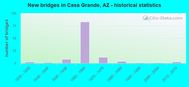
- New bridges - historical statistics
- 31930-1939
- 21940-1949
- 81950-1959
- 831960-1969
- 121970-1979
- 41980-1989
- 11990-1999
- 12000-2009
- 32010-2019

- Reconstructed bridges - Historical Statistics
- 61960-1969
- 81970-1979
- 41980-1989
- 11990-1999
- 102000-2009


- Bridge Condition - Deck
- 3.4%Very good
- 17.2%Good
- 75.9%Satisfactory
- 3.4%Fair

- Bridge Condition - Superstructure
- 6.5%Very good
- 61.3%Good
- 22.6%Satisfactory
- 9.7%Fair

- Bridge Condition - Substructure
- 3.2%Very good
- 51.6%Good
- 41.9%Satisfactory
- 3.2%Fair

- Bridge Condition - Channel
- 16.5%Very good
- 59.5%Good
- 24.1%Satisfactory

- Bridge Condition - Culverts
- 3.1%Very good
- 84.4%Good
- 12.5%Satisfactory
Find on map >> Show street view
Structure Number: 10921, Location: 0.9 mi E Jct I-10 (Lat: 32.938061, Lng: -111.686056), Route carried "on" structure: County highway , Year Built: 2008, Status: Open, Structure Length: 1.65m (5.41ft), Average Daily Traffic: 5,964 (year 2010), Truck Traffic: 5%, Average Future Daily Traffic: 5,974 (year 2035), Design Load: HS 20, Features Intersected: Wash, Facility Carried by Structure: McCartney Road
Minimum Vertical Clearance: 30+ m (98+ ft), Kilometerpoint: 0.000, Lanes on structure: 2, Owner: County Highway Agency, Approaching Roadway Width: 12.2m (40.0ft), Material/Design: Concrete continuous, Design/Construction: Culvert, Number Of Spans In Main Unit: 5, Length of Maximum Span: 3.0m (9.8ft), Curb-To-Curb Width: 12.8m (42.0ft), Out-to-Out Width: 16.5m (54.1ft)
Condition: Channel: Good, Culverts: Very good, Operating Rating: 52.6 metric tons, Method Used To Determine Operating Rating: Load Factor (LF), Inventory Rating: 31.8 metric tons, Method Used To Determine Inventory Rating: Load Factor (LF), Structural Evaluation: Better than present minimum criteria, Deck Geometry: Somewhat better than minimum adequacy, Waterway Adequacy: Better than present minimum criteria, Approach Roadway Alignment: Better than present minimum criteria, Designated Inspection Frequency: Every 48 months, Inspection Date: November 2019, Deck Structure Type: Concrete Cast-file-Place, Wearing Surface/Protective System: Wearing Surface: Bituminous
Find on map >> Show street view
Structure Number: 11334, Location: 5.1 mi E Jct SR 387 (Lat: 32.834300, Lng: -111.687600), Route carried "on" structure: City street , Year Built: 1960, Year Reconstructed: 1966, Status: Open, Structure Length: 0.76m (2.49ft), Average Daily Traffic: 9,000 (year 2018), Truck Traffic: 11%, Average Future Daily Traffic: 9,010 (year 2038), Design Load: HS 20, Features Intersected: Wash, Facility Carried by Structure: Jimmie Kerr Blvd
Minimum Vertical Clearance: 30+ m (98+ ft), Kilometerpoint: 0.000, Lanes on structure: 3, Owner: City or Municipal Highway Agency, Approaching Roadway Width: 17.1m (56.1ft), Material/Design: Concrete continuous, Design/Construction: Culvert, Number Of Spans In Main Unit: 3, Length of Maximum Span: 3.0m (9.8ft)
Condition: Channel: Satisfactory, Culverts: Good, Operating Rating: 89.8 metric tons, Method Used To Determine Operating Rating: Load Factor (LF), Inventory Rating: 78.0 metric tons, Method Used To Determine Inventory Rating: Load Factor (LF), Structural Evaluation: Better than present minimum criteria, Waterway Adequacy: Better than present minimum criteria, Approach Roadway Alignment: Equal to present desirable criteria, Designated Inspection Frequency: Every 48 months, Inspection Date: November 2019
Find on map >> Show street view
Structure Number: 11629, Location: 0.3 mi E Jct I-10 (Lat: 32.938100, Lng: -111.695000), Route carried "on" structure: County highway , Year Built: 2018, Status: Open, Structure Length: 1.46m (4.79ft), Average Daily Traffic: 5,000 (year 2019), Truck Traffic: 5%, Average Future Daily Traffic: 5,010 (year 2039), Design Load: HS 20, Features Intersected: Wash, Facility Carried by Structure: McCartney Rd
Minimum Vertical Clearance: 30.45m (99.90ft), Kilometerpoint: 0.000, Lanes on structure: 2, Owner: County Highway Agency, Approaching Roadway Width: 8.5m (27.9ft), Material/Design: Steel, Design/Construction: Culvert, Number Of Spans In Main Unit: 6, Length of Maximum Span: 1.2m (3.9ft)
Condition: Channel: Very good, Culverts: Very good, Operating Rating: 89.8 metric tons, Method Used To Determine Operating Rating: Load Factor (LF), Inventory Rating: 82.6 metric tons, Method Used To Determine Inventory Rating: Load Factor (LF), Structural Evaluation: Equal to present desirable criteria, Waterway Adequacy: Equal to present desirable criteria, Approach Roadway Alignment: Equal to present desirable criteria, Designated Inspection Frequency: Every 48 months, Inspection Date: November 2019
Find on map >> Show street view
Structure Number: 20049, Location: 1 mile N Jct of I 8 (Lat: 32.833700, Lng: -111.685800), Route carried "on" structure: Interstate 10, Year Built: 2018, Status: Open, Structure Length: 18.65m (61.19ft), Average Daily Traffic: 45,481 (year 2018), Truck Traffic: 19%, Average Future Daily Traffic: 45,491 (year 2038), Design Load: HL 93, Features Intersected: Jimmie Kerr Blvd & UPRR
Minimum Vertical Clearance: 30+ m (98+ ft), Kilometerpoint: 318.972, Lanes on structure: 8, Lanes under structure: 2, Owner: State Highway Agency, Approaching Roadway Width: 43.9m (144.0ft), Skew: 34 degrees, Material/Design: Prestressed concrete continuous, Design/Construction: Stringer/Multi-beam, Number Of Spans In Main Unit: 4, Length of Maximum Span: 46.9m (153.9ft), Curb-To-Curb Width: 43.9m (144.0ft), Out-to-Out Width: 45.7m (149.9ft)
Condition: Deck: Very good, Superstructure: Very good, Substructure: Very good, Channel: Very good, Operating Rating: 89.8 metric tons, Method Used To Determine Operating Rating: Load Factor (LF), Inventory Rating: 43.5 metric tons, Method Used To Determine Inventory Rating: Load Factor (LF), Structural Evaluation: Equal to present desirable criteria, Deck Geometry: Superior to present desirable criteria, Underclear: High priority of corrective action, Waterway Adequacy: Equal to present desirable criteria, Approach Roadway Alignment: Equal to present desirable criteria, Designated Inspection Frequency: Every 24 months, Inspection Date: November 2020, Deck Structure Type: Concrete Cast-file-Place, Wearing Surface/Protective System: Wearing Surface: Monolithic Concrete
Find on map >> Show street view
Structure Number: 143, Location: 22.5 mi E Jct I-8 (Lat: 32.879800, Lng: -111.762000), Route carried "under" structure: State highway 84, Year Built: 1936, Structure Length: 0. m, Average Daily Traffic: 4,254 (year 2018), Truck Traffic: 9%, Features Intersected: SR 84 EB; FAU 9504, Facility Carried by Structure: SPRR
Minimum Vertical Clearance: 4.34m (14.24ft), Kilometerpoint: 285.916, Lanes under structure: 2, Material/Design: Concrete continuous, Design/Construction: Frame, Length of Maximum Span: 8.2m (26.9ft)
Find on map >> Show street view
Structure Number: 1062, Location: 22.5 mi E Jct I-8 (Lat: 32.879900, Lng: -111.762100), Route carried "under" structure: State highway 84, Year Built: 1963, Structure Length: 0. m, Average Daily Traffic: 4,909 (year 2018), Truck Traffic: 9%, Features Intersected: SR 84 WB; FAU 9504, Facility Carried by Structure: SPRR
Minimum Vertical Clearance: 4.36m (14.30ft), Kilometerpoint: 285.916, Lanes under structure: 2, Material/Design: Concrete, Design/Construction: Frame, Length of Maximum Span: 9.8m (32.2ft)
Find on map >> Show street view
Structure Number: 1094, Location: 12.8 E Jct SR 84 (Lat: 32.827800, Lng: -111.912000), Route carried "under" structure: Interstate 8, Year Built: 1965, Structure Length: 0. m, Average Daily Traffic: 7,225 (year 2019), Truck Traffic: 35%, Features Intersected: I 8, Facility Carried by Structure: Russell Rd
Minimum Vertical Clearance: 5.10m (16.73ft), Kilometerpoint: 264.737, Lanes on structure: 2, Lanes under structure: 2, Material/Design: Steel continuous, Design/Construction: Stringer/Multi-beam, Length of Maximum Span: 23.8m (78.1ft)
Find on map >> Show street view
Structure Number: 1102, Location: At Jct of I 10 (Lat: 32.819400, Lng: -111.683900), Route carried "under" structure: Interstate 10, Year Built: 1966, Structure Length: 0. m, Average Daily Traffic: 49,665 (year 2019), Truck Traffic: 19%, Features Intersected: I 10, Facility Carried by Structure: I 8; WB
Minimum Vertical Clearance: 5.34m (17.52ft), Kilometerpoint: 320.420, Lanes on structure: 2, Lanes under structure: 7, Material/Design: Steel continuous, Design/Construction: Stringer/Multi-beam, Length of Maximum Span: 27.7m (90.9ft)
Find on map >> Show street view
Structure Number: 1103, Location: At Jct of I 10 (Lat: 32.819300, Lng: -111.683800), Route carried "under" structure: Interstate 10, Year Built: 1966, Structure Length: 0. m, Average Daily Traffic: 49,665 (year 2019), Truck Traffic: 19%, Features Intersected: I 10, Facility Carried by Structure: I 8; EB Ramp
Minimum Vertical Clearance: 5.19m (17.03ft), Kilometerpoint: 320.436, Lanes on structure: 1, Lanes under structure: 7, Material/Design: Steel continuous, Design/Construction: Stringer/Multi-beam, Length of Maximum Span: 27.7m (90.9ft)
Find on map >> Show street view
Structure Number: 1137, Location: 14.8 E Jct SR 84 (Lat: 32.827700, Lng: -111.877600), Route carried "under" structure: Interstate 8, Year Built: 1966, Structure Length: 0. m, Average Daily Traffic: 7,225 (year 2019), Truck Traffic: 35%, Features Intersected: I 8, Facility Carried by Structure: Midway Rd
Minimum Vertical Clearance: 5.30m (17.39ft), Kilometerpoint: 267.956, Lanes on structure: 2, Lanes under structure: 2, Material/Design: Steel continuous, Design/Construction: Stringer/Multi-beam, Length of Maximum Span: 23.8m (78.1ft)
Find on map >> Show street view
Structure Number: 114, Location: 10.8 mi W of Jct I-10 (Lat: 32.827700, Lng: -111.860500), Route carried "under" structure: Interstate 8, Year Built: 1966, Structure Length: 0. m, Average Daily Traffic: 7,225 (year 2019), Truck Traffic: 35%, Features Intersected: I 8, Facility Carried by Structure: FAS 472;Montgomery
Minimum Vertical Clearance: 5.18m (16.99ft), Kilometerpoint: 269.565, Lanes on structure: 2, Lanes under structure: 2, Material/Design: Steel continuous, Design/Construction: Stringer/Multi-beam, Length of Maximum Span: 23.8m (78.1ft)
Find on map >> Show street view
Structure Number: 1141, Location: 8.8 mi W Jct I10 (Lat: 32.827700, Lng: -111.826000), Route carried "under" structure: Interstate 8, Year Built: 1967, Structure Length: 0. m, Average Daily Traffic: 7,298 (year 2019), Truck Traffic: 33%, Features Intersected: I 8, Facility Carried by Structure: FAS 471;Bianco Rd
Minimum Vertical Clearance: 5.16m (16.93ft), Kilometerpoint: 272.848, Lanes on structure: 2, Lanes under structure: 2, Material/Design: Steel continuous, Design/Construction: Stringer/Multi-beam, Length of Maximum Span: 23.8m (78.1ft)
Find on map >> Show street view
Structure Number: 1151, Location: 9.5 mi SE Jct SR 587 (Lat: 33.002700, Lng: -111.753200), Route carried "under" structure: Interstate 10, Year Built: 1967, Structure Length: 0. m, Average Daily Traffic: 61,214 (year 2018), Truck Traffic: 19%, Features Intersected: I-10, Facility Carried by Structure: IRR SR 387
Minimum Vertical Clearance: 5.13m (16.83ft), Kilometerpoint: 298.147, Lanes on structure: 2, Lanes under structure: 2, Material/Design: Steel continuous, Design/Construction: Stringer/Multi-beam, Length of Maximum Span: 27.4m (89.9ft)
Find on map >> Show street view
Structure Number: 1152, Location: 10.9 mi NW Jct I-8 (Lat: 32.967500, Lng: -111.724900), Route carried "under" structure: Interstate 10, Year Built: 1966, Structure Length: 0. m, Average Daily Traffic: 41,860 (year 2018), Truck Traffic: 19%, Features Intersected: I-10, Facility Carried by Structure: IRR Val Vista Blvd
Minimum Vertical Clearance: 5.25m (17.22ft), Kilometerpoint: 302.879, Lanes on structure: 2, Lanes under structure: 2, Material/Design: Steel continuous, Design/Construction: Stringer/Multi-beam, Length of Maximum Span: 28.7m (94.2ft)
Find on map >> Show street view
Structure Number: 1153, Location: 8.4 mi W Jct I-8 (Lat: 32.938200, Lng: -111.701400), Route carried "under" structure: Interstate 10, Year Built: 1968, Structure Length: 0. m, Average Daily Traffic: 41,860 (year 2018), Truck Traffic: 19%, Features Intersected: I-10, Facility Carried by Structure: IRR McCartney Road
Minimum Vertical Clearance: 5.11m (16.77ft), Kilometerpoint: 306.950, Lanes on structure: 2, Lanes under structure: 2, Material/Design: Steel continuous, Design/Construction: Stringer/Multi-beam, Length of Maximum Span: 29.6m (97.1ft)
Find on map >> Show street view
Structure Number: 1154, Location: 5.2 mi N Jct I-8 (Lat: 32.894200, Lng: -111.687300), Route carried "under" structure: Interstate 10, Year Built: 1966, Structure Length: 0. m, Average Daily Traffic: 42,837 (year 2018), Truck Traffic: 19%, Features Intersected: I-10, Facility Carried by Structure: Cottonwood Lane
Minimum Vertical Clearance: 5.00m (16.40ft), Kilometerpoint: 312.020, Lanes on structure: 2, Lanes under structure: 2, Material/Design: Steel continuous, Design/Construction: Stringer/Multi-beam, Length of Maximum Span: 23.8m (78.1ft)
Find on map >> Show street view
Structure Number: 1156, Location: 4.2 mi N Jct I-8 (Lat: 32.879700, Lng: -111.687300), Route carried "under" structure: Interstate 10, Year Built: 1966, Structure Length: 0. m, Average Daily Traffic: 42,837 (year 2018), Truck Traffic: 19%, Features Intersected: I-10, Facility Carried by Structure: SR 287
Minimum Vertical Clearance: 5.10m (16.73ft), Kilometerpoint: 313.629, Lanes on structure: 6, Lanes under structure: 6, Material/Design: Steel continuous, Design/Construction: Stringer/Multi-beam, Length of Maximum Span: 23.8m (78.1ft)
Find on map >> Show street view
Structure Number: 1158, Location: 03.2 mi W Jct I 8 (Lat: 32.865100, Lng: -111.687500), Route carried "under" structure: Interstate 10, Year Built: 1966, Structure Length: 0. m, Average Daily Traffic: 44,488 (year 2018), Truck Traffic: 19%, Features Intersected: I 10, Facility Carried by Structure: Earley Rd
Minimum Vertical Clearance: 5.04m (16.54ft), Kilometerpoint: 315.254, Lanes on structure: 2, Lanes under structure: 2, Material/Design: Steel continuous, Design/Construction: Stringer/Multi-beam, Length of Maximum Span: 23.8m (78.1ft)
Find on map >> Show street view
Structure Number: 116, Location: 02.2 mi W Jct I 8 (Lat: 32.850500, Lng: -111.687600), Route carried "under" structure: Interstate 10, Year Built: 1966, Structure Length: 0. m, Average Daily Traffic: 44,488 (year 2018), Truck Traffic: 19%, Features Intersected: I 10; EB & WB, Facility Carried by Structure: Selma Hwy
Minimum Vertical Clearance: 5.24m (17.19ft), Kilometerpoint: 316.864, Lanes on structure: 2, Lanes under structure: 2, Material/Design: Steel continuous, Design/Construction: Stringer/Multi-beam, Length of Maximum Span: 24.1m (79.1ft)
Find on map >> Show street view
Structure Number: 1196, Location: 5.8 mi W Jct I10 (Lat: 32.827700, Lng: -111.774300), Route carried "under" structure: Interstate 8, Year Built: 1967, Structure Length: 0. m, Average Daily Traffic: 8,604 (year 2019), Truck Traffic: 28%, Features Intersected: I 8, Facility Carried by Structure: Thornton Road
Minimum Vertical Clearance: 4.93m (16.17ft), Kilometerpoint: 277.692, Lanes on structure: 2, Lanes under structure: 2, Material/Design: Steel continuous, Design/Construction: Stringer/Multi-beam, Length of Maximum Span: 24.7m (81.0ft)
Find on map >> Show street view
Structure Number: 1197, Location: 4.8 mi W of Jct I10 (Lat: 32.827700, Lng: -111.757400), Route carried "under" structure: Interstate 8, Year Built: 1967, Structure Length: 0. m, Average Daily Traffic: 8,604 (year 2019), Truck Traffic: 28%, Features Intersected: I8, Facility Carried by Structure: Chuichu Rd
Minimum Vertical Clearance: 5.02m (16.47ft), Kilometerpoint: 279.269, Lanes on structure: 2, Lanes under structure: 2, Material/Design: Steel continuous, Design/Construction: Stringer/Multi-beam, Length of Maximum Span: 23.8m (78.1ft)
Find on map >> Show street view
Structure Number: 1198, Location: 3.8 mi W of Jct I10 (Lat: 32.828100, Lng: -111.740100), Route carried "under" structure: Interstate 8, Year Built: 1967, Structure Length: 0. m, Average Daily Traffic: 8,604 (year 2019), Truck Traffic: 28%, Features Intersected: I8, Facility Carried by Structure: Trekell Rd
Minimum Vertical Clearance: 5.19m (17.03ft), Kilometerpoint: 280.911, Lanes on structure: 2, Lanes under structure: 2, Material/Design: Steel continuous, Design/Construction: Stringer/Multi-beam, Length of Maximum Span: 24.4m (80.1ft)
Find on map >> Show street view
Structure Number: 1199, Location: 2.7 mi W Jct I-10 (Lat: 32.834800, Lng: -111.722900), Route carried "under" structure: County highway , Year Built: 1967, Structure Length: 0. m, Average Daily Traffic: 100 (year 2020), Truck Traffic: 5%, Features Intersected: Peart Rd, Facility Carried by Structure: I-8 EB
Minimum Vertical Clearance: 4.53m (14.86ft), Kilometerpoint: 0.000, Lanes on structure: 2, Lanes under structure: 2, Material/Design: Concrete continuous, Design/Construction: Slab, Length of Maximum Span: 10.7m (35.1ft)
Find on map >> Show street view
Structure Number: 12, Location: 2.7 mi W Jct I-10 (Lat: 32.835100, Lng: -111.722900), Route carried "under" structure: County highway , Year Built: 1967, Structure Length: 0. m, Average Daily Traffic: 100 (year 2020), Truck Traffic: 5%, Features Intersected: Peart Rd, Facility Carried by Structure: I-8 WB
Minimum Vertical Clearance: 4.88m (16.01ft), Kilometerpoint: 0.000, Lanes on structure: 2, Lanes under structure: 2, Material/Design: Concrete continuous, Design/Construction: Slab, Length of Maximum Span: 10.7m (35.1ft)
Find on map >> Show street view
Structure Number: 2078, Location: 6.4 mi West of Jct SR 85 (Lat: 32.943900, Lng: -111.705400), Route carried "under" structure: Interstate 10, Year Built: 1988, Structure Length: 0. m, Average Daily Traffic: 42,875 (year 2018), Truck Traffic: 28%, Features Intersected: I 10, Facility Carried by Structure: Palo Verde Road
Minimum Vertical Clearance: 5.23m (17.16ft), Kilometerpoint: 176.513, Lanes on structure: 6, Lanes under structure: 6, Material/Design: Prestressed concrete continuous, Design/Construction: Stringer/Multi-beam, Length of Maximum Span: 40.5m (132.9ft)
Find on map >> Show street view
Structure Number: 20049, Location: 1 mile N Jct of I 8 (Lat: 32.833700, Lng: -111.685800), Route carried "under" structure: State highway 84, Year Built: 2018, Structure Length: 0. m, Average Daily Traffic: 10,154 (year 2019), Features Intersected: Jimmie Kerr Blvd & UPRR, Facility Carried by Structure: I-10
Minimum Vertical Clearance: 9.14m (29.99ft), Kilometerpoint: 294.896, Lanes on structure: 8, Lanes under structure: 2, Material/Design: Prestressed concrete continuous, Design/Construction: Stringer/Multi-beam, Length of Maximum Span: 46.9m (153.9ft)