Bridge Statistics for Cartersville, Georgia (GA)
Condition, Traffic, Stress, Structural Evaluation, Project Costs
- National Bridge Inventory (NBI) Statistics
- 98Number of bridges
- 1,040ft / 317mTotal length
- $297,446,000Total costs
- 1,463,893Total average daily traffic
- 62,349Total average daily truck traffic
- National Bridge Inventory (NBI) Registered Bridges for Cartersville
- No street view available for this location
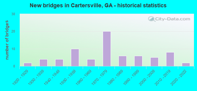
- New bridges - historical statistics
- 21920-1929
- 41930-1939
- 41940-1949
- 101950-1959
- 41960-1969
- 201970-1979
- 61980-1989
- 61990-1999
- 52000-2009
- 82010-2019
- 22020-2022

- Reconstructed bridges - Historical Statistics
- 11950-1959
- 51960-1969
- 21970-1979
- 31980-1989
- 61990-1999


- Bridge Condition - Deck
- 10.4%Very good
- 72.9%Good
- 4.2%Satisfactory
- 12.5%Fair

- Bridge Condition - Superstructure
- 16.7%Very good
- 60.4%Good
- 12.5%Satisfactory
- 8.3%Fair
- 2.1%Poor

- Bridge Condition - Substructure
- 6.3%Very good
- 64.6%Good
- 18.8%Satisfactory
- 10.4%Fair

- Bridge Condition - Channel
- 6.4%Excellent
- 48.9%Very good
- 14.9%Good
- 23.4%Satisfactory
- 6.4%Fair

- Bridge Condition - Culverts
- 73.9%Good
- 13.0%Satisfactory
- 13.0%Fair
Find on map >> Show street view
Structure Number: 15012, Location: 12.3 MI SE OF BAXLEY (Lat: 31.610639, Lng: -82.273819), Route carried "on" structure: County highway 177, Year Built: 1976, Status: Open, Structure Length: 9.75m (31.99ft), Average Daily Traffic: 70 (year 2011), Truck Traffic: 1%, Average Future Daily Traffic: 105 (year 2031), Design Load: H 15, Features Intersected: SWEETWATER CREEK, Facility Carried by Structure: REESE ROAD
Minimum Vertical Clearance: 30+ m (98+ ft), Kilometerpoint: 3.219, Lanes on structure: 2, Base Highway Network: Yes, Owner: County Highway Agency, Approaching Roadway Width: 6.1m (20.0ft), Material/Design: Prestressed concrete, Design/Construction: Channel Beam, Number Of Spans In Main Unit: 16, Length of Maximum Span: 6.1m (20.0ft), Curb-To-Curb Width: 7.4m (24.3ft), Out-to-Out Width: 7.8m (25.6ft)
Condition: Deck: Good, Superstructure: Good, Substructure: Good, Channel: Very good, Operating Rating: 46.2 metric tons, Method Used To Determine Operating Rating: Load Factor (LF), Inventory Rating: 27.2 metric tons, Method Used To Determine Inventory Rating: Load Factor (LF), Structural Evaluation: Equal to present minimum criteria, Deck Geometry: Equal to present minimum criteria, Waterway Adequacy: Better than present minimum criteria, Approach Roadway Alignment: Equal to present desirable criteria, Designated Inspection Frequency: Every 24 months, Underwater Inspection Frequency: Every 60 months, Inspection Date: January 2021, Underwater Inspection Date: June 2020, Bridge Improvement Cost: $1,250,000, Roadway Improvement Cost: $125,000, Total Project Cost: $1,875,000, Deck Structure Type: Concrete Precast Panels
Find on map >> Show street view
Structure Number: 150008, Location: 1.3 MI SE OF CARTERSVILLE (Lat: 34.154119, Lng: -84.780239), Route carried "on" structure: US 41, Year Built: 1953, Status: Open, Structure Length: 0.82m (2.69ft), Average Daily Traffic: 16,290 (year 2011), Truck Traffic: 1%, Average Future Daily Traffic: 24,435 (year 2031), Design Load: H 20, Features Intersected: CSX RR SPUR (340433T)
Minimum Vertical Clearance: 30+ m (98+ ft), Kilometerpoint: 11.265, Lanes on structure: 4, Base Highway Network: Yes, Owner: State Highway Agency, Approaching Roadway Width: 18.3m (60.0ft), Skew: 14 degrees, Material/Design: Concrete, Design/Construction: Frame, Number Of Spans In Main Unit: 1, Length of Maximum Span: 8.2m (26.9ft), Curb-To-Curb Width: 18.3m (60.0ft), Out-to-Out Width: 18.3m (60.0ft)
Condition: Deck: Satisfactory, Superstructure: Satisfactory, Substructure: Satisfactory, Operating Rating: 89.8 metric tons, Method Used To Determine Operating Rating: Allowable Stress (AS), Inventory Rating: 29.9 metric tons, Method Used To Determine Inventory Rating: Allowable Stress (AS), Structural Evaluation: Equal to present minimum criteria, Deck Geometry: Somewhat better than minimum adequacy, Approach Roadway Alignment: Equal to present desirable criteria, Designated Inspection Frequency: Every 24 months, Inspection Date: October 2020, Bridge Improvement Cost: $163,000, Roadway Improvement Cost: $16,000, Total Project Cost: $245,000, Deck Structure Type: Concrete Cast-file-Place, Wearing Surface/Protective System: Wearing Surface: Bituminous
Find on map >> Show street view
Structure Number: 150015, Location: 4.5 MI NW OF CARTERSVILLE (Lat: 34.219289, Lng: -84.844328), Route carried "on" structure: US 41, Year Built: 1952, Status: Open, Structure Length: 0.98m (3.22ft), Average Daily Traffic: 43,290 (year 2011), Truck Traffic: 6%, Average Future Daily Traffic: 64,935 (year 2031), Design Load: H 15, Features Intersected: NANCY CREEK
Minimum Vertical Clearance: 30+ m (98+ ft), Kilometerpoint: 22.531, Lanes on structure: 5, Base Highway Network: Yes, Owner: State Highway Agency, Approaching Roadway Width: 8.2m (26.9ft), Skew: 11 degrees, Material/Design: Concrete, Design/Construction: Culvert, Number Of Spans In Main Unit: 3, Length of Maximum Span: 3.0m (9.8ft)
Condition: Channel: Very good, Culverts: Good, Operating Rating: 67.1 metric tons, Method Used To Determine Operating Rating: Load Factor (LF), Inventory Rating: 39.9 metric tons, Method Used To Determine Inventory Rating: Load Factor (LF), Structural Evaluation: Better than present minimum criteria, Waterway Adequacy: Superior to present desirable criteria, Approach Roadway Alignment: Equal to present desirable criteria, Designated Inspection Frequency: Every 24 months, Inspection Date: August 2020, Bridge Improvement Cost: $227,000, Roadway Improvement Cost: $23,000, Total Project Cost: $341,000
Find on map >> Show street view
Structure Number: 150016, Location: 4.7 MI NW OF CARTERSVILLE (Lat: 34.221078, Lng: -84.850547), Route carried "on" structure: US 41, Year Built: 1952, Year Reconstructed: 1960, Status: Open, Structure Length: 6.49m (21.29ft), Average Daily Traffic: 11,600 (year 2011), Truck Traffic: 1%, Average Future Daily Traffic: 17,400 (year 2031), Design Load: HS 20, Features Intersected: SR 20 (US 411)
Minimum Vertical Clearance: 30+ m (98+ ft), Kilometerpoint: 24.140, Lanes on structure: 2, Lanes under structure: 3, Base Highway Network: Yes, Owner: State Highway Agency, Approaching Roadway Width: 9.1m (29.9ft), Skew: 12 degrees, Material/Design: Steel, Design/Construction: Stringer/Multi-beam, Number Of Spans In Main Unit: 5, Length of Maximum Span: 17.4m (57.1ft), Curb or Sidewalk Widths: Left: 0.7m (2.3ft), Right: 0.7m (2.3ft), Curb-To-Curb Width: 8.5m (27.9ft), Out-to-Out Width: 10.4m (34.1ft)
Condition: Deck: Fair, Superstructure: Satisfactory, Substructure: Fair, Operating Rating: 31.7 metric tons, Method Used To Determine Operating Rating: Load Factor (LF), Inventory Rating: 19.0 metric tons, Method Used To Determine Inventory Rating: Load Factor (LF), Structural Evaluation: Meets minimum limits, Deck Geometry: High priority of corrective action, Underclear: Somewhat better than minimum adequacy, Approach Roadway Alignment: Equal to present desirable criteria, Designated Inspection Frequency: Every 24 months, Inspection Date: October 2020, Bridge Improvement Cost: $832,000, Roadway Improvement Cost: $83,000, Total Project Cost: $1,248,000, Deck Structure Type: Concrete Cast-file-Place, Wearing Surface/Protective System: Wearing Surface: Bituminous
Find on map >> Show street view
Structure Number: 150017, Location: 4.7 MI NW OF CARTERSVILLE (Lat: 34.220989, Lng: -84.850769), Route carried "on" structure: US 41, Year Built: 1952, Year Reconstructed: 1960, Status: Open, Structure Length: 6.43m (21.10ft), Average Daily Traffic: 11,600 (year 2011), Truck Traffic: 1%, Average Future Daily Traffic: 17,400 (year 2031), Design Load: HS 20, Features Intersected: SR 20 (US 411)
Minimum Vertical Clearance: 30+ m (98+ ft), Kilometerpoint: 24.140, Lanes on structure: 2, Lanes under structure: 3, Base Highway Network: Yes, Owner: State Highway Agency, Approaching Roadway Width: 9.1m (29.9ft), Skew: 12 degrees, Material/Design: Steel, Design/Construction: Stringer/Multi-beam, Number Of Spans In Main Unit: 5, Length of Maximum Span: 17.4m (57.1ft), Curb or Sidewalk Widths: Left: 0.7m (2.3ft), Right: 0.7m (2.3ft), Curb-To-Curb Width: 8.5m (27.9ft), Out-to-Out Width: 10.4m (34.1ft)
Condition: Deck: Fair, Superstructure: Good, Substructure: Fair, Operating Rating: 37.1 metric tons, Method Used To Determine Operating Rating: Load Factor (LF), Inventory Rating: 22.6 metric tons, Method Used To Determine Inventory Rating: Load Factor (LF), Structural Evaluation: Somewhat better than minimum adequacy, Deck Geometry: High priority of corrective action, Underclear: Somewhat better than minimum adequacy, Approach Roadway Alignment: Equal to present desirable criteria, Designated Inspection Frequency: Every 24 months, Inspection Date: October 2020, Bridge Improvement Cost: $824,000, Roadway Improvement Cost: $82,000, Total Project Cost: $1,237,000, Deck Structure Type: Concrete Cast-file-Place
Find on map >> Show street view
Structure Number: 150018, Location: 1 MI N OF CASSVILLE (Lat: 34.261558, Lng: -84.860519), Route carried "on" structure: US 41, Year Built: 1949, Status: Open, Structure Length: 4.57m (14.99ft), Average Daily Traffic: 6,860 (year 2011), Truck Traffic: 1%, Average Future Daily Traffic: 10,290 (year 2031), Design Load: H 15, Features Intersected: TWO RUN CREEK
Minimum Vertical Clearance: 30+ m (98+ ft), Kilometerpoint: 28.968, Lanes on structure: 2, Base Highway Network: Yes, Owner: State Highway Agency, Approaching Roadway Width: 8.5m (27.9ft), Skew: 3 degrees, Material/Design: Concrete, Design/Construction: Tee Beam, Number Of Spans In Main Unit: 5, Length of Maximum Span: 9.1m (29.9ft), Curb or Sidewalk Widths: Left: 0.7m (2.3ft), Right: 0.7m (2.3ft), Curb-To-Curb Width: 9.1m (29.9ft), Out-to-Out Width: 11.0m (36.1ft)
Condition: Deck: Fair, Superstructure: Good, Substructure: Fair, Channel: Satisfactory, Operating Rating: 39.9 metric tons, Method Used To Determine Operating Rating: Load Factor (LF), Inventory Rating: 23.5 metric tons, Method Used To Determine Inventory Rating: Load Factor (LF), Structural Evaluation: Somewhat better than minimum adequacy, Deck Geometry: High priority of corrective action, Waterway Adequacy: Superior to present desirable criteria, Approach Roadway Alignment: Equal to present desirable criteria, Length Of Structure Improvement: 11.00m (36.09ft), Designated Inspection Frequency: Every 24 months, Inspection Date: September 2020, Bridge Improvement Cost: $586,000, Roadway Improvement Cost: $59,000, Total Project Cost: $879,000, Deck Structure Type: Concrete Cast-file-Place
Find on map >> Show street view
Structure Number: 150026, Location: 4.8 MI NW OF CARTERSVILLE (Lat: 34.219408, Lng: -84.853619), Route carried "on" structure: US 411, Year Built: 1959, Year Reconstructed: 2002, Status: Open, Structure Length: 9.75m (31.99ft), Average Daily Traffic: 15,480 (year 2011), Truck Traffic: 12%, Average Future Daily Traffic: 23,220 (year 2031), Design Load: HS 20+Mod, Features Intersected: SR 293- CSX RR (340459V)
Minimum Vertical Clearance: 30+ m (98+ ft), Kilometerpoint: 17.703, Lanes on structure: 2, Lanes under structure: 2, Base Highway Network: Yes, Owner: State Highway Agency, Approaching Roadway Width: 9.1m (29.9ft), Skew: 13 degrees, Material/Design: Steel, Design/Construction: Stringer/Multi-beam, Number Of Spans In Main Unit: 6, Length of Maximum Span: 17.1m (56.1ft), Curb-To-Curb Width: 11.4m (37.4ft), Out-to-Out Width: 12.3m (40.4ft)
Condition: Deck: Good, Superstructure: Good, Substructure: Good, Operating Rating: 31.7 metric tons, Method Used To Determine Operating Rating: Load Factor (LF), Inventory Rating: 19.0 metric tons, Method Used To Determine Inventory Rating: Load Factor (LF), Structural Evaluation: Meets minimum limits, Deck Geometry: Equal to present minimum criteria, Underclear: High priority of corrective action, Approach Roadway Alignment: Equal to present desirable criteria, Designated Inspection Frequency: Every 24 months, Inspection Date: October 2020, Bridge Improvement Cost: $1,250,000, Roadway Improvement Cost: $125,000, Total Project Cost: $1,875,000, Deck Structure Type: Concrete Cast-file-Place, Wearing Surface/Protective System: Wearing Surface: Epoxy Overlay
Find on map >> Show street view
Structure Number: 150027, Location: 4.8 MI NW OF CARTERSVILLE (Lat: 34.219519, Lng: -84.853819), Route carried "on" structure: US 411, Year Built: 1959, Year Reconstructed: 2002, Status: Open, Structure Length: 9.75m (31.99ft), Average Daily Traffic: 15,480 (year 2011), Truck Traffic: 12%, Average Future Daily Traffic: 23,220 (year 2031), Design Load: HS 20+Mod, Features Intersected: SR 293- CSX RR (340459V)
Minimum Vertical Clearance: 30+ m (98+ ft), Kilometerpoint: 17.703, Lanes on structure: 2, Lanes under structure: 2, Base Highway Network: Yes, Owner: State Highway Agency, Approaching Roadway Width: 9.1m (29.9ft), Skew: 13 degrees, Material/Design: Steel, Design/Construction: Stringer/Multi-beam, Number Of Spans In Main Unit: 6, Length of Maximum Span: 17.1m (56.1ft), Curb-To-Curb Width: 12.6m (41.3ft), Out-to-Out Width: 13.5m (44.3ft)
Condition: Deck: Good, Superstructure: Very good, Substructure: Good, Operating Rating: 33.5 metric tons, Method Used To Determine Operating Rating: Load Factor (LF), Inventory Rating: 19.9 metric tons, Method Used To Determine Inventory Rating: Load Factor (LF), Structural Evaluation: Somewhat better than minimum adequacy, Deck Geometry: Better than present minimum criteria, Underclear: Meets minimum limits, Approach Roadway Alignment: Equal to present desirable criteria, Designated Inspection Frequency: Every 24 months, Inspection Date: October 2020, Bridge Improvement Cost: $1,250,000, Roadway Improvement Cost: $125,000, Total Project Cost: $1,875,000, Deck Structure Type: Concrete Cast-file-Place, Wearing Surface/Protective System: Wearing Surface: Epoxy Overlay
Find on map >> Show street view
Structure Number: 150028, Location: 5 MI SE OF WHITE (Lat: 34.221600, Lng: -84.701289), Route carried "on" structure: State highway 20, Year Built: 1954, Status: Open, Structure Length: 0.88m (2.89ft), Average Daily Traffic: 13,260 (year 2011), Truck Traffic: 1%, Average Future Daily Traffic: 19,890 (year 2031), Design Load: H 15, Features Intersected: MCKASKY CREEK
Minimum Vertical Clearance: 30+ m (98+ ft), Kilometerpoint: 33.796, Lanes on structure: 3, Base Highway Network: Yes, Owner: State Highway Agency, Approaching Roadway Width: 7.3m (24.0ft), Skew: 4 degrees, Material/Design: Concrete, Design/Construction: Culvert, Number Of Spans In Main Unit: 2, Length of Maximum Span: 4.3m (14.1ft)
Condition: Channel: Good, Culverts: Good, Structural Evaluation: Better than present minimum criteria, Waterway Adequacy: Superior to present desirable criteria, Approach Roadway Alignment: Equal to present desirable criteria, Designated Inspection Frequency: Every 24 months, Inspection Date: July 2020, Bridge Improvement Cost: $113,000, Roadway Improvement Cost: $11,000, Total Project Cost: $170,000
Find on map >> Show street view
Structure Number: 150034, Location: IN SW CARTERSVILLE (Lat: 34.148389, Lng: -84.829978), Route carried "on" structure: State highway 61, Year Built: 1947, Year Reconstructed: 1990, Status: Open, Structure Length: 5.03m (16.50ft), Average Daily Traffic: 7,286 (year 2011), Truck Traffic: 1%, Average Future Daily Traffic: 10,929 (year 2031), Design Load: H 15, Features Intersected: PETTIT CREEK
Minimum Vertical Clearance: 30+ m (98+ ft), Kilometerpoint: 8.047, Lanes on structure: 4, Base Highway Network: Yes, Owner: State Highway Agency, Approaching Roadway Width: 16.8m (55.1ft), Skew: 24 degrees, Material/Design: Steel, Design/Construction: Stringer/Multi-beam, Number Of Spans In Main Unit: 5, Length of Maximum Span: 13.7m (44.9ft), Curb or Sidewalk Widths: Left: 1.8m (5.9ft), Right: 1.8m (5.9ft), Curb-To-Curb Width: 21.5m (70.5ft), Out-to-Out Width: 25.9m (85.0ft)
Condition: Deck: Good, Superstructure: Good, Substructure: Satisfactory, Channel: Good, Operating Rating: 32.6 metric tons, Method Used To Determine Operating Rating: Load Factor (LF), Inventory Rating: 19.0 metric tons, Method Used To Determine Inventory Rating: Load Factor (LF), Structural Evaluation: Meets minimum limits, Deck Geometry: Superior to present desirable criteria, Waterway Adequacy: Superior to present desirable criteria, Approach Roadway Alignment: Equal to present desirable criteria, Designated Inspection Frequency: Every 24 months, Inspection Date: August 2020, Bridge Improvement Cost: $996,000, Roadway Improvement Cost: $100,000, Total Project Cost: $1,495,000, Deck Structure Type: Concrete Cast-file-Place, Wearing Surface/Protective System: Wearing Surface: Epoxy Overlay
Find on map >> Show street view
Structure Number: 150035, Location: IN NE CARTERSVILLE (Lat: 34.219019, Lng: -84.791278), Route carried "on" structure: US 411, Year Built: 1933, Year Reconstructed: 1971, Status: Open, Structure Length: 0.64m (2.10ft), Average Daily Traffic: 9,670 (year 2011), Truck Traffic: 8%, Average Future Daily Traffic: 14,505 (year 2031), Design Load: H 15, Features Intersected: PETTIT CREEK TRIB
Minimum Vertical Clearance: 30+ m (98+ ft), Kilometerpoint: 19.312, Lanes on structure: 4, Base Highway Network: Yes, Owner: State Highway Agency, Approaching Roadway Width: 16.2m (53.1ft), Material/Design: Concrete, Design/Construction: Culvert, Number Of Spans In Main Unit: 2, Length of Maximum Span: 3.0m (9.8ft)
Condition: Channel: Good, Culverts: Good, Operating Rating: 53.5 metric tons, Method Used To Determine Operating Rating: Load Factor (LF), Inventory Rating: 32.6 metric tons, Method Used To Determine Inventory Rating: Load Factor (LF), Structural Evaluation: Better than present minimum criteria, Waterway Adequacy: Superior to present desirable criteria, Approach Roadway Alignment: Equal to present desirable criteria, Designated Inspection Frequency: Every 24 months, Inspection Date: September 2020, Bridge Improvement Cost: $127,000, Roadway Improvement Cost: $13,000, Total Project Cost: $190,000
Find on map >> Show street view
Structure Number: 150036, Location: IN NE CARTERSVILLE (Lat: 34.228708, Lng: -84.785258), Route carried "on" structure: US 411, Year Built: 1933, Year Reconstructed: 1971, Status: Open, Structure Length: 1.01m (3.31ft), Average Daily Traffic: 9,670 (year 2011), Truck Traffic: 8%, Average Future Daily Traffic: 14,505 (year 2031), Design Load: H 15, Features Intersected: PETTIT CREEK TRIB
Minimum Vertical Clearance: 30+ m (98+ ft), Kilometerpoint: 20.921, Lanes on structure: 4, Base Highway Network: Yes, Owner: State Highway Agency, Approaching Roadway Width: 16.2m (53.1ft), Material/Design: Concrete, Design/Construction: Culvert, Number Of Spans In Main Unit: 3, Length of Maximum Span: 3.0m (9.8ft)
Condition: Channel: Very good, Culverts: Satisfactory, Operating Rating: 52.6 metric tons, Method Used To Determine Operating Rating: Load Factor (LF), Inventory Rating: 31.7 metric tons, Method Used To Determine Inventory Rating: Load Factor (LF), Structural Evaluation: Equal to present minimum criteria, Waterway Adequacy: Superior to present desirable criteria, Approach Roadway Alignment: Equal to present desirable criteria, Designated Inspection Frequency: Every 24 months, Inspection Date: September 2020, Bridge Improvement Cost: $199,000, Roadway Improvement Cost: $20,000, Total Project Cost: $299,000
Find on map >> Show street view
Structure Number: 150037, Location: 2.5 MI SW OF WHITE (Lat: 34.261058, Lng: -84.761639), Route carried "on" structure: US 411, Year Built: 1933, Year Reconstructed: 1986, Status: Open, Structure Length: 0.88m (2.89ft), Average Daily Traffic: 10,210 (year 2011), Truck Traffic: 11%, Average Future Daily Traffic: 15,315 (year 2031), Design Load: H 15, Features Intersected: PETTIT CREEK TRIB
Minimum Vertical Clearance: 30+ m (98+ ft), Kilometerpoint: 24.140, Lanes on structure: 4, Base Highway Network: Yes, Owner: State Highway Agency, Approaching Roadway Width: 14.6m (47.9ft), Material/Design: Concrete, Design/Construction: Culvert, Number Of Spans In Main Unit: 3, Length of Maximum Span: 2.7m (8.9ft)
Condition: Channel: Very good, Culverts: Good, Operating Rating: 41.7 metric tons, Method Used To Determine Operating Rating: Field evaluation and documented engineering judgment, Inventory Rating: 24.4 metric tons, Method Used To Determine Inventory Rating: Field evaluation and documented engineering judgment, Structural Evaluation: Equal to present minimum criteria, Waterway Adequacy: Superior to present desirable criteria, Approach Roadway Alignment: Equal to present desirable criteria, Designated Inspection Frequency: Every 24 months, Inspection Date: September 2020, Bridge Improvement Cost: $175,000, Roadway Improvement Cost: $18,000, Total Project Cost: $263,000
Find on map >> Show street view
Structure Number: 150045, Location: 1.7 MI E OF CARTERSVILLE (Lat: 34.175239, Lng: -84.769119), Route carried "on" structure: State highway 113, Year Built: 1979, Status: Open, Structure Length: 0.73m (2.40ft), Average Daily Traffic: 14,670 (year 2011), Truck Traffic: 1%, Average Future Daily Traffic: 22,005 (year 2031), Design Load: HS 20+Mod, Features Intersected: TRUCK TUNNEL-MINING PITS
Minimum Vertical Clearance: 30+ m (98+ ft), Kilometerpoint: 22.531, Lanes on structure: 5, Base Highway Network: Yes, Owner: State Highway Agency, Approaching Roadway Width: 16.9m (55.4ft), Skew: 21 degrees, Material/Design: Steel, Design/Construction: Culvert, Number Of Spans In Main Unit: 1, Length of Maximum Span: 7.3m (24.0ft), Curb or Sidewalk Widths: Left: 1.5m (4.9ft), Right: 1.5m (4.9ft)
Condition: Culverts: Fair, Operating Rating: 55.3 metric tons, Method Used To Determine Operating Rating: Field evaluation and documented engineering judgment, Inventory Rating: 32.6 metric tons, Method Used To Determine Inventory Rating: Field evaluation and documented engineering judgment, Structural Evaluation: Somewhat better than minimum adequacy, Approach Roadway Alignment: Equal to present desirable criteria, Designated Inspection Frequency: Every 24 months, Inspection Date: September 2020, Bridge Improvement Cost: $170,000, Roadway Improvement Cost: $17,000, Total Project Cost: $256,000
Find on map >> Show street view
Structure Number: 150046, Location: 2.3 MI E OF CARTERSVILLE (Lat: 34.174428, Lng: -84.759158), Route carried "on" structure: State highway 113, Year Built: 1977, Status: Open, Structure Length: 8.99m (29.49ft), Average Daily Traffic: 18,120 (year 2007), Truck Traffic: 1%, Average Future Daily Traffic: 27,180 (year 2030), Design Load: HS 20+Mod, Features Intersected: I-75
Minimum Vertical Clearance: 30+ m (98+ ft), Kilometerpoint: 24.140, Lanes on structure: 2, Lanes under structure: 7, Base Highway Network: Yes, Owner: State Highway Agency, Approaching Roadway Width: 11.0m (36.1ft), Skew: 11 degrees, Material/Design: Steel continuous, Design/Construction: Stringer/Multi-beam, Number Of Spans In Main Unit: 2, Length of Maximum Span: 48.8m (160.1ft), Curb-To-Curb Width: 12.8m (42.0ft), Out-to-Out Width: 13.6m (44.6ft)
Condition: Deck: Very good, Superstructure: Good, Substructure: Good, Operating Rating: 59.8 metric tons, Method Used To Determine Operating Rating: Load Factor (LF), Inventory Rating: 35.3 metric tons, Method Used To Determine Inventory Rating: Load Factor (LF), Structural Evaluation: Better than present minimum criteria, Deck Geometry: Equal to present desirable criteria, Underclear: Equal to present minimum criteria, Approach Roadway Alignment: Equal to present desirable criteria, Designated Inspection Frequency: Every 24 months, Inspection Date: August 2020, Bridge Improvement Cost: $1,153,000, Roadway Improvement Cost: $115,000, Total Project Cost: $1,729,000, Deck Structure Type: Concrete Cast-file-Place
Find on map >> Show street view
Structure Number: 150057, Location: 6 MI N OF CARTERSVILLE (Lat: 34.256139, Lng: -84.792969), Route carried "on" structure: County highway 155, Year Built: 1970, Status: Posted for load-capacity, Structure Length: 8.35m (27.40ft), Average Daily Traffic: 2,660 (year 2011), Truck Traffic: 10%, Average Future Daily Traffic: 3,990 (year 2031), Design Load: HS 15, Features Intersected: I-75, Facility Carried by Structure: OLD GRASSDALE RD
Minimum Vertical Clearance: 30+ m (98+ ft), Kilometerpoint: 8.047, Lanes on structure: 2, Lanes under structure: 6, Owner: State Highway Agency, Approaching Roadway Width: 6.1m (20.0ft), Skew: 2 degrees, Material/Design: Steel continuous, Design/Construction: Stringer/Multi-beam, Number Of Spans In Main Unit: 4, Length of Maximum Span: 29.0m (95.1ft), Curb or Sidewalk Widths: Left: 0.2m (0.7ft), Right: 0.2m (0.7ft), Curb-To-Curb Width: 8.1m (26.6ft), Out-to-Out Width: 9.4m (30.8ft)
Condition: Deck: Good, Superstructure: Fair, Substructure: Satisfactory, Operating Rating: 35.3 metric tons, Method Used To Determine Operating Rating: Load Factor (LF), Inventory Rating: 20.8 metric tons, Method Used To Determine Inventory Rating: Load Factor (LF), Structural Evaluation: Somewhat better than minimum adequacy, Deck Geometry: High priority of corrective action, Underclear: Somewhat better than minimum adequacy, Approach Roadway Alignment: Equal to present desirable criteria, Bridge Posting: Required (Relationship of Operating Rating to Maximum Legal Load: > 39.9% below), Designated Inspection Frequency: Every 24 months, Inspection Date: August 2020, Bridge Improvement Cost: $1,071,000, Roadway Improvement Cost: $107,000, Total Project Cost: $1,606,000, Deck Structure Type: Concrete Cast-file-Place
Find on map >> Show street view
Structure Number: 150062, Location: IN NW CARTERSVILLE (Lat: 34.179250, Lng: -84.814208), Route carried "on" structure: State highway 293, Year Built: 1981, Status: Open, Structure Length: 6.10m (20.01ft), Average Daily Traffic: 11,910 (year 2011), Truck Traffic: 1%, Average Future Daily Traffic: 17,865 (year 2031), Design Load: HS 20+Mod, Features Intersected: PETTIT CREEK
Minimum Vertical Clearance: 30+ m (98+ ft), Kilometerpoint: 9.656, Lanes on structure: 3, Base Highway Network: Yes, Owner: State Highway Agency, Approaching Roadway Width: 11.0m (36.1ft), Material/Design: Concrete, Design/Construction: Tee Beam, Number Of Spans In Main Unit: 5, Length of Maximum Span: 12.2m (40.0ft), Curb-To-Curb Width: 18.3m (60.0ft), Out-to-Out Width: 19.3m (63.3ft)
Condition: Deck: Good, Superstructure: Good, Substructure: Good, Channel: Very good, Operating Rating: 27.2 metric tons, Method Used To Determine Operating Rating: Load Factor (LF), Inventory Rating: 16.3 metric tons, Method Used To Determine Inventory Rating: Load Factor (LF), Structural Evaluation: Meets minimum limits, Deck Geometry: Superior to present desirable criteria, Waterway Adequacy: Superior to present desirable criteria, Approach Roadway Alignment: Equal to present desirable criteria, Designated Inspection Frequency: Every 24 months, Inspection Date: August 2020, Bridge Improvement Cost: $995,000, Roadway Improvement Cost: $99,000, Total Project Cost: $1,492,000, Deck Structure Type: Concrete Cast-file-Place
Find on map >> Show street view
Structure Number: 150063, Location: 4 MI NW OF CARTERSVILLE (Lat: 34.215078, Lng: -84.840458), Route carried "on" structure: State highway 293, Year Built: 1929, Status: Open, Structure Length: 0.64m (2.10ft), Average Daily Traffic: 4,330 (year 2011), Truck Traffic: 7%, Average Future Daily Traffic: 6,495 (year 2031), Design Load: H 15, Features Intersected: WET WEATHER BRANCH
Minimum Vertical Clearance: 30+ m (98+ ft), Kilometerpoint: 14.484, Lanes on structure: 2, Base Highway Network: Yes, Owner: State Highway Agency, Approaching Roadway Width: 7.3m (24.0ft), Material/Design: Concrete, Design/Construction: Culvert, Number Of Spans In Main Unit: 2, Length of Maximum Span: 3.0m (9.8ft)
Condition: Channel: Very good, Culverts: Good, Operating Rating: 54.4 metric tons, Method Used To Determine Operating Rating: Load Factor (LF), Inventory Rating: 32.6 metric tons, Method Used To Determine Inventory Rating: Load Factor (LF), Structural Evaluation: Better than present minimum criteria, Waterway Adequacy: Superior to present desirable criteria, Approach Roadway Alignment: Equal to present desirable criteria, Designated Inspection Frequency: Every 24 months, Inspection Date: August 2020, Bridge Improvement Cost: $82,000, Roadway Improvement Cost: $8,000, Total Project Cost: $123,000
Find on map >> Show street view
Structure Number: 150071, Location: 4 MI NE OF CARTERSVILLE (Lat: 34.198239, Lng: -84.737858), Route carried "on" structure: Spur State highway 20, Year Built: 1946, Status: Open, Structure Length: 1.25m (4.10ft), Average Daily Traffic: 330 (year 2011), Truck Traffic: 1%, Average Future Daily Traffic: 495 (year 2031), Design Load: H 15, Features Intersected: CARTER CREEK TRIB
Minimum Vertical Clearance: 30+ m (98+ ft), Kilometerpoint: 4.828, Lanes on structure: 2, Base Highway Network: Yes, Owner: State Highway Agency, Approaching Roadway Width: 6.1m (20.0ft), Material/Design: Concrete, Design/Construction: Tee Beam, Number Of Spans In Main Unit: 1, Length of Maximum Span: 12.5m (41.0ft), Curb or Sidewalk Widths: Left: 0.2m (0.7ft), Right: 0.2m (0.7ft), Curb-To-Curb Width: 7.3m (24.0ft), Out-to-Out Width: 7.9m (25.9ft)
Condition: Deck: Fair, Superstructure: Satisfactory, Substructure: Good, Channel: Good, Operating Rating: 34.4 metric tons, Method Used To Determine Operating Rating: Allowable Stress (AS), Inventory Rating: 19.9 metric tons, Method Used To Determine Inventory Rating: Allowable Stress (AS), Structural Evaluation: Somewhat better than minimum adequacy, Deck Geometry: Somewhat better than minimum adequacy, Waterway Adequacy: Superior to present desirable criteria, Approach Roadway Alignment: Equal to present desirable criteria, Length Of Structure Improvement: 7.68m (25.20ft), Designated Inspection Frequency: Every 24 months, Inspection Date: July 2020, Bridge Improvement Cost: $160,000, Roadway Improvement Cost: $16,000, Total Project Cost: $240,000, Deck Structure Type: Concrete Cast-file-Place
Find on map >> Show street view
Structure Number: 150087, Location: 2.4 MI E OF CARTERSVILLE (Lat: 34.162997, Lng: -84.756150), Route carried "on" structure: Interstate 75, Year Built: 1977, Status: Open, Structure Length: 6.77m (22.21ft), Average Daily Traffic: 84,630 (year 2011), Truck Traffic: 1%, Average Future Daily Traffic: 126,945 (year 2031), Design Load: HS 20+Mod, Features Intersected: CR 360 OLD RIVER ROAD
Minimum Vertical Clearance: 30+ m (98+ ft), Kilometerpoint: 461.882, Lanes on structure: 3, Lanes under structure: 2, Base Highway Network: Yes, Owner: State Highway Agency, Approaching Roadway Width: 17.1m (56.1ft), Skew: 13 degrees, Material/Design: Steel, Design/Construction: Stringer/Multi-beam, Number Of Spans In Main Unit: 3, Length of Maximum Span: 22.6m (74.1ft), Curb-To-Curb Width: 18.1m (59.4ft), Out-to-Out Width: 19.0m (62.3ft)
Condition: Deck: Good, Superstructure: Good, Substructure: Good, Operating Rating: 30.8 metric tons, Method Used To Determine Operating Rating: Load Factor (LF), Inventory Rating: 18.1 metric tons, Method Used To Determine Inventory Rating: Load Factor (LF), Structural Evaluation: Meets minimum limits, Deck Geometry: Better than present minimum criteria, Underclear: Better than present minimum criteria, Approach Roadway Alignment: Equal to present desirable criteria, Designated Inspection Frequency: Every 24 months, Inspection Date: August 2020, Bridge Improvement Cost: $1,104,000, Roadway Improvement Cost: $110,000, Total Project Cost: $1,656,000, Deck Structure Type: Concrete Cast-file-Place, Wearing Surface/Protective System: Wearing Surface: Epoxy Overlay
Find on map >> Show street view
Structure Number: 15009, Location: 2.4 MI NE OF CARTERSVILLE (Lat: 34.190308, Lng: -84.767019), Route carried "on" structure: Interstate 75, Year Built: 1977, Year Reconstructed: 2002, Status: Open, Structure Length: 6.55m (21.49ft), Average Daily Traffic: 77,870 (year 2011), Truck Traffic: 1%, Average Future Daily Traffic: 116,805 (year 2031), Design Load: HS 20+Mod, Features Intersected: M-920 CENTER ROAD
Minimum Vertical Clearance: 30+ m (98+ ft), Kilometerpoint: 465.101, Lanes on structure: 4, Lanes under structure: 2, Base Highway Network: Yes, Owner: State Highway Agency, Approaching Roadway Width: 20.7m (67.9ft), Skew: 11 degrees, Material/Design: Steel, Design/Construction: Stringer/Multi-beam, Number Of Spans In Main Unit: 3, Length of Maximum Span: 26.5m (86.9ft), Curb-To-Curb Width: 22.2m (72.8ft), Out-to-Out Width: 23.1m (75.8ft)
Condition: Deck: Good, Superstructure: Good, Substructure: Good, Operating Rating: 42.6 metric tons, Method Used To Determine Operating Rating: Load Factor (LF), Inventory Rating: 25.4 metric tons, Method Used To Determine Inventory Rating: Load Factor (LF), Structural Evaluation: Equal to present minimum criteria, Deck Geometry: Superior to present desirable criteria, Underclear: Superior to present desirable criteria, Approach Roadway Alignment: Equal to present desirable criteria, Designated Inspection Frequency: Every 24 months, Inspection Date: October 2020, Bridge Improvement Cost: $1,298,000, Roadway Improvement Cost: $130,000, Total Project Cost: $1,947,000, Deck Structure Type: Concrete Cast-file-Place, Wearing Surface/Protective System: Wearing Surface: Epoxy Overlay
Find on map >> Show street view
Structure Number: 150093, Location: IN NE CARTERSVILLE (Lat: 34.245469, Lng: -84.773439), Route carried "on" structure: Interstate 75, Year Built: 1970, Year Reconstructed: 1977, Status: Open, Structure Length: 5.46m (17.91ft), Average Daily Traffic: 64,580 (year 2011), Truck Traffic: 1%, Average Future Daily Traffic: 96,870 (year 2031), Design Load: HS 20+Mod, Features Intersected: SR 61 (US 411)
Minimum Vertical Clearance: 30+ m (98+ ft), Kilometerpoint: 473.147, Lanes on structure: 4, Lanes under structure: 6, Base Highway Network: Yes, Owner: State Highway Agency, Approaching Roadway Width: 18.9m (62.0ft), Skew: 10 degrees, Material/Design: Steel continuous, Design/Construction: Stringer/Multi-beam, Number Of Spans In Main Unit: 2, Length of Maximum Span: 27.1m (88.9ft), Curb-To-Curb Width: 20.6m (67.6ft), Out-to-Out Width: 21.3m (69.9ft)
Condition: Deck: Good, Superstructure: Good, Substructure: Good, Operating Rating: 36.2 metric tons, Method Used To Determine Operating Rating: Load Factor (LF), Inventory Rating: 21.7 metric tons, Method Used To Determine Inventory Rating: Load Factor (LF), Structural Evaluation: Somewhat better than minimum adequacy, Deck Geometry: Equal to present minimum criteria, Underclear: Better than present minimum criteria, Approach Roadway Alignment: Equal to present desirable criteria, Designated Inspection Frequency: Every 24 months, Inspection Date: August 2020, Bridge Improvement Cost: $1,081,000, Roadway Improvement Cost: $108,000, Total Project Cost: $1,621,000, Deck Structure Type: Concrete Cast-file-Place, Wearing Surface/Protective System: Wearing Surface: Epoxy Overlay
Find on map >> Show street view
Structure Number: 150094, Location: IN NE CARTERSVILLE (Lat: 34.245208, Lng: -84.773578), Route carried "on" structure: Interstate 75, Year Built: 1970, Year Reconstructed: 1987, Status: Open, Structure Length: 5.46m (17.91ft), Average Daily Traffic: 64,580 (year 2011), Truck Traffic: 1%, Average Future Daily Traffic: 96,870 (year 2031), Design Load: HS 20+Mod, Features Intersected: SR 61 (US 411)
Minimum Vertical Clearance: 30+ m (98+ ft), Kilometerpoint: 473.147, Lanes on structure: 4, Lanes under structure: 6, Base Highway Network: Yes, Owner: State Highway Agency, Approaching Roadway Width: 20.7m (67.9ft), Skew: 10 degrees, Material/Design: Steel continuous, Design/Construction: Stringer/Multi-beam, Number Of Spans In Main Unit: 2, Length of Maximum Span: 27.1m (88.9ft), Curb-To-Curb Width: 22.6m (74.1ft), Out-to-Out Width: 23.4m (76.8ft)
Condition: Deck: Good, Superstructure: Good, Substructure: Good, Operating Rating: 36.2 metric tons, Method Used To Determine Operating Rating: Load Factor (LF), Inventory Rating: 21.7 metric tons, Method Used To Determine Inventory Rating: Load Factor (LF), Structural Evaluation: Somewhat better than minimum adequacy, Deck Geometry: Superior to present desirable criteria, Underclear: Better than present minimum criteria, Approach Roadway Alignment: Equal to present desirable criteria, Designated Inspection Frequency: Every 24 months, Inspection Date: August 2020, Bridge Improvement Cost: $1,081,000, Roadway Improvement Cost: $108,000, Total Project Cost: $1,621,000, Deck Structure Type: Concrete Cast-file-Place, Wearing Surface/Protective System: Wearing Surface: Epoxy Overlay
Find on map >> Show street view
Structure Number: 150095, Location: IN NE CARTERSVILLE (Lat: 34.246269, Lng: -84.775478), Route carried "on" structure: Interstate 75, Year Built: 1970, Year Reconstructed: 1977, Status: Open, Structure Length: 4.82m (15.81ft), Average Daily Traffic: 61,650 (year 2011), Truck Traffic: 1%, Average Future Daily Traffic: 92,475 (year 2031), Design Load: HS 20+Mod, Features Intersected: CSX RAILROAD
Minimum Vertical Clearance: 30+ m (98+ ft), Kilometerpoint: 473.147, Lanes on structure: 3, Base Highway Network: Yes, Owner: State Highway Agency, Approaching Roadway Width: 17.1m (56.1ft), Skew: 10 degrees, Material/Design: Steel, Design/Construction: Stringer/Multi-beam, Number Of Spans In Main Unit: 3, Length of Maximum Span: 16.2m (53.1ft), Curb-To-Curb Width: 16.6m (54.5ft), Out-to-Out Width: 17.4m (57.1ft)
Condition: Deck: Good, Superstructure: Good, Substructure: Good, Operating Rating: 56.2 metric tons, Method Used To Determine Operating Rating: Load Factor (LF), Inventory Rating: 33.5 metric tons, Method Used To Determine Inventory Rating: Load Factor (LF), Structural Evaluation: Better than present minimum criteria, Deck Geometry: Equal to present minimum criteria, Underclear: Meets minimum limits, Approach Roadway Alignment: Equal to present desirable criteria, Designated Inspection Frequency: Every 24 months, Inspection Date: October 2020, Bridge Improvement Cost: $786,000, Roadway Improvement Cost: $79,000, Total Project Cost: $1,179,000, Deck Structure Type: Concrete Cast-file-Place, Wearing Surface/Protective System: Wearing Surface: Epoxy Overlay
Find on map >> Show street view
Structure Number: 150096, Location: IN NE CARTERSVILLE (Lat: 34.246069, Lng: -84.775689), Route carried "on" structure: Interstate 75, Year Built: 1970, Year Reconstructed: 1987, Status: Open, Structure Length: 4.82m (15.81ft), Average Daily Traffic: 61,650 (year 2011), Truck Traffic: 1%, Average Future Daily Traffic: 92,475 (year 2031), Design Load: HS 20+Mod, Features Intersected: CSX RAILROAD
Minimum Vertical Clearance: 30+ m (98+ ft), Kilometerpoint: 473.147, Lanes on structure: 3, Base Highway Network: Yes, Owner: State Highway Agency, Approaching Roadway Width: 17.7m (58.1ft), Skew: 10 degrees, Material/Design: Steel, Design/Construction: Stringer/Multi-beam, Number Of Spans In Main Unit: 3, Length of Maximum Span: 16.2m (53.1ft), Curb-To-Curb Width: 17.7m (58.1ft), Out-to-Out Width: 18.5m (60.7ft)
Condition: Deck: Good, Superstructure: Good, Substructure: Good, Operating Rating: 34.4 metric tons, Method Used To Determine Operating Rating: Load Factor (LF), Inventory Rating: 19.9 metric tons, Method Used To Determine Inventory Rating: Load Factor (LF), Structural Evaluation: Somewhat better than minimum adequacy, Deck Geometry: Better than present minimum criteria, Underclear: Meets minimum limits, Approach Roadway Alignment: Equal to present desirable criteria, Designated Inspection Frequency: Every 24 months, Inspection Date: October 2020, Bridge Improvement Cost: $786,000, Roadway Improvement Cost: $79,000, Total Project Cost: $1,179,000, Deck Structure Type: Concrete Cast-file-Place, Wearing Surface/Protective System: Wearing Surface: Epoxy Overlay
Find on map >> Show street view
Structure Number: 150105, Location: IN NE CARTERSVILLE (Lat: 34.245169, Lng: -84.776447), Route carried "on" structure: Ramp Interstate 75, Year Built: 1969, Status: Open, Structure Length: 5.03m (16.50ft), Average Daily Traffic: 2,070 (year 2011), Truck Traffic: 1%, Average Future Daily Traffic: 3,105 (year 2031), Design Load: HS 20+Mod, Features Intersected: CSX RAILROAD
Minimum Vertical Clearance: 30+ m (98+ ft), Kilometerpoint: 473.147, Lanes on structure: 1, Base Highway Network: Yes, Owner: State Highway Agency, Approaching Roadway Width: 7.3m (24.0ft), Skew: 2 degrees, Material/Design: Steel, Design/Construction: Stringer/Multi-beam, Number Of Spans In Main Unit: 3, Length of Maximum Span: 17.1m (56.1ft), Curb-To-Curb Width: 8.3m (27.2ft), Out-to-Out Width: 9.0m (29.5ft)
Condition: Deck: Good, Superstructure: Good, Substructure: Satisfactory, Operating Rating: 52.6 metric tons, Method Used To Determine Operating Rating: Load Factor (LF), Inventory Rating: 31.7 metric tons, Method Used To Determine Inventory Rating: Load Factor (LF), Structural Evaluation: Equal to present minimum criteria, Deck Geometry: Superior to present desirable criteria, Underclear: Meets minimum limits, Approach Roadway Alignment: Equal to present desirable criteria, Designated Inspection Frequency: Every 24 months, Inspection Date: October 2020, Bridge Improvement Cost: $469,000, Roadway Improvement Cost: $47,000, Total Project Cost: $703,000, Deck Structure Type: Concrete Cast-file-Place
Find on map >> Show street view
Structure Number: 150106, Location: 4 MI SW OF CARTERSVILLE (Lat: 34.116278, Lng: -84.835328), Route carried "on" structure: City street 927, Year Built: 1976, Status: Open, Structure Length: 0.79m (2.59ft), Average Daily Traffic: 7,080 (year 2011), Truck Traffic: 1%, Average Future Daily Traffic: 10,620 (year 2031), Design Load: HS 20+Mod, Features Intersected: PYLE CREEK, Facility Carried by Structure: OLD ALABAMA ROAD
Minimum Vertical Clearance: 30+ m (98+ ft), Kilometerpoint: 8.047, Lanes on structure: 2, Base Highway Network: Yes, Owner: County Highway Agency, Approaching Roadway Width: 7.3m (24.0ft), Material/Design: Concrete, Design/Construction: Culvert, Number Of Spans In Main Unit: 3, Length of Maximum Span: 2.4m (7.9ft)
Condition: Channel: Fair, Culverts: Good, Operating Rating: 96.1 metric tons, Method Used To Determine Operating Rating: Load Factor (LF), Inventory Rating: 57.1 metric tons, Method Used To Determine Inventory Rating: Load Factor (LF), Structural Evaluation: Better than present minimum criteria, Waterway Adequacy: Equal to present desirable criteria, Approach Roadway Alignment: Equal to present desirable criteria, Designated Inspection Frequency: Every 24 months, Inspection Date: August 2020, Bridge Improvement Cost: $102,000, Roadway Improvement Cost: $10,000, Total Project Cost: $152,000
Find on map >> Show street view
Structure Number: 150107, Location: 3.7 MI S OF CARTERSVILLE (Lat: 34.116158, Lng: -84.812989), Route carried "on" structure: City street 927, Year Built: 1976, Status: Open, Structure Length: 1.34m (4.40ft), Average Daily Traffic: 7,080 (year 2011), Truck Traffic: 1%, Average Future Daily Traffic: 10,620 (year 2031), Design Load: HS 20+Mod, Features Intersected: WARD CREEK, Facility Carried by Structure: OLD ALABAMA ROAD
Minimum Vertical Clearance: 30+ m (98+ ft), Kilometerpoint: 9.656, Lanes on structure: 2, Base Highway Network: Yes, Owner: County Highway Agency, Approaching Roadway Width: 7.3m (24.0ft), Skew: 1 degrees, Material/Design: Concrete, Design/Construction: Culvert, Number Of Spans In Main Unit: 4, Length of Maximum Span: 3.0m (9.8ft)
Condition: Channel: Very good, Culverts: Satisfactory, Inventory Rating: 69.8 metric tons, Method Used To Determine Inventory Rating: Load Factor (LF), Structural Evaluation: Equal to present minimum criteria, Waterway Adequacy: Equal to present desirable criteria, Approach Roadway Alignment: Equal to present desirable criteria, Designated Inspection Frequency: Every 24 months, Inspection Date: August 2020, Bridge Improvement Cost: $172,000, Roadway Improvement Cost: $17,000, Total Project Cost: $258,000
Find on map >> Show street view
Structure Number: 150117, Location: IN CARTERSVILLE (5 X-REF) (Lat: 34.167039, Lng: -84.795828), Route carried "on" structure: City street 900, Year Built: 1983, Status: Open, Structure Length: 19.05m (62.50ft), Average Daily Traffic: 9,670 (year 2011), Truck Traffic: 1%, Average Future Daily Traffic: 14,505 (year 2031), Design Load: HS 20+Mod, Features Intersected: CSX RR - 5 CITY STREETS, Facility Carried by Structure: CHURCH STREET
Minimum Vertical Clearance: 30+ m (98+ ft), Kilometerpoint: 0.000, Lanes on structure: 2, Lanes under structure: 10, Base Highway Network: Yes, Owner: City or Municipal Highway Agency, Approaching Roadway Width: 11.9m (39.0ft), Material/Design: Steel continuous, Design/Construction: Stringer/Multi-beam, Number Of Spans In Main Unit: 3, Number Of Approach Spans: 6, Length of Maximum Span: 29.0m (95.1ft), Curb or Sidewalk Widths: Left: 2.4m (7.9ft), Right: 0.0m, Curb-To-Curb Width: 9.8m (32.2ft), Out-to-Out Width: 12.9m (42.3ft)
Condition: Deck: Good, Superstructure: Good, Substructure: Good, Operating Rating: 59.8 metric tons, Method Used To Determine Operating Rating: Load Factor (LF), Inventory Rating: 36.2 metric tons, Method Used To Determine Inventory Rating: Load Factor (LF), Structural Evaluation: Better than present minimum criteria, Deck Geometry: Meets minimum limits, Underclear: High priority of corrective action, Approach Roadway Alignment: Equal to present desirable criteria, Designated Inspection Frequency: Every 24 months, Inspection Date: August 2020, Bridge Improvement Cost: $2,442,000, Roadway Improvement Cost: $244,000, Total Project Cost: $3,663,000, Deck Structure Type: Concrete Precast Panels, Wearing Surface/Protective System: Wearing Surface: Bituminous
Find on map >> Show street view
Structure Number: 150118, Location: IN NW CARTERSVILLE (Lat: 34.183328, Lng: -84.827519), Route carried "on" structure: City street 903, Year Built: 1942, Year Reconstructed: 1969, Status: Posted for load, Structure Length: 1.83m (6.00ft), Average Daily Traffic: 6,320 (year 2011), Truck Traffic: 1%, Average Future Daily Traffic: 9,480 (year 2031), Features Intersected: NANCY CREEK, Facility Carried by Structure: SUGAR VALLEY ROAD
Minimum Vertical Clearance: 30+ m (98+ ft), Kilometerpoint: 1.609, Lanes on structure: 2, Base Highway Network: Yes, Owner: City or Municipal Highway Agency, Approaching Roadway Width: 6.7m (22.0ft), Material/Design: Steel, Design/Construction: Stringer/Multi-beam, Number Of Spans In Main Unit: 2, Length of Maximum Span: 12.2m (40.0ft), Curb or Sidewalk Widths: Left: 0.2m (0.7ft), Right: 0.2m (0.7ft), Curb-To-Curb Width: 7.4m (24.3ft), Out-to-Out Width: 7.7m (25.3ft)
Condition: Deck: Fair, Superstructure: Fair, Substructure: Satisfactory, Channel: Very good, Operating Rating: 22.6 metric tons, Method Used To Determine Operating Rating: Load Factor (LF), Inventory Rating: 13.6 metric tons, Method Used To Determine Inventory Rating: Load Factor (LF), Structural Evaluation: High priority of corrective action, Deck Geometry: High priority of replacement, Waterway Adequacy: Meets minimum limits, Approach Roadway Alignment: Equal to present desirable criteria, Bridge Posting: Required (Relationship of Operating Rating to Maximum Legal Load: 30.0 - 39.9% below), Length Of Structure Improvement: 8.26m (27.10ft), Designated Inspection Frequency: Every 24 months, Inspection Date: July 2020, Bridge Improvement Cost: $234,000, Roadway Improvement Cost: $23,000, Total Project Cost: $352,000, Deck Structure Type: Concrete Cast-file-Place, Wearing Surface/Protective System: Wearing Surface: Bituminous
Find on map >> Show street view
Structure Number: 150119, Location: IN W CARTERSVILLE (Lat: 34.165519, Lng: -84.827747), Route carried "on" structure: City street 906, Year Built: 1968, Status: Open, Structure Length: 3.05m (10.01ft), Average Daily Traffic: 6,000 (year 2011), Truck Traffic: 1%, Average Future Daily Traffic: 9,000 (year 2031), Design Load: H 15, Features Intersected: NANCY CREEK, Facility Carried by Structure: MISSION ROAD
Minimum Vertical Clearance: 30+ m (98+ ft), Kilometerpoint: 0.000, Lanes on structure: 2, Base Highway Network: Yes, Owner: City or Municipal Highway Agency, Approaching Roadway Width: 6.4m (21.0ft), Material/Design: Concrete, Design/Construction: Slab, Number Of Spans In Main Unit: 5, Length of Maximum Span: 6.1m (20.0ft), Curb or Sidewalk Widths: Left: 0.2m (0.7ft), Right: 0.2m (0.7ft), Curb-To-Curb Width: 8.2m (26.9ft), Out-to-Out Width: 8.5m (27.9ft)
Condition: Deck: Good, Superstructure: Good, Substructure: Satisfactory, Channel: Very good, Operating Rating: 39.0 metric tons, Method Used To Determine Operating Rating: Load Factor (LF), Inventory Rating: 23.5 metric tons, Method Used To Determine Inventory Rating: Load Factor (LF), Structural Evaluation: Somewhat better than minimum adequacy, Deck Geometry: High priority of replacement, Waterway Adequacy: Equal to present desirable criteria, Approach Roadway Alignment: Equal to present desirable criteria, Length Of Structure Improvement: 9.48m (31.10ft), Designated Inspection Frequency: Every 24 months, Inspection Date: August 2020, Bridge Improvement Cost: $391,000, Roadway Improvement Cost: $39,000, Total Project Cost: $586,000, Deck Structure Type: Concrete Precast Panels, Wearing Surface/Protective System: Wearing Surface: Bituminous
Find on map >> Show street view
Structure Number: 15012, Location: IN W CARTERSVILLE (Lat: 34.165428, Lng: -84.816858), Route carried "on" structure: City street 906, Year Built: 1968, Status: Posted for load, Structure Length: 3.05m (10.01ft), Average Daily Traffic: 6,000 (year 2011), Truck Traffic: 1%, Average Future Daily Traffic: 9,000 (year 2031), Design Load: H 15, Features Intersected: PETTIT CREEK, Facility Carried by Structure: MISSION ROAD
Minimum Vertical Clearance: 30+ m (98+ ft), Kilometerpoint: 1.609, Lanes on structure: 2, Base Highway Network: Yes, Owner: City or Municipal Highway Agency, Approaching Roadway Width: 6.1m (20.0ft), Material/Design: Steel, Design/Construction: Stringer/Multi-beam, Number Of Spans In Main Unit: 5, Length of Maximum Span: 6.1m (20.0ft), Curb or Sidewalk Widths: Left: 0.2m (0.7ft), Right: 0.2m (0.7ft), Curb-To-Curb Width: 7.8m (25.6ft), Out-to-Out Width: 8.3m (27.2ft)
Condition: Deck: Good, Superstructure: Good, Substructure: Good, Channel: Very good, Operating Rating: 34.4 metric tons, Method Used To Determine Operating Rating: Load Factor (LF), Inventory Rating: 20.8 metric tons, Method Used To Determine Inventory Rating: Load Factor (LF), Structural Evaluation: Somewhat better than minimum adequacy, Deck Geometry: High priority of replacement, Waterway Adequacy: Equal to present desirable criteria, Approach Roadway Alignment: Equal to present desirable criteria, Bridge Posting: Required (Relationship of Operating Rating to Maximum Legal Load: 0.1 - 9.9% below), Length Of Structure Improvement: 9.48m (31.10ft), Designated Inspection Frequency: Every 24 months, Inspection Date: August 2020, Bridge Improvement Cost: $391,000, Roadway Improvement Cost: $39,000, Total Project Cost: $586,000, Deck Structure Type: Concrete Cast-file-Place
Find on map >> Show street view
Structure Number: 150125, Location: 1.6 MI NE OF CASSVILLE (Lat: 34.266119, Lng: -84.832578), Route carried "on" structure: City street 923, Year Built: 1933, Year Reconstructed: 1950, Status: Posted for load, Structure Length: 0.76m (2.49ft), Average Daily Traffic: 3,850 (year 2011), Truck Traffic: 1%, Average Future Daily Traffic: 5,775 (year 2031), Features Intersected: SOUTH FORK CREEK, Facility Carried by Structure: WHITE-CASSVILLE RD
Minimum Vertical Clearance: 30+ m (98+ ft), Kilometerpoint: 4.828, Lanes on structure: 2, Base Highway Network: Yes, Owner: County Highway Agency, Approaching Roadway Width: 6.4m (21.0ft), Skew: 1 degrees, Material/Design: Steel, Design/Construction: Stringer/Multi-beam, Number Of Spans In Main Unit: 1, Length of Maximum Span: 7.6m (24.9ft), Curb-To-Curb Width: 6.9m (22.6ft), Out-to-Out Width: 6.9m (22.6ft)
Condition: Deck: Good, Superstructure: Fair, Substructure: Satisfactory, Channel: Satisfactory, Operating Rating: 19.0 metric tons, Method Used To Determine Operating Rating: Load Factor (LF), Inventory Rating: 10.8 metric tons, Method Used To Determine Inventory Rating: Load Factor (LF), Structural Evaluation: High priority of corrective action, Deck Geometry: High priority of replacement, Waterway Adequacy: Equal to present minimum criteria, Approach Roadway Alignment: Equal to present minimum criteria, Bridge Posting: Required (Relationship of Operating Rating to Maximum Legal Load: > 39.9% below), Length Of Structure Improvement: 41.00m (134.51ft), Designated Inspection Frequency: Every 24 months, Inspection Date: August 2020, Bridge Improvement Cost: $98,000, Roadway Improvement Cost: $10,000, Total Project Cost: $147,000, Deck Structure Type: Concrete Cast-file-Place, Wearing Surface/Protective System: Wearing Surface: Bituminous
Find on map >> Show street view
Structure Number: 150126, Location: 2.9 MI NE OF CASSVILLE (Lat: 34.273128, Lng: -84.811308), Route carried "on" structure: City street 923, Year Built: 1970, Status: Open, Structure Length: 9.63m (31.59ft), Average Daily Traffic: 4,190 (year 2011), Truck Traffic: 1%, Average Future Daily Traffic: 6,285 (year 2031), Design Load: HS 20+Mod, Features Intersected: I-75, Facility Carried by Structure: WHITE-CASSVILLE RD
Minimum Vertical Clearance: 30+ m (98+ ft), Kilometerpoint: 6.437, Lanes on structure: 2, Lanes under structure: 6, Base Highway Network: Yes, Owner: State Highway Agency, Approaching Roadway Width: 6.7m (22.0ft), Skew: 3 degrees, Material/Design: Steel continuous, Design/Construction: Stringer/Multi-beam, Number Of Spans In Main Unit: 4, Length of Maximum Span: 33.2m (108.9ft), Curb-To-Curb Width: 13.4m (44.0ft), Out-to-Out Width: 14.2m (46.6ft)
Condition: Deck: Good, Superstructure: Good, Substructure: Good, Operating Rating: 37.1 metric tons, Method Used To Determine Operating Rating: Load Factor (LF), Inventory Rating: 21.7 metric tons, Method Used To Determine Inventory Rating: Load Factor (LF), Structural Evaluation: Somewhat better than minimum adequacy, Deck Geometry: Better than present minimum criteria, Underclear: Equal to present minimum criteria, Approach Roadway Alignment: Equal to present desirable criteria, Designated Inspection Frequency: Every 24 months, Inspection Date: August 2020, Bridge Improvement Cost: $1,235,000, Roadway Improvement Cost: $123,000, Total Project Cost: $1,852,000, Deck Structure Type: Concrete Cast-file-Place, Wearing Surface/Protective System: Wearing Surface: Epoxy Overlay
Find on map >> Show street view
Structure Number: 150134, Location: 5 MI S OF WHITE (Lat: 34.220219, Lng: -84.721950), Route carried "on" structure: State highway 20, Year Built: 1954, Year Reconstructed: 2004, Status: Open, Structure Length: 0.67m (2.20ft), Average Daily Traffic: 13,260 (year 2011), Truck Traffic: 1%, Average Future Daily Traffic: 19,890 (year 2031), Design Load: H 15, Features Intersected: CARTER CREEK
Minimum Vertical Clearance: 30+ m (98+ ft), Kilometerpoint: 32.187, Lanes on structure: 3, Base Highway Network: Yes, Owner: State Highway Agency, Approaching Roadway Width: 16.8m (55.1ft), Skew: 2 degrees, Material/Design: Concrete, Design/Construction: Culvert, Number Of Spans In Main Unit: 2, Length of Maximum Span: 3.0m (9.8ft)
Condition: Channel: Very good, Culverts: Good, Structural Evaluation: Better than present minimum criteria, Waterway Adequacy: Superior to present desirable criteria, Approach Roadway Alignment: Equal to present desirable criteria, Designated Inspection Frequency: Every 24 months, Inspection Date: July 2020, Bridge Improvement Cost: $109,000, Roadway Improvement Cost: $11,000, Total Project Cost: $164,000
Find on map >> Show street view
Structure Number: 150135, Location: IN NORTH CARTERSVILLE (Lat: 34.193528, Lng: -84.797208), Route carried "on" structure: State highway 61, Year Built: 1954, Status: Open, Structure Length: 0.64m (2.10ft), Average Daily Traffic: 15,240 (year 2011), Truck Traffic: 9%, Average Future Daily Traffic: 22,860 (year 2031), Design Load: H 15, Features Intersected: PETTIT CREEK TRIB, Facility Carried by Structure: TENNESSEE STREET
Minimum Vertical Clearance: 30+ m (98+ ft), Kilometerpoint: 16.093, Lanes on structure: 2, Base Highway Network: Yes, Owner: State Highway Agency, Approaching Roadway Width: 7.3m (24.0ft), Material/Design: Concrete, Design/Construction: Culvert, Number Of Spans In Main Unit: 2, Length of Maximum Span: 3.0m (9.8ft)
Condition: Channel: Very good, Culverts: Good, Operating Rating: 87.0 metric tons, Method Used To Determine Operating Rating: Load Factor (LF), Inventory Rating: 52.6 metric tons, Method Used To Determine Inventory Rating: Load Factor (LF), Structural Evaluation: Better than present minimum criteria, Waterway Adequacy: Superior to present desirable criteria, Approach Roadway Alignment: Equal to present desirable criteria, Designated Inspection Frequency: Every 24 months, Inspection Date: July 2020, Bridge Improvement Cost: $82,000, Roadway Improvement Cost: $8,000, Total Project Cost: $123,000
Find on map >> Show street view
Structure Number: 150136, Location: 4.3 MI NW OF CARTERSVILLE (Lat: 34.218208, Lng: -84.844258), Route carried "on" structure: State highway 293, Year Built: 1991, Status: Open, Structure Length: 1.07m (3.51ft), Average Daily Traffic: 4,330 (year 2011), Truck Traffic: 7%, Average Future Daily Traffic: 6,495 (year 2031), Design Load: HS 20+Mod, Features Intersected: NANCY CREEK
Minimum Vertical Clearance: 30+ m (98+ ft), Kilometerpoint: 14.484, Lanes on structure: 2, Base Highway Network: Yes, Owner: State Highway Agency, Approaching Roadway Width: 7.3m (24.0ft), Skew: 2 degrees, Material/Design: Concrete, Design/Construction: Culvert, Number Of Spans In Main Unit: 3, Length of Maximum Span: 3.4m (11.2ft)
Condition: Channel: Very good, Culverts: Good, Operating Rating: 96.1 metric tons, Method Used To Determine Operating Rating: Load Factor (LF), Inventory Rating: 57.1 metric tons, Method Used To Determine Inventory Rating: Load Factor (LF), Structural Evaluation: Better than present minimum criteria, Waterway Adequacy: Superior to present desirable criteria, Approach Roadway Alignment: Equal to present desirable criteria, Designated Inspection Frequency: Every 24 months, Inspection Date: August 2020, Bridge Improvement Cost: $137,000, Roadway Improvement Cost: $14,000, Total Project Cost: $205,000
Find on map >> Show street view
Structure Number: 155027, Location: 5.9 MI N OF CARTERSVILLE (Lat: 34.252489, Lng: -84.794289), Route carried "on" structure: County highway 155, Year Built: 1979, Status: Open, Structure Length: 1.25m (4.10ft), Average Daily Traffic: 2,660 (year 2011), Truck Traffic: 10%, Average Future Daily Traffic: 3,990 (year 2031), Design Load: HS 20+Mod, Features Intersected: PETTIT CREEK, Facility Carried by Structure: OLD GRASSDALE RD
Minimum Vertical Clearance: 30+ m (98+ ft), Kilometerpoint: 8.047, Lanes on structure: 2, Base Highway Network: Yes, Owner: County Highway Agency, Approaching Roadway Width: 6.7m (22.0ft), Skew: 3 degrees, Material/Design: Concrete, Design/Construction: Culvert, Number Of Spans In Main Unit: 4, Length of Maximum Span: 2.7m (8.9ft)
Condition: Channel: Very good, Culverts: Good, Operating Rating: 55.3 metric tons, Method Used To Determine Operating Rating: Field evaluation and documented engineering judgment, Inventory Rating: 32.6 metric tons, Method Used To Determine Inventory Rating: Field evaluation and documented engineering judgment, Structural Evaluation: Better than present minimum criteria, Waterway Adequacy: Equal to present desirable criteria, Approach Roadway Alignment: Equal to present desirable criteria, Designated Inspection Frequency: Every 24 months, Inspection Date: August 2020, Bridge Improvement Cost: $160,000, Roadway Improvement Cost: $16,000, Total Project Cost: $240,000
Find on map >> Show street view
Structure Number: 155028, Location: 4.8 MI NW OF CARTERSVILLE (Lat: 34.225808, Lng: -84.844858), Route carried "on" structure: County highway 156, Year Built: 1927, Status: Posted for load, Structure Length: 1.28m (4.20ft), Average Daily Traffic: 1,096 (year 2011), Truck Traffic: 1%, Average Future Daily Traffic: 1,644 (year 2031), Features Intersected: NANCY CREEK, Facility Carried by Structure: MAC JOHNSON ROAD
Minimum Vertical Clearance: 30+ m (98+ ft), Kilometerpoint: 1.609, Lanes on structure: 2, Base Highway Network: Yes, Owner: County Highway Agency, Approaching Roadway Width: 6.4m (21.0ft), Material/Design: Steel, Design/Construction: Stringer/Multi-beam, Number Of Spans In Main Unit: 1, Number Of Approach Spans: 2, Length of Maximum Span: 7.3m (24.0ft), Curb-To-Curb Width: 6.9m (22.6ft), Out-to-Out Width: 7.2m (23.6ft)
Condition: Deck: Fair, Superstructure: Fair, Substructure: Fair, Channel: Satisfactory, Operating Rating: 22.6 metric tons, Method Used To Determine Operating Rating: Load Factor (LF), Inventory Rating: 13.6 metric tons, Method Used To Determine Inventory Rating: Load Factor (LF), Structural Evaluation: Meets minimum limits, Deck Geometry: High priority of corrective action, Waterway Adequacy: Equal to present minimum criteria, Approach Roadway Alignment: Meets minimum limits, Bridge Posting: Required (Relationship of Operating Rating to Maximum Legal Load: > 39.9% below), Length Of Structure Improvement: 41.51m (136.19ft), Designated Inspection Frequency: Every 24 months, Inspection Date: August 2020, Bridge Improvement Cost: $164,000, Roadway Improvement Cost: $16,000, Total Project Cost: $246,000, Deck Structure Type: Concrete Cast-file-Place, Wearing Surface/Protective System: Wearing Surface: Bituminous
Find on map >> Show street view
Structure Number: 155031, Location: 8.4 MI N OF CARTERSVILLE (Lat: 34.287539, Lng: -84.816519), Route carried "on" structure: County highway 181, Year Built: 1992, Status: Open, Structure Length: 1.22m (4.00ft), Average Daily Traffic: 600 (year 2011), Truck Traffic: 1%, Average Future Daily Traffic: 900 (year 2031), Design Load: HS 20+Mod, Features Intersected: TWO RUN CREEK, Facility Carried by Structure: GAINES ROAD
Minimum Vertical Clearance: 30+ m (98+ ft), Kilometerpoint: 0.000, Lanes on structure: 2, Base Highway Network: Yes, Owner: County Highway Agency, Approaching Roadway Width: 6.4m (21.0ft), Material/Design: Concrete, Design/Construction: Culvert, Number Of Spans In Main Unit: 4, Length of Maximum Span: 2.7m (8.9ft)
Condition: Channel: Satisfactory, Culverts: Good, Operating Rating: 80.7 metric tons, Method Used To Determine Operating Rating: Load Factor (LF), Inventory Rating: 48.0 metric tons, Method Used To Determine Inventory Rating: Load Factor (LF), Structural Evaluation: Better than present minimum criteria, Waterway Adequacy: Equal to present desirable criteria, Approach Roadway Alignment: Equal to present desirable criteria, Designated Inspection Frequency: Every 24 months, Inspection Date: July 2020, Bridge Improvement Cost: $156,000, Roadway Improvement Cost: $16,000, Total Project Cost: $234,000
Find on map >> Show street view
Structure Number: 155032, Location: 9.5 MI N OF CARTERSVILLE (Lat: 34.303569, Lng: -84.817708), Route carried "on" structure: County highway 182, Year Built: 1960, Year Reconstructed: 1999, Status: Posted for load, Structure Length: 0.88m (2.89ft), Average Daily Traffic: 600 (year 2011), Truck Traffic: 1%, Average Future Daily Traffic: 900 (year 2031), Features Intersected: CROW SPRINGS BRANCH, Facility Carried by Structure: CROW SPRINGS RD
Minimum Vertical Clearance: 30+ m (98+ ft), Kilometerpoint: 4.828, Lanes on structure: 2, Base Highway Network: Yes, Owner: County Highway Agency, Approaching Roadway Width: 6.1m (20.0ft), Material/Design: Steel continuous, Design/Construction: Stringer/Multi-beam, Number Of Spans In Main Unit: 2, Length of Maximum Span: 5.5m (18.0ft), Curb-To-Curb Width: 10.1m (33.1ft), Out-to-Out Width: 10.6m (34.8ft)
Condition: Deck: Good, Superstructure: Poor, Substructure: Good, Channel: Satisfactory, Operating Rating: 34.4 metric tons, Method Used To Determine Operating Rating: Load Factor (LF), Inventory Rating: 20.8 metric tons, Method Used To Determine Inventory Rating: Load Factor (LF), Structural Evaluation: Meets minimum limits, Deck Geometry: Equal to present minimum criteria, Waterway Adequacy: Better than present minimum criteria, Approach Roadway Alignment: Meets minimum limits, Bridge Posting: Required (Relationship of Operating Rating to Maximum Legal Load: 0.1 - 9.9% below), Length Of Structure Improvement: 41.12m (134.91ft), Designated Inspection Frequency: Every 24 months, Inspection Date: July 2020, Bridge Improvement Cost: $113,000, Roadway Improvement Cost: $11,000, Total Project Cost: $170,000, Deck Structure Type: Concrete Cast-file-Place, Wearing Surface/Protective System: Wearing Surface: Bituminous