Bridge Statistics for Carneys Point, New Jersey (NJ)
Condition, Traffic, Stress, Structural Evaluation, Project Costs
- National Bridge Inventory (NBI) Statistics
- 50Number of bridges
- 463ft / 141mTotal length
- $29,717,000Total costs
- 1,019,944Total average daily traffic
- 85,269Total average daily truck traffic
- National Bridge Inventory (NBI) Registered Bridges for Carneys Point
- No street view available for this location
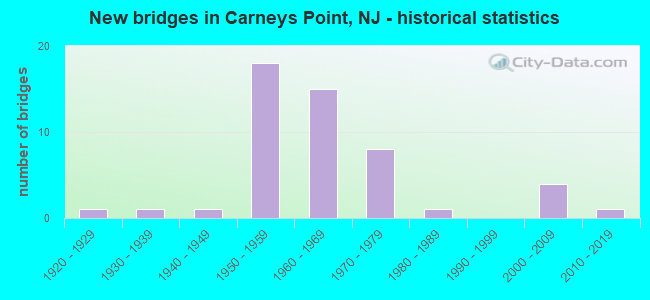
- New bridges - historical statistics
- 11920-1929
- 11930-1939
- 11940-1949
- 181950-1959
- 151960-1969
- 81970-1979
- 11980-1989
- 42000-2009
- 12010-2019

- Reconstructed bridges - Historical Statistics
- 41990-1999
- 22000-2009
- 02010-2019
- 12020-2022


- Bridge Condition - Deck
- 17.2%Very good
- 27.6%Good
- 31.0%Satisfactory
- 17.2%Fair
- 6.9%Poor

- Bridge Condition - Superstructure
- 3.4%Excellent
- 3.4%Very good
- 34.5%Good
- 27.6%Satisfactory
- 27.6%Fair
- 3.4%Poor

- Bridge Condition - Substructure
- 6.9%Very good
- 20.7%Good
- 51.7%Satisfactory
- 17.2%Fair
- 3.4%Poor

- Bridge Condition - Channel
- 6.3%Excellent
- 25.0%Very good
- 25.0%Good
- 43.8%Satisfactory
Find on map >> Show street view
Structure Number: 17002, Location: 0.7 MI. SOUTHEAST OF US40 (Lat: 39.670531, Lng: -75.470250), Route carried "on" structure: County highway 540, Year Built: 1937, Status: Open, Structure Length: 3.08m (10.10ft), Average Daily Traffic: 5,770 (year 2021), Truck Traffic: 3%, Average Future Daily Traffic: 6,920 (year 2041), Features Intersected: SALEM CREEK
Minimum Vertical Clearance: 30+ m (98+ ft), Kilometerpoint: 2.462, Lanes on structure: 2, Owner: County Highway Agency, Approaching Roadway Width: 12.2m (40.0ft), Skew: 1 degrees, Material/Design: Steel, Design/Construction: Stringer/Multi-beam, Number Of Spans In Main Unit: 3, Length of Maximum Span: 9.8m (32.2ft), Curb-To-Curb Width: 12.2m (40.0ft), Out-to-Out Width: 13.4m (44.0ft)
Condition: Deck: Satisfactory, Superstructure: Satisfactory, Substructure: Satisfactory, Channel: Satisfactory, Operating Rating: 53.5 metric tons, Method Used To Determine Operating Rating: Load Factor (LF), Inventory Rating: 31.8 metric tons, Method Used To Determine Inventory Rating: Load Factor (LF), Structural Evaluation: Equal to present minimum criteria, Deck Geometry: Somewhat better than minimum adequacy, Waterway Adequacy: Equal to present minimum criteria, Approach Roadway Alignment: Equal to present desirable criteria, Designated Inspection Frequency: Every 24 months, Underwater Inspection Frequency: Every 48 months, Inspection Date: August 2021, Underwater Inspection Date: November 2021, Deck Structure Type: Concrete Cast-file-Place, Wearing Surface/Protective System: Wearing Surface: Bituminous
Find on map >> Show street view
Structure Number: 170026, Location: 0.5 MI S.W.OF NJ 48 (Lat: 39.692639, Lng: -75.439611), Route carried "on" structure: County highway 628, Year Built: 1986, Status: Open, Structure Length: 1.58m (5.18ft), Average Daily Traffic: 726 (year 2021), Truck Traffic: 3%, Average Future Daily Traffic: 871 (year 2041), Design Load: HS 20+Mod, Features Intersected: GAME CREEK
Minimum Vertical Clearance: 30+ m (98+ ft), Kilometerpoint: 5.182, Lanes on structure: 2, Owner: County Highway Agency, Approaching Roadway Width: 6.7m (22.0ft), Material/Design: Prestressed concrete, Design/Construction: Slab, Number Of Spans In Main Unit: 1, Length of Maximum Span: 14.3m (46.9ft), Curb-To-Curb Width: 10.4m (34.1ft), Out-to-Out Width: 11.3m (37.1ft)
Condition: Deck: Good, Superstructure: Good, Substructure: Good, Channel: Good, Operating Rating: 88.0 metric tons, Method Used To Determine Operating Rating: Load Factor (LF), Inventory Rating: 52.6 metric tons, Method Used To Determine Inventory Rating: Load Factor (LF), Structural Evaluation: Better than present minimum criteria, Deck Geometry: Equal to present minimum criteria, Waterway Adequacy: Better than present minimum criteria, Approach Roadway Alignment: Equal to present desirable criteria, Designated Inspection Frequency: Every 24 months, Inspection Date: August 2021, Deck Structure Type: Concrete Cast-file-Place, Wearing Surface/Protective System: Wearing Surface: Monolithic Concrete
Find on map >> Show street view
Structure Number: 170115, Location: 2.83 MI WEST OF NJ 48 JCT (Lat: 39.681300, Lng: -75.463050), Route carried "on" structure: US 40, Year Built: 1961, Status: Open, Structure Length: 3.60m (11.81ft), Average Daily Traffic: 9,905 (year 2020), Truck Traffic: 4%, Average Future Daily Traffic: 13,985 (year 2040), Design Load: HS 20+Mod, Features Intersected: WEST BRANCH GAME CREEK
Minimum Vertical Clearance: 30+ m (98+ ft), Kilometerpoint: 4.184, Lanes on structure: 2, Base Highway Network: Yes, Owner: State Highway Agency, Approaching Roadway Width: 11.8m (38.7ft), Skew: 3 degrees, Material/Design: Prestressed concrete, Design/Construction: Stringer/Multi-beam, Number Of Spans In Main Unit: 3, Length of Maximum Span: 15.2m (49.9ft), Curb or Sidewalk Widths: Left: 0.6m (2.0ft), Right: 0.5m (1.6ft), Curb-To-Curb Width: 11.8m (38.7ft), Out-to-Out Width: 14.3m (46.9ft)
Condition: Deck: Satisfactory, Superstructure: Fair, Substructure: Satisfactory, Channel: Satisfactory, Inventory Rating: 42.6 metric tons, Method Used To Determine Inventory Rating: Load Factor (LF), Structural Evaluation: Somewhat better than minimum adequacy, Deck Geometry: Better than present minimum criteria, Waterway Adequacy: Equal to present desirable criteria, Approach Roadway Alignment: Equal to present desirable criteria, Designated Inspection Frequency: Every 24 months, Inspection Date: December 2020, Deck Structure Type: Concrete Cast-file-Place, Wearing Surface/Protective System: Wearing Surface: Monolithic Concrete
Find on map >> Show street view
Structure Number: 1701151, Location: 0.9 MI EAST OF NJTPK (Lat: 39.681811, Lng: -75.462861), Route carried "on" structure: US 40, Year Built: 1941, Status: Open, Structure Length: 1.62m (5.31ft), Average Daily Traffic: 6,440 (year 2020), Truck Traffic: 7%, Average Future Daily Traffic: 7,730 (year 2040), Features Intersected: WEST BRANCH GAME CREEK
Minimum Vertical Clearance: 30+ m (98+ ft), Kilometerpoint: 4.200, Lanes on structure: 2, Base Highway Network: Yes, Owner: State Highway Agency, Approaching Roadway Width: 11.6m (38.1ft), Material/Design: Concrete continuous, Design/Construction: Tee Beam, Number Of Spans In Main Unit: 2, Length of Maximum Span: 7.6m (24.9ft), Curb or Sidewalk Widths: Left: 0.8m (2.6ft), Right: 0.2m (0.7ft), Curb-To-Curb Width: 11.7m (38.4ft), Out-to-Out Width: 13.7m (44.9ft)
Condition: Deck: Poor, Superstructure: Poor, Substructure: Satisfactory, Channel: Satisfactory, Operating Rating: 29.0 metric tons, Method Used To Determine Operating Rating: Load Factor (LF), Inventory Rating: 17.2 metric tons, Method Used To Determine Inventory Rating: Load Factor (LF), Structural Evaluation: Meets minimum limits, Deck Geometry: Better than present minimum criteria, Waterway Adequacy: Equal to present minimum criteria, Approach Roadway Alignment: Equal to present desirable criteria, Length Of Structure Improvement: 2.29m (7.51ft), Designated Inspection Frequency: Every 24 months, Underwater Inspection Frequency: Every 24 months, Inspection Date: June 2020, Underwater Inspection Date: March 2020, Bridge Improvement Cost: $1,210,000, Roadway Improvement Cost: $50,000, Total Project Cost: $1,771,000 ( Estimate for 2020), Deck Structure Type: Concrete Cast-file-Place, Wearing Surface/Protective System: Wearing Surface: Bituminous
Find on map >> Show street view
Structure Number: 1704, Location: PILESGROVE-1 MI SO US 40 (Lat: 39.661331, Lng: -75.408811), Route carried "on" structure: County highway 646, Year Built: 2005, Status: Open, Structure Length: 5.33m (17.49ft), Average Daily Traffic: 1,040 (year 2021), Truck Traffic: 3%, Average Future Daily Traffic: 1,270 (year 2041), Design Load: HS 20+Mod, Features Intersected: SALEM CREEK
Minimum Vertical Clearance: 30+ m (98+ ft), Kilometerpoint: 3.347, Lanes on structure: 2, Owner: County Highway Agency, Approaching Roadway Width: 10.4m (34.1ft), Material/Design: Steel continuous, Design/Construction: Stringer/Multi-beam, Number Of Spans In Main Unit: 3, Length of Maximum Span: 21.3m (69.9ft), Curb-To-Curb Width: 10.4m (34.1ft), Out-to-Out Width: 11.4m (37.4ft)
Condition: Deck: Good, Superstructure: Very good, Substructure: Good, Channel: Satisfactory, Inventory Rating: 57.2 metric tons, Method Used To Determine Inventory Rating: Load Factor (LF), Structural Evaluation: Better than present minimum criteria, Deck Geometry: Equal to present minimum criteria, Waterway Adequacy: Better than present minimum criteria, Approach Roadway Alignment: Equal to present desirable criteria, Designated Inspection Frequency: Every 24 months, Underwater Inspection Frequency: Every 48 months, Inspection Date: September 2021, Underwater Inspection Date: December 2021, Deck Structure Type: Concrete Cast-file-Place, Wearing Surface/Protective System: Wearing Surface: Monolithic Concrete, Deck Protection: Galvanized Reinforcing
Find on map >> Show street view
Structure Number: 170615, Location: 0.2 MI E OF CR 551 (Lat: 39.699519, Lng: -75.437261), Route carried "on" structure: State highway 48, Year Built: 2007, Status: Open, Structure Length: 1.07m (3.51ft), Average Daily Traffic: 4,763 (year 2020), Truck Traffic: 3%, Average Future Daily Traffic: 6,581 (year 2040), Design Load: HL 93, Features Intersected: BR OF GAME CREEK
Minimum Vertical Clearance: 30+ m (98+ ft), Kilometerpoint: 3.734, Lanes on structure: 2, Owner: State Highway Agency, Approaching Roadway Width: 12.2m (40.0ft), Material/Design: Prestressed concrete, Design/Construction: Slab, Number Of Spans In Main Unit: 1, Length of Maximum Span: 10.7m (35.1ft), Curb-To-Curb Width: 12.2m (40.0ft), Out-to-Out Width: 13.4m (44.0ft)
Condition: Deck: Very good, Superstructure: Good, Substructure: Very good, Channel: Very good, Operating Rating: 45.7 metric tons, Method Used To Determine Operating Rating: Load and Resistance Factor Rating (LRFR) rating reported by rating factor(RF) method using HL-93 loadings, Inventory Rating: 35.3 metric tons, Method Used To Determine Inventory Rating: Load and Resistance Factor Rating (LRFR) rating reported by rating factor(RF) method using HL-93 loadings, Structural Evaluation: Better than present minimum criteria, Deck Geometry: Equal to present minimum criteria, Waterway Adequacy: Better than present minimum criteria, Approach Roadway Alignment: Equal to present desirable criteria, Designated Inspection Frequency: Every 24 months, Inspection Date: May 2020, Deck Structure Type: Concrete Cast-file-Place, Wearing Surface/Protective System: Wearing Surface: Bituminous
Find on map >> Show street view
Structure Number: 1706151, Location: 0.8 MILE SE OF ROUTE I295 (Lat: 39.699561, Lng: -75.437261), Route carried "on" structure: State highway 48, Year Built: 1924, Year Reconstructed: 2007, Status: Open, Structure Length: 0.91m (2.99ft), Average Daily Traffic: 4,860 (year 2020), Truck Traffic: 3%, Average Future Daily Traffic: 5,832 (year 2040), Design Load: HL 93, Features Intersected: BRANCH OF GAME CREEK
Minimum Vertical Clearance: 30+ m (98+ ft), Kilometerpoint: 3.814, Lanes on structure: 2, Owner: State Highway Agency, Approaching Roadway Width: 12.2m (40.0ft), Material/Design: Prestressed concrete, Design/Construction: Box Beam or Girders - Multiple, Number Of Spans In Main Unit: 1, Length of Maximum Span: 9.1m (29.9ft), Curb-To-Curb Width: 12.2m (40.0ft), Out-to-Out Width: 13.4m (44.0ft)
Condition: Deck: Very good, Superstructure: Good, Substructure: Very good, Channel: Very good, Operating Rating: 49.2 metric tons, Method Used To Determine Operating Rating: Load and Resistance Factor Rating (LRFR) rating reported by rating factor(RF) method using HL-93 loadings, Inventory Rating: 37.9 metric tons, Method Used To Determine Inventory Rating: Load and Resistance Factor Rating (LRFR) rating reported by rating factor(RF) method using HL-93 loadings, Structural Evaluation: Better than present minimum criteria, Deck Geometry: Equal to present minimum criteria, Waterway Adequacy: Equal to present minimum criteria, Approach Roadway Alignment: Equal to present desirable criteria, Designated Inspection Frequency: Every 24 months, Inspection Date: May 2020, Deck Structure Type: Concrete Cast-file-Place, Wearing Surface/Protective System: Wearing Surface: Bituminous, Membrane: Preformed Fabric
Find on map >> Show street view
Structure Number: 1706152, Location: 0.24 MI W OF NJ TURNPIKE (Lat: 39.691300, Lng: -75.428489), Route carried "on" structure: State highway 48, Year Built: 2017, Status: Open, Structure Length: 1.49m (4.89ft), Average Daily Traffic: 5,792 (year 2021), Truck Traffic: 3%, Average Future Daily Traffic: 6,951 (year 2041), Design Load: HL 93, Features Intersected: TWO PENNY RUN
Minimum Vertical Clearance: 30+ m (98+ ft), Kilometerpoint: 4.925, Lanes on structure: 3, Owner: State Highway Agency, Approaching Roadway Width: 14.6m (47.9ft), Skew: 1 degrees, Material/Design: Prestressed concrete, Design/Construction: Box Beam or Girders - Single/Spread, Number Of Spans In Main Unit: 1, Length of Maximum Span: 13.7m (44.9ft), Curb or Sidewalk Widths: Left: 1.9m (6.2ft), Right: 1.9m (6.2ft), Curb-To-Curb Width: 14.6m (47.9ft), Out-to-Out Width: 19.1m (62.7ft)
Condition: Deck: Very good, Superstructure: Excellent, Substructure: Good, Channel: Excellent, Operating Rating: 71.6 metric tons, Method Used To Determine Operating Rating: Load and Resistance Factor Rating (LRFR) rating reported by rating factor(RF) method using HL-93 loadings, Inventory Rating: 36.6 metric tons, Method Used To Determine Inventory Rating: Load and Resistance Factor Rating (LRFR) rating reported by rating factor(RF) method using HL-93 loadings, Structural Evaluation: Better than present minimum criteria, Deck Geometry: Somewhat better than minimum adequacy, Waterway Adequacy: Equal to present desirable criteria, Approach Roadway Alignment: Equal to present desirable criteria, Designated Inspection Frequency: Every 24 months, Inspection Date: May 2021, Deck Structure Type: Concrete Cast-file-Place, Wearing Surface/Protective System: Wearing Surface: Monolithic Concrete, Deck Protection: Epoxy Coated Reinforcing
Find on map >> Show street view
Structure Number: 171115, Location: AT TURNPIKE INTERCHANGE (Lat: 39.678161, Lng: -75.484561), Route carried "on" structure: Interstate 295, Year Built: 1952, Year Reconstructed: 2020, Status: Open, Structure Length: 13.75m (45.11ft), Average Daily Traffic: 39,411 (year 2020), Truck Traffic: 9%, Average Future Daily Traffic: 46,970 (year 2040), Design Load: HS 20, Features Intersected: NJTPK RT US40SALEM CANAL
Minimum Vertical Clearance: 30+ m (98+ ft), Kilometerpoint: 2.527, Lanes on structure: 3, Lanes under structure: 6, Base Highway Network: Yes, Owner: State Highway Agency, Approaching Roadway Width: 15.2m (49.9ft), Skew: 9 degrees, Material/Design: Steel continuous, Design/Construction: Stringer/Multi-beam, Number Of Spans In Main Unit: 7, Length of Maximum Span: 23.2m (76.1ft), Curb-To-Curb Width: 15.2m (49.9ft), Out-to-Out Width: 16.2m (53.1ft)
Condition: Deck: Very good, Superstructure: Good, Substructure: Satisfactory, Channel: Satisfactory, Operating Rating: 79.8 metric tons, Method Used To Determine Operating Rating: Load Factor (LF), Inventory Rating: 47.2 metric tons, Method Used To Determine Inventory Rating: Load Factor (LF), Structural Evaluation: Equal to present minimum criteria, Deck Geometry: Meets minimum limits, Underclear: Meets minimum limits, Waterway Adequacy: Equal to present desirable criteria, Approach Roadway Alignment: Equal to present minimum criteria, Length Of Structure Improvement: 13.90m (45.60ft), Designated Inspection Frequency: Every 24 months, Underwater Inspection Frequency: Every 48 months, Inspection Date: September 2020, Underwater Inspection Date: October 2018, Bridge Improvement Cost: $4,800,000, Roadway Improvement Cost: $480,000, Total Project Cost: $6,000,000 ( Estimate for 2020), Deck Structure Type: Concrete Cast-file-Place, Wearing Surface/Protective System: Deck Protection: Epoxy Coated Reinforcing
Find on map >> Show street view
Structure Number: 1711151, Location: AT 295-NJ TPK JCT (Lat: 39.679519, Lng: -75.486161), Route carried "on" structure: Interstate 295, Year Built: 1959, Status: Open, Structure Length: 6.61m (21.69ft), Average Daily Traffic: 16,527 (year 2021), Truck Traffic: 9%, Average Future Daily Traffic: 19,832 (year 2041), Design Load: HS 20, Features Intersected: SALEM CANAL
Minimum Vertical Clearance: 30+ m (98+ ft), Kilometerpoint: 2.494, Lanes on structure: 2, Base Highway Network: Yes, Owner: State Highway Agency, Approaching Roadway Width: 11.6m (38.1ft), Skew: 3 degrees, Material/Design: Prestressed concrete, Design/Construction: Stringer/Multi-beam, Number Of Spans In Main Unit: 4, Length of Maximum Span: 15.8m (51.8ft), Curb-To-Curb Width: 11.6m (38.1ft), Out-to-Out Width: 13.1m (43.0ft)
Condition: Deck: Satisfactory, Superstructure: Fair, Substructure: Satisfactory, Channel: Satisfactory, Operating Rating: 31.8 metric tons, Method Used To Determine Operating Rating: Load Factor (LF), Inventory Rating: 20.0 metric tons, Method Used To Determine Inventory Rating: Load Factor (LF), Structural Evaluation: Somewhat better than minimum adequacy, Deck Geometry: Equal to present minimum criteria, Waterway Adequacy: Equal to present desirable criteria, Approach Roadway Alignment: Better than present minimum criteria, Designated Inspection Frequency: Every 24 months, Underwater Inspection Frequency: Every 48 months, Inspection Date: May 2021, Underwater Inspection Date: June 2021, Deck Structure Type: Concrete Cast-file-Place, Wearing Surface/Protective System: Wearing Surface: Latex Concrete
Find on map >> Show street view
Structure Number: 1711152, Location: .73 MI N OF I295 NJTP JCT (Lat: 39.683331, Lng: -75.481161), Route carried "on" structure: State highway 140, Year Built: 1959, Status: Open, Structure Length: 2.10m (6.89ft), Average Daily Traffic: 5,030 (year 2021), Truck Traffic: 4%, Average Future Daily Traffic: 6,035 (year 2041), Design Load: HS 20, Features Intersected: I-295 SB
Minimum Vertical Clearance: 30+ m (98+ ft), Kilometerpoint: 0.756, Lanes on structure: 2, Lanes under structure: 3, Owner: State Highway Agency, Approaching Roadway Width: 12.2m (40.0ft), Material/Design: Steel, Design/Construction: Stringer/Multi-beam, Number Of Spans In Main Unit: 1, Length of Maximum Span: 19.8m (65.0ft), Curb or Sidewalk Widths: Left: 1.8m (5.9ft), Right: 1.8m (5.9ft), Curb-To-Curb Width: 12.2m (40.0ft), Out-to-Out Width: 16.5m (54.1ft)
Condition: Deck: Satisfactory, Superstructure: Good, Substructure: Satisfactory, Operating Rating: 77.1 metric tons, Method Used To Determine Operating Rating: Load Factor (LF), Inventory Rating: 46.3 metric tons, Method Used To Determine Inventory Rating: Load Factor (LF), Structural Evaluation: Equal to present minimum criteria, Deck Geometry: Somewhat better than minimum adequacy, Underclear: Meets minimum limits, Approach Roadway Alignment: Equal to present desirable criteria, Designated Inspection Frequency: Every 24 months, Inspection Date: May 2021, Deck Structure Type: Concrete Cast-file-Place, Wearing Surface/Protective System: Wearing Surface: Monolithic Concrete
Find on map >> Show street view
Structure Number: 1711153, Location: 0.24 MILES N OF US 130 (Lat: 39.677650, Lng: -75.489700), Route carried "on" structure: Interstate 295, Year Built: 1971, Year Reconstructed: 1997, Status: Open, Structure Length: 2.68m (8.79ft), Average Daily Traffic: 34,455 (year 2021), Truck Traffic: 9%, Average Future Daily Traffic: 41,345 (year 2041), Design Load: HS 20, Features Intersected: US 40 RAMP
Minimum Vertical Clearance: 30+ m (98+ ft), Kilometerpoint: 1.915, Lanes on structure: 3, Lanes under structure: 1, Base Highway Network: Yes, Owner: State Highway Agency, Approaching Roadway Width: 12.8m (42.0ft), Material/Design: Steel, Design/Construction: Stringer/Multi-beam, Number Of Spans In Main Unit: 1, Length of Maximum Span: 26.2m (86.0ft), Curb or Sidewalk Widths: Left: 0.2m (0.7ft), Right: 0.2m (0.7ft), Curb-To-Curb Width: 12.9m (42.3ft), Out-to-Out Width: 14.3m (46.9ft)
Condition: Deck: Good, Superstructure: Good, Substructure: Fair, Operating Rating: 77.1 metric tons, Method Used To Determine Operating Rating: Load Factor (LF), Inventory Rating: 46.3 metric tons, Method Used To Determine Inventory Rating: Load Factor (LF), Structural Evaluation: Somewhat better than minimum adequacy, Deck Geometry: High priority of replacement, Underclear: Equal to present minimum criteria, Approach Roadway Alignment: Equal to present minimum criteria, Length Of Structure Improvement: 2.68m (8.79ft), Designated Inspection Frequency: Every 24 months, Inspection Date: March 2021, Bridge Improvement Cost: $189,000, Roadway Improvement Cost: $19,000, Total Project Cost: $381,000 ( Estimate for 2021), Deck Structure Type: Concrete Cast-file-Place, Wearing Surface/Protective System: Wearing Surface: Latex Concrete
Find on map >> Show street view
Structure Number: 1711154, Location: 0.5 MI S OF I-295 EXIT 2 (Lat: 39.677000, Lng: -75.486289), Route carried "on" structure: Interstate 295, Year Built: 1971, Year Reconstructed: 1997, Status: Open, Structure Length: 3.51m (11.52ft), Average Daily Traffic: 36,755 (year 2021), Truck Traffic: 9%, Average Future Daily Traffic: 44,105 (year 2041), Design Load: HS 20, Features Intersected: RMP FROM I-295 SB-RT 551
Minimum Vertical Clearance: 30+ m (98+ ft), Kilometerpoint: 2.237, Lanes on structure: 2, Lanes under structure: 2, Base Highway Network: Yes, Owner: State Highway Agency, Approaching Roadway Width: 12.6m (41.3ft), Skew: 4 degrees, Material/Design: Steel, Design/Construction: Stringer/Multi-beam, Number Of Spans In Main Unit: 1, Length of Maximum Span: 33.5m (109.9ft), Curb or Sidewalk Widths: Left: 0.2m (0.7ft), Right: 0.5m (1.6ft), Curb-To-Curb Width: 12.6m (41.3ft), Out-to-Out Width: 14.0m (45.9ft)
Condition: Deck: Good, Superstructure: Satisfactory, Substructure: Fair, Operating Rating: 86.2 metric tons, Method Used To Determine Operating Rating: Load Factor (LF), Inventory Rating: 51.7 metric tons, Method Used To Determine Inventory Rating: Load Factor (LF), Structural Evaluation: Somewhat better than minimum adequacy, Deck Geometry: Better than present minimum criteria, Underclear: High priority of corrective action, Approach Roadway Alignment: Somewhat better than minimum adequacy, Length Of Structure Improvement: 3.51m (11.52ft), Designated Inspection Frequency: Every 24 months, Inspection Date: March 2021, Bridge Improvement Cost: $828,000, Total Project Cost: $952,000 ( Estimate for 2021), Deck Structure Type: Concrete Cast-file-Place, Wearing Surface/Protective System: Wearing Surface: Latex Concrete
Find on map >> Show street view
Structure Number: 1711155, Location: At I-295-NJTPK JCT (Lat: 39.679431, Lng: -75.485150), Route carried "on" structure: Ramp Interstate 295, Year Built: 1971, Status: Open, Structure Length: 9.72m (31.89ft), Average Daily Traffic: 3,585 (year 2021), Truck Traffic: 9%, Average Future Daily Traffic: 4,300 (year 2041), Design Load: HS 20+Mod, Features Intersected: NJTP & SALEM CANAL
Minimum Vertical Clearance: 30+ m (98+ ft), Kilometerpoint: 2.575, Lanes on structure: 2, Lanes under structure: 5, Owner: State Highway Agency, Approaching Roadway Width: 7.9m (25.9ft), Skew: 1 degrees, Material/Design: Steel continuous, Design/Construction: Stringer/Multi-beam, Number Of Spans In Main Unit: 2, Number Of Approach Spans: 2, Length of Maximum Span: 28.7m (94.2ft), Curb or Sidewalk Widths: Left: 0.7m (2.3ft), Right: 0.8m (2.6ft), Curb-To-Curb Width: 7.9m (25.9ft), Out-to-Out Width: 10.2m (33.5ft)
Condition: Deck: Fair, Superstructure: Satisfactory, Substructure: Satisfactory, Channel: Good, Operating Rating: 73.5 metric tons, Method Used To Determine Operating Rating: Load Factor (LF), Inventory Rating: 43.5 metric tons, Method Used To Determine Inventory Rating: Load Factor (LF), Structural Evaluation: Equal to present minimum criteria, Deck Geometry: High priority of replacement, Underclear: Somewhat better than minimum adequacy, Waterway Adequacy: Superior to present desirable criteria, Approach Roadway Alignment: Equal to present minimum criteria, Length Of Structure Improvement: 9.72m (31.89ft), Designated Inspection Frequency: Every 24 months, Critical Feature Inspection Frequency: Every 24 months, Underwater Inspection Frequency: Every 48 months, Inspection Date: August 2021, Critical Feature Inspection Date: August 2021, Underwater Inspection Date: July 2021, Bridge Improvement Cost: $728,000, Roadway Improvement Cost: $75,000, Total Project Cost: $1,160,000 ( Estimate for 2021), Deck Structure Type: Concrete Cast-file-Place, Wearing Surface/Protective System: Wearing Surface: Monolithic Concrete
Find on map >> Show street view
Structure Number: 1711156, Location: 0.3 mi S of Intrch 2 (Lat: 39.680369, Lng: -75.484800), Route carried "on" structure: Ramp Interstate 295, Year Built: 1971, Status: Open, Structure Length: 4.33m (14.21ft), Average Daily Traffic: 3,655 (year 2021), Truck Traffic: 9%, Average Future Daily Traffic: 4,385 (year 2041), Design Load: HS 20+Mod, Features Intersected: I-295 SB, Facility Carried by Structure: RAMP K
Minimum Vertical Clearance: 30+ m (98+ ft), Kilometerpoint: 2.607, Lanes on structure: 2, Lanes under structure: 2, Owner: State Highway Agency, Approaching Roadway Width: 7.9m (25.9ft), Skew: 5 degrees, Material/Design: Steel, Design/Construction: Stringer/Multi-beam, Number Of Spans In Main Unit: 1, Length of Maximum Span: 42.7m (140.1ft), Curb or Sidewalk Widths: Left: 0.8m (2.6ft), Right: 0.8m (2.6ft), Curb-To-Curb Width: 7.9m (25.9ft), Out-to-Out Width: 10.1m (33.1ft)
Condition: Deck: Satisfactory, Superstructure: Satisfactory, Substructure: Poor, Operating Rating: 51.7 metric tons, Method Used To Determine Operating Rating: Load Factor (LF), Inventory Rating: 30.8 metric tons, Method Used To Determine Inventory Rating: Load Factor (LF), Structural Evaluation: Meets minimum limits, Deck Geometry: High priority of replacement, Underclear: High priority of replacement, Approach Roadway Alignment: Equal to present minimum criteria, Length Of Structure Improvement: 5.21m (17.09ft), Designated Inspection Frequency: Every 24 months, Inspection Date: May 2021, Bridge Improvement Cost: $2,558,000, Roadway Improvement Cost: $264,000, Total Project Cost: $3,919,000 ( Estimate for 2021), Deck Structure Type: Concrete Cast-file-Place, Wearing Surface/Protective System: Wearing Surface: Monolithic Concrete
Find on map >> Show street view
Structure Number: 1711157, Location: AT I-295 EXIT 2 (Lat: 39.683169, Lng: -75.480881), Route carried "on" structure: State highway 140, Year Built: 1952, Status: Open, Structure Length: 1.89m (6.20ft), Average Daily Traffic: 5,080 (year 2021), Truck Traffic: 4%, Average Future Daily Traffic: 6,095 (year 2041), Design Load: HS 20, Features Intersected: I-295 NB
Minimum Vertical Clearance: 30+ m (98+ ft), Kilometerpoint: 0.756, Lanes on structure: 2, Lanes under structure: 3, Owner: State Highway Agency, Approaching Roadway Width: 12.2m (40.0ft), Material/Design: Steel, Design/Construction: Stringer/Multi-beam, Number Of Spans In Main Unit: 1, Length of Maximum Span: 15.8m (51.8ft), Curb or Sidewalk Widths: Left: 1.8m (5.9ft), Right: 1.8m (5.9ft), Curb-To-Curb Width: 12.2m (40.0ft), Out-to-Out Width: 16.5m (54.1ft)
Condition: Deck: Fair, Superstructure: Fair, Substructure: Good, Operating Rating: 62.6 metric tons, Method Used To Determine Operating Rating: Load Factor (LF), Inventory Rating: 37.2 metric tons, Method Used To Determine Inventory Rating: Load Factor (LF), Structural Evaluation: Somewhat better than minimum adequacy, Deck Geometry: Somewhat better than minimum adequacy, Underclear: High priority of corrective action, Approach Roadway Alignment: Equal to present desirable criteria, Length Of Structure Improvement: 1.65m (5.41ft), Designated Inspection Frequency: Every 24 months, Inspection Date: May 2021, Roadway Improvement Cost: $132,000, Total Project Cost: $175,000 ( Estimate for 2021), Deck Structure Type: Concrete Cast-file-Place
Find on map >> Show street view
Structure Number: 171215, Location: 1.43 MI SOUTH OF RT 48 (Lat: 39.695219, Lng: -75.466739), Route carried "on" structure: Interstate 295, Year Built: 1965, Status: Open, Structure Length: 1.83m (6.00ft), Average Daily Traffic: 9,500 (year 2021), Truck Traffic: 9%, Average Future Daily Traffic: 11,400 (year 2041), Design Load: HS 20, Features Intersected: HOLLYWOOD AVE (CR 618)
Minimum Vertical Clearance: 30+ m (98+ ft), Kilometerpoint: 4.876, Lanes on structure: 2, Lanes under structure: 2, Base Highway Network: Yes, Owner: State Highway Agency, Approaching Roadway Width: 11.9m (39.0ft), Material/Design: Steel, Design/Construction: Stringer/Multi-beam, Number Of Spans In Main Unit: 1, Length of Maximum Span: 17.1m (56.1ft), Curb-To-Curb Width: 11.9m (39.0ft), Out-to-Out Width: 13.6m (44.6ft)
Condition: Deck: Good, Superstructure: Good, Substructure: Fair, Operating Rating: 79.8 metric tons, Method Used To Determine Operating Rating: Load Factor (LF), Inventory Rating: 47.2 metric tons, Method Used To Determine Inventory Rating: Load Factor (LF), Structural Evaluation: Somewhat better than minimum adequacy, Deck Geometry: Equal to present minimum criteria, Underclear: Equal to present minimum criteria, Approach Roadway Alignment: Equal to present desirable criteria, Designated Inspection Frequency: Every 24 months, Inspection Date: March 2021, Deck Structure Type: Concrete Cast-file-Place, Wearing Surface/Protective System: Wearing Surface: Latex Concrete
Find on map >> Show street view
Structure Number: 1712151, Location: 1.43 MI SO OF RT 48 (Lat: 39.695411, Lng: -75.467000), Route carried "on" structure: Interstate 295, Year Built: 1965, Status: Open, Structure Length: 1.83m (6.00ft), Average Daily Traffic: 9,500 (year 2021), Truck Traffic: 9%, Average Future Daily Traffic: 11,400 (year 2041), Design Load: HS 20, Features Intersected: HOLLYWOOD AVE (CO. 618)
Minimum Vertical Clearance: 30+ m (98+ ft), Kilometerpoint: 4.876, Lanes on structure: 2, Lanes under structure: 2, Base Highway Network: Yes, Owner: State Highway Agency, Approaching Roadway Width: 11.9m (39.0ft), Material/Design: Steel, Design/Construction: Stringer/Multi-beam, Number Of Spans In Main Unit: 1, Length of Maximum Span: 17.1m (56.1ft), Curb or Sidewalk Widths: Left: 0.5m (1.6ft), Right: 0.5m (1.6ft), Curb-To-Curb Width: 11.9m (39.0ft), Out-to-Out Width: 13.6m (44.6ft)
Condition: Deck: Good, Superstructure: Good, Substructure: Fair, Operating Rating: 83.5 metric tons, Method Used To Determine Operating Rating: Load Factor (LF), Inventory Rating: 49.9 metric tons, Method Used To Determine Inventory Rating: Load Factor (LF), Structural Evaluation: Somewhat better than minimum adequacy, Deck Geometry: Equal to present minimum criteria, Underclear: Equal to present minimum criteria, Approach Roadway Alignment: Equal to present desirable criteria, Designated Inspection Frequency: Every 24 months, Inspection Date: March 2021, Deck Structure Type: Concrete Cast-file-Place, Wearing Surface/Protective System: Wearing Surface: Latex Concrete
Find on map >> Show street view
Structure Number: 1712152, Location: 0.5 Mi. S. of Rte. NJ 48 (Lat: 39.704719, Lng: -75.454500), Route carried "on" structure: County highway 629, Year Built: 1965, Status: Open, Structure Length: 7.77m (25.49ft), Average Daily Traffic: 928 (year 2020), Truck Traffic: 1%, Average Future Daily Traffic: 1,114 (year 2040), Design Load: HS 20, Features Intersected: I-295
Minimum Vertical Clearance: 30+ m (98+ ft), Kilometerpoint: 0.338, Lanes on structure: 2, Lanes under structure: 5, Owner: State Highway Agency, Approaching Roadway Width: 9.1m (29.9ft), Material/Design: Steel, Design/Construction: Stringer/Multi-beam, Number Of Spans In Main Unit: 5, Length of Maximum Span: 20.1m (65.9ft), Curb or Sidewalk Widths: Left: 1.8m (5.9ft), Right: 0.5m (1.6ft), Curb-To-Curb Width: 9.1m (29.9ft), Out-to-Out Width: 12.0m (39.4ft)
Condition: Deck: Fair, Superstructure: Satisfactory, Substructure: Satisfactory, Inventory Rating: 56.2 metric tons, Method Used To Determine Inventory Rating: Load Factor (LF), Structural Evaluation: Equal to present minimum criteria, Deck Geometry: Equal to present minimum criteria, Underclear: High priority of corrective action, Approach Roadway Alignment: Better than present minimum criteria, Length Of Structure Improvement: 7.80m (25.59ft), Designated Inspection Frequency: Every 24 months, Inspection Date: July 2020, Bridge Improvement Cost: $1,902,000, Roadway Improvement Cost: $150,000, Total Project Cost: $4,028,000 ( Estimate for 2020), Deck Structure Type: Concrete Cast-file-Place, Wearing Surface/Protective System: Wearing Surface: Monolithic Concrete
Find on map >> Show street view
Structure Number: 1712153, Location: I-295 interchange (Lat: 39.708839, Lng: -75.446700), Route carried "on" structure: State highway 48, Year Built: 1965, Status: Open, Structure Length: 7.83m (25.69ft), Average Daily Traffic: 7,004 (year 2020), Truck Traffic: 4%, Average Future Daily Traffic: 8,546 (year 2040), Design Load: HS 20+Mod, Features Intersected: I-295
Minimum Vertical Clearance: 30.45m (99.90ft), Kilometerpoint: 2.462, Lanes on structure: 3, Lanes under structure: 5, Owner: State Highway Agency, Approaching Roadway Width: 12.2m (40.0ft), Material/Design: Steel, Design/Construction: Stringer/Multi-beam, Number Of Spans In Main Unit: 5, Length of Maximum Span: 20.4m (66.9ft), Curb or Sidewalk Widths: Left: 1.8m (5.9ft), Right: 0.0m, Curb-To-Curb Width: 12.2m (40.0ft), Out-to-Out Width: 15.1m (49.5ft)
Condition: Deck: Poor, Superstructure: Good, Substructure: Satisfactory, Operating Rating: 76.2 metric tons, Method Used To Determine Operating Rating: Load Factor (LF), Inventory Rating: 45.4 metric tons, Method Used To Determine Inventory Rating: Load Factor (LF), Structural Evaluation: Equal to present minimum criteria, Deck Geometry: Meets minimum limits, Underclear: High priority of corrective action, Approach Roadway Alignment: Equal to present desirable criteria, Length Of Structure Improvement: 7.83m (25.69ft), Designated Inspection Frequency: Every 24 months, Inspection Date: August 2020, Bridge Improvement Cost: $5,141,000, Roadway Improvement Cost: $228,000, Total Project Cost: $6,174,000 ( Estimate for 2020), Deck Structure Type: Concrete Cast-file-Place, Wearing Surface/Protective System: Wearing Surface: Monolithic Concrete
Find on map >> Show street view
Structure Number: 1712154, Location: 0.37 MI NORTH OF NJ 48 (Lat: 39.711869, Lng: -75.440539), Route carried "on" structure: Interstate 295, Year Built: 1966, Status: Open, Structure Length: 0.67m (2.20ft), Average Daily Traffic: 20,060 (year 2021), Truck Traffic: 9%, Average Future Daily Traffic: 24,070 (year 2041), Design Load: HS 20, Features Intersected: GAME BRANCH
Minimum Vertical Clearance: 30+ m (98+ ft), Kilometerpoint: 7.773, Lanes on structure: 3, Base Highway Network: Yes, Owner: State Highway Agency, Approaching Roadway Width: 15.2m (49.9ft), Skew: 3 degrees, Material/Design: Concrete, Design/Construction: Culvert, Number Of Spans In Main Unit: 1, Length of Maximum Span: 6.7m (22.0ft), Curb-To-Curb Width: 15.2m (49.9ft), Out-to-Out Width: 26.5m (86.9ft)
Condition: Channel: Satisfactory, Culverts: Satisfactory, Operating Rating: 49.9 metric tons, Method Used To Determine Operating Rating: Load Factor (LF), Inventory Rating: 29.9 metric tons, Method Used To Determine Inventory Rating: Load Factor (LF), Structural Evaluation: Equal to present minimum criteria, Deck Geometry: Meets minimum limits, Waterway Adequacy: Superior to present desirable criteria, Approach Roadway Alignment: Equal to present desirable criteria, Designated Inspection Frequency: Every 24 months, Inspection Date: March 2021
Find on map >> Show street view
Structure Number: 1712155, Location: 3.2 MI NORTH OF TURNPIKE (Lat: 39.712389, Lng: -75.440619), Route carried "on" structure: Interstate 295, Year Built: 1966, Status: Open, Structure Length: 0.67m (2.20ft), Average Daily Traffic: 19,920 (year 2021), Truck Traffic: 9%, Average Future Daily Traffic: 23,905 (year 2041), Design Load: HS 20, Features Intersected: GAME BRANCH
Minimum Vertical Clearance: 30+ m (98+ ft), Kilometerpoint: 7.773, Lanes on structure: 2, Base Highway Network: Yes, Owner: State Highway Agency, Approaching Roadway Width: 12.5m (41.0ft), Skew: 3 degrees, Material/Design: Concrete, Design/Construction: Culvert, Number Of Spans In Main Unit: 1, Length of Maximum Span: 6.7m (22.0ft)
Condition: Channel: Good, Culverts: Satisfactory, Operating Rating: 50.8 metric tons, Method Used To Determine Operating Rating: Load Factor (LF), Inventory Rating: 30.8 metric tons, Method Used To Determine Inventory Rating: Load Factor (LF), Structural Evaluation: Equal to present minimum criteria, Waterway Adequacy: Superior to present desirable criteria, Approach Roadway Alignment: Equal to present desirable criteria, Designated Inspection Frequency: Every 24 months, Inspection Date: March 2021
Find on map >> Show street view
Structure Number: 1712156, Location: 0.89 M NE of 295&RT48 JCT (Lat: 39.716750, Lng: -75.433331), Route carried "on" structure: County highway 641, Year Built: 1965, Status: Open, Structure Length: 6.31m (20.70ft), Average Daily Traffic: 1,645 (year 2020), Truck Traffic: 1%, Average Future Daily Traffic: 1,973 (year 2040), Design Load: HS 20, Features Intersected: I-295, Facility Carried by Structure: PENNSGROVE-AUB RD
Minimum Vertical Clearance: 30+ m (98+ ft), Kilometerpoint: 3.524, Lanes on structure: 2, Lanes under structure: 4, Owner: State Highway Agency, Approaching Roadway Width: 9.1m (29.9ft), Material/Design: Steel, Design/Construction: Stringer/Multi-beam, Number Of Spans In Main Unit: 3, Length of Maximum Span: 20.4m (66.9ft), Curb or Sidewalk Widths: Left: 0.5m (1.6ft), Right: 1.8m (5.9ft), Curb-To-Curb Width: 9.1m (29.9ft), Out-to-Out Width: 12.0m (39.4ft)
Condition: Deck: Satisfactory, Superstructure: Satisfactory, Substructure: Satisfactory, Operating Rating: 70.8 metric tons, Method Used To Determine Operating Rating: Load Factor (LF), Inventory Rating: 42.6 metric tons, Method Used To Determine Inventory Rating: Load Factor (LF), Structural Evaluation: Equal to present minimum criteria, Deck Geometry: Somewhat better than minimum adequacy, Underclear: High priority of corrective action, Approach Roadway Alignment: Better than present minimum criteria, Length Of Structure Improvement: 6.30m (20.67ft), Designated Inspection Frequency: Every 24 months, Inspection Date: July 2020, Bridge Improvement Cost: $1,022,000, Roadway Improvement Cost: $102,000, Total Project Cost: $1,431,000 ( Estimate for 2020), Deck Structure Type: Concrete Cast-file-Place, Wearing Surface/Protective System: Wearing Surface: Latex Concrete
Find on map >> Show street view
Structure Number: 1712157, Location: 2 MI NE OF I-295&NJ48 JCT (Lat: 39.727161, Lng: -75.415711), Route carried "on" structure: County highway 644, Year Built: 1965, Status: Open, Structure Length: 6.40m (21.00ft), Average Daily Traffic: 910 (year 2021), Truck Traffic: 3%, Average Future Daily Traffic: 1,165 (year 2041), Design Load: HS 20, Features Intersected: I-295, Facility Carried by Structure: PERKINTOWN ROAD
Minimum Vertical Clearance: 30+ m (98+ ft), Kilometerpoint: 3.830, Lanes on structure: 2, Lanes under structure: 4, Owner: State Highway Agency, Approaching Roadway Width: 12.2m (40.0ft), Material/Design: Steel, Design/Construction: Stringer/Multi-beam, Number Of Spans In Main Unit: 3, Length of Maximum Span: 20.4m (66.9ft), Curb or Sidewalk Widths: Left: 1.8m (5.9ft), Right: 0.5m (1.6ft), Curb-To-Curb Width: 9.1m (29.9ft), Out-to-Out Width: 12.0m (39.4ft)
Condition: Deck: Fair, Superstructure: Satisfactory, Substructure: Satisfactory, Operating Rating: 89.8 metric tons, Method Used To Determine Operating Rating: Load Factor (LF), Inventory Rating: 53.5 metric tons, Method Used To Determine Inventory Rating: Load Factor (LF), Structural Evaluation: Equal to present minimum criteria, Deck Geometry: Equal to present minimum criteria, Underclear: High priority of corrective action, Approach Roadway Alignment: Equal to present minimum criteria, Length Of Structure Improvement: 6.40m (21.00ft), Designated Inspection Frequency: Every 24 months, Inspection Date: March 2021, Bridge Improvement Cost: $1,152,000, Roadway Improvement Cost: $169,000, Total Project Cost: $1,683,000 ( Estimate for 2021), Deck Structure Type: Concrete Cast-file-Place, Wearing Surface/Protective System: Wearing Surface: Monolithic Concrete
Find on map >> Show street view
Structure Number: M00042, Location: 0.4 MI N OF START OF TPK (Lat: 39.678869, Lng: -75.485539), Route carried "on" structure: Other road NJTPK, Year Built: 1951, Year Reconstructed: 1990, Status: Open, Structure Length: 8.87m (29.10ft), Average Daily Traffic: 51,425 (year 2020), Truck Traffic: 5%, Average Future Daily Traffic: 62,748 (year 2040), Design Load: HS 20, Features Intersected: SALEM CANAL, Facility Carried by Structure: NJ TURNPIKE
Minimum Vertical Clearance: 30+ m (98+ ft), Kilometerpoint: 1.014, Lanes on structure: 6, Base Highway Network: Yes, Toll: On toll road, Owner: State Toll Authority, Approaching Roadway Width: 17.1m (56.1ft), Skew: 35 degrees, Material/Design: Steel continuous, Design/Construction: Stringer/Multi-beam, Number Of Spans In Main Unit: 4, Length of Maximum Span: 22.3m (73.2ft), Curb or Sidewalk Widths: Left: 0.6m (2.0ft), Right: 0.6m (2.0ft), Curb-To-Curb Width: 32.9m (107.9ft), Out-to-Out Width: 37.8m (124.0ft)
Condition: Deck: Fair, Superstructure: Fair, Substructure: Satisfactory, Channel: Very good, Operating Rating: 29.8 metric tons, Method Used To Determine Operating Rating: Load and Resistance Factor Rating (LRFR) rating reported by rating factor(RF) method using HL-93 loadings, Inventory Rating: 23.0 metric tons, Method Used To Determine Inventory Rating: Load and Resistance Factor Rating (LRFR) rating reported by rating factor(RF) method using HL-93 loadings, Structural Evaluation: Somewhat better than minimum adequacy, Deck Geometry: Superior to present desirable criteria, Waterway Adequacy: Equal to present desirable criteria, Approach Roadway Alignment: Equal to present desirable criteria, Designated Inspection Frequency: Every 24 months, Underwater Inspection Frequency: Every 48 months, Inspection Date: April 2020, Underwater Inspection Date: April 2018, Deck Structure Type: Concrete Cast-file-Place, Wearing Surface/Protective System: Wearing Surface: Bituminous, Membrane: Other
Find on map >> Show street view
Structure Number: M00085, Location: 0.8 MI NORTH OF START (Lat: 39.680250, Lng: -75.477478), Route carried "on" structure: State highway 140, Year Built: 1951, Status: Open, Structure Length: 5.67m (18.60ft), Average Daily Traffic: 15,942 (year 2020), Truck Traffic: 4%, Average Future Daily Traffic: 17,286 (year 2040), Design Load: H 20, Features Intersected: NJ TURNPIKE, Facility Carried by Structure: HAWKS BRIDGE ROAD
Minimum Vertical Clearance: 30+ m (98+ ft), Kilometerpoint: 1.255, Lanes on structure: 2, Lanes under structure: 5, Owner: State Toll Authority, Approaching Roadway Width: 13.7m (44.9ft), Material/Design: Steel continuous, Design/Construction: Stringer/Multi-beam, Number Of Spans In Main Unit: 4, Length of Maximum Span: 22.9m (75.1ft), Curb-To-Curb Width: 13.6m (44.6ft), Out-to-Out Width: 14.6m (47.9ft)
Condition: Deck: Good, Superstructure: Satisfactory, Substructure: Satisfactory, Operating Rating: 36.0 metric tons, Method Used To Determine Operating Rating: Load and Resistance Factor Rating (LRFR) rating reported by rating factor(RF) method using HL-93 loadings, Inventory Rating: 27.9 metric tons, Method Used To Determine Inventory Rating: Load and Resistance Factor Rating (LRFR) rating reported by rating factor(RF) method using HL-93 loadings, Structural Evaluation: Equal to present minimum criteria, Deck Geometry: Superior to present desirable criteria, Underclear: High priority of corrective action, Approach Roadway Alignment: Equal to present desirable criteria, Length Of Structure Improvement: 5.67m (18.60ft), Designated Inspection Frequency: Every 24 months, Inspection Date: Febuary 2020, Bridge Improvement Cost: $212,000, Roadway Improvement Cost: $106,000, Total Project Cost: $318,000 ( Estimate for 2016), Deck Structure Type: Concrete Cast-file-Place, Wearing Surface/Protective System: Wearing Surface: Bituminous, Membrane: Preformed Fabric
Find on map >> Show street view
Structure Number: M00166, Location: 0.4 MI NORTH OF EXIT 1 (Lat: 39.682619, Lng: -75.462900), Route carried "on" structure: Other road NJTPK, Year Built: 1951, Year Reconstructed: 1990, Status: Open, Structure Length: 3.23m (10.60ft), Average Daily Traffic: 51,321 (year 2020), Truck Traffic: 5%, Average Future Daily Traffic: 62,622 (year 2040), Design Load: HS 20, Features Intersected: GAME CREEK, Facility Carried by Structure: NJ TURNPIKE
Minimum Vertical Clearance: 30+ m (98+ ft), Kilometerpoint: 3.026, Lanes on structure: 4, Base Highway Network: Yes, Toll: On toll road, Owner: State Toll Authority, Approaching Roadway Width: 29.6m (97.1ft), Skew: 33 degrees, Material/Design: Steel continuous, Design/Construction: Stringer/Multi-beam, Number Of Spans In Main Unit: 3, Length of Maximum Span: 15.2m (49.9ft), Curb or Sidewalk Widths: Left: 0.0m, Right: 0.6m (2.0ft), Curb-To-Curb Width: 27.7m (90.9ft), Out-to-Out Width: 30.5m (100.1ft)
Condition: Deck: Satisfactory, Superstructure: Fair, Substructure: Good, Channel: Very good, Operating Rating: 37.9 metric tons, Method Used To Determine Operating Rating: Load and Resistance Factor Rating (LRFR) rating reported by rating factor(RF) method using HL-93 loadings, Inventory Rating: 29.2 metric tons, Method Used To Determine Inventory Rating: Load and Resistance Factor Rating (LRFR) rating reported by rating factor(RF) method using HL-93 loadings, Structural Evaluation: Somewhat better than minimum adequacy, Deck Geometry: Superior to present desirable criteria, Waterway Adequacy: Equal to present desirable criteria, Approach Roadway Alignment: Equal to present desirable criteria, Designated Inspection Frequency: Every 24 months, Inspection Date: March 2020, Deck Structure Type: Concrete Cast-file-Place, Wearing Surface/Protective System: Wearing Surface: Bituminous, Membrane: Preformed Fabric
Find on map >> Show street view
Structure Number: M00304, Location: 1.8 MI NORTH OF EXIT 1 (Lat: 39.687419, Lng: -75.437258), Route carried "on" structure: County highway 628, Year Built: 1950, Status: Open, Structure Length: 7.44m (24.41ft), Average Daily Traffic: 1,147 (year 2020), Truck Traffic: 3%, Average Future Daily Traffic: 1,376 (year 2040), Design Load: H 20, Features Intersected: NJ TURNPIKE, Facility Carried by Structure: COURSES LANDING RD
Minimum Vertical Clearance: 30+ m (98+ ft), Kilometerpoint: 4.361, Lanes on structure: 2, Lanes under structure: 4, Owner: State Toll Authority, Approaching Roadway Width: 10.7m (35.1ft), Skew: 4 degrees, Material/Design: Steel continuous, Design/Construction: Stringer/Multi-beam, Number Of Spans In Main Unit: 4, Length of Maximum Span: 23.5m (77.1ft), Curb or Sidewalk Widths: Left: 0.6m (2.0ft), Right: 0.6m (2.0ft), Curb-To-Curb Width: 9.1m (29.9ft), Out-to-Out Width: 11.0m (36.1ft)
Condition: Deck: Satisfactory, Superstructure: Fair, Substructure: Satisfactory, Operating Rating: 33.0 metric tons, Method Used To Determine Operating Rating: Load and Resistance Factor Rating (LRFR) rating reported by rating factor(RF) method using HL-93 loadings, Inventory Rating: 25.3 metric tons, Method Used To Determine Inventory Rating: Load and Resistance Factor Rating (LRFR) rating reported by rating factor(RF) method using HL-93 loadings, Structural Evaluation: Somewhat better than minimum adequacy, Deck Geometry: Somewhat better than minimum adequacy, Underclear: Meets minimum limits, Approach Roadway Alignment: Equal to present desirable criteria, Designated Inspection Frequency: Every 24 months, Inspection Date: Febuary 2020, Deck Structure Type: Concrete Cast-file-Place, Wearing Surface/Protective System: Wearing Surface: Monolithic Concrete
Find on map >> Show street view
Structure Number: M00372R, Location: 2.5 MI NORTH OF EXIT 1 (Lat: 39.689331, Lng: -75.424789), Route carried "on" structure: State highway 48, Year Built: 2005, Status: Open, Structure Length: 7.68m (25.20ft), Average Daily Traffic: 4,052 (year 2020), Truck Traffic: 3%, Average Future Daily Traffic: 4,943 (year 2040), Design Load: HL 93, Features Intersected: NJ TURNPIKE
Minimum Vertical Clearance: 30+ m (98+ ft), Kilometerpoint: 5.311, Lanes on structure: 2, Lanes under structure: 4, Owner: State Toll Authority, Approaching Roadway Width: 13.4m (44.0ft), Skew: 4 degrees, Material/Design: Steel continuous, Design/Construction: Stringer/Multi-beam, Number Of Spans In Main Unit: 2, Length of Maximum Span: 37.8m (124.0ft), Curb or Sidewalk Widths: Left: 1.8m (5.9ft), Right: 1.8m (5.9ft), Curb-To-Curb Width: 13.4m (44.0ft), Out-to-Out Width: 17.7m (58.1ft)
Condition: Deck: Good, Superstructure: Good, Substructure: Good, Operating Rating: 44.7 metric tons, Method Used To Determine Operating Rating: Load and Resistance Factor Rating (LRFR) rating reported by rating factor(RF) method using HL-93 loadings, Inventory Rating: 34.3 metric tons, Method Used To Determine Inventory Rating: Load and Resistance Factor Rating (LRFR) rating reported by rating factor(RF) method using HL-93 loadings, Structural Evaluation: Better than present minimum criteria, Deck Geometry: Better than present minimum criteria, Underclear: High priority of corrective action, Approach Roadway Alignment: Equal to present desirable criteria, Length Of Structure Improvement: 7.68m (25.20ft), Designated Inspection Frequency: Every 24 months, Inspection Date: March 2020, Bridge Improvement Cost: $1,313,000, Roadway Improvement Cost: $260,000, Total Project Cost: $1,725,000 ( Estimate for 2016), Deck Structure Type: Concrete Cast-file-Place, Wearing Surface/Protective System: Wearing Surface: Monolithic Concrete, Deck Protection: Epoxy Coated Reinforcing
Find on map >> Show street view
Structure Number: M00393, Location: 0.21 MI N OF NJ 48 (Lat: 39.690042, Lng: -75.421014), Route carried "on" structure: Other road 700, Year Built: 1951, Status: Open, Structure Length: 0.67m (2.20ft), Average Daily Traffic: 51,322 (year 2020), Truck Traffic: 7%, Average Future Daily Traffic: 62,622 (year 2040), Design Load: HS 20, Features Intersected: TWO PENNY RUN, Facility Carried by Structure: TURNPIKE MAINLINE
Minimum Vertical Clearance: 0.00m, Kilometerpoint: 6.502, Lanes on structure: 4, Base Highway Network: Yes, Toll: On toll road, Owner: State Toll Authority, Approaching Roadway Width: 22.9m (75.1ft), Skew: 34 degrees, Material/Design: Concrete, Design/Construction: Culvert, Number Of Spans In Main Unit: 1, Length of Maximum Span: 6.7m (22.0ft)
Condition: Channel: Good, Culverts: Satisfactory, Operating Rating: 83.9 metric tons, Method Used To Determine Operating Rating: Load and Resistance Factor Rating (LRFR) rating reported by rating factor(RF) method using HL-93 loadings, Inventory Rating: 64.8 metric tons, Method Used To Determine Inventory Rating: Load and Resistance Factor Rating (LRFR) rating reported by rating factor(RF) method using HL-93 loadings, Structural Evaluation: Equal to present minimum criteria, Waterway Adequacy: Equal to present desirable criteria, Approach Roadway Alignment: Equal to present desirable criteria, Designated Inspection Frequency: Every 24 months, Inspection Date: March 2020
Find on map >> Show street view
Structure Number: M00489, Location: 3.6 MI NORTH OF EXIT 1 (Lat: 39.694550, Lng: -75.404008), Route carried "on" structure: County highway 641, Year Built: 1950, Status: Open, Structure Length: 5.18m (16.99ft), Average Daily Traffic: 1,645 (year 2020), Truck Traffic: 3%, Average Future Daily Traffic: 2,007 (year 2040), Design Load: H 20, Features Intersected: NJ TURNPIKE, Facility Carried by Structure: PENNSGROVE-AUBURN
Minimum Vertical Clearance: 30+ m (98+ ft), Kilometerpoint: 7.049, Lanes on structure: 2, Lanes under structure: 4, Owner: State Toll Authority, Approaching Roadway Width: 10.7m (35.1ft), Skew: 1 degrees, Material/Design: Steel continuous, Design/Construction: Stringer/Multi-beam, Number Of Spans In Main Unit: 4, Length of Maximum Span: 15.8m (51.8ft), Curb or Sidewalk Widths: Left: 0.6m (2.0ft), Right: 0.6m (2.0ft), Curb-To-Curb Width: 9.1m (29.9ft), Out-to-Out Width: 11.0m (36.1ft)
Condition: Deck: Satisfactory, Superstructure: Fair, Substructure: Satisfactory, Operating Rating: 33.7 metric tons, Method Used To Determine Operating Rating: Load and Resistance Factor Rating (LRFR) rating reported by rating factor(RF) method using HL-93 loadings, Inventory Rating: 25.9 metric tons, Method Used To Determine Inventory Rating: Load and Resistance Factor Rating (LRFR) rating reported by rating factor(RF) method using HL-93 loadings, Structural Evaluation: Somewhat better than minimum adequacy, Deck Geometry: Somewhat better than minimum adequacy, Underclear: Somewhat better than minimum adequacy, Approach Roadway Alignment: Equal to present desirable criteria, Designated Inspection Frequency: Every 24 months, Inspection Date: March 2020, Deck Structure Type: Concrete Cast-file-Place, Wearing Surface/Protective System: Wearing Surface: Monolithic Concrete
Find on map >> Show street view
Structure Number: M00573, Location: 4.5 MI NORTH OF EXIT 1 (Lat: 39.698850, Lng: -75.389278), Route carried "on" structure: City street , Year Built: 1950, Year Reconstructed: 2011, Status: Open, Structure Length: 5.76m (18.90ft), Average Daily Traffic: 655 (year 2020), Truck Traffic: 3%, Average Future Daily Traffic: 800 (year 2040), Design Load: H 20, Features Intersected: NJ TURNPIKE, Facility Carried by Structure: STUMPY ROAD
Minimum Vertical Clearance: 30+ m (98+ ft), Kilometerpoint: 0.000, Lanes on structure: 2, Lanes under structure: 4, Owner: State Toll Authority, Approaching Roadway Width: 10.7m (35.1ft), Skew: 3 degrees, Material/Design: Steel continuous, Design/Construction: Stringer/Multi-beam, Number Of Spans In Main Unit: 4, Length of Maximum Span: 17.7m (58.1ft), Curb-To-Curb Width: 9.9m (32.5ft), Out-to-Out Width: 11.0m (36.1ft)
Condition: Deck: Very good, Superstructure: Fair, Substructure: Fair, Operating Rating: 31.1 metric tons, Method Used To Determine Operating Rating: Load and Resistance Factor Rating (LRFR) rating reported by rating factor(RF) method using HL-93 loadings, Inventory Rating: 24.0 metric tons, Method Used To Determine Inventory Rating: Load and Resistance Factor Rating (LRFR) rating reported by rating factor(RF) method using HL-93 loadings, Structural Evaluation: Somewhat better than minimum adequacy, Deck Geometry: Equal to present minimum criteria, Underclear: Meets minimum limits, Approach Roadway Alignment: Equal to present minimum criteria, Designated Inspection Frequency: Every 24 months, Inspection Date: March 2020, Deck Structure Type: Concrete Cast-file-Place, Wearing Surface/Protective System: Wearing Surface: Monolithic Concrete, Deck Protection: Epoxy Coated Reinforcing
Find on map >> Show street view
Structure Number: 171115, Location: AT TURNPIKE INTERCHANGE (Lat: 39.678161, Lng: -75.484561), Route carried "under" structure: Other road NJTPK, Year Built: 1952, Structure Length: 0. m, Average Daily Traffic: 54,590 (year 2020), Truck Traffic: 9%, Features Intersected: NJTPK RT US40SALEM CANAL, Facility Carried by Structure: I-295 NB
Minimum Vertical Clearance: 4.72m (15.49ft), Kilometerpoint: 1.255, Lanes on structure: 3, Lanes under structure: 6, Material/Design: Steel continuous, Design/Construction: Stringer/Multi-beam, Length of Maximum Span: 23.2m (76.1ft)
Find on map >> Show street view
Structure Number: 1711152, Location: .73 MI N OF I295 NJTP JCT (Lat: 39.683331, Lng: -75.481161), Route carried "under" structure: Interstate 295, Year Built: 1959, Structure Length: 0. m, Average Daily Traffic: 16,240 (year 2021), Truck Traffic: 9%, Features Intersected: I-295 SB, Facility Carried by Structure: NJ 140
Minimum Vertical Clearance: 4.62m (15.16ft), Kilometerpoint: 3.090, Lanes on structure: 2, Lanes under structure: 3, Material/Design: Steel, Design/Construction: Stringer/Multi-beam, Length of Maximum Span: 19.8m (65.0ft)
Find on map >> Show street view
Structure Number: 1711153, Location: 0.24 MILES N OF US 130 (Lat: 39.677650, Lng: -75.489700), Route carried "under" structure: Ramp US 40, Year Built: 1971, Structure Length: 0. m, Average Daily Traffic: 3,680 (year 2021), Truck Traffic: 4%, Features Intersected: US 40 RAMP, Facility Carried by Structure: I-295 NB
Minimum Vertical Clearance: 4.67m (15.32ft), Kilometerpoint: 0.000, Lanes on structure: 3, Lanes under structure: 1, Material/Design: Steel, Design/Construction: Stringer/Multi-beam, Length of Maximum Span: 26.2m (86.0ft)
Find on map >> Show street view
Structure Number: 1711154, Location: 0.5 MI S OF I-295 EXIT 2 (Lat: 39.677000, Lng: -75.486289), Route carried "under" structure: Ramp Interstate 295, Year Built: 1971, Structure Length: 0. m, Average Daily Traffic: 3,865 (year 2021), Truck Traffic: 9%, Features Intersected: RMP FROM I-295 SB-RT 551
Minimum Vertical Clearance: 4.55m (14.93ft), Kilometerpoint: 7.628, Lanes on structure: 2, Lanes under structure: 1, Material/Design: Steel, Design/Construction: Stringer/Multi-beam, Length of Maximum Span: 33.5m (109.9ft)
Find on map >> Show street view
Structure Number: 1711155, Location: At I-295-NJTPK JCT (Lat: 39.679431, Lng: -75.485150), Route carried "under" structure: Other road NJTPK, Year Built: 1971, Structure Length: 0. m, Average Daily Traffic: 52,340 (year 2021), Truck Traffic: 5%, Features Intersected: NJTP & SALEM CANAL, Facility Carried by Structure: I-295 CONNECTOR K
Minimum Vertical Clearance: 5.74m (18.83ft), Kilometerpoint: 1.014, Lanes on structure: 2, Lanes under structure: 5, Toll: On toll road, Material/Design: Steel continuous, Design/Construction: Stringer/Multi-beam, Length of Maximum Span: 28.7m (94.2ft)
Find on map >> Show street view
Structure Number: 1711156, Location: 0.3 mi S of Intrch 2 (Lat: 39.680369, Lng: -75.484800), Route carried "under" structure: Interstate 295, Year Built: 1971, Structure Length: 0. m, Average Daily Traffic: 16,240 (year 2021), Truck Traffic: 9%, Features Intersected: I-295 SB, Facility Carried by Structure: RAMP K
Minimum Vertical Clearance: 4.55m (14.93ft), Kilometerpoint: 2.607, Lanes on structure: 2, Lanes under structure: 2, Material/Design: Steel, Design/Construction: Stringer/Multi-beam, Length of Maximum Span: 42.7m (140.1ft)
Find on map >> Show street view
Structure Number: 1711157, Location: AT I-295 EXIT 2 (Lat: 39.683169, Lng: -75.480881), Route carried "under" structure: Interstate 295, Year Built: 1952, Structure Length: 0. m, Average Daily Traffic: 18,215 (year 2021), Truck Traffic: 9%, Features Intersected: I-295 NB, Facility Carried by Structure: NJ 140
Minimum Vertical Clearance: 4.60m (15.09ft), Kilometerpoint: 3.090, Lanes on structure: 2, Lanes under structure: 3, Material/Design: Steel, Design/Construction: Stringer/Multi-beam, Length of Maximum Span: 15.8m (51.8ft)
Find on map >> Show street view
Structure Number: 171215, Location: 1.43 MI SOUTH OF RT 48 (Lat: 39.695219, Lng: -75.466739), Route carried "under" structure: County highway 618, Year Built: 1965, Structure Length: 0. m, Average Daily Traffic: 3,200 (year 2021), Truck Traffic: 4%, Features Intersected: HOLLYWOOD AVE (CR 618), Facility Carried by Structure: I-295 NB
Minimum Vertical Clearance: 4.72m (15.49ft), Kilometerpoint: 0.113, Lanes on structure: 2, Lanes under structure: 2, Material/Design: Steel, Design/Construction: Stringer/Multi-beam, Length of Maximum Span: 17.1m (56.1ft)
Find on map >> Show street view
Structure Number: 1712151, Location: 1.43 MI SO OF RT 48 (Lat: 39.695411, Lng: -75.467000), Route carried "under" structure: County highway 618, Year Built: 1965, Structure Length: 0. m, Average Daily Traffic: 3,200 (year 2021), Truck Traffic: 3%, Features Intersected: HOLLYWOOD AVE (CO. 618), Facility Carried by Structure: I-295 SB
Minimum Vertical Clearance: 4.44m (14.57ft), Kilometerpoint: 0.113, Lanes on structure: 2, Lanes under structure: 2, Material/Design: Steel, Design/Construction: Stringer/Multi-beam, Length of Maximum Span: 17.1m (56.1ft)
Find on map >> Show street view
Structure Number: 1712152, Location: 0.5 Mi. S. of Rte. NJ 48 (Lat: 39.704719, Lng: -75.454500), Route carried "under" structure: Interstate 295, Year Built: 1965, Structure Length: 0. m, Average Daily Traffic: 29,343 (year 2020), Truck Traffic: 9%, Features Intersected: I-295, Facility Carried by Structure: GEORGETWN RD CR629
Minimum Vertical Clearance: 4.50m (14.76ft), Kilometerpoint: 6.357, Lanes on structure: 2, Lanes under structure: 5, Material/Design: Steel, Design/Construction: Stringer/Multi-beam, Length of Maximum Span: 20.1m (65.9ft)
Find on map >> Show street view
Structure Number: 1712153, Location: I-295 interchange (Lat: 39.708839, Lng: -75.446700), Route carried "under" structure: Interstate 295, Year Built: 1965, Structure Length: 0. m, Average Daily Traffic: 60,143 (year 2020), Truck Traffic: 9%, Features Intersected: I-295, Facility Carried by Structure: RT 48
Minimum Vertical Clearance: 4.50m (14.76ft), Kilometerpoint: 7.178, Lanes on structure: 3, Lanes under structure: 5, Material/Design: Steel, Design/Construction: Stringer/Multi-beam, Length of Maximum Span: 20.4m (66.9ft)
Find on map >> Show street view
Structure Number: 1712156, Location: 0.89 M NE of 295&RT48 JCT (Lat: 39.716750, Lng: -75.433331), Route carried "under" structure: Interstate 295, Year Built: 1965, Structure Length: 0. m, Average Daily Traffic: 30,400 (year 2020), Truck Traffic: 9%, Features Intersected: I-295, Facility Carried by Structure: PENNSGROVE-AUB RD
Minimum Vertical Clearance: 4.54m (14.90ft), Kilometerpoint: 8.610, Lanes on structure: 2, Lanes under structure: 4, Material/Design: Steel, Design/Construction: Stringer/Multi-beam, Length of Maximum Span: 20.4m (66.9ft)
Find on map >> Show street view
Structure Number: 1712157, Location: 2 MI NE OF I-295&NJ48 JCT (Lat: 39.727161, Lng: -75.415711), Route carried "under" structure: Interstate 295, Year Built: 1965, Structure Length: 0. m, Average Daily Traffic: 39,980 (year 2021), Truck Traffic: 14%, Features Intersected: I-295, Facility Carried by Structure: PERKINTOWN ROAD
Minimum Vertical Clearance: 4.57m (14.99ft), Kilometerpoint: 10.525, Lanes on structure: 2, Lanes under structure: 4, Material/Design: Steel, Design/Construction: Stringer/Multi-beam, Length of Maximum Span: 20.4m (66.9ft)
Find on map >> Show street view
Structure Number: M00085, Location: 0.8 MI NORTH OF START (Lat: 39.680250, Lng: -75.477478), Route carried "under" structure: Other road NJTPK, Year Built: 1951, Structure Length: 0. m, Average Daily Traffic: 51,425 (year 2020), Truck Traffic: 14%, Features Intersected: NJ TURNPIKE, Facility Carried by Structure: HAWKS BRIDGE ROAD
Minimum Vertical Clearance: 4.57m (14.99ft), Kilometerpoint: 1.802, Lanes on structure: 2, Lanes under structure: 5, Toll: On toll road, Material/Design: Steel continuous, Design/Construction: Stringer/Multi-beam, Length of Maximum Span: 22.9m (75.1ft)
Find on map >> Show street view
Structure Number: M00304, Location: 1.8 MI NORTH OF EXIT 1 (Lat: 39.687419, Lng: -75.437258), Route carried "under" structure: Other road NJTPK, Year Built: 1950, Structure Length: 0. m, Average Daily Traffic: 51,321 (year 2020), Truck Traffic: 12%, Features Intersected: NJ TURNPIKE, Facility Carried by Structure: COURSES LANDING RD
Minimum Vertical Clearance: 4.65m (15.26ft), Kilometerpoint: 5.182, Lanes on structure: 2, Lanes under structure: 4, Toll: On toll road, Material/Design: Steel continuous, Design/Construction: Stringer/Multi-beam, Length of Maximum Span: 23.5m (77.1ft)
Find on map >> Show street view
Structure Number: M00372R, Location: 2.5 MI NORTH OF EXIT 1 (Lat: 39.689331, Lng: -75.424789), Route carried "under" structure: Other road NJTPK, Year Built: 2005, Structure Length: 0. m, Average Daily Traffic: 51,322 (year 2020), Truck Traffic: 7%, Features Intersected: NJ TURNPIKE, Facility Carried by Structure: NJ 48
Minimum Vertical Clearance: 4.65m (15.26ft), Kilometerpoint: 5.987, Lanes on structure: 2, Lanes under structure: 4, Toll: On toll road, Material/Design: Steel continuous, Design/Construction: Stringer/Multi-beam, Length of Maximum Span: 37.8m (124.0ft)