Bridge Statistics for Blytheville, Arkansas (AR)
Condition, Traffic, Stress, Structural Evaluation, Project Costs
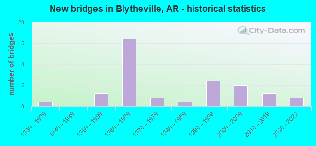
- New bridges - historical statistics
- 11930-1939
- 31950-1959
- 161960-1969
- 21970-1979
- 11980-1989
- 61990-1999
- 52000-2009
- 32010-2019
- 22020-2022

- Reconstructed bridges - Historical Statistics
- 11970-1979
- 71980-1989


- Bridge Condition - Deck
- 3.4%Very good
- 48.3%Good
- 48.3%Satisfactory

- Bridge Condition - Superstructure
- 6.9%Very good
- 55.2%Good
- 34.5%Satisfactory
- 3.4%Fair

- Bridge Condition - Substructure
- 10.3%Very good
- 69.0%Good
- 10.3%Satisfactory
- 6.9%Fair
- 3.4%Poor

- Bridge Condition - Channel
- 7.4%Very good
- 63.0%Good
- 22.2%Satisfactory
- 7.4%Fair

- Bridge Condition - Culverts
- 10.0%Excellent
- 20.0%Very good
- 60.0%Good
- 10.0%Satisfactory
Find on map >> Show street view
Structure Number: 1256, Location: 1.32 MI S OF PEMISCOT CO (Lat: 35.982036, Lng: -89.901056), Route carried "on" structure: US 61, Year Built: 1954, Status: Open, Structure Length: 4.57m (14.99ft), Average Daily Traffic: 1,813 (year 2018), Truck Traffic: 1%, Average Future Daily Traffic: 2,562 (year 2028), Design Load: HS 20, Features Intersected: PEMISCOT BAYOU
Minimum Vertical Clearance: 30+ m (98+ ft), Kilometerpoint: 33.587, Lanes on structure: 2, Owner: State Highway Agency, Approaching Roadway Width: 10.4m (34.1ft), Material/Design: Concrete, Design/Construction: Slab, Number Of Spans In Main Unit: 6, Length of Maximum Span: 7.6m (24.9ft), Curb or Sidewalk Widths: Left: 0.5m (1.6ft), Right: 0.5m (1.6ft), Curb-To-Curb Width: 8.5m (27.9ft), Out-to-Out Width: 9.6m (31.5ft)
Condition: Deck: Good, Superstructure: Good, Substructure: Fair, Channel: Good, Operating Rating: 39.0 metric tons, Method Used To Determine Operating Rating: Load Factor (LF), Inventory Rating: 23.6 metric tons, Method Used To Determine Inventory Rating: Load Factor (LF), Structural Evaluation: Somewhat better than minimum adequacy, Deck Geometry: Somewhat better than minimum adequacy, Waterway Adequacy: Equal to present desirable criteria, Approach Roadway Alignment: Equal to present desirable criteria, Designated Inspection Frequency: Every 24 months, Critical Feature Inspection Frequency: Every 24 months, Inspection Date: May 2021, Deck Structure Type: Concrete Cast-file-Place, Wearing Surface/Protective System: Wearing Surface: Bituminous
Find on map >> Show street view
Structure Number: 1257, Location: 3.18 MI SW of Pemiscot Co (Lat: 35.958519, Lng: -89.910181), Route carried "on" structure: US 61, Year Built: 1951, Status: Posted for load, Structure Length: 2.74m (8.99ft), Average Daily Traffic: 2,600 (year 2018), Truck Traffic: 1%, Average Future Daily Traffic: 3,295 (year 2028), Design Load: H 20, Features Intersected: DITCH NO 30
Minimum Vertical Clearance: 30+ m (98+ ft), Kilometerpoint: 30.594, Lanes on structure: 2, Owner: State Highway Agency, Approaching Roadway Width: 11.0m (36.1ft), Material/Design: Concrete, Design/Construction: Slab, Number Of Spans In Main Unit: 5, Length of Maximum Span: 5.5m (18.0ft), Curb or Sidewalk Widths: Left: 0.5m (1.6ft), Right: 0.5m (1.6ft), Curb-To-Curb Width: 8.5m (27.9ft), Out-to-Out Width: 9.6m (31.5ft)
Condition: Deck: Satisfactory, Superstructure: Satisfactory, Substructure: Poor, Channel: Fair, Operating Rating: 13.6 metric tons, Method Used To Determine Operating Rating: Load Factor (LF), Inventory Rating: 4.5 metric tons, Method Used To Determine Inventory Rating: Load Factor (LF), Structural Evaluation: High priority of replacement, Deck Geometry: Meets minimum limits, Waterway Adequacy: Equal to present desirable criteria, Approach Roadway Alignment: Equal to present desirable criteria, Bridge Posting: Required (Relationship of Operating Rating to Maximum Legal Load: > 39.9% below), Length Of Structure Improvement: 3.54m (11.61ft), Designated Inspection Frequency: Every 24 months, Critical Feature Inspection Frequency: Every 24 months, Inspection Date: May 2021, Roadway Improvement Cost: $125,000, Total Project Cost: $352,000, Deck Structure Type: Concrete Cast-file-Place, Wearing Surface/Protective System: Wearing Surface: Bituminous
Find on map >> Show street view
Structure Number: 1962, Location: 1.78 MI S OF PEMISCOT CO (Lat: 35.977400, Lng: -89.905989), Route carried "on" structure: US 61, Year Built: 1938, Status: Open, Structure Length: 11.48m (37.66ft), Average Daily Traffic: 1,579 (year 2018), Truck Traffic: 1%, Average Future Daily Traffic: 1,952 (year 2028), Design Load: H 15, Features Intersected: SL SF RR
Minimum Vertical Clearance: 30+ m (98+ ft), Kilometerpoint: 32.847, Lanes on structure: 2, Owner: State Highway Agency, Approaching Roadway Width: 10.4m (34.1ft), Material/Design: Steel, Design/Construction: Stringer/Multi-beam, Number Of Spans In Main Unit: 1, Number Of Approach Spans: 12, Length of Maximum Span: 13.4m (44.0ft), Curb-To-Curb Width: 7.3m (24.0ft), Out-to-Out Width: 8.2m (26.9ft)
Condition: Deck: Satisfactory, Superstructure: Fair, Substructure: Satisfactory, Operating Rating: 32.7 metric tons, Method Used To Determine Operating Rating: Load Factor (LF), Inventory Rating: 20.0 metric tons, Method Used To Determine Inventory Rating: Load Factor (LF), Structural Evaluation: Somewhat better than minimum adequacy, Deck Geometry: Meets minimum limits, Underclear: Meets minimum limits, Approach Roadway Alignment: Equal to present minimum criteria, Designated Inspection Frequency: Every 24 months, Critical Feature Inspection Frequency: Every 24 months, Inspection Date: December 2020, Deck Structure Type: Concrete Cast-file-Place, Wearing Surface/Protective System: Wearing Surface: Bituminous
Find on map >> Show street view
Structure Number: 2729, Location: .80 MI N OF ARMOREL ARK (Lat: 35.925358, Lng: -89.785589), Route carried "on" structure: Spur State highway 137, Year Built: 1950, Status: Open, Structure Length: 2.80m (9.19ft), Average Daily Traffic: 820 (year 2018), Truck Traffic: 1%, Average Future Daily Traffic: 1,037 (year 2028), Design Load: H 15, Features Intersected: DITCH 38
Minimum Vertical Clearance: 30+ m (98+ ft), Kilometerpoint: 1.931, Lanes on structure: 2, Owner: County Highway Agency, Approaching Roadway Width: 8.5m (27.9ft), Material/Design: Steel, Design/Construction: Stringer/Multi-beam, Number Of Spans In Main Unit: 3, Length of Maximum Span: 9.1m (29.9ft), Curb or Sidewalk Widths: Left: 0.3m (1.0ft), Right: 0.3m (1.0ft), Curb-To-Curb Width: 7.3m (24.0ft), Out-to-Out Width: 8.1m (26.6ft)
Condition: Deck: Satisfactory, Superstructure: Satisfactory, Substructure: Satisfactory, Channel: Good, Operating Rating: 43.5 metric tons, Method Used To Determine Operating Rating: Load Factor (LF), Inventory Rating: 26.3 metric tons, Method Used To Determine Inventory Rating: Load Factor (LF), Structural Evaluation: Equal to present minimum criteria, Deck Geometry: Meets minimum limits, Waterway Adequacy: Equal to present desirable criteria, Approach Roadway Alignment: Better than present minimum criteria, Designated Inspection Frequency: Every 24 months, Critical Feature Inspection Frequency: Every 24 months, Inspection Date: September 2020, Deck Structure Type: Concrete Cast-file-Place, Wearing Surface/Protective System: Wearing Surface: Bituminous
Find on map >> Show street view
Structure Number: 3164, Location: 2.3 MI N SH 148 JCT (Lat: 35.904361, Lng: -89.891869), Route carried "on" structure: State highway 239, Year Built: 1960, Status: Open, Structure Length: 8.78m (28.81ft), Average Daily Traffic: 1,100 (year 2018), Truck Traffic: 1%, Average Future Daily Traffic: 1,708 (year 2028), Design Load: H 20, Features Intersected: I 55-SEC 12
Minimum Vertical Clearance: 30+ m (98+ ft), Kilometerpoint: 4.426, Lanes on structure: 2, Lanes under structure: 4, Owner: State Highway Agency, Approaching Roadway Width: 9.1m (29.9ft), Skew: 4 degrees, Material/Design: Steel, Design/Construction: Stringer/Multi-beam, Number Of Spans In Main Unit: 4, Length of Maximum Span: 25.9m (85.0ft), Curb or Sidewalk Widths: Left: 0.5m (1.6ft), Right: 0.5m (1.6ft), Curb-To-Curb Width: 7.9m (25.9ft), Out-to-Out Width: 9.4m (30.8ft)
Condition: Deck: Satisfactory, Superstructure: Good, Substructure: Good, Operating Rating: 43.5 metric tons, Method Used To Determine Operating Rating: Load Factor (LF), Inventory Rating: 26.3 metric tons, Method Used To Determine Inventory Rating: Load Factor (LF), Structural Evaluation: Equal to present minimum criteria, Deck Geometry: Meets minimum limits, Underclear: Somewhat better than minimum adequacy, Approach Roadway Alignment: Equal to present desirable criteria, Designated Inspection Frequency: Every 24 months, Critical Feature Inspection Frequency: Every 24 months, Inspection Date: October 2020, Deck Structure Type: Concrete Cast-file-Place, Wearing Surface/Protective System: Wearing Surface: Monolithic Concrete
Find on map >> Show street view
Structure Number: 3165, Location: 0.81 MI E SH 239 JCT (Lat: 35.914336, Lng: -89.878100), Route carried "on" structure: State highway 312, Year Built: 1960, Status: Open, Structure Length: 10.97m (35.99ft), Average Daily Traffic: 380 (year 2018), Truck Traffic: 1%, Average Future Daily Traffic: 769 (year 2028), Design Load: H 20, Features Intersected: I 55-SEC 12 Log66.28
Minimum Vertical Clearance: 30+ m (98+ ft), Kilometerpoint: 1.304, Lanes on structure: 2, Lanes under structure: 4, Owner: State Highway Agency, Approaching Roadway Width: 9.1m (29.9ft), Skew: 5 degrees, Material/Design: Steel, Design/Construction: Stringer/Multi-beam, Number Of Spans In Main Unit: 4, Length of Maximum Span: 27.4m (89.9ft), Curb or Sidewalk Widths: Left: 0.5m (1.6ft), Right: 0.5m (1.6ft), Curb-To-Curb Width: 7.9m (25.9ft), Out-to-Out Width: 9.4m (30.8ft)
Condition: Deck: Satisfactory, Superstructure: Satisfactory, Substructure: Good, Operating Rating: 54.4 metric tons, Method Used To Determine Operating Rating: Load Factor (LF), Inventory Rating: 32.7 metric tons, Method Used To Determine Inventory Rating: Load Factor (LF), Structural Evaluation: Equal to present minimum criteria, Deck Geometry: Somewhat better than minimum adequacy, Underclear: Somewhat better than minimum adequacy, Approach Roadway Alignment: Equal to present desirable criteria, Designated Inspection Frequency: Every 24 months, Critical Feature Inspection Frequency: Every 24 months, Inspection Date: December 2020, Deck Structure Type: Concrete Cast-file-Place, Wearing Surface/Protective System: Wearing Surface: Monolithic Concrete
Find on map >> Show street view
Structure Number: 3167, Location: EAST CITY LIMITSBLYTHVILL (Lat: 35.928869, Lng: -89.874931), Route carried "on" structure: State highway 18, Year Built: 1960, Year Reconstructed: 1991, Status: Open, Structure Length: 9.97m (32.71ft), Average Daily Traffic: 17,000 (year 2018), Truck Traffic: 1%, Average Future Daily Traffic: 21,964 (year 2028), Design Load: HS 20, Features Intersected: I 55-SEC 12
Minimum Vertical Clearance: 30+ m (98+ ft), Kilometerpoint: 4.136, Lanes on structure: 4, Lanes under structure: 8, Owner: State Highway Agency, Approaching Roadway Width: 19.5m (64.0ft), Material/Design: Steel, Design/Construction: Stringer/Multi-beam, Number Of Spans In Main Unit: 6, Length of Maximum Span: 19.8m (65.0ft), Curb-To-Curb Width: 19.5m (64.0ft), Out-to-Out Width: 20.4m (66.9ft)
Condition: Deck: Satisfactory, Superstructure: Good, Substructure: Satisfactory, Operating Rating: 54.4 metric tons, Method Used To Determine Operating Rating: Load Factor (LF), Inventory Rating: 32.7 metric tons, Method Used To Determine Inventory Rating: Load Factor (LF), Structural Evaluation: Equal to present minimum criteria, Deck Geometry: Better than present minimum criteria, Underclear: Meets minimum limits, Approach Roadway Alignment: Equal to present desirable criteria, Designated Inspection Frequency: Every 24 months, Critical Feature Inspection Frequency: Every 24 months, Inspection Date: March 2020, Deck Structure Type: Concrete Cast-file-Place, Wearing Surface/Protective System: Wearing Surface: Monolithic Concrete
Find on map >> Show street view
Structure Number: 3287, Location: 4.13 MI E SH 18 JCT (Lat: 35.871431, Lng: -89.932600), Route carried "on" structure: State highway 312, Year Built: 1960, Status: Open, Structure Length: 7.77m (25.49ft), Average Daily Traffic: 1,300 (year 2018), Truck Traffic: 1%, Average Future Daily Traffic: 2,196 (year 2028), Design Load: H 20, Features Intersected: I 55-SEC 12
Minimum Vertical Clearance: 30+ m (98+ ft), Kilometerpoint: 6.647, Lanes on structure: 2, Lanes under structure: 4, Owner: State Highway Agency, Approaching Roadway Width: 9.1m (29.9ft), Skew: 3 degrees, Material/Design: Steel, Design/Construction: Stringer/Multi-beam, Number Of Spans In Main Unit: 4, Length of Maximum Span: 23.2m (76.1ft), Curb or Sidewalk Widths: Left: 0.5m (1.6ft), Right: 0.5m (1.6ft), Curb-To-Curb Width: 7.9m (25.9ft), Out-to-Out Width: 9.4m (30.8ft)
Condition: Deck: Satisfactory, Superstructure: Satisfactory, Substructure: Good, Operating Rating: 49.9 metric tons, Method Used To Determine Operating Rating: Load Factor (LF), Inventory Rating: 29.9 metric tons, Method Used To Determine Inventory Rating: Load Factor (LF), Structural Evaluation: Equal to present minimum criteria, Deck Geometry: Meets minimum limits, Underclear: Meets minimum limits, Approach Roadway Alignment: Equal to present desirable criteria, Designated Inspection Frequency: Every 24 months, Critical Feature Inspection Frequency: Every 24 months, Inspection Date: October 2020, Deck Structure Type: Concrete Cast-file-Place, Wearing Surface/Protective System: Wearing Surface: Monolithic Concrete
Find on map >> Show street view
Structure Number: 7204, Location: 0.80 East of Hwy 61 (Lat: 35.925869, Lng: -89.907289), Route carried "on" structure: State highway 18, Year Built: 2015, Status: Open, Structure Length: 30.49m (100.03ft), Average Daily Traffic: 10,000 (year 2018), Truck Traffic: 8%, Average Future Daily Traffic: 17,000 (year 2031), Design Load: HL 93, Features Intersected: Broadway St.; BNSF RR
Minimum Vertical Clearance: 30+ m (98+ ft), Kilometerpoint: 1.078, Lanes on structure: 4, Lanes under structure: 2, Base Highway Network: Yes (, Subroute: 1), Owner: State Highway Agency, Approaching Roadway Width: 17.7m (58.1ft), Material/Design: Steel continuous, Design/Construction: Stringer/Multi-beam, Number Of Spans In Main Unit: 3, Number Of Approach Spans: 6, Length of Maximum Span: 53.3m (174.9ft), Curb or Sidewalk Widths: Left: 2.0m (6.6ft), Right: 2.0m (6.6ft), Curb-To-Curb Width: 17.7m (58.1ft), Out-to-Out Width: 22.6m (74.1ft)
Condition: Deck: Good, Superstructure: Very good, Substructure: Very good, Operating Rating: 46.3 metric tons, Method Used To Determine Operating Rating: Load and Resistance Factor (LRFR), Inventory Rating: 32.7 metric tons, Method Used To Determine Inventory Rating: Load and Resistance Factor (LRFR), Structural Evaluation: Equal to present desirable criteria, Deck Geometry: Somewhat better than minimum adequacy, Underclear: Somewhat better than minimum adequacy, Approach Roadway Alignment: Equal to present desirable criteria, Designated Inspection Frequency: Every 24 months, Critical Feature Inspection Frequency: Every 24 months, Inspection Date: October 2021, Deck Structure Type: Concrete Cast-file-Place, Wearing Surface/Protective System: Wearing Surface: Monolithic Concrete, Deck Protection: Epoxy Coated Reinforcing
Find on map >> Show street view
Structure Number: 7225, Location: 3.0 MI E JCT SH 239 (Lat: 35.863111, Lng: -89.840150), Route carried "on" structure: State highway 148, Year Built: 2012, Status: Open, Structure Length: 3.60m (11.81ft), Average Daily Traffic: 480 (year 2018), Truck Traffic: 7%, Average Future Daily Traffic: 700 (year 2031), Design Load: HL 93, Features Intersected: CLEAR LAKE
Minimum Vertical Clearance: 30+ m (98+ ft), Kilometerpoint: 2.672, Lanes on structure: 2, Owner: State Highway Agency, Approaching Roadway Width: 10.4m (34.1ft), Skew: 2 degrees, Material/Design: Steel continuous, Design/Construction: Stringer/Multi-beam, Number Of Spans In Main Unit: 3, Length of Maximum Span: 13.7m (44.9ft), Curb-To-Curb Width: 9.1m (29.9ft), Out-to-Out Width: 10.1m (33.1ft)
Condition: Deck: Good, Superstructure: Good, Substructure: Very good, Channel: Good, Operating Rating: 46.3 metric tons, Method Used To Determine Operating Rating: Load and Resistance Factor (LRFR), Inventory Rating: 32.7 metric tons, Method Used To Determine Inventory Rating: Load and Resistance Factor (LRFR), Structural Evaluation: Better than present minimum criteria, Deck Geometry: Equal to present minimum criteria, Waterway Adequacy: Equal to present desirable criteria, Approach Roadway Alignment: Better than present minimum criteria, Designated Inspection Frequency: Every 24 months, Critical Feature Inspection Frequency: Every 24 months, Inspection Date: July 2021, Deck Structure Type: Concrete Cast-file-Place, Wearing Surface/Protective System: Wearing Surface: Monolithic Concrete
Find on map >> Show street view
Structure Number: 15344, Location: .02 M N OF SH 150&RD 301 (Lat: 35.981997, Lng: -89.910056), Route carried "on" structure: County highway 301, Year Built: 1978, Status: Open, Structure Length: 4.18m (13.71ft), Average Daily Traffic: 71 (year 2018), Truck Traffic: 1%, Average Future Daily Traffic: 121 (year 2007), Design Load: H 15, Features Intersected: PEMISCOT BAYOU
Minimum Vertical Clearance: 30+ m (98+ ft), Kilometerpoint: 1.915, Lanes on structure: 2, Owner: County Highway Agency, Approaching Roadway Width: 6.1m (20.0ft), Material/Design: Concrete, Design/Construction: Channel Beam, Number Of Spans In Main Unit: 5, Length of Maximum Span: 9.4m (30.8ft), Curb-To-Curb Width: 8.6m (28.2ft), Out-to-Out Width: 9.4m (30.8ft)
Condition: Deck: Good, Superstructure: Good, Substructure: Good, Channel: Good, Operating Rating: 47.2 metric tons, Method Used To Determine Operating Rating: Load Factor (LF), Inventory Rating: 28.1 metric tons, Method Used To Determine Inventory Rating: Load Factor (LF), Structural Evaluation: Better than present minimum criteria, Deck Geometry: Better than present minimum criteria, Waterway Adequacy: Equal to present desirable criteria, Approach Roadway Alignment: Equal to present minimum criteria, Designated Inspection Frequency: Every 24 months, Critical Feature Inspection Frequency: Every 24 months, Inspection Date: January 2022, Deck Structure Type: Concrete Precast Panels, Wearing Surface/Protective System: Wearing Surface: Monolithic Concrete
Find on map >> Show street view
Structure Number: 15348, Location: .5 Mi N of Blytheville (Lat: 35.958461, Lng: -89.900978), Route carried "on" structure: County highway 410, Year Built: 1978, Status: Open, Structure Length: 2.29m (7.51ft), Average Daily Traffic: 617 (year 2018), Truck Traffic: 1%, Average Future Daily Traffic: 284 (year 2007), Design Load: H 15, Features Intersected: DITCH NO 30
Minimum Vertical Clearance: 30+ m (98+ ft), Kilometerpoint: 0.821, Lanes on structure: 2, Owner: County Highway Agency, Approaching Roadway Width: 9.8m (32.2ft), Material/Design: Concrete, Design/Construction: Channel Beam, Number Of Spans In Main Unit: 3, Length of Maximum Span: 7.6m (24.9ft), Curb-To-Curb Width: 8.6m (28.2ft), Out-to-Out Width: 9.4m (30.8ft)
Condition: Deck: Good, Superstructure: Good, Substructure: Good, Channel: Fair, Operating Rating: 54.4 metric tons, Method Used To Determine Operating Rating: Load Factor (LF), Inventory Rating: 32.7 metric tons, Method Used To Determine Inventory Rating: Load Factor (LF), Structural Evaluation: Better than present minimum criteria, Deck Geometry: Somewhat better than minimum adequacy, Waterway Adequacy: Equal to present desirable criteria, Approach Roadway Alignment: Equal to present desirable criteria, Designated Inspection Frequency: Every 24 months, Critical Feature Inspection Frequency: Every 24 months, Inspection Date: January 2022, Deck Structure Type: Concrete Precast Panels, Wearing Surface/Protective System: Wearing Surface: Monolithic Concrete
Find on map >> Show street view
Structure Number: 20675, Location: .02 MI N JCT SH 150 & 41 (Lat: 35.989167, Lng: -89.945831), Route carried "on" structure: County highway 41, Year Built: 1988, Status: Open, Structure Length: 4.36m (14.30ft), Average Daily Traffic: 56 (year 1987), Truck Traffic: 1%, Average Future Daily Traffic: 68 (year 2007), Design Load: H 15, Features Intersected: PEMISCOT BAYOU
Minimum Vertical Clearance: 30+ m (98+ ft), Kilometerpoint: 0.032, Lanes on structure: 2, Owner: County Highway Agency, Approaching Roadway Width: 6.1m (20.0ft), Material/Design: Prestressed concrete, Design/Construction: Slab, Number Of Spans In Main Unit: 3, Length of Maximum Span: 14.3m (46.9ft), Curb or Sidewalk Widths: Left: 0.2m (0.7ft), Right: 0.2m (0.7ft), Curb-To-Curb Width: 5.3m (17.4ft), Out-to-Out Width: 5.6m (18.4ft)
Condition: Deck: Good, Superstructure: Very good, Substructure: Good, Channel: Good, Operating Rating: 54.4 metric tons, Method Used To Determine Operating Rating: Load Factor (LF), Inventory Rating: 29.9 metric tons, Method Used To Determine Inventory Rating: Load Factor (LF), Structural Evaluation: Better than present minimum criteria, Deck Geometry: High priority of corrective action, Waterway Adequacy: Equal to present desirable criteria, Approach Roadway Alignment: Equal to present minimum criteria, Length Of Structure Improvement: 5.24m (17.19ft), Designated Inspection Frequency: Every 24 months, Critical Feature Inspection Frequency: Every 24 months, Inspection Date: January 2021, Roadway Improvement Cost: $109,000, Total Project Cost: $382,000, Deck Structure Type: Concrete Precast Panels, Wearing Surface/Protective System: Wearing Surface: Monolithic Concrete
Find on map >> Show street view
Structure Number: 22023, Location: 2.01 Mi S of Hwy 151 (Lat: 35.871950, Lng: -89.855733), Route carried "on" structure: County highway 89, Year Built: 1998, Status: Open, Structure Length: 2.45m (8.04ft), Average Daily Traffic: 22 (year 2018), Truck Traffic: 1%, Average Future Daily Traffic: 99 (year 2007), Features Intersected: DITCH # 6
Minimum Vertical Clearance: 30+ m (98+ ft), Kilometerpoint: 3.235, Lanes on structure: 2, Owner: County Highway Agency, Approaching Roadway Width: 6.1m (20.0ft), Material/Design: Steel, Design/Construction: Stringer/Multi-beam, Number Of Spans In Main Unit: 2, Length of Maximum Span: 12.1m (39.7ft), Curb or Sidewalk Widths: Left: 0.1m (0.3ft), Right: 0.1m (0.3ft), Curb-To-Curb Width: 5.9m (19.4ft), Out-to-Out Width: 6.1m (20.0ft)
Condition: Deck: Good, Superstructure: Good, Substructure: Good, Channel: Satisfactory, Operating Rating: 41.7 metric tons, Method Used To Determine Operating Rating: Load Factor (LF), Inventory Rating: 24.5 metric tons, Method Used To Determine Inventory Rating: Load Factor (LF), Structural Evaluation: Equal to present minimum criteria, Deck Geometry: Meets minimum limits, Waterway Adequacy: Better than present minimum criteria, Approach Roadway Alignment: Equal to present minimum criteria, Designated Inspection Frequency: Every 24 months, Critical Feature Inspection Frequency: Every 24 months, Inspection Date: March 2021, Critical Feature Inspection Date: March 2021, Deck Structure Type: Concrete Cast-file-Place, Wearing Surface/Protective System: Wearing Surface: Monolithic Concrete
Find on map >> Show street view
Structure Number: 22269, Location: 1.0 Mi W of CR N791 (Lat: 35.899603, Lng: -89.873867), Route carried "on" structure: County highway 62, Year Built: 2000, Status: Open, Structure Length: 1.88m (6.17ft), Average Daily Traffic: 30 (year 2018), Truck Traffic: 1%, Average Future Daily Traffic: 162 (year 2007), Features Intersected: DITCH NO 6
Minimum Vertical Clearance: 30+ m (98+ ft), Kilometerpoint: 1.609, Lanes on structure: 1, Owner: County Highway Agency, Approaching Roadway Width: 5.5m (18.0ft), Material/Design: Steel, Design/Construction: Stringer/Multi-beam, Number Of Spans In Main Unit: 1, Length of Maximum Span: 18.1m (59.4ft), Curb or Sidewalk Widths: Left: 0.1m (0.3ft), Right: 0.1m (0.3ft), Curb-To-Curb Width: 6.0m (19.7ft), Out-to-Out Width: 6.1m (20.0ft)
Condition: Deck: Satisfactory, Superstructure: Good, Substructure: Good, Channel: Satisfactory, Operating Rating: 29.0 metric tons, Method Used To Determine Operating Rating: Load Factor (LF), Inventory Rating: 17.2 metric tons, Method Used To Determine Inventory Rating: Load Factor (LF), Structural Evaluation: Somewhat better than minimum adequacy, Deck Geometry: Meets minimum limits, Waterway Adequacy: Better than present minimum criteria, Approach Roadway Alignment: Better than present minimum criteria, Bridge Posting: Required (Relationship of Operating Rating to Maximum Legal Load: 20.0 - 29.9% below), Designated Inspection Frequency: Every 24 months, Critical Feature Inspection Frequency: Every 24 months, Inspection Date: October 2021, Critical Feature Inspection Date: October 2021, Deck Structure Type: Concrete Cast-file-Place, Wearing Surface/Protective System: Wearing Surface: Monolithic Concrete
Find on map >> Show street view
Structure Number: 22745, Location: .04 Mi N of Hwy 150 (Lat: 35.987489, Lng: -89.822953), Route carried "on" structure: County highway 405, Year Built: 2003, Status: Open, Structure Length: 2.90m (9.51ft), Average Daily Traffic: 30 (year 2018), Truck Traffic: 1%, Average Future Daily Traffic: 29 (year 2007), Features Intersected: PEMISCOT BAYOU
Minimum Vertical Clearance: 30+ m (98+ ft), Kilometerpoint: 1.400, Lanes on structure: 2, Owner: County Highway Agency, Approaching Roadway Width: 5.5m (18.0ft), Material/Design: Steel, Design/Construction: Stringer/Multi-beam, Number Of Spans In Main Unit: 2, Length of Maximum Span: 16.6m (54.5ft), Curb or Sidewalk Widths: Left: 0.1m (0.3ft), Right: 0.1m (0.3ft), Curb-To-Curb Width: 6.0m (19.7ft), Out-to-Out Width: 6.1m (20.0ft)
Condition: Deck: Good, Superstructure: Good, Substructure: Good, Channel: Satisfactory, Operating Rating: 30.8 metric tons, Method Used To Determine Operating Rating: Load Factor (LF), Inventory Rating: 18.1 metric tons, Method Used To Determine Inventory Rating: Load Factor (LF), Structural Evaluation: Somewhat better than minimum adequacy, Deck Geometry: Meets minimum limits, Waterway Adequacy: Better than present minimum criteria, Approach Roadway Alignment: Equal to present minimum criteria, Bridge Posting: Required (Relationship of Operating Rating to Maximum Legal Load: 20.0 - 29.9% below), Designated Inspection Frequency: Every 24 months, Critical Feature Inspection Frequency: Every 24 months, Inspection Date: March 2021, Critical Feature Inspection Date: March 2021, Deck Structure Type: Concrete Cast-file-Place, Wearing Surface/Protective System: Wearing Surface: Monolithic Concrete
Find on map >> Show street view
Structure Number: 22751, Location: .3 M E Jct Highland/Divis (Lat: 35.945764, Lng: -89.923581), Route carried "on" structure: City street 29899, Year Built: 1997, Status: Open, Structure Length: 3.05m (10.01ft), Average Daily Traffic: 12 (year 2018), Truck Traffic: 1%, Average Future Daily Traffic: 61 (year 2023), Features Intersected: PEMISCOT DITCH, Facility Carried by Structure: JUNE GOSNELL-C
Minimum Vertical Clearance: 30+ m (98+ ft), Kilometerpoint: 0.483, Lanes on structure: 2, Owner: City or Municipal Highway Agency, Approaching Roadway Width: 7.9m (25.9ft), Material/Design: Concrete continuous, Design/Construction: Slab, Number Of Spans In Main Unit: 4, Length of Maximum Span: 7.6m (24.9ft), Curb-To-Curb Width: 7.9m (25.9ft), Out-to-Out Width: 8.8m (28.9ft)
Condition: Deck: Very good, Superstructure: Good, Substructure: Very good, Channel: Good, Operating Rating: 54.4 metric tons, Method Used To Determine Operating Rating: Load Factor (LF), Inventory Rating: 32.7 metric tons, Method Used To Determine Inventory Rating: Load Factor (LF), Structural Evaluation: Better than present minimum criteria, Deck Geometry: Equal to present minimum criteria, Waterway Adequacy: Better than present minimum criteria, Approach Roadway Alignment: Better than present minimum criteria, Designated Inspection Frequency: Every 24 months, Critical Feature Inspection Frequency: Every 24 months, Inspection Date: Febuary 2021, Deck Structure Type: Concrete Cast-file-Place, Wearing Surface/Protective System: Wearing Surface: Monolithic Concrete
Find on map >> Show street view
Structure Number: 23094, Location: .52 Mi E of Hwy 312 (Lat: 35.965789, Lng: -89.805039), Route carried "on" structure: County highway 414, Year Built: 2007, Status: Open, Structure Length: 2.44m (8.01ft), Average Daily Traffic: 30 (year 2007), Truck Traffic: 1%, Average Future Daily Traffic: 37 (year 2027), Features Intersected: Crooked Lake Bayou, Facility Carried by Structure: CR E86 - B
Minimum Vertical Clearance: 30+ m (98+ ft), Kilometerpoint: 2.462, Lanes on structure: 1, Owner: County Highway Agency, Approaching Roadway Width: 4.3m (14.1ft), Material/Design: Steel, Design/Construction: Stringer/Multi-beam, Number Of Spans In Main Unit: 2, Length of Maximum Span: 12.1m (39.7ft), Curb or Sidewalk Widths: Left: 0.1m (0.3ft), Right: 0.1m (0.3ft), Curb-To-Curb Width: 6.0m (19.7ft), Out-to-Out Width: 6.1m (20.0ft)
Condition: Deck: Good, Superstructure: Good, Substructure: Good, Channel: Good, Operating Rating: 54.4 metric tons, Method Used To Determine Operating Rating: Load Factor (LF), Inventory Rating: 32.7 metric tons, Method Used To Determine Inventory Rating: Load Factor (LF), Structural Evaluation: Better than present minimum criteria, Deck Geometry: Meets minimum limits, Waterway Adequacy: Better than present minimum criteria, Approach Roadway Alignment: Meets minimum limits, Designated Inspection Frequency: Every 24 months, Critical Feature Inspection Frequency: Every 24 months, Inspection Date: October 2021, Critical Feature Inspection Date: October 2021, Deck Structure Type: Concrete Cast-file-Place, Wearing Surface/Protective System: Wearing Surface: Monolithic Concrete
Find on map >> Show street view
Structure Number: A3162, Location: JCT 61& I 55 (Lat: 35.886900, Lng: -89.918869), Route carried "on" structure: Interstate 55, Year Built: 1960, Year Reconstructed: 1987, Status: Open, Structure Length: 6.89m (22.60ft), Average Daily Traffic: 11,029 (year 2018), Truck Traffic: 1%, Average Future Daily Traffic: 12,812 (year 2028), Design Load: HS 20+Mod, Features Intersected: US 61-SEC 3
Minimum Vertical Clearance: 30+ m (98+ ft), Kilometerpoint: 101.855, Lanes on structure: 2, Lanes under structure: 4, Base Highway Network: Yes, Owner: State Highway Agency, Approaching Roadway Width: 12.2m (40.0ft), Skew: 4 degrees, Material/Design: Steel continuous, Design/Construction: Stringer/Multi-beam, Number Of Spans In Main Unit: 3, Length of Maximum Span: 30.5m (100.1ft), Curb-To-Curb Width: 12.2m (40.0ft), Out-to-Out Width: 13.0m (42.7ft)
Condition: Deck: Satisfactory, Superstructure: Satisfactory, Substructure: Good, Operating Rating: 52.6 metric tons, Method Used To Determine Operating Rating: Load Factor (LF), Inventory Rating: 31.8 metric tons, Method Used To Determine Inventory Rating: Load Factor (LF), Structural Evaluation: Equal to present minimum criteria, Deck Geometry: Better than present minimum criteria, Underclear: Somewhat better than minimum adequacy, Approach Roadway Alignment: Equal to present desirable criteria, Designated Inspection Frequency: Every 24 months, Critical Feature Inspection Frequency: Every 24 months, Inspection Date: June 2021, Deck Structure Type: Concrete Cast-file-Place, Wearing Surface/Protective System: Wearing Surface: Monolithic Concrete
Find on map >> Show street view
Structure Number: A3163, Location: 0.9 MI NE SH 61 (Lat: 35.895058, Lng: -89.906619), Route carried "on" structure: Interstate 55, Year Built: 1960, Year Reconstructed: 1987, Status: Open, Structure Length: 26.97m (88.48ft), Average Daily Traffic: 11,500 (year 2018), Truck Traffic: 1%, Average Future Daily Traffic: 12,812 (year 2028), Design Load: HS 20+Mod, Features Intersected: BURLINGTON RR
Minimum Vertical Clearance: 30+ m (98+ ft), Kilometerpoint: 103.288, Lanes on structure: 2, Base Highway Network: Yes (Inventory Route: 551, Subroute: 1), Owner: State Highway Agency, Approaching Roadway Width: 11.6m (38.1ft), Material/Design: Concrete, Design/Construction: Slab, Number Of Spans In Main Unit: 1, Number Of Approach Spans: 13, Length of Maximum Span: 20.4m (66.9ft), Curb-To-Curb Width: 12.2m (40.0ft), Out-to-Out Width: 13.0m (42.7ft)
Condition: Deck: Satisfactory, Superstructure: Satisfactory, Substructure: Good, Operating Rating: 54.4 metric tons, Method Used To Determine Operating Rating: Load Factor (LF), Inventory Rating: 32.7 metric tons, Method Used To Determine Inventory Rating: Load Factor (LF), Structural Evaluation: Equal to present minimum criteria, Deck Geometry: Better than present minimum criteria, Underclear: Somewhat better than minimum adequacy, Approach Roadway Alignment: Equal to present desirable criteria, Designated Inspection Frequency: Every 24 months, Critical Feature Inspection Frequency: Every 24 months, Inspection Date: December 2020, Deck Structure Type: Concrete Cast-file-Place, Wearing Surface/Protective System: Wearing Surface: Monolithic Concrete
Find on map >> Show street view
Structure Number: A3166, Location: 0.5 MI S SH 18 (Lat: 35.920369, Lng: -89.874469), Route carried "on" structure: Interstate 55, Year Built: 1960, Year Reconstructed: 1987, Status: Open, Structure Length: 29.99m (98.39ft), Average Daily Traffic: 11,500 (year 2018), Truck Traffic: 1%, Average Future Daily Traffic: 12,812 (year 2028), Design Load: HS 20+Mod, Features Intersected: SH 239 & RR
Minimum Vertical Clearance: 30+ m (98+ ft), Kilometerpoint: 107.440, Lanes on structure: 2, Lanes under structure: 2, Base Highway Network: Yes (Inventory Route: 551, Subroute: 1), Owner: State Highway Agency, Approaching Roadway Width: 11.6m (38.1ft), Material/Design: Concrete, Design/Construction: Slab, Number Of Spans In Main Unit: 1, Number Of Approach Spans: 14, Length of Maximum Span: 20.7m (67.9ft), Curb-To-Curb Width: 12.2m (40.0ft), Out-to-Out Width: 13.0m (42.7ft)
Condition: Deck: Satisfactory, Superstructure: Satisfactory, Substructure: Good, Operating Rating: 54.4 metric tons, Method Used To Determine Operating Rating: Load Factor (LF), Inventory Rating: 32.7 metric tons, Method Used To Determine Inventory Rating: Load Factor (LF), Structural Evaluation: Equal to present minimum criteria, Deck Geometry: Better than present minimum criteria, Underclear: Superior to present desirable criteria, Approach Roadway Alignment: Equal to present desirable criteria, Designated Inspection Frequency: Every 24 months, Critical Feature Inspection Frequency: Every 24 months, Inspection Date: November 2020, Deck Structure Type: Concrete Cast-file-Place, Wearing Surface/Protective System: Wearing Surface: Monolithic Concrete
Find on map >> Show street view
Structure Number: A3169, Location: .34 NO JCT SH 150 (Lat: 35.991319, Lng: -89.874869), Route carried "on" structure: Interstate 55, Year Built: 1963, Status: Open, Structure Length: 4.57m (14.99ft), Average Daily Traffic: 11,500 (year 2018), Truck Traffic: 48%, Average Future Daily Traffic: 14,250 (year 2034), Design Load: HS 20+Mod, Features Intersected: PEMISCOT BAYOU
Minimum Vertical Clearance: 30+ m (98+ ft), Kilometerpoint: 115.293, Lanes on structure: 2, Base Highway Network: Yes (Inventory Route: 551, Subroute: 1), Owner: State Highway Agency, Approaching Roadway Width: 13.4m (44.0ft), Skew: 1 degrees, Material/Design: Concrete, Design/Construction: Slab, Number Of Spans In Main Unit: 5, Length of Maximum Span: 9.1m (29.9ft), Curb-To-Curb Width: 12.2m (40.0ft), Out-to-Out Width: 13.3m (43.6ft)
Condition: Deck: Good, Superstructure: Good, Substructure: Good, Channel: Good, Operating Rating: 39.0 metric tons, Method Used To Determine Operating Rating: Load Factor (LF), Inventory Rating: 23.6 metric tons, Method Used To Determine Inventory Rating: Load Factor (LF), Structural Evaluation: Somewhat better than minimum adequacy, Deck Geometry: Better than present minimum criteria, Waterway Adequacy: Superior to present desirable criteria, Approach Roadway Alignment: Equal to present desirable criteria, Designated Inspection Frequency: Every 24 months, Critical Feature Inspection Frequency: Every 24 months, Inspection Date: April 2020, Deck Structure Type: Concrete Cast-file-Place, Wearing Surface/Protective System: Wearing Surface: Monolithic Concrete
Find on map >> Show street view
Structure Number: A3764, Location: 1.12 MI NW SH18 (Lat: 35.940750, Lng: -89.941478), Route carried "on" structure: State highway 151, Year Built: 1963, Year Reconstructed: 1970, Status: Open, Structure Length: 3.05m (10.01ft), Average Daily Traffic: 7,000 (year 2018), Truck Traffic: 3%, Average Future Daily Traffic: 9,640 (year 2028), Design Load: HS 20, Features Intersected: PEMISCOT BAYOU
Minimum Vertical Clearance: 30+ m (98+ ft), Kilometerpoint: 1.802, Lanes on structure: 4, Owner: State Highway Agency, Approaching Roadway Width: 20.7m (67.9ft), Skew: 2 degrees, Material/Design: Concrete, Design/Construction: Slab, Number Of Spans In Main Unit: 4, Length of Maximum Span: 7.6m (24.9ft), Curb or Sidewalk Widths: Left: 0.1m (0.3ft), Right: 0.1m (0.3ft), Curb-To-Curb Width: 20.8m (68.2ft), Out-to-Out Width: 21.7m (71.2ft)
Condition: Deck: Good, Superstructure: Satisfactory, Substructure: Fair, Channel: Satisfactory, Operating Rating: 54.4 metric tons, Method Used To Determine Operating Rating: Load Factor (LF), Inventory Rating: 32.7 metric tons, Method Used To Determine Inventory Rating: Load Factor (LF), Structural Evaluation: Somewhat better than minimum adequacy, Deck Geometry: Superior to present desirable criteria, Waterway Adequacy: Equal to present desirable criteria, Approach Roadway Alignment: Equal to present desirable criteria, Designated Inspection Frequency: Every 24 months, Critical Feature Inspection Frequency: Every 24 months, Inspection Date: June 2020, Deck Structure Type: Concrete Cast-file-Place, Wearing Surface/Protective System: Wearing Surface: Bituminous
Find on map >> Show street view
Structure Number: B3162, Location: JCT US 61 & I 55 (Lat: 35.886619, Lng: -89.918861), Route carried "on" structure: Interstate 55, Year Built: 1960, Year Reconstructed: 1988, Status: Open, Structure Length: 6.89m (22.60ft), Average Daily Traffic: 11,029 (year 2018), Truck Traffic: 1%, Average Future Daily Traffic: 12,812 (year 2028), Design Load: HS 20+Mod, Features Intersected: US 61-SEC 3
Minimum Vertical Clearance: 30+ m (98+ ft), Kilometerpoint: 101.839, Lanes on structure: 2, Lanes under structure: 4, Base Highway Network: Yes, Owner: State Highway Agency, Approaching Roadway Width: 12.8m (42.0ft), Skew: 4 degrees, Material/Design: Steel continuous, Design/Construction: Stringer/Multi-beam, Number Of Spans In Main Unit: 3, Length of Maximum Span: 30.5m (100.1ft), Curb-To-Curb Width: 12.2m (40.0ft), Out-to-Out Width: 13.0m (42.7ft)
Condition: Deck: Satisfactory, Superstructure: Satisfactory, Substructure: Good, Operating Rating: 52.6 metric tons, Method Used To Determine Operating Rating: Load Factor (LF), Inventory Rating: 31.8 metric tons, Method Used To Determine Inventory Rating: Load Factor (LF), Structural Evaluation: Equal to present minimum criteria, Deck Geometry: Better than present minimum criteria, Underclear: Somewhat better than minimum adequacy, Approach Roadway Alignment: Equal to present desirable criteria, Designated Inspection Frequency: Every 24 months, Critical Feature Inspection Frequency: Every 24 months, Inspection Date: June 2021, Deck Structure Type: Concrete Cast-file-Place, Wearing Surface/Protective System: Wearing Surface: Monolithic Concrete
Find on map >> Show street view
Structure Number: B3163, Location: 0.9 MI NE JCT US 61 (Lat: 35.894878, Lng: -89.906458), Route carried "on" structure: Interstate 55, Year Built: 1960, Year Reconstructed: 1988, Status: Open, Structure Length: 26.97m (88.48ft), Average Daily Traffic: 11,500 (year 2018), Truck Traffic: 52%, Average Future Daily Traffic: 12,812 (year 2028), Design Load: HS 20+Mod, Features Intersected: BURLINGTON NORTH RR
Minimum Vertical Clearance: 30+ m (98+ ft), Kilometerpoint: 103.272, Lanes on structure: 2, Base Highway Network: Yes (Inventory Route: 551, Subroute: 1), Owner: State Highway Agency, Approaching Roadway Width: 12.2m (40.0ft), Material/Design: Concrete, Design/Construction: Slab, Number Of Spans In Main Unit: 1, Number Of Approach Spans: 13, Length of Maximum Span: 20.7m (67.9ft), Curb-To-Curb Width: 12.2m (40.0ft), Out-to-Out Width: 13.0m (42.7ft)
Condition: Deck: Satisfactory, Superstructure: Satisfactory, Substructure: Good, Operating Rating: 54.4 metric tons, Method Used To Determine Operating Rating: Load Factor (LF), Inventory Rating: 32.7 metric tons, Method Used To Determine Inventory Rating: Load Factor (LF), Structural Evaluation: Equal to present minimum criteria, Deck Geometry: Better than present minimum criteria, Underclear: Somewhat better than minimum adequacy, Approach Roadway Alignment: Equal to present desirable criteria, Designated Inspection Frequency: Every 24 months, Critical Feature Inspection Frequency: Every 24 months, Inspection Date: December 2020, Deck Structure Type: Concrete Cast-file-Place, Wearing Surface/Protective System: Wearing Surface: Monolithic Concrete
Find on map >> Show street view
Structure Number: B3166, Location: 0.5 MI SO SH 18 (Lat: 35.920361, Lng: -89.874200), Route carried "on" structure: Interstate 55, Year Built: 1960, Year Reconstructed: 1988, Status: Open, Structure Length: 29.99m (98.39ft), Average Daily Traffic: 11,500 (year 2018), Truck Traffic: 52%, Average Future Daily Traffic: 12,812 (year 2028), Design Load: HS 20+Mod, Features Intersected: BURLINGTON,SH 239S
Minimum Vertical Clearance: 30+ m (98+ ft), Kilometerpoint: 107.424, Lanes on structure: 2, Lanes under structure: 2, Base Highway Network: Yes (Inventory Route: 551, Subroute: 1), Owner: State Highway Agency, Approaching Roadway Width: 12.2m (40.0ft), Material/Design: Concrete, Design/Construction: Slab, Number Of Spans In Main Unit: 1, Number Of Approach Spans: 14, Length of Maximum Span: 20.7m (67.9ft), Curb-To-Curb Width: 12.2m (40.0ft), Out-to-Out Width: 13.0m (42.7ft)
Condition: Deck: Satisfactory, Superstructure: Good, Substructure: Good, Operating Rating: 54.4 metric tons, Method Used To Determine Operating Rating: Load Factor (LF), Inventory Rating: 32.7 metric tons, Method Used To Determine Inventory Rating: Load Factor (LF), Structural Evaluation: Better than present minimum criteria, Deck Geometry: Better than present minimum criteria, Underclear: Superior to present desirable criteria, Approach Roadway Alignment: Equal to present desirable criteria, Designated Inspection Frequency: Every 24 months, Critical Feature Inspection Frequency: Every 24 months, Inspection Date: November 2020, Deck Structure Type: Concrete Cast-file-Place, Wearing Surface/Protective System: Wearing Surface: Monolithic Concrete
Find on map >> Show street view
Structure Number: B3169, Location: 0.34 MI NO JCT SH 150 (Lat: 35.991378, Lng: -89.874578), Route carried "on" structure: Interstate 55, Year Built: 1963, Status: Open, Structure Length: 4.57m (14.99ft), Average Daily Traffic: 11,500 (year 2018), Truck Traffic: 48%, Average Future Daily Traffic: 14,250 (year 2034), Design Load: HS 20+Mod, Features Intersected: PEMISCOT BAYOU
Minimum Vertical Clearance: 30+ m (98+ ft), Kilometerpoint: 115.310, Lanes on structure: 2, Base Highway Network: Yes, Owner: State Highway Agency, Approaching Roadway Width: 13.4m (44.0ft), Skew: 1 degrees, Material/Design: Concrete, Design/Construction: Slab, Number Of Spans In Main Unit: 5, Length of Maximum Span: 9.1m (29.9ft), Curb-To-Curb Width: 12.2m (40.0ft), Out-to-Out Width: 13.3m (43.6ft)
Condition: Deck: Good, Superstructure: Good, Substructure: Good, Channel: Good, Operating Rating: 39.0 metric tons, Method Used To Determine Operating Rating: Load Factor (LF), Inventory Rating: 23.6 metric tons, Method Used To Determine Inventory Rating: Load Factor (LF), Structural Evaluation: Somewhat better than minimum adequacy, Deck Geometry: Better than present minimum criteria, Waterway Adequacy: Superior to present desirable criteria, Approach Roadway Alignment: Equal to present desirable criteria, Designated Inspection Frequency: Every 24 months, Critical Feature Inspection Frequency: Every 24 months, Inspection Date: April 2020, Deck Structure Type: Concrete Cast-file-Place, Wearing Surface/Protective System: Wearing Surface: Monolithic Concrete
Find on map >> Show street view
Structure Number: C3169, Location: SB FRONTAGE RD (Lat: 35.991269, Lng: -89.875189), Route carried "on" structure: ServiceInterstate 55, Year Built: 1963, Status: Open, Structure Length: 4.57m (14.99ft), Average Daily Traffic: 184 (year 2014), Truck Traffic: 1%, Average Future Daily Traffic: 170 (year 2028), Design Load: H 20, Features Intersected: PEMISCOT BAYOU
Minimum Vertical Clearance: 30+ m (98+ ft), Kilometerpoint: 115.310, Lanes on structure: 2, Owner: State Highway Agency, Approaching Roadway Width: 8.5m (27.9ft), Skew: 1 degrees, Material/Design: Concrete, Design/Construction: Slab, Number Of Spans In Main Unit: 5, Length of Maximum Span: 9.1m (29.9ft), Curb or Sidewalk Widths: Left: 0.5m (1.6ft), Right: 0.5m (1.6ft), Curb-To-Curb Width: 7.3m (24.0ft), Out-to-Out Width: 8.5m (27.9ft)
Condition: Deck: Good, Superstructure: Good, Substructure: Good, Channel: Good, Operating Rating: 37.2 metric tons, Method Used To Determine Operating Rating: Load Factor (LF), Inventory Rating: 21.8 metric tons, Method Used To Determine Inventory Rating: Load Factor (LF), Structural Evaluation: Equal to present minimum criteria, Deck Geometry: Somewhat better than minimum adequacy, Waterway Adequacy: Superior to present desirable criteria, Approach Roadway Alignment: Equal to present desirable criteria, Length Of Structure Improvement: 5.49m (18.01ft), Designated Inspection Frequency: Every 24 months, Critical Feature Inspection Frequency: Every 24 months, Inspection Date: April 2020, Roadway Improvement Cost: $400,000, Total Project Cost: $1,257,000, Deck Structure Type: Concrete Cast-file-Place, Wearing Surface/Protective System: Wearing Surface: Monolithic Concrete
Find on map >> Show street view
Structure Number: D3169, Location: .34 MI N OF SH 150 (Lat: 35.991450, Lng: -89.874308), Route carried "on" structure: ServiceInterstate 55, Year Built: 1963, Status: Open, Structure Length: 4.57m (14.99ft), Average Daily Traffic: 3,254 (year 2018), Truck Traffic: 1%, Average Future Daily Traffic: 165 (year 2028), Design Load: H 20, Features Intersected: PEMISCOT BAYOU, Facility Carried by Structure: NB FRONTAGE RD
Minimum Vertical Clearance: 30+ m (98+ ft), Kilometerpoint: 115.310, Lanes on structure: 2, Owner: State Highway Agency, Approaching Roadway Width: 9.8m (32.2ft), Skew: 1 degrees, Material/Design: Concrete, Design/Construction: Slab, Number Of Spans In Main Unit: 5, Length of Maximum Span: 9.1m (29.9ft), Curb or Sidewalk Widths: Left: 0.5m (1.6ft), Right: 0.5m (1.6ft), Curb-To-Curb Width: 7.9m (25.9ft), Out-to-Out Width: 9.1m (29.9ft)
Condition: Deck: Good, Superstructure: Good, Substructure: Good, Channel: Good, Operating Rating: 39.0 metric tons, Method Used To Determine Operating Rating: Load Factor (LF), Inventory Rating: 23.6 metric tons, Method Used To Determine Inventory Rating: Load Factor (LF), Structural Evaluation: Equal to present minimum criteria, Deck Geometry: High priority of corrective action, Waterway Adequacy: Superior to present desirable criteria, Approach Roadway Alignment: Equal to present desirable criteria, Length Of Structure Improvement: 5.49m (18.01ft), Designated Inspection Frequency: Every 24 months, Critical Feature Inspection Frequency: Every 24 months, Inspection Date: April 2020, Roadway Improvement Cost: $400,000, Total Project Cost: $1,259,000, Deck Structure Type: Concrete Cast-file-Place, Wearing Surface/Protective System: Wearing Surface: Monolithic Concrete
Find on map >> Show street view
Structure Number: M3056, Location: 2.5 MI N BLYTHEVILLE (Lat: 35.965261, Lng: -89.874600), Route carried "on" structure: Interstate 55, Year Built: 1963, Status: Open, Structure Length: 0.64m (2.10ft), Average Daily Traffic: 19,000 (year 2018), Truck Traffic: 1%, Average Future Daily Traffic: 21,964 (year 2028), Design Load: H 20, Features Intersected: DITCH NO 30
Minimum Vertical Clearance: 30+ m (98+ ft), Kilometerpoint: 112.397, Lanes on structure: 8, Base Highway Network: Yes, Owner: State Highway Agency, Approaching Roadway Width: 37.2m (122.0ft), Material/Design: Concrete, Design/Construction: Culvert, Number Of Spans In Main Unit: 2, Length of Maximum Span: 3.4m (11.2ft)
Condition: Channel: Good, Culverts: Satisfactory, Operating Rating: 54.4 metric tons, Method Used To Determine Operating Rating: Load Factor (LF), Inventory Rating: 32.7 metric tons, Method Used To Determine Inventory Rating: Load Factor (LF), Structural Evaluation: Equal to present minimum criteria, Waterway Adequacy: Superior to present desirable criteria, Approach Roadway Alignment: Equal to present desirable criteria, Designated Inspection Frequency: Every 24 months, Critical Feature Inspection Frequency: Every 24 months, Inspection Date: September 2020
Find on map >> Show street view
Structure Number: X0835, Location: 1.5 MI E JCT I-55 & 18 (Lat: 35.928308, Lng: -89.848347), Route carried "on" structure: State highway 18, Year Built: 1992, Status: Open, Structure Length: 0.64m (2.10ft), Average Daily Traffic: 11,000 (year 2018), Truck Traffic: 16%, Average Future Daily Traffic: 17,083 (year 2028), Design Load: H 20, Features Intersected: DRAINAGE DITCH #6
Minimum Vertical Clearance: 30+ m (98+ ft), Kilometerpoint: 6.500, Lanes on structure: 4, Owner: State Highway Agency, Approaching Roadway Width: 20.7m (67.9ft), Skew: 3 degrees, Material/Design: Concrete, Design/Construction: Culvert, Number Of Spans In Main Unit: 2, Length of Maximum Span: 3.0m (9.8ft)
Condition: Channel: Good, Culverts: Very good, Operating Rating: 54.4 metric tons, Method Used To Determine Operating Rating: Load Factor (LF), Inventory Rating: 32.7 metric tons, Method Used To Determine Inventory Rating: Load Factor (LF), Structural Evaluation: Equal to present desirable criteria, Waterway Adequacy: Superior to present desirable criteria, Approach Roadway Alignment: Equal to present desirable criteria, Designated Inspection Frequency: Every 48 months, Critical Feature Inspection Frequency: Every 24 months, Inspection Date: September 2020
Find on map >> Show street view
Structure Number: X0936, Location: 1.5 MI N ARMOREL (Lat: 35.944708, Lng: -89.802178), Route carried "on" structure: State highway 137, Year Built: 1994, Status: Open, Structure Length: 0.98m (3.22ft), Average Daily Traffic: 5,598 (year 2018), Truck Traffic: 1%, Average Future Daily Traffic: 8,053 (year 2028), Design Load: H 20, Features Intersected: CROOKED LAKE BAYOU
Minimum Vertical Clearance: 30+ m (98+ ft), Kilometerpoint: 0.901, Lanes on structure: 2, Owner: State Highway Agency, Approaching Roadway Width: 12.2m (40.0ft), Skew: 1 degrees, Material/Design: Concrete, Design/Construction: Culvert, Number Of Spans In Main Unit: 3, Length of Maximum Span: 3.4m (11.2ft)
Condition: Channel: Good, Culverts: Good, Operating Rating: 39.9 metric tons, Method Used To Determine Operating Rating: Load Factor (LF), Inventory Rating: 23.6 metric tons, Method Used To Determine Inventory Rating: Load Factor (LF), Structural Evaluation: Somewhat better than minimum adequacy, Waterway Adequacy: Equal to present desirable criteria, Approach Roadway Alignment: Equal to present desirable criteria, Designated Inspection Frequency: Every 24 months, Critical Feature Inspection Frequency: Every 24 months, Inspection Date: September 2020
Find on map >> Show street view
Structure Number: X1, Location: .45 MI S JCT SH 18 & 151 (Lat: 35.921039, Lng: -89.856050), Route carried "on" structure: State highway 151, Year Built: 1998, Status: Open, Structure Length: 1.10m (3.61ft), Average Daily Traffic: 652 (year 2018), Truck Traffic: 13%, Average Future Daily Traffic: 988 (year 2028), Design Load: H 20, Features Intersected: DITCH
Minimum Vertical Clearance: 30+ m (98+ ft), Kilometerpoint: 8.417, Lanes on structure: 2, Owner: State Highway Agency, Approaching Roadway Width: 10.4m (34.1ft), Material/Design: Concrete, Design/Construction: Culvert, Number Of Spans In Main Unit: 3, Length of Maximum Span: 5.4m (17.7ft)
Condition: Channel: Good, Culverts: Good, Operating Rating: 31.8 metric tons, Method Used To Determine Operating Rating: Load Factor (LF), Inventory Rating: 19.1 metric tons, Method Used To Determine Inventory Rating: Load Factor (LF), Structural Evaluation: Somewhat better than minimum adequacy, Waterway Adequacy: Equal to present desirable criteria, Approach Roadway Alignment: Equal to present desirable criteria, Designated Inspection Frequency: Every 24 months, Critical Feature Inspection Frequency: Every 24 months, Inspection Date: October 2021
Find on map >> Show street view
Structure Number: X1001, Location: .4 MI S JCT SH 18 (Lat: 35.921900, Lng: -89.856050), Route carried "on" structure: State highway 151, Year Built: 1998, Status: Open, Structure Length: 0.91m (2.99ft), Average Daily Traffic: 652 (year 2018), Truck Traffic: 13%, Average Future Daily Traffic: 988 (year 2028), Design Load: H 20, Features Intersected: DITCH NO 6
Minimum Vertical Clearance: 30+ m (98+ ft), Kilometerpoint: 8.530, Lanes on structure: 2, Owner: State Highway Agency, Approaching Roadway Width: 10.2m (33.5ft), Skew: 4 degrees, Material/Design: Concrete, Design/Construction: Culvert, Number Of Spans In Main Unit: 2, Length of Maximum Span: 4.5m (14.8ft)
Condition: Channel: Good, Culverts: Good, Operating Rating: 44.5 metric tons, Method Used To Determine Operating Rating: Load Factor (LF), Inventory Rating: 26.3 metric tons, Method Used To Determine Inventory Rating: Load Factor (LF), Structural Evaluation: Equal to present minimum criteria, Waterway Adequacy: Equal to present desirable criteria, Approach Roadway Alignment: Equal to present desirable criteria, Designated Inspection Frequency: Every 24 months, Critical Feature Inspection Frequency: Every 24 months, Inspection Date: October 2021
Find on map >> Show street view
Structure Number: X1075, Location: 1.0 MI W OF BLYTHEVILLE (Lat: 35.914539, Lng: -89.950458), Route carried "on" structure: State highway 18, Year Built: 2002, Status: Open, Structure Length: 1.22m (4.00ft), Average Daily Traffic: 5,630 (year 2018), Truck Traffic: 1%, Average Future Daily Traffic: 4,149 (year 2028), Design Load: H 20, Features Intersected: DITCH
Minimum Vertical Clearance: 30+ m (98+ ft), Kilometerpoint: 23.416, Lanes on structure: 5, Base Highway Network: Yes, Owner: State Highway Agency, Approaching Roadway Width: 22.9m (75.1ft), Material/Design: Concrete, Design/Construction: Culvert, Number Of Spans In Main Unit: 3, Length of Maximum Span: 3.7m (12.1ft)
Condition: Channel: Satisfactory, Culverts: Good, Operating Rating: 32.7 metric tons, Method Used To Determine Operating Rating: Load Factor (LF), Inventory Rating: 20.0 metric tons, Method Used To Determine Inventory Rating: Load Factor (LF), Structural Evaluation: Somewhat better than minimum adequacy, Waterway Adequacy: Superior to present desirable criteria, Approach Roadway Alignment: Equal to present desirable criteria, Designated Inspection Frequency: Every 24 months, Critical Feature Inspection Frequency: Every 24 months, Inspection Date: January 2021
Find on map >> Show street view
Structure Number: X1232, Location: 0.1 MI E I-55 (Lat: 35.914319, Lng: -89.873161), Route carried "on" structure: US 312, Year Built: 2011, Status: Open, Structure Length: 1.76m (5.77ft), Average Daily Traffic: 380 (year 2018), Truck Traffic: 7%, Average Future Daily Traffic: 700 (year 2031), Design Load: H 20, Features Intersected: DITCH # 6
Minimum Vertical Clearance: 30+ m (98+ ft), Kilometerpoint: 1.770, Lanes on structure: 2, Owner: State Highway Agency, Approaching Roadway Width: 7.9m (25.9ft), Skew: 1 degrees, Material/Design: Concrete, Design/Construction: Culvert, Number Of Spans In Main Unit: 5, Length of Maximum Span: 3.6m (11.8ft)
Condition: Channel: Very good, Culverts: Good, Operating Rating: 30.8 metric tons, Method Used To Determine Operating Rating: Load Factor (LF), Inventory Rating: 18.1 metric tons, Method Used To Determine Inventory Rating: Load Factor (LF), Structural Evaluation: Somewhat better than minimum adequacy, Waterway Adequacy: Equal to present desirable criteria, Approach Roadway Alignment: Equal to present desirable criteria, Designated Inspection Frequency: Every 24 months, Critical Feature Inspection Frequency: Every 24 months, Inspection Date: July 2021
Find on map >> Show street view
Structure Number: X1286, Location: 3.15 MI E OF US I-55 (Lat: 35.921125, Lng: -89.820633), Route carried "on" structure: State highway 18, Year Built: 2006, Status: Open, Structure Length: 0.97m (3.18ft), Average Daily Traffic: 11,000 (year 2018), Truck Traffic: 15%, Average Future Daily Traffic: 14,643 (year 2028), Design Load: H 20, Features Intersected: DRAINAGE DITCH
Minimum Vertical Clearance: 30+ m (98+ ft), Kilometerpoint: 9.205, Lanes on structure: 4, Owner: State Highway Agency, Approaching Roadway Width: 17.1m (56.1ft), Material/Design: Concrete, Design/Construction: Culvert, Number Of Spans In Main Unit: 3, Length of Maximum Span: 3.0m (9.8ft)
Condition: Channel: Satisfactory, Culverts: Good, Operating Rating: 28.1 metric tons, Method Used To Determine Operating Rating: Load Factor (LF), Inventory Rating: 17.2 metric tons, Method Used To Determine Inventory Rating: Load Factor (LF), Structural Evaluation: Meets minimum limits, Waterway Adequacy: Equal to present desirable criteria, Approach Roadway Alignment: Equal to present desirable criteria, Designated Inspection Frequency: Every 24 months, Critical Feature Inspection Frequency: Every 24 months, Inspection Date: April 2020
Find on map >> Show street view
Structure Number: X1588, Location: 0.82 MI E JCT SH 18& 312 (Lat: 35.872158, Lng: -89.991069), Route carried "on" structure: State highway 312, Year Built: 2020, Status: Open, Structure Length: 1.40m (4.59ft), Average Daily Traffic: 1,900 (year 2019), Truck Traffic: 1%, Average Future Daily Traffic: 2,100 (year 2039), Features Intersected: NATL (#17) DITCH
Minimum Vertical Clearance: 30+ m (98+ ft), Kilometerpoint: 1.320, Lanes on structure: 2, Owner: State Highway Agency, Approaching Roadway Width: 7.6m (24.9ft), Material/Design: Concrete, Design/Construction: Culvert, Number Of Spans In Main Unit: 4, Length of Maximum Span: 3.0m (9.8ft)
Condition: Channel: Very good, Culverts: Excellent, Operating Rating: 45.4 metric tons, Method Used To Determine Operating Rating: Load and Resistance Factor (LRFR), Inventory Rating: 32.7 metric tons, Method Used To Determine Inventory Rating: Load and Resistance Factor (LRFR), Structural Evaluation: Superior to present desirable criteria, Waterway Adequacy: Equal to present desirable criteria, Approach Roadway Alignment: Equal to present desirable criteria, Designated Inspection Frequency: Every 24 months, Critical Feature Inspection Frequency: Every 24 months, Inspection Date: November 2020
Find on map >> Show street view
Structure Number: X1635, Location: SE of Armorel (Lat: 35.870269, Lng: -89.828761), Route carried "on" structure: State highway 151, Year Built: 2021, Status: Open, Structure Length: 1.65m (5.41ft), Average Daily Traffic: 120 (year 2020), Truck Traffic: 7%, Average Future Daily Traffic: 150 (year 2040), Design Load: HL 93, Features Intersected: Ditch 13
Minimum Vertical Clearance: 30+ m (98+ ft), Kilometerpoint: 0.805, Lanes on structure: 2, Owner: State Highway Agency, Approaching Roadway Width: 7.3m (24.0ft), Material/Design: Concrete, Design/Construction: Culvert, Number Of Spans In Main Unit: 4, Length of Maximum Span: 4.3m (14.1ft)
Condition: Channel: Good, Culverts: Very good, Operating Rating: 54.4 metric tons, Method Used To Determine Operating Rating: Load and Resistance Factor (LRFR), Inventory Rating: 32.7 metric tons, Method Used To Determine Inventory Rating: Load and Resistance Factor (LRFR), Structural Evaluation: Equal to present desirable criteria, Waterway Adequacy: Better than present minimum criteria, Approach Roadway Alignment: Equal to present desirable criteria, Designated Inspection Frequency: Every 24 months, Critical Feature Inspection Frequency: Every 24 months, Inspection Date: November 2021
Find on map >> Show street view
Structure Number: 3164, Location: 2.3 MI N SH 148 JCT (Lat: 35.904361, Lng: -89.891869), Route carried "under" structure: Interstate 55, Structure Length: 0. m, Average Daily Traffic: 10,000 (year 2013), Truck Traffic: 1%, Features Intersected: I 55-SEC 12, Facility Carried by Structure: SH 239-01- LM 2.76
Minimum Vertical Clearance: 5.02m (16.47ft), Kilometerpoint: 104.994, Length of Maximum Span: 0.0m
Find on map >> Show street view
Structure Number: 3164, Location: 2.3 MI N SH 148 JCT (Lat: 35.904361, Lng: -89.891869), Route carried "under" structure: Interstate 55, Structure Length: 0. m, Average Daily Traffic: 10,000 (year 2013), Truck Traffic: 1%, Features Intersected: I 55-SEC 12, Facility Carried by Structure: SH 239-01- LM 2.76
Minimum Vertical Clearance: 5.00m (16.40ft), Kilometerpoint: 104.994, Length of Maximum Span: 0.0m
Find on map >> Show street view
Structure Number: 3165, Location: 0.81 MI E SH 239 JCT (Lat: 35.914336, Lng: -89.878100), Route carried "under" structure: Interstate 55, Structure Length: 0. m, Average Daily Traffic: 10,000 (year 2013), Truck Traffic: 1%, Features Intersected: I 55-SEC 12 Log66.28, Facility Carried by Structure: SH 312-02- LM 0.81
Minimum Vertical Clearance: 5.11m (16.77ft), Kilometerpoint: 106.667, Length of Maximum Span: 0.0m
Find on map >> Show street view
Structure Number: 3165, Location: 0.81 MI E SH 239 JCT (Lat: 35.914336, Lng: -89.878100), Route carried "under" structure: Interstate 55, Structure Length: 0. m, Average Daily Traffic: 10,000 (year 2013), Truck Traffic: 1%, Features Intersected: I 55-SEC 12 Log66.28, Facility Carried by Structure: SH 312-02- LM 0.81
Minimum Vertical Clearance: 5.07m (16.63ft), Kilometerpoint: 106.667, Length of Maximum Span: 0.0m
Find on map >> Show street view
Structure Number: 3167, Location: EAST CITY LIMITSBLYTHVILL (Lat: 35.928869, Lng: -89.874931), Route carried "under" structure: ServiceInterstate 55, Structure Length: 0. m, Average Daily Traffic: 10,000 (year 2014), Truck Traffic: 1%, Features Intersected: I 55-SEC 12, Facility Carried by Structure: SH 18-07- LM 2.57
Minimum Vertical Clearance: 4.99m (16.37ft), Kilometerpoint: 108.357, Length of Maximum Span: 0.0m
Find on map >> Show street view
Structure Number: 3167, Location: EAST CITY LIMITSBLYTHVILL (Lat: 35.928869, Lng: -89.874931), Route carried "under" structure: Interstate 55, Structure Length: 0. m, Average Daily Traffic: 10,000 (year 2014), Truck Traffic: 1%, Features Intersected: I 55-SEC 12, Facility Carried by Structure: SH 18-07- LM 2.57
Minimum Vertical Clearance: 4.93m (16.17ft), Kilometerpoint: 108.357, Length of Maximum Span: 0.0m
Find on map >> Show street view
Structure Number: 3167, Location: EAST CITY LIMITSBLYTHVILL (Lat: 35.928869, Lng: -89.874931), Route carried "under" structure: ServiceInterstate 55, Structure Length: 0. m, Average Daily Traffic: 10,000 (year 2014), Truck Traffic: 1%, Features Intersected: I 55-SEC 12, Facility Carried by Structure: SH 18-07- LM 2.57
Minimum Vertical Clearance: 4.99m (16.37ft), Kilometerpoint: 108.357, Length of Maximum Span: 0.0m