Bridge Statistics for Aurora, Colorado (CO)
Condition, Traffic, Stress, Structural Evaluation, Project Costs
- National Bridge Inventory (NBI) Statistics
- 261Number of bridges
- 3,294ft / 1,004mTotal length
- $25,442,000Total costs
- 6,870,261Total average daily traffic
- 457,585Total average daily truck traffic
- National Bridge Inventory (NBI) Registered Bridges for Aurora
- No street view available for this location
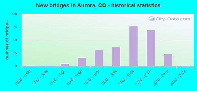
- New bridges - historical statistics
- 11930-1939
- 51950-1959
- 171960-1969
- 311970-1979
- 371980-1989
- 771990-1999
- 692000-2009
- 232010-2019
- 12020-2022

- Reconstructed bridges - Historical Statistics
- 21960-1969
- 31970-1979
- 41980-1989
- 41990-1999
- 32000-2009
- 92010-2019
- 142020-2022


- Bridge Condition - Deck
- 4.6%Very good
- 62.3%Good
- 21.5%Satisfactory
- 10.0%Fair
- 1.5%Poor

- Bridge Condition - Superstructure
- 10.8%Very good
- 60.8%Good
- 20.8%Satisfactory
- 6.9%Fair
- 0.8%Poor

- Bridge Condition - Substructure
- 3.1%Very good
- 59.2%Good
- 27.7%Satisfactory
- 10.0%Fair

- Bridge Condition - Channel
- 53.0%Very good
- 26.1%Good
- 20.9%Satisfactory

- Bridge Condition - Culverts
- 1.2%Very good
- 16.0%Good
- 72.8%Satisfactory
- 9.9%Fair
Find on map >> Show street view
Structure Number: ADA030-027.2134, Location: 0.1 MI S OF US HWY 36 (Lat: 39.754672, Lng: -104.488983), Route carried "on" structure: County highway , Year Built: 1993, Status: Open, Structure Length: 0.76m (2.49ft), Average Daily Traffic: 10 (year 2021), Average Future Daily Traffic: 14 (year 2041), Design Load: HS 20, Features Intersected: LOST CREEK TRIBUTARY, Facility Carried by Structure: SCHUMAKER ROAD
Minimum Vertical Clearance: 30+ m (98+ ft), Kilometerpoint: 0.670, Lanes on structure: 2, Owner: County Highway Agency, Approaching Roadway Width: 3.7m (12.1ft), Material/Design: Steel, Design/Construction: Stringer/Multi-beam, Number Of Spans In Main Unit: 1, Length of Maximum Span: 7.1m (23.3ft), Curb-To-Curb Width: 7.3m (24.0ft), Out-to-Out Width: 7.3m (24.0ft)
Condition: Deck: Very good, Superstructure: Good, Substructure: Good, Channel: Satisfactory, Operating Rating: 37.1 metric tons, Method Used To Determine Operating Rating: Load Factor (LF), Inventory Rating: 22.2 metric tons, Method Used To Determine Inventory Rating: Load Factor (LF), Structural Evaluation: Equal to present minimum criteria, Deck Geometry: Equal to present minimum criteria, Waterway Adequacy: Better than present minimum criteria, Approach Roadway Alignment: Equal to present desirable criteria, Designated Inspection Frequency: Every 24 months, Inspection Date: November 2021, Deck Structure Type: Corrugated Steel, Wearing Surface/Protective System: Wearing Surface: Gravel
Find on map >> Show street view
Structure Number: ADA088-27.5N131, Location: 0.5 MI WEST OF MANILA RD (Lat: 39.854778, Lng: -104.537781), Route carried "on" structure: County highway , Year Built: 1983, Year Reconstructed: 2019, Status: Open, Structure Length: 1.55m (5.09ft), Average Daily Traffic: 1,341 (year 2021), Truck Traffic: 15%, Average Future Daily Traffic: 1,743 (year 2041), Design Load: HL 93, Features Intersected: LOCAL DRAINAGE, Facility Carried by Structure: 88TH AVENUE
Minimum Vertical Clearance: 30+ m (98+ ft), Kilometerpoint: 6.843, Lanes on structure: 2, Owner: County Highway Agency, Approaching Roadway Width: 7.0m (23.0ft), Material/Design: Steel, Design/Construction: Stringer/Multi-beam, Number Of Spans In Main Unit: 1, Length of Maximum Span: 14.6m (47.9ft), Curb-To-Curb Width: 14.4m (47.2ft), Out-to-Out Width: 15.4m (50.5ft)
Condition: Deck: Very good, Superstructure: Good, Substructure: Good, Channel: Very good, Operating Rating: 65.1 metric tons, Method Used To Determine Operating Rating: Load Factor (LF) rating reported by rating factor (RF) method using MS18 loading, Inventory Rating: 50.2 metric tons, Method Used To Determine Inventory Rating: Load Factor (LF) rating reported by rating factor (RF) method using MS18 loading, Structural Evaluation: Better than present minimum criteria, Deck Geometry: Superior to present desirable criteria, Waterway Adequacy: Equal to present desirable criteria, Approach Roadway Alignment: Equal to present desirable criteria, Designated Inspection Frequency: Every 24 months, Inspection Date: December 2021, Deck Structure Type: Concrete Cast-file-Place, Wearing Surface/Protective System: Wearing Surface: Monolithic Concrete
Find on map >> Show street view
Structure Number: ADA088-28.9N129, Location: 0.9 MI E OF MANILA RD (Lat: 39.854297, Lng: -104.507989), Route carried "on" structure: County highway , Year Built: 1993, Status: Open, Structure Length: 0.76m (2.49ft), Average Daily Traffic: 1,315 (year 2021), Truck Traffic: 4%, Average Future Daily Traffic: 1,710 (year 2041), Design Load: HS 20, Features Intersected: BEAR CREEK TRIB, Facility Carried by Structure: 88TH AVENUE
Minimum Vertical Clearance: 30+ m (98+ ft), Kilometerpoint: 9.431, Lanes on structure: 2, Owner: County Highway Agency, Approaching Roadway Width: 7.0m (23.0ft), Material/Design: Steel, Design/Construction: Stringer/Multi-beam, Number Of Spans In Main Unit: 1, Length of Maximum Span: 7.1m (23.3ft), Curb-To-Curb Width: 11.0m (36.1ft), Out-to-Out Width: 11.0m (36.1ft)
Condition: Deck: Fair, Superstructure: Satisfactory, Substructure: Satisfactory, Channel: Very good, Operating Rating: 55.2 metric tons, Method Used To Determine Operating Rating: Load Factor (LF), Inventory Rating: 33.0 metric tons, Method Used To Determine Inventory Rating: Load Factor (LF), Structural Evaluation: Equal to present minimum criteria, Deck Geometry: Equal to present minimum criteria, Waterway Adequacy: Equal to present desirable criteria, Approach Roadway Alignment: Equal to present desirable criteria, Designated Inspection Frequency: Every 24 months, Inspection Date: December 2021, Deck Structure Type: Corrugated Steel, Wearing Surface/Protective System: Wearing Surface: Bituminous
Find on map >> Show street view
Structure Number: ADA25N-072.6132, Location: 1.4 MI SOUTH OF 88TH AVE (Lat: 39.835461, Lng: -104.583322), Route carried "on" structure: County highway , Year Built: 2002, Status: Open, Structure Length: 0.92m (3.02ft), Average Daily Traffic: 1,895 (year 2021), Truck Traffic: 10%, Average Future Daily Traffic: 2,463 (year 2041), Features Intersected: BEAR GULCH, Facility Carried by Structure: IMBODEN ROAD
Minimum Vertical Clearance: 30+ m (98+ ft), Kilometerpoint: 2.617, Lanes on structure: 2, Owner: County Highway Agency, Approaching Roadway Width: 7.0m (23.0ft), Material/Design: Steel, Design/Construction: Stringer/Multi-beam, Number Of Spans In Main Unit: 1, Length of Maximum Span: 8.7m (28.5ft), Curb-To-Curb Width: 7.9m (25.9ft), Out-to-Out Width: 8.5m (27.9ft)
Condition: Deck: Satisfactory, Superstructure: Satisfactory, Substructure: Satisfactory, Channel: Satisfactory, Operating Rating: 48.0 metric tons, Method Used To Determine Operating Rating: Load Factor (LF), Inventory Rating: 28.8 metric tons, Method Used To Determine Inventory Rating: Load Factor (LF), Structural Evaluation: Equal to present minimum criteria, Deck Geometry: Meets minimum limits, Waterway Adequacy: Somewhat better than minimum adequacy, Approach Roadway Alignment: Equal to present desirable criteria, Designated Inspection Frequency: Every 24 months, Inspection Date: December 2021, Deck Structure Type: Corrugated Steel, Wearing Surface/Protective System: Wearing Surface: Bituminous
Find on map >> Show street view
Structure Number: AFCOCRWU8511, Location: 0.2 miles North of Southg (Lat: 39.701472, Lng: -104.769417), Route carried "on" structure: Other road , Year Built: 1999, Status: Open, Structure Length: 1.54m (5.05ft), Average Daily Traffic: 3,400 (year 2014), Average Future Daily Traffic: 3,600 (year 2034), Features Intersected: EAST TOLLGATE CREEK, Facility Carried by Structure: ASPEN STREET
Minimum Vertical Clearance: 30+ m (98+ ft), Kilometerpoint: 0.000, Lanes on structure: 4, Owner: Air Force, Approaching Roadway Width: 18.0m (59.1ft), Material/Design: Concrete, Design/Construction: Culvert, Number Of Spans In Main Unit: 4, Length of Maximum Span: 3.7m (12.1ft), Curb or Sidewalk Widths: Left: 0.0m, Right: 1.4m (4.6ft)
Condition: Channel: Satisfactory, Culverts: Satisfactory, Operating Rating: 54.5 metric tons, Method Used To Determine Operating Rating: Field evaluation and documented engineering judgment, Inventory Rating: 32.7 metric tons, Method Used To Determine Inventory Rating: Field evaluation and documented engineering judgment, Structural Evaluation: Equal to present minimum criteria, Waterway Adequacy: Equal to present desirable criteria, Approach Roadway Alignment: Equal to present desirable criteria, Designated Inspection Frequency: Every 24 months, Inspection Date: September 2020, Bridge Improvement Cost: $40,000, Roadway Improvement Cost: $4,000, Total Project Cost: $60,000
Find on map >> Show street view
Structure Number: ARA 30-20.5, Location: 2.5 MILES E OF SH 30 (Lat: 39.638308, Lng: -104.671494), Route carried "on" structure: County highway , Year Built: 1958, Status: Open, Structure Length: 0.61m (2.00ft), Average Daily Traffic: 3,573 (year 2021), Truck Traffic: 5%, Average Future Daily Traffic: 4,359 (year 2041), Features Intersected: SENAC CREEK, Facility Carried by Structure: COUNTY ROAD 30
Minimum Vertical Clearance: 30+ m (98+ ft), Kilometerpoint: 4.076, Lanes on structure: 2, Owner: County Highway Agency, Approaching Roadway Width: 12.3m (40.4ft), Material/Design: Concrete, Design/Construction: Culvert, Number Of Spans In Main Unit: 1, Length of Maximum Span: 6.1m (20.0ft), Out-to-Out Width: 16.6m (54.5ft)
Condition: Channel: Good, Culverts: Satisfactory, Operating Rating: 36.3 metric tons, Method Used To Determine Operating Rating: Field evaluation and documented engineering judgment, Inventory Rating: 32.7 metric tons, Method Used To Determine Inventory Rating: Field evaluation and documented engineering judgment, Structural Evaluation: Equal to present minimum criteria, Waterway Adequacy: Equal to present desirable criteria, Approach Roadway Alignment: Equal to present desirable criteria, Designated Inspection Frequency: Every 24 months, Inspection Date: November 2021
Find on map >> Show street view
Structure Number: ARA 30-21.8, Location: 2.2 MI W OF WATKINS RD (Lat: 39.638433, Lng: -104.642797), Route carried "on" structure: County highway , Year Built: 1963, Status: Open, Structure Length: 3.57m (11.71ft), Average Daily Traffic: 3,573 (year 2021), Truck Traffic: 5%, Average Future Daily Traffic: 4,359 (year 2041), Features Intersected: COAL CREEK, Facility Carried by Structure: COUNTY ROAD 30
Minimum Vertical Clearance: 30+ m (98+ ft), Kilometerpoint: 6.542, Lanes on structure: 2, Owner: County Highway Agency, Approaching Roadway Width: 8.5m (27.9ft), Skew: 4 degrees, Material/Design: Prestressed concrete, Design/Construction: Tee Beam, Number Of Spans In Main Unit: 2, Length of Maximum Span: 16.6m (54.5ft), Curb-To-Curb Width: 8.6m (28.2ft), Out-to-Out Width: 10.1m (33.1ft)
Condition: Deck: Fair, Superstructure: Fair, Substructure: Satisfactory, Channel: Very good, Operating Rating: 36.3 metric tons, Method Used To Determine Operating Rating: Field evaluation and documented engineering judgment, Inventory Rating: 32.7 metric tons, Method Used To Determine Inventory Rating: Field evaluation and documented engineering judgment, Structural Evaluation: Somewhat better than minimum adequacy, Deck Geometry: Meets minimum limits, Waterway Adequacy: Equal to present minimum criteria, Approach Roadway Alignment: Better than present minimum criteria, Designated Inspection Frequency: Every 24 months, Inspection Date: November 2021, Deck Structure Type: Other, Wearing Surface/Protective System: Wearing Surface: Bituminous
Find on map >> Show street view
Structure Number: ARA 73-4.9, Location: 0.2 MI S of QUINCY AVE (Lat: 39.636056, Lng: -104.716306), Route carried "on" structure: City street _, Year Built: 2021, Status: Open, Structure Length: 0.98m (3.22ft), Average Daily Traffic: 21,850 (year 2021), Truck Traffic: 1%, Average Future Daily Traffic: 28,405 (year 2041), Design Load: HL 93, Features Intersected: TOLL GATE CREEK, Facility Carried by Structure: S GUN CLUB RD
Minimum Vertical Clearance: 30.48m (100.00ft), Kilometerpoint: 0.000, Lanes on structure: 7, Owner: City or Municipal Highway Agency, Approaching Roadway Width: 41.6m (136.5ft), Skew: 10 degrees, Material/Design: Concrete, Design/Construction: Culvert, Number Of Spans In Main Unit: 1, Length of Maximum Span: 9.8m (32.2ft), Curb or Sidewalk Widths: Left: 3.9m (12.8ft), Right: 4.2m (13.8ft), Curb-To-Curb Width: 29.6m (97.1ft), Out-to-Out Width: 41.6m (136.5ft)
Condition: Channel: Very good, Culverts: Very good, Operating Rating: 42.4 metric tons, Method Used To Determine Operating Rating: Field evaluation and documented engineering judgment, Inventory Rating: 32.7 metric tons, Method Used To Determine Inventory Rating: Field evaluation and documented engineering judgment, Structural Evaluation: Equal to present desirable criteria, Deck Geometry: Equal to present minimum criteria, Waterway Adequacy: Equal to present desirable criteria, Approach Roadway Alignment: Equal to present desirable criteria, Designated Inspection Frequency: Every 24 months, Inspection Date: November 2021, Deck Structure Type: Concrete Precast Panels, Wearing Surface/Protective System: Wearing Surface: Bituminous
Find on map >> Show street view
Structure Number: AUR-04.5-G.4, Location: 0.1 MI E OF FITZSIMMONS P (Lat: 39.744722, Lng: -104.826950), Route carried "on" structure: City street , Year Built: 2012, Status: Open, Structure Length: 18.32m (60.10ft), Average Daily Traffic: 16,966 (year 2021), Average Future Daily Traffic: 22,056 (year 2041), Design Load: HS 20, Features Intersected: TOLL GATE CREEK, Facility Carried by Structure: 17TH PLACE
Minimum Vertical Clearance: 30.45m (99.90ft), Kilometerpoint: 0.039, Lanes on structure: 6, Lanes under structure: 2, Owner: City or Municipal Highway Agency, Approaching Roadway Width: 21.9m (71.9ft), Skew: 9 degrees, Material/Design: Prestressed concrete continuous, Design/Construction: Box Beam or Girders - Single/Spread, Number Of Spans In Main Unit: 7, Length of Maximum Span: 28.0m (91.9ft), Curb-To-Curb Width: 24.4m (80.1ft), Out-to-Out Width: 25.3m (83.0ft)
Condition: Deck: Good, Superstructure: Good, Substructure: Satisfactory, Channel: Very good, Operating Rating: 72.3 metric tons, Method Used To Determine Operating Rating: Load and Resistance Factor (LRFR), Inventory Rating: 39.7 metric tons, Method Used To Determine Inventory Rating: Load and Resistance Factor (LRFR), Structural Evaluation: Equal to present minimum criteria, Deck Geometry: Somewhat better than minimum adequacy, Underclear: Better than present minimum criteria, Waterway Adequacy: Equal to present desirable criteria, Approach Roadway Alignment: Equal to present desirable criteria, Designated Inspection Frequency: Every 24 months, Inspection Date: October 2021, Deck Structure Type: Concrete Precast Panels, Wearing Surface/Protective System: Wearing Surface: Bituminous, Membrane: Built-up, Deck Protection: Epoxy Coated Reinforcing
Find on map >> Show street view
Structure Number: AUR-04.5-G.5, Location: 0.3 MI N OF COLFAX AVE (Lat: 39.744739, Lng: -104.825344), Route carried "on" structure: City street , Year Built: 2013, Status: Open, Structure Length: 5.52m (18.11ft), Average Daily Traffic: 10,438 (year 2021), Truck Traffic: 5%, Average Future Daily Traffic: 13,570 (year 2041), Design Load: HS 20, Features Intersected: I-225, Facility Carried by Structure: 17TH PLACE
Minimum Vertical Clearance: 30.45m (99.90ft), Kilometerpoint: 0.235, Lanes on structure: 4, Lanes under structure: 6, Owner: City or Municipal Highway Agency, Approaching Roadway Width: 21.9m (71.9ft), Material/Design: Prestressed concrete continuous, Design/Construction: Box Beam or Girders - Single/Spread, Number Of Spans In Main Unit: 2, Length of Maximum Span: 26.9m (88.3ft), Curb-To-Curb Width: 21.9m (71.9ft), Out-to-Out Width: 22.9m (75.1ft)
Condition: Deck: Good, Superstructure: Good, Substructure: Good, Operating Rating: 94.3 metric tons, Method Used To Determine Operating Rating: Load and Resistance Factor (LRFR), Inventory Rating: 56.6 metric tons, Method Used To Determine Inventory Rating: Load and Resistance Factor (LRFR), Structural Evaluation: Better than present minimum criteria, Deck Geometry: Superior to present desirable criteria, Underclear: Somewhat better than minimum adequacy, Approach Roadway Alignment: Equal to present desirable criteria, Designated Inspection Frequency: Every 24 months, Inspection Date: October 2021, Deck Structure Type: Concrete Precast Panels, Wearing Surface/Protective System: Wearing Surface: Bituminous, Membrane: Built-up, Deck Protection: Epoxy Coated Reinforcing
Find on map >> Show street view
Structure Number: AUR01.3-S., Location: 1.3 MI NORTH OF SMITH RD (Lat: 39.767222, Lng: -104.734606), Route carried "on" structure: City street , Year Built: 1960, Status: Posted for load, Structure Length: 0.98m (3.22ft), Average Daily Traffic: 3,433 (year 2021), Truck Traffic: 5%, Average Future Daily Traffic: 4,463 (year 2041), Features Intersected: FIRST CREEK, Facility Carried by Structure: PICADILLY ROAD
Minimum Vertical Clearance: 30+ m (98+ ft), Kilometerpoint: 2.615, Lanes on structure: 2, Owner: City or Municipal Highway Agency, Approaching Roadway Width: 8.8m (28.9ft), Material/Design: Steel, Design/Construction: Stringer/Multi-beam, Number Of Spans In Main Unit: 1, Length of Maximum Span: 9.1m (29.9ft), Curb-To-Curb Width: 9.0m (29.5ft), Out-to-Out Width: 9.2m (30.2ft)
Condition: Deck: Fair, Superstructure: Fair, Substructure: Fair, Channel: Good, Operating Rating: 26.6 metric tons, Method Used To Determine Operating Rating: Load Factor (LF), Inventory Rating: 15.9 metric tons, Method Used To Determine Inventory Rating: Load Factor (LF), Structural Evaluation: Meets minimum limits, Deck Geometry: Meets minimum limits, Waterway Adequacy: Equal to present minimum criteria, Approach Roadway Alignment: Equal to present desirable criteria, Bridge Posting: Required (Relationship of Operating Rating to Maximum Legal Load: 10.0 - 19.9% below), Designated Inspection Frequency: Every 24 months, Inspection Date: October 2021, Deck Structure Type: Corrugated Steel, Wearing Surface/Protective System: Wearing Surface: Bituminous
Find on map >> Show street view
Structure Number: AUR01.5-F0.4, Location: 0.25 MI E OF SCRANTON (Lat: 39.765692, Lng: -104.833383), Route carried "on" structure: City street , Year Built: 2014, Status: Open, Structure Length: 0.76m (2.49ft), Average Daily Traffic: 1,787 (year 2021), Truck Traffic: 25%, Average Future Daily Traffic: 2,323 (year 2041), Features Intersected: LOCAL DRAINAGE, Facility Carried by Structure: SMITH ROAD
Minimum Vertical Clearance: 30+ m (98+ ft), Kilometerpoint: 1.513, Lanes on structure: 2, Owner: City or Municipal Highway Agency, Approaching Roadway Width: 11.0m (36.1ft), Material/Design: Concrete, Design/Construction: Culvert, Number Of Spans In Main Unit: 3, Length of Maximum Span: 2.0m (6.6ft), Curb or Sidewalk Widths: Left: 0.0m, Right: 2.4m (7.9ft), Out-to-Out Width: 54.6m (179.1ft)
Condition: Channel: Very good, Culverts: Good, Operating Rating: 36.3 metric tons, Method Used To Determine Operating Rating: Field evaluation and documented engineering judgment, Inventory Rating: 32.7 metric tons, Method Used To Determine Inventory Rating: Field evaluation and documented engineering judgment, Structural Evaluation: Better than present minimum criteria, Waterway Adequacy: Equal to present desirable criteria, Approach Roadway Alignment: Equal to present desirable criteria, Designated Inspection Frequency: Every 24 months, Inspection Date: October 2021
Find on map >> Show street view
Structure Number: AUR01.9-AE., Location: .6 MI N OF 26TH AVENUE (Lat: 39.762367, Lng: -104.621681), Route carried "on" structure: City street , Year Built: 1960, Year Reconstructed: 2018, Status: Open, Structure Length: 0.93m (3.05ft), Average Daily Traffic: 993 (year 2021), Average Future Daily Traffic: 1,291 (year 2041), Design Load: HS 20, Features Intersected: COYOTE RUN, Facility Carried by Structure: HUDSON ROAD
Minimum Vertical Clearance: 30+ m (98+ ft), Kilometerpoint: 2.340, Lanes on structure: 2, Owner: City or Municipal Highway Agency, Approaching Roadway Width: 7.3m (24.0ft), Material/Design: Steel, Design/Construction: Stringer/Multi-beam, Number Of Spans In Main Unit: 1, Length of Maximum Span: 8.5m (27.9ft), Curb or Sidewalk Widths: Left: 0.5m (1.6ft), Right: 0.5m (1.6ft), Curb-To-Curb Width: 9.1m (29.9ft), Out-to-Out Width: 10.1m (33.1ft)
Condition: Deck: Very good, Superstructure: Good, Substructure: Good, Channel: Very good, Operating Rating: 80.4 metric tons, Method Used To Determine Operating Rating: Load Factor (LF), Inventory Rating: 48.1 metric tons, Method Used To Determine Inventory Rating: Load Factor (LF), Structural Evaluation: Better than present minimum criteria, Deck Geometry: Equal to present minimum criteria, Waterway Adequacy: Better than present minimum criteria, Approach Roadway Alignment: Equal to present desirable criteria, Designated Inspection Frequency: Every 24 months, Inspection Date: October 2021, Deck Structure Type: Concrete Cast-file-Place, Wearing Surface/Protective System: Wearing Surface: Bituminous, Membrane: Built-up, Deck Protection: Epoxy Coated Reinforcing
Find on map >> Show street view
Structure Number: AUR01.9-E., Location: PEORIA and BARANMOR PKWY (Lat: 39.762433, Lng: -104.846825), Route carried "on" structure: County highway , Year Built: 2014, Status: Open, Structure Length: 1.04m (3.41ft), Average Daily Traffic: 25,984 (year 2021), Truck Traffic: 20%, Average Future Daily Traffic: 33,779 (year 2041), Design Load: HL 93, Features Intersected: BARANMOR DITCH, Facility Carried by Structure: PEORIA STREET
Minimum Vertical Clearance: 0.00m, Kilometerpoint: 0.011, Lanes on structure: 8, Owner: City or Municipal Highway Agency, Approaching Roadway Width: 28.7m (94.2ft), Skew: 9 degrees, Material/Design: Concrete, Design/Construction: Culvert, Number Of Spans In Main Unit: 2, Length of Maximum Span: 4.9m (16.1ft), Out-to-Out Width: 135.6m (444.9ft)
Condition: Channel: Very good, Culverts: Satisfactory, Operating Rating: 55.5 metric tons, Method Used To Determine Operating Rating: Load and Resistance Factor (LRFR), Inventory Rating: 42.5 metric tons, Method Used To Determine Inventory Rating: Load and Resistance Factor (LRFR), Structural Evaluation: Equal to present minimum criteria, Waterway Adequacy: Equal to present desirable criteria, Approach Roadway Alignment: Equal to present desirable criteria, Designated Inspection Frequency: Every 24 months, Inspection Date: November 2021
Find on map >> Show street view
Structure Number: AUR01.9-E.3-A, Location: JUST N OF BARANMOOR PKWY (Lat: 39.762628, Lng: -104.844503), Route carried "on" structure: City street , Year Built: 2016, Status: Open, Structure Length: 1.27m (4.17ft), Average Daily Traffic: 332 (year 2021), Truck Traffic: 2%, Average Future Daily Traffic: 432 (year 2041), Design Load: HS 20, Features Intersected: LOCAL DRAINAGE, Facility Carried by Structure: QUENTIN ST
Minimum Vertical Clearance: 30+ m (98+ ft), Kilometerpoint: 0.023, Lanes on structure: 2, Owner: City or Municipal Highway Agency, Approaching Roadway Width: 12.2m (40.0ft), Material/Design: Concrete, Design/Construction: Culvert, Number Of Spans In Main Unit: 2, Length of Maximum Span: 6.1m (20.0ft), Curb or Sidewalk Widths: Left: 2.0m (6.6ft), Right: 2.0m (6.6ft), Out-to-Out Width: 16.4m (53.8ft)
Condition: Channel: Very good, Culverts: Good, Operating Rating: 48.5 metric tons, Method Used To Determine Operating Rating: Load Factor (LF), Inventory Rating: 29.1 metric tons, Method Used To Determine Inventory Rating: Load Factor (LF), Structural Evaluation: Better than present minimum criteria, Waterway Adequacy: Better than present minimum criteria, Approach Roadway Alignment: Equal to present desirable criteria, Designated Inspection Frequency: Every 24 months, Inspection Date: October 2021
Find on map >> Show street view
Structure Number: AUR02.7-E., Location: 0.1 MI N OF MONTVIEW BLVD (Lat: 39.756703, Lng: -104.846917), Route carried "on" structure: City street , Year Built: 1966, Status: Open, Structure Length: 9.33m (30.61ft), Average Daily Traffic: 33,268 (year 2021), Truck Traffic: 5%, Average Future Daily Traffic: 43,249 (year 2041), Design Load: HS 20, Features Intersected: SAND CREEK, Facility Carried by Structure: PEORIA STREET
Minimum Vertical Clearance: 30+ m (98+ ft), Kilometerpoint: 3.317, Lanes on structure: 4, Owner: City or Municipal Highway Agency, Approaching Roadway Width: 23.8m (78.1ft), Material/Design: Prestressed concrete continuous, Design/Construction: Stringer/Multi-beam, Number Of Spans In Main Unit: 3, Length of Maximum Span: 30.3m (99.4ft), Curb or Sidewalk Widths: Left: 1.5m (4.9ft), Right: 1.5m (4.9ft), Curb-To-Curb Width: 15.9m (52.2ft), Out-to-Out Width: 18.9m (62.0ft)
Condition: Deck: Satisfactory, Superstructure: Satisfactory, Substructure: Good, Channel: Good, Operating Rating: 58.9 metric tons, Method Used To Determine Operating Rating: Load Factor (LF), Inventory Rating: 15.7 metric tons, Method Used To Determine Inventory Rating: Load Factor (LF), Structural Evaluation: High priority of corrective action, Deck Geometry: Meets minimum limits, Waterway Adequacy: Equal to present desirable criteria, Approach Roadway Alignment: Equal to present desirable criteria, Length Of Structure Improvement: 9.33m (30.61ft), Designated Inspection Frequency: Every 24 months, Inspection Date: October 2021, Deck Structure Type: Concrete Cast-file-Place, Wearing Surface/Protective System: Wearing Surface: Bituminous, Membrane: Built-up
Find on map >> Show street view
Structure Number: AUR02.7-H., Location: JUST NORTH OF 28TH AVE (Lat: 39.756614, Lng: -104.819433), Route carried "on" structure: City street , Year Built: 1975, Status: Open, Structure Length: 5.64m (18.50ft), Average Daily Traffic: 9,902 (year 2021), Truck Traffic: 4%, Average Future Daily Traffic: 12,873 (year 2041), Design Load: HS 20, Features Intersected: SAND CREEK, Facility Carried by Structure: SABLE BLVD
Minimum Vertical Clearance: 30+ m (98+ ft), Kilometerpoint: 3.460, Lanes on structure: 2, Owner: City or Municipal Highway Agency, Approaching Roadway Width: 15.2m (49.9ft), Material/Design: Prestressed concrete continuous, Design/Construction: Slab, Number Of Spans In Main Unit: 3, Length of Maximum Span: 20.3m (66.6ft), Curb or Sidewalk Widths: Left: 2.6m (8.5ft), Right: 0.0m, Curb-To-Curb Width: 15.2m (49.9ft), Out-to-Out Width: 18.8m (61.7ft)
Condition: Deck: Good, Superstructure: Good, Substructure: Good, Channel: Satisfactory, Operating Rating: 50.6 metric tons, Method Used To Determine Operating Rating: Load Factor (LF), Inventory Rating: 37.0 metric tons, Method Used To Determine Inventory Rating: Load Factor (LF), Structural Evaluation: Better than present minimum criteria, Deck Geometry: Superior to present desirable criteria, Waterway Adequacy: Equal to present desirable criteria, Approach Roadway Alignment: Equal to present desirable criteria, Designated Inspection Frequency: Every 24 months, Inspection Date: October 2021, Deck Structure Type: Concrete Cast-file-Place, Wearing Surface/Protective System: Wearing Surface: Bituminous, Membrane: Built-up
Find on map >> Show street view
Structure Number: AUR03.1-J., Location: JUST SOUTH OF 28TH AVE (Lat: 39.753708, Lng: -104.810047), Route carried "on" structure: City street , Year Built: 1973, Status: Open, Structure Length: 6.40m (21.00ft), Average Daily Traffic: 11,649 (year 2021), Truck Traffic: 5%, Average Future Daily Traffic: 15,144 (year 2041), Design Load: HS 20, Features Intersected: SAND CREEK, Facility Carried by Structure: CHAMBERS ROAD
Minimum Vertical Clearance: 30+ m (98+ ft), Kilometerpoint: 15.678, Lanes on structure: 6, Base Highway Network: Yes, Owner: City or Municipal Highway Agency, Approaching Roadway Width: 20.7m (67.9ft), Skew: 32 degrees, Material/Design: Prestressed concrete, Design/Construction: Tee Beam, Number Of Spans In Main Unit: 3, Length of Maximum Span: 21.0m (68.9ft), Curb or Sidewalk Widths: Left: 2.8m (9.2ft), Right: 3.1m (10.2ft), Curb-To-Curb Width: 20.7m (67.9ft), Out-to-Out Width: 33.7m (110.6ft)
Condition: Deck: Good, Superstructure: Satisfactory, Substructure: Satisfactory, Channel: Good, Operating Rating: 45.4 metric tons, Method Used To Determine Operating Rating: Load Factor (LF), Inventory Rating: 33.9 metric tons, Method Used To Determine Inventory Rating: Load Factor (LF), Structural Evaluation: Equal to present minimum criteria, Deck Geometry: High priority of replacement, Waterway Adequacy: Equal to present desirable criteria, Approach Roadway Alignment: Equal to present desirable criteria, Length Of Structure Improvement: 7.45m (24.44ft), Designated Inspection Frequency: Every 24 months, Inspection Date: October 2021, Deck Structure Type: Concrete Cast-file-Place, Wearing Surface/Protective System: Wearing Surface: Bituminous
Find on map >> Show street view
Structure Number: AUR03.3-T.5, Location: 0.2 MI W of E-470 (Lat: 39.748858, Lng: -104.720728), Route carried "on" structure: City street , Year Built: 2015, Status: Open, Structure Length: 2.31m (7.58ft), Average Daily Traffic: 2,886 (year 2021), Truck Traffic: 4%, Average Future Daily Traffic: 3,751 (year 2041), Features Intersected: FIRST CREEK, Facility Carried by Structure: SMITH ROAD
Minimum Vertical Clearance: 30+ m (98+ ft), Kilometerpoint: 11.022, Lanes on structure: 4, Owner: City or Municipal Highway Agency, Approaching Roadway Width: 17.5m (57.4ft), Material/Design: Concrete, Design/Construction: Culvert, Number Of Spans In Main Unit: 7, Length of Maximum Span: 3.1m (10.2ft), Curb or Sidewalk Widths: Left: 0.0m, Right: 3.0m (9.8ft), Curb-To-Curb Width: 17.5m (57.4ft), Out-to-Out Width: 23.9m (78.4ft)
Condition: Channel: Very good, Culverts: Good, Operating Rating: 36.3 metric tons, Method Used To Determine Operating Rating: Field evaluation and documented engineering judgment, Inventory Rating: 32.7 metric tons, Method Used To Determine Inventory Rating: Field evaluation and documented engineering judgment, Structural Evaluation: Better than present minimum criteria, Deck Geometry: Somewhat better than minimum adequacy, Waterway Adequacy: Equal to present desirable criteria, Approach Roadway Alignment: Equal to present desirable criteria, Designated Inspection Frequency: Every 24 months, Inspection Date: November 2021
Find on map >> Show street view
Structure Number: AUR03.5-A.5, Location: 17TH AVE AND BEELER ST (Lat: 39.743786, Lng: -104.880978), Route carried "on" structure: City street , Year Built: 1981, Status: Open, Structure Length: 0.71m (2.33ft), Average Daily Traffic: 1,409 (year 2021), Truck Traffic: 3%, Average Future Daily Traffic: 1,832 (year 2041), Design Load: HS 20, Features Intersected: WESTERLY GULCH, Facility Carried by Structure: 17TH AVENUE
Minimum Vertical Clearance: 30+ m (98+ ft), Kilometerpoint: 0.311, Lanes on structure: 2, Owner: City or Municipal Highway Agency, Approaching Roadway Width: 12.2m (40.0ft), Skew: 3 degrees, Material/Design: Concrete, Design/Construction: Culvert, Number Of Spans In Main Unit: 2, Length of Maximum Span: 3.4m (11.2ft), Curb or Sidewalk Widths: Left: 1.0m (3.3ft), Right: 1.0m (3.3ft), Out-to-Out Width: 22.5m (73.8ft)
Condition: Channel: Very good, Culverts: Satisfactory, Operating Rating: 36.3 metric tons, Method Used To Determine Operating Rating: Field evaluation and documented engineering judgment, Inventory Rating: 32.7 metric tons, Method Used To Determine Inventory Rating: Field evaluation and documented engineering judgment, Structural Evaluation: Equal to present minimum criteria, Waterway Adequacy: Equal to present desirable criteria, Approach Roadway Alignment: Equal to present desirable criteria, Designated Inspection Frequency: Every 24 months, Inspection Date: October 2021
Find on map >> Show street view
Structure Number: AUR03.5-N., Location: JUST S OF 22ND PL (Lat: 39.750236, Lng: -104.772406), Route carried "on" structure: City street , Year Built: 1981, Status: Open, Structure Length: 0.66m (2.17ft), Average Daily Traffic: 14,612 (year 2021), Truck Traffic: 6%, Average Future Daily Traffic: 18,995 (year 2041), Design Load: HS 20, Features Intersected: LOCAL DRAINAGE, Facility Carried by Structure: TOWER ROAD
Minimum Vertical Clearance: 30+ m (98+ ft), Kilometerpoint: 1.497, Lanes on structure: 2, Owner: City or Municipal Highway Agency, Approaching Roadway Width: 10.3m (33.8ft), Skew: 1 degrees, Material/Design: Steel, Design/Construction: Culvert, Number Of Spans In Main Unit: 2, Length of Maximum Span: 2.8m (9.2ft), Out-to-Out Width: 23.6m (77.4ft)
Condition: Channel: Good, Culverts: Satisfactory, Operating Rating: 73.5 metric tons, Method Used To Determine Operating Rating: Load and Resistance Factor (LRFR), Inventory Rating: 56.4 metric tons, Method Used To Determine Inventory Rating: Load and Resistance Factor (LRFR), Structural Evaluation: Equal to present minimum criteria, Waterway Adequacy: Equal to present desirable criteria, Approach Roadway Alignment: Equal to present desirable criteria, Designated Inspection Frequency: Every 24 months, Inspection Date: October 2021
Find on map >> Show street view
Structure Number: AUR03.6-H.2, Location: JUST S OF 23RD AVE (Lat: 39.750919, Lng: -104.819444), Route carried "on" structure: City street , Year Built: 1992, Status: Open, Structure Length: 0.66m (2.17ft), Average Daily Traffic: 9,528 (year 2021), Truck Traffic: 4%, Average Future Daily Traffic: 12,386 (year 2041), Design Load: HS 20, Features Intersected: SABLE DITCH, Facility Carried by Structure: SABLE BLVD
Minimum Vertical Clearance: 30+ m (98+ ft), Kilometerpoint: 2.852, Lanes on structure: 2, Owner: City or Municipal Highway Agency, Approaching Roadway Width: 15.1m (49.5ft), Skew: 2 degrees, Material/Design: Concrete, Design/Construction: Culvert, Number Of Spans In Main Unit: 2, Length of Maximum Span: 3.0m (9.8ft), Curb or Sidewalk Widths: Left: 1.5m (4.9ft), Right: 1.5m (4.9ft), Out-to-Out Width: 29.2m (95.8ft)
Condition: Channel: Very good, Culverts: Good, Operating Rating: 63.1 metric tons, Method Used To Determine Operating Rating: Load Factor (LF), Inventory Rating: 37.7 metric tons, Method Used To Determine Inventory Rating: Load Factor (LF), Structural Evaluation: Better than present minimum criteria, Waterway Adequacy: Equal to present desirable criteria, Approach Roadway Alignment: Equal to present desirable criteria, Designated Inspection Frequency: Every 48 months, Inspection Date: October 2019
Find on map >> Show street view
Structure Number: AUR03.6-H.3, Location: E OF SABLE AND S OF 23R (Lat: 39.750111, Lng: -104.817033), Route carried "on" structure: City street , Year Built: 1981, Status: Open, Structure Length: 0.73m (2.40ft), Average Daily Traffic: 136 (year 2021), Average Future Daily Traffic: 177 (year 2041), Features Intersected: SABLE DITCH, Facility Carried by Structure: EAGLE STREET
Minimum Vertical Clearance: 30+ m (98+ ft), Kilometerpoint: 0.094, Lanes on structure: 2, Owner: City or Municipal Highway Agency, Approaching Roadway Width: 12.2m (40.0ft), Skew: 3 degrees, Material/Design: Concrete, Design/Construction: Culvert, Number Of Spans In Main Unit: 2, Length of Maximum Span: 3.5m (11.5ft), Curb or Sidewalk Widths: Left: 1.4m (4.6ft), Right: 1.4m (4.6ft), Out-to-Out Width: 19.6m (64.3ft)
Condition: Channel: Very good, Culverts: Satisfactory, Operating Rating: 79.6 metric tons, Method Used To Determine Operating Rating: Load Factor (LF), Inventory Rating: 47.6 metric tons, Method Used To Determine Inventory Rating: Load Factor (LF), Structural Evaluation: Equal to present minimum criteria, Waterway Adequacy: Equal to present desirable criteria, Approach Roadway Alignment: Equal to present desirable criteria, Designated Inspection Frequency: Every 24 months, Inspection Date: October 2021
Find on map >> Show street view
Structure Number: AUR03.6-H.4, Location: W OF CHAMBERS & S OF (Lat: 39.749914, Lng: -104.815825), Route carried "on" structure: City street , Year Built: 1981, Status: Open, Structure Length: 0.70m (2.30ft), Average Daily Traffic: 74 (year 2021), Average Future Daily Traffic: 97 (year 2041), Features Intersected: SABLE DITCH, Facility Carried by Structure: ELKHART STREET
Minimum Vertical Clearance: 30+ m (98+ ft), Kilometerpoint: 0.071, Lanes on structure: 2, Owner: City or Municipal Highway Agency, Approaching Roadway Width: 9.1m (29.9ft), Skew: 3 degrees, Material/Design: Concrete, Design/Construction: Culvert, Number Of Spans In Main Unit: 2, Length of Maximum Span: 3.4m (11.2ft), Out-to-Out Width: 18.9m (62.0ft)
Condition: Channel: Good, Culverts: Good, Operating Rating: 49.9 metric tons, Method Used To Determine Operating Rating: Load Factor (LF), Inventory Rating: 29.8 metric tons, Method Used To Determine Inventory Rating: Load Factor (LF), Structural Evaluation: Better than present minimum criteria, Waterway Adequacy: Equal to present desirable criteria, Approach Roadway Alignment: Equal to present desirable criteria, Designated Inspection Frequency: Every 24 months, Inspection Date: October 2021
Find on map >> Show street view
Structure Number: AUR03.7-H.6, Location: 2 BLOCKS WEST OF CHAMBERS (Lat: 39.749097, Lng: -104.813325), Route carried "on" structure: City street , Year Built: 1981, Status: Open, Structure Length: 0.84m (2.76ft), Average Daily Traffic: 462 (year 2021), Truck Traffic: 2%, Average Future Daily Traffic: 601 (year 2041), Features Intersected: SABLE DITCH, Facility Carried by Structure: 22ND AVENUE
Minimum Vertical Clearance: 30+ m (98+ ft), Kilometerpoint: 0.121, Lanes on structure: 2, Owner: City or Municipal Highway Agency, Approaching Roadway Width: 12.2m (40.0ft), Skew: 5 degrees, Material/Design: Concrete, Design/Construction: Culvert, Number Of Spans In Main Unit: 2, Length of Maximum Span: 4.1m (13.5ft), Curb or Sidewalk Widths: Left: 1.4m (4.6ft), Right: 1.4m (4.6ft), Out-to-Out Width: 18.9m (62.0ft)
Condition: Channel: Good, Culverts: Good, Operating Rating: 51.0 metric tons, Method Used To Determine Operating Rating: Load Factor (LF), Inventory Rating: 30.5 metric tons, Method Used To Determine Inventory Rating: Load Factor (LF), Structural Evaluation: Better than present minimum criteria, Waterway Adequacy: Equal to present desirable criteria, Approach Roadway Alignment: Equal to present desirable criteria, Designated Inspection Frequency: Every 24 months, Inspection Date: October 2021
Find on map >> Show street view
Structure Number: AUR03.7-M.7, Location: 0.1 MI WEST OF TOWER RD (Lat: 39.749167, Lng: -104.774764), Route carried "on" structure: City street , Year Built: 1981, Status: Open, Structure Length: 0.64m (2.10ft), Average Daily Traffic: 1,442 (year 2021), Truck Traffic: 8%, Average Future Daily Traffic: 1,875 (year 2041), Design Load: HS 20+Mod, Features Intersected: LOCAL DRAINAGE, Facility Carried by Structure: 22ND AVENUE
Minimum Vertical Clearance: 30+ m (98+ ft), Kilometerpoint: 1.426, Lanes on structure: 2, Owner: City or Municipal Highway Agency, Approaching Roadway Width: 15.2m (49.9ft), Material/Design: Steel, Design/Construction: Culvert, Number Of Spans In Main Unit: 2, Length of Maximum Span: 2.7m (8.9ft), Curb-To-Curb Width: 15.2m (49.9ft), Out-to-Out Width: 21.5m (70.5ft)
Condition: Channel: Good, Culverts: Satisfactory, Structural Evaluation: Equal to present minimum criteria, Deck Geometry: Superior to present desirable criteria, Waterway Adequacy: Equal to present desirable criteria, Approach Roadway Alignment: Equal to present desirable criteria, Designated Inspection Frequency: Every 24 months, Inspection Date: October 2021
Find on map >> Show street view
Structure Number: AUR03.9-K.99, Location: 0.5 MI NORTH OF COLFAX (Lat: 39.747894, Lng: -104.791378), Route carried "on" structure: City street , Year Built: 1991, Status: Open, Structure Length: 6.22m (20.41ft), Average Daily Traffic: 16,295 (year 2021), Truck Traffic: 6%, Average Future Daily Traffic: 21,184 (year 2041), Design Load: HS 20, Features Intersected: SAND CREEK, Facility Carried by Structure: SB AIRPORT BLVD
Minimum Vertical Clearance: 30+ m (98+ ft), Kilometerpoint: 4.553, Lanes on structure: 3, Owner: City or Municipal Highway Agency, Approaching Roadway Width: 11.0m (36.1ft), Skew: 20 degrees, Material/Design: Prestressed concrete continuous, Design/Construction: Box Beam or Girders - Multiple, Number Of Spans In Main Unit: 2, Length of Maximum Span: 29.5m (96.8ft), Curb or Sidewalk Widths: Left: 2.1m (6.9ft), Right: 0.0m, Curb-To-Curb Width: 11.0m (36.1ft), Out-to-Out Width: 16.8m (55.1ft)
Condition: Deck: Good, Superstructure: Satisfactory, Substructure: Good, Channel: Good, Operating Rating: 61.8 metric tons, Method Used To Determine Operating Rating: Load Factor (LF), Inventory Rating: 36.9 metric tons, Method Used To Determine Inventory Rating: Load Factor (LF), Structural Evaluation: Equal to present minimum criteria, Deck Geometry: High priority of replacement, Waterway Adequacy: Equal to present desirable criteria, Approach Roadway Alignment: Equal to present desirable criteria, Length Of Structure Improvement: 6.22m (20.41ft), Designated Inspection Frequency: Every 24 months, Inspection Date: October 2021, Deck Structure Type: Concrete Cast-file-Place, Wearing Surface/Protective System: Wearing Surface: Bituminous, Membrane: Built-up
Find on map >> Show street view
Structure Number: AUR03.9-L.01, Location: 0.5 MI NORTH OF COLFAX (Lat: 39.747889, Lng: -104.791181), Route carried "on" structure: City street , Year Built: 1991, Status: Open, Structure Length: 6.22m (20.41ft), Average Daily Traffic: 16,295 (year 2021), Truck Traffic: 6%, Average Future Daily Traffic: 21,184 (year 2041), Design Load: HS 20, Features Intersected: SAND CREEK, Facility Carried by Structure: NB AIRPORT BLVD
Minimum Vertical Clearance: 30+ m (98+ ft), Kilometerpoint: 4.553, Lanes on structure: 3, Owner: City or Municipal Highway Agency, Approaching Roadway Width: 11.0m (36.1ft), Skew: 20 degrees, Material/Design: Prestressed concrete continuous, Design/Construction: Box Beam or Girders - Multiple, Number Of Spans In Main Unit: 2, Length of Maximum Span: 29.4m (96.5ft), Curb or Sidewalk Widths: Left: 0.0m, Right: 3.0m (9.8ft), Curb-To-Curb Width: 11.0m (36.1ft), Out-to-Out Width: 17.7m (58.1ft)
Condition: Deck: Good, Superstructure: Good, Substructure: Good, Channel: Good, Operating Rating: 59.5 metric tons, Method Used To Determine Operating Rating: Load Factor (LF), Inventory Rating: 31.7 metric tons, Method Used To Determine Inventory Rating: Load Factor (LF), Structural Evaluation: Better than present minimum criteria, Deck Geometry: High priority of replacement, Waterway Adequacy: Equal to present desirable criteria, Approach Roadway Alignment: Equal to present desirable criteria, Length Of Structure Improvement: 7.27m (23.85ft), Designated Inspection Frequency: Every 24 months, Inspection Date: October 2021, Deck Structure Type: Concrete Cast-file-Place, Wearing Surface/Protective System: Wearing Surface: Bituminous, Membrane: Built-up
Find on map >> Show street view
Structure Number: AUR03.9-R., Location: AIRPORT BLVD OVER I-70 (Lat: 39.765800, Lng: -104.791100), Route carried "on" structure: City street , Year Built: 1993, Status: Open, Structure Length: 11.28m (37.01ft), Average Daily Traffic: 25,514 (year 2021), Truck Traffic: 6%, Average Future Daily Traffic: 33,168 (year 2041), Design Load: HS 20+Mod, Features Intersected: I-70, Facility Carried by Structure: AIRPORT BLVD
Minimum Vertical Clearance: 30+ m (98+ ft), Kilometerpoint: 6.565, Lanes on structure: 8, Lanes under structure: 6, Owner: City or Municipal Highway Agency, Approaching Roadway Width: 32.0m (105.0ft), Skew: 32 degrees, Material/Design: Prestressed concrete continuous, Design/Construction: Stringer/Multi-beam, Number Of Spans In Main Unit: 4, Length of Maximum Span: 28.7m (94.2ft), Curb or Sidewalk Widths: Left: 3.0m (9.8ft), Right: 3.0m (9.8ft), Curb-To-Curb Width: 31.1m (102.0ft), Out-to-Out Width: 44.8m (147.0ft)
Condition: Deck: Satisfactory, Superstructure: Good, Substructure: Good, Operating Rating: 62.3 metric tons, Method Used To Determine Operating Rating: Load Factor (LF), Inventory Rating: 33.1 metric tons, Method Used To Determine Inventory Rating: Load Factor (LF), Structural Evaluation: Better than present minimum criteria, Deck Geometry: Somewhat better than minimum adequacy, Underclear: Meets minimum limits, Approach Roadway Alignment: Equal to present desirable criteria, Designated Inspection Frequency: Every 24 months, Inspection Date: October 2021, Deck Structure Type: Concrete Precast Panels, Wearing Surface/Protective System: Wearing Surface: Monolithic Concrete, Deck Protection: Epoxy Coated Reinforcing
Find on map >> Show street view
Structure Number: AUR04.0-A.5, Location: 0.26 MI E OF YOSEMITE (Lat: 39.747447, Lng: -104.879939), Route carried "on" structure: City street , Year Built: 2014, Status: Open, Structure Length: 2.19m (7.19ft), Average Daily Traffic: 10,906 (year 2021), Truck Traffic: 10%, Average Future Daily Traffic: 14,177 (year 2041), Design Load: HL 93, Features Intersected: WESTERLY CREEK, Facility Carried by Structure: WB MONTVIEW BLVD
Minimum Vertical Clearance: 30.45m (99.90ft), Kilometerpoint: 0.216, Lanes on structure: 2, Owner: City or Municipal Highway Agency, Approaching Roadway Width: 8.8m (28.9ft), Skew: 1 degrees, Material/Design: Prestressed concrete, Design/Construction: Box Beam or Girders - Multiple, Number Of Spans In Main Unit: 1, Length of Maximum Span: 18.3m (60.0ft), Curb or Sidewalk Widths: Left: 3.0m (9.8ft), Right: 0.0m, Curb-To-Curb Width: 8.8m (28.9ft), Out-to-Out Width: 12.8m (42.0ft)
Condition: Deck: Good, Superstructure: Very good, Substructure: Good, Channel: Very good, Operating Rating: 55.5 metric tons, Method Used To Determine Operating Rating: Load and Resistance Factor (LRFR), Inventory Rating: 39.2 metric tons, Method Used To Determine Inventory Rating: Load and Resistance Factor (LRFR), Structural Evaluation: Better than present minimum criteria, Deck Geometry: High priority of corrective action, Waterway Adequacy: Equal to present desirable criteria, Approach Roadway Alignment: Equal to present desirable criteria, Designated Inspection Frequency: Every 24 months, Inspection Date: November 2021, Deck Structure Type: Concrete Cast-file-Place, Wearing Surface/Protective System: Wearing Surface: Bituminous, Membrane: Other, Deck Protection: Epoxy Coated Reinforcing
Find on map >> Show street view
Structure Number: AUR04.0-H.7, Location: INT MONTVIEW AND FRASER (Lat: 39.747292, Lng: -104.812336), Route carried "on" structure: City street , Year Built: 1981, Status: Open, Structure Length: 0.93m (3.05ft), Average Daily Traffic: 1,830 (year 2021), Truck Traffic: 2%, Average Future Daily Traffic: 2,380 (year 2041), Features Intersected: SABLE DITCH, Facility Carried by Structure: MONTVIEW BLVD
Minimum Vertical Clearance: 30+ m (98+ ft), Kilometerpoint: 0.392, Lanes on structure: 2, Owner: City or Municipal Highway Agency, Approaching Roadway Width: 8.8m (28.9ft), Skew: 5 degrees, Material/Design: Concrete, Design/Construction: Culvert, Number Of Spans In Main Unit: 2, Length of Maximum Span: 4.5m (14.8ft), Out-to-Out Width: 20.6m (67.6ft)
Condition: Channel: Satisfactory, Culverts: Satisfactory, Operating Rating: 34.5 metric tons, Method Used To Determine Operating Rating: Load Factor (LF), Inventory Rating: 20.7 metric tons, Method Used To Determine Inventory Rating: Load Factor (LF), Structural Evaluation: Somewhat better than minimum adequacy, Waterway Adequacy: Equal to present desirable criteria, Approach Roadway Alignment: Equal to present desirable criteria, Designated Inspection Frequency: Every 24 months, Inspection Date: October 2021
Find on map >> Show street view
Structure Number: AUR04.02-A.5, Location: 0.26 MI E OF YOSEMITE ST. (Lat: 39.747311, Lng: -104.879872), Route carried "on" structure: City street , Year Built: 2014, Status: Open, Structure Length: 2.19m (7.19ft), Average Daily Traffic: 10,147 (year 2021), Truck Traffic: 5%, Average Future Daily Traffic: 13,191 (year 2041), Features Intersected: WESTERLY CREEK, Facility Carried by Structure: EB MONTVIEW BLVD
Minimum Vertical Clearance: 30.45m (99.90ft), Kilometerpoint: 0.222, Lanes on structure: 2, Owner: City or Municipal Highway Agency, Approaching Roadway Width: 8.8m (28.9ft), Skew: 1 degrees, Material/Design: Prestressed concrete, Design/Construction: Box Beam or Girders - Multiple, Number Of Spans In Main Unit: 1, Length of Maximum Span: 18.3m (60.0ft), Curb or Sidewalk Widths: Left: 0.0m, Right: 2.4m (7.9ft), Curb-To-Curb Width: 8.8m (28.9ft), Out-to-Out Width: 12.8m (42.0ft)
Condition: Deck: Good, Superstructure: Very good, Substructure: Good, Channel: Very good, Operating Rating: 81.6 metric tons, Method Used To Determine Operating Rating: Load and Resistance Factor (LRFR), Inventory Rating: 58.8 metric tons, Method Used To Determine Inventory Rating: Load and Resistance Factor (LRFR), Structural Evaluation: Better than present minimum criteria, Deck Geometry: High priority of corrective action, Waterway Adequacy: Equal to present desirable criteria, Approach Roadway Alignment: Equal to present desirable criteria, Designated Inspection Frequency: Every 24 months, Inspection Date: November 2021, Deck Structure Type: Concrete Cast-file-Place, Wearing Surface/Protective System: Wearing Surface: Bituminous, Membrane: Other, Deck Protection: Epoxy Coated Reinforcing
Find on map >> Show street view
Structure Number: AUR04.2-J., Location: 0.1 MI N OF 18TH STREET (Lat: 39.746097, Lng: -104.809856), Route carried "on" structure: City street , Year Built: 1981, Status: Open, Structure Length: 0.62m (2.03ft), Average Daily Traffic: 9,547 (year 2021), Truck Traffic: 5%, Average Future Daily Traffic: 12,411 (year 2041), Features Intersected: SABLE DITCH, Facility Carried by Structure: CHAMBERS RD
Minimum Vertical Clearance: 30+ m (98+ ft), Kilometerpoint: 14.875, Lanes on structure: 6, Base Highway Network: Yes, Owner: City or Municipal Highway Agency, Approaching Roadway Width: 19.5m (64.0ft), Skew: 39 degrees, Material/Design: Concrete, Design/Construction: Culvert, Number Of Spans In Main Unit: 2, Length of Maximum Span: 3.0m (9.8ft), Curb or Sidewalk Widths: Left: 1.4m (4.6ft), Right: 2.4m (7.9ft), Out-to-Out Width: 72.5m (237.9ft)
Condition: Channel: Very good, Culverts: Good, Operating Rating: 32.8 metric tons, Method Used To Determine Operating Rating: Load Factor (LF), Inventory Rating: 19.7 metric tons, Method Used To Determine Inventory Rating: Load Factor (LF), Structural Evaluation: Meets minimum limits, Waterway Adequacy: Equal to present desirable criteria, Approach Roadway Alignment: Equal to present desirable criteria, Designated Inspection Frequency: Every 24 months, Inspection Date: October 2021
Find on map >> Show street view
Structure Number: AUR04.5-G.2, Location: Just E OF FITZSIMONS PY (Lat: 39.743400, Lng: -104.827272), Route carried "on" structure: City street , Year Built: 2011, Status: Open, Structure Length: 6.02m (19.75ft), Average Daily Traffic: 1,325 (year 2021), Average Future Daily Traffic: 1,616 (year 2041), Design Load: HS 20, Features Intersected: TOLLGATE CREEK, Facility Carried by Structure: 17th AVE
Minimum Vertical Clearance: 30+ m (98+ ft), Kilometerpoint: 0.000, Lanes on structure: 2, Owner: City or Municipal Highway Agency, Approaching Roadway Width: 9.9m (32.5ft), Material/Design: Prestressed concrete, Design/Construction: Stringer/Multi-beam, Number Of Spans In Main Unit: 3, Length of Maximum Span: 22.3m (73.2ft), Curb or Sidewalk Widths: Left: 3.1m (10.2ft), Right: 1.6m (5.2ft), Curb-To-Curb Width: 10.0m (32.8ft), Out-to-Out Width: 15.6m (51.2ft)
Condition: Deck: Satisfactory, Superstructure: Very good, Substructure: Very good, Channel: Very good, Operating Rating: 61.3 metric tons, Method Used To Determine Operating Rating: Load and Resistance Factor (LRFR), Inventory Rating: 36.7 metric tons, Method Used To Determine Inventory Rating: Load and Resistance Factor (LRFR), Structural Evaluation: Equal to present desirable criteria, Deck Geometry: Somewhat better than minimum adequacy, Waterway Adequacy: Equal to present desirable criteria, Approach Roadway Alignment: Equal to present minimum criteria, Designated Inspection Frequency: Every 24 months, Inspection Date: November 2021, Deck Structure Type: Concrete Precast Panels, Wearing Surface/Protective System: Wearing Surface: Bituminous, Membrane: Built-up
Find on map >> Show street view
Structure Number: AUR04.6-K., Location: .25 MI N OF COLFAX (Lat: 39.742544, Lng: -104.800408), Route carried "on" structure: City street , Year Built: 1970, Status: Open, Structure Length: 0.76m (2.49ft), Average Daily Traffic: 5,975 (year 2021), Truck Traffic: 2%, Average Future Daily Traffic: 7,767 (year 2041), Features Intersected: HIGHLINE CANAL, Facility Carried by Structure: LAREDO STREET
Minimum Vertical Clearance: 30+ m (98+ ft), Kilometerpoint: 2.414, Lanes on structure: 2, Owner: City or Municipal Highway Agency, Approaching Roadway Width: 12.2m (40.0ft), Material/Design: Prestressed concrete, Design/Construction: Tee Beam, Number Of Spans In Main Unit: 1, Length of Maximum Span: 6.5m (21.3ft), Curb or Sidewalk Widths: Left: 1.4m (4.6ft), Right: 1.4m (4.6ft), Curb-To-Curb Width: 12.2m (40.0ft), Out-to-Out Width: 15.9m (52.2ft)
Condition: Deck: Poor, Superstructure: Fair, Substructure: Fair, Channel: Good, Operating Rating: 32.7 metric tons, Method Used To Determine Operating Rating: Field evaluation and documented engineering judgment, Inventory Rating: 24.5 metric tons, Method Used To Determine Inventory Rating: Field evaluation and documented engineering judgment, Structural Evaluation: Somewhat better than minimum adequacy, Deck Geometry: Somewhat better than minimum adequacy, Waterway Adequacy: Equal to present desirable criteria, Approach Roadway Alignment: Equal to present desirable criteria, Designated Inspection Frequency: Every 24 months, Inspection Date: October 2021, Deck Structure Type: Concrete Cast-file-Place, Wearing Surface/Protective System: Wearing Surface: Monolithic Concrete
Find on map >> Show street view
Structure Number: AUR04.7-J.5, Location: .2 MI N OF COLFAX (Lat: 39.742161, Lng: -104.805261), Route carried "on" structure: City street , Year Built: 1981, Status: Open, Structure Length: 0.69m (2.26ft), Average Daily Traffic: 1,809 (year 2021), Truck Traffic: 2%, Average Future Daily Traffic: 2,351 (year 2041), Features Intersected: SABLE DITCH, Facility Carried by Structure: JASPER / BATAVIA
Minimum Vertical Clearance: 30+ m (98+ ft), Kilometerpoint: 0.225, Lanes on structure: 2, Owner: City or Municipal Highway Agency, Approaching Roadway Width: 10.1m (33.1ft), Skew: 5 degrees, Material/Design: Concrete, Design/Construction: Culvert, Number Of Spans In Main Unit: 2, Length of Maximum Span: 3.3m (10.8ft), Out-to-Out Width: 107.1m (351.4ft)
Condition: Channel: Very good, Culverts: Satisfactory, Operating Rating: 41.5 metric tons, Method Used To Determine Operating Rating: Load Factor (LF), Inventory Rating: 24.9 metric tons, Method Used To Determine Inventory Rating: Load Factor (LF), Structural Evaluation: Equal to present minimum criteria, Waterway Adequacy: Equal to present desirable criteria, Approach Roadway Alignment: Equal to present desirable criteria, Designated Inspection Frequency: Every 24 months, Inspection Date: October 2021
Find on map >> Show street view
Structure Number: AUR06.8-J.1, Location: JUST EAST OF CHAMBERS RD (Lat: 39.728392, Lng: -104.809342), Route carried "on" structure: City street , Year Built: 2000, Status: Open, Structure Length: 0.96m (3.15ft), Average Daily Traffic: 396 (year 2021), Truck Traffic: 1%, Average Future Daily Traffic: 484 (year 2041), Features Intersected: HIGHLINE CANAL, Facility Carried by Structure: 7TH PLACE
Minimum Vertical Clearance: 30+ m (98+ ft), Kilometerpoint: 0.058, Lanes on structure: 2, Owner: City or Municipal Highway Agency, Approaching Roadway Width: 11.0m (36.1ft), Material/Design: Concrete, Design/Construction: Frame, Number Of Spans In Main Unit: 1, Length of Maximum Span: 9.1m (29.9ft), Curb or Sidewalk Widths: Left: 1.3m (4.3ft), Right: 1.3m (4.3ft), Curb-To-Curb Width: 11.6m (38.1ft), Out-to-Out Width: 15.5m (50.9ft)
Condition: Deck: Satisfactory, Superstructure: Satisfactory, Substructure: Good, Channel: Satisfactory, Operating Rating: 36.3 metric tons, Method Used To Determine Operating Rating: Field evaluation and documented engineering judgment, Inventory Rating: 32.7 metric tons, Method Used To Determine Inventory Rating: Field evaluation and documented engineering judgment, Structural Evaluation: Equal to present minimum criteria, Deck Geometry: Superior to present desirable criteria, Waterway Adequacy: Equal to present desirable criteria, Approach Roadway Alignment: Equal to present desirable criteria, Designated Inspection Frequency: Every 24 months, Inspection Date: October 2021, Deck Structure Type: Other, Wearing Surface/Protective System: Wearing Surface: Bituminous
Find on map >> Show street view
Structure Number: AUR07.0-H., Location: JUST N of 6TH AVE (Lat: 39.725797, Lng: -104.819328), Route carried "on" structure: City street , Year Built: 1970, Status: Open, Structure Length: 1.02m (3.35ft), Average Daily Traffic: 2,330 (year 2021), Truck Traffic: 2%, Average Future Daily Traffic: 2,843 (year 2041), Features Intersected: LOCAL DRAINAGE, Facility Carried by Structure: DILLON WAY
Minimum Vertical Clearance: 30+ m (98+ ft), Kilometerpoint: 0.029, Lanes on structure: 3, Owner: City or Municipal Highway Agency, Approaching Roadway Width: 14.9m (48.9ft), Material/Design: Prestressed concrete, Design/Construction: Tee Beam, Number Of Spans In Main Unit: 1, Length of Maximum Span: 9.6m (31.5ft), Curb or Sidewalk Widths: Left: 1.5m (4.9ft), Right: 1.5m (4.9ft), Curb-To-Curb Width: 12.2m (40.0ft), Out-to-Out Width: 15.2m (49.9ft)
Condition: Deck: Good, Superstructure: Fair, Substructure: Satisfactory, Channel: Very good, Operating Rating: 36.3 metric tons, Method Used To Determine Operating Rating: Field evaluation and documented engineering judgment, Inventory Rating: 32.7 metric tons, Method Used To Determine Inventory Rating: Field evaluation and documented engineering judgment, Structural Evaluation: Somewhat better than minimum adequacy, Deck Geometry: Meets minimum limits, Waterway Adequacy: Better than present minimum criteria, Approach Roadway Alignment: Equal to present desirable criteria, Designated Inspection Frequency: Every 24 months, Inspection Date: October 2021, Deck Structure Type: Other, Wearing Surface/Protective System: Wearing Surface: Bituminous
Find on map >> Show street view
Structure Number: AUR07.0-Q.2, Location: 0.2 MI E OF SH30 (Lat: 39.725208, Lng: -104.753661), Route carried "on" structure: City street , Year Built: 2019, Status: Open, Structure Length: 20.84m (68.37ft), Average Daily Traffic: 7,470 (year 2021), Truck Traffic: 2%, Average Future Daily Traffic: 9,114 (year 2041), Design Load: HL 93, Features Intersected: SAND CREEK, Facility Carried by Structure: STEPHEN D HOGAN PK
Minimum Vertical Clearance: 30+ m (98+ ft), Kilometerpoint: 0.083, Lanes on structure: 2, Owner: City or Municipal Highway Agency, Approaching Roadway Width: 16.2m (53.1ft), Skew: 2 degrees, Material/Design: Prestressed concrete continuous, Design/Construction: Stringer/Multi-beam, Number Of Spans In Main Unit: 5, Length of Maximum Span: 42.7m (140.1ft), Curb or Sidewalk Widths: Left: 0.0m, Right: 3.0m (9.8ft), Curb-To-Curb Width: 16.2m (53.1ft), Out-to-Out Width: 20.4m (66.9ft)
Condition: Deck: Good, Superstructure: Good, Substructure: Good, Channel: Very good, Operating Rating: 49.6 metric tons, Method Used To Determine Operating Rating: Load and Resistance Factor Rating (LRFR) rating reported by rating factor(RF) method using HL-93 loadings, Inventory Rating: 38.2 metric tons, Method Used To Determine Inventory Rating: Load and Resistance Factor Rating (LRFR) rating reported by rating factor(RF) method using HL-93 loadings, Structural Evaluation: Better than present minimum criteria, Deck Geometry: Superior to present desirable criteria, Waterway Adequacy: Equal to present desirable criteria, Approach Roadway Alignment: Equal to present desirable criteria, Designated Inspection Frequency: Every 24 months, Inspection Date: October 2021, Deck Structure Type: Concrete Precast Panels, Wearing Surface/Protective System: Wearing Surface: Bituminous, Membrane: Built-up, Deck Protection: Epoxy Coated Reinforcing
Find on map >> Show street view
Structure Number: AUR07.0-X.5, Location: .3 MI W OF POWHATON (Lat: 39.725514, Lng: -104.683692), Route carried "on" structure: City street , Year Built: 2016, Status: Open, Structure Length: 1.41m (4.63ft), Average Daily Traffic: 2,784 (year 2021), Truck Traffic: 1%, Average Future Daily Traffic: 3,396 (year 2041), Design Load: HS 20, Features Intersected: ADONEA TRIBUTARY, Facility Carried by Structure: E 6th AVENUE
Minimum Vertical Clearance: 30+ m (98+ ft), Kilometerpoint: 2.778, Lanes on structure: 2, Owner: City or Municipal Highway Agency, Approaching Roadway Width: 11.6m (38.1ft), Material/Design: Concrete, Design/Construction: Culvert, Number Of Spans In Main Unit: 3, Length of Maximum Span: 4.3m (14.1ft), Curb or Sidewalk Widths: Left: 0.0m, Right: 3.0m (9.8ft), Out-to-Out Width: 32.8m (107.6ft)
Condition: Channel: Very good, Culverts: Satisfactory, Inventory Rating: 91.9 metric tons, Method Used To Determine Inventory Rating: Load and Resistance Factor (LRFR), Structural Evaluation: Equal to present minimum criteria, Waterway Adequacy: Equal to present desirable criteria, Approach Roadway Alignment: Equal to present desirable criteria, Designated Inspection Frequency: Every 24 months, Inspection Date: November 2021
Find on map >> Show street view
Structure Number: AUR07.5-X.6, Location: EAST OF N NEWBERN WAY (Lat: 39.721914, Lng: -104.683006), Route carried "on" structure: City street , Year Built: 2005, Status: Open, Structure Length: 1.33m (4.36ft), Average Daily Traffic: 966 (year 2021), Truck Traffic: 1%, Average Future Daily Traffic: 1,179 (year 2041), Design Load: HS 20, Features Intersected: ADONEA TRIBUTARY, Facility Carried by Structure: 3RD AVENUE
Minimum Vertical Clearance: 30+ m (98+ ft), Kilometerpoint: 0.686, Lanes on structure: 2, Owner: City or Municipal Highway Agency, Approaching Roadway Width: 10.4m (34.1ft), Material/Design: Concrete, Design/Construction: Culvert, Number Of Spans In Main Unit: 3, Length of Maximum Span: 4.3m (14.1ft), Curb or Sidewalk Widths: Left: 1.5m (4.9ft), Right: 1.5m (4.9ft), Curb-To-Curb Width: 10.4m (34.1ft), Out-to-Out Width: 22.1m (72.5ft)
Condition: Channel: Very good, Culverts: Satisfactory, Operating Rating: 69.0 metric tons, Method Used To Determine Operating Rating: Load Factor (LF), Inventory Rating: 41.4 metric tons, Method Used To Determine Inventory Rating: Load Factor (LF), Structural Evaluation: Equal to present minimum criteria, Deck Geometry: Equal to present minimum criteria, Waterway Adequacy: Equal to present desirable criteria, Approach Roadway Alignment: Equal to present desirable criteria, Designated Inspection Frequency: Every 24 months, Inspection Date: November 2021
Find on map >> Show street view
Structure Number: AUR07.6-E.0A, Location: 0.5 MI S OF 6TH AVE (Lat: 39.721539, Lng: -104.847147), Route carried "on" structure: City street , Year Built: 1987, Status: Open, Structure Length: 0.94m (3.08ft), Average Daily Traffic: 13,515 (year 2021), Truck Traffic: 6%, Average Future Daily Traffic: 16,488 (year 2041), Design Load: HS 20, Features Intersected: HIGHLINE CANAL, Facility Carried by Structure: PEORIA STREET
Minimum Vertical Clearance: 30+ m (98+ ft), Kilometerpoint: 7.020, Lanes on structure: 4, Owner: City or Municipal Highway Agency, Approaching Roadway Width: 15.2m (49.9ft), Skew: 1 degrees, Material/Design: Prestressed concrete, Design/Construction: Slab, Number Of Spans In Main Unit: 1, Length of Maximum Span: 8.7m (28.5ft), Curb or Sidewalk Widths: Left: 1.5m (4.9ft), Right: 1.5m (4.9ft), Curb-To-Curb Width: 15.2m (49.9ft), Out-to-Out Width: 18.9m (62.0ft)
Condition: Deck: Good, Superstructure: Good, Substructure: Satisfactory, Channel: Good, Operating Rating: 54.4 metric tons, Method Used To Determine Operating Rating: Load Factor (LF), Inventory Rating: 22.2 metric tons, Method Used To Determine Inventory Rating: Load Factor (LF), Structural Evaluation: Somewhat better than minimum adequacy, Deck Geometry: High priority of corrective action, Waterway Adequacy: Equal to present desirable criteria, Approach Roadway Alignment: Equal to present desirable criteria, Designated Inspection Frequency: Every 24 months, Inspection Date: October 2021, Deck Structure Type: Other, Wearing Surface/Protective System: Wearing Surface: Bituminous, Membrane: Built-up