Bridge Statistics for Atlantic City, New Jersey (NJ)
Condition, Traffic, Stress, Structural Evaluation, Project Costs
- National Bridge Inventory (NBI) Statistics
- 61Number of bridges
- 1,017ft / 310mTotal length
- $158,614,000Total costs
- 1,310,900Total average daily traffic
- 60,447Total average daily truck traffic
- National Bridge Inventory (NBI) Registered Bridges for Atlantic City
- No street view available for this location
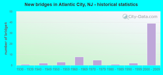
- New bridges - historical statistics
- 11930-1939
- 21940-1949
- 31950-1959
- 81960-1969
- 51970-1979
- 11980-1989
- 21990-1999
- 392000-2009


- Bridge Condition - Deck
- 9.1%Very good
- 57.6%Good
- 21.2%Satisfactory
- 9.1%Fair
- 3.0%Poor

- Bridge Condition - Superstructure
- 9.1%Very good
- 51.5%Good
- 15.2%Satisfactory
- 21.2%Fair
- 3.0%Poor

- Bridge Condition - Substructure
- 45.5%Good
- 33.3%Satisfactory
- 9.1%Fair
- 9.1%Poor
- 3.0%Serious

- Bridge Condition - Channel
- 15.4%Very good
- 76.9%Good
- 7.7%Satisfactory
Find on map >> Show street view
Structure Number: 10315, Location: 0.24 MI NW OF 30-87 JCT (Lat: 39.374789, Lng: -74.444161), Route carried "on" structure: US 30, Year Built: 2003, Status: Open, Structure Length: 3.14m (10.30ft), Average Daily Traffic: 62,654 (year 2020), Truck Traffic: 4%, Average Future Daily Traffic: 76,519 (year 2040), Design Load: HS 25 or greater, Features Intersected: PENROSE CANAL
Minimum Vertical Clearance: 30+ m (98+ ft), Kilometerpoint: 92.151, Lanes on structure: 6, Base Highway Network: Yes, Owner: State Highway Agency, Approaching Roadway Width: 28.3m (92.8ft), Skew: 30 degrees, Material/Design: Prestressed concrete, Design/Construction: Slab, Number Of Spans In Main Unit: 2, Length of Maximum Span: 14.6m (47.9ft), Curb or Sidewalk Widths: Left: 1.8m (5.9ft), Right: 1.8m (5.9ft), Curb-To-Curb Width: 28.0m (91.9ft), Out-to-Out Width: 33.1m (108.6ft)
Condition: Deck: Good, Superstructure: Very good, Substructure: Good, Channel: Good, Inventory Rating: 44.5 metric tons, Method Used To Determine Inventory Rating: Load Factor (LF), Structural Evaluation: Better than present minimum criteria, Deck Geometry: Superior to present desirable criteria, Waterway Adequacy: Equal to present minimum criteria, Approach Roadway Alignment: Equal to present desirable criteria, Designated Inspection Frequency: Every 24 months, Underwater Inspection Frequency: Every 24 months, Inspection Date: October 2020, Underwater Inspection Date: November 2020, Deck Structure Type: Concrete Cast-file-Place, Wearing Surface/Protective System: Wearing Surface: Monolithic Concrete, Deck Protection: Galvanized Reinforcing
Find on map >> Show street view
Structure Number: 103151, Location: 0.6MI W OF 30-87 JCT (Lat: 39.374939, Lng: -74.443939), Route carried "on" structure: US 30, Year Built: 1946, Year Reconstructed: 1994, Status: Open, Structure Length: 5.58m (18.31ft), Average Daily Traffic: 42,205 (year 2019), Truck Traffic: 4%, Average Future Daily Traffic: 50,646 (year 2039), Design Load: HS 20, Features Intersected: VENICE LAGOON
Minimum Vertical Clearance: 30+ m (98+ ft), Kilometerpoint: 91.523, Lanes on structure: 6, Base Highway Network: Yes, Owner: State Highway Agency, Approaching Roadway Width: 24.4m (80.1ft), Skew: 30 degrees, Material/Design: Concrete, Design/Construction: Slab, Number Of Spans In Main Unit: 9, Length of Maximum Span: 6.1m (20.0ft), Curb or Sidewalk Widths: Left: 1.4m (4.6ft), Right: 1.4m (4.6ft), Curb-To-Curb Width: 21.9m (71.9ft), Out-to-Out Width: 27.4m (89.9ft)
Condition: Deck: Satisfactory, Superstructure: Satisfactory, Substructure: Fair, Channel: Good, Operating Rating: 88.0 metric tons, Method Used To Determine Operating Rating: Load Factor (LF), Inventory Rating: 52.6 metric tons, Method Used To Determine Inventory Rating: Load Factor (LF), Structural Evaluation: Somewhat better than minimum adequacy, Deck Geometry: High priority of corrective action, Waterway Adequacy: Equal to present desirable criteria, Approach Roadway Alignment: Equal to present minimum criteria, Designated Inspection Frequency: Every 24 months, Underwater Inspection Frequency: Every 48 months, Inspection Date: April 2021, Underwater Inspection Date: June 2019, Deck Structure Type: Concrete Cast-file-Place, Wearing Surface/Protective System: Wearing Surface: Bituminous, Membrane: Preformed Fabric
Find on map >> Show street view
Structure Number: 103152, Location: 5.18 MI E of US 9 Int. (Lat: 39.377569, Lng: -74.453311), Route carried "on" structure: US 30, Year Built: 1946, Year Reconstructed: 1994, Status: Open, Structure Length: 14.48m (47.51ft), Average Daily Traffic: 42,624 (year 2020), Truck Traffic: 4%, Average Future Daily Traffic: 51,149 (year 2040), Design Load: HS 20, Features Intersected: Beach Thorofare
Minimum Vertical Clearance: 30+ m (98+ ft), Kilometerpoint: 91.346, Lanes on structure: 6, Base Highway Network: Yes, Owner: State Highway Agency, Approaching Roadway Width: 21.6m (70.9ft), Skew: 30 degrees, Navigation Control: Yes ( Vertical Clearance: 6.1m (20.0ft), Horizontal Clearance: 18.3m (60.0ft)), Material/Design: Steel, Design/Construction: Movable - Bascule, Number Of Spans In Main Unit: 1, Number Of Approach Spans: 6, Length of Maximum Span: 24.7m (81.0ft), Curb or Sidewalk Widths: Left: 1.5m (4.9ft), Right: 1.5m (4.9ft), Curb-To-Curb Width: 21.8m (71.5ft), Out-to-Out Width: 28.5m (93.5ft)
Condition: Deck: Fair, Superstructure: Fair, Substructure: Fair, Channel: Good, Operating Rating: 29.9 metric tons, Method Used To Determine Operating Rating: Load Factor (LF), Inventory Rating: 18.1 metric tons, Method Used To Determine Inventory Rating: Load Factor (LF), Structural Evaluation: Meets minimum limits, Deck Geometry: High priority of replacement, Waterway Adequacy: Equal to present desirable criteria, Approach Roadway Alignment: Equal to present desirable criteria, Length Of Structure Improvement: 60.96m (200.00ft), Designated Inspection Frequency: Every 24 months, Critical Feature Inspection Frequency: Every 24 months, Underwater Inspection Frequency: Every 48 months, Inspection Date: May 2020, Critical Feature Inspection Date: May 2020, Underwater Inspection Date: May 2018, Bridge Improvement Cost: $86,400,000, Roadway Improvement Cost: $8,640,000, Total Project Cost: $129,950,000 ( Estimate for 2020), Deck Structure Type: Concrete Cast-file-Place, Wearing Surface/Protective System: Wearing Surface: Latex Concrete
Find on map >> Show street view
Structure Number: 103153, Location: 1.25 MI NW OF 30-87 JCT (Lat: 39.382469, Lng: -74.459461), Route carried "on" structure: US 30, Year Built: 1952, Year Reconstructed: 1994, Status: Open, Structure Length: 9.24m (30.31ft), Average Daily Traffic: 44,392 (year 2021), Truck Traffic: 7%, Average Future Daily Traffic: 54,166 (year 2041), Design Load: HS 20, Features Intersected: DUCK THOROFARE
Minimum Vertical Clearance: 30+ m (98+ ft), Kilometerpoint: 90.477, Lanes on structure: 4, Base Highway Network: Yes, Owner: State Highway Agency, Approaching Roadway Width: 22.6m (74.1ft), Skew: 30 degrees, Material/Design: Concrete continuous, Design/Construction: Slab, Number Of Spans In Main Unit: 25, Length of Maximum Span: 3.7m (12.1ft), Curb or Sidewalk Widths: Left: 1.1m (3.6ft), Right: 1.1m (3.6ft), Curb-To-Curb Width: 21.9m (71.9ft), Out-to-Out Width: 26.5m (86.9ft)
Condition: Deck: Poor, Superstructure: Poor, Substructure: Fair, Channel: Good, Operating Rating: 30.8 metric tons, Method Used To Determine Operating Rating: Load Factor (LF), Inventory Rating: 18.1 metric tons, Method Used To Determine Inventory Rating: Load Factor (LF), Structural Evaluation: Meets minimum limits, Deck Geometry: Superior to present desirable criteria, Waterway Adequacy: Equal to present minimum criteria, Approach Roadway Alignment: Equal to present desirable criteria, Length Of Structure Improvement: 9.24m (30.31ft), Designated Inspection Frequency: Every 24 months, Underwater Inspection Frequency: Every 24 months, Inspection Date: April 2021, Underwater Inspection Date: April 2021, Bridge Improvement Cost: $8,671,000, Roadway Improvement Cost: $867,000, Total Project Cost: $13,526,000 ( Estimate for 2021), Deck Structure Type: Concrete Cast-file-Place, Wearing Surface/Protective System: Wearing Surface: Latex Concrete
Find on map >> Show street view
Structure Number: 103154, Location: 0.9 MI W OF BEACH THORO (Lat: 39.386139, Lng: -74.465500), Route carried "on" structure: US 30, Year Built: 1952, Year Reconstructed: 1994, Status: Open, Structure Length: 7.77m (25.49ft), Average Daily Traffic: 53,245 (year 2021), Truck Traffic: 7%, Average Future Daily Traffic: 63,900 (year 2041), Design Load: HS 20, Features Intersected: NEWFOUND THOROFARE
Minimum Vertical Clearance: 30+ m (98+ ft), Kilometerpoint: 89.801, Lanes on structure: 4, Base Highway Network: Yes, Owner: State Highway Agency, Approaching Roadway Width: 22.6m (74.1ft), Skew: 30 degrees, Material/Design: Concrete continuous, Design/Construction: Slab, Number Of Spans In Main Unit: 21, Length of Maximum Span: 3.7m (12.1ft), Curb or Sidewalk Widths: Left: 1.1m (3.6ft), Right: 1.2m (3.9ft), Curb-To-Curb Width: 21.8m (71.5ft), Out-to-Out Width: 26.5m (86.9ft)
Condition: Deck: Fair, Superstructure: Fair, Substructure: Poor, Channel: Good, Operating Rating: 30.8 metric tons, Method Used To Determine Operating Rating: Load Factor (LF), Inventory Rating: 18.1 metric tons, Method Used To Determine Inventory Rating: Load Factor (LF), Structural Evaluation: Meets minimum limits, Deck Geometry: Superior to present desirable criteria, Waterway Adequacy: Equal to present minimum criteria, Approach Roadway Alignment: Equal to present desirable criteria, Length Of Structure Improvement: 8.84m (29.00ft), Designated Inspection Frequency: Every 24 months, Underwater Inspection Frequency: Every 24 months, Inspection Date: April 2021, Underwater Inspection Date: April 2021, Bridge Improvement Cost: $13,000, Roadway Improvement Cost: $171,000, Total Project Cost: $20,000 ( Estimate for 2021), Deck Structure Type: Concrete Cast-file-Place, Wearing Surface/Protective System: Wearing Surface: Latex Concrete
Find on map >> Show street view
Structure Number: 103155, Location: 0.35 MI SE OF30 DELILAHRD (Lat: 39.391900, Lng: -74.489231), Route carried "on" structure: US 30, Year Built: 1952, Year Reconstructed: 1994, Status: Open, Structure Length: 1.40m (4.59ft), Average Daily Traffic: 51,400 (year 2021), Truck Traffic: 4%, Average Future Daily Traffic: 61,680 (year 2041), Features Intersected: JONATHAN'S THOROFARE
Minimum Vertical Clearance: 30+ m (98+ ft), Kilometerpoint: 87.613, Lanes on structure: 4, Base Highway Network: Yes, Owner: State Highway Agency, Approaching Roadway Width: 21.9m (71.9ft), Skew: 31 degrees, Material/Design: Concrete continuous, Design/Construction: Slab, Number Of Spans In Main Unit: 4, Length of Maximum Span: 3.4m (11.2ft), Curb or Sidewalk Widths: Left: 1.1m (3.6ft), Right: 1.1m (3.6ft), Curb-To-Curb Width: 21.8m (71.5ft), Out-to-Out Width: 26.5m (86.9ft)
Condition: Deck: Satisfactory, Superstructure: Satisfactory, Substructure: Poor, Channel: Good, Operating Rating: 39.0 metric tons, Method Used To Determine Operating Rating: Load Factor (LF), Inventory Rating: 27.2 metric tons, Method Used To Determine Inventory Rating: Load Factor (LF), Structural Evaluation: Meets minimum limits, Deck Geometry: Superior to present desirable criteria, Waterway Adequacy: Equal to present minimum criteria, Approach Roadway Alignment: Equal to present desirable criteria, Length Of Structure Improvement: 1.40m (4.59ft), Designated Inspection Frequency: Every 24 months, Underwater Inspection Frequency: Every 48 months, Inspection Date: April 2021, Underwater Inspection Date: June 2021, Bridge Improvement Cost: $3,122,000, Roadway Improvement Cost: $343,000, Total Project Cost: $4,800,000 ( Estimate for 2019), Deck Structure Type: Concrete Cast-file-Place, Wearing Surface/Protective System: Wearing Surface: Bituminous, Membrane: Preformed Fabric
Find on map >> Show street view
Structure Number: 109153, Location: 3.3 MI EAST OF US 9 JCT (Lat: 39.370231, Lng: -74.476850), Route carried "on" structure: US 40, Year Built: 1989, Status: Open, Structure Length: 9.33m (30.61ft), Average Daily Traffic: 28,299 (year 2019), Truck Traffic: 4%, Average Future Daily Traffic: 33,959 (year 2039), Design Load: HS 20+Mod, Features Intersected: GREAT THOROFARE
Minimum Vertical Clearance: 30+ m (98+ ft), Kilometerpoint: 100.520, Lanes on structure: 4, Base Highway Network: Yes, Owner: State Highway Agency, Approaching Roadway Width: 24.1m (79.1ft), Skew: 30 degrees, Material/Design: Prestressed concrete continuous, Design/Construction: Box Beam or Girders - Multiple, Number Of Spans In Main Unit: 9, Length of Maximum Span: 11.0m (36.1ft), Curb or Sidewalk Widths: Left: 0.0m, Right: 3.0m (9.8ft), Curb-To-Curb Width: 24.2m (79.4ft), Out-to-Out Width: 29.0m (95.1ft)
Condition: Deck: Good, Superstructure: Good, Substructure: Satisfactory, Channel: Good, Operating Rating: 89.8 metric tons, Method Used To Determine Operating Rating: Load Factor (LF), Inventory Rating: 49.0 metric tons, Method Used To Determine Inventory Rating: Load Factor (LF), Structural Evaluation: Equal to present minimum criteria, Deck Geometry: Superior to present desirable criteria, Waterway Adequacy: Equal to present minimum criteria, Approach Roadway Alignment: Equal to present desirable criteria, Designated Inspection Frequency: Every 24 months, Underwater Inspection Frequency: Every 48 months, Inspection Date: April 2021, Underwater Inspection Date: September 2021, Deck Structure Type: Concrete Cast-file-Place, Wearing Surface/Protective System: Wearing Surface: Monolithic Concrete, Deck Protection: Epoxy Coated Reinforcing
Find on map >> Show street view
Structure Number: 109154, Location: WEST OF BADER FIELD AIRPT (Lat: 39.361350, Lng: -74.464789), Route carried "on" structure: US 40, Year Built: 1990, Status: Open, Structure Length: 11.19m (36.71ft), Average Daily Traffic: 29,462 (year 2021), Truck Traffic: 4%, Average Future Daily Traffic: 35,355 (year 2041), Design Load: HS 20+Mod, Features Intersected: BEACH THOROFARE
Minimum Vertical Clearance: 30+ m (98+ ft), Kilometerpoint: 101.968, Lanes on structure: 4, Base Highway Network: Yes, Owner: State Highway Agency, Approaching Roadway Width: 24.1m (79.1ft), Skew: 30 degrees, Material/Design: Prestressed concrete, Design/Construction: Box Beam or Girders - Multiple, Number Of Spans In Main Unit: 10, Length of Maximum Span: 11.0m (36.1ft), Curb or Sidewalk Widths: Left: 0.0m, Right: 2.4m (7.9ft), Curb-To-Curb Width: 24.3m (79.7ft), Out-to-Out Width: 29.0m (95.1ft)
Condition: Deck: Good, Superstructure: Good, Substructure: Satisfactory, Channel: Good, Inventory Rating: 72.6 metric tons, Method Used To Determine Inventory Rating: Load Factor (LF), Structural Evaluation: Equal to present minimum criteria, Deck Geometry: Superior to present desirable criteria, Waterway Adequacy: Equal to present desirable criteria, Approach Roadway Alignment: Better than present minimum criteria, Designated Inspection Frequency: Every 24 months, Underwater Inspection Frequency: Every 48 months, Inspection Date: April 2021, Underwater Inspection Date: October 2019, Deck Structure Type: Concrete Cast-file-Place, Wearing Surface/Protective System: Wearing Surface: Monolithic Concrete, Deck Protection: Epoxy Coated Reinforcing
Find on map >> Show street view
Structure Number: 109155, Location: 4.87M SE of US9&ACEXP JCT (Lat: 39.354111, Lng: -74.457281), Route carried "on" structure: US 40, Year Built: 1991, Status: Open, Structure Length: 13.17m (43.21ft), Average Daily Traffic: 28,879 (year 2020), Truck Traffic: 4%, Average Future Daily Traffic: 35,238 (year 2040), Design Load: HS 20+Mod, Features Intersected: INSIDE THOROFARE
Minimum Vertical Clearance: 30+ m (98+ ft), Kilometerpoint: 103.046, Lanes on structure: 4, Base Highway Network: Yes, Owner: State Highway Agency, Approaching Roadway Width: 21.9m (71.9ft), Navigation Control: Yes ( Vertical Clearance: 3.0m (9.8ft), Horizontal Clearance: 15.2m (49.9ft)), Material/Design: Steel, Design/Construction: Movable - Bascule, Number Of Spans In Main Unit: 1, Number Of Approach Spans: 9, Length of Maximum Span: 25.9m (85.0ft), Curb or Sidewalk Widths: Left: 3.0m (9.8ft), Right: 3.0m (9.8ft), Curb-To-Curb Width: 21.9m (71.9ft), Out-to-Out Width: 28.7m (94.2ft)
Condition: Deck: Good, Superstructure: Satisfactory, Substructure: Satisfactory, Channel: Good, Operating Rating: 64.4 metric tons, Method Used To Determine Operating Rating: Load Factor (LF), Inventory Rating: 39.0 metric tons, Method Used To Determine Inventory Rating: Load Factor (LF), Structural Evaluation: Equal to present minimum criteria, Deck Geometry: Superior to present desirable criteria, Waterway Adequacy: Equal to present desirable criteria, Approach Roadway Alignment: Better than present minimum criteria, Designated Inspection Frequency: Every 24 months, Critical Feature Inspection Frequency: Every 24 months, Underwater Inspection Frequency: Every 48 months, Inspection Date: April 2020, Critical Feature Inspection Date: April 2020, Underwater Inspection Date: June 2020, Deck Structure Type: Concrete Cast-file-Place, Wearing Surface/Protective System: Wearing Surface: Latex Concrete, Deck Protection: Epoxy Coated Reinforcing
Find on map >> Show street view
Structure Number: 109156, Location: 3.1 MILES EAST OF US 9 (Lat: 39.367561, Lng: -74.473419), Route carried "on" structure: City street , Year Built: 1970, Status: Open, Structure Length: 4.02m (13.19ft), Average Daily Traffic: 2,405 (year 2021), Truck Traffic: 1%, Average Future Daily Traffic: 2,885 (year 2041), Design Load: HS 20, Features Intersected: US 40 & 322, Facility Carried by Structure: DORSET AVENUE CONN
Minimum Vertical Clearance: 30+ m (98+ ft), Kilometerpoint: 0.000, Lanes on structure: 2, Lanes under structure: 6, Owner: State Highway Agency, Approaching Roadway Width: 13.4m (44.0ft), Skew: 21 degrees, Material/Design: Steel, Design/Construction: Stringer/Multi-beam, Number Of Spans In Main Unit: 1, Length of Maximum Span: 39.6m (129.9ft), Curb or Sidewalk Widths: Left: 0.5m (1.6ft), Right: 1.8m (5.9ft), Curb-To-Curb Width: 13.4m (44.0ft), Out-to-Out Width: 18.1m (59.4ft)
Condition: Deck: Satisfactory, Superstructure: Fair, Substructure: Satisfactory, Inventory Rating: 60.8 metric tons, Method Used To Determine Inventory Rating: Load Factor (LF), Structural Evaluation: Somewhat better than minimum adequacy, Deck Geometry: Better than present minimum criteria, Underclear: Equal to present minimum criteria, Approach Roadway Alignment: Equal to present minimum criteria, Designated Inspection Frequency: Every 24 months, Inspection Date: April 2021, Deck Structure Type: Concrete Cast-file-Place, Wearing Surface/Protective System: Wearing Surface: Monolithic Concrete
Find on map >> Show street view
Structure Number: 11515, Location: 1.07 MILE NORTH OF US 30 (Lat: 39.383500, Lng: -74.424900), Route carried "on" structure: State highway 87, Year Built: 1972, Status: Open, Structure Length: 65.47m (214.80ft), Average Daily Traffic: 21,285 (year 2021), Truck Traffic: 4%, Average Future Daily Traffic: 25,542 (year 2041), Design Load: HS 20, Features Intersected: ABSEC. INL.&RAMPJ&N.VE
Minimum Vertical Clearance: 30+ m (98+ ft), Kilometerpoint: 1.722, Lanes on structure: 4, Lanes under structure: 4, Base Highway Network: Yes, Owner: State Highway Agency, Approaching Roadway Width: 16.5m (54.1ft), Skew: 30 degrees, Navigation Control: Yes ( Vertical Clearance: 18.3m (60.0ft), Horizontal Clearance: 34.1m (111.9ft)), Material/Design: Steel continuous, Design/Construction: Stringer/Multi-beam, Number Of Spans In Main Unit: 9, Number Of Approach Spans: 2, Length of Maximum Span: 60.7m (199.1ft), Curb or Sidewalk Widths: Left: 0.5m (1.6ft), Right: 1.8m (5.9ft), Curb-To-Curb Width: 16.5m (54.1ft), Out-to-Out Width: 20.0m (65.6ft)
Condition: Deck: Fair, Superstructure: Fair, Substructure: Satisfactory, Channel: Very good, Operating Rating: 68.0 metric tons, Method Used To Determine Operating Rating: Load Factor (LF), Inventory Rating: 40.8 metric tons, Method Used To Determine Inventory Rating: Load Factor (LF), Structural Evaluation: Somewhat better than minimum adequacy, Deck Geometry: Meets minimum limits, Underclear: Meets minimum limits, Waterway Adequacy: Superior to present desirable criteria, Approach Roadway Alignment: Equal to present desirable criteria, Length Of Structure Improvement: 6.10m (20.01ft), Designated Inspection Frequency: Every 24 months, Critical Feature Inspection Frequency: Every 24 months, Underwater Inspection Frequency: Every 24 months, Inspection Date: July 2021, Critical Feature Inspection Date: July 2021, Underwater Inspection Date: July 2021, Bridge Improvement Cost: $720,000, Total Project Cost: $792,000 ( Estimate for 2021), Deck Structure Type: Concrete Cast-file-Place, Wearing Surface/Protective System: Wearing Surface: Bituminous
Find on map >> Show street view
Structure Number: 1ATL01, Location: 80 FT EAST OF MURRAY AVE (Lat: 39.375561, Lng: -74.451189), Route carried "on" structure: City street , Year Built: 1969, Status: Posted for load, Structure Length: 3.96m (12.99ft), Average Daily Traffic: 1,622 (year 2021), Truck Traffic: 3%, Average Future Daily Traffic: 1,947 (year 2041), Features Intersected: VENICE LAGOON, Facility Carried by Structure: OHIO AVENUE
Minimum Vertical Clearance: 0.00m, Kilometerpoint: 0.000, Lanes on structure: 2, Owner: City or Municipal Highway Agency, Approaching Roadway Width: 11.9m (39.0ft), Material/Design: Steel, Design/Construction: Stringer/Multi-beam, Number Of Spans In Main Unit: 7, Length of Maximum Span: 6.4m (21.0ft), Curb or Sidewalk Widths: Left: 1.2m (3.9ft), Right: 1.2m (3.9ft), Curb-To-Curb Width: 9.2m (30.2ft), Out-to-Out Width: 12.2m (40.0ft)
Condition: Deck: Satisfactory, Superstructure: Fair, Substructure: Serious, Channel: Good, Operating Rating: 39.9 metric tons, Method Used To Determine Operating Rating: Allowable Stress (AS), Inventory Rating: 27.2 metric tons, Method Used To Determine Inventory Rating: Allowable Stress (AS), Structural Evaluation: High priority of corrective action, Deck Geometry: Somewhat better than minimum adequacy, Waterway Adequacy: Equal to present desirable criteria, Approach Roadway Alignment: Better than present minimum criteria, Length Of Structure Improvement: 3.96m (12.99ft), Designated Inspection Frequency: Every 24 months, Underwater Inspection Frequency: Every 12 months, Other Special Inspection Frequency: Every 6 months, Inspection Date: January 2021, Underwater Inspection Date: March 2021, Other Special Inspection Date: January 2022, Bridge Improvement Cost: $4,366,000, Roadway Improvement Cost: $133,000, Total Project Cost: $5,850,000 ( Estimate for 2021), Deck Structure Type: Concrete Cast-file-Place, Wearing Surface/Protective System: Wearing Surface: Bituminous
Find on map >> Show street view
Structure Number: 1ATL02, Location: 100 FT E OF E RIVERSID DR (Lat: 39.373639, Lng: -74.444539), Route carried "on" structure: City street , Year Built: 1969, Status: Posted for load, Structure Length: 2.44m (8.01ft), Average Daily Traffic: 1,467 (year 2021), Truck Traffic: 4%, Average Future Daily Traffic: 1,760 (year 2041), Features Intersected: PENROSE CANAL, Facility Carried by Structure: OHIO AVENUE
Minimum Vertical Clearance: 0.00m, Kilometerpoint: 0.000, Lanes on structure: 2, Owner: City or Municipal Highway Agency, Approaching Roadway Width: 12.2m (40.0ft), Material/Design: Steel, Design/Construction: Stringer/Multi-beam, Number Of Spans In Main Unit: 5, Length of Maximum Span: 6.1m (20.0ft), Curb or Sidewalk Widths: Left: 1.2m (3.9ft), Right: 1.2m (3.9ft), Curb-To-Curb Width: 9.1m (29.9ft), Out-to-Out Width: 12.2m (40.0ft)
Condition: Deck: Satisfactory, Superstructure: Fair, Substructure: Poor, Channel: Very good, Operating Rating: 25.4 metric tons, Method Used To Determine Operating Rating: Allowable Stress (AS), Inventory Rating: 15.4 metric tons, Method Used To Determine Inventory Rating: Allowable Stress (AS), Structural Evaluation: Meets minimum limits, Deck Geometry: Somewhat better than minimum adequacy, Waterway Adequacy: Equal to present desirable criteria, Approach Roadway Alignment: Better than present minimum criteria, Bridge Posting: Required (Relationship of Operating Rating to Maximum Legal Load: 0.1 - 9.9% below), Length Of Structure Improvement: 2.44m (8.01ft), Designated Inspection Frequency: Every 24 months, Underwater Inspection Frequency: Every 48 months, Other Special Inspection Frequency: Every 12 months, Inspection Date: January 2021, Underwater Inspection Date: April 2021, Other Special Inspection Date: January 2021, Bridge Improvement Cost: $2,686,000, Roadway Improvement Cost: $133,000, Total Project Cost: $3,665,000 ( Estimate for 2021), Deck Structure Type: Concrete Cast-file-Place, Wearing Surface/Protective System: Wearing Surface: Bituminous
Find on map >> Show street view
Structure Number: 1510151, Location: 0.27 MI W OF CO. 571 JCT (Lat: 40.021219, Lng: -74.273711), Route carried "on" structure: State highway 70, Year Built: 1936, Status: Open, Structure Length: 1.04m (3.41ft), Average Daily Traffic: 26,145 (year 2021), Truck Traffic: 4%, Average Future Daily Traffic: 31,375 (year 2041), Features Intersected: RIDGEWAY BRANCH
Minimum Vertical Clearance: 30+ m (98+ ft), Kilometerpoint: 75.028, Lanes on structure: 2, Base Highway Network: Yes, Owner: State Highway Agency, Approaching Roadway Width: 12.2m (40.0ft), Material/Design: Steel, Design/Construction: Stringer/Multi-beam, Number Of Spans In Main Unit: 1, Length of Maximum Span: 9.8m (32.2ft), Curb-To-Curb Width: 12.2m (40.0ft), Out-to-Out Width: 13.5m (44.3ft)
Condition: Deck: Satisfactory, Superstructure: Good, Substructure: Satisfactory, Channel: Satisfactory, Inventory Rating: 70.8 metric tons, Method Used To Determine Inventory Rating: Load Factor (LF), Structural Evaluation: Equal to present minimum criteria, Deck Geometry: Somewhat better than minimum adequacy, Waterway Adequacy: Superior to present desirable criteria, Approach Roadway Alignment: Equal to present desirable criteria, Designated Inspection Frequency: Every 24 months, Underwater Inspection Frequency: Every 48 months, Inspection Date: April 2021, Underwater Inspection Date: April 2021, Deck Structure Type: Concrete Cast-file-Place, Wearing Surface/Protective System: Wearing Surface: Bituminous
Find on map >> Show street view
Structure Number: 35002, Location: 0.1 MI E OF BEACH THOROFA (Lat: 39.373331, Lng: -74.438331), Route carried "on" structure: Other road ACE, Year Built: 1963, Status: Open, Structure Length: 0.79m (2.59ft), Average Daily Traffic: 79,380 (year 2012), Truck Traffic: 5%, Average Future Daily Traffic: 110,805 (year 2032), Design Load: HS 20, Features Intersected: ABANDONED RAILROAD, Facility Carried by Structure: A.C. EXPRESSWAY
Minimum Vertical Clearance: 30+ m (98+ ft), Kilometerpoint: 0.322, Lanes on structure: 6, Base Highway Network: Yes, Toll: On toll road, Owner: State Toll Authority, Maintenance Responsibility: Private, Approaching Roadway Width: 13.1m (43.0ft), Skew: 5 degrees, Material/Design: Concrete, Design/Construction: Slab, Number Of Spans In Main Unit: 1, Length of Maximum Span: 6.7m (22.0ft), Curb-To-Curb Width: 23.0m (75.5ft), Out-to-Out Width: 24.7m (81.0ft)
Condition: Deck: Good, Superstructure: Satisfactory, Substructure: Satisfactory, Operating Rating: 46.3 metric tons, Method Used To Determine Operating Rating: Load Factor (LF), Inventory Rating: 28.1 metric tons, Method Used To Determine Inventory Rating: Load Factor (LF), Structural Evaluation: Equal to present minimum criteria, Deck Geometry: High priority of replacement, Approach Roadway Alignment: Better than present minimum criteria, Designated Inspection Frequency: Every 24 months, Inspection Date: April 2020, Deck Structure Type: Concrete Cast-file-Place, Wearing Surface/Protective System: Wearing Surface: Bituminous
Find on map >> Show street view
Structure Number: 350023A, Location: AT INTERCHANGE 2 (ACE) (Lat: 39.376669, Lng: -74.480000), Route carried "on" structure: Ramp Other road ACE, Year Built: 1965, Status: Open, Structure Length: 4.88m (16.01ft), Average Daily Traffic: 7,960 (year 2010), Truck Traffic: 5%, Average Future Daily Traffic: 11,250 (year 2030), Design Load: H 20, Features Intersected: ATLANTIC CITY EXPRESSWAY, Facility Carried by Structure: RAMP F
Minimum Vertical Clearance: 30+ m (98+ ft), Kilometerpoint: 3.701, Lanes on structure: 1, Lanes under structure: 6, Toll: On toll road, Owner: State Toll Authority, Maintenance Responsibility: Private, Approaching Roadway Width: 8.2m (26.9ft), Material/Design: Prestressed concrete, Design/Construction: Stringer/Multi-beam, Number Of Spans In Main Unit: 4, Length of Maximum Span: 17.1m (56.1ft), Curb or Sidewalk Widths: Left: 0.5m (1.6ft), Right: 0.5m (1.6ft), Curb-To-Curb Width: 6.7m (22.0ft), Out-to-Out Width: 8.5m (27.9ft)
Condition: Deck: Good, Superstructure: Satisfactory, Substructure: Satisfactory, Operating Rating: 89.8 metric tons, Method Used To Determine Operating Rating: Load Factor (LF), Inventory Rating: 62.6 metric tons, Method Used To Determine Inventory Rating: Load Factor (LF), Structural Evaluation: Equal to present minimum criteria, Deck Geometry: Equal to present minimum criteria, Underclear: Somewhat better than minimum adequacy, Approach Roadway Alignment: Equal to present minimum criteria, Length Of Structure Improvement: 4.90m (16.08ft), Designated Inspection Frequency: Every 24 months, Inspection Date: April 2020, Deck Structure Type: Concrete Cast-file-Place, Wearing Surface/Protective System: Wearing Surface: Monolithic Concrete
Find on map >> Show street view
Structure Number: 350024D, Location: 2.5 MI W OF RT30&87 JCT (Lat: 39.368331, Lng: -74.465000), Route carried "on" structure: Ramp Other road ACE, Year Built: 1965, Status: Open, Structure Length: 5.12m (16.80ft), Average Daily Traffic: 12,370 (year 2010), Truck Traffic: 5%, Average Future Daily Traffic: 13,840 (year 2030), Design Load: H 20, Features Intersected: ALBANY AVE (RT 322 & 40), Facility Carried by Structure: AC EXP EB RAMP E
Minimum Vertical Clearance: 30+ m (98+ ft), Kilometerpoint: 3.959, Lanes on structure: 1, Lanes under structure: 4, Toll: On toll road, Owner: State Toll Authority, Maintenance Responsibility: Private, Approaching Roadway Width: 11.0m (36.1ft), Skew: 2 degrees, Material/Design: Steel, Design/Construction: Stringer/Multi-beam, Number Of Spans In Main Unit: 3, Length of Maximum Span: 34.7m (113.8ft), Curb or Sidewalk Widths: Left: 0.5m (1.6ft), Right: 0.5m (1.6ft), Curb-To-Curb Width: 7.0m (23.0ft), Out-to-Out Width: 8.5m (27.9ft)
Condition: Deck: Good, Superstructure: Fair, Substructure: Satisfactory, Operating Rating: 74.4 metric tons, Method Used To Determine Operating Rating: Load Factor (LF), Inventory Rating: 44.5 metric tons, Method Used To Determine Inventory Rating: Load Factor (LF), Structural Evaluation: Somewhat better than minimum adequacy, Deck Geometry: Equal to present minimum criteria, Underclear: Equal to present minimum criteria, Approach Roadway Alignment: Equal to present minimum criteria, Designated Inspection Frequency: Every 24 months, Inspection Date: April 2020, Deck Structure Type: Concrete Cast-file-Place, Wearing Surface/Protective System: Wearing Surface: Bituminous
Find on map >> Show street view
Structure Number: 3500C02, Location: ATLANTIC CITY (Lat: 39.362778, Lng: -74.441389), Route carried "on" structure: Ramp Other road 466X, Year Built: 2001, Status: Open, Structure Length: 12.74m (41.80ft), Average Daily Traffic: 21,420 (year 2012), Truck Traffic: 5%, Average Future Daily Traffic: 25,690 (year 2032), Design Load: HS 25 or greater, Features Intersected: A C EXPRESSWAY, Facility Carried by Structure: AC/BC RAMP A1
Minimum Vertical Clearance: 30+ m (98+ ft), Kilometerpoint: 0.145, Lanes on structure: 2, Lanes under structure: 5, Owner: State Toll Authority, Maintenance Responsibility: Private, Approaching Roadway Width: 9.4m (30.8ft), Skew: 9 degrees, Material/Design: Steel continuous, Design/Construction: Stringer/Multi-beam, Number Of Spans In Main Unit: 3, Length of Maximum Span: 50.6m (166.0ft), Curb-To-Curb Width: 9.8m (32.2ft), Out-to-Out Width: 12.6m (41.3ft)
Condition: Deck: Good, Superstructure: Good, Substructure: Good, Operating Rating: 84.5 metric tons, Method Used To Determine Operating Rating: Load Factor (LF), Inventory Rating: 50.7 metric tons, Method Used To Determine Inventory Rating: Load Factor (LF), Structural Evaluation: Better than present minimum criteria, Deck Geometry: Equal to present minimum criteria, Underclear: Meets minimum limits, Approach Roadway Alignment: Equal to present minimum criteria, Designated Inspection Frequency: Every 24 months, Inspection Date: April 2020, Deck Structure Type: Concrete Cast-file-Place
Find on map >> Show street view
Structure Number: 3500C04, Location: ATLANTIC CITY (Lat: 39.361944, Lng: -74.442222), Route carried "on" structure: Ramp Other road 446X, Year Built: 2001, Status: Open, Structure Length: 3.78m (12.40ft), Average Daily Traffic: 21,420 (year 2012), Truck Traffic: 5%, Average Future Daily Traffic: 25,690 (year 2032), Design Load: HS 25 or greater, Features Intersected: AC/BC RAMP A2 & A3, Facility Carried by Structure: AC/BC RAMP A1
Minimum Vertical Clearance: 30+ m (98+ ft), Kilometerpoint: 0.306, Lanes on structure: 2, Lanes under structure: 5, Owner: State Toll Authority, Maintenance Responsibility: Private, Approaching Roadway Width: 9.4m (30.8ft), Skew: 9 degrees, Material/Design: Prestressed concrete, Design/Construction: Stringer/Multi-beam, Number Of Spans In Main Unit: 1, Length of Maximum Span: 37.8m (124.0ft), Curb-To-Curb Width: 9.7m (31.8ft), Out-to-Out Width: 10.8m (35.4ft)
Condition: Deck: Good, Superstructure: Good, Substructure: Good, Operating Rating: 72.2 metric tons, Method Used To Determine Operating Rating: Load Factor (LF), Inventory Rating: 43.3 metric tons, Method Used To Determine Inventory Rating: Load Factor (LF), Structural Evaluation: Better than present minimum criteria, Deck Geometry: Somewhat better than minimum adequacy, Underclear: Somewhat better than minimum adequacy, Approach Roadway Alignment: Somewhat better than minimum adequacy, Designated Inspection Frequency: Every 24 months, Inspection Date: April 2020, Deck Structure Type: Concrete Cast-file-Place
Find on map >> Show street view
Structure Number: 3500C05, Location: ATLANTIC CITY (Lat: 39.365556, Lng: -74.444167), Route carried "on" structure: Ramp Other road 446X, Year Built: 2001, Status: Open, Structure Length: 2.47m (8.10ft), Average Daily Traffic: 21,425 (year 2012), Truck Traffic: 5%, Average Future Daily Traffic: 25,690 (year 2032), Design Load: HS 25 or greater, Features Intersected: AC/BC NOR & SOU BOUND, Facility Carried by Structure: BACHARCH BLVD.
Minimum Vertical Clearance: 30+ m (98+ ft), Kilometerpoint: 0.869, Lanes on structure: 2, Lanes under structure: 4, Owner: State Toll Authority, Maintenance Responsibility: Private, Approaching Roadway Width: 10.4m (34.1ft), Skew: 9 degrees, Material/Design: Prestressed concrete, Design/Construction: Stringer/Multi-beam, Number Of Spans In Main Unit: 1, Length of Maximum Span: 24.7m (81.0ft), Curb-To-Curb Width: 12.4m (40.7ft), Out-to-Out Width: 13.8m (45.3ft)
Condition: Deck: Good, Superstructure: Good, Substructure: Good, Operating Rating: 66.6 metric tons, Method Used To Determine Operating Rating: Load Factor (LF), Inventory Rating: 39.8 metric tons, Method Used To Determine Inventory Rating: Load Factor (LF), Structural Evaluation: Better than present minimum criteria, Deck Geometry: Superior to present desirable criteria, Underclear: High priority of corrective action, Approach Roadway Alignment: Equal to present minimum criteria, Designated Inspection Frequency: Every 24 months, Inspection Date: April 2020, Deck Structure Type: Concrete Cast-file-Place
Find on map >> Show street view
Structure Number: 3500C06, Location: ATLANTIC CITY (Lat: 39.365556, Lng: -74.444444), Route carried "on" structure: Ramp Other road 446x, Year Built: 2001, Status: Open, Structure Length: 20.24m (66.40ft), Average Daily Traffic: 580 (year 2012), Truck Traffic: 5%, Average Future Daily Traffic: 700 (year 2032), Design Load: HS 25 or greater, Features Intersected: BACHARCH BLVD., Facility Carried by Structure: AC/BC RAMP C2 & C4
Minimum Vertical Clearance: 30+ m (98+ ft), Kilometerpoint: 0.885, Lanes on structure: 1, Owner: State Toll Authority, Maintenance Responsibility: Private, Approaching Roadway Width: 16.2m (53.1ft), Skew: 9 degrees, Material/Design: Prestressed concrete continuous, Design/Construction: Stringer/Multi-beam, Number Of Spans In Main Unit: 7, Length of Maximum Span: 31.7m (104.0ft), Curb-To-Curb Width: 6.6m (21.7ft), Out-to-Out Width: 7.7m (25.3ft)
Condition: Deck: Good, Superstructure: Good, Substructure: Good, Operating Rating: 90.4 metric tons, Method Used To Determine Operating Rating: Load Factor (LF), Inventory Rating: 54.2 metric tons, Method Used To Determine Inventory Rating: Load Factor (LF), Structural Evaluation: Better than present minimum criteria, Deck Geometry: Somewhat better than minimum adequacy, Approach Roadway Alignment: Equal to present minimum criteria, Designated Inspection Frequency: Every 24 months, Inspection Date: April 2020, Deck Structure Type: Concrete Cast-file-Place
Find on map >> Show street view
Structure Number: 3500C13, Location: ATLANTIC CITY (Lat: 39.373611, Lng: -74.339719), Route carried "on" structure: Ramp Other road , Year Built: 2001, Status: Open, Structure Length: 10.21m (33.50ft), Average Daily Traffic: 21,420 (year 2012), Truck Traffic: 5%, Average Future Daily Traffic: 25,690 (year 2032), Design Load: HS 25 or greater, Features Intersected: RT. 30 WB AND RT. 87, Facility Carried by Structure: AC/BC RAMP RC3
Minimum Vertical Clearance: 30+ m (98+ ft), Kilometerpoint: 2.253, Lanes on structure: 2, Lanes under structure: 7, Owner: State Toll Authority, Maintenance Responsibility: Private, Approaching Roadway Width: 8.8m (28.9ft), Skew: 9 degrees, Material/Design: Steel continuous, Design/Construction: Stringer/Multi-beam, Number Of Spans In Main Unit: 2, Length of Maximum Span: 52.4m (171.9ft), Curb-To-Curb Width: 9.0m (29.5ft), Out-to-Out Width: 10.1m (33.1ft)
Condition: Deck: Good, Superstructure: Good, Substructure: Good, Operating Rating: 54.2 metric tons, Method Used To Determine Operating Rating: Load Factor (LF), Inventory Rating: 32.5 metric tons, Method Used To Determine Inventory Rating: Load Factor (LF), Structural Evaluation: Better than present minimum criteria, Deck Geometry: Meets minimum limits, Underclear: Somewhat better than minimum adequacy, Approach Roadway Alignment: Equal to present minimum criteria, Designated Inspection Frequency: Every 24 months, Inspection Date: April 2020, Deck Structure Type: Concrete Cast-file-Place
Find on map >> Show street view
Structure Number: 3500C15, Location: ATLANTIC CITY (Lat: 39.374169, Lng: -74.439439), Route carried "on" structure: Ramp Other road 446X, Year Built: 2001, Status: Open, Structure Length: 6.80m (22.31ft), Average Daily Traffic: 18,500 (year 2006), Truck Traffic: 5%, Average Future Daily Traffic: 22,200 (year 2026), Design Load: HS 25 or greater, Features Intersected: AC/BC RAMP HR1 & RTE. 87, Facility Carried by Structure: AC/BC NB & RAMP RC
Minimum Vertical Clearance: 30+ m (98+ ft), Kilometerpoint: 2.237, Lanes on structure: 4, Lanes under structure: 7, Owner: State Toll Authority, Maintenance Responsibility: Private, Approaching Roadway Width: 15.5m (50.9ft), Skew: 36 degrees, Material/Design: Prestressed concrete continuous, Design/Construction: Stringer/Multi-beam, Number Of Spans In Main Unit: 2, Length of Maximum Span: 34.1m (111.9ft), Curb-To-Curb Width: 16.8m (55.1ft), Out-to-Out Width: 18.5m (60.7ft)
Condition: Deck: Good, Superstructure: Good, Substructure: Good, Operating Rating: 86.3 metric tons, Method Used To Determine Operating Rating: Load Factor (LF), Inventory Rating: 51.7 metric tons, Method Used To Determine Inventory Rating: Load Factor (LF), Structural Evaluation: Better than present minimum criteria, Deck Geometry: Somewhat better than minimum adequacy, Underclear: Equal to present minimum criteria, Approach Roadway Alignment: Equal to present minimum criteria, Designated Inspection Frequency: Every 24 months, Inspection Date: April 2020, Deck Structure Type: Concrete Cast-file-Place
Find on map >> Show street view
Structure Number: 3500C16, Location: 1.6 MI N ACE JCT (Lat: 39.375000, Lng: -74.436939), Route carried "on" structure: Ramp Other road ACEC, Year Built: 2003, Status: Open, Structure Length: 8.96m (29.40ft), Average Daily Traffic: 1,180 (year 2012), Truck Traffic: 5%, Average Future Daily Traffic: 1,454 (year 2032), Design Load: HS 20, Features Intersected: A.C. EXPRESSWAY, Facility Carried by Structure: A. C. EXP RAMP MU
Minimum Vertical Clearance: 30+ m (98+ ft), Kilometerpoint: 2.575, Lanes on structure: 1, Owner: State Toll Authority, Maintenance Responsibility: Private, Approaching Roadway Width: 6.7m (22.0ft), Material/Design: Prestressed concrete, Design/Construction: Stringer/Multi-beam, Number Of Spans In Main Unit: 2, Length of Maximum Span: 43.9m (144.0ft), Curb-To-Curb Width: 6.7m (22.0ft), Out-to-Out Width: 7.8m (25.6ft)
Condition: Deck: Satisfactory, Superstructure: Good, Substructure: Good, Inventory Rating: 57.7 metric tons, Method Used To Determine Inventory Rating: Load Factor (LF), Structural Evaluation: Better than present minimum criteria, Deck Geometry: Equal to present minimum criteria, Approach Roadway Alignment: Equal to present minimum criteria, Designated Inspection Frequency: Every 24 months, Inspection Date: April 2020, Deck Structure Type: Concrete Cast-file-Place, Wearing Surface/Protective System: Wearing Surface: Monolithic Concrete
Find on map >> Show street view
Structure Number: 3500C17, Location: 1.6 MI N of ACE JCT (Lat: 39.375000, Lng: -74.437219), Route carried "on" structure: Ramp Other road ACEC, Year Built: 2003, Status: Open, Structure Length: 12.37m (40.58ft), Average Daily Traffic: 1,180 (year 2012), Truck Traffic: 5%, Average Future Daily Traffic: 1,454 (year 2032), Design Load: H 20, Features Intersected: A. C. EXPRESSWAY
Minimum Vertical Clearance: 30+ m (98+ ft), Kilometerpoint: 2.543, Lanes on structure: 1, Lanes under structure: 7, Owner: Private, Maintenance Responsibility: State Toll Authority, Approaching Roadway Width: 6.7m (22.0ft), Material/Design: Prestressed concrete, Design/Construction: Stringer/Multi-beam, Number Of Spans In Main Unit: 3, Length of Maximum Span: 44.8m (147.0ft), Curb-To-Curb Width: 6.7m (22.0ft), Out-to-Out Width: 7.8m (25.6ft)
Condition: Deck: Good, Superstructure: Good, Substructure: Satisfactory, Operating Rating: 90.4 metric tons, Method Used To Determine Operating Rating: Load Factor (LF), Inventory Rating: 51.7 metric tons, Method Used To Determine Inventory Rating: Load Factor (LF), Structural Evaluation: Equal to present minimum criteria, Deck Geometry: Equal to present minimum criteria, Underclear: Equal to present minimum criteria, Approach Roadway Alignment: Equal to present minimum criteria, Designated Inspection Frequency: Every 24 months, Inspection Date: April 2020, Deck Structure Type: Concrete Cast-file-Place, Wearing Surface/Protective System: Wearing Surface: Monolithic Concrete
Find on map >> Show street view
Structure Number: 3500C18, Location: ATLANTIC CITY (Lat: 39.373889, Lng: -74.435831), Route carried "on" structure: Other road , Year Built: 2001, Status: Open, Structure Length: 3.87m (12.70ft), Average Daily Traffic: 21,420 (year 2012), Truck Traffic: 5%, Average Future Daily Traffic: 25,688 (year 2032), Design Load: HS 25 or greater, Features Intersected: AC/BC RAMP RC1 & RC2, Facility Carried by Structure: AC/BC NORTHBOUND
Minimum Vertical Clearance: 30+ m (98+ ft), Kilometerpoint: 2.559, Lanes on structure: 3, Lanes under structure: 3, Base Highway Network: Yes, Owner: State Toll Authority, Maintenance Responsibility: Private, Approaching Roadway Width: 11.6m (38.1ft), Skew: 4 degrees, Material/Design: Prestressed concrete, Design/Construction: Stringer/Multi-beam, Number Of Spans In Main Unit: 1, Length of Maximum Span: 38.7m (127.0ft), Curb-To-Curb Width: 11.7m (38.4ft), Out-to-Out Width: 13.0m (42.7ft)
Condition: Deck: Good, Superstructure: Good, Substructure: Good, Operating Rating: 59.6 metric tons, Method Used To Determine Operating Rating: Load Factor (LF), Inventory Rating: 35.7 metric tons, Method Used To Determine Inventory Rating: Load Factor (LF), Structural Evaluation: Better than present minimum criteria, Deck Geometry: High priority of replacement, Underclear: Somewhat better than minimum adequacy, Approach Roadway Alignment: Equal to present desirable criteria, Designated Inspection Frequency: Every 24 months, Inspection Date: April 2020, Deck Structure Type: Concrete Cast-file-Place
Find on map >> Show street view
Structure Number: 3500C19, Location: ATLANTIC CITY (Lat: 39.377781, Lng: -74.436669), Route carried "on" structure: Ramp Other road 446X, Year Built: 2001, Status: Open, Structure Length: 7.35m (24.11ft), Average Daily Traffic: 6,945 (year 2012), Truck Traffic: 5%, Average Future Daily Traffic: 8,326 (year 2032), Design Load: HS 25 or greater, Features Intersected: HURON AVE. M& RAMP BH1, Facility Carried by Structure: RAMP HM
Minimum Vertical Clearance: 30+ m (98+ ft), Kilometerpoint: 3.127, Lanes on structure: 3, Lanes under structure: 6, Owner: State Toll Authority, Maintenance Responsibility: Private, Approaching Roadway Width: 11.6m (38.1ft), Skew: 4 degrees, Material/Design: Prestressed concrete, Design/Construction: Stringer/Multi-beam, Number Of Spans In Main Unit: 3, Length of Maximum Span: 28.3m (92.8ft), Curb-To-Curb Width: 11.7m (38.4ft), Out-to-Out Width: 12.8m (42.0ft)
Condition: Deck: Good, Superstructure: Good, Substructure: Good, Operating Rating: 57.0 metric tons, Method Used To Determine Operating Rating: Load Factor (LF), Inventory Rating: 34.1 metric tons, Method Used To Determine Inventory Rating: Load Factor (LF), Structural Evaluation: Better than present minimum criteria, Deck Geometry: High priority of corrective action, Underclear: Meets minimum limits, Approach Roadway Alignment: Somewhat better than minimum adequacy, Designated Inspection Frequency: Every 24 months, Inspection Date: April 2020, Deck Structure Type: Concrete Cast-file-Place
Find on map >> Show street view
Structure Number: 3500C2, Location: ATLANTIC CITY2001 (Lat: 39.377219, Lng: -74.432781), Route carried "on" structure: Ramp Other road 446X, Year Built: 2001, Status: Open, Structure Length: 4.15m (13.62ft), Average Daily Traffic: 6,000 (year 2006), Truck Traffic: 5%, Average Future Daily Traffic: 7,200 (year 2026), Design Load: HS 25 or greater, Features Intersected: HURON AVE.,RAMP BH1 & MH, Facility Carried by Structure: RAMP 10A
Minimum Vertical Clearance: 30+ m (98+ ft), Kilometerpoint: 3.074, Lanes on structure: 1, Lanes under structure: 4, Owner: State Toll Authority, Maintenance Responsibility: Private, Approaching Roadway Width: 6.7m (22.0ft), Skew: 9 degrees, Material/Design: Prestressed concrete continuous, Design/Construction: Stringer/Multi-beam, Number Of Spans In Main Unit: 3, Length of Maximum Span: 15.8m (51.8ft), Curb-To-Curb Width: 6.6m (21.7ft), Out-to-Out Width: 7.6m (24.9ft)
Condition: Deck: Good, Superstructure: Good, Substructure: Good, Inventory Rating: 66.0 metric tons, Method Used To Determine Inventory Rating: Load Factor (LF), Structural Evaluation: Better than present minimum criteria, Deck Geometry: Somewhat better than minimum adequacy, Underclear: Meets minimum limits, Approach Roadway Alignment: Somewhat better than minimum adequacy, Designated Inspection Frequency: Every 24 months, Inspection Date: April 2020, Deck Structure Type: Concrete Cast-file-Place
Find on map >> Show street view
Structure Number: 3500C21, Location: ATLANTIC CITY (Lat: 39.376939, Lng: -74.432219), Route carried "on" structure: Other road 446, Year Built: 2001, Status: Open, Structure Length: 42.46m (139.30ft), Average Daily Traffic: 56,725 (year 2012), Truck Traffic: 7%, Average Future Daily Traffic: 68,305 (year 2032), Design Load: HS 25 or greater, Features Intersected: RT. 87 & BRIGANTINE BLVD, Facility Carried by Structure: AC/BC CONNECTOR NB
Minimum Vertical Clearance: 30+ m (98+ ft), Kilometerpoint: 3.315, Lanes on structure: 2, Lanes under structure: 7, Base Highway Network: Yes, Owner: State Toll Authority, Maintenance Responsibility: Private, Approaching Roadway Width: 8.8m (28.9ft), Skew: 9 degrees, Material/Design: Prestressed concrete continuous, Design/Construction: Stringer/Multi-beam, Number Of Spans In Main Unit: 12, Length of Maximum Span: 40.2m (131.9ft), Curb-To-Curb Width: 9.0m (29.5ft), Out-to-Out Width: 10.1m (33.1ft)
Condition: Deck: Good, Superstructure: Good, Substructure: Good, Operating Rating: 79.0 metric tons, Method Used To Determine Operating Rating: Load Factor (LF), Inventory Rating: 47.4 metric tons, Method Used To Determine Inventory Rating: Load Factor (LF), Structural Evaluation: Better than present minimum criteria, Deck Geometry: Meets minimum limits, Underclear: Meets minimum limits, Approach Roadway Alignment: Equal to present minimum criteria, Designated Inspection Frequency: Every 24 months, Inspection Date: April 2020, Deck Structure Type: Concrete Cast-file-Place, Wearing Surface/Protective System: Wearing Surface: Monolithic Concrete
Find on map >> Show street view
Structure Number: 4200001, Location: @ MP 0.6 of NJ 87 (Lat: 39.377531, Lng: -74.432139), Route carried "on" structure: Ramp Other road , Year Built: 2003, Status: Open, Structure Length: 2.74m (8.99ft), Average Daily Traffic: 7,040 (year 2020), Average Future Daily Traffic: 8,450 (year 2040), Design Load: HS 25 or greater, Features Intersected: (@ NJ 87) Ramp MBH1, Facility Carried by Structure: Ramp HM
Minimum Vertical Clearance: 30+ m (98+ ft), Kilometerpoint: 0.000, Lanes on structure: 3, Lanes under structure: 1, Owner: Private, Approaching Roadway Width: 11.6m (38.1ft), Skew: 4 degrees, Material/Design: Prestressed concrete, Design/Construction: Stringer/Multi-beam, Number Of Spans In Main Unit: 1, Length of Maximum Span: 26.5m (86.9ft), Curb-To-Curb Width: 11.7m (38.4ft), Out-to-Out Width: 12.8m (42.0ft)
Condition: Deck: Very good, Superstructure: Very good, Substructure: Good, Operating Rating: 88.0 metric tons, Method Used To Determine Operating Rating: Load Factor (LF), Inventory Rating: 52.6 metric tons, Method Used To Determine Inventory Rating: Load Factor (LF), Structural Evaluation: Better than present minimum criteria, Deck Geometry: High priority of corrective action, Underclear: Superior to present desirable criteria, Approach Roadway Alignment: Equal to present desirable criteria, Length Of Structure Improvement: 2.74m (8.99ft), Designated Inspection Frequency: Every 24 months, Inspection Date: June 2020, Bridge Improvement Cost: $2,000, Roadway Improvement Cost: $4,000, Total Project Cost: $11,000 ( Estimate for 2020), Deck Structure Type: Concrete Cast-file-Place, Wearing Surface/Protective System: Deck Protection: Epoxy Coated Reinforcing
Find on map >> Show street view
Structure Number: 4200002, Location: @ MP 0.6 of NJ 87 (Lat: 39.378311, Lng: -74.432031), Route carried "on" structure: Ramp Other road , Year Built: 2003, Status: Open, Structure Length: 2.32m (7.61ft), Average Daily Traffic: 7,040 (year 2020), Average Future Daily Traffic: 8,450 (year 2040), Design Load: HS 25 or greater, Features Intersected: Ramp LE - Out, Facility Carried by Structure: Ramps HM and B
Minimum Vertical Clearance: 30+ m (98+ ft), Kilometerpoint: 0.000, Lanes on structure: 3, Lanes under structure: 2, Owner: Private, Approaching Roadway Width: 12.8m (42.0ft), Skew: 5 degrees, Material/Design: Steel, Design/Construction: Stringer/Multi-beam, Number Of Spans In Main Unit: 1, Length of Maximum Span: 20.7m (67.9ft), Curb or Sidewalk Widths: Left: 0.2m (0.7ft), Right: 0.2m (0.7ft), Curb-To-Curb Width: 19.2m (63.0ft), Out-to-Out Width: 20.4m (66.9ft)
Condition: Deck: Good, Superstructure: Good, Substructure: Good, Operating Rating: 89.8 metric tons, Method Used To Determine Operating Rating: Load Factor (LF), Inventory Rating: 67.1 metric tons, Method Used To Determine Inventory Rating: Load Factor (LF), Structural Evaluation: Better than present minimum criteria, Deck Geometry: Superior to present desirable criteria, Underclear: Somewhat better than minimum adequacy, Approach Roadway Alignment: Equal to present desirable criteria, Designated Inspection Frequency: Every 24 months, Inspection Date: June 2020, Deck Structure Type: Concrete Cast-file-Place, Wearing Surface/Protective System: Deck Protection: Epoxy Coated Reinforcing
Find on map >> Show street view
Structure Number: 4200003, Location: Borgata Casino Property (Lat: 39.377861, Lng: -74.433250), Route carried "on" structure: Ramp Other road , Year Built: 2003, Status: Open, Structure Length: 2.50m (8.20ft), Average Daily Traffic: 7,040 (year 2020), Average Future Daily Traffic: 8,450 (year 2040), Design Load: HS 25 or greater, Features Intersected: Ramp MBH1, Facility Carried by Structure: Ramp HM
Minimum Vertical Clearance: 30+ m (98+ ft), Kilometerpoint: 0.000, Lanes on structure: 1, Lanes under structure: 2, Owner: Private, Approaching Roadway Width: 5.8m (19.0ft), Skew: 5 degrees, Material/Design: Steel, Design/Construction: Stringer/Multi-beam, Number Of Spans In Main Unit: 1, Length of Maximum Span: 23.2m (76.1ft), Curb or Sidewalk Widths: Left: 0.2m (0.7ft), Right: 0.2m (0.7ft), Curb-To-Curb Width: 5.8m (19.0ft), Out-to-Out Width: 7.0m (23.0ft)
Condition: Deck: Very good, Superstructure: Very good, Substructure: Good, Operating Rating: 89.8 metric tons, Method Used To Determine Operating Rating: Load Factor (LF), Inventory Rating: 58.1 metric tons, Method Used To Determine Inventory Rating: Load Factor (LF), Structural Evaluation: Better than present minimum criteria, Deck Geometry: Meets minimum limits, Underclear: Meets minimum limits, Approach Roadway Alignment: Equal to present desirable criteria, Designated Inspection Frequency: Every 24 months, Inspection Date: June 2020, Deck Structure Type: Concrete Cast-file-Place, Wearing Surface/Protective System: Deck Protection: Epoxy Coated Reinforcing
Find on map >> Show street view
Structure Number: 4200004, Location: Borgata Casino Complex (Lat: 39.377219, Lng: -74.433781), Route carried "on" structure: Ramp Other road , Year Built: 2003, Status: Open, Structure Length: 3.54m (11.61ft), Average Daily Traffic: 6,900 (year 2018), Average Future Daily Traffic: 8,280 (year 2038), Design Load: HS 25 or greater, Features Intersected: Ramp MBH1, Facility Carried by Structure: Ramp HM
Minimum Vertical Clearance: 30+ m (98+ ft), Kilometerpoint: 0.000, Lanes on structure: 1, Lanes under structure: 1, Owner: Private, Approaching Roadway Width: 5.8m (19.0ft), Skew: 9 degrees, Material/Design: Concrete, Design/Construction: Stringer/Multi-beam, Number Of Spans In Main Unit: 1, Length of Maximum Span: 30.8m (101.0ft), Curb or Sidewalk Widths: Left: 0.2m (0.7ft), Right: 0.2m (0.7ft), Curb-To-Curb Width: 5.8m (19.0ft), Out-to-Out Width: 7.0m (23.0ft)
Condition: Deck: Very good, Superstructure: Good, Substructure: Satisfactory, Operating Rating: 89.8 metric tons, Method Used To Determine Operating Rating: Load Factor (LF), Inventory Rating: 56.2 metric tons, Method Used To Determine Inventory Rating: Load Factor (LF), Structural Evaluation: Equal to present minimum criteria, Deck Geometry: Meets minimum limits, Underclear: High priority of corrective action, Approach Roadway Alignment: Equal to present desirable criteria, Designated Inspection Frequency: Every 24 months, Inspection Date: June 2020, Deck Structure Type: Concrete Cast-file-Place, Wearing Surface/Protective System: Deck Protection: Epoxy Coated Reinforcing
Find on map >> Show street view
Structure Number: 109156, Location: 3.1 MILES EAST OF US 9 (Lat: 39.367561, Lng: -74.473419), Route carried "under" structure: US 40, Year Built: 1970, Structure Length: 0. m, Average Daily Traffic: 37,515 (year 2021), Truck Traffic: 4%, Features Intersected: US 40 & 322, Facility Carried by Structure: DORSET AVENUE CONN
Minimum Vertical Clearance: 4.80m (15.75ft), Kilometerpoint: 100.890, Lanes on structure: 2, Lanes under structure: 6, Material/Design: Steel, Design/Construction: Stringer/Multi-beam, Length of Maximum Span: 39.6m (129.9ft)
Find on map >> Show street view
Structure Number: 11515, Location: 1.07 MILE NORTH OF US 30 (Lat: 39.383500, Lng: -74.424900), Route carried "under" structure: Ramp City street , Year Built: 1972, Structure Length: 0. m, Average Daily Traffic: 3,168 (year 2021), Truck Traffic: 4%, Features Intersected: ABSEC. INL.&RAMPJ&N.VE, Facility Carried by Structure: NJ 87
Minimum Vertical Clearance: 6.32m (20.73ft), Kilometerpoint: 0.193, Lanes on structure: 4, Lanes under structure: 2, Material/Design: Steel continuous, Design/Construction: Stringer/Multi-beam, Length of Maximum Span: 60.7m (199.1ft)
Find on map >> Show street view
Structure Number: 11515, Location: 1.07 MILE NORTH OF US 30 (Lat: 39.383500, Lng: -74.424900), Route carried "under" structure: Ramp City street , Year Built: 1972, Structure Length: 0. m, Average Daily Traffic: 1,250 (year 2021), Truck Traffic: 4%, Features Intersected: ABSEC. INL.&RAMPJ&N.VE, Facility Carried by Structure: NJ 87
Minimum Vertical Clearance: 5.82m (19.09ft), Kilometerpoint: 0.000, Lanes on structure: 4, Lanes under structure: 2, Material/Design: Steel continuous, Design/Construction: Stringer/Multi-beam, Length of Maximum Span: 60.7m (199.1ft)
Find on map >> Show street view
Structure Number: 350003, Location: .5 MI W OF ATLANTIC CITY (Lat: 39.363331, Lng: -74.463331), Route carried "under" structure: Other road 446X, Year Built: 1964, Structure Length: 0. m, Average Daily Traffic: 21,420 (year 2012), Truck Traffic: 5%, Features Intersected: AC CONN,BEACH THOROFARE, Facility Carried by Structure: A C EXPRESSWAY
Minimum Vertical Clearance: 6.71m (22.01ft), Kilometerpoint: 0.660, Lanes on structure: 6, Lanes under structure: 6, Material/Design: Steel, Design/Construction: Girder and Floorbeam System, Length of Maximum Span: 27.4m (89.9ft)
Find on map >> Show street view
Structure Number: 350023A, Location: AT INTERCHANGE 2 (ACE) (Lat: 39.376669, Lng: -74.480000), Route carried "under" structure: Other road ACE, Year Built: 1965, Structure Length: 0. m, Average Daily Traffic: 100,275 (year 2010), Truck Traffic: 5%, Features Intersected: ATLANTIC CITY EXPRESSWAY, Facility Carried by Structure: RAMP F
Minimum Vertical Clearance: 4.45m (14.60ft), Kilometerpoint: 3.701, Lanes on structure: 1, Lanes under structure: 4, Toll: On toll road, Material/Design: Prestressed concrete, Design/Construction: Stringer/Multi-beam, Length of Maximum Span: 17.1m (56.1ft)
Find on map >> Show street view
Structure Number: 350024D, Location: 2.5 MI W OF RT30&87 JCT (Lat: 39.368331, Lng: -74.465000), Route carried "under" structure: US 40, Year Built: 1965, Structure Length: 0. m, Average Daily Traffic: 33,300 (year 2010), Truck Traffic: 4%, Features Intersected: ALBANY AVE (RT 322 & 40), Facility Carried by Structure: AC EXP EB RAMP E
Minimum Vertical Clearance: 4.78m (15.68ft), Kilometerpoint: 99.699, Lanes on structure: 1, Lanes under structure: 4, Toll: On toll road, Material/Design: Steel, Design/Construction: Stringer/Multi-beam, Length of Maximum Span: 34.7m (113.8ft)
Find on map >> Show street view
Structure Number: 3500C02, Location: ATLANTIC CITY (Lat: 39.362778, Lng: -74.441389), Route carried "under" structure: Other road ACE, Year Built: 2001, Structure Length: 0. m, Average Daily Traffic: 79,380 (year 2012), Truck Traffic: 5%, Features Intersected: A C EXPRESSWAY, Facility Carried by Structure: AC/BC RAMP A1
Minimum Vertical Clearance: 5.49m (18.01ft), Kilometerpoint: 0.161, Lanes on structure: 2, Lanes under structure: 5, Toll: On toll road, Material/Design: Steel continuous, Design/Construction: Stringer/Multi-beam, Length of Maximum Span: 50.6m (166.0ft)
Find on map >> Show street view
Structure Number: 3500C04, Location: ATLANTIC CITY (Lat: 39.361944, Lng: -74.442222), Route carried "under" structure: Ramp Other road 446X, Year Built: 2001, Structure Length: 0. m, Average Daily Traffic: 16,790 (year 2012), Truck Traffic: 5%, Features Intersected: AC/BC RAMP A2 & A3, Facility Carried by Structure: AC/BC RAMP A1
Minimum Vertical Clearance: 5.00m (16.40ft), Kilometerpoint: 0.338, Lanes on structure: 2, Lanes under structure: 1, Material/Design: Prestressed concrete, Design/Construction: Stringer/Multi-beam, Length of Maximum Span: 37.8m (124.0ft)
Find on map >> Show street view
Structure Number: 3500C04, Location: ATLANTIC CITY (Lat: 39.361944, Lng: -74.442222), Route carried "under" structure: Ramp Other road 446X, Year Built: 2001, Structure Length: 0. m, Average Daily Traffic: 4,410 (year 2012), Truck Traffic: 5%, Features Intersected: AC/BC RAMP A2 & A3, Facility Carried by Structure: AC/BC RAMP A1
Minimum Vertical Clearance: 5.21m (17.09ft), Kilometerpoint: 0.660, Lanes on structure: 2, Lanes under structure: 4, Material/Design: Prestressed concrete, Design/Construction: Stringer/Multi-beam, Length of Maximum Span: 37.8m (124.0ft)
Find on map >> Show street view
Structure Number: 3500C05, Location: ATLANTIC CITY (Lat: 39.365556, Lng: -74.444167), Route carried "under" structure: Other road 446X, Year Built: 2001, Structure Length: 0. m, Average Daily Traffic: 21,425 (year 2012), Truck Traffic: 5%, Features Intersected: AC/BC NOR & SOU BOUND, Facility Carried by Structure: BACHARCH BLVD.
Minimum Vertical Clearance: 5.13m (16.83ft), Kilometerpoint: 0.853, Lanes on structure: 2, Lanes under structure: 4, Material/Design: Prestressed concrete, Design/Construction: Stringer/Multi-beam, Length of Maximum Span: 24.7m (81.0ft)
Find on map >> Show street view
Structure Number: 3500C13, Location: ATLANTIC CITY (Lat: 39.373611, Lng: -74.339719), Route carried "under" structure: US 30, Year Built: 2001, Structure Length: 0. m, Average Daily Traffic: 40,215 (year 2012), Truck Traffic: 4%, Features Intersected: RT. 30 WB AND RT. 87, Facility Carried by Structure: AC/BC RAMP RC3
Minimum Vertical Clearance: 6.40m (21.00ft), Kilometerpoint: 92.215, Lanes on structure: 2, Lanes under structure: 4, Material/Design: Steel continuous, Design/Construction: Stringer/Multi-beam, Length of Maximum Span: 52.4m (171.9ft)
Find on map >> Show street view
Structure Number: 3500C13, Location: ATLANTIC CITY (Lat: 39.373611, Lng: -74.339719), Route carried "under" structure: State highway 87, Year Built: 2001, Structure Length: 0. m, Average Daily Traffic: 19,450 (year 2012), Truck Traffic: 4%, Features Intersected: RT. 30 WB AND RT. 87, Facility Carried by Structure: AC/BC RAMP RC3
Minimum Vertical Clearance: 5.54m (18.18ft), Kilometerpoint: 0.000, Lanes on structure: 2, Lanes under structure: 3, Material/Design: Steel continuous, Design/Construction: Stringer/Multi-beam, Length of Maximum Span: 52.4m (171.9ft)
Find on map >> Show street view
Structure Number: 3500C15, Location: ATLANTIC CITY (Lat: 39.374169, Lng: -74.439439), Route carried "under" structure: Ramp State highway 87, Year Built: 2001, Structure Length: 0. m, Average Daily Traffic: 5,000 (year 2006), Truck Traffic: 4%, Features Intersected: AC/BC RAMP HR1 & RTE. 87, Facility Carried by Structure: AC/BC NB & RAMP RC
Minimum Vertical Clearance: 5.27m (17.29ft), Kilometerpoint: 0.000, Lanes on structure: 4, Lanes under structure: 1, Material/Design: Prestressed concrete continuous, Design/Construction: Stringer/Multi-beam, Length of Maximum Span: 34.1m (111.9ft)
Find on map >> Show street view
Structure Number: 3500C15, Location: ATLANTIC CITY (Lat: 39.374169, Lng: -74.439439), Route carried "under" structure: State highway 87, Year Built: 2001, Structure Length: 0. m, Average Daily Traffic: 17,640 (year 2006), Truck Traffic: 4%, Features Intersected: AC/BC RAMP HR1 & RTE. 87, Facility Carried by Structure: AC/BC NB & RAMP RC
Minimum Vertical Clearance: 5.79m (19.00ft), Kilometerpoint: 0.000, Lanes on structure: 4, Lanes under structure: 6, Material/Design: Prestressed concrete continuous, Design/Construction: Stringer/Multi-beam, Length of Maximum Span: 34.1m (111.9ft)
Find on map >> Show street view
Structure Number: 3500C17, Location: 1.6 MI N of ACE JCT (Lat: 39.375000, Lng: -74.437219), Route carried "under" structure: State highway 87, Year Built: 2003, Structure Length: 0. m, Average Daily Traffic: 24,728 (year 2012), Truck Traffic: 4%, Features Intersected: A. C. EXPRESSWAY, Facility Carried by Structure: ACEC RAMP UH
Minimum Vertical Clearance: 5.18m (16.99ft), Kilometerpoint: 0.000, Lanes on structure: 1, Lanes under structure: 7, Material/Design: Prestressed concrete, Design/Construction: Stringer/Multi-beam, Length of Maximum Span: 44.8m (147.0ft)