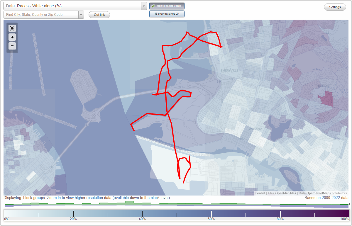
West Oakland neighborhood in Oakland, California (CA), 94607, 94608 detailed profile
Settings
X

Business Search - 14 Million verified businesses
Area: 6.497 square miles
Population: 45,409
Population density:
| West Oakland: | 6,989 people per square mile |
| Oakland: | 7,680 people per square mile |

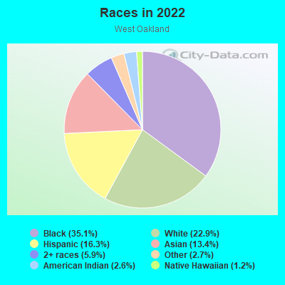
- 16,88335.1%Black
- 11,03822.9%White
- 7,84716.3%Hispanic or Latino
- 6,43313.4%Asian
- 2,8205.9%Two or more races
- 1,3082.7%Some other race
- 1,2452.6%American Indian
- 5771.2%Native Hawaiian and Other
Pacific Islander
Median household income in 2022:
| West Oakland: | $93,481 |
| Oakland: | $93,146 |
Distribution of median household income
![Distribution of median household income]()
- 3,844Less than $10,000
- 5,823$10,000 to $19,999
- 3,344$20,000 to $29,999
- 3,789$30,000 to $39,999
- 2,499$40,000 to $49,999
- 1,126$50,000 to $59,999
- 1,352$60,000 to $74,999
- 1,961$75,000 to $99,999
- 1,561$100,000 to $124,999
- 1,342$125,000 to $149,999
- 1,664$150,000 to $199,999
- 2,900$200,000 or more

Distribution of owner-occupied house/condo value
![Distribution of owner-occupied house/condo value]()
- 2,228Less than $50,000
- 2,283$50,000 to $99,999
- 247$100,000 to $149,999
- 952$150,000 to $199,999
- 862$200,000 to $249,999
- 405$250,000 to $299,999
- 1,863$300,000 to $399,999
- 943$400,000 to $499,999
- 1,514$500,000 to $749,999
- 1,956$750,000 to $999,999
- 2,089$1,000,000 or more

Distribution of rent paid by renters
![Distribution of rent paid by renters]()
- 2,283Less than $100
- 4,661$100 to $199
- 5,218$200 to $299
- 4,471$300 to $399
- 4,714$400 to $499
- 8,456$500 to $599
- 1,783$600 to $699
- 4,243$700 to $799
- 1,708$800 to $899
- 2,339$900 to $999
- 1,361$1,000 to $1,249
- 2,688$1,250 to $1,499
- 2,067$1,500 to $1,999
- 5,388$2,000 or more

| Males: | 23,148 |
| Females: | 22,261 |
Males:
| This neighborhood: | 34.9 years |
| Whole city: | 38.3 years |
| This neighborhood: | 35.2 years |
| Whole city: | 39.1 years |
Average household size:
| West Oakland: | 3.9 people |
| Oakland: | 2.4 people |
Percentage of family households:
| West Oakland: | 32.1% |
| Oakland: | 37.1% |
| Here: | 18.7% |
| Oakland: | 34.9% |
Percentage of married-couple families with children (among all households):
| West Oakland: | 17.4% |
| Oakland: | 28.3% |
Percentage of single-mother households (among all households):
| West Oakland: | 19.8% |
| Oakland: | 9.9% |
Percentage of never married males 15 years old and over:
Percentage of never married females 15 years old and over:
| West Oakland: | 33.1% |
| Oakland: | 24.6% |
Percentage of never married females 15 years old and over:
| West Oakland: | 30.2% |
| city: | 21.9% |
Percentage of people that speak English not well or not at all:
| West Oakland: | 6.2% |
| Oakland: | 10.6% |
Percentage of people born in this state:
Percentage of people born in another U.S. state:
Percentage of native residents but born outside the U.S.:
Percentage of foreign born residents:
| Here: | 52.6% |
| Oakland: | 49.9% |
Percentage of people born in another U.S. state:
| West Oakland: | 24.2% |
| Oakland: | 22.3% |
Percentage of native residents but born outside the U.S.:
| Here: | 1.8% |
| city: | 1.6% |
Percentage of foreign born residents:
| Here: | 21.5% |
| Oakland: | 26.2% |
Owner-occupied
Renter-occupied

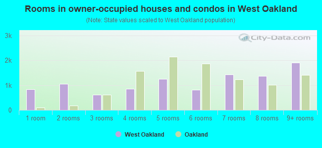
- Rooms in owner-occupied houses and condos in West Oakland
- 8411 room
- 1,0412 rooms
- 6213 rooms
- 8494 rooms
- 1,2495 rooms
- 8156 rooms
- 1,4297 rooms
- 1,3638 rooms
- 1,9109+ rooms
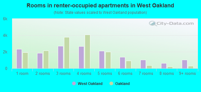
- Rooms in renter-occupied apartments in West Oakland
- 2,3191 room
- 1,8662 rooms
- 2,6873 rooms
- 2,6784 rooms
- 2,1155 rooms
- 1,3576 rooms
- 1,0317 rooms
- 6358 rooms
- 1,0479+ rooms
Owner-occupied
Renter-occupied
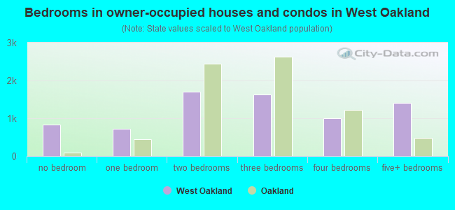
- Bedrooms in owner-occupied houses and condos in West Oakland
- 841no bedroom
- 7251 bedroom
- 1,7032 bedrooms
- 1,6313 bedrooms
- 1,0054 bedrooms
- 1,3995+ bedrooms
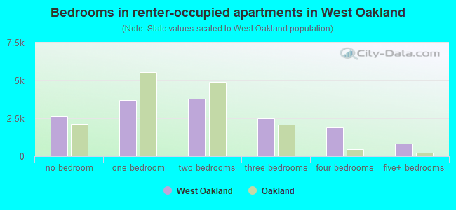
- Bedrooms in renter-occupied apartments in West Oakland
- 2,622no bedroom
- 3,6821 bedroom
- 3,7862 bedrooms
- 2,5103 bedrooms
- 1,8934 bedrooms
- 8565+ bedrooms
Average number of cars or other vehicles available in houses/condos:
Average number of cars or other vehicles available in apartments:
| This neighborhood: | 1.6 |
| Oakland: | 1.8 |
Average number of cars or other vehicles available in apartments:
| Here: | 1.0 |
| city: | 1.1 |
Percentage of units with a mortgage:
| West Oakland: | 81.0% |
| Oakland: | 71.2% |
Average estimated value of detached houses in 2022 (22.0% of all units):
| West Oakland: | $872,403 |
| Oakland: | $1,000,874 |
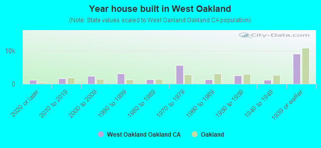
- Year house built in West Oakland
- 1,1952020 or later
- 1,6132010 to 2019
- 2,3942000 to 2009
- 3,0841990 to 1999
- 1,3051980 to 1989
- 5,7671970 to 1979
- 1,3141960 to 1969
- 2,5261950 to 1959
- 1,2751940 to 1949
- 9,1401939 or earlier
City-data.com crime index for city in 2020 (higher means more crime):
| City: | 691.6 |
| U.S. average: | 219.5 |
Travel time to work (commute)
![Travel time to work (commute)]()
- 340Less than 5 minutes
- 1,1535 to 9 minutes
- 2,75110 to 14 minutes
- 3,29315 to 19 minutes
- 2,65820 to 24 minutes
- 85625 to 29 minutes
- 4,28430 to 34 minutes
- 57635 to 39 minutes
- 1,47640 to 44 minutes
- 1,94145 to 59 minutes
- 2,40060 to 89 minutes
- 92190 or more minutes

Means of transportation to work
![Means of transportation to work]()
- 41.6%10,473Drove a car alone
- 6.7%1,680Carpooled
- 15.0%3,769Bus
- 17.0%4,268Subway or elevated rail
- 3.0%747Long-distance train or commuter rail
- 3.0%765Light rail, streetcar or trolley
- 4.6%1,169Ferryboat
- 6.1%1,541Taxi
- 2.4%605Motorcycle
- 3.4%856Bicycle
- 13.6%3,429Walked
- 8.5%2,130Other means
- 15.9%4,002Worked at home

Time leaving home to go to work
![Time leaving home to go to work]()
- 72312:00 a.m. to 4:59 a.m.
- 6235:00 a.m. to 5:29 a.m.
- 2,1565:30 a.m. to 5:59 a.m.
- 1,3116:00 a.m. to 6:29 a.m.
- 1,0366:30 a.m. to 6:59 a.m.
- 1,9907:00 a.m. to 7:29 a.m.
- 2,3717:30 a.m. to 7:59 a.m.
- 3,1348:00 a.m. to 8:29 a.m.
- 2,3018:30 a.m. to 8:59 a.m.
- 2,9569:00 a.m. to 9:59 a.m.
- 1,26310:00 a.m. to 10:59 a.m.
- 54011:00 a.m. to 11:59 a.m.
- 2,23212:00 p.m. to 3:59 p.m.
- 1,1064:00 p.m. to 11:59 p.m.

Occupations of males:
- Percentage of males in management occupations (except farmers):
Here: 12.9% city: 13.5%
- Percentage of males in business and financial operations occupations:
Here: 3.7% city: 6.0%
- Percentage of males in computer and mathematical occupations:
Here: 7.4% city: 7.3%
- Percentage of males in architecture and engineering occupations:
Here: 4.1% city: 3.8%
- Percentage of males in life, physical, and social science occupations:
Here: 1.5% city: 2.0%
- Percentage of males in community and social services occupations:
Here: 1.2% city: 1.5%
- Percentage of males in legal occupations:
Here: 1.6% city: 1.9%
- Percentage of males in education, training, and library occupations:
Here: 5.6% city: 4.6%
- Percentage of males in arts, design, entertainment, sports, and media occupations:
Here: 7.8% city: 4.7%
- Percentage of males in healthcare practitioners and technical occupations:
Here: 2.2% city: 2.8%
- Percentage of males in service occupations:
Here: 13.1% city: 12.9%
- Percentage of males in sales and office occupations:
Here: 15.4% city: 13.4%
- Percentage of males in farming, fishing, and forestry occupations:
Here: 1.8% city: 0.4%
- Percentage of males in construction, extraction, and maintenance occupations:
Here: 5.2% city: 8.3%
- Percentage of males in production occupations:
Here: 2.1% city: 4.2%
- Percentage of males in transportation occupations:
Here: 7.3% city: 5.6%
- Percentage of males in material moving occupations:
Here: 4.4% city: 4.5%
Occupations of females:
- Percentage of females in management occupations (except farmers):
Here: 17.6% city: 15.1%
- Percentage of females in business and financial operations occupations:
Here: 8.5% city: 8.2%
- Percentage of females in computer and mathematical occupations:
Here: 4.8% city: 3.0%
- Percentage of females in architecture and engineering occupations:
Here: 1.6% city: 1.6%
- Percentage of females in life, physical, and social science occupations:
Here: 2.4% city: 2.3%
- Percentage of females in community and social services occupations:
Here: 3.7% city: 3.7%
- Percentage of females in legal occupations:
Here: 1.5% city: 2.5%
- Percentage of females in education, training, and library occupations:
Here: 8.4% city: 8.4%
- Percentage of females in arts, design, entertainment, sports, and media occupations:
Here: 5.3% city: 4.8%
- Percentage of females in healthcare practitioners and technical occupations:
Here: 5.5% city: 6.7%
- Percentage of females in service occupations:
Here: 19.7% city: 17.8%
- Percentage of females in sales and office occupations:
Here: 16.9% city: 20.0%
- Percentage of females in production occupations:
Here: 1.8% city: 2.4%
Percentage of people 16-64 in Armed Forces:
| West Oakland: | 0.1% |
| Oakland: | 0.2% |
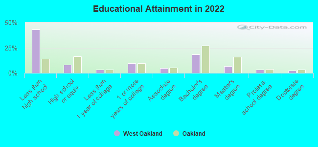
Education in this neighborhood (subdivision or community):
- Percentage of people 3 years and older in K-12 schools:
West Oakland: 29.9% Oakland: 13.0%
- Percentage of people 3 years and older in undergraduate colleges:
West Oakland: 14.5% Oakland: 4.3%
- Percentage of people 3 years and older in grad. or professional schools:
West Oakland: 7.1% Oakland: 1.8%
- Percentage of students K-12 enrolled in private schools:
West Oakland: 39.8% Oakland: 15.8%
Percentage of population below poverty level:
| West Oakland: | 20.9% |
| Oakland: | 13.9% |
Median year renter moved in (as recorded in 2022):
| West Oakland: | 2016 |
| Oakland: | 2018 |
Percentage of married-couple families with both working:
| West Oakland: | 150.7% |
| Oakland: | 73.2% |
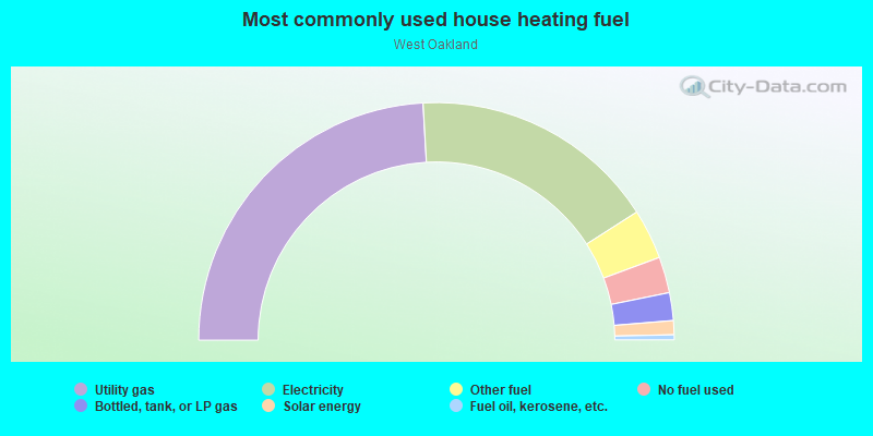
- 48.2%Utility gas
- 33.7%Electricity
- 6.8%Other fuel
- 4.9%No fuel used
- 3.8%Bottled, tank, or LP gas
- 1.9%Solar energy
- 0.7%Fuel oil, kerosene, etc.
Limited-access highways (interstate or state) in this neighborhood:
I- 880
Length: 4.24 miles
Directions: E-W, N-S, SE-NW, SW-NE
Directions: E-W, N-S, SE-NW, SW-NE
I- 980 (Grove Shafter Fwy)
Length: 3.62 miles
Directions: E-W, N-S, SE-NW, SW-NE
Directions: E-W, N-S, SE-NW, SW-NE
I- 580
Length: 3.24 miles
Directions: E-W, N-S, SE-NW, SW-NE
Directions: E-W, N-S, SE-NW, SW-NE
I- 80
Length: 2.24 miles
Directions: E-W, N-S, SW-NE
Directions: E-W, N-S, SW-NE
Roads and streets:
7th St
Length: 4.08 miles
Directions: E-W, N-S, SE-NW, SW-NE
Address range: 601 to 3099
Directions: E-W, N-S, SE-NW, SW-NE
Address range: 601 to 3099
Middle Harbor
Length: 2.75 miles
Directions: E-W, N-S, SE-NW, SW-NE
Directions: E-W, N-S, SE-NW, SW-NE
Mandela Pkwy (Cypress St)
Length: 2.72 miles
Directions: E-W, N-S, SE-NW, SW-NE
Address range: 700 to 2899
Directions: E-W, N-S, SE-NW, SW-NE
Address range: 700 to 2899
Market St
Length: 2.41 miles
Directions: E-W, N-S, SE-NW, SW-NE
Address range: 1 to 3499
Directions: E-W, N-S, SE-NW, SW-NE
Address range: 1 to 3499
14th St
Length: 2.31 miles
Directions: E-W, SE-NW
Address range: 601 to 2699
Directions: E-W, SE-NW
Address range: 601 to 2699
W Grand Ave
Length: 2.27 miles
Directions: E-W, N-S, SE-NW, SW-NE
Address range: 600 to 2199
Directions: E-W, N-S, SE-NW, SW-NE
Address range: 600 to 2199
Peralta St
Length: 2.23 miles
Directions: E-W, N-S, SE-NW, SW-NE
Address range: 300 to 3550
Directions: E-W, N-S, SE-NW, SW-NE
Address range: 300 to 3550
12th St
Length: 2.18 miles
Directions: E-W, N-S, SE-NW
Address range: 1 to 2499
Directions: E-W, N-S, SE-NW
Address range: 1 to 2499
Larson St (10th St)
Length: 2.08 miles
Directions: E-W, SE-NW, SW-NE
Address range: 101 to 2698
Directions: E-W, SE-NW, SW-NE
Address range: 101 to 2698
Adeline St
Length: 2.05 miles
Directions: N-S, SW-NE
Address range: 300 to 3603
Directions: N-S, SW-NE
Address range: 300 to 3603
Middle Harbor Rd
Length: 2.03 miles
Directions: E-W, N-S, SE-NW, SW-NE
Address range: 1300 to 1999
Directions: E-W, N-S, SE-NW, SW-NE
Address range: 1300 to 1999
Martin Luther King Jr Way
Length: 2.01 miles
Directions: E-W, N-S, SE-NW, SW-NE
Address range: 551 to 3499
Directions: E-W, N-S, SE-NW, SW-NE
Address range: 551 to 3499
8th St
Length: 2.00 miles
Directions: E-W, N-S, SE-NW
Address range: 600 to 2099
Directions: E-W, N-S, SE-NW
Address range: 600 to 2099
5th St
Length: 1.98 miles
Directions: E-W, N-S
Address range: 650 to 1899
Directions: E-W, N-S
Address range: 650 to 1899
Adeline
Length: 1.87 miles
Directions: N-S, SW-NE
Directions: N-S, SW-NE
3rd St
Length: 1.84 miles
Directions: E-W, N-S, SE-NW, SW-NE
Address range: 600 to 1699
Directions: E-W, N-S, SE-NW, SW-NE
Address range: 600 to 1699
7th
Length: 1.80 miles
Directions: E-W, SE-NW, SW-NE
Directions: E-W, SE-NW, SW-NE
Maritime St
Length: 1.78 miles
Directions: E-W, N-S, SW-NE
Address range: 700 to 2299
Directions: E-W, N-S, SW-NE
Address range: 700 to 2299
Wood St
Length: 1.74 miles
Directions: N-S, SE-NW, SW-NE
Address range: 200 to 3499
Directions: N-S, SE-NW, SW-NE
Address range: 200 to 3499
Union St
Length: 1.62 miles
Directions: N-S, SE-NW, SW-NE
Address range: 300 to 3299
Directions: N-S, SE-NW, SW-NE
Address range: 300 to 3299
34th St
Length: 1.58 miles
Direction: E-W
Address range: 570 to 1799
Direction: E-W
Address range: 570 to 1799
16th St
Length: 1.56 miles
Directions: E-W, N-S, SE-NW, SW-NE
Address range: 650 to 1799
Directions: E-W, N-S, SE-NW, SW-NE
Address range: 650 to 1799
Chestnut St
Length: 1.56 miles
Directions: E-W, N-S, SE-NW
Address range: 100 to 3599
Directions: E-W, N-S, SE-NW
Address range: 100 to 3599
18th St
Length: 1.55 miles
Directions: E-W, SE-NW, SW-NE
Address range: 646 to 1699
Directions: E-W, SE-NW, SW-NE
Address range: 646 to 1699
Filbert St
Length: 1.53 miles
Directions: N-S, SW-NE
Address range: 300 to 3299
Directions: N-S, SW-NE
Address range: 300 to 3299
14th
Length: 1.52 miles
Directions: E-W, SE-NW
Directions: E-W, SE-NW
West St
Length: 1.51 miles
Directions: E-W, N-S, SW-NE
Address range: 1140 to 3499
Directions: E-W, N-S, SW-NE
Address range: 1140 to 3499
32nd St
Length: 1.44 miles
Direction: E-W
Address range: 598 to 1799
Direction: E-W
Address range: 598 to 1799
Castro St
Length: 1.37 miles
Directions: E-W, N-S, SE-NW, SW-NE
Address range: 200 to 1199
Directions: E-W, N-S, SE-NW, SW-NE
Address range: 200 to 1199
21st St
Length: 1.35 miles
Directions: E-W, SE-NW
Address range: 700 to 1299
Directions: E-W, SE-NW
Address range: 700 to 1299
Campbell St
Length: 1.35 miles
Directions: N-S, SW-NE
Address range: 700 to 2799
Directions: N-S, SW-NE
Address range: 700 to 2799
Magnolia St
Length: 1.32 miles
Directions: E-W, N-S, SE-NW, SW-NE
Address range: 600 to 3599
Directions: E-W, N-S, SE-NW, SW-NE
Address range: 600 to 3599
Brush St
Length: 1.30 miles
Directions: E-W, N-S, SE-NW, SW-NE
Address range: 100 to 2399
Directions: E-W, N-S, SE-NW, SW-NE
Address range: 100 to 2399
17th St
Length: 1.30 miles
Directions: E-W, SE-NW
Address range: 650 to 1799
Directions: E-W, SE-NW
Address range: 650 to 1799
26th St
Length: 1.30 miles
Directions: E-W, SE-NW
Address range: 600 to 1899
Directions: E-W, SE-NW
Address range: 600 to 1899
Linden St (Embarcadero)
Length: 1.29 miles
Directions: N-S, SW-NE
Address range: 1 to 3499
Directions: N-S, SW-NE
Address range: 1 to 3499
Embarcadero W (1st St)
Length: 1.28 miles
Direction: E-W
Address range: 600 to 1199
Direction: E-W
Address range: 600 to 1199
W Grand
Length: 1.26 miles
Directions: E-W, SE-NW
Directions: E-W, SE-NW
28th St
Length: 1.25 miles
Directions: E-W, SE-NW, SW-NE
Address range: 500 to 1699
Directions: E-W, SE-NW, SW-NE
Address range: 500 to 1699
San Pablo Ave
Length: 1.25 miles
Directions: E-W, N-S, SE-NW, SW-NE
Address range: 2000 to 3579
Directions: E-W, N-S, SE-NW, SW-NE
Address range: 2000 to 3579
Market
Length: 1.24 miles
Directions: E-W, N-S, SW-NE
Directions: E-W, N-S, SW-NE
Myrtle St (Embarcadero)
Length: 1.23 miles
Directions: N-S, SW-NE
Address range: 100 to 3199
Directions: N-S, SW-NE
Address range: 100 to 3199
Terminal St
Length: 1.21 miles
Directions: E-W, SW-NE
Address range: 900 to 1999
Directions: E-W, SW-NE
Address range: 900 to 1999
30th St
Length: 1.21 miles
Direction: E-W
Address range: 500 to 1299
Direction: E-W
Address range: 500 to 1299
11th St (Andrew Way)
Length: 1.20 miles
Directions: E-W, N-S, SE-NW, SW-NE
Address range: 600 to 2799
Directions: E-W, N-S, SE-NW, SW-NE
Address range: 600 to 2799
Poplar St
Length: 1.15 miles
Directions: E-W, N-S, SE-NW, SW-NE
Address range: 1000 to 2999
Directions: E-W, N-S, SE-NW, SW-NE
Address range: 1000 to 2999
Burma Rd
Length: 1.15 miles
Directions: E-W, SW-NE
Address range: 1 to 299
Directions: E-W, SW-NE
Address range: 1 to 299
12th
Length: 1.15 miles
Directions: E-W, N-S, SE-NW
Directions: E-W, N-S, SE-NW
Willow St
Length: 1.14 miles
Directions: N-S, SW-NE
Address range: 700 to 2699
Directions: N-S, SW-NE
Address range: 700 to 2699
24th St
Length: 1.12 miles
Directions: E-W, SE-NW, SW-NE
Address range: 588 to 1799
Directions: E-W, SE-NW, SW-NE
Address range: 588 to 1799
4th St
Length: 1.07 miles
Directions: E-W, N-S, SE-NW, SW-NE
Address range: 600 to 999
Directions: E-W, N-S, SE-NW, SW-NE
Address range: 600 to 999
15th St
Length: 1.05 miles
Directions: E-W, N-S, SE-NW
Address range: 644 to 1799
Directions: E-W, N-S, SE-NW
Address range: 644 to 1799
Tulagi St
Length: 0.96 miles
Direction: SW-NE
Direction: SW-NE
Gang Way
Length: 0.96 miles
Directions: E-W, N-S, SE-NW
Directions: E-W, N-S, SE-NW
San Pablo
Length: 0.93 miles
Direction: N-S
Direction: N-S
16th
Length: 0.89 miles
Directions: E-W, SE-NW
Directions: E-W, SE-NW
8th
Length: 0.87 miles
Directions: E-W, N-S, SE-NW, SW-NE
Directions: E-W, N-S, SE-NW, SW-NE
Army Base
Length: 0.85 miles
Directions: E-W, SW-NE
Address range: 600 to 899
Directions: E-W, SW-NE
Address range: 600 to 899
Peralta
Length: 0.85 miles
Direction: SW-NE
Direction: SW-NE
35th St
Length: 0.84 miles
Directions: E-W, SE-NW
Address range: 600 to 1199
Directions: E-W, SE-NW
Address range: 600 to 1199
Murmansk St
Length: 0.81 miles
Directions: E-W, N-S, SE-NW, SW-NE
Directions: E-W, N-S, SE-NW, SW-NE
Destroyer Way
Length: 0.80 miles
Direction: E-W
Direction: E-W
19th St
Length: 0.79 miles
Directions: E-W, SE-NW
Address range: 600 to 1299
Directions: E-W, SE-NW
Address range: 600 to 1299
15th
Length: 0.78 miles
Directions: E-W, N-S, SE-NW
Directions: E-W, N-S, SE-NW
1st St
Length: 0.78 miles
Directions: E-W, N-S, SW-NE
Directions: E-W, N-S, SW-NE
Commodore Way
Length: 0.78 miles
Direction: E-W
Direction: E-W
18th
Length: 0.78 miles
Directions: E-W, SE-NW
Directions: E-W, SE-NW
20th St
Length: 0.77 miles
Directions: E-W, SE-NW
Address range: 633 to 1799
Directions: E-W, SE-NW
Address range: 633 to 1799
Wake Ave
Length: 0.76 miles
Directions: E-W, SE-NW, SW-NE
Address range: 1000 to 2099
Directions: E-W, SE-NW, SW-NE
Address range: 1000 to 2099
13th St
Length: 0.75 miles
Directions: E-W, SE-NW
Address range: 700 to 1799
Directions: E-W, SE-NW
Address range: 700 to 1799
Ferry St
Length: 0.69 miles
Directions: E-W, N-S, SE-NW, SW-NE
Address range: 700 to 1699
Directions: E-W, N-S, SE-NW, SW-NE
Address range: 700 to 1699
Interstate 880 N
Length: 0.68 miles
Directions: E-W, N-S, SE-NW
Directions: E-W, N-S, SE-NW
Center St
Length: 0.68 miles
Direction: N-S
Address range: 300 to 1799
Direction: N-S
Address range: 300 to 1799
Boatswain Way
Length: 0.67 miles
Direction: E-W
Direction: E-W
Executive Way
Length: 0.65 miles
Direction: E-W
Address range: 250 to 298
Direction: E-W
Address range: 250 to 298
31st St
Length: 0.65 miles
Directions: E-W, N-S, SE-NW, SW-NE
Address range: 500 to 999
Directions: E-W, N-S, SE-NW, SW-NE
Address range: 500 to 999
Bay Pl (27th St)
Length: 0.60 miles
Directions: E-W, SE-NW, SW-NE
Address range: 600 to 899
Directions: E-W, SE-NW, SW-NE
Address range: 600 to 899
29th St
Length: 0.60 miles
Directions: E-W, SE-NW
Address range: 500 to 899
Directions: E-W, SE-NW
Address range: 500 to 899
2nd St
Length: 0.59 miles
Directions: E-W, N-S, SW-NE
Address range: 600 to 799
Directions: E-W, N-S, SW-NE
Address range: 600 to 799
6th St
Length: 0.59 miles
Directions: N-S, SW-NE
Directions: N-S, SW-NE
Kirkham St
Length: 0.58 miles
Directions: N-S, SE-NW, SW-NE
Address range: 500 to 2599
Directions: N-S, SE-NW, SW-NE
Address range: 500 to 2599
Poplar
Length: 0.57 miles
Directions: N-S, SW-NE
Directions: N-S, SW-NE
Engineer Rd
Length: 0.57 miles
Direction: E-W
Address range: 2000 to 2099
Direction: E-W
Address range: 2000 to 2099
(Interstate 580)
Length: 0.56 miles
Direction: E-W
Direction: E-W
9th
Length: 0.55 miles
Direction: N-S
Direction: N-S
9th St
Length: 0.55 miles
Directions: E-W, SE-NW
Address range: 1400 to 1899
Directions: E-W, SE-NW
Address range: 1400 to 1899
Moorship Ave
Length: 0.53 miles
Direction: E-W
Address range: 1600 to 1799
Direction: E-W
Address range: 1600 to 1799
Shellmound St
Length: 0.52 miles
Directions: E-W, N-S, SE-NW, SW-NE
Address range: 1450 to 1599
Directions: E-W, N-S, SE-NW, SW-NE
Address range: 1450 to 1599
Tobruk St
Length: 0.52 miles
Direction: SW-NE
Direction: SW-NE
Chester St
Length: 0.52 miles
Direction: N-S
Address range: 300 to 1199
Direction: N-S
Address range: 300 to 1199
33rd St
Length: 0.52 miles
Direction: E-W
Address range: 600 to 999
Direction: E-W
Address range: 600 to 999
Brockhurst St
Length: 0.51 miles
Directions: E-W, SE-NW
Address range: 600 to 999
Directions: E-W, SE-NW
Address range: 600 to 999
Hull Way
Length: 0.50 miles
Direction: E-W
Direction: E-W
Inventory Ave
Length: 0.50 miles
Direction: E-W
Direction: E-W
Keel Way
Length: 0.50 miles
Direction: E-W
Direction: E-W
Logistics Ln
Length: 0.50 miles
Direction: E-W
Direction: E-W
Warehouse Rd
Length: 0.48 miles
Directions: E-W, SE-NW, SW-NE
Directions: E-W, SE-NW, SW-NE
Pine St
Length: 0.46 miles
Directions: N-S, SW-NE
Address range: 500 to 1199
Directions: N-S, SW-NE
Address range: 500 to 1199
Corregidor Ave
Length: 0.44 miles
Directions: E-W, N-S, SE-NW, SW-NE
Directions: E-W, N-S, SE-NW, SW-NE
Village Cir
Length: 0.42 miles
Directions: E-W, N-S
Address range: 800 to 999
Directions: E-W, N-S
Address range: 800 to 999
Embarcadero (Magnolia St)
Length: 0.42 miles
Directions: N-S, SW-NE
Address range: 100 to 299
Directions: N-S, SW-NE
Address range: 100 to 299
11th
Length: 0.41 miles
Directions: E-W, N-S, SE-NW, SW-NE
Directions: E-W, N-S, SE-NW, SW-NE
Algiers St
Length: 0.40 miles
Directions: SE-NW, SW-NE
Directions: SE-NW, SW-NE
Pier St
Length: 0.39 miles
Directions: SE-NW, SW-NE
Address range: 2300 to 2699
Directions: SE-NW, SW-NE
Address range: 2300 to 2699
3rd
Length: 0.38 miles
Directions: E-W, N-S, SE-NW
Directions: E-W, N-S, SE-NW
E H
Length: 0.37 miles
Direction: E-W
Direction: E-W
10th
Length: 0.36 miles
Directions: E-W, N-S, SE-NW, SW-NE
Directions: E-W, N-S, SE-NW, SW-NE
Ettie St
Length: 0.36 miles
Direction: N-S
Address range: 2800 to 3499
Direction: N-S
Address range: 2800 to 3499
West
Length: 0.35 miles
Directions: E-W, N-S, SW-NE
Directions: E-W, N-S, SW-NE
Northgate
Length: 0.35 miles
Directions: N-S, SW-NE
Directions: N-S, SW-NE
Hannah St
Length: 0.35 miles
Directions: N-S, SW-NE
Address range: 2800 to 3499
Directions: N-S, SW-NE
Address range: 2800 to 3499
23rd St
Length: 0.35 miles
Directions: E-W, N-S, SE-NW
Address range: 587 to 799
Directions: E-W, N-S, SE-NW
Address range: 587 to 799
Fleet Way
Length: 0.34 miles
Directions: E-W, SE-NW
Address range: 220 to 260
Directions: E-W, SE-NW
Address range: 220 to 260
Cedar St
Length: 0.34 miles
Directions: N-S, SW-NE
Address range: 501 to 899
Directions: N-S, SW-NE
Address range: 501 to 899
Anchor St (Anchor Way)
Length: 0.33 miles
Direction: E-W
Direction: E-W
Midway St
Length: 0.33 miles
Directions: N-S, SW-NE
Address range: 300 to 2699
Directions: N-S, SW-NE
Address range: 300 to 2699
22nd St
Length: 0.33 miles
Direction: E-W
Address range: 650 to 899
Direction: E-W
Address range: 650 to 899
Ferro St
Length: 0.32 miles
Directions: E-W, N-S, SE-NW, SW-NE
Address range: 1600 to 1799
Directions: E-W, N-S, SE-NW, SW-NE
Address range: 1600 to 1799
Martin Luther King Jr
Length: 0.32 miles
Direction: N-S
Direction: N-S
Freight St
Length: 0.32 miles
Directions: E-W, SE-NW
Address range: 2400 to 2699
Directions: E-W, SE-NW
Address range: 2400 to 2699
Henry St
Length: 0.31 miles
Directions: N-S, SW-NE
Address range: 300 to 899
Directions: N-S, SW-NE
Address range: 300 to 899
Northgate Ave
Length: 0.31 miles
Directions: N-S, SE-NW, SW-NE
Address range: 2200 to 2499
Directions: N-S, SE-NW, SW-NE
Address range: 2200 to 2499
Helen St
Length: 0.30 miles
Direction: N-S
Address range: 2800 to 3499
Direction: N-S
Address range: 2800 to 3499
Petroleum St
Length: 0.30 miles
Directions: E-W, SE-NW
Address range: 2400 to 2699
Directions: E-W, SE-NW
Address range: 2400 to 2699
Ferry
Length: 0.30 miles
Directions: E-W, SE-NW, SW-NE
Directions: E-W, SE-NW, SW-NE
Africa St
Length: 0.30 miles
Directions: E-W, N-S, SW-NE
Directions: E-W, N-S, SW-NE
27th
Length: 0.29 miles
Direction: E-W
Direction: E-W
Sycamore St
Length: 0.29 miles
Directions: E-W, SW-NE
Address range: 600 to 799
Directions: E-W, SW-NE
Address range: 600 to 799
Grove St (Martin Luther King Jr Way)
Length: 0.28 miles
Direction: SW-NE
Address range: 1 to 549
Direction: SW-NE
Address range: 1 to 549
Telegraph Ave
Length: 0.27 miles
Direction: N-S
Address range: 2801 to 3103
Direction: N-S
Address range: 2801 to 3103
Bataan Ave
Length: 0.27 miles
Directions: N-S, SE-NW
Directions: N-S, SE-NW
Yerba Buena Ave
Length: 0.26 miles
Directions: E-W, N-S
Address range: 1451 to 1699
Directions: E-W, N-S
Address range: 1451 to 1699
Louise St
Length: 0.25 miles
Direction: N-S
Address range: 3000 to 3499
Direction: N-S
Address range: 3000 to 3499
Athens Ave
Length: 0.25 miles
Direction: E-W
Address range: 800 to 899
Direction: E-W
Address range: 800 to 899
Terminal
Length: 0.24 miles
Direction: E-W
Direction: E-W
Mead Ave
Length: 0.24 miles
Directions: E-W, SE-NW
Address range: 800 to 899
Directions: E-W, SE-NW
Address range: 800 to 899
Jefferson St
Length: 0.24 miles
Direction: SW-NE
Address range: 1 to 409
Direction: SW-NE
Address range: 1 to 409
Goss St
Length: 0.24 miles
Direction: E-W
Address range: 1700 to 1899
Direction: E-W
Address range: 1700 to 1899
Hollis St
Length: 0.23 miles
Directions: N-S, SE-NW
Address range: 3200 to 3499
Directions: N-S, SE-NW
Address range: 3200 to 3499
6th
Length: 0.22 miles
Directions: E-W, N-S
Directions: E-W, N-S
E E
Length: 0.22 miles
Direction: E-W
Direction: E-W
Alaska St
Length: 0.21 miles
Directions: E-W, SE-NW
Directions: E-W, SE-NW
Mandela Pkwy
Length: 0.21 miles
Directions: N-S, SE-NW, SW-NE
Address range: 300 to 499
Directions: N-S, SE-NW, SW-NE
Address range: 300 to 499
Isabella St
Length: 0.20 miles
Direction: E-W
Address range: 800 to 998
Direction: E-W
Address range: 800 to 998
Beach St
Length: 0.20 miles
Directions: N-S, SE-NW, SW-NE
Address range: 3300 to 4149
Directions: N-S, SE-NW, SW-NE
Address range: 3300 to 4149
Lewis St
Length: 0.20 miles
Directions: N-S, SE-NW
Address range: 201 to 599
Directions: N-S, SE-NW
Address range: 201 to 599
25th St
Length: 0.20 miles
Direction: E-W
Address range: 592 to 799
Direction: E-W
Address range: 592 to 799
20th
Length: 0.19 miles
Direction: E-W
Direction: E-W
Navy Roadway
Length: 0.19 miles
Direction: SE-NW
Direction: SE-NW
Halleck St
Length: 0.18 miles
Directions: E-W, N-S, SW-NE
Address range: 4000 to 4199
Directions: E-W, N-S, SW-NE
Address range: 4000 to 4199
Urkraine St
Length: 0.17 miles
Direction: SE-NW
Address range: 2400 to 2499
Direction: SE-NW
Address range: 2400 to 2499
Chase St
Length: 0.17 miles
Direction: SE-NW
Address range: 1700 to 1799
Direction: SE-NW
Address range: 1700 to 1799
36th St
Length: 0.17 miles
Direction: E-W
Address range: 1100 to 1199
Direction: E-W
Address range: 1100 to 1199
Inventory
Length: 0.17 miles
Directions: E-W, N-S, SE-NW
Directions: E-W, N-S, SE-NW
Campbell Village Ct
Length: 0.16 miles
Direction: SW-NE
Address range: 719 to 999
Direction: SW-NE
Address range: 719 to 999
Milton St
Length: 0.16 miles
Direction: E-W
Address range: 800 to 899
Direction: E-W
Address range: 800 to 899
Curtis St
Length: 0.16 miles
Direction: SW-NE
Address range: 2000 to 2299
Direction: SW-NE
Address range: 2000 to 2299
13th
Length: 0.16 miles
Direction: N-S
Direction: N-S
Buna St
Length: 0.15 miles
Directions: E-W, N-S
Address range: 100 to 120
Directions: E-W, N-S
Address range: 100 to 120
Chungking St
Length: 0.15 miles
Direction: E-W
Direction: E-W
5th
Length: 0.15 miles
Directions: E-W, N-S
Directions: E-W, N-S
Poplar Ct (Poplar Way)
Length: 0.14 miles
Directions: N-S, SW-NE
Address range: 800 to 999
Directions: N-S, SW-NE
Address range: 800 to 999
Kirkham Ct (Kirkham St)
Length: 0.14 miles
Directions: E-W, N-S
Address range: 1200 to 1399
Directions: E-W, N-S
Address range: 1200 to 1399
Attu St
Length: 0.13 miles
Directions: E-W, SW-NE
Directions: E-W, SW-NE
Haven St
Length: 0.12 miles
Direction: N-S
Address range: 3200 to 3499
Direction: N-S
Address range: 3200 to 3499
Chestnut Ct (Chestnut St)
Length: 0.12 miles
Direction: N-S
Address range: 2200 to 2399
Direction: N-S
Address range: 2200 to 2399
Dolphin St
Length: 0.10 miles
Direction: E-W
Direction: E-W
Covent Ln
Length: 0.10 miles
Directions: E-W, N-S, SW-NE
Directions: E-W, N-S, SW-NE
26th
Length: 0.10 miles
Direction: SE-NW
Direction: SE-NW
Motor Pool Way
Length: 0.10 miles
Directions: N-S, SE-NW
Address range: 1 to 99
Directions: N-S, SE-NW
Address range: 1 to 99
Horton St
Length: 0.09 miles
Directions: N-S, SE-NW
Address range: 3900 to 3999
Directions: N-S, SE-NW
Address range: 3900 to 3999
Interstate 880 S
Length: 0.09 miles
Directions: N-S, SE-NW
Directions: N-S, SE-NW
Alicia St
Length: 0.09 miles
Directions: E-W, N-S, SE-NW
Address range: 2700 to 2799
Directions: E-W, N-S, SE-NW
Address range: 2700 to 2799
Bay St
Length: 0.09 miles
Direction: N-S
Address range: 400 to 799
Direction: N-S
Address range: 400 to 799
Moss Ln
Length: 0.08 miles
Directions: E-W, N-S, SW-NE
Directions: E-W, N-S, SW-NE
Fitzgerald St
Length: 0.08 miles
Directions: E-W, SW-NE
Directions: E-W, SW-NE
Ambler Ln
Length: 0.07 miles
Direction: E-W
Direction: E-W
Transit St
Length: 0.07 miles
Direction: SE-NW
Address range: 2600 to 2699
Direction: SE-NW
Address range: 2600 to 2699
Maritime
Length: 0.06 miles
Directions: N-S, SW-NE
Directions: N-S, SW-NE
McElroy St
Length: 0.06 miles
Direction: SW-NE
Address range: 849 to 899
Direction: SW-NE
Address range: 849 to 899
Foot of Wood (Wood St)
Length: 0.06 miles
Direction: SW-NE
Address range: 1700 to 1799
Direction: SW-NE
Address range: 1700 to 1799
Ealing Ln
Length: 0.06 miles
Directions: E-W, N-S, SW-NE
Directions: E-W, N-S, SW-NE
Interstate 980 E
Length: 0.06 miles
Direction: SW-NE
Direction: SW-NE
Tobruk
Length: 0.05 miles
Directions: N-S, SW-NE
Directions: N-S, SW-NE
40th
Length: 0.05 miles
Direction: E-W
Direction: E-W
Baku St
Length: 0.05 miles
Direction: N-S
Direction: N-S
Center
Length: 0.05 miles
Direction: N-S
Direction: N-S
Harlan St
Length: 0.05 miles
Direction: N-S
Address range: 3400 to 3599
Direction: N-S
Address range: 3400 to 3599
Park Ave
Length: 0.05 miles
Direction: E-W
Address range: 1550 to 1599
Direction: E-W
Address range: 1550 to 1599
I- 80 E
Length: 0.05 miles
Direction: E-W
Direction: E-W
4th
Length: 0.05 miles
Direction: N-S
Direction: N-S
Shorey St
Length: 0.04 miles
Direction: E-W
Address range: 1800 to 1899
Direction: E-W
Address range: 1800 to 1899
Orient St
Length: 0.03 miles
Direction: SW-NE
Address range: 900 to 1199
Direction: SW-NE
Address range: 900 to 1199
Surryhne St
Length: 0.03 miles
Direction: N-S
Address range: 3200 to 3299
Direction: N-S
Address range: 3200 to 3299
Hubbard St
Length: 0.03 miles
Direction: N-S
Address range: 4000 to 4045
Direction: N-S
Address range: 4000 to 4045
Cypress
Length: 0.03 miles
Directions: E-W, N-S, SW-NE
Directions: E-W, N-S, SW-NE
Palm Ct
Length: 0.03 miles
Direction: N-S
Direction: N-S
Merrimac St
Length: 0.03 miles
Direction: E-W
Address range: 600 to 649
Direction: E-W
Address range: 600 to 649
17th
Length: 0.02 miles
Direction: SE-NW
Direction: SE-NW
30th
Length: 0.02 miles
Direction: E-W
Direction: E-W
Railroad features:
Union Pacific RR
Length: 8.55 miles
Directions: E-W, N-S, SE-NW, SW-NE
Directions: E-W, N-S, SE-NW, SW-NE
Bay Area Rapid Transit RR
Length: 3.09 miles
Directions: E-W, N-S, SE-NW, SW-NE
Directions: E-W, N-S, SE-NW, SW-NE