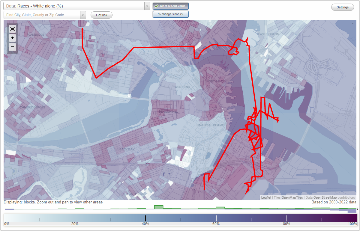
West Broadway (D Street) neighborhood in Boston, Massachusetts (MA), 02127, 02210 detailed profile
Settings
X

Business Search - 14 Million verified businesses
Area: 1.694 square miles
Population: 58,758
Population density:
| West Broadway (D Street): | 34,695 people per square mile |
| Boston: | 13,418 people per square mile |

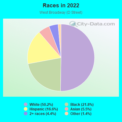
- 35,80850.2%White
- 15,56721.8%Black
- 11,80516.6%Hispanic or Latino
- 3,9415.5%Asian
- 3,1604.4%Two or more races
- 9961.4%Some other race
Distribution of median household income
![Distribution of median household income]()
- 2,988Less than $10,000
- 6,535$10,000 to $19,999
- 5,967$20,000 to $29,999
- 2,285$30,000 to $39,999
- 4,181$40,000 to $49,999
- 1,570$50,000 to $59,999
- 1,993$60,000 to $74,999
- 2,057$75,000 to $99,999
- 2,775$100,000 to $124,999
- 1,649$125,000 to $149,999
- 4,997$150,000 to $199,999
- 12,427$200,000 or more

Distribution of owner-occupied house/condo value
![Distribution of owner-occupied house/condo value]()
- 480$100,000 to $149,999
- 1,098$250,000 to $299,999
- 1,295$300,000 to $399,999
- 4,390$400,000 to $499,999
- 5,390$500,000 to $749,999
- 3,817$750,000 to $999,999
- 5,979$1,000,000 or more

Distribution of rent paid by renters
![Distribution of rent paid by renters]()
- 1,536Less than $100
- 3,288$100 to $199
- 1,763$200 to $299
- 7,595$300 to $399
- 2,863$400 to $499
- 5,763$500 to $599
- 3,066$600 to $699
- 824$700 to $799
- 2,218$800 to $899
- 625$900 to $999
- 1,528$1,000 to $1,249
- 2,421$1,250 to $1,499
- 2,370$1,500 to $1,999
- 11,543$2,000 or more

Median rent in 2022:
| West Broadway (D Street): | $2,138 |
| Boston: | $1,814 |
| Males: | 25,701 |
| Females: | 33,056 |
Males:
| This neighborhood: | 34.1 years |
| Whole city: | 32.7 years |
| This neighborhood: | 36.0 years |
| Whole city: | 34.1 years |
Average household size:
| West Broadway (D Street): | 2.1 people |
| Boston: | 2.1 people |
Percentage of family households:
| West Broadway (D Street): | 28.5% |
| Boston: | 34.5% |
| Here: | 22.4% |
| Boston: | 26.9% |
Percentage of married-couple families with children (among all households):
| West Broadway (D Street): | 26.9% |
| Boston: | 24.9% |
Percentage of single-mother households (among all households):
| West Broadway (D Street): | 34.4% |
| Boston: | 15.7% |
Percentage of never married males 15 years old and over:
Percentage of never married females 15 years old and over:
| West Broadway (D Street): | 25.2% |
| Boston: | 26.8% |
Percentage of never married females 15 years old and over:
| West Broadway (D Street): | 32.3% |
| city: | 28.3% |
Percentage of people that speak English not well or not at all:
| West Broadway (D Street): | 9.5% |
| Boston: | 8.0% |
Percentage of people born in this state:
Percentage of people born in another U.S. state:
Percentage of native residents but born outside the U.S.:
Percentage of foreign born residents:
| Here: | 50.0% |
| Boston: | 42.4% |
Percentage of people born in another U.S. state:
| West Broadway (D Street): | 28.0% |
| Boston: | 26.6% |
Percentage of native residents but born outside the U.S.:
| Here: | 1.4% |
| city: | 3.3% |
Percentage of foreign born residents:
| Here: | 20.6% |
| Boston: | 27.6% |
Owner-occupied
Renter-occupied

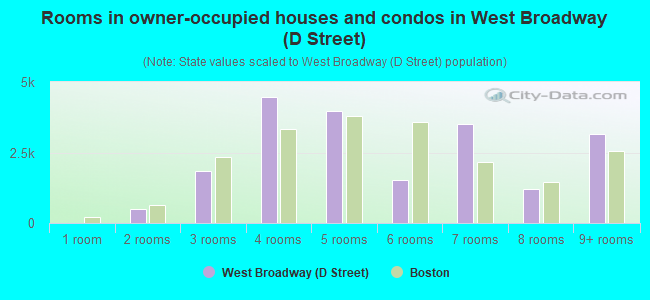
- Rooms in owner-occupied houses and condos in West Broadway <
> - 01 room
- 4802 rooms
- 1,8343 rooms
- 4,4674 rooms
- 3,9615 rooms
- 1,5166 rooms
- 3,5237 rooms
- 1,2208 rooms
- 3,1549+ rooms
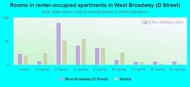
- Rooms in renter-occupied apartments in West Broadway <
> - 2,4081 room
- 8142 rooms
- 8,9393 rooms
- 4,1064 rooms
- 3,5885 rooms
- 1,0226 rooms
- 6667 rooms
- 7358 rooms
- 7209+ rooms
Owner-occupied
Renter-occupied
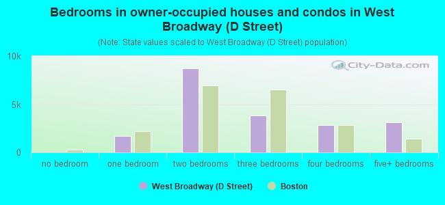
- Bedrooms in owner-occupied houses and condos in West Broadway <
> - 0no bedroom
- 1,6741 bedroom
- 8,7002 bedrooms
- 3,8093 bedrooms
- 2,8544 bedrooms
- 3,1545+ bedrooms
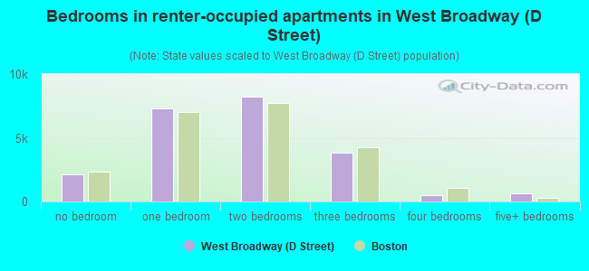
- Bedrooms in renter-occupied apartments in West Broadway <
> - 2,161no bedroom
- 7,3371 bedroom
- 8,2082 bedrooms
- 3,8243 bedrooms
- 5184 bedrooms
- 6495+ bedrooms
Average number of cars or other vehicles available in houses/condos:
Average number of cars or other vehicles available in apartments:
| This neighborhood: | |
| Boston: |
Average number of cars or other vehicles available in apartments:
| Here: | 0.6 |
| city: | 0.7 |
Percentage of units with a mortgage:
| West Broadway (D Street): | 83.6% |
| Boston: | 69.7% |
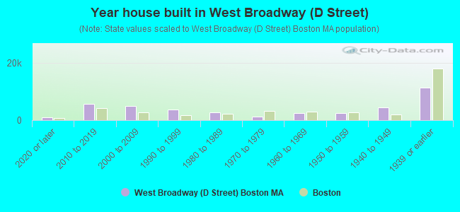
- Year house built in West Broadway <
> - 9592020 or later
- 5,7712010 to 2019
- 4,8392000 to 2009
- 3,8071990 to 1999
- 2,7481980 to 1989
- 1,2451970 to 1979
- 2,5551960 to 1969
- 2,4751950 to 1959
- 4,3641940 to 1949
- 11,1791939 or earlier
City-data.com crime index for city in 2020 (higher means more crime):
| City: | 258.2 |
| U.S. average: | 219.5 |
Travel time to work (commute)
![Travel time to work (commute)]()
- 555Less than 5 minutes
- 2,8375 to 9 minutes
- 1,48610 to 14 minutes
- 3,30015 to 19 minutes
- 2,61620 to 24 minutes
- 2,65425 to 29 minutes
- 7,30630 to 34 minutes
- 1,65335 to 39 minutes
- 63640 to 44 minutes
- 2,00745 to 59 minutes
- 1,98460 to 89 minutes
- 55590 or more minutes

Means of transportation to work
![Means of transportation to work]()
- 33.3%12,877Drove a car alone
- 3.8%1,458Carpooled
- 17.6%6,815Bus
- 12.4%4,782Subway or elevated rail
- 1.1%420Long-distance train or commuter rail
- 6.8%2,640Light rail, streetcar or trolley
- 2.6%1,002Taxi
- 2.7%1,028Motorcycle
- 2.4%937Bicycle
- 10.3%3,995Walked
- 8.1%3,116Other means
- 20.3%7,836Worked at home

Time leaving home to go to work
![Time leaving home to go to work]()
- 34712:00 a.m. to 4:59 a.m.
- 6545:00 a.m. to 5:29 a.m.
- 3375:30 a.m. to 5:59 a.m.
- 8006:00 a.m. to 6:29 a.m.
- 1,3536:30 a.m. to 6:59 a.m.
- 4,8687:00 a.m. to 7:29 a.m.
- 4,6107:30 a.m. to 7:59 a.m.
- 5,8798:00 a.m. to 8:29 a.m.
- 2,8578:30 a.m. to 8:59 a.m.
- 2,5519:00 a.m. to 9:59 a.m.
- 69710:00 a.m. to 10:59 a.m.
- 1,06311:00 a.m. to 11:59 a.m.
- 71912:00 p.m. to 3:59 p.m.
- 7574:00 p.m. to 11:59 p.m.

Occupations of males:
- Percentage of males in management occupations (except farmers):
Here: 19.9% city: 12.7%
- Percentage of males in business and financial operations occupations:
Here: 14.1% city: 9.1%
- Percentage of males in computer and mathematical occupations:
Here: 8.7% city: 7.4%
- Percentage of males in architecture and engineering occupations:
Here: 3.6% city: 3.1%
- Percentage of males in life, physical, and social science occupations:
Here: 3.7% city: 3.9%
- Percentage of males in legal occupations:
Here: 2.2% city: 2.5%
- Percentage of males in healthcare practitioners and technical occupations:
Here: 4.3% city: 4.4%
- Percentage of males in service occupations:
Here: 15.3% city: 16.0%
- Percentage of males in sales and office occupations:
Here: 21.6% city: 15.2%
- Percentage of males in construction, extraction, and maintenance occupations:
Here: 1.4% city: 4.4%
- Percentage of males in transportation occupations:
Here: 2.4% city: 4.7%
- Percentage of males in material moving occupations:
Here: 1.6% city: 2.3%
Occupations of females:
- Percentage of females in management occupations (except farmers):
Here: 13.2% city: 12.2%
- Percentage of females in business and financial operations occupations:
Here: 12.2% city: 9.5%
- Percentage of females in computer and mathematical occupations:
Here: 8.6% city: 3.2%
- Percentage of females in architecture and engineering occupations:
Here: 2.1% city: 1.0%
- Percentage of females in life, physical, and social science occupations:
Here: 6.6% city: 3.3%
- Percentage of females in community and social services occupations:
Here: 7.5% city: 3.1%
- Percentage of females in legal occupations:
Here: 1.5% city: 2.3%
- Percentage of females in education, training, and library occupations:
Here: 2.2% city: 9.4%
- Percentage of females in arts, design, entertainment, sports, and media occupations:
Here: 4.9% city: 3.4%
- Percentage of females in healthcare practitioners and technical occupations:
Here: 8.6% city: 10.2%
- Percentage of females in service occupations:
Here: 10.3% city: 18.6%
- Percentage of females in sales and office occupations:
Here: 22.4% city: 20.2%
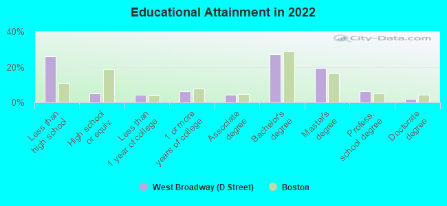
Education in this neighborhood (subdivision or community):
- Percentage of people 3 years and older in K-12 schools:
West Broadway (D Street): 23.6% Boston: 11.0%
- Percentage of people 3 years and older in undergraduate colleges:
West Broadway (D Street): 7.7% Boston: 11.0%
- Percentage of people 3 years and older in grad. or professional schools:
West Broadway (D Street): 13.5% Boston: 4.3%
- Percentage of students K-12 enrolled in private schools:
West Broadway (D Street): 6.4% Boston: 13.8%
Percentage of population below poverty level:
| West Broadway (D Street): | 14.4% |
| Boston: | 17.1% |
Median year renter moved in (as recorded in 2022):
| West Broadway (D Street): | 2015 |
| Boston: | 2020 |
Percentage of married-couple families with both working:
| West Broadway (D Street): | 94.3% |
| Boston: | 78.2% |
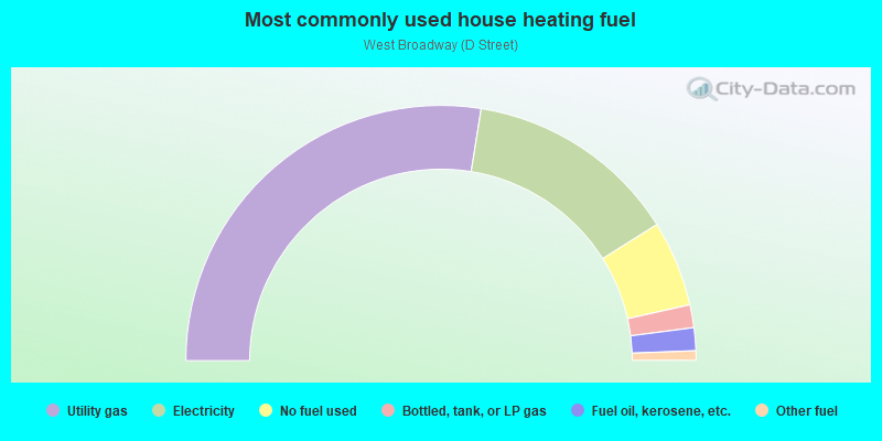
- 55.1%Utility gas
- 27.1%Electricity
- 10.9%No fuel used
- 2.9%Bottled, tank, or LP gas
- 2.9%Fuel oil, kerosene, etc.
- 1.2%Other fuel
Limited-access highways (interstate or state) in this neighborhood:
Massachusetts Tpke (I- 90)
Length: 2.75 miles
Directions: E-W, SW-NE
Directions: E-W, SW-NE
Roads and streets:
Summer St
Length: 1.92 miles
Directions: E-W, N-S, SE-NW
Address range: 256 to 899
Directions: E-W, N-S, SE-NW
Address range: 256 to 899
N380
Length: 1.53 miles
Directions: SE-NW, SW-NE
Directions: SE-NW, SW-NE
E 1st St
Length: 1.31 miles
Direction: E-W
Address range: 1 to 999
Direction: E-W
Address range: 1 to 999
D St
Length: 1.18 miles
Direction: SW-NE
Address range: 101 to 499
Direction: SW-NE
Address range: 101 to 499
E St
Length: 1.18 miles
Direction: SW-NE
Address range: 151 to 675
Direction: SW-NE
Address range: 151 to 675
B St
Length: 1.15 miles
Directions: E-W, SE-NW, SW-NE
Address range: 7 to 399
Directions: E-W, SE-NW, SW-NE
Address range: 7 to 399
W 2nd St
Length: 1.02 miles
Directions: E-W, SE-NW
Address range: 27 to 475
Directions: E-W, SE-NW
Address range: 27 to 475
Northern Ave
Length: 1.01 miles
Directions: E-W, N-S, SE-NW, SW-NE
Address range: 28 to 399
Directions: E-W, N-S, SE-NW, SW-NE
Address range: 28 to 399
Athens St
Length: 0.97 miles
Direction: SE-NW
Address range: 1 to 417
Direction: SE-NW
Address range: 1 to 417
A St
Length: 0.88 miles
Directions: N-S, SW-NE
Address range: 10 to 399
Directions: N-S, SW-NE
Address range: 10 to 399
W 3rd St
Length: 0.87 miles
Direction: SE-NW
Address range: 1 to 399
Direction: SE-NW
Address range: 1 to 399
Dorchester St
Length: 0.86 miles
Directions: E-W, SW-NE
Address range: 6 to 291
Directions: E-W, SW-NE
Address range: 6 to 291
Bolton St
Length: 0.82 miles
Direction: SE-NW
Address range: 1 to 324
Direction: SE-NW
Address range: 1 to 324
Dry Dock Ave
Length: 0.81 miles
Directions: E-W, SW-NE
Address range: 1 to 99
Directions: E-W, SW-NE
Address range: 1 to 99
W Broadway
Length: 0.81 miles
Direction: SE-NW
Address range: 80 to 498
Direction: SE-NW
Address range: 80 to 498
C St
Length: 0.79 miles
Direction: SW-NE
Address range: 108 to 550
Direction: SW-NE
Address range: 108 to 550
William J Day Blvd
Length: 0.72 miles
Directions: E-W, SW-NE
Address range: 1928 to 1999
Directions: E-W, SW-NE
Address range: 1928 to 1999
W 1st St
Length: 0.69 miles
Directions: E-W, SE-NW
Address range: 1 to 416
Directions: E-W, SE-NW
Address range: 1 to 416
Fid Kennedy Ave
Length: 0.67 miles
Directions: E-W, SE-NW, SW-NE
Address range: 1 to 99
Directions: E-W, SE-NW, SW-NE
Address range: 1 to 99
Seaport Blvd (Northern Ave)
Length: 0.63 miles
Directions: E-W, SE-NW
Address range: 149 to 212
Directions: E-W, SE-NW
Address range: 149 to 212
Cypher St
Length: 0.62 miles
Directions: E-W, SE-NW, SW-NE
Address range: 1 to 99
Directions: E-W, SE-NW, SW-NE
Address range: 1 to 99
W 7th St
Length: 0.59 miles
Direction: SE-NW
Address range: 1 to 236
Direction: SE-NW
Address range: 1 to 236
F St
Length: 0.57 miles
Direction: SW-NE
Address range: 1 to 299
Direction: SW-NE
Address range: 1 to 299
Black Falcon Ave
Length: 0.55 miles
Directions: E-W, N-S, SE-NW
Address range: 1 to 99
Directions: E-W, N-S, SE-NW
Address range: 1 to 99
Fargo St
Length: 0.55 miles
Directions: E-W, SE-NW
Address range: 1 to 199
Directions: E-W, SE-NW
Address range: 1 to 199
Silver St
Length: 0.54 miles
Direction: SE-NW
Address range: 41 to 330
Direction: SE-NW
Address range: 41 to 330
W 4th St
Length: 0.53 miles
Direction: SE-NW
Address range: 116 to 464
Direction: SE-NW
Address range: 116 to 464
Gold St
Length: 0.52 miles
Direction: SE-NW
Address range: 1 to 299
Direction: SE-NW
Address range: 1 to 299
Bullock St
Length: 0.44 miles
Direction: SW-NE
Address range: 100 to 199
Direction: SW-NE
Address range: 100 to 199
W 5th St
Length: 0.42 miles
Direction: SE-NW
Address range: 38 to 308
Direction: SE-NW
Address range: 38 to 308
W 6th St
Length: 0.40 miles
Direction: SE-NW
Address range: 50 to 268
Direction: SE-NW
Address range: 50 to 268
Sleeper St
Length: 0.38 miles
Directions: N-S, SE-NW, SW-NE
Address range: 1 to 99
Directions: N-S, SE-NW, SW-NE
Address range: 1 to 99
W 8th St
Length: 0.38 miles
Direction: SE-NW
Address range: 1 to 222
Direction: SE-NW
Address range: 1 to 222
Bowen St
Length: 0.37 miles
Direction: SE-NW
Address range: 1 to 300
Direction: SE-NW
Address range: 1 to 300
Tudor St
Length: 0.35 miles
Direction: SE-NW
Address range: 99 to 299
Direction: SE-NW
Address range: 99 to 299
Joyce Hayes Way
Length: 0.33 miles
Directions: E-W, N-S, SE-NW, SW-NE
Address range: 1 to 199
Directions: E-W, N-S, SE-NW, SW-NE
Address range: 1 to 199
Dresser St
Length: 0.31 miles
Direction: SE-NW
Address range: 1 to 199
Direction: SE-NW
Address range: 1 to 199
Granite St
Length: 0.31 miles
Directions: E-W, N-S, SW-NE
Address range: 1 to 99
Directions: E-W, N-S, SW-NE
Address range: 1 to 99
W 9th St
Length: 0.30 miles
Direction: SE-NW
Address range: 1 to 246
Direction: SE-NW
Address range: 1 to 246
N118
Length: 0.28 miles
Direction: SE-NW
Direction: SE-NW
Dalessio Ct
Length: 0.27 miles
Direction: SW-NE
Address range: 1 to 199
Direction: SW-NE
Address range: 1 to 199
Harbor St
Length: 0.26 miles
Directions: E-W, N-S, SW-NE
Address range: 1 to 99
Directions: E-W, N-S, SW-NE
Address range: 1 to 99
Crowley Rogers Way
Length: 0.25 miles
Direction: SE-NW
Address range: 1 to 199
Direction: SE-NW
Address range: 1 to 199
Flaherty Way
Length: 0.25 miles
Direction: SE-NW
Address range: 1 to 199
Direction: SE-NW
Address range: 1 to 199
Orton Marotta Way
Length: 0.25 miles
Direction: SE-NW
Address range: 1 to 199
Direction: SE-NW
Address range: 1 to 199
Channel St
Length: 0.25 miles
Directions: N-S, SE-NW, SW-NE
Address range: 1 to 99
Directions: N-S, SE-NW, SW-NE
Address range: 1 to 99
Baxter St
Length: 0.25 miles
Direction: SE-NW
Address range: 1 to 103
Direction: SE-NW
Address range: 1 to 103
Viaduct St
Length: 0.25 miles
Direction: SW-NE
Direction: SW-NE
Boston Fish Pier
Length: 0.22 miles
Direction: SW-NE
Direction: SW-NE
Congress St
Length: 0.22 miles
Direction: SE-NW
Address range: 316 to 399
Direction: SE-NW
Address range: 316 to 399
O St
Length: 0.22 miles
Directions: N-S, SE-NW
Directions: N-S, SE-NW
Midway St
Length: 0.22 miles
Direction: SW-NE
Address range: 1 to 99
Direction: SW-NE
Address range: 1 to 99
Trilling Way
Length: 0.21 miles
Directions: E-W, SE-NW, SW-NE
Address range: 1 to 99
Directions: E-W, SE-NW, SW-NE
Address range: 1 to 99
Binford St
Length: 0.21 miles
Directions: E-W, SE-NW
Address range: 5 to 99
Directions: E-W, SE-NW
Address range: 5 to 99
Necco St
Length: 0.18 miles
Direction: SW-NE
Address range: 1 to 99
Direction: SW-NE
Address range: 1 to 99
Richards St
Length: 0.18 miles
Direction: E-W
Address range: 1 to 99
Direction: E-W
Address range: 1 to 99
Tide St
Length: 0.17 miles
Direction: SW-NE
Address range: 3 to 99
Direction: SW-NE
Address range: 3 to 99
Melcher St
Length: 0.16 miles
Directions: N-S, SE-NW
Address range: 1 to 99
Directions: N-S, SE-NW
Address range: 1 to 99
Pittsburgh St
Length: 0.16 miles
Direction: SW-NE
Address range: 1 to 99
Direction: SW-NE
Address range: 1 to 99
Necco Ct
Length: 0.15 miles
Direction: SE-NW
Address range: 1 to 99
Direction: SE-NW
Address range: 1 to 99
Farnsworth St
Length: 0.15 miles
Direction: SW-NE
Address range: 1 to 99
Direction: SW-NE
Address range: 1 to 99
Thomson Pl (Stillings St)
Length: 0.14 miles
Direction: SW-NE
Address range: 1 to 99
Direction: SW-NE
Address range: 1 to 99
Power House St
Length: 0.14 miles
Direction: E-W
Address range: 1 to 99
Direction: E-W
Address range: 1 to 99
Elkins St
Length: 0.14 miles
Direction: E-W
Address range: 1 to 99
Direction: E-W
Address range: 1 to 99
Fish Pier Rd
Length: 0.14 miles
Direction: E-W
Address range: 1 to 99
Direction: E-W
Address range: 1 to 99
Butler St
Length: 0.14 miles
Directions: N-S, SW-NE
Address range: 1 to 99
Directions: N-S, SW-NE
Address range: 1 to 99
Baldwin St
Length: 0.14 miles
Direction: E-W
Address range: 1 to 99
Direction: E-W
Address range: 1 to 99
Dolphin Way
Length: 0.13 miles
Direction: N-S
Address range: 1 to 99
Direction: N-S
Address range: 1 to 99
Inman St
Length: 0.13 miles
Direction: SE-NW
Address range: 1 to 99
Direction: SE-NW
Address range: 1 to 99
Claflin St
Length: 0.13 miles
Direction: SE-NW
Address range: 1 to 99
Direction: SE-NW
Address range: 1 to 99
K St
Length: 0.12 miles
Direction: N-S
Address range: 1 to 134
Direction: N-S
Address range: 1 to 134
Wormwood St
Length: 0.11 miles
Directions: E-W, SE-NW
Address range: 1 to 99
Directions: E-W, SE-NW
Address range: 1 to 99
Baldwin Pl
Length: 0.11 miles
Direction: SW-NE
Address range: 1 to 99
Direction: SW-NE
Address range: 1 to 99
Mitchell St
Length: 0.11 miles
Direction: SW-NE
Address range: 1 to 99
Direction: SW-NE
Address range: 1 to 99
Gustin St
Length: 0.09 miles
Direction: SW-NE
Address range: 11 to 99
Direction: SW-NE
Address range: 11 to 99
Louis St
Length: 0.09 miles
Direction: SE-NW
Address range: 1 to 99
Direction: SE-NW
Address range: 1 to 99
Grimes St
Length: 0.09 miles
Direction: SW-NE
Address range: 1 to 31
Direction: SW-NE
Address range: 1 to 31
Loring St
Length: 0.08 miles
Direction: SW-NE
Address range: 1 to 37
Direction: SW-NE
Address range: 1 to 37
Mt Washington Ave
Length: 0.08 miles
Directions: E-W, SE-NW
Address range: 1 to 48
Directions: E-W, SE-NW
Address range: 1 to 48
Lark St
Length: 0.08 miles
Direction: SW-NE
Address range: 1 to 52
Direction: SW-NE
Address range: 1 to 52
Seaport Ln
Length: 0.08 miles
Direction: SW-NE
Address range: 1 to 99
Direction: SW-NE
Address range: 1 to 99
Frederick St
Length: 0.07 miles
Direction: SW-NE
Address range: 1 to 99
Direction: SW-NE
Address range: 1 to 99
Cottage St
Length: 0.07 miles
Direction: SW-NE
Address range: 1 to 99
Direction: SW-NE
Address range: 1 to 99
Sherman Ct
Length: 0.06 miles
Direction: SW-NE
Address range: 10 to 99
Direction: SW-NE
Address range: 10 to 99
Capstan Way
Length: 0.06 miles
Direction: N-S
Direction: N-S
Ballard Way
Length: 0.06 miles
Direction: N-S
Direction: N-S
Anchor Way
Length: 0.06 miles
Direction: N-S
Address range: 1 to 99
Direction: N-S
Address range: 1 to 99
Courthouse Way
Length: 0.06 miles
Direction: SW-NE
Address range: 1 to 99
Direction: SW-NE
Address range: 1 to 99
Design Center Pl
Length: 0.05 miles
Direction: N-S
Address range: 1 to 99
Direction: N-S
Address range: 1 to 99
Yard Way
Length: 0.05 miles
Direction: E-W
Direction: E-W
Earl St
Length: 0.05 miles
Direction: SW-NE
Address range: 1 to 99
Direction: SW-NE
Address range: 1 to 99
Wrights Ct
Length: 0.04 miles
Direction: SW-NE
Direction: SW-NE
Payson Ct
Length: 0.04 miles
Direction: SW-NE
Direction: SW-NE
Lawrence Ct
Length: 0.04 miles
Direction: SW-NE
Address range: 1 to 99
Direction: SW-NE
Address range: 1 to 99
Church Ave
Length: 0.04 miles
Direction: SW-NE
Direction: SW-NE
Calvin Pl
Length: 0.04 miles
Direction: SE-NW
Address range: 1 to 99
Direction: SE-NW
Address range: 1 to 99
Pulaski Ave
Length: 0.04 miles
Direction: SW-NE
Address range: 1 to 99
Direction: SW-NE
Address range: 1 to 99
Dyer Ave
Length: 0.04 miles
Direction: SW-NE
Direction: SW-NE
3rd Pl
Length: 0.04 miles
Direction: SW-NE
Direction: SW-NE
Bell Ct
Length: 0.04 miles
Direction: SE-NW
Address range: 1 to 99
Direction: SE-NW
Address range: 1 to 99
Ewer St
Length: 0.04 miles
Direction: SW-NE
Direction: SW-NE
Mount Washington Ave
Length: 0.03 miles
Direction: SE-NW
Address range: 37 to 62
Direction: SE-NW
Address range: 37 to 62
Lilly St
Length: 0.03 miles
Direction: SW-NE
Address range: 1 to 18
Direction: SW-NE
Address range: 1 to 18
Lovis St
Length: 0.03 miles
Direction: SW-NE
Address range: 1 to 20
Direction: SW-NE
Address range: 1 to 20
Washington Pl
Length: 0.03 miles
Direction: SW-NE
Address range: 1 to 99
Direction: SW-NE
Address range: 1 to 99
Doolin Pl
Length: 0.03 miles
Direction: SW-NE
Direction: SW-NE
Necco Pl
Length: 0.02 miles
Direction: SW-NE
Address range: 1 to 99
Direction: SW-NE
Address range: 1 to 99
Railroad features:
Penn Central RR
Length: 11.11 miles
Directions: E-W, N-S, SE-NW, SW-NE
Directions: E-W, N-S, SE-NW, SW-NE