Van Dyke (Piper Van Dyke) neighborhood in Warren, Michigan (MI), 48089, 48091 detailed profile
Settings
X

Business Search - 14 Million verified businesses
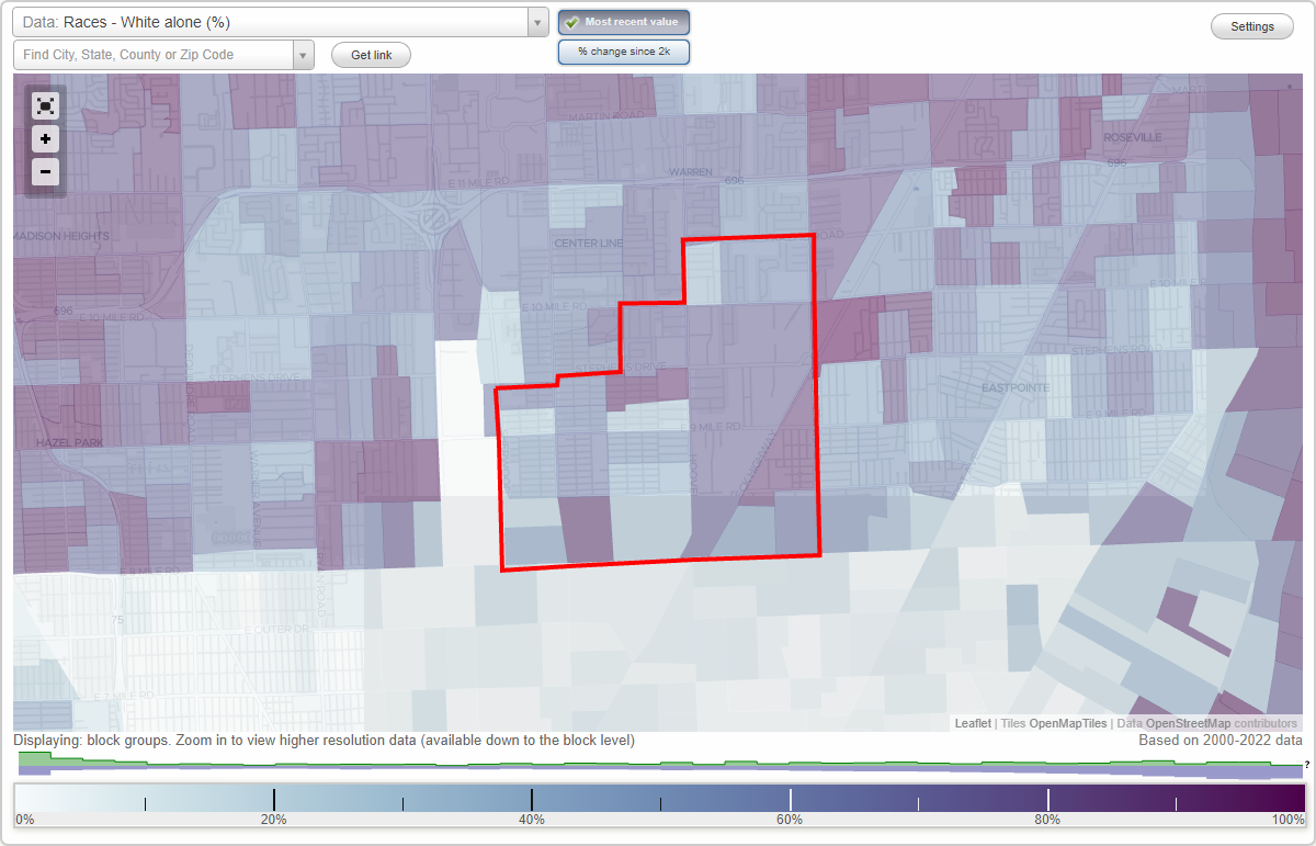
Area: 5.182 square miles
Population: 32,704
Population density:
| Van Dyke (Piper Van Dyke): | 6,311 people per square mile |
| Warren: | 3,999 people per square mile |

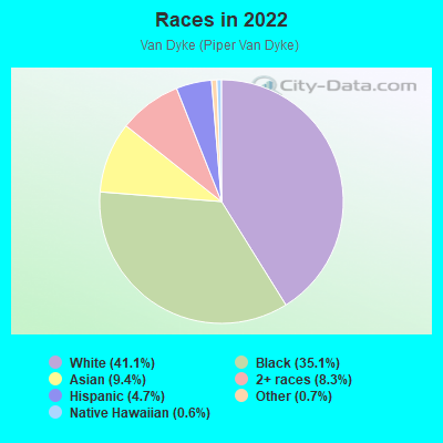
- 14,33241.1%White
- 12,25835.1%Black
- 3,2669.4%Asian
- 2,9078.3%Two or more races
- 1,6484.7%Hispanic or Latino
- 2390.7%Some other race
- 2170.6%Native Hawaiian and Other
Pacific Islander - 280.08%American Indian
Distribution of median household income
![Distribution of median household income]()
- 1,040Less than $10,000
- 1,375$10,000 to $19,999
- 1,862$20,000 to $29,999
- 1,378$30,000 to $39,999
- 1,665$40,000 to $49,999
- 1,495$50,000 to $59,999
- 1,291$60,000 to $74,999
- 1,674$75,000 to $99,999
- 753$100,000 to $124,999
- 906$125,000 to $149,999
- 1,234$150,000 to $199,999
- 511$200,000 or more

Distribution of owner-occupied house/condo value
![Distribution of owner-occupied house/condo value]()
- 2,588Less than $50,000
- 4,326$50,000 to $99,999
- 2,098$100,000 to $149,999
- 2,894$150,000 to $199,999
- 526$200,000 to $249,999
- 668$250,000 to $299,999
- 299$300,000 to $399,999
- 368$500,000 to $749,999
- 88$1,000,000 or more

Distribution of rent paid by renters
![Distribution of rent paid by renters]()
- 235Less than $100
- 1,177$100 to $199
- 817$200 to $299
- 1,527$300 to $399
- 1,429$400 to $499
- 1,764$500 to $599
- 896$600 to $699
- 1,517$700 to $799
- 1,864$800 to $899
- 1,475$900 to $999
- 1,029$1,000 to $1,249
- 400$1,250 to $1,499
- 170$1,500 to $1,999
- 519$2,000 or more

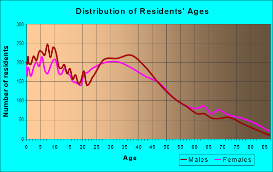
| Males: | 15,336 |
| Females: | 17,367 |
Males:
| This neighborhood: | 37.9 years |
| Whole city: | 36.9 years |
| This neighborhood: | 36.9 years |
| Whole city: | 40.0 years |
Average household size:
| Van Dyke (Piper Van Dyke): | 2.3 people |
| Warren: | 2.4 people |
Percentage of family households:
| Van Dyke (Piper Van Dyke): | 49.8% |
| Warren: | 42.0% |
| Here: | 30.6% |
| Warren: | 35.7% |
Percentage of married-couple families with children (among all households):
| Van Dyke (Piper Van Dyke): | 21.2% |
| Warren: | 27.8% |
Percentage of single-mother households (among all households):
| Van Dyke (Piper Van Dyke): | 17.1% |
| Warren: | 9.9% |
Percentage of never married males 15 years old and over:
Percentage of never married females 15 years old and over:
| Van Dyke (Piper Van Dyke): | 22.1% |
| Warren: | 20.1% |
Percentage of never married females 15 years old and over:
| Van Dyke (Piper Van Dyke): | 28.9% |
| city: | 18.7% |
Percentage of people that speak English not well or not at all:
| Van Dyke (Piper Van Dyke): | 1.0% |
| Warren: | 3.7% |
Percentage of people born in this state:
Percentage of people born in another U.S. state:
Percentage of native residents but born outside the U.S.:
Percentage of foreign born residents:
| Here: | 82.3% |
| Warren: | 72.3% |
Percentage of people born in another U.S. state:
| Van Dyke (Piper Van Dyke): | 12.5% |
| Warren: | 12.2% |
Percentage of native residents but born outside the U.S.:
| Here: | 0.5% |
| city: | 1.4% |
Percentage of foreign born residents:
| Here: | 5.0% |
| Warren: | 14.1% |
Owner-occupied
Renter-occupied

- Rooms in owner-occupied houses and condos in Van Dyke <
> - 01 room
- 8832 rooms
- 3443 rooms
- 7134 rooms
- 2,3325 rooms
- 1,7446 rooms
- 6267 rooms
- 1,2678 rooms
- 6729+ rooms
- Rooms in renter-occupied apartments in Van Dyke <
> - 1,2011 room
- 1,5982 rooms
- 9923 rooms
- 2,2944 rooms
- 1,4075 rooms
- 1,1456 rooms
- 4337 rooms
- 7898 rooms
- 5189+ rooms
Owner-occupied
Renter-occupied
- Bedrooms in owner-occupied houses and condos in Van Dyke <
> - 883no bedroom
- 3641 bedroom
- 1,2422 bedrooms
- 3,9853 bedrooms
- 1,7014 bedrooms
- 2045+ bedrooms
- Bedrooms in renter-occupied apartments in Van Dyke <
> - 1,340no bedroom
- 2,0771 bedroom
- 2,7942 bedrooms
- 1,8463 bedrooms
- 9704 bedrooms
- 5485+ bedrooms
Average number of cars or other vehicles available in houses/condos:
Average number of cars or other vehicles available in apartments:
| This neighborhood: | 1.9 |
| Warren: | 1.9 |
Average number of cars or other vehicles available in apartments:
| Here: | 1.1 |
| city: | 1.3 |
Percentage of units with a mortgage:
| Van Dyke (Piper Van Dyke): | 53.7% |
| Warren: | 59.8% |
Average estimated value of detached houses in 2022 (78.5% of all units):
| Van Dyke (Piper Van Dyke): | $101,567 |
| Warren: | $177,285 |
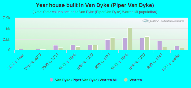
- Year house built in Van Dyke <
> - 2532020 or later
- 2932010 to 2019
- 1,1242000 to 2009
- 1,2471990 to 1999
- 1,2311980 to 1989
- 2,4771970 to 1979
- 2,8871960 to 1969
- 2,8471950 to 1959
- 2,1381940 to 1949
- 9251939 or earlier
City-data.com crime index for city in 2020 (higher means more crime):
| City: | 243.2 |
| U.S. average: | 219.5 |
Travel time to work (commute)
![Travel time to work (commute)]()
- 225Less than 5 minutes
- 6825 to 9 minutes
- 1,45510 to 14 minutes
- 2,03915 to 19 minutes
- 2,15520 to 24 minutes
- 85325 to 29 minutes
- 2,73130 to 34 minutes
- 39935 to 39 minutes
- 62640 to 44 minutes
- 1,32545 to 59 minutes
- 64260 to 89 minutes
- 43390 or more minutes

Means of transportation to work
![Means of transportation to work]()
- 75.0%11,591Drove a car alone
- 15.4%2,373Carpooled
- 7.3%1,126Bus
- 7.6%1,177Taxi
- 4.0%624Bicycle
- 1.0%160Walked
- 2.9%454Other means
- 5.7%884Worked at home

Time leaving home to go to work
![Time leaving home to go to work]()
- 1,36512:00 a.m. to 4:59 a.m.
- 5655:00 a.m. to 5:29 a.m.
- 1,1015:30 a.m. to 5:59 a.m.
- 7256:00 a.m. to 6:29 a.m.
- 6686:30 a.m. to 6:59 a.m.
- 1,0227:00 a.m. to 7:29 a.m.
- 1,2787:30 a.m. to 7:59 a.m.
- 1,7278:00 a.m. to 8:29 a.m.
- 4878:30 a.m. to 8:59 a.m.
- 7439:00 a.m. to 9:59 a.m.
- 64810:00 a.m. to 10:59 a.m.
- 46911:00 a.m. to 11:59 a.m.
- 1,41112:00 p.m. to 3:59 p.m.
- 1,2144:00 p.m. to 11:59 p.m.

Occupations of males:
- Percentage of males in management occupations (except farmers):
Here: 6.5% city: 5.6%
- Percentage of males in computer and mathematical occupations:
Here: 2.6% city: 2.7%
- Percentage of males in architecture and engineering occupations:
Here: 4.8% city: 4.9%
- Percentage of males in education, training, and library occupations:
Here: 3.2% city: 1.6%
- Percentage of males in healthcare practitioners and technical occupations:
Here: 1.1% city: 1.8%
- Percentage of males in service occupations:
Here: 15.4% city: 14.2%
- Percentage of males in sales and office occupations:
Here: 11.9% city: 14.7%
- Percentage of males in farming, fishing, and forestry occupations:
Here: 1.2% city: 0.1%
- Percentage of males in construction, extraction, and maintenance occupations:
Here: 10.3% city: 8.4%
- Percentage of males in production occupations:
Here: 22.5% city: 17.1%
- Percentage of males in transportation occupations:
Here: 4.5% city: 7.3%
- Percentage of males in material moving occupations:
Here: 13.4% city: 7.9%
Occupations of females:
- Percentage of females in management occupations (except farmers):
Here: 3.8% city: 6.2%
- Percentage of females in business and financial operations occupations:
Here: 5.0% city: 4.8%
- Percentage of females in architecture and engineering occupations:
Here: 4.5% city: 0.7%
- Percentage of females in education, training, and library occupations:
Here: 4.6% city: 5.8%
- Percentage of females in arts, design, entertainment, sports, and media occupations:
Here: 2.3% city: 1.1%
- Percentage of females in healthcare practitioners and technical occupations:
Here: 8.4% city: 9.2%
- Percentage of females in service occupations:
Here: 33.8% city: 23.6%
- Percentage of females in sales and office occupations:
Here: 27.6% city: 30.1%
- Percentage of females in production occupations:
Here: 7.5% city: 7.4%
- Percentage of females in material moving occupations:
Here: 4.8% city: 2.3%
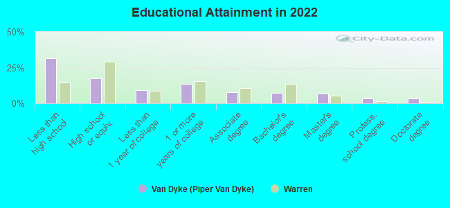
Education in this neighborhood (subdivision or community):
- Percentage of people 3 years and older in K-12 schools:
Van Dyke (Piper Van Dyke): 26.7% Warren: 15.2%
- Percentage of people 3 years and older in undergraduate colleges:
Van Dyke (Piper Van Dyke): 6.0% Warren: 5.2%
- Percentage of people 3 years and older in grad. or professional schools:
Van Dyke (Piper Van Dyke): 4.1% Warren: 0.7%
- Percentage of students K-12 enrolled in private schools:
Van Dyke (Piper Van Dyke): 32.1% Warren: 4.8%
Percentage of population below poverty level:
| Van Dyke (Piper Van Dyke): | 18.8% |
| Warren: | 13.7% |
Percentage of married-couple families with both working:
| Van Dyke (Piper Van Dyke): | 114.7% |
| Warren: | 49.3% |
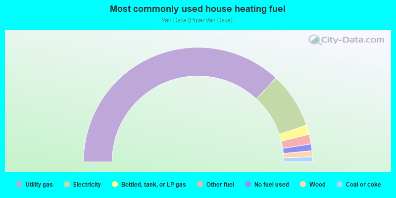
- 73.9%Utility gas
- 15.8%Electricity
- 2.7%Bottled, tank, or LP gas
- 2.7%Other fuel
- 1.9%No fuel used
- 1.7%Wood
- 1.4%Coal or coke
Highways in this neighborhood:
E 8 Mile Rd (State Hwy 102, 8 Mile Rd)
Length: 3.38 miles
Direction: E-W
Address range: 6682 to 13599
Direction: E-W
Address range: 6682 to 13599
State Hwy 97 (Groesbeck Hwy)
Length: 1.88 miles
Directions: E-W, N-S, SW-NE
Address range: 20700 to 23881
Directions: E-W, N-S, SW-NE
Address range: 20700 to 23881
Earl Memorial Hwy (Van Dyke Ave, State Hwy 53)
Length: 1.42 miles
Direction: N-S
Address range: 20700 to 23673
Direction: N-S
Address range: 20700 to 23673
Roads and streets:
Toepfer Rd
Length: 3.14 miles
Directions: E-W, N-S
Address range: 6700 to 13599
Directions: E-W, N-S
Address range: 6700 to 13599
Hoover Rd
Length: 2.51 miles
Directions: N-S, SW-NE
Address range: 20700 to 26064
Directions: N-S, SW-NE
Address range: 20700 to 26064
Schoenherr Rd
Length: 2.50 miles
Direction: N-S
Address range: 20700 to 25999
Direction: N-S
Address range: 20700 to 25999
Republic Ave
Length: 2.46 miles
Direction: E-W
Address range: 6700 to 12399
Direction: E-W
Address range: 6700 to 12399
Timken Ave
Length: 2.23 miles
Direction: E-W
Address range: 7200 to 12699
Direction: E-W
Address range: 7200 to 12699
Stephens Rd (Stephens Dr)
Length: 2.04 miles
Directions: E-W, SW-NE
Address range: 11000 to 13599
Directions: E-W, SW-NE
Address range: 11000 to 13599
Continental Ave
Length: 2.03 miles
Direction: E-W
Address range: 6700 to 11599
Direction: E-W
Address range: 6700 to 11599
E 10 Mile Rd
Length: 2.02 miles
Direction: E-W
Address range: 11000 to 13599
Direction: E-W
Address range: 11000 to 13599
Prospect Ave
Length: 2.02 miles
Direction: E-W
Address range: 6700 to 13599
Direction: E-W
Address range: 6700 to 13599
Maxwell Ave
Length: 1.94 miles
Direction: E-W
Address range: 6700 to 11599
Direction: E-W
Address range: 6700 to 11599
Dodge Ave
Length: 1.84 miles
Direction: E-W
Address range: 6700 to 11599
Direction: E-W
Address range: 6700 to 11599
Cadillac Ave
Length: 1.84 miles
Direction: E-W
Address range: 6700 to 11599
Direction: E-W
Address range: 6700 to 11599
Lozier Ave
Length: 1.71 miles
Direction: E-W
Address range: 6700 to 11399
Direction: E-W
Address range: 6700 to 11399
Studebaker Ave
Length: 1.70 miles
Direction: E-W
Address range: 6700 to 11399
Direction: E-W
Address range: 6700 to 11399
Paige Ave
Length: 1.69 miles
Direction: E-W
Address range: 6700 to 11399
Direction: E-W
Address range: 6700 to 11399
9 Mile Rd
Length: 1.69 miles
Direction: E-W
Address range: 6700 to 11357
Direction: E-W
Address range: 6700 to 11357
E 9 Mile Rd
Length: 1.68 miles
Direction: E-W
Address range: 11358 to 13599
Direction: E-W
Address range: 11358 to 13599
Fisher Ave
Length: 1.66 miles
Direction: E-W
Address range: 6700 to 11599
Direction: E-W
Address range: 6700 to 11599
Hupp Ave
Length: 1.66 miles
Direction: E-W
Address range: 7000 to 15999
Direction: E-W
Address range: 7000 to 15999
Chalmers Ave
Length: 1.65 miles
Direction: E-W
Address range: 6700 to 11399
Direction: E-W
Address range: 6700 to 11399
Rivard Ave
Length: 1.52 miles
Direction: E-W
Address range: 6700 to 11599
Direction: E-W
Address range: 6700 to 11599
Jackson Ave
Length: 1.52 miles
Direction: E-W
Address range: 6700 to 11599
Direction: E-W
Address range: 6700 to 11599
Sherman Ave
Length: 1.52 miles
Direction: E-W
Address range: 8400 to 13599
Direction: E-W
Address range: 8400 to 13599
Ford Ave
Length: 1.50 miles
Direction: E-W
Address range: 6700 to 11399
Direction: E-W
Address range: 6700 to 11399
Lorraine Ave
Length: 1.50 miles
Direction: N-S
Address range: 21700 to 24999
Direction: N-S
Address range: 21700 to 24999
Wagner Ave
Length: 1.50 miles
Directions: N-S, SE-NW
Address range: 23000 to 25999
Directions: N-S, SE-NW
Address range: 23000 to 25999
Hudson Ave
Length: 1.50 miles
Direction: E-W
Address range: 7000 to 11399
Direction: E-W
Address range: 7000 to 11399
Federal Ave
Length: 1.47 miles
Direction: N-S
Address range: 20700 to 23799
Direction: N-S
Address range: 20700 to 23799
Sherwood Ave
Length: 1.40 miles
Direction: N-S
Address range: 20700 to 23399
Direction: N-S
Address range: 20700 to 23399
Packard Ave
Length: 1.40 miles
Direction: E-W
Address range: 7000 to 11399
Direction: E-W
Address range: 7000 to 11399
Frazho Rd
Length: 1.34 miles
Directions: E-W, SW-NE
Address range: 11600 to 13599
Directions: E-W, SW-NE
Address range: 11600 to 13599
Memphis Ave
Length: 1.27 miles
Directions: N-S, SW-NE
Address range: 20700 to 23499
Directions: N-S, SW-NE
Address range: 20700 to 23499
Campbell Ave
Length: 1.25 miles
Directions: N-S, SE-NW
Address range: 21700 to 24999
Directions: N-S, SE-NW
Address range: 21700 to 24999
Marmon Ave
Length: 1.25 miles
Directions: N-S, SE-NW, SW-NE
Address range: 21700 to 24499
Directions: N-S, SE-NW, SW-NE
Address range: 21700 to 24499
Westminster Ave
Length: 1.15 miles
Direction: E-W
Address range: 6700 to 8599
Direction: E-W
Address range: 6700 to 8599
Meadow Ave
Length: 1.15 miles
Direction: E-W
Address range: 6700 to 8599
Direction: E-W
Address range: 6700 to 8599
Orchard Ave
Length: 1.14 miles
Direction: E-W
Address range: 6700 to 8599
Direction: E-W
Address range: 6700 to 8599
Jewett Ave
Length: 1.11 miles
Direction: E-W
Address range: 8000 to 11399
Direction: E-W
Address range: 8000 to 11399
Essex Ave
Length: 1.11 miles
Direction: E-W
Address range: 8000 to 11399
Direction: E-W
Address range: 8000 to 11399
Peters Ave
Length: 1.04 miles
Direction: N-S
Address range: 21400 to 23639
Direction: N-S
Address range: 21400 to 23639
Automobile Blvd
Length: 0.94 miles
Direction: N-S
Address range: 21700 to 23799
Direction: N-S
Address range: 21700 to 23799
Mac Arthur Blvd
Length: 0.92 miles
Direction: N-S
Address range: 20700 to 22999
Direction: N-S
Address range: 20700 to 22999
Chapp Ave
Length: 0.90 miles
Direction: E-W
Address range: 8200 to 11399
Direction: E-W
Address range: 8200 to 11399
Couwlier Ave
Length: 0.89 miles
Directions: E-W, SW-NE
Address range: 12300 to 13599
Directions: E-W, SW-NE
Address range: 12300 to 13599
Sidonie Ave
Length: 0.84 miles
Direction: E-W
Address range: 12300 to 13599
Direction: E-W
Address range: 12300 to 13599
Amber Ave
Length: 0.78 miles
Direction: N-S
Address range: 23000 to 23999
Direction: N-S
Address range: 23000 to 23999
Sharrow Ave
Length: 0.74 miles
Direction: N-S
Address range: 21200 to 22999
Direction: N-S
Address range: 21200 to 22999
Coleen Ave
Length: 0.74 miles
Directions: E-W, N-S, SW-NE
Address range: 12400 to 13599
Directions: E-W, N-S, SW-NE
Address range: 12400 to 13599
Vernon Ave
Length: 0.72 miles
Direction: E-W
Address range: 12200 to 13599
Direction: E-W
Address range: 12200 to 13599
Kaltz Ave
Length: 0.70 miles
Direction: E-W
Address range: 8788 to 11599
Direction: E-W
Address range: 8788 to 11599
Georgiana Ave
Length: 0.66 miles
Direction: E-W
Address range: 12300 to 13599
Direction: E-W
Address range: 12300 to 13599
Sarsfield Ave
Length: 0.66 miles
Direction: E-W
Address range: 12300 to 13599
Direction: E-W
Address range: 12300 to 13599
Yacht Ave
Length: 0.63 miles
Direction: E-W
Address range: 6700 to 7999
Direction: E-W
Address range: 6700 to 7999
Fairfield Ave
Length: 0.61 miles
Directions: E-W, N-S, SE-NW, SW-NE
Address range: 20700 to 22399
Directions: E-W, N-S, SE-NW, SW-NE
Address range: 20700 to 22399
Fisk Ave
Length: 0.58 miles
Direction: E-W
Address range: 12800 to 13599
Direction: E-W
Address range: 12800 to 13599
Helle Ave
Length: 0.58 miles
Directions: E-W, N-S, SW-NE
Address range: 20700 to 27699
Directions: E-W, N-S, SW-NE
Address range: 20700 to 27699
Mac Arthur Ave
Length: 0.54 miles
Direction: N-S
Address range: 21001 to 23799
Direction: N-S
Address range: 21001 to 23799
Engleman Rd
Length: 0.54 miles
Direction: E-W
Address range: 11600 to 12299
Direction: E-W
Address range: 11600 to 12299
Ascension Ave
Length: 0.52 miles
Direction: N-S
Address range: 20700 to 21699
Direction: N-S
Address range: 20700 to 21699
Mullin Ave
Length: 0.52 miles
Direction: N-S
Address range: 20700 to 21699
Direction: N-S
Address range: 20700 to 21699
Marie Ave
Length: 0.51 miles
Directions: N-S, SE-NW
Address range: 20700 to 21699
Directions: N-S, SE-NW
Address range: 20700 to 21699
Gibson Dr
Length: 0.51 miles
Directions: N-S, SW-NE
Address range: 24000 to 24999
Directions: N-S, SW-NE
Address range: 24000 to 24999
Nagel St
Length: 0.51 miles
Direction: N-S
Address range: 22500 to 22999
Direction: N-S
Address range: 22500 to 22999
Waltham Rd
Length: 0.51 miles
Direction: N-S
Address range: 20700 to 21699
Direction: N-S
Address range: 20700 to 21699
Marilyn Ave
Length: 0.50 miles
Direction: N-S
Address range: 25000 to 25999
Direction: N-S
Address range: 25000 to 25999
Blackstone Ave
Length: 0.50 miles
Direction: N-S
Address range: 23000 to 23999
Direction: N-S
Address range: 23000 to 23999
Tallman Ave
Length: 0.50 miles
Direction: N-S
Address range: 24000 to 24999
Direction: N-S
Address range: 24000 to 24999
Forterra Dr
Length: 0.49 miles
Directions: E-W, N-S, SW-NE
Address range: 24000 to 24999
Directions: E-W, N-S, SW-NE
Address range: 24000 to 24999
Harold St
Length: 0.49 miles
Direction: E-W
Address range: 11600 to 13599
Direction: E-W
Address range: 11600 to 13599
Rubin Rd
Length: 0.48 miles
Direction: N-S
Address range: 25000 to 25819
Direction: N-S
Address range: 25000 to 25819
Ready Ave
Length: 0.47 miles
Directions: E-W, N-S, SE-NW
Address range: 7000 to 7999
Directions: E-W, N-S, SE-NW
Address range: 7000 to 7999
Heussner Ave
Length: 0.47 miles
Direction: N-S
Address range: 21700 to 22999
Direction: N-S
Address range: 21700 to 22999
Griffin Ave
Length: 0.43 miles
Directions: E-W, N-S, SW-NE
Address range: 20700 to 21299
Directions: E-W, N-S, SW-NE
Address range: 20700 to 21299
Saint Andrews Ave
Length: 0.41 miles
Direction: E-W
Address range: 13000 to 13599
Direction: E-W
Address range: 13000 to 13599
Belmont Ave
Length: 0.41 miles
Direction: E-W
Address range: 11600 to 12299
Direction: E-W
Address range: 11600 to 12299
Roan Ave
Length: 0.38 miles
Direction: N-S
Address range: 25000 to 25699
Direction: N-S
Address range: 25000 to 25699
Palomino Ave
Length: 0.36 miles
Direction: N-S
Address range: 25000 to 25699
Direction: N-S
Address range: 25000 to 25699
Regency Park Dr
Length: 0.36 miles
Directions: E-W, N-S, SE-NW, SW-NE
Address range: 23350 to 23895
Directions: E-W, N-S, SE-NW, SW-NE
Address range: 23350 to 23895
Winfield Ave
Length: 0.36 miles
Direction: N-S
Address range: 20700 to 21449
Direction: N-S
Address range: 20700 to 21449
Garson Ave
Length: 0.33 miles
Direction: E-W
Address range: 13000 to 13699
Direction: E-W
Address range: 13000 to 13699
Avondale Ave
Length: 0.33 miles
Direction: E-W
Address range: 11600 to 12199
Direction: E-W
Address range: 11600 to 12199
Conners Ave
Length: 0.33 miles
Direction: SE-NW
Address range: 21400 to 21899
Direction: SE-NW
Address range: 21400 to 21899
Antoinette Ave
Length: 0.32 miles
Direction: N-S
Address range: 24200 to 24999
Direction: N-S
Address range: 24200 to 24999
Hillock Ave
Length: 0.31 miles
Direction: N-S
Address range: 21900 to 22999
Direction: N-S
Address range: 21900 to 22999
Zagaiski Ave
Length: 0.30 miles
Direction: E-W
Address range: 13231 to 13598
Direction: E-W
Address range: 13231 to 13598
Theut Ave
Length: 0.30 miles
Direction: E-W
Address range: 7200 to 7999
Direction: E-W
Address range: 7200 to 7999
Highland Dr
Length: 0.30 miles
Direction: E-W
Address range: 11600 to 11999
Direction: E-W
Address range: 11600 to 11999
Hovey St
Length: 0.29 miles
Direction: E-W
Address range: 11600 to 11999
Direction: E-W
Address range: 11600 to 11999
Julius Ave
Length: 0.27 miles
Direction: E-W
Address range: 13100 to 13599
Direction: E-W
Address range: 13100 to 13599
Young Ave
Length: 0.27 miles
Direction: E-W
Address range: 11300 to 11599
Direction: E-W
Address range: 11300 to 11599
Metter Ave
Length: 0.26 miles
Direction: E-W
Address range: 11300 to 11599
Direction: E-W
Address range: 11300 to 11599
Superior Ave
Length: 0.26 miles
Directions: E-W, N-S, SE-NW, SW-NE
Address range: 11000 to 11399
Directions: E-W, N-S, SE-NW, SW-NE
Address range: 11000 to 11399
Commerce St
Length: 0.26 miles
Direction: E-W
Address range: 11600 to 11999
Direction: E-W
Address range: 11600 to 11999
Charlotte Ave
Length: 0.25 miles
Direction: E-W
Address range: 13300 to 13599
Direction: E-W
Address range: 13300 to 13599
Cloie Dr
Length: 0.25 miles
Directions: N-S, SE-NW
Address range: 25400 to 25899
Directions: N-S, SE-NW
Address range: 25400 to 25899
Schmeman Ave
Length: 0.25 miles
Direction: N-S
Address range: 21700 to 22599
Direction: N-S
Address range: 21700 to 22599
Marigold Ave
Length: 0.25 miles
Direction: N-S
Address range: 24500 to 24999
Direction: N-S
Address range: 24500 to 24999
Hesse Ave
Length: 0.25 miles
Direction: N-S
Address range: 24500 to 24999
Direction: N-S
Address range: 24500 to 24999
Oaklane St
Length: 0.25 miles
Direction: N-S
Address range: 22400 to 22999
Direction: N-S
Address range: 22400 to 22999
Ocalla Dr
Length: 0.24 miles
Direction: E-W
Address range: 11000 to 11299
Direction: E-W
Address range: 11000 to 11299
Edgemont Ave
Length: 0.24 miles
Direction: E-W
Address range: 11000 to 11299
Direction: E-W
Address range: 11000 to 11299
Rayburn Dr
Length: 0.22 miles
Direction: N-S
Address range: 25000 to 25299
Direction: N-S
Address range: 25000 to 25299
Lawrence Ave
Length: 0.22 miles
Direction: N-S
Direction: N-S
Stephens Rd
Length: 0.21 miles
Direction: E-W
Direction: E-W
Edom Ave
Length: 0.21 miles
Direction: N-S
Address range: 20800 to 21699
Direction: N-S
Address range: 20800 to 21699
Brainwood Ave
Length: 0.20 miles
Direction: E-W
Address range: 13200 to 13599
Direction: E-W
Address range: 13200 to 13599
Brainbridge Ave
Length: 0.19 miles
Direction: E-W
Address range: 13200 to 13599
Direction: E-W
Address range: 13200 to 13599
Rosemarie Ave
Length: 0.17 miles
Directions: N-S, SE-NW, SW-NE
Address range: 24100 to 24399
Directions: N-S, SE-NW, SW-NE
Address range: 24100 to 24399
Industrial Hwy
Length: 0.16 miles
Direction: SW-NE
Address range: 24000 to 24999
Direction: SW-NE
Address range: 24000 to 24999
Unity Dr
Length: 0.16 miles
Direction: E-W
Address range: 11000 to 11299
Direction: E-W
Address range: 11000 to 11299
Wahl St
Length: 0.16 miles
Direction: N-S
Address range: 24000 to 24399
Direction: N-S
Address range: 24000 to 24399
State Park St
Length: 0.14 miles
Directions: E-W, SE-NW, SW-NE
Address range: 12100 to 12499
Directions: E-W, SE-NW, SW-NE
Address range: 12100 to 12499
Crimson Ct
Length: 0.14 miles
Direction: N-S
Address range: 25600 to 25899
Direction: N-S
Address range: 25600 to 25899
Globe Ave
Length: 0.14 miles
Direction: N-S
Address range: 22700 to 22999
Direction: N-S
Address range: 22700 to 22999
Becker Ave
Length: 0.13 miles
Direction: N-S
Address range: 22700 to 22999
Direction: N-S
Address range: 22700 to 22999
Victory Ave
Length: 0.13 miles
Directions: E-W, N-S, SE-NW
Address range: 7000 to 7299
Directions: E-W, N-S, SE-NW
Address range: 7000 to 7299
Louisiana Ave
Length: 0.13 miles
Direction: E-W
Address range: 12100 to 12499
Direction: E-W
Address range: 12100 to 12499
Gibson Ave
Length: 0.11 miles
Direction: N-S
Address range: 23200 to 23499
Direction: N-S
Address range: 23200 to 23499
Park Cir
Length: 0.11 miles
Directions: E-W, N-S, SE-NW, SW-NE
Address range: 13438 to 13499
Directions: E-W, N-S, SE-NW, SW-NE
Address range: 13438 to 13499
Afton Dr
Length: 0.08 miles
Direction: E-W
Address range: 12300 to 12499
Direction: E-W
Address range: 12300 to 12499
Mruk Ave
Length: 0.08 miles
Directions: E-W, SE-NW, SW-NE
Address range: 12300 to 12499
Directions: E-W, SE-NW, SW-NE
Address range: 12300 to 12499
Coolidge Ave
Length: 0.08 miles
Direction: E-W
Address range: 11340 to 11364
Direction: E-W
Address range: 11340 to 11364
Konczal Ave
Length: 0.07 miles
Direction: E-W
Address range: 11338 to 11369
Direction: E-W
Address range: 11338 to 11369
Schultz St
Length: 0.06 miles
Direction: N-S
Address range: 23800 to 23999
Direction: N-S
Address range: 23800 to 23999
Asphalt Dr
Length: 0.04 miles
Directions: E-W, N-S, SE-NW, SW-NE
Directions: E-W, N-S, SE-NW, SW-NE
Motor City Trailer Park
Length: 0.04 miles
Direction: E-W
Direction: E-W
Sterling St
Length: 0.03 miles
Direction: E-W
Direction: E-W
Railroad features:
Conrail RR (Csx RR & Norfolk Southern Rlwy)
Length: 5.96 miles
Directions: E-W, N-S, SE-NW, SW-NE
Directions: E-W, N-S, SE-NW, SW-NE
Csx RR & Norfolk Southern Rlwy
Length: 0.68 miles
Directions: N-S, SE-NW, SW-NE
Directions: N-S, SE-NW, SW-NE
Other features:
Harrington Drn
Length: 0.55 miles
Direction: SW-NE
Direction: SW-NE
Highways in this neighborhood:
State Hwy 102 (E 8 Mile Rd, 8 Mile Rd)
Length: 3.38 miles
Direction: E-W
Address range: 6682 to 13599
Direction: E-W
Address range: 6682 to 13599
Roads and streets:
Bramford St
Length: 0.01 miles
Direction: N-S
Address range: 20513 to 20551
Direction: N-S
Address range: 20513 to 20551