Riverton neighborhood in Portland, Maine (ME), 04103 detailed profile
Settings
X

Business Search - 14 Million verified businesses
Area: 3.691 square miles
Population: 4,016
Population density:
| Riverton: | 1,088 people per square mile |
| Portland: | 3,226 people per square mile |

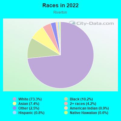
- 3,07073.3%White
- 42810.2%Black
- 3117.4%Asian
- 1784.2%Two or more races
- 1052.5%Some other race
- 390.9%American Indian
- 350.8%Hispanic or Latino
- 240.6%Native Hawaiian and Other
Pacific Islander
Median household income in 2022:
| Riverton: | $89,970 |
| Portland: | $69,046 |
Distribution of median household income
![Distribution of median household income]()
- 193Less than $10,000
- 103$10,000 to $19,999
- 362$20,000 to $29,999
- 333$30,000 to $39,999
- 74$40,000 to $49,999
- 170$50,000 to $59,999
- 195$60,000 to $74,999
- 104$75,000 to $99,999
- 192$100,000 to $124,999
- 137$125,000 to $149,999
- 623$150,000 to $199,999
- 263$200,000 or more

Distribution of owner-occupied house/condo value
![Distribution of owner-occupied house/condo value]()
- 469Less than $50,000
- 253$50,000 to $99,999
- 32$100,000 to $149,999
- 179$150,000 to $199,999
- 236$200,000 to $249,999
- 353$250,000 to $299,999
- 284$300,000 to $399,999
- 258$400,000 to $499,999
- 83$500,000 to $749,999
- 18$750,000 to $999,999
- 723$1,000,000 or more

Distribution of rent paid by renters
![Distribution of rent paid by renters]()
- 30$100 to $199
- 197$200 to $299
- 303$300 to $399
- 91$400 to $499
- 498$500 to $599
- 107$600 to $699
- 88$700 to $799
- 256$800 to $899
- 444$900 to $999
- 45$1,000 to $1,249
- 93$1,250 to $1,499
- 62$1,500 to $1,999
- 66$2,000 or more

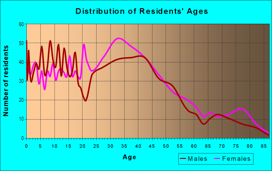
| Males: | 1,944 |
| Females: | 2,071 |
Males:
| This neighborhood: | 38.9 years |
| Whole city: | 36.3 years |
| This neighborhood: | 47.6 years |
| Whole city: | 38.4 years |
Average household size:
| Riverton: | 2.3 people |
| Portland: | 1.9 people |
Percentage of family households:
| Riverton: | 37.8% |
| Portland: | 30.1% |
| Here: | 47.4% |
| Portland: | 30.1% |
Percentage of married-couple families with children (among all households):
| Riverton: | 27.1% |
| Portland: | 37.5% |
Percentage of single-mother households (among all households):
| Riverton: | 12.3% |
| Portland: | 10.8% |
Percentage of never married males 15 years old and over:
Percentage of never married females 15 years old and over:
| Riverton: | 16.6% |
| Portland: | 26.6% |
Percentage of never married females 15 years old and over:
| Riverton: | 19.4% |
| city: | 23.3% |
Percentage of people that speak English not well or not at all:
| Riverton: | 5.0% |
| Portland: | 2.5% |
Percentage of people born in this state:
Percentage of people born in another U.S. state:
Percentage of native residents but born outside the U.S.:
Percentage of foreign born residents:
| Here: | 59.4% |
| Portland: | 43.1% |
Percentage of people born in another U.S. state:
| Riverton: | 23.5% |
| Portland: | 43.4% |
Percentage of native residents but born outside the U.S.:
| Here: | 1.4% |
| city: | 1.0% |
Percentage of foreign born residents:
| Here: | 15.7% |
| Portland: | 12.6% |
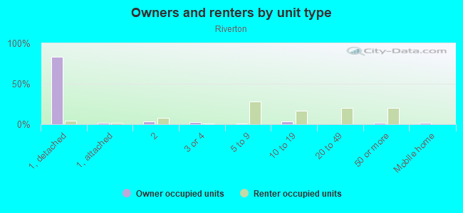
Owner-occupied
Renter-occupied

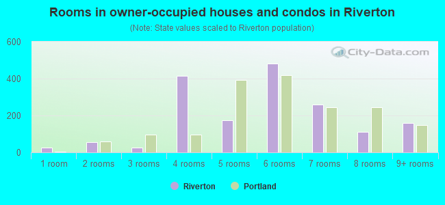
- Rooms in owner-occupied houses and condos in Riverton
- 261 room
- 542 rooms
- 253 rooms
- 4144 rooms
- 1745 rooms
- 4836 rooms
- 2617 rooms
- 1118 rooms
- 1619+ rooms
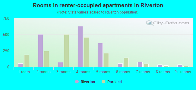
- Rooms in renter-occupied apartments in Riverton
- 541 room
- 5052 rooms
- 743 rooms
- 6314 rooms
- 3715 rooms
- 576 rooms
- 797 rooms
- 368 rooms
- 359+ rooms
Owner-occupied
Renter-occupied
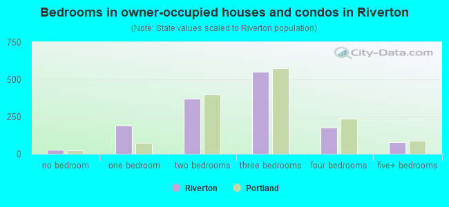
- Bedrooms in owner-occupied houses and condos in Riverton
- 26no bedroom
- 1891 bedroom
- 3702 bedrooms
- 5503 bedrooms
- 1754 bedrooms
- 795+ bedrooms

- Bedrooms in renter-occupied apartments in Riverton
- 16no bedroom
- 481 bedroom
- 1672 bedrooms
- 443 bedrooms
- 444 bedrooms
- 05+ bedrooms
Average number of cars or other vehicles available in houses/condos:
Average number of cars or other vehicles available in apartments:
| This neighborhood: | 1.8 |
| Portland: | 1.7 |
Average number of cars or other vehicles available in apartments:
| Here: | 1.4 |
| city: | 1.1 |
Percentage of units with a mortgage:
| Riverton: | 61.8% |
| Portland: | 66.6% |
Housing prices:
- Average estimated value of detached houses in 2022 (82.2% of all units):
Riverton: $363,431 Portland: $481,980
- Average estimated value of townhouses or other attached units in 2022 (3.2% of all units):
This neighborhood: $24,589 city: $387,050
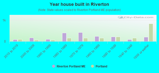
- Year house built in Riverton
- 02020 or later
- 872010 to 2019
- 1692000 to 2009
- 1031990 to 1999
- 4061980 to 1989
- 4321970 to 1979
- 2471960 to 1969
- 2181950 to 1959
- 971940 to 1949
- 2061939 or earlier
City-data.com crime index for city in 2020 (higher means more crime):
| City: | 146.3 |
| U.S. average: | 219.5 |
Travel time to work (commute)
![Travel time to work (commute)]()
- 17Less than 5 minutes
- 2585 to 9 minutes
- 27710 to 14 minutes
- 41415 to 19 minutes
- 43820 to 24 minutes
- 20025 to 29 minutes
- 17630 to 34 minutes
- 5635 to 39 minutes
- 1840 to 44 minutes
- 15445 to 59 minutes
- 5860 to 89 minutes
- 9490 or more minutes

Means of transportation to work
![Means of transportation to work]()
- 87.9%1,793Drove a car alone
- 5.1%105Carpooled
- 0.1%2Bus
- 0.7%15Ferryboat
- 1.4%29Taxi
- 2.6%54Motorcycle
- 3.5%71Bicycle
- 4.0%82Walked
- 2.0%40Other means
- 25.4%518Worked at home

Time leaving home to go to work
![Time leaving home to go to work]()
- 14212:00 a.m. to 4:59 a.m.
- 275:00 a.m. to 5:29 a.m.
- 305:30 a.m. to 5:59 a.m.
- 936:00 a.m. to 6:29 a.m.
- 2146:30 a.m. to 6:59 a.m.
- 4117:00 a.m. to 7:29 a.m.
- 2317:30 a.m. to 7:59 a.m.
- 3008:00 a.m. to 8:29 a.m.
- 1248:30 a.m. to 8:59 a.m.
- 539:00 a.m. to 9:59 a.m.
- 7110:00 a.m. to 10:59 a.m.
- 9311:00 a.m. to 11:59 a.m.
- 13612:00 p.m. to 3:59 p.m.
- 1744:00 p.m. to 11:59 p.m.

Occupations of males:
- Percentage of males in management occupations (except farmers):
Here: 23.0% city: 11.4%
- Percentage of males in business and financial operations occupations:
Here: 4.1% city: 8.3%
- Percentage of males in computer and mathematical occupations:
Here: 16.3% city: 7.1%
- Percentage of males in architecture and engineering occupations:
Here: 4.0% city: 2.8%
- Percentage of males in education, training, and library occupations:
Here: 2.1% city: 5.4%
- Percentage of males in healthcare practitioners and technical occupations:
Here: 2.8% city: 4.2%
- Percentage of males in service occupations:
Here: 7.1% city: 12.5%
- Percentage of males in sales and office occupations:
Here: 14.3% city: 17.0%
- Percentage of males in construction, extraction, and maintenance occupations:
Here: 3.8% city: 5.0%
- Percentage of males in production occupations:
Here: 15.6% city: 6.9%
- Percentage of males in transportation occupations:
Here: 4.3% city: 4.0%
- Percentage of males in material moving occupations:
Here: 1.6% city: 2.9%
Occupations of females:
- Percentage of females in management occupations (except farmers):
Here: 17.5% city: 14.5%
- Percentage of females in business and financial operations occupations:
Here: 4.2% city: 7.5%
- Percentage of females in community and social services occupations:
Here: 3.5% city: 4.4%
- Percentage of females in education, training, and library occupations:
Here: 10.5% city: 11.1%
- Percentage of females in healthcare practitioners and technical occupations:
Here: 9.8% city: 10.3%
- Percentage of females in service occupations:
Here: 11.1% city: 17.5%
- Percentage of females in sales and office occupations:
Here: 34.0% city: 19.7%
- Percentage of females in production occupations:
Here: 8.6% city: 1.9%
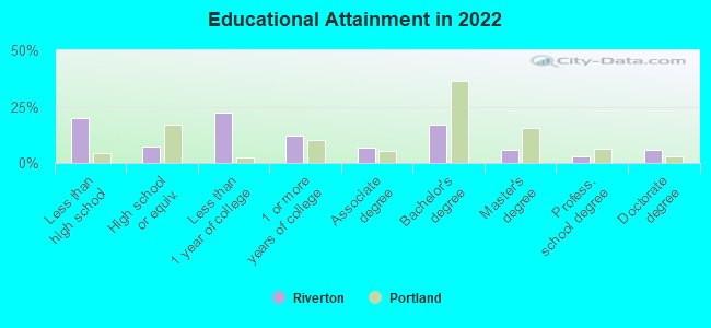
Education in this neighborhood (subdivision or community):
- Percentage of people 3 years and older in K-12 schools:
Riverton: 30.4% Portland: 9.8%
- Percentage of people 3 years and older in undergraduate colleges:
Riverton: 6.5% Portland: 2.3%
- Percentage of people 3 years and older in grad. or professional schools:
Riverton: 5.0% Portland: 3.7%
- Percentage of students K-12 enrolled in private schools:
Riverton: 39.3% Portland: 18.2%
Percentage of population below poverty level:
| Riverton: | 8.0% |
| Portland: | 12.5% |
Median year owner moved in (as recorded in 2022):
| Riverton: | 2007 |
| Portland: | 2011 |
Percentage of married-couple families with both working:
| Riverton: | 88.2% |
| Portland: | 79.3% |
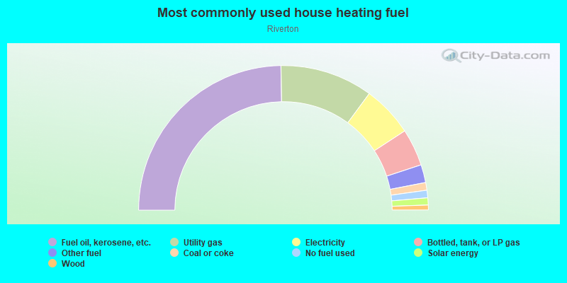
- 49.4%Fuel oil, kerosene, etc.
- 20.7%Utility gas
- 11.4%Electricity
- 8.3%Bottled, tank, or LP gas
- 4.0%Other fuel
- 1.7%Coal or coke
- 1.7%No fuel used
- 1.6%Solar energy
- 1.1%Wood
Limited-access highways (interstate or state) in this neighborhood:
I- 95
Length: 6.75 miles
Directions: E-W, N-S, SE-NW, SW-NE
Directions: E-W, N-S, SE-NW, SW-NE
Highways in this neighborhood:
US Hwy 302 (Forest Ave)
Length: 2.46 miles
Directions: E-W, SE-NW
Address range: 1185 to 2013
Directions: E-W, SE-NW
Address range: 1185 to 2013
Allen Ave (State Rte 100)
Length: 0.10 miles
Directions: N-S, SW-NE
Address range: 9 to 16
Directions: N-S, SW-NE
Address range: 9 to 16
Roads and streets:
Riverside St
Length: 2.92 miles
Directions: E-W, N-S, SE-NW, SW-NE
Address range: 272 to 1400
Directions: E-W, N-S, SE-NW, SW-NE
Address range: 272 to 1400
Warren Ave
Length: 2.44 miles
Directions: E-W, N-S, SW-NE
Address range: 101 to 753
Directions: E-W, N-S, SW-NE
Address range: 101 to 753
Riverside Industrial Pkwy
Length: 1.40 miles
Directions: N-S, SW-NE
Address range: 1 to 544
Directions: N-S, SW-NE
Address range: 1 to 544
Lane Ave
Length: 0.78 miles
Directions: E-W, SE-NW, SW-NE
Address range: 1 to 326
Directions: E-W, SE-NW, SW-NE
Address range: 1 to 326
Stevens Ave
Length: 0.68 miles
Directions: N-S, SW-NE
Address range: 556 to 875
Directions: N-S, SW-NE
Address range: 556 to 875
Industrial Way
Length: 0.64 miles
Directions: E-W, N-S, SW-NE
Address range: 1 to 299
Directions: E-W, N-S, SW-NE
Address range: 1 to 299
Hicks St
Length: 0.63 miles
Directions: E-W, N-S, SW-NE
Address range: 1 to 233
Directions: E-W, N-S, SW-NE
Address range: 1 to 233
Lexington Ave
Length: 0.55 miles
Direction: SE-NW
Address range: 21 to 210
Direction: SE-NW
Address range: 21 to 210
Dorothy St
Length: 0.54 miles
Directions: E-W, N-S, SE-NW, SW-NE
Address range: 1 to 199
Directions: E-W, N-S, SE-NW, SW-NE
Address range: 1 to 199
Broadway
Length: 0.49 miles
Direction: SE-NW
Address range: 21 to 209
Direction: SE-NW
Address range: 21 to 209
Harris Ave
Length: 0.46 miles
Direction: SW-NE
Address range: 1 to 179
Direction: SW-NE
Address range: 1 to 179
Belfort St
Length: 0.45 miles
Direction: SW-NE
Address range: 1 to 179
Direction: SW-NE
Address range: 1 to 179
Newton St
Length: 0.44 miles
Direction: SW-NE
Address range: 1 to 199
Direction: SW-NE
Address range: 1 to 199
Bishop St
Length: 0.41 miles
Direction: E-W
Address range: 1 to 126
Direction: E-W
Address range: 1 to 126
Tucker Ave
Length: 0.38 miles
Directions: N-S, SW-NE
Address range: 1 to 199
Directions: N-S, SW-NE
Address range: 1 to 199
W Commonwealth Dr
Length: 0.37 miles
Directions: E-W, N-S, SE-NW, SW-NE
Address range: 1 to 137
Directions: E-W, N-S, SE-NW, SW-NE
Address range: 1 to 137
Saugus St
Length: 0.34 miles
Directions: E-W, SW-NE
Address range: 1 to 199
Directions: E-W, SW-NE
Address range: 1 to 199
Commonwealth Dr
Length: 0.34 miles
Directions: E-W, N-S, SE-NW, SW-NE
Address range: 1 to 158
Directions: E-W, N-S, SE-NW, SW-NE
Address range: 1 to 158
Milton St
Length: 0.33 miles
Directions: N-S, SE-NW, SW-NE
Address range: 1 to 199
Directions: N-S, SE-NW, SW-NE
Address range: 1 to 199
Euclid Ave
Length: 0.33 miles
Directions: E-W, N-S, SW-NE
Address range: 1 to 132
Directions: E-W, N-S, SW-NE
Address range: 1 to 132
Leighton Ave
Length: 0.30 miles
Directions: E-W, SE-NW
Directions: E-W, SE-NW
Verrill St
Length: 0.30 miles
Direction: SW-NE
Address range: 1 to 199
Direction: SW-NE
Address range: 1 to 199
Avalon Rd
Length: 0.29 miles
Direction: SW-NE
Address range: 1 to 111
Direction: SW-NE
Address range: 1 to 111
Riverton Dr
Length: 0.29 miles
Directions: E-W, N-S, SE-NW, SW-NE
Address range: 1 to 199
Directions: E-W, N-S, SE-NW, SW-NE
Address range: 1 to 199
Epping St
Length: 0.29 miles
Directions: N-S, SE-NW, SW-NE
Address range: 2 to 118
Directions: N-S, SE-NW, SW-NE
Address range: 2 to 118
McAllister Farms Rd
Length: 0.28 miles
Directions: E-W, SE-NW
Address range: 1 to 99
Directions: E-W, SE-NW
Address range: 1 to 99
Wall St
Length: 0.27 miles
Direction: SW-NE
Address range: 1 to 98
Direction: SW-NE
Address range: 1 to 98
Milliken St
Length: 0.27 miles
Directions: E-W, SE-NW
Address range: 1 to 70
Directions: E-W, SE-NW
Address range: 1 to 70
Evergreen Dr
Length: 0.27 miles
Directions: E-W, SE-NW
Address range: 1 to 199
Directions: E-W, SE-NW
Address range: 1 to 199
Bailey Ave
Length: 0.26 miles
Directions: E-W, N-S, SW-NE
Address range: 1 to 320
Directions: E-W, N-S, SW-NE
Address range: 1 to 320
Dibiase St
Length: 0.26 miles
Directions: E-W, SE-NW, SW-NE
Address range: 1 to 99
Directions: E-W, SE-NW, SW-NE
Address range: 1 to 99
Beverly St
Length: 0.26 miles
Directions: N-S, SE-NW
Address range: 61 to 544
Directions: N-S, SE-NW
Address range: 61 to 544
9th St
Length: 0.26 miles
Direction: SW-NE
Address range: 1 to 99
Direction: SW-NE
Address range: 1 to 99
Maggie Ln
Length: 0.25 miles
Directions: E-W, N-S, SE-NW, SW-NE
Directions: E-W, N-S, SE-NW, SW-NE
College St
Length: 0.25 miles
Directions: E-W, N-S
Address range: 1 to 84
Directions: E-W, N-S
Address range: 1 to 84
Waldron Way
Length: 0.24 miles
Directions: E-W, SE-NW
Address range: 1 to 99
Directions: E-W, SE-NW
Address range: 1 to 99
Farnham St
Length: 0.24 miles
Direction: SW-NE
Address range: 1 to 99
Direction: SW-NE
Address range: 1 to 99
Buca Run Rd
Length: 0.24 miles
Directions: E-W, N-S, SE-NW
Address range: 1 to 99
Directions: E-W, N-S, SE-NW
Address range: 1 to 99
Homestead Ave
Length: 0.23 miles
Direction: SW-NE
Address range: 1 to 99
Direction: SW-NE
Address range: 1 to 99
Label Ave
Length: 0.22 miles
Directions: E-W, SE-NW
Address range: 1 to 76
Directions: E-W, SE-NW
Address range: 1 to 76
Aldworth St
Length: 0.22 miles
Direction: SW-NE
Address range: 1 to 84
Direction: SW-NE
Address range: 1 to 84
Luke St
Length: 0.22 miles
Direction: SW-NE
Address range: 1 to 99
Direction: SW-NE
Address range: 1 to 99
Farragut St
Length: 0.22 miles
Direction: SW-NE
Address range: 1 to 84
Direction: SW-NE
Address range: 1 to 84
Stuart St
Length: 0.22 miles
Directions: N-S, SW-NE
Address range: 1 to 199
Directions: N-S, SW-NE
Address range: 1 to 199
Bishop St Exd
Length: 0.21 miles
Directions: E-W, N-S, SE-NW
Directions: E-W, N-S, SE-NW
Newell Ave
Length: 0.21 miles
Directions: E-W, SW-NE
Directions: E-W, SW-NE
Lynn St
Length: 0.21 miles
Directions: E-W, SE-NW
Address range: 85 to 150
Directions: E-W, SE-NW
Address range: 85 to 150
Goodridge Ave
Length: 0.20 miles
Directions: E-W, SE-NW
Address range: 1 to 60
Directions: E-W, SE-NW
Address range: 1 to 60
Randolph St
Length: 0.20 miles
Directions: E-W, N-S, SE-NW, SW-NE
Address range: 420 to 438
Directions: E-W, N-S, SE-NW, SW-NE
Address range: 420 to 438
Iffley St
Length: 0.19 miles
Directions: E-W, SE-NW
Address range: 1 to 199
Directions: E-W, SE-NW
Address range: 1 to 199
Braintree St
Length: 0.19 miles
Directions: N-S, SE-NW, SW-NE
Address range: 1 to 199
Directions: N-S, SE-NW, SW-NE
Address range: 1 to 199
8th St
Length: 0.19 miles
Direction: SW-NE
Address range: 1 to 86
Direction: SW-NE
Address range: 1 to 86
Ingalls Rd
Length: 0.19 miles
Direction: E-W
Address range: 1 to 40
Direction: E-W
Address range: 1 to 40
Saville St
Length: 0.18 miles
Directions: E-W, N-S, SW-NE
Address range: 1 to 26
Directions: E-W, N-S, SW-NE
Address range: 1 to 26
Eastlawn Rd
Length: 0.17 miles
Directions: SE-NW, SW-NE
Address range: 1 to 61
Directions: SE-NW, SW-NE
Address range: 1 to 61
Grove St
Length: 0.17 miles
Directions: E-W, N-S, SE-NW
Address range: 1 to 22
Directions: E-W, N-S, SE-NW
Address range: 1 to 22
Tarbell Ave
Length: 0.16 miles
Direction: SW-NE
Address range: 2 to 99
Direction: SW-NE
Address range: 2 to 99
6th St
Length: 0.16 miles
Direction: SW-NE
Address range: 1 to 76
Direction: SW-NE
Address range: 1 to 76
Dover Ave
Length: 0.15 miles
Directions: E-W, SE-NW
Address range: 1 to 45
Directions: E-W, SE-NW
Address range: 1 to 45
Libby St
Length: 0.14 miles
Direction: SW-NE
Address range: 1 to 49
Direction: SW-NE
Address range: 1 to 49
Hemingway St
Length: 0.14 miles
Directions: E-W, N-S, SE-NW
Address range: 1 to 71
Directions: E-W, N-S, SE-NW
Address range: 1 to 71
Castine Ave
Length: 0.14 miles
Direction: SW-NE
Address range: 1 to 63
Direction: SW-NE
Address range: 1 to 63
Springbrook Way
Length: 0.14 miles
Directions: N-S, SE-NW, SW-NE
Address range: 1 to 99
Directions: N-S, SE-NW, SW-NE
Address range: 1 to 99
Eastman Ave
Length: 0.14 miles
Direction: E-W
Address range: 1 to 40
Direction: E-W
Address range: 1 to 40
Wendell St
Length: 0.13 miles
Directions: E-W, SE-NW
Address range: 1 to 199
Directions: E-W, SE-NW
Address range: 1 to 199
Westlawn Rd
Length: 0.13 miles
Direction: SW-NE
Address range: 1 to 44
Direction: SW-NE
Address range: 1 to 44
New St
Length: 0.12 miles
Direction: E-W
Address range: 1 to 35
Direction: E-W
Address range: 1 to 35
Hingham St
Length: 0.12 miles
Directions: N-S, SE-NW
Address range: 1 to 87
Directions: N-S, SE-NW
Address range: 1 to 87
Newcomb St
Length: 0.12 miles
Directions: N-S, SE-NW
Address range: 1 to 26
Directions: N-S, SE-NW
Address range: 1 to 26
Arthur St
Length: 0.12 miles
Direction: SE-NW
Address range: 1 to 36
Direction: SE-NW
Address range: 1 to 36
Wilkie St
Length: 0.11 miles
Directions: E-W, SE-NW
Address range: 1 to 199
Directions: E-W, SE-NW
Address range: 1 to 199
Wyndham St
Length: 0.11 miles
Direction: SE-NW
Address range: 1 to 36
Direction: SE-NW
Address range: 1 to 36
Pinecrest Rd
Length: 0.10 miles
Direction: E-W
Address range: 154 to 199
Direction: E-W
Address range: 154 to 199
Harmony St
Length: 0.10 miles
Directions: N-S, SE-NW
Address range: 1 to 179
Directions: N-S, SE-NW
Address range: 1 to 179
Mayfield St
Length: 0.09 miles
Direction: N-S
Address range: 1 to 31
Direction: N-S
Address range: 1 to 31
Eleanor St
Length: 0.09 miles
Directions: E-W, SW-NE
Address range: 1 to 36
Directions: E-W, SW-NE
Address range: 1 to 36
Dedham St
Length: 0.09 miles
Direction: N-S
Address range: 1 to 29
Direction: N-S
Address range: 1 to 29
5th St
Length: 0.09 miles
Direction: SW-NE
Address range: 1 to 32
Direction: SW-NE
Address range: 1 to 32
Beal St
Length: 0.09 miles
Direction: SW-NE
Address range: 2 to 44
Direction: SW-NE
Address range: 2 to 44
Wirt St
Length: 0.08 miles
Directions: E-W, SE-NW
Address range: 1 to 99
Directions: E-W, SE-NW
Address range: 1 to 99
Trundy Rd
Length: 0.07 miles
Direction: N-S
Direction: N-S
Rice Rd
Length: 0.07 miles
Direction: E-W
Address range: 1 to 20
Direction: E-W
Address range: 1 to 20
Beaumont St
Length: 0.07 miles
Direction: SW-NE
Address range: 1 to 50
Direction: SW-NE
Address range: 1 to 50
Brandon St
Length: 0.07 miles
Direction: SW-NE
Direction: SW-NE
Tyler St
Length: 0.07 miles
Direction: SE-NW
Address range: 1 to 99
Direction: SE-NW
Address range: 1 to 99
Woodbury St
Length: 0.07 miles
Direction: SE-NW
Address range: 1 to 26
Direction: SE-NW
Address range: 1 to 26
Range St
Length: 0.07 miles
Direction: SE-NW
Address range: 1 to 28
Direction: SE-NW
Address range: 1 to 28
Ardmore St
Length: 0.06 miles
Direction: SE-NW
Address range: 1 to 31
Direction: SE-NW
Address range: 1 to 31
Booth Rd
Length: 0.06 miles
Direction: E-W
Direction: E-W
Goodale St
Length: 0.06 miles
Direction: N-S
Address range: 1 to 68
Direction: N-S
Address range: 1 to 68
Forest Cir
Length: 0.06 miles
Directions: E-W, SE-NW, SW-NE
Address range: 1 to 7
Directions: E-W, SE-NW, SW-NE
Address range: 1 to 7
Dayton St
Length: 0.06 miles
Direction: SE-NW
Address range: 28 to 34
Direction: SE-NW
Address range: 28 to 34
Pari Pl
Length: 0.06 miles
Direction: SE-NW
Direction: SE-NW
Haskell St
Length: 0.06 miles
Direction: SE-NW
Direction: SE-NW
Barclay Ave
Length: 0.05 miles
Direction: SE-NW
Direction: SE-NW
Waldron
Length: 0.05 miles
Directions: E-W, N-S, SE-NW, SW-NE
Directions: E-W, N-S, SE-NW, SW-NE
Elbert Ln
Length: 0.05 miles
Direction: E-W
Address range: 1 to 99
Direction: E-W
Address range: 1 to 99
Haskell Rd
Length: 0.05 miles
Direction: SW-NE
Direction: SW-NE
View St
Length: 0.05 miles
Direction: SE-NW
Address range: 1 to 10
Direction: SE-NW
Address range: 1 to 10
Sloan Rd
Length: 0.05 miles
Direction: N-S
Direction: N-S
Blossom Rd
Length: 0.05 miles
Directions: N-S, SE-NW
Directions: N-S, SE-NW
Meadow Rd
Length: 0.05 miles
Direction: N-S
Direction: N-S
Hillcrest Cir
Length: 0.04 miles
Directions: N-S, SW-NE
Address range: 1 to 99
Directions: N-S, SW-NE
Address range: 1 to 99
Fiske St
Length: 0.04 miles
Direction: SW-NE
Direction: SW-NE
Avalon Ter
Length: 0.04 miles
Directions: E-W, SE-NW
Address range: 1 to 22
Directions: E-W, SE-NW
Address range: 1 to 22
7th St
Length: 0.04 miles
Direction: SW-NE
Direction: SW-NE
Castine
Length: 0.04 miles
Direction: SW-NE
Direction: SW-NE
Belden St
Length: 0.04 miles
Direction: SE-NW
Address range: 1 to 20
Direction: SE-NW
Address range: 1 to 20
Pinewood Rd
Length: 0.03 miles
Direction: E-W
Address range: 1 to 99
Direction: E-W
Address range: 1 to 99
King St
Length: 0.03 miles
Direction: SE-NW
Address range: 2 to 20
Direction: SE-NW
Address range: 2 to 20
Railroad features:
Boston and Maine RR
Length: 2.09 miles
Direction: E-W
Direction: E-W
Portland Terminal RR
Length: 1.98 miles
Directions: N-S, SE-NW, SW-NE
Directions: N-S, SE-NW, SW-NE