Presidio (Crissy Field) neighborhood in San Francisco, California (CA), 94129 detailed profile
Settings
X

Business Search - 14 Million verified businesses
Area: 2.347 square miles
Population: 657
Population density:
| Presidio (Crissy Field): | 280 people per square mile |
| San Francisco: | 17,313 people per square mile |

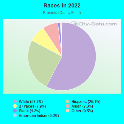
- 37957.7%White
- 16525.1%Hispanic or Latino
- 527.9%Two or more races
- 487.3%Asian
- 81.2%Black
- 30.5%Some other race
- 20.3%American Indian
Median household income in 2022:
| Presidio (Crissy Field): | $238,171 |
| San Francisco: | $136,692 |
Distribution of median household income
![Distribution of median household income]()
- 1,072Less than $10,000
- 512$10,000 to $19,999
- 365$20,000 to $29,999
- 360$30,000 to $39,999
- 124$40,000 to $49,999
- 10$50,000 to $59,999
- 13$60,000 to $74,999
- 7$75,000 to $99,999
- 25$100,000 to $124,999
- 15$125,000 to $149,999
- 21$150,000 to $199,999
- 159$200,000 or more

Distribution of owner-occupied house/condo value
![Distribution of owner-occupied house/condo value]()
- 281Less than $50,000
- 20$100,000 to $149,999
- 126$200,000 to $249,999
- 129$400,000 to $499,999
- 76$500,000 to $749,999
- 4,643$1,000,000 or more

Distribution of rent paid by renters
![Distribution of rent paid by renters]()
- 466$200 to $299
- 1,521$300 to $399
- 88$400 to $499
- 777$500 to $599
- 68$600 to $699
- 4$900 to $999
- 363$1,000 to $1,249
- 290$1,250 to $1,499
- 3$1,500 to $1,999
- 219$2,000 or more

Median rent in 2022:
| Presidio (Crissy Field): | $3,478 |
| San Francisco: | $2,001 |
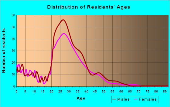
| Males: | 296 |
| Females: | 361 |
Males:
| This neighborhood: | 37.7 years |
| Whole city: | 40.3 years |
| This neighborhood: | 40.8 years |
| Whole city: | 40.5 years |
Average household size:
| Presidio (Crissy Field): | 2.4 people |
| San Francisco: | 2.2 people |
Percentage of family households:
| Presidio (Crissy Field): | 45.7% |
| San Francisco: | 30.3% |
| Here: | 40.5% |
| San Francisco: | 35.3% |
Percentage of married-couple families with children (among all households):
| Presidio (Crissy Field): | 27.0% |
| San Francisco: | 35.9% |
Percentage of single-mother households (among all households):
| Presidio (Crissy Field): | 11.7% |
| San Francisco: | 6.0% |
Percentage of never married males 15 years old and over:
Percentage of never married females 15 years old and over:
| Presidio (Crissy Field): | 18.7% |
| San Francisco: | 24.6% |
Percentage of never married females 15 years old and over:
| Presidio (Crissy Field): | 26.8% |
| city: | 19.9% |
Percentage of people that speak English not well or not at all:
| Presidio (Crissy Field): | 0.0% |
| San Francisco: | 10.9% |
Percentage of people born in this state:
Percentage of people born in another U.S. state:
Percentage of native residents but born outside the U.S.:
Percentage of foreign born residents:
| Here: | 47.7% |
| San Francisco: | 40.8% |
Percentage of people born in another U.S. state:
| Presidio (Crissy Field): | 34.8% |
| San Francisco: | 23.4% |
Percentage of native residents but born outside the U.S.:
| Here: | 1.5% |
| city: | 2.6% |
Percentage of foreign born residents:
| Here: | 16.0% |
| San Francisco: | 33.2% |
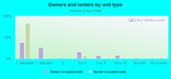
Owner-occupied
Renter-occupied

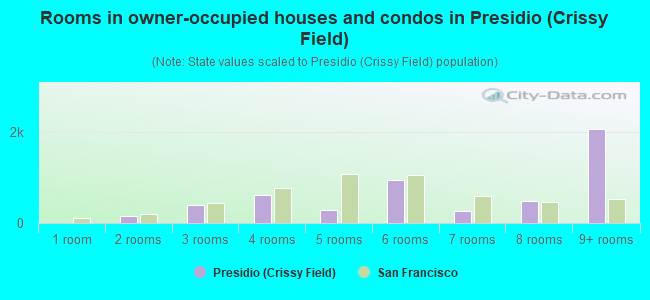
- Rooms in owner-occupied houses and condos in Presidio <
> - 01 room
- 1452 rooms
- 3983 rooms
- 6224 rooms
- 2875 rooms
- 9436 rooms
- 2677 rooms
- 4778 rooms
- 2,0709+ rooms
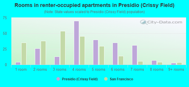
- Rooms in renter-occupied apartments in Presidio <
> - 41 room
- 262 rooms
- 133 rooms
- 704 rooms
- 405 rooms
- 356 rooms
- 317 rooms
- 78 rooms
- 39+ rooms
Owner-occupied
Renter-occupied
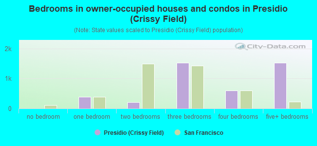
- Bedrooms in owner-occupied houses and condos in Presidio <
> - 0no bedroom
- 3981 bedroom
- 2172 bedrooms
- 1,5283 bedrooms
- 5994 bedrooms
- 1,5225+ bedrooms
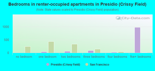
- Bedrooms in renter-occupied apartments in Presidio <
> - 4no bedroom
- 501 bedroom
- 652 bedrooms
- 893 bedrooms
- 234 bedrooms
- 9845+ bedrooms
Average number of cars or other vehicles available in houses/condos:
Average number of cars or other vehicles available in apartments:
| This neighborhood: | |
| San Francisco: |
Average number of cars or other vehicles available in apartments:
| Here: | 1.5 |
| city: | 0.8 |
Percentage of units with a mortgage:
| Presidio (Crissy Field): | 64.2% |
| San Francisco: | 62.3% |
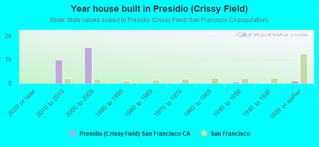
- Year house built in Presidio <
> - 02020 or later
- 9842010 to 2019
- 1,4932000 to 2009
- 81990 to 1999
- 41980 to 1989
- 241970 to 1979
- 221960 to 1969
- 711950 to 1959
- 221940 to 1949
- 1131939 or earlier
City-data.com crime index for city in 2020 (higher means more crime):
| City: | 387.4 |
| U.S. average: | 219.5 |
Travel time to work (commute)
![Travel time to work (commute)]()
- 3Less than 5 minutes
- 75 to 9 minutes
- 3310 to 14 minutes
- 7315 to 19 minutes
- 5120 to 24 minutes
- 3325 to 29 minutes
- 7630 to 34 minutes
- 2435 to 39 minutes
- 2440 to 44 minutes
- 3145 to 59 minutes
- 3460 to 89 minutes
- 2290 or more minutes

Means of transportation to work
![Means of transportation to work]()
- 45.6%186Drove a car alone
- 4.2%17Carpooled
- 10.1%41Bus
- 10.3%42Subway or elevated rail
- 28.5%116Long-distance train or commuter rail
- 0.2%1Ferryboat
- 2.0%8Taxi
- 1.2%5Motorcycle
- 4.4%18Bicycle
- 7.1%29Walked
- 2.2%9Other means
- 25.5%104Worked at home

Time leaving home to go to work
![Time leaving home to go to work]()
- 23912:00 a.m. to 4:59 a.m.
- 65:00 a.m. to 5:29 a.m.
- 175:30 a.m. to 5:59 a.m.
- 126:00 a.m. to 6:29 a.m.
- 196:30 a.m. to 6:59 a.m.
- 557:00 a.m. to 7:29 a.m.
- 967:30 a.m. to 7:59 a.m.
- 1088:00 a.m. to 8:29 a.m.
- 408:30 a.m. to 8:59 a.m.
- 319:00 a.m. to 9:59 a.m.
- 1710:00 a.m. to 10:59 a.m.
- 211:00 a.m. to 11:59 a.m.
- 1312:00 p.m. to 3:59 p.m.
- 54:00 p.m. to 11:59 p.m.

Occupations of males:
- Percentage of males in management occupations (except farmers):
Here: 34.8% city: 17.2%
- Percentage of males in business and financial operations occupations:
Here: 9.7% city: 8.9%
- Percentage of males in computer and mathematical occupations:
Here: 6.2% city: 14.6%
- Percentage of males in architecture and engineering occupations:
Here: 7.4% city: 4.0%
- Percentage of males in life, physical, and social science occupations:
Here: 5.2% city: 2.4%
- Percentage of males in legal occupations:
Here: 1.8% city: 2.5%
- Percentage of males in education, training, and library occupations:
Here: 1.2% city: 3.4%
- Percentage of males in arts, design, entertainment, sports, and media occupations:
Here: 4.4% city: 4.9%
- Percentage of males in healthcare practitioners and technical occupations:
Here: 1.4% city: 3.2%
- Percentage of males in service occupations:
Here: 11.2% city: 11.8%
- Percentage of males in sales and office occupations:
Here: 11.9% city: 13.5%
- Percentage of males in transportation occupations:
Here: 1.4% city: 3.4%
- Percentage of males in material moving occupations:
Here: 1.1% city: 1.8%
Occupations of females:
- Percentage of females in management occupations (except farmers):
Here: 12.2% city: 15.8%
- Percentage of females in business and financial operations occupations:
Here: 16.6% city: 11.5%
- Percentage of females in computer and mathematical occupations:
Here: 3.7% city: 5.1%
- Percentage of females in legal occupations:
Here: 5.7% city: 3.0%
- Percentage of females in education, training, and library occupations:
Here: 8.7% city: 7.1%
- Percentage of females in arts, design, entertainment, sports, and media occupations:
Here: 8.0% city: 5.1%
- Percentage of females in healthcare practitioners and technical occupations:
Here: 4.1% city: 8.4%
- Percentage of females in service occupations:
Here: 12.9% city: 15.4%
- Percentage of females in sales and office occupations:
Here: 19.0% city: 19.3%
- Percentage of females in construction, extraction, and maintenance occupations:
Here: 1.5% city: 0.1%
- Percentage of females in transportation occupations:
Here: 6.0% city: 0.8%
Percentage of people 16-64 in Armed Forces:
| Presidio (Crissy Field): | 0.1% |
| San Francisco: | 0.1% |
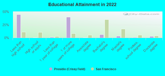
Education in this neighborhood (subdivision or community):
- Percentage of people 3 years and older in K-12 schools:
Presidio (Crissy Field): 11.2% San Francisco: 9.7%
- Percentage of people 3 years and older in undergraduate colleges:
Presidio (Crissy Field): 3.7% San Francisco: 4.8%
- Percentage of people 3 years and older in grad. or professional schools:
Presidio (Crissy Field): 1.5% San Francisco: 2.6%
- Percentage of students K-12 enrolled in private schools:
Presidio (Crissy Field): 5340.6% San Francisco: 36.5%
Percentage of population below poverty level:
| Presidio (Crissy Field): | 3.0% |
| San Francisco: | 10.4% |
Median year renter moved in (as recorded in 2022):
| Presidio (Crissy Field): | 2015 |
| San Francisco: | 2019 |
Percentage of married-couple families with both working:
| Presidio (Crissy Field): | 718.5% |
| San Francisco: | 75.9% |
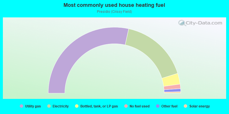
- 56.9%Utility gas
- 33.4%Electricity
- 5.3%Bottled, tank, or LP gas
- 2.2%No fuel used
- 1.5%Other fuel
- 0.7%Solar energy
Highways in this neighborhood:
State Hwy 1 (US Hwy 101)
Length: 4.02 miles
Directions: E-W, N-S, SE-NW
Directions: E-W, N-S, SE-NW
State Hwy 1
Length: 2.22 miles
Directions: N-S, SE-NW, SW-NE
Address range: 1200 to 1690
Directions: N-S, SE-NW, SW-NE
Address range: 1200 to 1690
US Hwy 101 (Richardson Ave)
Length: 0.09 miles
Direction: E-W
Direction: E-W
Roads and streets:
Lincoln Blvd
Length: 3.67 miles
Directions: E-W, N-S, SE-NW, SW-NE
Address range: 46 to 965
Directions: E-W, N-S, SE-NW, SW-NE
Address range: 46 to 965
Washington Blvd
Length: 1.35 miles
Directions: E-W, N-S, SE-NW, SW-NE
Address range: 400 to 1426
Directions: E-W, N-S, SE-NW, SW-NE
Address range: 400 to 1426
Park Blvd
Length: 1.27 miles
Directions: E-W, N-S, SE-NW, SW-NE
Directions: E-W, N-S, SE-NW, SW-NE
Mason St
Length: 1.23 miles
Directions: E-W, N-S, SE-NW, SW-NE
Directions: E-W, N-S, SE-NW, SW-NE
Presidio Blvd
Length: 0.97 miles
Directions: E-W, N-S, SE-NW, SW-NE
Address range: 51 to 517
Directions: E-W, N-S, SE-NW, SW-NE
Address range: 51 to 517
Amatury Loop
Length: 0.93 miles
Directions: E-W, N-S, SE-NW, SW-NE
Address range: 400 to 499
Directions: E-W, N-S, SE-NW, SW-NE
Address range: 400 to 499
Arguello Blvd
Length: 0.88 miles
Directions: E-W, N-S, SE-NW, SW-NE
Address range: 340 to 342
Directions: E-W, N-S, SE-NW, SW-NE
Address range: 340 to 342
Sheridan Ave
Length: 0.78 miles
Directions: E-W, N-S, SE-NW, SW-NE
Directions: E-W, N-S, SE-NW, SW-NE
Kobbe Ave
Length: 0.76 miles
Directions: E-W, SE-NW, SW-NE
Address range: 1302 to 1399
Directions: E-W, SE-NW, SW-NE
Address range: 1302 to 1399
Old Mason St
Length: 0.69 miles
Direction: E-W
Direction: E-W
Ralston Ave
Length: 0.61 miles
Directions: E-W, N-S, SE-NW, SW-NE
Address range: 85 to 91
Directions: E-W, N-S, SE-NW, SW-NE
Address range: 85 to 91
Simonds Loop
Length: 0.61 miles
Directions: E-W, N-S, SE-NW, SW-NE
Address range: 500 to 544
Directions: E-W, N-S, SE-NW, SW-NE
Address range: 500 to 544
Marine Dr
Length: 0.61 miles
Directions: E-W, N-S, SE-NW
Directions: E-W, N-S, SE-NW
Pershing Dr
Length: 0.60 miles
Directions: E-W, N-S, SE-NW, SW-NE
Address range: 1504 to 1599
Directions: E-W, N-S, SE-NW, SW-NE
Address range: 1504 to 1599
Hitchcock St
Length: 0.59 miles
Directions: E-W, N-S, SE-NW, SW-NE
Directions: E-W, N-S, SE-NW, SW-NE
Infantry Ter
Length: 0.57 miles
Directions: E-W, N-S, SE-NW, SW-NE
Address range: 300 to 399
Directions: E-W, N-S, SE-NW, SW-NE
Address range: 300 to 399
Storey Ave
Length: 0.50 miles
Directions: E-W, N-S, SE-NW
Address range: 1200 to 1299
Directions: E-W, N-S, SE-NW
Address range: 1200 to 1299
Crissy Field Ave
Length: 0.48 miles
Directions: E-W, N-S, SE-NW
Address range: 52 to 56
Directions: E-W, N-S, SE-NW
Address range: 52 to 56
Macarthur Ave
Length: 0.46 miles
Directions: N-S, SW-NE
Address range: 799 to 899
Directions: N-S, SW-NE
Address range: 799 to 899
Gorgas Ave
Length: 0.46 miles
Directions: E-W, SE-NW
Address range: 24 to 32
Directions: E-W, SE-NW
Address range: 24 to 32
Piper Loop
Length: 0.42 miles
Directions: E-W, N-S, SE-NW, SW-NE
Directions: E-W, N-S, SE-NW, SW-NE
Mesa St
Length: 0.40 miles
Direction: SW-NE
Direction: SW-NE
Harde Ave
Length: 0.38 miles
Directions: E-W, SE-NW, SW-NE
Directions: E-W, SE-NW, SW-NE
Allen St
Length: 0.37 miles
Direction: E-W
Direction: E-W
Funston Ave
Length: 0.36 miles
Direction: SW-NE
Address range: 1 to 67
Direction: SW-NE
Address range: 1 to 67
Graham St
Length: 0.36 miles
Direction: SW-NE
Direction: SW-NE
Letterman Dr
Length: 0.35 miles
Directions: E-W, SE-NW, SW-NE
Directions: E-W, SE-NW, SW-NE
Battery East Rd
Length: 0.35 miles
Directions: E-W, N-S, SE-NW
Directions: E-W, N-S, SE-NW
Ruckman Ave
Length: 0.34 miles
Directions: E-W, N-S, SE-NW
Address range: 1200 to 1299
Directions: E-W, N-S, SE-NW
Address range: 1200 to 1299
Rodriguez St
Length: 0.34 miles
Directions: E-W, N-S, SE-NW, SW-NE
Directions: E-W, N-S, SE-NW, SW-NE
Upton Ave
Length: 0.34 miles
Directions: N-S, SE-NW, SW-NE
Directions: N-S, SE-NW, SW-NE
Pacific Ave
Length: 0.34 miles
Direction: E-W
Address range: 3301 to 3599
Direction: E-W
Address range: 3301 to 3599
Sumner St
Length: 0.33 miles
Directions: E-W, N-S, SE-NW, SW-NE
Directions: E-W, N-S, SE-NW, SW-NE
Vallejo St
Length: 0.32 miles
Directions: E-W, N-S, SE-NW, SW-NE
Directions: E-W, N-S, SE-NW, SW-NE
Bowley St
Length: 0.32 miles
Directions: E-W, N-S, SE-NW, SW-NE
Directions: E-W, N-S, SE-NW, SW-NE
Armistead Rd
Length: 0.31 miles
Directions: E-W, N-S, SE-NW, SW-NE
Address range: 1200 to 1299
Directions: E-W, N-S, SE-NW, SW-NE
Address range: 1200 to 1299
Montgomery St
Length: 0.31 miles
Direction: SW-NE
Direction: SW-NE
Hoffman St
Length: 0.30 miles
Directions: E-W, SE-NW, SW-NE
Directions: E-W, SE-NW, SW-NE
Wright Loop
Length: 0.29 miles
Directions: E-W, N-S, SE-NW, SW-NE
Address range: 1328 to 1335
Directions: E-W, N-S, SE-NW, SW-NE
Address range: 1328 to 1335
Moraga Ave
Length: 0.29 miles
Directions: E-W, SE-NW
Directions: E-W, SE-NW
Keyes Ave
Length: 0.29 miles
Directions: E-W, N-S, SE-NW, SW-NE
Directions: E-W, N-S, SE-NW, SW-NE
Compton Rd
Length: 0.28 miles
Directions: E-W, SE-NW, SW-NE
Address range: 1400 to 1499
Directions: E-W, SE-NW, SW-NE
Address range: 1400 to 1499
Cowles St
Length: 0.28 miles
Directions: E-W, SE-NW, SW-NE
Directions: E-W, SE-NW, SW-NE
Battery Caulfield Rd
Length: 0.28 miles
Directions: N-S, SW-NE
Address range: 42 to 1499
Directions: N-S, SW-NE
Address range: 42 to 1499
French Ct
Length: 0.27 miles
Directions: E-W, N-S, SE-NW, SW-NE
Directions: E-W, N-S, SE-NW, SW-NE
Battery Blaney Rd
Length: 0.27 miles
Directions: E-W, SE-NW, SW-NE
Directions: E-W, SE-NW, SW-NE
Lundeen St
Length: 0.27 miles
Directions: E-W, N-S, SW-NE
Directions: E-W, N-S, SW-NE
Fisher Loop
Length: 0.27 miles
Directions: E-W, SE-NW, SW-NE
Directions: E-W, SE-NW, SW-NE
Portola St
Length: 0.26 miles
Directions: N-S, SE-NW, SW-NE
Address range: 701 to 799
Directions: N-S, SE-NW, SW-NE
Address range: 701 to 799
W Pacific Ave
Length: 0.26 miles
Directions: E-W, N-S, SE-NW, SW-NE
Directions: E-W, N-S, SE-NW, SW-NE
Liggett Ave
Length: 0.26 miles
Directions: N-S, SE-NW, SW-NE
Address range: 700 to 799
Directions: N-S, SE-NW, SW-NE
Address range: 700 to 799
Hays
Length: 0.25 miles
Directions: E-W, N-S, SE-NW, SW-NE
Directions: E-W, N-S, SE-NW, SW-NE
Sanches St
Length: 0.25 miles
Directions: E-W, N-S, SE-NW, SW-NE
Address range: 700 to 799
Directions: E-W, N-S, SE-NW, SW-NE
Address range: 700 to 799
Edie Rd
Length: 0.25 miles
Direction: E-W
Direction: E-W
Schofield Rd
Length: 0.25 miles
Directions: E-W, N-S, SE-NW
Directions: E-W, N-S, SE-NW
Merchant Rd
Length: 0.24 miles
Directions: E-W, N-S, SE-NW, SW-NE
Directions: E-W, N-S, SE-NW, SW-NE
Thomas Ave
Length: 0.24 miles
Directions: E-W, N-S, SE-NW, SW-NE
Directions: E-W, N-S, SE-NW, SW-NE
Banks St
Length: 0.23 miles
Directions: E-W, N-S, SE-NW, SW-NE
Directions: E-W, N-S, SE-NW, SW-NE
Anza Ave
Length: 0.23 miles
Directions: N-S, SW-NE
Directions: N-S, SW-NE
Sherman Rd
Length: 0.23 miles
Directions: E-W, SE-NW
Directions: E-W, SE-NW
Dewitt Rd
Length: 0.23 miles
Directions: E-W, SE-NW, SW-NE
Directions: E-W, SE-NW, SW-NE
Shafter Rd
Length: 0.23 miles
Directions: E-W, SE-NW, SW-NE
Directions: E-W, SE-NW, SW-NE
Hamilton St
Length: 0.23 miles
Directions: E-W, N-S, SE-NW, SW-NE
Directions: E-W, N-S, SE-NW, SW-NE
Morton St
Length: 0.22 miles
Directions: E-W, N-S, SE-NW
Address range: 775 to 783
Directions: E-W, N-S, SE-NW
Address range: 775 to 783
Appleton St
Length: 0.22 miles
Directions: E-W, N-S, SE-NW, SW-NE
Directions: E-W, N-S, SE-NW, SW-NE
Quarry Rd
Length: 0.21 miles
Directions: N-S, SW-NE
Address range: 800 to 899
Directions: N-S, SW-NE
Address range: 800 to 899
Gibson Rd
Length: 0.21 miles
Directions: E-W, N-S, SE-NW, SW-NE
Address range: 1775 to 1781
Directions: E-W, N-S, SE-NW, SW-NE
Address range: 1775 to 1781
Mauldin St
Length: 0.21 miles
Directions: E-W, N-S, SE-NW, SW-NE
Directions: E-W, N-S, SE-NW, SW-NE
Howard Rd
Length: 0.21 miles
Directions: E-W, SE-NW
Directions: E-W, SE-NW
Halleck St
Length: 0.20 miles
Direction: N-S
Direction: N-S
Stillwell Rd
Length: 0.20 miles
Directions: E-W, N-S, SE-NW
Address range: 1500 to 1599
Directions: E-W, N-S, SE-NW
Address range: 1500 to 1599
Wyman Ave
Length: 0.20 miles
Directions: E-W, N-S, SE-NW, SW-NE
Address range: 1800 to 1899
Directions: E-W, N-S, SE-NW, SW-NE
Address range: 1800 to 1899
McDowell Ave
Length: 0.20 miles
Direction: N-S
Direction: N-S
Sibert Loop
Length: 0.20 miles
Directions: E-W, N-S, SE-NW, SW-NE
Directions: E-W, N-S, SE-NW, SW-NE
Barnard Ave
Length: 0.20 miles
Directions: E-W, N-S, SE-NW, SW-NE
Directions: E-W, N-S, SE-NW, SW-NE
Wedemeyer
Length: 0.20 miles
Directions: E-W, SE-NW
Directions: E-W, SE-NW
Patten Rd
Length: 0.19 miles
Directions: E-W, SW-NE
Directions: E-W, SW-NE
Clark St
Length: 0.19 miles
Directions: N-S, SE-NW, SW-NE
Directions: N-S, SE-NW, SW-NE
Jauss St
Length: 0.19 miles
Direction: E-W
Direction: E-W
Taylor Rd
Length: 0.18 miles
Direction: SW-NE
Direction: SW-NE
Ruger St
Length: 0.17 miles
Directions: E-W, N-S, SE-NW, SW-NE
Directions: E-W, N-S, SE-NW, SW-NE
Battery Wagner Rd
Length: 0.17 miles
Directions: E-W, SE-NW
Directions: E-W, SE-NW
Girard Rd
Length: 0.17 miles
Directions: E-W, SW-NE
Address range: 36 to 47
Directions: E-W, SW-NE
Address range: 36 to 47
Young St
Length: 0.16 miles
Directions: E-W, N-S, SE-NW
Directions: E-W, N-S, SE-NW
McRae St
Length: 0.16 miles
Directions: E-W, N-S, SE-NW, SW-NE
Directions: E-W, N-S, SE-NW, SW-NE
Doyle
Length: 0.16 miles
Direction: E-W
Direction: E-W
Kennedy Ave
Length: 0.16 miles
Direction: SW-NE
Direction: SW-NE
Lombard St
Length: 0.16 miles
Direction: E-W
Direction: E-W
Sibley Rd (Sibly Rd)
Length: 0.16 miles
Directions: N-S, SE-NW, SW-NE
Address range: 700 to 799
Directions: N-S, SE-NW, SW-NE
Address range: 700 to 799
el Polin Loop
Length: 0.15 miles
Directions: E-W, N-S, SE-NW, SW-NE
Directions: E-W, N-S, SE-NW, SW-NE
Mitchell St
Length: 0.15 miles
Directions: N-S, SE-NW
Directions: N-S, SE-NW
Pearce St
Length: 0.15 miles
Direction: E-W
Direction: E-W
Wisser Ct
Length: 0.15 miles
Directions: E-W, SE-NW
Directions: E-W, SE-NW
Battery Chamberlin Rd
Length: 0.14 miles
Directions: N-S, SE-NW, SW-NE
Directions: N-S, SE-NW, SW-NE
Birmingham Rd
Length: 0.14 miles
Directions: E-W, SE-NW
Directions: E-W, SE-NW
Battery Dynamite Rd
Length: 0.14 miles
Directions: E-W, SE-NW
Directions: E-W, SE-NW
Freeman St
Length: 0.13 miles
Directions: SE-NW, SW-NE
Directions: SE-NW, SW-NE
Marshall St
Length: 0.13 miles
Direction: N-S
Direction: N-S
Harrison Blvd
Length: 0.13 miles
Direction: SW-NE
Direction: SW-NE
Brown St
Length: 0.13 miles
Directions: N-S, SW-NE
Directions: N-S, SW-NE
Torney Ave
Length: 0.13 miles
Direction: E-W
Direction: E-W
Battery Safford Rd
Length: 0.12 miles
Directions: N-S, SW-NE
Directions: N-S, SW-NE
McNair Ct
Length: 0.12 miles
Directions: E-W, N-S, SE-NW, SW-NE
Directions: E-W, N-S, SE-NW, SW-NE
Thornburg Rd
Length: 0.12 miles
Direction: E-W
Direction: E-W
Martinez St
Length: 0.12 miles
Directions: E-W, N-S, SE-NW, SW-NE
Directions: E-W, N-S, SE-NW, SW-NE
Oreilly Ave
Length: 0.12 miles
Direction: SW-NE
Address range: 1000 to 1099
Direction: SW-NE
Address range: 1000 to 1099
Sibley Rd
Length: 0.12 miles
Directions: E-W, N-S, SE-NW, SW-NE
Directions: E-W, N-S, SE-NW, SW-NE
el Camino del Mar
Length: 0.12 miles
Directions: E-W, SW-NE
Directions: E-W, SW-NE
Chism Rd
Length: 0.12 miles
Direction: N-S
Direction: N-S
Truby St
Length: 0.11 miles
Direction: SW-NE
Direction: SW-NE
Long Ave
Length: 0.11 miles
Directions: N-S, SE-NW
Directions: N-S, SE-NW
Bliss Rd
Length: 0.11 miles
Directions: SE-NW, SW-NE
Directions: SE-NW, SW-NE
Belles St
Length: 0.10 miles
Directions: E-W, N-S, SE-NW, SW-NE
Directions: E-W, N-S, SE-NW, SW-NE
Incinerator Rd
Length: 0.10 miles
Directions: N-S, SW-NE
Directions: N-S, SW-NE
Wool Ct
Length: 0.10 miles
Directions: E-W, N-S, SE-NW, SW-NE
Directions: E-W, N-S, SE-NW, SW-NE
Baker Ct
Length: 0.10 miles
Directions: E-W, SW-NE
Address range: 1700 to 1799
Directions: E-W, SW-NE
Address range: 1700 to 1799
Howe Rd
Length: 0.10 miles
Directions: N-S, SE-NW
Directions: N-S, SE-NW
Ramsell Ct (Ramsel Ct)
Length: 0.10 miles
Directions: E-W, N-S, SW-NE
Address range: 1200 to 1299
Directions: E-W, N-S, SW-NE
Address range: 1200 to 1299
Langdon Ct
Length: 0.10 miles
Directions: E-W, N-S, SE-NW, SW-NE
Directions: E-W, N-S, SE-NW, SW-NE
Muir Loop
Length: 0.09 miles
Directions: E-W, N-S, SE-NW
Address range: 1 to 99
Directions: E-W, N-S, SE-NW
Address range: 1 to 99
Greenough Ave
Length: 0.09 miles
Directions: N-S, SE-NW, SW-NE
Directions: N-S, SE-NW, SW-NE
Wallen St
Length: 0.09 miles
Direction: SW-NE
Address range: 855 to 867
Direction: SW-NE
Address range: 855 to 867
Todd St
Length: 0.09 miles
Directions: E-W, N-S, SE-NW
Directions: E-W, N-S, SE-NW
Riley Ave
Length: 0.09 miles
Directions: N-S, SW-NE
Address range: 118 to 199
Directions: N-S, SW-NE
Address range: 118 to 199
Javowitz St
Length: 0.09 miles
Direction: N-S
Direction: N-S
Fernandez St
Length: 0.09 miles
Direction: E-W
Address range: 800 to 811
Direction: E-W
Address range: 800 to 811
McDonald St
Length: 0.09 miles
Direction: SW-NE
Direction: SW-NE
N 15th Ave
Length: 0.09 miles
Direction: N-S
Direction: N-S
Patton Ct
Length: 0.08 miles
Directions: E-W, N-S, SE-NW, SW-NE
Directions: E-W, N-S, SE-NW, SW-NE
Wedemeyer St
Length: 0.08 miles
Direction: N-S
Direction: N-S
Livinston St
Length: 0.08 miles
Direction: N-S
Direction: N-S
Pope Ct
Length: 0.08 miles
Directions: SE-NW, SW-NE
Directions: SE-NW, SW-NE
Hicks Rd
Length: 0.08 miles
Direction: SW-NE
Direction: SW-NE
Lendrum Ct
Length: 0.08 miles
Directions: N-S, SE-NW
Address range: 1200 to 1299
Directions: N-S, SE-NW
Address range: 1200 to 1299
Howard Ct
Length: 0.08 miles
Directions: N-S, SE-NW
Directions: N-S, SE-NW
Kinzey St
Length: 0.07 miles
Directions: E-W, SE-NW, SW-NE
Directions: E-W, SE-NW, SW-NE
Gibbon Ct
Length: 0.07 miles
Directions: E-W, N-S, SE-NW, SW-NE
Directions: E-W, N-S, SE-NW, SW-NE
Stone St
Length: 0.07 miles
Directions: E-W, SW-NE
Directions: E-W, SW-NE
Wallen Ct
Length: 0.07 miles
Directions: E-W, SW-NE
Address range: 856 to 866
Directions: E-W, SW-NE
Address range: 856 to 866
Kendall Dr
Length: 0.07 miles
Direction: SW-NE
Direction: SW-NE
Miles Ct
Length: 0.07 miles
Directions: N-S, SE-NW, SW-NE
Directions: N-S, SE-NW, SW-NE
Young Ct
Length: 0.07 miles
Directions: E-W, N-S, SE-NW, SW-NE
Directions: E-W, N-S, SE-NW, SW-NE
Ord St
Length: 0.07 miles
Direction: SW-NE
Direction: SW-NE
Battery Cranston Rd
Length: 0.07 miles
Direction: SE-NW
Direction: SE-NW
Barry Ct
Length: 0.06 miles
Directions: N-S, SW-NE
Directions: N-S, SW-NE
Brooks St
Length: 0.06 miles
Direction: N-S
Address range: 1700 to 1799
Direction: N-S
Address range: 1700 to 1799
Hwy 101 N on Rmp
Length: 0.06 miles
Directions: E-W, SE-NW
Directions: E-W, SE-NW
Vista Ct
Length: 0.06 miles
Directions: E-W, SW-NE
Address range: 781 to 799
Directions: E-W, SW-NE
Address range: 781 to 799
Bank St
Length: 0.06 miles
Direction: N-S
Direction: N-S
Kearny Ln
Length: 0.05 miles
Directions: E-W, SE-NW
Directions: E-W, SE-NW
S Hughes Ln
Length: 0.05 miles
Directions: E-W, SE-NW
Directions: E-W, SE-NW
Muir Ct
Length: 0.05 miles
Directions: E-W, N-S, SW-NE
Directions: E-W, N-S, SW-NE
Rawles St
Length: 0.05 miles
Directions: E-W, SW-NE
Directions: E-W, SW-NE
Soule Ln
Length: 0.05 miles
Direction: N-S
Direction: N-S
Hitchcock Ln
Length: 0.05 miles
Directions: N-S, SW-NE
Directions: N-S, SW-NE
Deems Rd
Length: 0.05 miles
Directions: E-W, SW-NE
Directions: E-W, SW-NE
Greely Ct
Length: 0.05 miles
Directions: N-S, SE-NW
Directions: N-S, SE-NW
Johnstone Dr
Length: 0.05 miles
Directions: E-W, N-S, SE-NW, SW-NE
Directions: E-W, N-S, SE-NW, SW-NE
Hwt 101 N Off Ramp
Length: 0.05 miles
Directions: N-S, SW-NE
Directions: N-S, SW-NE
Murray Ln
Length: 0.04 miles
Directions: N-S, SW-NE
Directions: N-S, SW-NE
Schofield
Length: 0.04 miles
Directions: N-S, SE-NW, SW-NE
Directions: N-S, SE-NW, SW-NE
McRae Ln
Length: 0.04 miles
Directions: N-S, SW-NE
Directions: N-S, SW-NE
Winn Way
Length: 0.04 miles
Direction: E-W
Direction: E-W
Sternberg Rd
Length: 0.04 miles
Directions: E-W, SW-NE
Directions: E-W, SW-NE
Seawell Ln
Length: 0.04 miles
Directions: N-S, SE-NW
Directions: N-S, SE-NW
Pennington
Length: 0.04 miles
Direction: N-S
Direction: N-S
Gibbon Ln
Length: 0.04 miles
Direction: N-S
Direction: N-S
Bliss Ct
Length: 0.04 miles
Directions: E-W, N-S
Directions: E-W, N-S
Walker Ct
Length: 0.04 miles
Directions: N-S, SW-NE
Directions: N-S, SW-NE
N Hughes Ln
Length: 0.04 miles
Direction: N-S
Direction: N-S
Crook St
Length: 0.03 miles
Direction: N-S
Direction: N-S
Sal St
Length: 0.03 miles
Direction: SE-NW
Direction: SE-NW
Thomas Ct
Length: 0.03 miles
Direction: N-S
Direction: N-S
Craig Ct
Length: 0.03 miles
Direction: SW-NE
Direction: SW-NE
Wright Ct
Length: 0.03 miles
Directions: N-S, SW-NE
Directions: N-S, SW-NE
Canby St
Length: 0.03 miles
Direction: SE-NW
Direction: SE-NW
Owens St
Length: 0.03 miles
Direction: SE-NW
Direction: SE-NW
Bowley Ct
Length: 0.03 miles
Directions: N-S, SW-NE
Directions: N-S, SW-NE
Pena St
Length: 0.03 miles
Direction: SE-NW
Direction: SE-NW
Menoher Ln
Length: 0.03 miles
Directions: N-S, SE-NW
Directions: N-S, SE-NW
Smith Ln
Length: 0.03 miles
Directions: N-S, SE-NW
Directions: N-S, SE-NW
Clarke Ln
Length: 0.03 miles
Directions: E-W, SW-NE
Directions: E-W, SW-NE
Hays St
Length: 0.02 miles
Direction: E-W
Direction: E-W
Merriam Ln
Length: 0.02 miles
Direction: N-S
Direction: N-S
Canby Ln
Length: 0.02 miles
Direction: N-S
Direction: N-S
N Van Horn Ln
Length: 0.02 miles
Direction: N-S
Direction: N-S
Beale St
Length: 0.02 miles
Direction: N-S
Direction: N-S
Treat Ln
Length: 0.02 miles
Directions: N-S, SW-NE
Directions: N-S, SW-NE
Blatchford Ln
Length: 0.02 miles
Direction: SW-NE
Direction: SW-NE
Sibert Ln
Length: 0.02 miles
Direction: N-S
Direction: N-S
Bliss St
Length: 0.02 miles
Direction: SE-NW
Direction: SE-NW
Bell Ct
Length: 0.02 miles
Directions: N-S, SW-NE
Directions: N-S, SW-NE
Forsyth Ln
Length: 0.02 miles
Direction: N-S
Direction: N-S
W Halleck St
Length: 0.00 miles
Direction: SW-NE
Direction: SW-NE