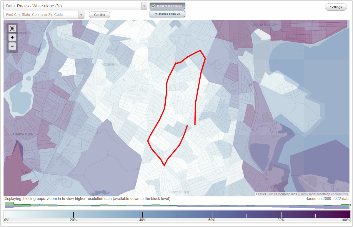
Brunswick King (Dudley) neighborhood in Boston, Massachusetts (MA), 02119, 02121, 02125 detailed profile
Settings
X

Business Search - 14 Million verified businesses
Area: 0.668 square miles
Population: 16,208
Population density:
| Brunswick King (Dudley): | 24,258 people per square mile |
| Boston: | 13,418 people per square mile |

- 7,96244.9%Black
- 4,97228.0%Hispanic or Latino
- 1,86910.5%Two or more races
- 1,2577.1%White
- 6353.6%Some other race
- 5643.2%American Indian
- 4712.7%Asian

Distribution of median household income
![Distribution of median household income]()
- 538Less than $10,000
- 1,022$10,000 to $19,999
- 701$20,000 to $29,999
- 741$30,000 to $39,999
- 703$40,000 to $49,999
- 268$50,000 to $59,999
- 467$60,000 to $74,999
- 772$75,000 to $99,999
- 393$100,000 to $124,999
- 372$125,000 to $149,999
- 407$150,000 to $199,999
- 578$200,000 or more

Distribution of owner-occupied house/condo value
![Distribution of owner-occupied house/condo value]()
- 432Less than $50,000
- 435$50,000 to $99,999
- 189$100,000 to $149,999
- 574$150,000 to $199,999
- 135$200,000 to $249,999
- 141$250,000 to $299,999
- 500$300,000 to $399,999
- 450$400,000 to $499,999
- 464$500,000 to $749,999
- 439$750,000 to $999,999
- 832$1,000,000 or more

Distribution of rent paid by renters
![Distribution of rent paid by renters]()
- 438Less than $100
- 918$100 to $199
- 474$200 to $299
- 646$300 to $399
- 716$400 to $499
- 865$500 to $599
- 368$600 to $699
- 559$700 to $799
- 373$800 to $899
- 206$900 to $999
- 586$1,000 to $1,249
- 607$1,250 to $1,499
- 580$1,500 to $1,999
- 1,343$2,000 or more

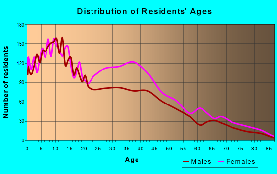
| Males: | 7,819 |
| Females: | 8,388 |
Males:
| This neighborhood: | 31.7 years |
| Whole city: | 32.7 years |
| This neighborhood: | 39.1 years |
| Whole city: | 34.1 years |
Average household size:
| Brunswick King (Dudley): | 4.1 people |
| Boston: | 2.1 people |
Percentage of family households:
| Brunswick King (Dudley): | 56.1% |
| Boston: | 34.5% |
| Here: | 31.4% |
| Boston: | 26.9% |
Percentage of married-couple families with children (among all households):
| Brunswick King (Dudley): | 14.8% |
| Boston: | 24.9% |
Percentage of single-mother households (among all households):
| Brunswick King (Dudley): | 15.8% |
| Boston: | 15.7% |
Percentage of never married males 15 years old and over:
Percentage of never married females 15 years old and over:
| Brunswick King (Dudley): | 24.3% |
| Boston: | 26.8% |
Percentage of never married females 15 years old and over:
| Brunswick King (Dudley): | 29.4% |
| city: | 28.3% |
Percentage of people that speak English not well or not at all:
| Brunswick King (Dudley): | 16.3% |
| Boston: | 8.0% |
Percentage of people born in this state:
Percentage of people born in another U.S. state:
Percentage of native residents but born outside the U.S.:
Percentage of foreign born residents:
| Here: | 48.2% |
| Boston: | 42.4% |
Percentage of people born in another U.S. state:
| Brunswick King (Dudley): | 8.9% |
| Boston: | 26.6% |
Percentage of native residents but born outside the U.S.:
| Here: | 5.9% |
| city: | 3.3% |
Percentage of foreign born residents:
| Here: | 37.1% |
| Boston: | 27.6% |
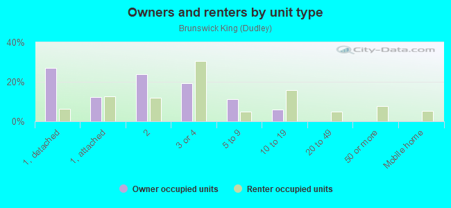
Owner-occupied
Renter-occupied

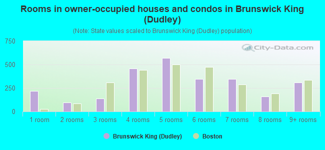
- Rooms in owner-occupied houses and condos in Brunswick King <
> - 2181 room
- 942 rooms
- 1403 rooms
- 4584 rooms
- 5695 rooms
- 3456 rooms
- 3477 rooms
- 1598 rooms
- 3119+ rooms
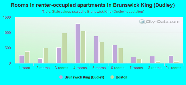
- Rooms in renter-occupied apartments in Brunswick King <
> - 2551 room
- 1562 rooms
- 5193 rooms
- 1,2924 rooms
- 8885 rooms
- 5926 rooms
- 2127 rooms
- 2288 rooms
- 2479+ rooms
Owner-occupied
Renter-occupied
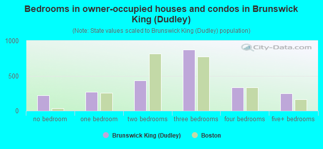
- Bedrooms in owner-occupied houses and condos in Brunswick King <
> - 218no bedroom
- 2661 bedroom
- 4362 bedrooms
- 8753 bedrooms
- 3334 bedrooms
- 2505+ bedrooms
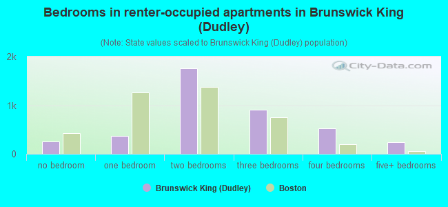
- Bedrooms in renter-occupied apartments in Brunswick King <
> - 260no bedroom
- 3671 bedroom
- 1,7542 bedrooms
- 9013 bedrooms
- 5224 bedrooms
- 2465+ bedrooms
Average number of cars or other vehicles available in houses/condos:
Average number of cars or other vehicles available in apartments:
| This neighborhood: | 1.4 |
| Boston: | 1.4 |
Average number of cars or other vehicles available in apartments:
| Here: | 0.7 |
| city: | 0.7 |
Percentage of units with a mortgage:
| Brunswick King (Dudley): | 69.0% |
| Boston: | 69.7% |
Housing prices:
- Average estimated value of housing units in 2-unit structures in 2022 (18.4% of all units):
This neighborhood: $817,728 Massachusetts: $594,808
- Average estimated '22 value of housing units in 3-to-4-unit structures (43.3% of all units):
Brunswick King (Dudley): $728,733 Massachusetts: $601,912
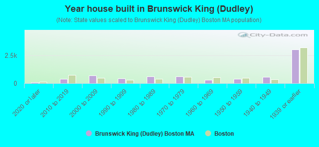
- Year house built in Brunswick King <
> - 842020 or later
- 4012010 to 2019
- 7042000 to 2009
- 4361990 to 1999
- 5951980 to 1989
- 6201970 to 1979
- 3031960 to 1969
- 3971950 to 1959
- 5531940 to 1949
- 2,9961939 or earlier
City-data.com crime index for city in 2020 (higher means more crime):
| City: | 258.2 |
| U.S. average: | 219.5 |
Travel time to work (commute)
![Travel time to work (commute)]()
- 132Less than 5 minutes
- 3265 to 9 minutes
- 41610 to 14 minutes
- 80015 to 19 minutes
- 1,00020 to 24 minutes
- 32725 to 29 minutes
- 1,63430 to 34 minutes
- 18635 to 39 minutes
- 23840 to 44 minutes
- 87545 to 59 minutes
- 74460 to 89 minutes
- 36190 or more minutes

Means of transportation to work
![Means of transportation to work]()
- 45.4%3,255Drove a car alone
- 11.7%840Carpooled
- 27.6%1,976Bus
- 6.4%461Subway or elevated rail
- 3.2%232Long-distance train or commuter rail
- 6.7%483Light rail, streetcar or trolley
- 3.0%217Ferryboat
- 1.9%137Taxi
- 4.3%306Bicycle
- 7.1%505Walked
- 6.0%432Other means
- 5.8%413Worked at home

Time leaving home to go to work
![Time leaving home to go to work]()
- 25112:00 a.m. to 4:59 a.m.
- 2955:00 a.m. to 5:29 a.m.
- 1875:30 a.m. to 5:59 a.m.
- 6706:00 a.m. to 6:29 a.m.
- 3836:30 a.m. to 6:59 a.m.
- 8867:00 a.m. to 7:29 a.m.
- 4147:30 a.m. to 7:59 a.m.
- 1,3348:00 a.m. to 8:29 a.m.
- 2788:30 a.m. to 8:59 a.m.
- 3359:00 a.m. to 9:59 a.m.
- 40410:00 a.m. to 10:59 a.m.
- 18111:00 a.m. to 11:59 a.m.
- 78512:00 p.m. to 3:59 p.m.
- 4154:00 p.m. to 11:59 p.m.

Occupations of males:
- Percentage of males in management occupations (except farmers):
Here: 7.7% city: 12.7%
- Percentage of males in business and financial operations occupations:
Here: 2.2% city: 9.1%
- Percentage of males in computer and mathematical occupations:
Here: 3.9% city: 7.4%
- Percentage of males in architecture and engineering occupations:
Here: 1.1% city: 3.1%
- Percentage of males in community and social services occupations:
Here: 3.1% city: 1.4%
- Percentage of males in education, training, and library occupations:
Here: 5.2% city: 5.7%
- Percentage of males in arts, design, entertainment, sports, and media occupations:
Here: 3.1% city: 2.7%
- Percentage of males in service occupations:
Here: 21.6% city: 16.0%
- Percentage of males in sales and office occupations:
Here: 21.8% city: 15.2%
- Percentage of males in construction, extraction, and maintenance occupations:
Here: 9.9% city: 4.4%
- Percentage of males in production occupations:
Here: 2.4% city: 2.4%
- Percentage of males in transportation occupations:
Here: 7.4% city: 4.7%
- Percentage of males in material moving occupations:
Here: 4.4% city: 2.3%
Occupations of females:
- Percentage of females in management occupations (except farmers):
Here: 4.0% city: 12.2%
- Percentage of females in business and financial operations occupations:
Here: 2.7% city: 9.5%
- Percentage of females in community and social services occupations:
Here: 3.9% city: 3.1%
- Percentage of females in legal occupations:
Here: 1.3% city: 2.3%
- Percentage of females in education, training, and library occupations:
Here: 7.2% city: 9.4%
- Percentage of females in arts, design, entertainment, sports, and media occupations:
Here: 1.1% city: 3.4%
- Percentage of females in healthcare practitioners and technical occupations:
Here: 4.2% city: 10.2%
- Percentage of females in service occupations:
Here: 39.7% city: 18.6%
- Percentage of females in sales and office occupations:
Here: 27.3% city: 20.2%
- Percentage of females in production occupations:
Here: 2.2% city: 1.5%
- Percentage of females in transportation occupations:
Here: 4.3% city: 0.8%
- Percentage of females in material moving occupations:
Here: 1.1% city: 1.0%
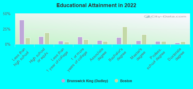
Education in this neighborhood (subdivision or community):
- Percentage of people 3 years and older in K-12 schools:
Brunswick King (Dudley): 28.8% Boston: 11.0%
- Percentage of people 3 years and older in undergraduate colleges:
Brunswick King (Dudley): 8.6% Boston: 11.0%
- Percentage of people 3 years and older in grad. or professional schools:
Brunswick King (Dudley): 4.0% Boston: 4.3%
- Percentage of students K-12 enrolled in private schools:
Brunswick King (Dudley): 42.3% Boston: 13.8%
Percentage of population below poverty level:
| Brunswick King (Dudley): | 23.3% |
| Boston: | 17.1% |
Percentage of married-couple families with both working:
| Brunswick King (Dudley): | 95.4% |
| Boston: | 78.2% |
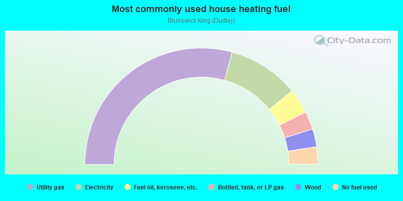
- 58.5%Utility gas
- 19.8%Electricity
- 6.9%Fuel oil, kerosene, etc.
- 5.0%Bottled, tank, or LP gas
- 5.0%Wood
- 4.8%No fuel used
Roads and streets:
Magnolia St
Length: 0.75 miles
Directions: N-S, SW-NE
Address range: 1 to 299
Directions: N-S, SW-NE
Address range: 1 to 299
Dudley St
Length: 0.65 miles
Directions: E-W, N-S, SE-NW
Address range: 414 to 689
Directions: E-W, N-S, SE-NW
Address range: 414 to 689
Howard Ave
Length: 0.64 miles
Directions: E-W, N-S, SW-NE
Address range: 1 to 299
Directions: E-W, N-S, SW-NE
Address range: 1 to 299
Shirley St
Length: 0.51 miles
Directions: E-W, SW-NE
Address range: 1 to 199
Directions: E-W, SW-NE
Address range: 1 to 199
Columbia Rd
Length: 0.51 miles
Directions: E-W, SW-NE
Address range: 165 to 358
Directions: E-W, SW-NE
Address range: 165 to 358
Geneva Ave
Length: 0.49 miles
Directions: E-W, SE-NW
Address range: 1 to 174
Directions: E-W, SE-NW
Address range: 1 to 174
Quincy St
Length: 0.45 miles
Directions: E-W, SE-NW
Address range: 112 to 265
Directions: E-W, SE-NW
Address range: 112 to 265
Clifton St
Length: 0.44 miles
Directions: E-W, N-S, SE-NW, SW-NE
Address range: 1 to 199
Directions: E-W, N-S, SE-NW, SW-NE
Address range: 1 to 199
Devon St
Length: 0.43 miles
Directions: E-W, SE-NW
Address range: 59 to 199
Directions: E-W, SE-NW
Address range: 59 to 199
Alexander St
Length: 0.42 miles
Directions: E-W, N-S, SE-NW, SW-NE
Address range: 1 to 199
Directions: E-W, N-S, SE-NW, SW-NE
Address range: 1 to 199
Wayland St
Length: 0.42 miles
Direction: E-W
Address range: 28 to 199
Direction: E-W
Address range: 28 to 199
Normandy St
Length: 0.39 miles
Direction: SW-NE
Address range: 1 to 172
Direction: SW-NE
Address range: 1 to 172
Brook Ave
Length: 0.37 miles
Directions: E-W, N-S, SE-NW, SW-NE
Address range: 1 to 142
Directions: E-W, N-S, SE-NW, SW-NE
Address range: 1 to 142
Hartford St
Length: 0.36 miles
Directions: N-S, SE-NW
Address range: 1 to 99
Directions: N-S, SE-NW
Address range: 1 to 99
Stanwood St
Length: 0.34 miles
Direction: SE-NW
Address range: 30 to 199
Direction: SE-NW
Address range: 30 to 199
Intervale St
Length: 0.34 miles
Directions: E-W, SE-NW
Address range: 71 to 199
Directions: E-W, SE-NW
Address range: 71 to 199
Burrell St
Length: 0.34 miles
Direction: E-W
Address range: 1 to 199
Direction: E-W
Address range: 1 to 199
Dacia St
Length: 0.32 miles
Directions: N-S, SW-NE
Address range: 1 to 199
Directions: N-S, SW-NE
Address range: 1 to 199
Langdon St
Length: 0.32 miles
Directions: E-W, SW-NE
Address range: 1 to 99
Directions: E-W, SW-NE
Address range: 1 to 99
W Cottage St
Length: 0.32 miles
Direction: E-W
Address range: 1 to 85
Direction: E-W
Address range: 1 to 85
Norfolk Ave
Length: 0.29 miles
Direction: SE-NW
Address range: 150 to 281
Direction: SE-NW
Address range: 150 to 281
Ceylon St
Length: 0.28 miles
Directions: N-S, SE-NW, SW-NE
Address range: 1 to 99
Directions: N-S, SE-NW, SW-NE
Address range: 1 to 99
Vaughan Ave
Length: 0.27 miles
Directions: N-S, SW-NE
Address range: 1 to 99
Directions: N-S, SW-NE
Address range: 1 to 99
E Cottage St
Length: 0.25 miles
Direction: E-W
Address range: 1 to 50
Direction: E-W
Address range: 1 to 50
Proctor St
Length: 0.24 miles
Directions: E-W, SW-NE
Address range: 1 to 98
Directions: E-W, SW-NE
Address range: 1 to 98
Sargent St
Length: 0.24 miles
Directions: E-W, N-S, SE-NW
Address range: 1 to 99
Directions: E-W, N-S, SE-NW
Address range: 1 to 99
Dennis St
Length: 0.24 miles
Direction: SW-NE
Address range: 1 to 99
Direction: SW-NE
Address range: 1 to 99
Julian St
Length: 0.23 miles
Directions: E-W, SE-NW
Address range: 15 to 99
Directions: E-W, SE-NW
Address range: 15 to 99
Lawrence Ave
Length: 0.23 miles
Direction: SE-NW
Address range: 28 to 154
Direction: SE-NW
Address range: 28 to 154
Marshfield St
Length: 0.21 miles
Directions: E-W, SW-NE
Address range: 1 to 99
Directions: E-W, SW-NE
Address range: 1 to 99
Batchelder St
Length: 0.21 miles
Directions: N-S, SE-NW
Address range: 1 to 99
Directions: N-S, SE-NW
Address range: 1 to 99
Dewey St
Length: 0.21 miles
Direction: E-W
Address range: 8 to 99
Direction: E-W
Address range: 8 to 99
Robin Hood St
Length: 0.20 miles
Directions: E-W, SW-NE
Address range: 1 to 99
Directions: E-W, SW-NE
Address range: 1 to 99
Brookford St
Length: 0.20 miles
Directions: E-W, SE-NW, SW-NE
Address range: 4 to 99
Directions: E-W, SE-NW, SW-NE
Address range: 4 to 99
Folsom St
Length: 0.19 miles
Directions: N-S, SE-NW, SW-NE
Address range: 1 to 99
Directions: N-S, SE-NW, SW-NE
Address range: 1 to 99
Robey St
Length: 0.18 miles
Directions: N-S, SE-NW, SW-NE
Address range: 1 to 121
Directions: N-S, SE-NW, SW-NE
Address range: 1 to 121
Woodward Ave
Length: 0.17 miles
Directions: E-W, SW-NE
Address range: 1 to 99
Directions: E-W, SW-NE
Address range: 1 to 99
Clarence St
Length: 0.17 miles
Directions: E-W, SW-NE
Address range: 1 to 98
Directions: E-W, SW-NE
Address range: 1 to 98
Woodford St
Length: 0.17 miles
Directions: E-W, N-S, SE-NW, SW-NE
Address range: 1 to 99
Directions: E-W, N-S, SE-NW, SW-NE
Address range: 1 to 99
Judson St
Length: 0.17 miles
Directions: N-S, SW-NE
Address range: 1 to 99
Directions: N-S, SW-NE
Address range: 1 to 99
Woodcliff St
Length: 0.16 miles
Directions: E-W, SE-NW
Address range: 18 to 99
Directions: E-W, SE-NW
Address range: 18 to 99
Rockford St
Length: 0.16 miles
Directions: E-W, SW-NE
Address range: 1 to 99
Directions: E-W, SW-NE
Address range: 1 to 99
Leyland St
Length: 0.15 miles
Directions: N-S, SE-NW
Address range: 1 to 99
Directions: N-S, SE-NW
Address range: 1 to 99
Lingard St
Length: 0.15 miles
Direction: E-W
Address range: 1 to 99
Direction: E-W
Address range: 1 to 99
Gayland St
Length: 0.15 miles
Directions: E-W, N-S
Address range: 1 to 99
Directions: E-W, N-S
Address range: 1 to 99
Cunningham St
Length: 0.14 miles
Direction: E-W
Address range: 1 to 99
Direction: E-W
Address range: 1 to 99
Shetland St
Length: 0.14 miles
Directions: N-S, SW-NE
Address range: 1 to 99
Directions: N-S, SW-NE
Address range: 1 to 99
Dean St
Length: 0.14 miles
Directions: E-W, SE-NW
Address range: 1 to 99
Directions: E-W, SE-NW
Address range: 1 to 99
Burgess St
Length: 0.13 miles
Directions: E-W, SW-NE
Address range: 1 to 99
Directions: E-W, SW-NE
Address range: 1 to 99
Harlow St
Length: 0.13 miles
Direction: SE-NW
Address range: 1 to 99
Direction: SE-NW
Address range: 1 to 99
Albion St
Length: 0.13 miles
Directions: E-W, SW-NE
Address range: 1 to 99
Directions: E-W, SW-NE
Address range: 1 to 99
Mascoma St
Length: 0.13 miles
Directions: N-S, SW-NE
Address range: 1 to 99
Directions: N-S, SW-NE
Address range: 1 to 99
George St
Length: 0.13 miles
Direction: SE-NW
Address range: 94 to 199
Direction: SE-NW
Address range: 94 to 199
Danube St
Length: 0.13 miles
Directions: N-S, SW-NE
Address range: 1 to 99
Directions: N-S, SW-NE
Address range: 1 to 99
Chamblet St
Length: 0.12 miles
Direction: E-W
Address range: 1 to 99
Direction: E-W
Address range: 1 to 99
Massachusetts Ave
Length: 0.12 miles
Direction: SE-NW
Direction: SE-NW
Oldfields Rd
Length: 0.12 miles
Direction: SE-NW
Address range: 1 to 99
Direction: SE-NW
Address range: 1 to 99
Woodville St
Length: 0.12 miles
Directions: E-W, N-S, SE-NW
Address range: 1 to 36
Directions: E-W, N-S, SE-NW
Address range: 1 to 36
Creston St
Length: 0.12 miles
Directions: E-W, SE-NW
Address range: 1 to 63
Directions: E-W, SE-NW
Address range: 1 to 63
Fayston St
Length: 0.12 miles
Direction: SE-NW
Address range: 33 to 99
Direction: SE-NW
Address range: 33 to 99
North Ave
Length: 0.11 miles
Direction: E-W
Address range: 1 to 99
Direction: E-W
Address range: 1 to 99
Fernboro St
Length: 0.11 miles
Direction: SW-NE
Address range: 1 to 99
Direction: SW-NE
Address range: 1 to 99
Beauford Ln
Length: 0.11 miles
Direction: E-W
Address range: 1 to 99
Direction: E-W
Address range: 1 to 99
Half Moon St
Length: 0.10 miles
Directions: E-W, N-S, SE-NW
Address range: 1 to 99
Directions: E-W, N-S, SE-NW
Address range: 1 to 99
Napa St
Length: 0.10 miles
Directions: N-S, SW-NE
Address range: 1 to 99
Directions: N-S, SW-NE
Address range: 1 to 99
Woodward Park St
Length: 0.10 miles
Direction: SE-NW
Address range: 1 to 99
Direction: SE-NW
Address range: 1 to 99
Moreland St
Length: 0.10 miles
Directions: E-W, SE-NW
Address range: 130 to 199
Directions: E-W, SE-NW
Address range: 130 to 199
Greenheys St
Length: 0.10 miles
Direction: SE-NW
Address range: 1 to 99
Direction: SE-NW
Address range: 1 to 99
Brinsley St
Length: 0.10 miles
Directions: N-S, SE-NW, SW-NE
Address range: 12 to 99
Directions: N-S, SE-NW, SW-NE
Address range: 12 to 99
Coleus Park
Length: 0.09 miles
Direction: SW-NE
Address range: 1 to 99
Direction: SW-NE
Address range: 1 to 99
Bird St
Length: 0.08 miles
Directions: E-W, SW-NE
Address range: 112 to 199
Directions: E-W, SW-NE
Address range: 112 to 199
Winthrop St
Length: 0.08 miles
Directions: E-W, SE-NW
Address range: 165 to 199
Directions: E-W, SE-NW
Address range: 165 to 199
Wyola Pl
Length: 0.08 miles
Directions: E-W, SE-NW
Address range: 1 to 99
Directions: E-W, SE-NW
Address range: 1 to 99
Morse St
Length: 0.08 miles
Direction: SW-NE
Address range: 1 to 99
Direction: SW-NE
Address range: 1 to 99
Longmeadow St
Length: 0.08 miles
Direction: E-W
Address range: 1 to 99
Direction: E-W
Address range: 1 to 99
Laredo St
Length: 0.08 miles
Direction: SW-NE
Address range: 1 to 31
Direction: SW-NE
Address range: 1 to 31
Brunswick St
Length: 0.07 miles
Direction: SE-NW
Address range: 143 to 299
Direction: SE-NW
Address range: 143 to 299
Balfour St
Length: 0.07 miles
Direction: N-S
Address range: 1 to 99
Direction: N-S
Address range: 1 to 99
Rand St
Length: 0.07 miles
Directions: N-S, SW-NE
Address range: 1 to 99
Directions: N-S, SW-NE
Address range: 1 to 99
Woodville Park
Length: 0.07 miles
Directions: E-W, SE-NW
Address range: 1 to 99
Directions: E-W, SE-NW
Address range: 1 to 99
Ronald St
Length: 0.07 miles
Directions: E-W, SE-NW
Address range: 1 to 99
Directions: E-W, SE-NW
Address range: 1 to 99
Magnolia Sq
Length: 0.07 miles
Direction: E-W
Address range: 1 to 99
Direction: E-W
Address range: 1 to 99
Dalkeith St
Length: 0.06 miles
Direction: E-W
Address range: 1 to 99
Direction: E-W
Address range: 1 to 99
Roswell St
Length: 0.06 miles
Directions: E-W, SE-NW
Address range: 1 to 99
Directions: E-W, SE-NW
Address range: 1 to 99
Lester St
Length: 0.06 miles
Direction: E-W
Address range: 1 to 99
Direction: E-W
Address range: 1 to 99
Dunkeld St
Length: 0.06 miles
Direction: SW-NE
Address range: 1 to 99
Direction: SW-NE
Address range: 1 to 99
Gouldville Ter
Length: 0.06 miles
Direction: E-W
Address range: 1 to 99
Direction: E-W
Address range: 1 to 99
Dalin Pl
Length: 0.06 miles
Direction: N-S
Address range: 1 to 99
Direction: N-S
Address range: 1 to 99
Dromey St
Length: 0.06 miles
Directions: SE-NW, SW-NE
Address range: 2 to 26
Directions: SE-NW, SW-NE
Address range: 2 to 26
Magnolia Pl
Length: 0.06 miles
Direction: E-W
Address range: 1 to 99
Direction: E-W
Address range: 1 to 99
Emrose Ter
Length: 0.05 miles
Direction: E-W
Address range: 1 to 99
Direction: E-W
Address range: 1 to 99
Perth St
Length: 0.05 miles
Direction: SW-NE
Address range: 1 to 99
Direction: SW-NE
Address range: 1 to 99
Woodledge St
Length: 0.05 miles
Direction: N-S
Address range: 1 to 199
Direction: N-S
Address range: 1 to 199
Rand Pl
Length: 0.05 miles
Direction: E-W
Address range: 1 to 99
Direction: E-W
Address range: 1 to 99
Victor St
Length: 0.05 miles
Direction: N-S
Address range: 1 to 99
Direction: N-S
Address range: 1 to 99
Oleander St
Length: 0.05 miles
Direction: E-W
Address range: 1 to 99
Direction: E-W
Address range: 1 to 99
Partridge Pl
Length: 0.05 miles
Direction: SW-NE
Address range: 1 to 99
Direction: SW-NE
Address range: 1 to 99
Hartford Ter
Length: 0.05 miles
Direction: SW-NE
Address range: 1 to 99
Direction: SW-NE
Address range: 1 to 99
Lebanon St
Length: 0.05 miles
Direction: E-W
Address range: 1 to 51
Direction: E-W
Address range: 1 to 51
Howard Pl
Length: 0.04 miles
Direction: SE-NW
Address range: 1 to 99
Direction: SE-NW
Address range: 1 to 99
Dove Ct
Length: 0.04 miles
Direction: N-S
Address range: 1 to 99
Direction: N-S
Address range: 1 to 99
Hartford Ct
Length: 0.04 miles
Direction: E-W
Address range: 1 to 99
Direction: E-W
Address range: 1 to 99
Sherwood Ct
Length: 0.04 miles
Direction: SE-NW
Address range: 1 to 99
Direction: SE-NW
Address range: 1 to 99
Dove St
Length: 0.04 miles
Direction: E-W
Address range: 8 to 99
Direction: E-W
Address range: 8 to 99
Lewis Pl
Length: 0.04 miles
Direction: SW-NE
Address range: 1 to 99
Direction: SW-NE
Address range: 1 to 99
Langdon Ter
Length: 0.04 miles
Direction: SE-NW
Address range: 1 to 99
Direction: SE-NW
Address range: 1 to 99
Creston Park
Length: 0.04 miles
Direction: SW-NE
Address range: 1 to 99
Direction: SW-NE
Address range: 1 to 99
Miller Park
Length: 0.04 miles
Direction: SW-NE
Address range: 1 to 99
Direction: SW-NE
Address range: 1 to 99
Readfield Pl
Length: 0.04 miles
Direction: N-S
Address range: 1 to 99
Direction: N-S
Address range: 1 to 99
Sweetfern Ter
Length: 0.04 miles
Directions: N-S, SW-NE
Address range: 1 to 99
Directions: N-S, SW-NE
Address range: 1 to 99
Stanwood Ter
Length: 0.03 miles
Direction: SW-NE
Address range: 1 to 99
Direction: SW-NE
Address range: 1 to 99
Rollins Ct
Length: 0.03 miles
Direction: SE-NW
Address range: 1 to 99
Direction: SE-NW
Address range: 1 to 99
Letterfine Ter
Length: 0.03 miles
Direction: E-W
Address range: 1 to 99
Direction: E-W
Address range: 1 to 99
Cottage Ct
Length: 0.03 miles
Direction: N-S
Address range: 1 to 99
Direction: N-S
Address range: 1 to 99
Downey Ct
Length: 0.03 miles
Direction: N-S
Address range: 1 to 99
Direction: N-S
Address range: 1 to 99
Columbia Ter
Length: 0.03 miles
Direction: SE-NW
Direction: SE-NW
Randlett Pl
Length: 0.03 miles
Direction: N-S
Address range: 1 to 99
Direction: N-S
Address range: 1 to 99
Toland Ct
Length: 0.02 miles
Direction: SW-NE
Address range: 1 to 99
Direction: SW-NE
Address range: 1 to 99
Intervale Ter
Length: 0.02 miles
Direction: SW-NE
Address range: 1 to 99
Direction: SW-NE
Address range: 1 to 99
Jarvis Pl
Length: 0.02 miles
Direction: E-W
Address range: 1 to 99
Direction: E-W
Address range: 1 to 99
Dewey Ter
Length: 0.02 miles
Direction: N-S
Address range: 1 to 99
Direction: N-S
Address range: 1 to 99
Hall Ave
Length: 0.02 miles
Direction: N-S
Address range: 1 to 99
Direction: N-S
Address range: 1 to 99
Railroad features:
Mbta Commuter Rail
Length: 1.27 miles
Directions: N-S, SW-NE
Directions: N-S, SW-NE
Penn Central RR
Length: 0.13 miles
Directions: N-S, SW-NE
Directions: N-S, SW-NE