Please register to participate in our discussions with 2 million other members - it's free and quick! Some forums can only be seen by registered members. After you create your account, you'll be able to customize options and access all our 15,000 new posts/day with fewer ads.
Sweeping that sweeping generalization aside, when it comes to URBAN planning, you have to have some plan. Growing higgly piggly is not conducive to high efficiency.
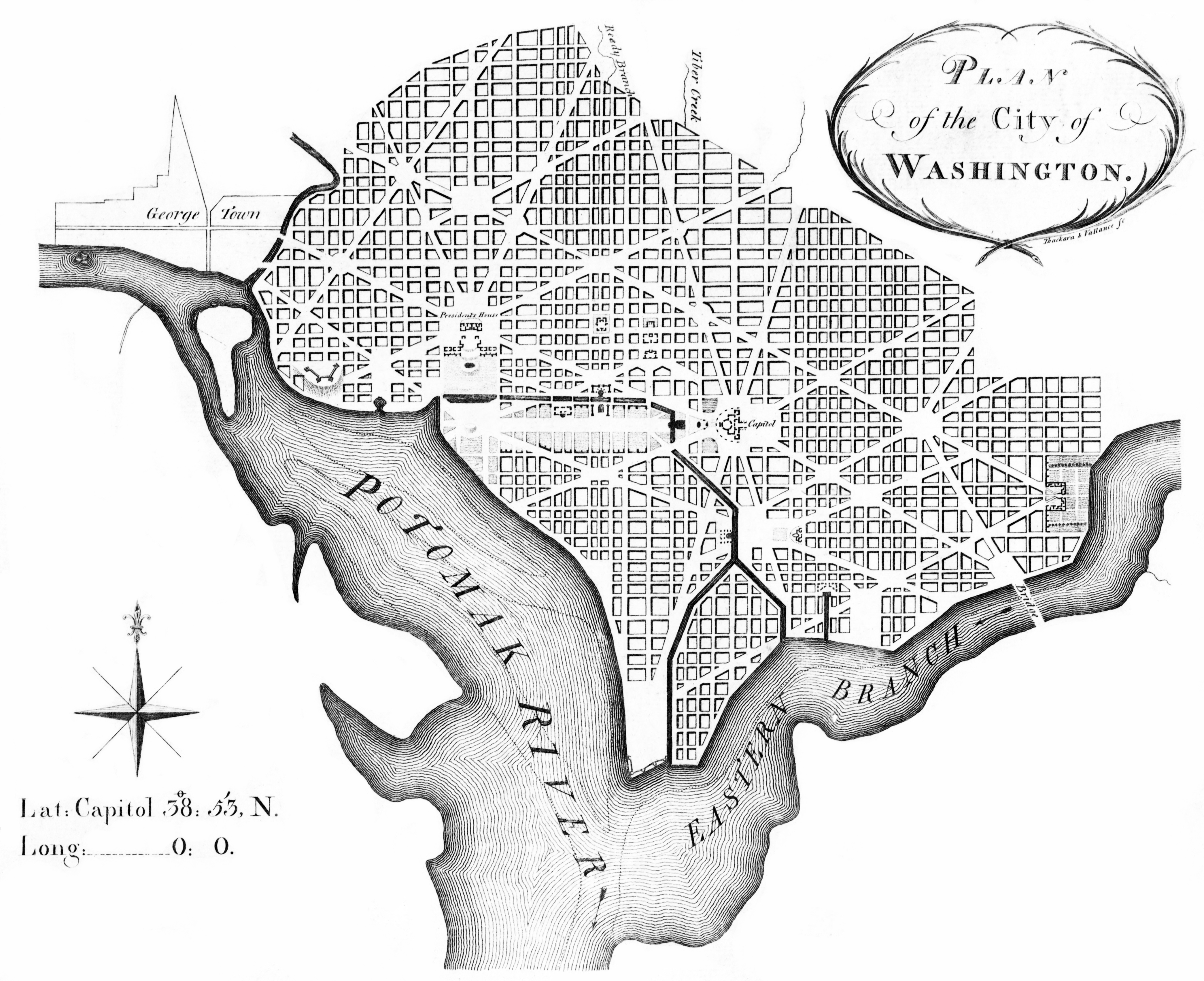
Consider City of Washington, District of Columbia. It was a planned city. And for the time, it was not too shabby.
Washington D.C. is organized through two major systems, figural voided radial axes and an underlying grid. The radial axes create hierarchy in the plan as they connect major architectural monuments such as Pennsylvania Avenue connecting the White House and Capitol Building.
If curves weren't such a pain to survey and layout, DC could have had concentric ring roads with an overlay of radial boulevards. https://ohiostate.pressbooks.pub/exp...washington-dc/
Sweeping that sweeping generalization aside, when it comes to URBAN planning, you have to have some plan. Growing higgly piggly is not conducive to high efficiency.
Consider City of Washington, District of Columbia. It was a planned city. And for the time, it was not too shabby.
Washington D.C. is organized through two major systems, figural voided radial axes and an underlying grid. The radial axes create hierarchy in the plan as they connect major architectural monuments such as Pennsylvania Avenue connecting the White House and Capitol Building.
If curves weren't such a pain to survey and layout, DC could have had concentric ring roads with an overlay of radial boulevards. https://ohiostate.pressbooks.pub/exp...washington-dc/
I had understood that the reason for the diagonal avenues slicing and dicing the grid was to make it more difficult for an invading army to advance on the city. Was this correct?
I had understood that the reason for the diagonal avenues slicing and dicing the grid was to make it more difficult for an invading army to advance on the city. Was this correct?
I would move major transit highways out of the cities. Cities don't need extra traffic caused by vehicles driving through. The highways could go around the cities with several exits to different parts of it. City loops would take care of the rest. With highways out of the cities the local traffic would be much more bearable.
I also would implement some laws about billboards. Our cities are infested by them. All kind of sizes and shapes, some heavily light polluting. They aren't pretty, most are useless. You can't enjoy the landscape or architecture of most cities. All you see are ugly billboards...
I had understood that the reason for the diagonal avenues slicing and dicing the grid was to make it more difficult for an invading army to advance on the city. Was this correct?
No, it was design by a Frenchman in a style similar to Paris.
Quote:
The paper, published Wednesday in the Journal of the Royal Society Interface, analyzed the geometry of blocks from 131 cities and created “fingerprints” representing how often different kinds of shapes occur. With its small, irregularly shaped blocks, the city that D.C. most closely resembles is Paris, says study co-author Remi Louf, of the Institute of Theoretical Physics in France.
“The distinct feature of these cities is the presence of radiating avenues that were built to connect different points in the city, and that do not respect the layout’s underlying geometry,” he explained via email. Those American cities built after the advent of the automobile have regular grids and large blocks. Older cities, like Boston and Baltimore, hark back to our pedestrian past, with smaller, more walkable blocks. But unlike our neighbors to the north, D.C.’s street pattern didn’t develop organically. It was planned — by notable Parisian Pierre L’Enfant.
L'Enfant was a French engineer who served in the Continental Army during the American Revolutionary War. In 1789, discussions were underway regarding a new federal capital city for the United States, and L'Enfant wrote to President Washington asking to be commissioned to plan the city.
Emphasizing the importance of the new nation's legislature, the Congress House would be located on a longitude designated as 0:0.[0:0 as the beginning for a new country]
After President Washington dismissed L'Enfant, Andrew Ellicott and his assistants continued the city survey in accordance with the revised plan, several versions of which were engraved, published, and distributed in Philadelphia and Boston. As a result, Ellicott's revision subsequently became the basis for the capital city's development.
The Burning of Washington was a British invasion of Washington City, the capital of the United States, during the Chesapeake campaign of the War of 1812. It was the only time since the American Revolutionary War that a foreign power has captured and occupied the capital of the United States.
After burning the Capitol, the British turned northwest up Pennsylvania Avenue toward the White House. After US government officials and President Madison fled the city, First Lady Dolley Madison received a letter from her husband, urging her to be prepared to leave Washington at a moment's notice. Dolley organized the enslaved and other staff to save valuables from the British. James Madison's personal enslaved attendant, the fifteen-year-old boy Paul Jennings, was an eyewitness. After later buying his freedom from the widow Dolley Madison, Jennings published his memoir in 1865, considered the first from the White House:
The original color of the White House was a natural grey in color because it was constructed with sandstone, not painted white. In 1814, during the War of 1812 with the British, the White House was burned with the interior destroyed and the exterior charred. White paint was used to cover up the charred marks
I would make city policies much tougher on its land.
1.) Remove all highways and freeways from the city
2.) own all of the real estate of rail lines that come into city territory and make them for subway/metro use so people in the city would have more affordable and more accessible transportation.
This would allow places like Manhattan to be way less congested with office spaces and force suburbanites to build communities if office parks of their own since they despise the cities so much despite depending on them for income.
How do you think American cities would differ if such things became true?
So you what to remove the ability to bring in any goods/services into the city. Don't forget the razor fencing.
So you what to remove the ability to bring in any goods/services into the city. Don't forget the razor fencing.
Not necessarily.
Freeways facilitate the transport of goods between and among cities rather than within them. Local thoroughfares prove adequate for that latter purpose just about everywhere.
Two cities for you to consider in this regard are Vancouver and London.
The one freeway that enters the Vancouver city limits clips its northeast corner. You can get off of it to reach the city via local streets.
London has a beltway around it, the M25 London Orbital. One or two freeways penetrate it but peter out after an exit or two. Otherwise, to reach central London, you must negotiate city streets.
Both cities get along quite well with this arrangement, and the shelves of their stores are full in both.
Edited to add a historical note backing up this general sentiment: There is in the archives of the Federal Highway Administration a memo from the administrator sometime in 1958 or thereabouts in which he relates receiving word from President Eisenhower that he was horrified to see bulldozers clearing land inside the District of Columbia in order to insert a freeway. He had envisioned the Interstate Highway System that bears his name now as consisting of "interregional" highways (which was the word used in the ?1944? Federal Government report that studied the question of whether such superhighways should be built after the success of the Pennsylvania Turnpike) rather than intrametropolitan or intra-urban ones.
But the more the freeways penetrate the city the easier it is to utilize multiple thoroughfares. And what is a thoroughfare? How many stops per mile? It depends on many things like the size of a city, the geography, etc. It's never one size fits all.
Please register to post and access all features of our very popular forum. It is free and quick. Over $68,000 in prizes has already been given out to active posters on our forum. Additional giveaways are planned.
Detailed information about all U.S. cities, counties, and zip codes on our site: City-data.com.

 Please register to participate in our discussions with 2 million other members - it's free and quick! Some forums can only be seen by registered members. After you create your account, you'll be able to customize options and access all our 15,000 new posts/day with fewer ads.