Where is warmest weather in Idaho? (Boise, Lewiston: home, snake, winter)
Please register to participate in our discussions with 2 million other members - it's free and quick! Some forums can only be seen by registered members. After you create your account, you'll be able to customize options and access all our 15,000 new posts/day with fewer ads.
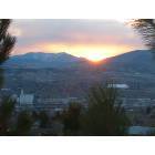
Gotta be Lewiston as the hottest town in Idaho. To me though, Boise is almost as hot and is a kind of a city....easy choice for me if I returned to Idaho would be Boise.
That's just not right for this time in October. It makes me worry when the ground hasn't frozen some by now.
Huge warm air mass over most of the continental US. Daily record highs will likely occur in many places.
( The National Weather Service office in Dodge City, Kan., is calling for a “spooky hot Halloween” with highs near 90, challenging several records in the western part of the state.)
As the lone Weiser holdout, I wasn't too far off- Weiser averages only a degree colder than either Lewiston or Riggins.
It's the humidity in Weiser, I guess, that makes me feel so hot when I'm there.
All 3 are in low spots that are surrounded by mountains. The big difference, it appears, is Riggins and Lewiston are both in narrow canyons. Weiser isn't, but it lies on the banks of the Snake.
Using the criteria of a canyon bottom town, Hagerman is warmer than Lewiston and as warm as Riggins at the high temp, but the average temp is 3º lower. That may be due to how wide the canyon bottom is in the Hagerman area. Hagerman gets more sun than Lewiston and Riggins.
Weiser was on my short list for a retirement location....but it is colder in winter. It really isn't that far from McCall. In fact, at one time I considered taking a job in McCall and commuting from Weiser.
Weiser was on my short list for a retirement location....but it is colder in winter. It really isn't that far from McCall. In fact, at one time I considered taking a job in McCall and commuting from Weiser.
Elevation makes huge differences here, and we have extreme differences in elevation that can deceive someone who doesn't know Idaho, because it is so mountainous here. One place can be a thousand feet lower than another that's only 30 miles away or less, and this difference abounds all over the state.
In addition, the entire southern part of the state is higher overall than the panhandle. That's due to the hot spot that carved a path across the state from the west and now lies under Yellowstone.
Even our mountains are deceptive; the Teton range, which lies on the border between Wyoming and Idaho, appears to be higher on the eastern Wyoming slope, but the Idaho side is actually much higher from valley floor to valley floor.
The reason it looks higher is because the Teton basin got sucked under the earth's surface when the tectonic plate it was on was driven under when the larger one to the east collided with it and drove over it. That collision created the hot spot.
Please register to post and access all features of our very popular forum. It is free and quick. Over $68,000 in prizes has already been given out to active posters on our forum. Additional giveaways are planned.
Detailed information about all U.S. cities, counties, and zip codes on our site: City-data.com.

 Please register to participate in our discussions with 2 million other members - it's free and quick! Some forums can only be seen by registered members. After you create your account, you'll be able to customize options and access all our 15,000 new posts/day with fewer ads.