Please register to participate in our discussions with 2 million other members - it's free and quick! Some forums can only be seen by registered members. After you create your account, you'll be able to customize options and access all our 15,000 new posts/day with fewer ads.
Location: The Greatest city on Earth: City of Atlanta Proper
8,487 posts, read 15,015,710 times
Reputation: 7344
Advertisements
Quote:
Originally Posted by Mutiny77
Atlanta is well north of the fall line and centrally located within the Piedmont which renders the Chattahoochee non-navigable. It's the same reason why none of NC's Piedmont cities were built directly along rivers, and Virginia has only the narrowest strip of Piedmont west of the fall line before the transition to the Appalachians begins--hence its urban distribution. Had it not been for Atlanta's strategic location along an east/west bend in the Eastern Continental Divide which made it an ideal location for a major rail hub connecting Southern and Midwestern markets--which also happened to be a rather central location within the Southeast still in the Eastern time zone--in all likelihood it would have never become a major U.S. city.
100% this but you also mentioned something else that casually gets ignored is that this city sits in a geographic region marked by hundreds of valleys and hills that just quite big enough to not be called a hill but too small to be mountain. It also doesn't help that these hills are mostly made of granite and monzonite which are two very hard rocks to quarry.
The short version when you add all of is that a good chunk of the reason Atlanta looks the way it does is due to our geography, not poor urban planning (well, not totally). This can be especially seen in the neighborhoods that were built as streetcar suburbs. The streets are windy because the engineers were taking advantage of gravity to allow the streetcars to move easier and to avoid random rock formations that would've been hard for 19th century crews to clear.
The prevailing urbanist thought is that we should be disgusted by this and a lack of a water feature. I like that it makes us unique.
Last edited by waronxmas; 05-09-2023 at 12:02 PM..
The short version when you add all of is that a good chunk of the reason Atlanta looks the way it does is due to our geography, not poor urban planning (well, not totally). This can be especially seen in the neighborhoods that were built as streetcar suburbs. The streets are windy because the engineers were taking advantage of gravity to allow the streetcars to move easier and to avoid random rock formations that would've been hard for 19th century crews to clear.
The prevailing urbanist thought is that we should be disgusted by this and a lack of a water feature. I like that it makes us unique.
Tony Ressler is quite the visionary. It is a firewall article, but here are some key quotes.
Atlanta Business Chronicles, "The billionaire hedge fund manager told Atlanta Business Chronicle that the $5 billion project could add 10,000 residents, 30,000 jobs, hotels, 1 million square feet of office space and an entertainment district to Downtown that might rival The Battery Atlanta in Cobb County (Ressler)".
Tony Ressler said Atlanta, his home for six months of the year, is extraordinary, but the vast array of useless railroad tracks and subterranean parking kills the Downtown district.
As of right now, there is no Downtown, Ressler said. Filling that hole will not only change that, but transform the entire metro area for the next 50 years.
100% this but you also mentioned something else that casually gets ignored is that this city sits in a geographic region marked by hundreds of valleys and hills that just quite big enough to not be called a hill but too small to be mountain. It also doesn't help that these hills are mostly made of granite and monzonite which are two very hard rocks to quarry.
The short version when you add all of is that a good chunk of the reason Atlanta looks the way it does is due to our geography, not poor urban planning (well, not totally). This can be especially seen in the neighborhoods that were built as streetcar suburbs. The streets are windy because the engineers were taking advantage of gravity to allow the streetcars to move easier and to avoid random rock formations that would've been hard for 19th century crews to clear.
The prevailing urbanist thought is that we should be disgusted by this and a lack of a water feature. I like that it makes us unique.
I see where you are coming. The low density sprawl is a bonus in comparison to higher density sprawl found in the top 5 U.S. populated metro areas (and also heavily in China). Low density sprawl offers lower pollution and greater benefits for pedestrians and bicyclists.
Unfortunately, not many have tapped into the advantages that the area offers. Public transit still lacks in many areas.
Madrid is a great example. The grid... what is that? And it has no navigable waterways. Madrid is not as hilly I don't think but it has some mountains in and around the city. Ain't no one saying that Madrid has poor urban planning. Google is telling me the nearest port of navigability in Spain is Cordoba, which is much further than Atlanta to Columbus.
Chisinau in Moldova is also a major Euro city with no navigable waterways and is inland. In fact the Bac can even be reduced to ponds and lakes in the summer so it's tributary isn't even reliable. Chisinau also has good urban planning.
Brussels covered up their river system and while they do have a canal that runs through the city is lined up with what appears to be mostly industrial use and thus also fits under the "inland city with no real major water features" like Atlanta since we technically have the Chattahoochee but it's not a core of our development minus industrial.
Beijing also really lacks any navigable waterways or a riverfront and is inland. Who says Beijing doesn't have good urban planning?
La Paz is another major city which paved over its river, and has significant elevation changes which would put Atlanta to shame. La Paz also has a better built form, and lacks a grid.
Santiago is a city that while technically has a river and a small riverfront in it's core, is so narrow that it almost looks more like a canal or a small channel. It doesn't seem to be as much of a defining feature.
Bangalore another major city in the world lacks a defining water feature and is inland, but relatively flat.
Yes Atlanta is hilly but again if they can achieve good form in Madrid, Santiago, etc. then they can also do so here. Hills are a poor excuse when humans can develop big cities right on top of mountainsides (see La Paz). Rome is infamously known to be built on seven hills and it's road network reflects that but that did not stop Rome being what it is today which is a lovely walkable city. San Francisco yes gridded mostly still hilly and has good urban built form. So grid + hills (San Francisco) and no grid + hills (Rome) you can have a well built city as well as no hills + no grid (Santiago/Beijing). In theory they are arguing that grid + no hills (Chicago) is the easiest to plan for urbanism and they may be right in the sense that it is "easiest" but if humans can and have created walkable and dense cities in quite the opposite of such it can be easily done here.
In fact many urbanists would argue that grids actually are not the best urban design in the sense that they are boring from a pedestrian perspective, discouraging walking, and make for a lack of defining areas and neighborhoods as well as arguing that grids were only a modern invention meant to facilitate the movement of people via streetcars, private cars, etc. Atlanta is one of few cities in America that actually have curving roads with some form of density built on them since most American cities only have density on gridded streets in the core, Buckhead is where most of our examples lie.One can argue that Midtown and Downtown are gridded but that is a big stretch of the definition. Boston of course is a better example. But the fact that many argue that winding roads helps facilitate a better pedestrian experience should be taken into consideration as well.
I wanted to propose a thought experiment with the Chattahoochee because while yes there are other cities like Atlanta (no grid + hills + lack of water feature) it's an extremely rare combination in comparison to other cities globally and that if our core was no grid + hills + water feature it'd put us in line with most of Europe and that would we have seen better success in revitalization or development had we done so. I'm not ad versed in the city's history.
It’s not Atlanta’s lack of a water feature in or right next to its downtown area that makes it different from more compact and walkable European cities.
It’s that Atlanta (like every other large major Sun Belt metro) experienced most of its development into a large major metropolitan area during the post-World War II era of mass middle-class flight from the traditionally more compact and walkable urban core to the sprawling automobile-oriented suburbs and exurbs.
For a central city and urban core that experienced a significant amount of flight to the suburbs and exurbs from the 1950’s through the 1980’s, Atlanta’s urban core (including and starting with the City of Atlanta proper) has done exceedingly well to experience revitalization and renaissance with a very noticeable increase in growth, development and redevelopment in many urban core neighborhoods Intown and ITP.
Intown Atlanta and ITP metro Atlanta obviously have room for continued growth and improvement, but Intown Atlanta and ITP metro Atlanta generally have been doing extremely well in recent years.
Atlanta’s berth as host of the 1996 Summer Olympic Games appeared to help generate increased interest in urban living in Intown Atlanta.
And though Intown Atlanta and ITP metro Atlanta was experiencing a significant amount of revitalization before the Great Recession, Intown Atlanta and ITP metro Atlanta really appeared to start to hit its stride after the Great Recession as metro Atlanta evolved into a major international hub of technology industry activity with large clusters of tech companies in Midtown Atlanta and Alpharetta.
Atlanta obviously is not a compact walkable European-style city, but Atlanta still has experienced a massive amount of economic, public relations and developmental success since the 1990 announcement that Atlanta would host the 1996 Summer Olympic Games… That massive success includes the growth revitalization of many more compact urban core neighborhoods ITP.
Atlanta’s experience of post WWII suburbia is not replicated in other cities around the world especially newer cities that have developed after the invention of the car like nearly every Chinese city has rebuilt itself as well as Japan and of course South American cities too. Atlanta is making progress but the progress is weak and also inexcusable especially we consider the timelines of other developments worldwide. Transit and even real estate developments are approved and built not only globally faster in most places but also even elsewhere in the US. How the US treats infrastructure is terrible and Atlanta is the one of the worst at it for the US which is even worse. This needs to be a priority among Atlantans in general in all counties to say we need better planning and traffic management. I know I’ve said it before but that doesn’t necessarily mean construction projects but they need to be policies that work towards reducing volume and/or raising funds for infrastructure in addition to actual physical projects. I’ve made a list of it somewhere maybe I’ll go back and quote myself, could’ve sworn I said it in the Atlanta subforum.
Atlanta has a lot of land zoned for light industry, more so than other cities. My question is whether or not this is good or best land usage. When we look at the Chattahoochee for example, a lot of it is zoned industrial. How much of that NEEDS to be on a non-navigable river? Is it something that if it was already zoned there due to placing Downtown historically OR rezoning in the modern day, would it have helped increase funds? Economic studies point out that urban residents cost less to governments than suburban or rural residents to cover basic services like fire police utilities. If an urban district was on a riverfront and therefore by many considered more desirable, would Atlanta have had a better start due to being able to build up land with higher real estate appeal or in the modern day be able to get more tax dollars in contrast to tax dollars spent to provide services and be able to complete other restoration projects elsewhere in the city?
Atlanta’s experience of post WWII suburbia is not replicated in other cities around the world especially newer cities that have developed after the invention of the car like nearly every Chinese city has rebuilt itself as well as Japan and of course South American cities too. Atlanta is making progress but the progress is weak and also inexcusable especially we consider the timelines of other developments worldwide. Transit and even real estate developments are approved and built not only globally faster in most places but also even elsewhere in the US. How the US treats infrastructure is terrible and Atlanta is the one of the worst at it for the US which is even worse. This needs to be a priority among Atlantans in general in all counties to say we need better planning and traffic management. I know I’ve said it before but that doesn’t necessarily mean construction projects but they need to be policies that work towards reducing volume and/or raising funds for infrastructure in addition to actual physical projects. I’ve made a list of it somewhere maybe I’ll go back and quote myself, could’ve sworn I said it in the Atlanta subforum.
The condition of a large major metropolitan area like Atlanta experiencing most of its growth in the form of low-density suburban and exurban sprawl after World War II may not be replicated in many other cities around the world, but the condition of a large major metropolitan area experiencing most of its growth in the form of low-density suburban and exurban sprawl is exceedingly typical for large major metropolitan areas and regions across the greater American Sun Belt region, including Orlando, Dallas/Fort Worth, Houston, San Antonio, Nashville, Raleigh-Durham, Charlotte, Phoenix, Las Vegas, and Southern California.
Quote:
Originally Posted by Prickly Pear
Atlanta has a lot of land zoned for light industry, more so than other cities. My question is whether or not this is good or best land usage. When we look at the Chattahoochee for example, a lot of it is zoned industrial. How much of that NEEDS to be on a non-navigable river? Is it something that if it was already zoned there due to placing Downtown historically OR rezoning in the modern day, would it have helped increase funds? Economic studies point out that urban residents cost less to governments than suburban or rural residents to cover basic services like fire police utilities. If an urban district was on a riverfront and therefore by many considered more desirable, would Atlanta have had a better start due to being able to build up land with higher real estate appeal or in the modern day be able to get more tax dollars in contrast to tax dollars spent to provide services and be able to complete other restoration projects elsewhere in the city?
When the industrial area along the Chattahoochee River was originally developed during the decade of the 1960’s, it was still generally considered to be on the western edge of Atlanta’s then infinitely smaller urban area.
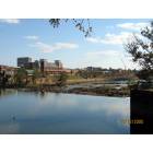
But it seems to be worth noting that the Chattahoochee River is only lined with industrial development from below (south of) the south end of the Vinings area. North of the Vinings area, much (if not most) of the Chattahoochee River is lined with federally protected green spaces and outdoor recreational areas all the way up to Lake Lanier.
The lack of navigability of the Chattahoochee River seems to be a major reason why Atlanta was not settled on the Chattahoochee River and why Atlanta’s downtown area is not located on the Chattahoochee River.
Because of the lack of navigability of the Chattahoochee River and because of the rolling-to-hilly Piedmont Plateau terrain of the area which is located fairly close to the southern end of the Blue Ridge Mountains, Atlanta originated as a railroad crossing and grew up as a railroad town around a busy hub of railroad tracks that are located in the Gulch area of Downtown Atlanta.
That’s because Atlanta’s original location (which was a zero mile post marker for the southern end (or Southern Terminus) of the Western & Atlantic Railroad near very what is now the Gulch area of Downtown Atlanta) was almost about the furthest north that railroad tracks could be built without building through the ranges of the Blue Ridge Mountains, which was not only very expensive but also extremely difficult in the days before earth moving equipment was created in the first half of the 19th Century.
Atlanta being built as a settlement on the banks of the non-navigable Chattahoochee River most likely was never going to happen because it was the construction of the Western & Atlantic Railroad into the area (from the Midwest) that was the reason why Atlanta was founded and grew.
Look at what happened in Shenzen in just 40 years.
NOTHING in Atlanta gets done this fast…
The idea for the Atlanta Beltline (Light Rail) began in 1999…
How many feet of light rail line has been laid so far?
The Atlanta Streetcar… they studied for like ten years then somehow after all that study all they came up with was that embarrassing loop from Centennial Park to Sweet Auburn… a route that nearly NOBODY would take. Not even tourists would be interested in taking that route.
It’s all borderline embarrassing really.
There’s NO CHANCE Atlanta would ever develop at the pace Shenzhen did.
Not enough visionaries with money, too much corruption with the money, too many anti-progress minded leaders, not enough connection between those with the money & the public…
Please register to post and access all features of our very popular forum. It is free and quick. Over $68,000 in prizes has already been given out to active posters on our forum. Additional giveaways are planned.
Detailed information about all U.S. cities, counties, and zip codes on our site: City-data.com.

 Please register to participate in our discussions with 2 million other members - it's free and quick! Some forums can only be seen by registered members. After you create your account, you'll be able to customize options and access all our 15,000 new posts/day with fewer ads.