Woodville, Maine
Submit your own pictures of this town and show them to the world
- OSM Map
- Google Map
- MSN Map
Population change since 2000: -13.3%
 |
| Males: 130 | |
| Females: 118 |
| Median resident age: | 44.8 years |
| Maine median age: | 43.0 years |
Zip codes: 04457.
| Woodville: | $63,544 |
| ME: | $69,543 |
Estimated per capita income in 2022: $31,141 (it was $15,491 in 2000)
Woodville town income, earnings, and wages data
Estimated median house or condo value in 2022: $170,175 (it was $65,400 in 2000)
| Woodville: | $170,175 |
| ME: | $290,600 |
Mean prices in 2022: all housing units: $235,563; detached houses: $252,705; townhouses or other attached units: $267,749; in 2-unit structures: $255,332; in 3-to-4-unit structures: $815,300; in 5-or-more-unit structures: $185,873; mobile homes: $93,017; occupied boats, rvs, vans, etc.: $21,333
Detailed information about poverty and poor residents in Woodville, ME


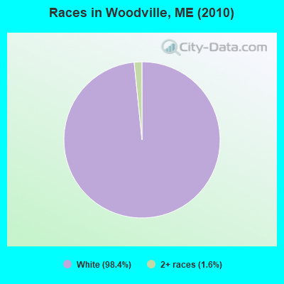
- 24498.4%White alone
- 41.6%Two or more races
Races in Woodville detailed stats: ancestries, foreign born residents, place of birth
 Recent articles from our blog. Our writers, many of them Ph.D. graduates or candidates, create easy-to-read articles on a wide variety of topics.
Ancestries: United States (37.4%), French (13.3%), Irish (8.7%), English (8.0%), French Canadian (3.8%), German (3.5%).
Current Local Time: EST time zone
Incorporated on 02/28/1895
Land area: 42.9 square miles.
Population density: 5.8 people per square mile (very low).
3 residents are foreign born
| This town: | 1.0% |
| Maine: | 2.9% |
| Woodville town: | 1.1% ($750) |
| Maine: | 1.5% ($1,417) |
Nearest city with pop. 50,000+: Portland, ME  (155.6 miles , pop. 64,249).
Nearest city with pop. 200,000+: Boston, MA (256.4 miles , pop. 589,141).
Nearest city with pop. 1,000,000+: Bronx, NY (422.5 miles , pop. 1,332,650).
Nearest cities:
), ), ), ), )Latitude: 45.50 N, Longitude: 68.44 W
Area code commonly used in this area: 207
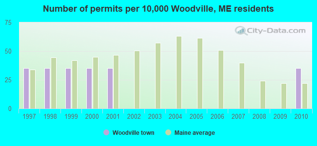
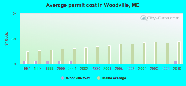
Single-family new house construction building permits:
- 2010: 1 building, cost: $25,000
- 2001: 1 building, cost: $22,000
- 2000: 1 building, cost: $22,000
- 1999: 1 building, cost: $22,000
- 1998: 1 building, cost: $22,000
- 1997: 1 building, cost: $22,000
| Here: | 7.3% |
| Maine: | 3.4% |

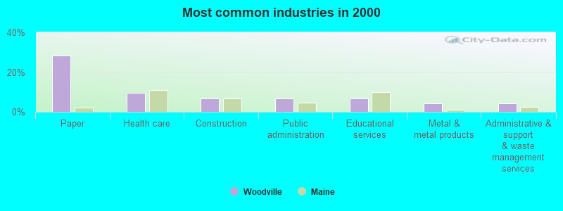
- Paper (28.4%)
- Health care (9.5%)
- Construction (6.9%)
- Public administration (6.9%)
- Educational services (6.9%)
- Metal & metal products (4.3%)
- Administrative & support & waste management services (4.3%)
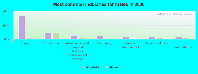
- Paper (41.4%)
- Construction (11.4%)
- Administrative & support & waste management services (7.1%)
- Machinery (5.7%)
- Metal & metal products (4.3%)
- Wood products (4.3%)
- Truck transportation (4.3%)
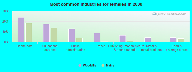
- Health care (23.9%)
- Educational services (17.4%)
- Public administration (13.0%)
- Paper (8.7%)
- Publishing, motion picture & sound recording industries (6.5%)
- Metal & metal products (4.3%)
- Food & beverage stores (4.3%)
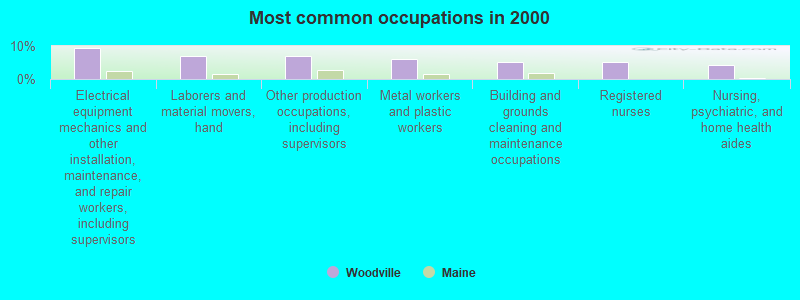
- Electrical equipment mechanics and other installation, maintenance, and repair workers, including supervisors (9.5%)
- Laborers and material movers, hand (6.9%)
- Other production occupations, including supervisors (6.9%)
- Metal workers and plastic workers (6.0%)
- Building and grounds cleaning and maintenance occupations (5.2%)
- Registered nurses (5.2%)
- Nursing, psychiatric, and home health aides (4.3%)
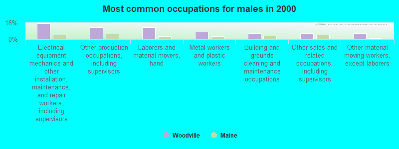
- Electrical equipment mechanics and other installation, maintenance, and repair workers, including supervisors (15.7%)
- Other production occupations, including supervisors (11.4%)
- Laborers and material movers, hand (11.4%)
- Metal workers and plastic workers (7.1%)
- Building and grounds cleaning and maintenance occupations (5.7%)
- Other sales and related occupations, including supervisors (5.7%)
- Other material moving workers, except laborers (5.7%)

- Registered nurses (13.0%)
- Nursing, psychiatric, and home health aides (10.9%)
- Other office and administrative support workers, including supervisors (8.7%)
- Media and communications workers (6.5%)
- Information and record clerks, except customer service representatives (4.3%)
- Cooks and food preparation workers (4.3%)
- Building and grounds cleaning and maintenance occupations (4.3%)
Average climate in Woodville, Maine
Based on data reported by over 4,000 weather stations


Earthquake activity:
Woodville-area historical earthquake activity is significantly above Maine state average. It is 83% smaller than the overall U.S. average.On 4/20/2002 at 10:50:47, a magnitude 5.3 (5.3 ML, Depth: 3.0 mi, Class: Moderate, Intensity: VI - VII) earthquake occurred 265.9 miles away from Woodville center
On 4/20/2002 at 10:50:47, a magnitude 5.2 (5.2 MB, 4.2 MS, 5.2 MW, 5.0 MW) earthquake occurred 267.3 miles away from Woodville center
On 10/16/2012 at 23:12:25, a magnitude 4.7 (4.7 ML, Depth: 10.0 mi, Class: Light, Intensity: IV - V) earthquake occurred 171.0 miles away from Woodville center
On 10/7/1983 at 10:18:46, a magnitude 5.3 (5.1 MB, 5.3 LG, 5.1 ML) earthquake occurred 309.0 miles away from the city center
On 1/19/1982 at 00:14:42, a magnitude 4.7 (4.5 MB, 4.7 MD, 4.5 LG) earthquake occurred 208.4 miles away from Woodville center
On 9/16/1994 at 04:22:42, a magnitude 3.6 (3.6 LG, Depth: 3.1 mi, Class: Light, Intensity: II - III) earthquake occurred 17.2 miles away from Woodville center
Magnitude types: regional Lg-wave magnitude (LG), body-wave magnitude (MB), duration magnitude (MD), local magnitude (ML), surface-wave magnitude (MS), moment magnitude (MW)
Natural disasters:
The number of natural disasters in Penobscot County (19) is greater than the US average (15).Major Disasters (Presidential) Declared: 11
Emergencies Declared: 7
Causes of natural disasters: Floods: 9, Storms: 8, Snows: 5, Heavy Rains: 2, Blizzard: 1, Hurricane: 1, Ice Storm: 1, Snowfall: 1, Wind: 1, Winter Storm: 1, Other: 2 (Note: some incidents may be assigned to more than one category).
Colleges/universities with over 2000 students nearest to Woodville:
- University of Maine (about 44 miles; Orono, ME; Full-time enrollment: 8,931)
- Husson University (about 50 miles; Bangor, ME; FT enrollment: 2,421)
- University of Maine at Farmington (about 102 miles; Farmington, ME; FT enrollment: 2,036)
- University of Maine at Augusta (about 105 miles; Augusta, ME; FT enrollment: 3,204)
- Saint Joseph's College of Maine (about 154 miles; Standish, ME; FT enrollment: 2,010)
- Southern Maine Community College (about 156 miles; South Portland, ME; FT enrollment: 4,666)
- University of Southern Maine (about 156 miles; Portland, ME; FT enrollment: 6,647)
Points of interest:
Swamps: Carlisle Swamp (A), Five Bog (B), Inman Bog (C). Display/hide their locations on the map
Streams, rivers, and creeks: Little Ebhorse Stream (A), Rush Brook (B), Meadow Brook (C), Eagle Stream (D), Bear Brook (E). Display/hide their locations on the map
| This town: | 2.5 people |
| Maine: | 2.3 people |
| This town: | 78.0% |
| Whole state: | 62.9% |
| This town: | 4.0% |
| Whole state: | 9.4% |
Likely homosexual households (counted as self-reported same-sex unmarried-partner households)
- Lesbian couples: 0.0% of all households
- Gay men: 1.0% of all households
| This town: | 7.3% |
| Whole state: | 10.9% |
| This town: | 3.6% |
| Whole state: | 4.1% |
For population 15 years and over in Woodville:
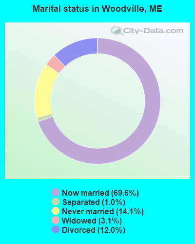
- Never married: 14.1%
- Now married: 69.6%
- Separated: 1.0%
- Widowed: 3.1%
- Divorced: 12.0%
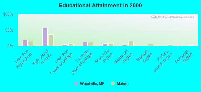
For population 25 years and over in Woodville:
- High school or higher: 81.5%
- Bachelor's degree or higher: 2.4%
- Graduate or professional degree: 0.0%
- Unemployed: 1.7%
- Mean travel time to work (commute): 25.1 minutes
| Here: | 7.4 |
| Maine average: | 11.2 |


Graphs represent county-level data. Detailed 2008 Election Results
Religion statistics for Woodville, ME (based on Penobscot County data)


| Religion | Adherents | Congregations |
|---|---|---|
| Catholic | 16,581 | 15 |
| Mainline Protestant | 9,715 | 59 |
| Evangelical Protestant | 7,523 | 80 |
| Other | 2,936 | 22 |
| Orthodox | 300 | 1 |
| None | 116,868 | - |
Food Environment Statistics:
| Here: | 2.29 / 10,000 pop. |
| Maine: | 2.80 / 10,000 pop. |
| Penobscot County: | 0.13 / 10,000 pop. |
| State: | 0.14 / 10,000 pop. |
| Here: | 2.56 / 10,000 pop. |
| Maine: | 2.20 / 10,000 pop. |
| Here: | 5.72 / 10,000 pop. |
| Maine: | 5.75 / 10,000 pop. |
| Penobscot County: | 7.41 / 10,000 pop. |
| State: | 11.02 / 10,000 pop. |
| Here: | 9.0% |
| State: | 8.2% |
| Penobscot County: | 28.0% |
| State: | 25.0% |
Strongest AM radio stations in Woodville:
- WZON (620 AM; 5 kW; BANGOR, ME; Owner: THE ZONE CORPORATION)
- WSYY (1240 AM; 1 kW; MILLINOCKET, ME; Owner: KATAHDIN BROADCASTING, INC.)
- WABI (910 AM; 5 kW; BANGOR, ME; Owner: CLEAR CHANNEL BROADCASTING LICENSES, INC.)
- WREM (710 AM; daytime; 5 kW; MONTICELLO, ME; Owner: ALLAN H WEINER)
- WSKW (1160 AM; 10 kW; SKOWHEGAN, ME; Owner: MOUNTAIN WIRELESS, INCORPORATED)
- WRKO (680 AM; 50 kW; BOSTON, MA; Owner: ENTERCOM BOSTON LICENSE, LLC)
- WTME (780 AM; 10 kW; RUMFORD, ME; Owner: MOUNTAIN VALLEY BROADCASTING, INC.)
- WEEI (850 AM; 50 kW; BOSTON, MA; Owner: ENTERCOM BOSTON LICENSE, LLC)
- WFST (600 AM; 5 kW; CARIBOU, ME; Owner: NORTHERN BROADCAST MINISTRIES, INC.)
- WBZ (1030 AM; 50 kW; BOSTON, MA; Owner: INFINITY BROADCASTING OPERATIONS, INC.)
- WNNZ (640 AM; 50 kW; WESTFIELD, MA; Owner: CLEAR CHANNEL BROADCASTING LICENSES, INC.)
- WCHP (760 AM; 35 kW; CHAMPLAIN, NY; Owner: CHAMPLAIN RADIO, INC.)
- WCRN (830 AM; 50 kW; WORCESTER, MA; Owner: CARTER BROADCASTING CORPORATION)
Strongest FM radio stations in Woodville:
- WVOM (103.9 FM; HOWLAND, ME; Owner: CLEAR CHANNEL BROADCASTING LICENSES, INC.)
- WHCF (88.5 FM; BANGOR, ME; Owner: BANGOR BAPTIST CHURCH)
- WHMX (105.7 FM; LINCOLN, ME; Owner: BANGOR BAPTIST CHURCH)
- WSYY-FM (94.9 FM; MILLINOCKET, ME; Owner: KATAHDIN COMMUNICATIONS, INC.)
TV broadcast stations around Woodville:
- W34CN (Channel 34; MEDWAY, ME; Owner: TRINITY BROADCASTING NETWORK)
FCC Registered Antenna Towers:
8 (See the full list of FCC Registered Antenna Towers in Woodville)FCC Registered Microwave Towers:
1- Woodville, 51 Glidden Lane (#284992) (Lat: 45.476000 Lon: -68.491694), Type: Ltower, Structure height: 76.5 m, Overall height: 78 m, Call Sign: WQXS909,
Assigned Frequencies: 11225.0 MHz, 11385.0 MHz, 11225.0 MHz, 11385.0 MHz, 11225.0 MHz, 11385.0 MHz, 11225.0 MHz, 11385.0 MHz, 11225.0 MHz, 11385.0 MHz... (+8 more), Grant Date: 05/31/2016, Expiration Date: 05/31/2026, Cancellation Date: 09/17/2020, Certifier: Jessica B Lyons, Registrant: At&t Services, Inc., 208 S. Akard St., Room 2100, Dallas, TX 75202, Phone: (855) 699-7073, Email:
FAA Registered Aircraft:
1- Aircraft: PIPER J3C-65 (Category: Land, Seats: 2, Weight: Up to 12,499 Pounds, Speed: 67 mph), Engine: CONT MOTOR A&C65 SERIES (65 HP) (Reciprocating)
N-Number: 92439, N92439, N-92439, Serial Number: 16906, Year manufactured: 1946, Airworthiness Date: 11/23/1955, Certificate Issue Date: 08/10/1987
Registrant (Individual): Walter V Goodine, 1497 Woodville Rd, Woodville, ME 04457
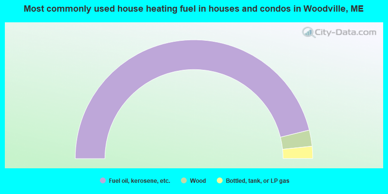
- 92.3%Fuel oil, kerosene, etc.
- 4.4%Wood
- 3.3%Bottled, tank, or LP gas
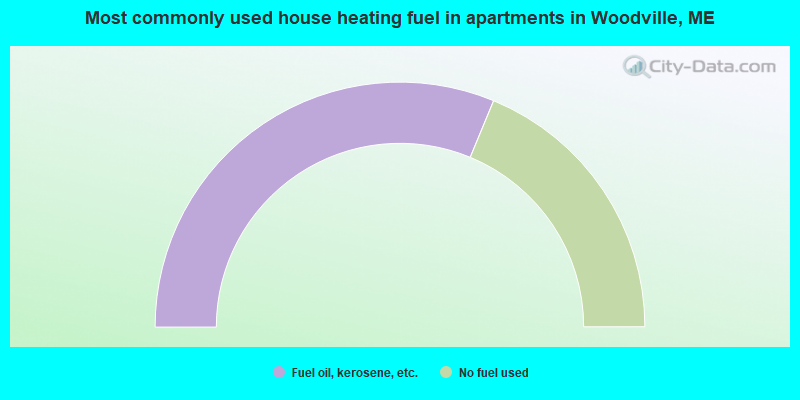
- 62.5%Fuel oil, kerosene, etc.
- 37.5%No fuel used
Woodville compared to Maine state average:
- Median house value below state average.
- Unemployed percentage significantly below state average.
- Black race population percentage significantly below state average.
- Hispanic race population percentage significantly below state average.
- Foreign-born population percentage significantly below state average.
- Renting percentage significantly below state average.
- Length of stay since moving in significantly above state average.
- Number of rooms per house significantly below state average.
- House age significantly below state average.
- Percentage of population with a bachelor's degree or higher significantly below state average.