Medway, Maine


Submit your own pictures of this town and show them to the world
- OSM Map
- General Map
- Google Map
- MSN Map
Population change since 2000: -9.4%
 |
| Males: 670 | |
| Females: 679 |
| Median resident age: | 47.8 years |
| Maine median age: | 43.0 years |
Zip codes: 04460.
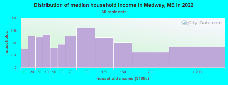
| Medway: | $60,014 |
| ME: | $69,543 |
Estimated per capita income in 2022: $30,685 (it was $15,264 in 2000)
Medway town income, earnings, and wages data
Estimated median house or condo value in 2022: $128,802 (it was $49,500 in 2000)
| Medway: | $128,802 |
| ME: | $290,600 |
Mean prices in 2022: all housing units: $235,563; detached houses: $252,705; townhouses or other attached units: $267,749; in 2-unit structures: $255,332; in 3-to-4-unit structures: $815,300; in 5-or-more-unit structures: $185,873; mobile homes: $93,017; occupied boats, rvs, vans, etc.: $21,333
Detailed information about poverty and poor residents in Medway, ME
Compare current foreclosures near Medway, ME:
| Photo | Address | Area | Beds / Baths | Price | Details |
|---|---|---|---|---|---|

|
#1
Pea Ridge Rd
Lincoln, ME 04457
|
- sq. feet
|
- baths - beds |
show details | |

|
#2
Elm St
East Millinocket, ME 04430
|
- sq. feet
|
- baths - beds |
show details | |

|
#3
Central St
Millinocket, ME 04462
|
- sq. feet
|
- baths - beds |
show details | |

|
#4
Vermont St
Millinocket, ME 04462
|
- sq. feet
|
- baths - beds |
show details | |

|
#5
Knox St
Millinocket, ME 04462
|
- sq. feet
|
- baths - beds |
show details | |

|
Check over 1 million property listings on Foreclosure.com!
|
browse all offers | |||

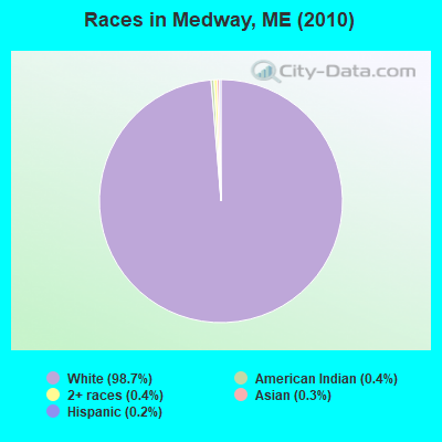
- 1,33198.7%White alone
- 50.4%American Indian alone
- 50.4%Two or more races
- 40.3%Asian alone
- 30.2%Hispanic
- 10.07%Black alone
Races in Medway detailed stats: ancestries, foreign born residents, place of birth
According to our research of Maine and other state lists, there were 4 registered sex offenders living in Medway, Maine as of May 08, 2024.
The ratio of all residents to sex offenders in Medway is 337 to 1.
 Recent articles from our blog. Our writers, many of them Ph.D. graduates or candidates, create easy-to-read articles on a wide variety of topics.

 | Certificate of Occupancy in rural northern Maine (26 replies) |
| Relocating to the Northern Maine area (10 replies) |
| Current COVID conditions in Maine (12 replies) |
| "The 18 Essential Maine Restaurants" (13 replies) |
| Maine for a new home? (27 replies) |
| Maine Demographics (36 replies) |
Latest news from Medway, ME collected exclusively by city-data.com from local newspapers, TV, and radio stations
Ancestries: United States (23.3%), French (18.0%), English (16.1%), Irish (13.6%), French Canadian (4.3%), Scotch-Irish (2.9%).
Current Local Time: EST time zone
Incorporated on 02/08/1875
Elevation: 296 feet
Land area: 41.0 square miles.
Population density: 33 people per square mile (very low).
22 residents are foreign born
| This town: | 1.5% |
| Maine: | 2.9% |
| Medway town: | 2.1% ($1,022) |
| Maine: | 1.5% ($1,417) |
Nearest city with pop. 50,000+: Portland, ME  (159.2 miles , pop. 64,249).
Nearest city with pop. 200,000+: Boston, MA (260.4 miles , pop. 589,141).
Nearest city with pop. 1,000,000+: Bronx, NY (425.2 miles , pop. 1,332,650).
Nearest cities:
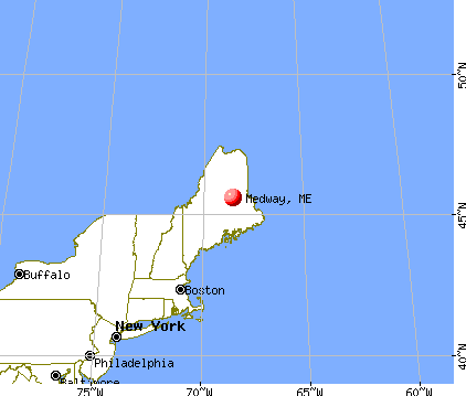
), ), ), ), ), Latitude: 45.60 N, Longitude: 68.52 W
Area code commonly used in this area: 207

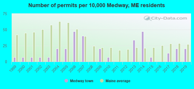
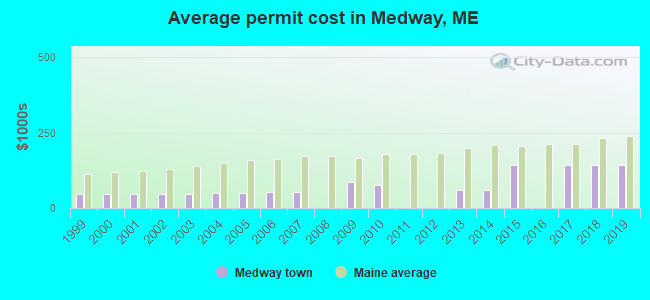
Single-family new house construction building permits:
- 2019: 3 buildings, average cost: $142,500
- 2018: 3 buildings, average cost: $142,500
- 2017: 2 buildings, average cost: $142,500
- 2015: 1 building, cost: $142,000
- 2014: 7 buildings, average cost: $59,000
- 2013: 5 buildings, average cost: $59,000
- 2010: 1 building, cost: $75,000
- 2009: 3 buildings, average cost: $86,700
- 2007: 6 buildings, average cost: $52,900
- 2006: 7 buildings, average cost: $52,900
- 2005: 3 buildings, average cost: $50,000
- 2004: 3 buildings, average cost: $50,000
- 2003: 1 building, cost: $48,000
- 2002: 1 building, cost: $48,000
- 2001: 1 building, cost: $48,000
- 2000: 1 building, cost: $48,000
- 1999: 1 building, cost: $48,000
| Here: | 8.8% |
| Maine: | 3.4% |


- Paper (29.4%)
- Health care (8.4%)
- Construction (7.9%)
- Educational services (6.9%)
- Agriculture, forestry, fishing & hunting (6.1%)
- Accommodation & food services (5.3%)
- Food & beverage stores (4.4%)

- Paper (46.6%)
- Construction (11.7%)
- Agriculture, forestry, fishing & hunting (7.6%)
- Truck transportation (4.1%)
- Repair & maintenance (3.5%)
- Wood products (2.7%)
- Administrative & support & waste management services (2.2%)

- Health care (20.5%)
- Educational services (15.1%)
- Accommodation & food services (11.3%)
- Food & beverage stores (9.6%)
- Social assistance (6.3%)
- Agriculture, forestry, fishing & hunting (3.8%)
- Department & other general merchandise stores (3.3%)
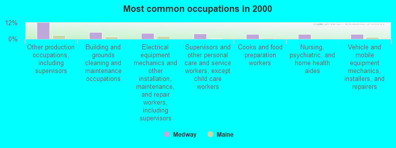
- Other production occupations, including supervisors (11.8%)
- Building and grounds cleaning and maintenance occupations (4.9%)
- Electrical equipment mechanics and other installation, maintenance, and repair workers, including supervisors (4.3%)
- Supervisors and other personal care and service workers, except child care workers (3.9%)
- Cooks and food preparation workers (3.8%)
- Nursing, psychiatric, and home health aides (3.6%)
- Vehicle and mobile equipment mechanics, installers, and repairers (3.6%)
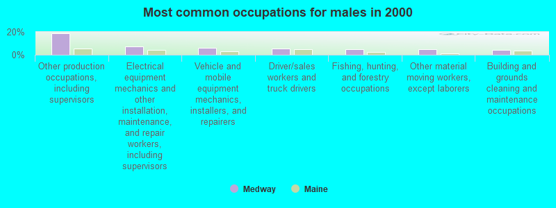
- Other production occupations, including supervisors (19.0%)
- Electrical equipment mechanics and other installation, maintenance, and repair workers, including supervisors (7.0%)
- Vehicle and mobile equipment mechanics, installers, and repairers (6.0%)
- Driver/sales workers and truck drivers (5.7%)
- Fishing, hunting, and forestry occupations (5.1%)
- Other material moving workers, except laborers (4.6%)
- Building and grounds cleaning and maintenance occupations (4.1%)

- Supervisors and other personal care and service workers, except child care workers (8.8%)
- Nursing, psychiatric, and home health aides (8.4%)
- Cooks and food preparation workers (7.5%)
- Cashiers (7.1%)
- Bookkeeping, accounting, and auditing clerks (6.7%)
- Building and grounds cleaning and maintenance occupations (6.3%)
- Preschool, kindergarten, elementary, and middle school teachers (5.4%)
Average climate in Medway, Maine
Based on data reported by over 4,000 weather stations


Earthquake activity:
Medway-area historical earthquake activity is significantly above Maine state average. It is 83% smaller than the overall U.S. average.On 4/20/2002 at 10:50:47, a magnitude 5.3 (5.3 ML, Depth: 3.0 mi, Class: Moderate, Intensity: VI - VII) earthquake occurred 263.8 miles away from Medway center
On 4/20/2002 at 10:50:47, a magnitude 5.2 (5.2 MB, 4.2 MS, 5.2 MW, 5.0 MW) earthquake occurred 265.3 miles away from the city center
On 10/16/2012 at 23:12:25, a magnitude 4.7 (4.7 ML, Depth: 10.0 mi, Class: Light, Intensity: IV - V) earthquake occurred 174.0 miles away from Medway center
On 10/7/1983 at 10:18:46, a magnitude 5.3 (5.1 MB, 5.3 LG, 5.1 ML) earthquake occurred 307.6 miles away from Medway center
On 1/19/1982 at 00:14:42, a magnitude 4.7 (4.5 MB, 4.7 MD, 4.5 LG) earthquake occurred 210.1 miles away from the city center
On 9/16/1994 at 04:22:42, a magnitude 3.6 (3.6 LG, Depth: 3.1 mi, Class: Light, Intensity: II - III) earthquake occurred 25.2 miles away from Medway center
Magnitude types: regional Lg-wave magnitude (LG), body-wave magnitude (MB), duration magnitude (MD), local magnitude (ML), surface-wave magnitude (MS), moment magnitude (MW)
Natural disasters:
The number of natural disasters in Penobscot County (19) is greater than the US average (15).Major Disasters (Presidential) Declared: 11
Emergencies Declared: 7
Causes of natural disasters: Floods: 9, Storms: 8, Snows: 5, Heavy Rains: 2, Blizzard: 1, Hurricane: 1, Ice Storm: 1, Snowfall: 1, Wind: 1, Winter Storm: 1, Other: 2 (Note: some incidents may be assigned to more than one category).
Colleges/universities with over 2000 students nearest to Medway:
- University of Maine (about 50 miles; Orono, ME; Full-time enrollment: 8,931)
- Husson University (about 56 miles; Bangor, ME; FT enrollment: 2,421)
- University of Maine at Farmington (about 103 miles; Farmington, ME; FT enrollment: 2,036)
- University of Maine at Augusta (about 108 miles; Augusta, ME; FT enrollment: 3,204)
- Saint Joseph's College of Maine (about 157 miles; Standish, ME; FT enrollment: 2,010)
- Southern Maine Community College (about 160 miles; South Portland, ME; FT enrollment: 4,666)
- University of Southern Maine (about 160 miles; Portland, ME; FT enrollment: 6,647)
Public elementary/middle school in Medway:
- MEDWAY MIDDLE SCHOOL (Location: 25 MIDDLE SCHOOL DRIVE, Grades: 5-8)
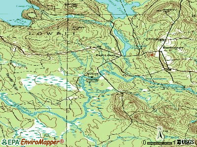
Points of interest:
Notable locations in Medway: Katahdin Shadows Campground (A), Medway Volunteer Fire Department (B). Display/hide their locations on the map
Church in Medway: Bethel Church (A). Display/hide its location on the map
Cemetery: Fiske Cemetery (1). Display/hide its location on the map
Reservoir: West Branch Penobscot River Reservoir (A). Display/hide its location on the map
Streams, rivers, and creeks: Baker Brook (A), Tots Brook (B), West Branch Penobscot River (C), Rockabema Stream (D), Hathaway Brook (E), East Branch Penobscot River (F), Little Salmon Stream (G), Little Pattagumpus Stream (H). Display/hide their locations on the map
Drinking water stations with addresses in Medway and their reported violations in the past:
COUNTRY DINER (Population served: 270, Groundwater):Past health violations:PEGGYS BAR & GRILL (Population served: 96, Groundwater):Past monitoring violations:
- MCL, Monthly (TCR) - In MAY-2010, Contaminant: Coliform. Follow-up actions: St Public Notif requested (MAY-27-2010), St Formal NOV issued (MAY-27-2010), St Compliance achieved (AUG-26-2011), St Public Notif received (MAR-26-2012)
- 4 routine major monitoring violations
- One regular monitoring violation
Past health violations:GATEWAY INN (Population served: 76, Groundwater):Past monitoring violations:
- MCL, Monthly (TCR) - In JUL-2010, Contaminant: Coliform. Follow-up actions: St Public Notif requested (AUG-10-2010), St Formal NOV issued (AUG-10-2010), St Compliance achieved (AUG-31-2010), St Public Notif received (JUN-05-2014), St Site Visit (enforcement) (JUN-05-2014)
- MCL, Monthly (TCR) - In OCT-2007, Contaminant: Coliform. Follow-up actions: St Formal NOV issued (OCT-09-2007), St Public Notif requested (OCT-09-2007), St Public Notif received (NOV-01-2007), St Compliance achieved (SEP-08-2011), St Intentional no-action (SEP-09-2011)
- MCL, Monthly (TCR) - In JAN-2007, Contaminant: Coliform. Follow-up actions: St Violation/Reminder Notice (JAN-25-2007), St Public Notif requested (JAN-25-2007), St Compliance achieved (DEC-28-2007), St Public Notif received (JUN-05-2014), St Site Visit (enforcement) (JUN-05-2014)
- 13 routine major monitoring violations
- One regular monitoring violation
Past health violations:THE SCOTTS COMPANY (Population served: 31, Groundwater):Past monitoring violations:
- MCL, Monthly (TCR) - In FEB-2007, Contaminant: Coliform. Follow-up actions: St Violation/Reminder Notice (FEB-16-2007), St Public Notif requested (FEB-16-2007), St AO (w/o penalty) issued (MAY-31-2007), St Public Notif received (JUN-13-2007), St AO (w/o penalty) issued (DEC-19-2008), St Intentional no-action (SEP-09-2011), St Compliance achieved (SEP-09-2011)
- MCL, Monthly (TCR) - In JAN-2007, Contaminant: Coliform. Follow-up actions: St Violation/Reminder Notice (FEB-07-2007), St Public Notif requested (FEB-07-2007), St AO (w/o penalty) issued (MAY-31-2007), St Public Notif received (JUN-13-2007), St AO (w/o penalty) issued (DEC-19-2008), St Compliance achieved (SEP-07-2011), St Intentional no-action (SEP-09-2011)
- MCL, Monthly (TCR) - In NOV-2006, Contaminant: Coliform. Follow-up actions: St Violation/Reminder Notice (NOV-16-2006), St Public Notif requested (NOV-16-2006), St AO (w/o penalty) issued (MAY-31-2007), St Public Notif received (JUN-13-2007), St AO (w/o penalty) issued (DEC-19-2008), St Compliance achieved (SEP-07-2011), St Intentional no-action (SEP-09-2011)
- MCL, Monthly (TCR) - In NOV-2005, Contaminant: Coliform. Follow-up actions: St Public Notif requested (DEC-08-2005), St Violation/Reminder Notice (DEC-08-2005), St Compliance achieved (JUN-20-2006), St AO (w/o penalty) issued (MAY-31-2007), St Public Notif received (JUN-13-2007), St AO (w/o penalty) issued (DEC-19-2008)
- MCL, Monthly (TCR) - In OCT-2005, Contaminant: Coliform. Follow-up actions: St Violation/Reminder Notice (NOV-04-2005), St Public Notif requested (NOV-04-2005), St Compliance achieved (JUN-20-2006), St AO (w/o penalty) issued (MAY-31-2007), St Public Notif received (JUN-13-2007), St AO (w/o penalty) issued (DEC-19-2008)
- Monitoring, Repeat Major (TCR) - In APR-2007, Contaminant: Coliform (TCR). Follow-up actions: St Public Notif requested (MAY-02-2007), St Violation/Reminder Notice (MAY-02-2007), St AO (w/o penalty) issued (MAY-31-2007), St Public Notif received (JUN-13-2007), St AO (w/o penalty) issued (DEC-19-2008), St Compliance achieved (AUG-17-2011)
- Monitoring, Repeat Major (TCR) - In MAR-2007, Contaminant: Coliform (TCR). Follow-up actions: St Public Notif requested (APR-11-2007), St Violation/Reminder Notice (APR-11-2007), St AO (w/o penalty) issued (MAY-31-2007), St Public Notif received (JUN-13-2007), St AO (w/o penalty) issued (DEC-19-2008), St Compliance achieved (AUG-17-2011)
- Monitoring, Repeat Major (TCR) - In DEC-2006, Contaminant: Coliform (TCR). Follow-up actions: St Public Notif requested (JAN-11-2007), St Violation/Reminder Notice (JAN-11-2007), St AO (w/o penalty) issued (MAY-31-2007), St Public Notif received (JUN-13-2007), St AO (w/o penalty) issued (DEC-19-2008), St Compliance achieved (AUG-17-2011)
- 4 routine major monitoring violations
- One minor monitoring violation
Past monitoring violations:
- 4 routine major monitoring violations
Drinking water stations with addresses in Medway that have no violations reported:
- KATAHDIN SHADOWS CMPGRD (Population served: 250, Primary Water Source Type: Groundwater)
| This town: | 2.3 people |
| Maine: | 2.3 people |
| This town: | 69.4% |
| Whole state: | 62.9% |
| This town: | 8.7% |
| Whole state: | 9.4% |
Likely homosexual households (counted as self-reported same-sex unmarried-partner households)
- Lesbian couples: 0.2% of all households
- Gay men: 0.5% of all households
| This town: | 11.5% |
| Whole state: | 10.9% |
| This town: | 5.9% |
| Whole state: | 4.1% |
For population 15 years and over in Medway:
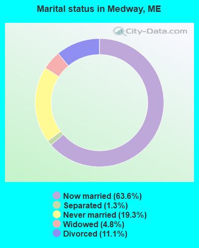
- Never married: 19.3%
- Now married: 63.6%
- Separated: 1.3%
- Widowed: 4.8%
- Divorced: 11.1%
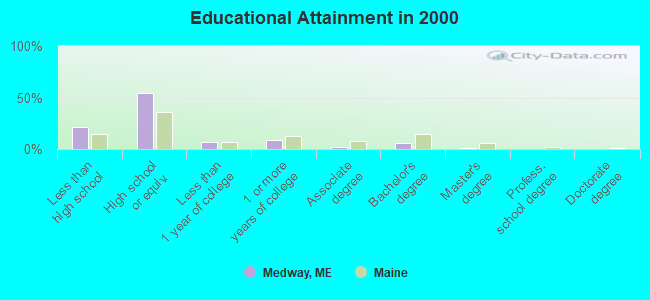
For population 25 years and over in Medway:
- High school or higher: 78.6%
- Bachelor's degree or higher: 6.8%
- Graduate or professional degree: 1.4%
- Unemployed: 5.6%
- Mean travel time to work (commute): 19.1 minutes
| Here: | 8.7 |
| Maine average: | 11.2 |


Graphs represent county-level data. Detailed 2008 Election Results
Religion statistics for Medway, ME (based on Penobscot County data)


| Religion | Adherents | Congregations |
|---|---|---|
| Catholic | 16,581 | 15 |
| Mainline Protestant | 9,715 | 59 |
| Evangelical Protestant | 7,523 | 80 |
| Other | 2,936 | 22 |
| Orthodox | 300 | 1 |
| None | 116,868 | - |
Food Environment Statistics:
| Here: | 2.29 / 10,000 pop. |
| Maine: | 2.80 / 10,000 pop. |
| Penobscot County: | 0.13 / 10,000 pop. |
| State: | 0.14 / 10,000 pop. |
| Here: | 2.56 / 10,000 pop. |
| State: | 2.20 / 10,000 pop. |
| This county: | 5.72 / 10,000 pop. |
| State: | 5.75 / 10,000 pop. |
| This county: | 7.41 / 10,000 pop. |
| State: | 11.02 / 10,000 pop. |
| Here: | 9.0% |
| Maine: | 8.2% |
| Penobscot County: | 28.0% |
| State: | 25.0% |
Businesses in Medway, ME
- Circle K: 1
- U-Haul: 1
Strongest AM radio stations in Medway:
- WSYY (1240 AM; 1 kW; MILLINOCKET, ME; Owner: KATAHDIN BROADCASTING, INC.)
- WZON (620 AM; 5 kW; BANGOR, ME; Owner: THE ZONE CORPORATION)
- WREM (710 AM; daytime; 5 kW; MONTICELLO, ME; Owner: ALLAN H WEINER)
- WABI (910 AM; 5 kW; BANGOR, ME; Owner: CLEAR CHANNEL BROADCASTING LICENSES, INC.)
- WSKW (1160 AM; 10 kW; SKOWHEGAN, ME; Owner: MOUNTAIN WIRELESS, INCORPORATED)
- WRKO (680 AM; 50 kW; BOSTON, MA; Owner: ENTERCOM BOSTON LICENSE, LLC)
- WFST (600 AM; 5 kW; CARIBOU, ME; Owner: NORTHERN BROADCAST MINISTRIES, INC.)
- WTME (780 AM; 10 kW; RUMFORD, ME; Owner: MOUNTAIN VALLEY BROADCASTING, INC.)
- WEEI (850 AM; 50 kW; BOSTON, MA; Owner: ENTERCOM BOSTON LICENSE, LLC)
- WCHP (760 AM; 35 kW; CHAMPLAIN, NY; Owner: CHAMPLAIN RADIO, INC.)
- WNNZ (640 AM; 50 kW; WESTFIELD, MA; Owner: CLEAR CHANNEL BROADCASTING LICENSES, INC.)
- WBZ (1030 AM; 50 kW; BOSTON, MA; Owner: INFINITY BROADCASTING OPERATIONS, INC.)
- WCRN (830 AM; 50 kW; WORCESTER, MA; Owner: CARTER BROADCASTING CORPORATION)
Strongest FM radio stations in Medway:
- WSYY-FM (94.9 FM; MILLINOCKET, ME; Owner: KATAHDIN COMMUNICATIONS, INC.)
- WVOM (103.9 FM; HOWLAND, ME; Owner: CLEAR CHANNEL BROADCASTING LICENSES, INC.)
- WHCF (88.5 FM; BANGOR, ME; Owner: BANGOR BAPTIST CHURCH)
- WHMX (105.7 FM; LINCOLN, ME; Owner: BANGOR BAPTIST CHURCH)
TV broadcast stations around Medway:
- W34CN (Channel 34; MEDWAY, ME; Owner: TRINITY BROADCASTING NETWORK)
- Medway, Maine
- Fatal accident count10
- Vehicles involved in fatal accidents14
- Fatal accidents involving drunk persons:3
- Fatalities10
- Persons involved in fatal accidents21
- Pedestrians involved in fatal accidents1
- Maine average
- Fatal accident count1543
- Vehicles involved in fatal accidents2223
- Fatal accidents involving drunk persons553
- Fatalities1683
- Persons involved in fatal accidents3501
- Pedestrians involved in fatal accidents196
- National Bridge Inventory (NBI) Statistics
- 10Number of bridges
- 394ft / 120mTotal length
- 28,945Total average daily traffic
- 1,444Total average daily truck traffic
- 40,836Total future (year 2036) average daily traffic
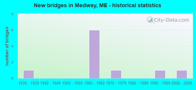
- New bridges - historical statistics
- 11930-1939
- 61960-1969
- 11970-1979
- 11990-1999
- 12000-2009
FCC Registered Cell Phone Towers:
1 (See the full list of FCC Registered Cell Phone Towers in Medway)FCC Registered Antenna Towers:
16 (See the full list of FCC Registered Antenna Towers)FCC Registered Broadcast Land Mobile Towers:
2- 2.5 Miles South (Lat: 45.574028 Lon: -68.519889), Type: Gtower, Structure height: 54.9 m, Overall height: 60.4 m, Call Sign: WNYQ783,
Assigned Frequencies: 464.850 MHz, Grant Date: 11/15/2017, Expiration Date: 02/11/2028, Registrant: Atlantic Communications, Inc., 40 Freedom Parkway, Hermon, Maine 04401, Bangor, ME 04402-0596, Phone: (207) 848-7590, Fax: (207) 974-3151, Email:
- 2.5 Mi S (Lat: 45.573667 Lon: -68.518917), Call Sign: KNDR342, Licensee ID: L00057935,
Assigned Frequencies: 154.625 MHz, Grant Date: 06/13/1997, Expiration Date: 09/01/2002, Cancellation Date: 01/12/2003, Registrant: Thompsons Forestry Products Inc, Lincoln, ME 04457, Phone: (207) 794-6101
FCC Registered Microwave Towers:
4- STATION, 3.5 Mi From Jct Of Rt 116 And 157 (Lat: 45.573639 Lon: -68.518917), Overall height: 96 m, Call Sign: WNTB388,
Assigned Frequencies: 2189.60 MHz, 6182.40 MHz, 6241.70 MHz, Grant Date: 06/13/1995, Expiration Date: 06/13/2000, Cancellation Date: 09/24/2000, Phone: (207) 848-4242
- MEDWAY, 2.5 Mi S (Lat: 45.573611 Lon: -68.518889), Type: Tower, Structure height: 96 m, Call Sign: WQKH687,
Assigned Frequencies: 942.775 MHz, Grant Date: 04/24/2019, Expiration Date: 05/22/2029, Certifier: Tom Robertson, Registrant: Shulman, Rogers, Gandal, Pordy & Ecker, P.A., 11921 Rockville Pike, 3rd Floor, Rockville, MD 20852, Phone: (301) 255-0553, Fax: (301) 230-2891
- Medway, 2.5 Mi S (Lat: 45.573611 Lon: -68.518889), Type: Gtower, Structure height: 96 m, Call Sign: WQTU420,
Assigned Frequencies: 10815.0 MHz, 10775.0 MHz, 10815.0 MHz, 10775.0 MHz, 10815.0 MHz, 10775.0 MHz, 10815.0 MHz, 10775.0 MHz, 10815.0 MHz, 10775.0 MHz... (+26 more), Grant Date: 04/15/2014, Expiration Date: 04/15/2024, Cancellation Date: 03/13/2019, Certifier: Jessica B Lyons, Registrant: At&t Mobility LLC, 1120 20th Street, Nw, Suite 1000, Washington, DC 20036, Phone: (202) 457-2055, Email:
- Medway, Turnpike Rd (Lat: 45.573556 Lon: -68.521528), Type: Ltower, Structure height: 58.2 m, Overall height: 58.4 m, Call Sign: WQXT470,
Assigned Frequencies: 10735.0 MHz, 10735.0 MHz, 10735.0 MHz, 10735.0 MHz, 10735.0 MHz, 10735.0 MHz, 10735.0 MHz, 10735.0 MHz, 10735.0 MHz, 10815.0 MHz... (+8 more), Grant Date: 06/03/2016, Expiration Date: 06/03/2026, Cancellation Date: 10/22/2020, Certifier: Jessica B Lyons, Registrant: At&t Services, Inc., 208 S. Akard St., Room 2100, Dallas, TX 75202, Phone: (855) 699-7073, Email:
FCC Registered Amateur Radio Licenses:
10 (See the full list of FCC Registered Amateur Radio Licenses in Medway)FAA Registered Aircraft:
4- Aircraft: BELLANCA 7GCBC (Category: Land, Seats: 2, Weight: Up to 12,499 Pounds, Speed: 90 mph), Engine: LYCOMING 0-320 SERIES (180 HP) (Reciprocating)
N-Number: 11689, N11689, N-11689, Serial Number: 354-72, Airworthiness Date: 05/19/1972, Certificate Issue Date: 09/20/2018
Registrant (Individual): Jay Mclaughlin, Po Box 637, Medway, ME 04460 - Aircraft: PALMER WADE CUB (Category: Land, Seats: 2, Weight: Up to 12,499 Pounds), Engine: LYCOMING 0-320 SERIES (180 HP) (Reciprocating)
N-Number: 121WP, N121WP, N-121WP, Serial Number: 1382, Airworthiness Date: 06/09/2005, Certificate Issue Date: 09/03/2019
Registrant (Individual): Robert W Finlay, 24 Sunrise Ct, Medway, ME 04460 - Aircraft: TAYLORCRAFT BF (Category: Land, Seats: 2, Weight: Up to 12,499 Pounds, Speed: 78 mph), Engine: FRANKLIN 4AC150-50 (50 HP) (Reciprocating)
N-Number: 21222, N21222, N-21222, Serial Number: 1012, Year manufactured: 1938, Airworthiness Date: 03/26/1956, Certificate Issue Date: 01/17/2020
Registrant (Individual): Timothy J Cole, 304 Turnpike Rd, Medway, ME 04460 - Aircraft: CESSNA 172E (Category: Land, Seats: 4, Weight: Up to 12,499 Pounds, Speed: 105 mph), Engine: CONT MOTOR 0-300 SER (145 HP) (Reciprocating)
N-Number: 7789U, N7789U, N-7789U, Serial Number: 17251789, Year manufactured: 1964, Airworthiness Date: 06/30/1964, Certificate Issue Date: 08/26/2016
Registrant (Individual): David A Violette, Po Box 606, Medway, ME 04460
2003 - 2018 National Fire Incident Reporting System (NFIRS) incidents
- Fire incident types reported to NFIRS in Medway, ME
- 5739.0%Structure Fires
- 3926.7%Outside Fires
- 2919.9%Other
- 2114.4%Mobile Property/Vehicle Fires
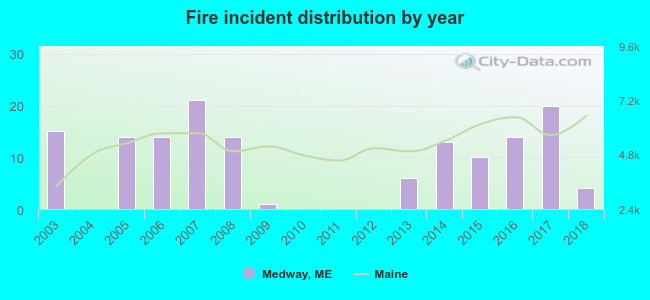 Based on the data from the years 2003 - 2018 the average number of fire incidents per year is 9. The highest number of reported fire incidents - 21 took place in 2007, and the least - 0 in 2004. The data has a dropping trend.
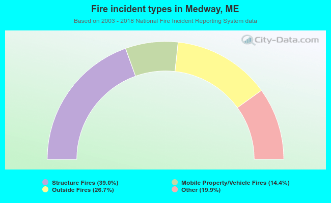 When looking into fire subcategories, the most reports belonged to: Structure Fires (39.0%), and Outside Fires (26.7%).
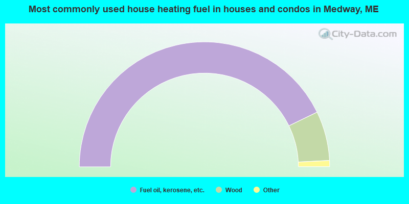
- 85.7%Fuel oil, kerosene, etc.
- 12.8%Wood
- 0.8%Bottled, tank, or LP gas
- 0.8%Electricity
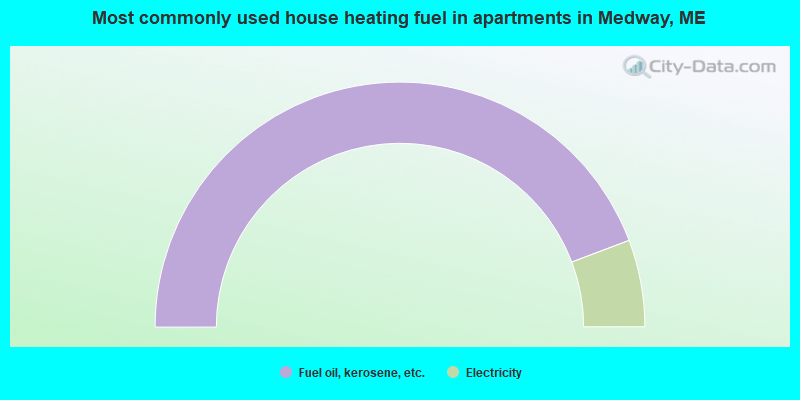
- 88.5%Fuel oil, kerosene, etc.
- 11.5%Electricity
Medway compared to Maine state average:
- Median house value significantly below state average.
- Unemployed percentage below state average.
- Black race population percentage significantly below state average.
- Hispanic race population percentage significantly below state average.
- Median age above state average.
- Foreign-born population percentage significantly below state average.
- Renting percentage significantly below state average.
- Length of stay since moving in significantly above state average.
- Number of rooms per house significantly below state average.
- House age significantly below state average.
- Percentage of population with a bachelor's degree or higher significantly below state average.

|
Total of 1 patent application in 2008-2024.