Windsor, New Hampshire
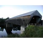
Submit your own pictures of this town and show them to the world
- OSM Map
- Google Map
- MSN Map
Population change since 2000: +11.4%
 |
| Males: 117 | |
| Females: 107 |
| Median resident age: | 45.8 years |
| New Hampshire median age: | 43.9 years |
Zip codes: 03244.
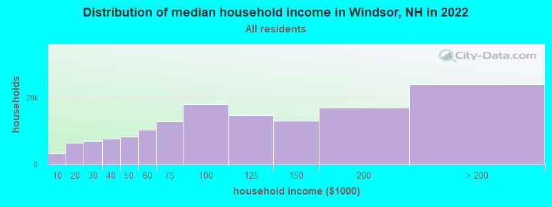
| Windsor: | $83,061 |
| NH: | $89,992 |
Estimated per capita income in 2022: $35,829 (it was $17,966 in 2000)
Windsor town income, earnings, and wages data
Estimated median house or condo value in 2022: $255,627 (it was $85,000 in 2000)
| Windsor: | $255,627 |
| NH: | $384,700 |
Mean prices in 2022: all housing units: $411,252; detached houses: $441,251; townhouses or other attached units: $283,002; in 2-unit structures: $347,377; in 3-to-4-unit structures: $666,663; in 5-or-more-unit structures: $275,798; mobile homes: $132,093
Detailed information about poverty and poor residents in Windsor, NH


- 21395.1%White alone
- 52.2%Two or more races
- 52.2%Hispanic
- 10.4%Asian alone
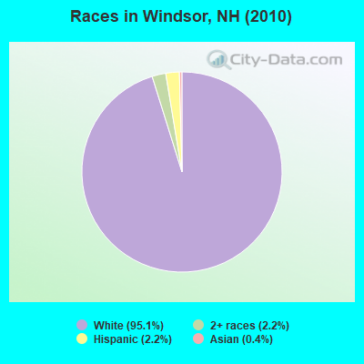
Races in Windsor detailed stats: ancestries, foreign born residents, place of birth
 Recent articles from our blog. Our writers, many of them Ph.D. graduates or candidates, create easy-to-read articles on a wide variety of topics.
Ancestries: Irish (29.4%), French (13.4%), United States (10.4%), French Canadian (5.5%), English (4.5%), Portuguese (4.0%).
Current Local Time: EST time zone
Incorporated in 1798
Land area: 8.34 square miles.
Population density: 27 people per square mile (very low).
3 residents are foreign born
| This town: | 1.5% |
| New Hampshire: | 4.4% |
| Windsor town: | 1.7% ($1,417) |
| New Hampshire: | 2.3% ($2,946) |
Nearest city with pop. 50,000+: Manchester, NH  (30.3 miles , pop. 107,006).
Nearest city with pop. 200,000+: Boston, MA (72.9 miles , pop. 589,141).
Nearest city with pop. 1,000,000+: Bronx, NY (184.0 miles , pop. 1,332,650).
Nearest cities:
), ), ), Latitude: 43.12 N, Longitude: 72.02 W
Area code commonly used in this area: 603
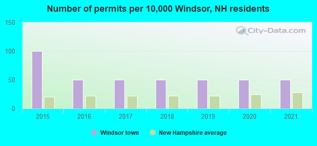
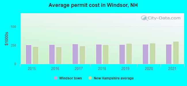
Single-family new house construction building permits:
- 2021: 1 building, cost: $265,300
- 2020: 1 building, cost: $265,300
- 2019: 1 building, cost: $262,400
- 2018: 1 building, cost: $266,000
- 2017: 1 building, cost: $267,800
- 2016: 1 building, cost: $261,800
- 2015: 2 buildings, average cost: $257,200
| Here: | 2.5% |
| New Hampshire: | 2.5% |
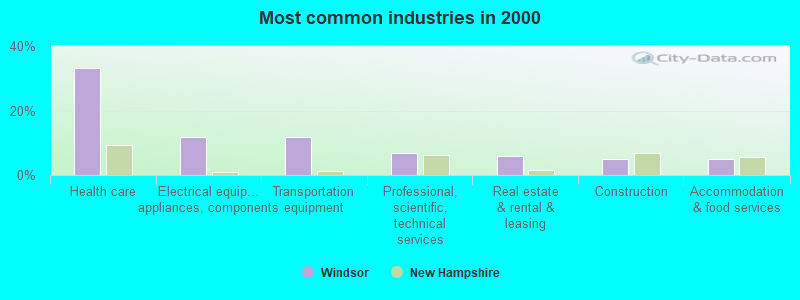
- Health care (33.3%)
- Electrical equipment, appliances, components (11.8%)
- Transportation equipment (11.8%)
- Professional, scientific, technical services (6.9%)
- Real estate & rental & leasing (5.9%)
- Construction (4.9%)
- Accommodation & food services (4.9%)
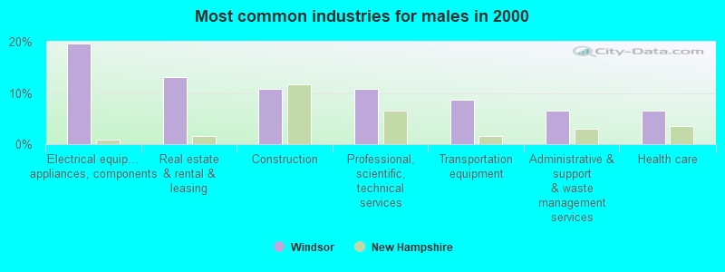
- Electrical equipment, appliances, components (19.6%)
- Real estate & rental & leasing (13.0%)
- Construction (10.9%)
- Professional, scientific, technical services (10.9%)
- Transportation equipment (8.7%)
- Administrative & support & waste management services (6.5%)
- Health care (6.5%)
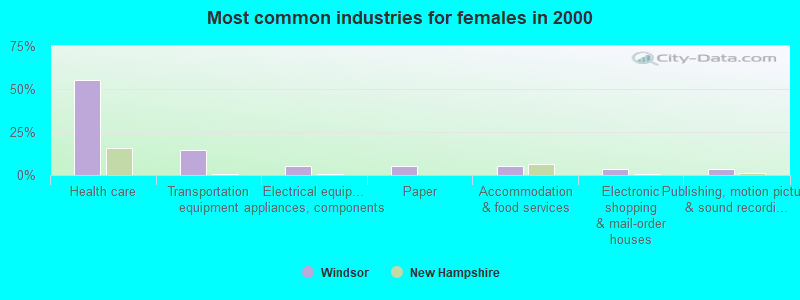
- Health care (55.4%)
- Transportation equipment (14.3%)
- Electrical equipment, appliances, components (5.4%)
- Paper (5.4%)
- Accommodation & food services (5.4%)
- Electronic shopping & mail-order houses (3.6%)
- Publishing, motion picture & sound recording industries (3.6%)
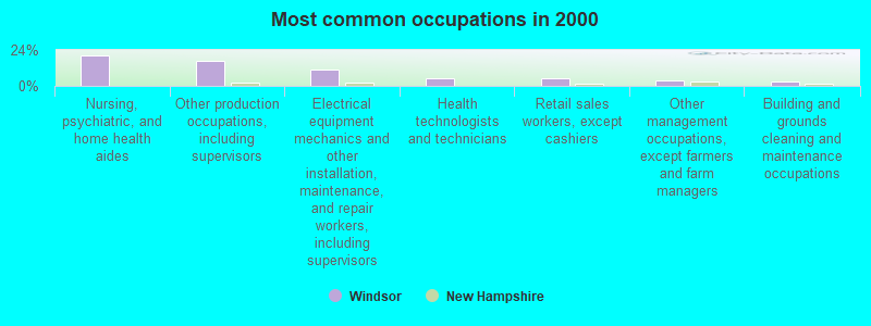
- Nursing, psychiatric, and home health aides (20.6%)
- Other production occupations, including supervisors (16.7%)
- Electrical equipment mechanics and other installation, maintenance, and repair workers, including supervisors (10.8%)
- Health technologists and technicians (4.9%)
- Retail sales workers, except cashiers (4.9%)
- Other management occupations, except farmers and farm managers (3.9%)
- Building and grounds cleaning and maintenance occupations (2.9%)
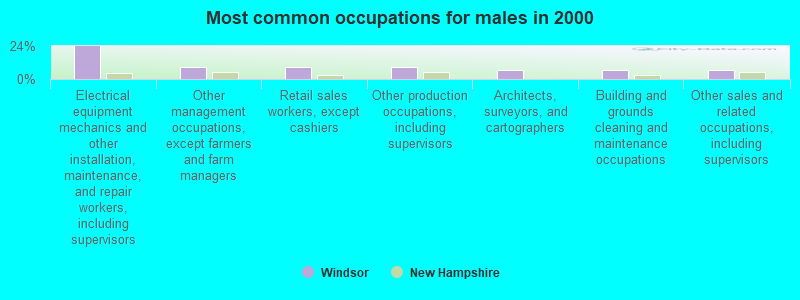
- Electrical equipment mechanics and other installation, maintenance, and repair workers, including supervisors (23.9%)
- Other management occupations, except farmers and farm managers (8.7%)
- Retail sales workers, except cashiers (8.7%)
- Other production occupations, including supervisors (8.7%)
- Architects, surveyors, and cartographers (6.5%)
- Building and grounds cleaning and maintenance occupations (6.5%)
- Other sales and related occupations, including supervisors (6.5%)
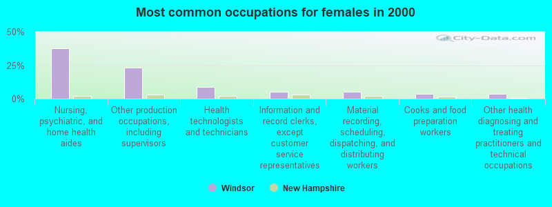
- Nursing, psychiatric, and home health aides (37.5%)
- Other production occupations, including supervisors (23.2%)
- Health technologists and technicians (8.9%)
- Information and record clerks, except customer service representatives (5.4%)
- Material recording, scheduling, dispatching, and distributing workers (5.4%)
- Cooks and food preparation workers (3.6%)
- Other health diagnosing and treating practitioners and technical occupations (3.6%)
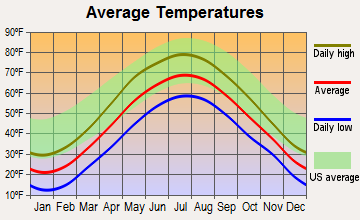
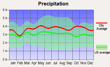
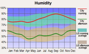
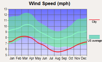
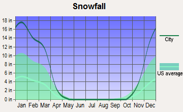
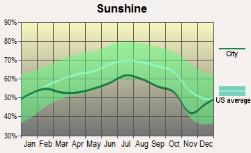
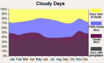
Average climate in Windsor, New Hampshire
Based on data reported by over 4,000 weather stations
(lower is better)
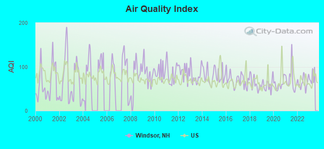
Air Quality Index (AQI) level in 2022 was 64.4. This is about average.
| City: | 64.4 |
| U.S.: | 72.6 |
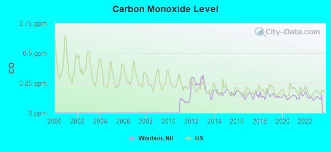
Carbon Monoxide (CO) [ppm] level in 2022 was 0.131. This is significantly better than average. Closest monitor was 14.2 miles away from the city center.
| City: | 0.131 |
| U.S.: | 0.251 |
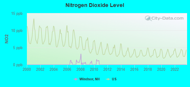
Nitrogen Dioxide (NO2) [ppb] level in 2007 was 1.02. This is significantly better than average. Closest monitor was 18.3 miles away from the city center.
| City: | 1.02 |
| U.S.: | 5.11 |
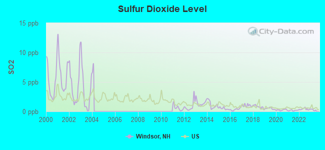
Sulfur Dioxide (SO2) [ppb] level in 2022 was 0.411. This is significantly better than average. Closest monitor was 14.2 miles away from the city center.
| City: | 0.411 |
| U.S.: | 1.515 |
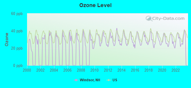
Ozone [ppb] level in 2022 was 30.2. This is about average. Closest monitor was 18.3 miles away from the city center.
| City: | 30.2 |
| U.S.: | 33.3 |
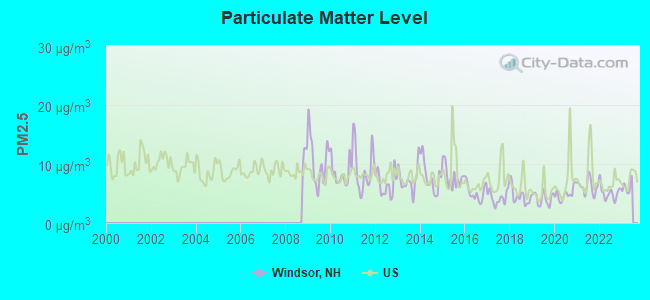
Particulate Matter (PM2.5) [µg/m3] level in 2022 was 5.13. This is significantly better than average. Closest monitor was 14.4 miles away from the city center.
| City: | 5.13 |
| U.S.: | 8.11 |
Tornado activity:
Windsor-area historical tornado activity is slightly above New Hampshire state average. It is 37% smaller than the overall U.S. average.
On 6/9/1953, a category F4 (max. wind speeds 207-260 mph) tornado 45.8 miles away from the Windsor town center killed 90 people and injured 1228 people and caused between $50,000,000 and $500,000,000 in damages.
On 5/31/1998, a category F2 (max. wind speeds 113-157 mph) tornado 7.3 miles away from the town center caused $30,000 in damages.
Earthquake activity:
Windsor-area historical earthquake activity is significantly above New Hampshire state average. It is 70% smaller than the overall U.S. average.On 4/20/2002 at 10:50:47, a magnitude 5.3 (5.3 ML, Depth: 3.0 mi, Class: Moderate, Intensity: VI - VII) earthquake occurred 127.4 miles away from Windsor center
On 10/7/1983 at 10:18:46, a magnitude 5.3 (5.1 MB, 5.3 LG, 5.1 ML) earthquake occurred 129.8 miles away from the city center
On 4/20/2002 at 10:50:47, a magnitude 5.2 (5.2 MB, 4.2 MS, 5.2 MW, 5.0 MW) earthquake occurred 126.8 miles away from the city center
On 1/19/1982 at 00:14:42, a magnitude 4.7 (4.5 MB, 4.7 MD, 4.5 LG, Class: Light, Intensity: IV - V) earthquake occurred 33.6 miles away from the city center
On 10/16/2012 at 23:12:25, a magnitude 4.7 (4.7 ML, Depth: 10.0 mi) earthquake occurred 76.1 miles away from Windsor center
On 10/2/1994 at 11:27:22, a magnitude 3.7 (3.5 LG, 3.7 LG, Depth: 6.2 mi, Class: Light, Intensity: II - III) earthquake occurred 55.2 miles away from the city center
Magnitude types: regional Lg-wave magnitude (LG), body-wave magnitude (MB), duration magnitude (MD), local magnitude (ML), surface-wave magnitude (MS), moment magnitude (MW)
Natural disasters:
The number of natural disasters in Hillsborough County (27) is a lot greater than the US average (15).Major Disasters (Presidential) Declared: 17
Emergencies Declared: 10
Causes of natural disasters: Storms: 13, Floods: 11, Winter Storms: 5, Snowstorms: 4, Hurricanes: 3, Snows: 3, Blizzard: 1, Ice Storm: 1, Snowfall: 1, Wind: 1 (Note: some incidents may be assigned to more than one category).
Airports located in Windsor:
- Windswept Airport (23NH) (Runways: 1)
Colleges/universities with over 2000 students nearest to Windsor:
- Keene State College (about 19 miles; Keene, NH; Full-time enrollment: 5,098)
- Franklin Pierce University (about 24 miles; Rindge, NH; FT enrollment: 2,139)
- NHTI-Concord's Community College (about 26 miles; Concord, NH; FT enrollment: 2,865)
- Saint Anselm College (about 28 miles; Manchester, NH; FT enrollment: 2,059)
- Southern New Hampshire University (about 30 miles; Manchester, NH; FT enrollment: 16,552)
- Mount Washington College (about 30 miles; Manchester, NH; FT enrollment: 2,187)
- Mount Wachusett Community College (about 37 miles; Gardner, MA; FT enrollment: 3,143)
Points of interest:
Notable location: Windsor Mountain Camps (A). Display/hide its location on the map
Lakes and reservoirs: Bagley Pond (A), White Pond (B), Black Pond (C). Display/hide their locations on the map
Streams, rivers, and creeks: Red Brook (A), White Pond Brook (B). Display/hide their locations on the map
Drinking water stations with addresses in Windsor and their reported violations in the past:
WINDSOR HILLS CAMP/LOWER (Population served: 250, Groundwater):Past health violations:WINDSOR MTN INTERNATNL/CABINS (Population served: 80, Groundwater):Past monitoring violations:
- MCL, Monthly (TCR) - Between JUL-2008 and SEP-2008, Contaminant: Coliform. Follow-up actions: St Public Notif requested (AUG-26-2008), St Violation/Reminder Notice (AUG-26-2008), St Public Notif received (SEP-05-2008), St Compliance achieved (SEP-09-2009)
- MCL, Monthly (TCR) - Between JUL-2006 and SEP-2006, Contaminant: Coliform. Follow-up actions: St Public Notif requested (AUG-31-2006), St Violation/Reminder Notice (AUG-31-2006), St Public Notif received (SEP-13-2006), St Formal NOV issued (OCT-11-2006), St Compliance achieved (MAY-31-2007)
- Monitoring, Repeat Major (TCR) - Between JUL-2006 and SEP-2006, Contaminant: Coliform (TCR). Follow-up actions: St Public Notif requested (OCT-25-2006), St Violation/Reminder Notice (OCT-25-2006), St Compliance achieved (MAY-31-2007), St Formal NOV issued (JUL-25-2007), St Public Notif received (JUL-30-2007)
Past health violations:
- MCL, Monthly (TCR) - Between JUL-2010 and SEP-2010, Contaminant: Coliform. Follow-up actions: St Public Notif requested (OCT-21-2010), St Violation/Reminder Notice (OCT-21-2010), St Public Notif received (OCT-25-2010), St Compliance achieved (OCT-19-2011)
Drinking water stations with addresses in Windsor that have no violations reported:
- WINDSOR HILLS CAMP/UPPER (Population served: 250, Primary Water Source Type: Groundwater)
- WINDSOR HILLS CAMP/INN (Population served: 250, Primary Water Source Type: Groundwater)
- WINDSOR MTN INTRNL/DINING HALL (Population served: 250, Primary Water Source Type: Groundwater)
- WINDSOR HILLS CAMP/DINING HALL (Population served: 250, Primary Water Source Type: Groundwater)
| This town: | 2.6 people |
| New Hampshire: | 2.5 people |
| This town: | 77.1% |
| Whole state: | 66.3% |
| This town: | 13.3% |
| Whole state: | 8.3% |
Likely homosexual households (counted as self-reported same-sex unmarried-partner households)
- Lesbian couples: 1.2% of all households
- Gay men: 0.0% of all households
| This town: | 12.3% |
| Whole state: | 6.5% |
46 people in residential treatment centers for emotionally disturbed children in 2000
16 people in other noninstitutional group quarters in 2000
For population 15 years and over in Windsor:
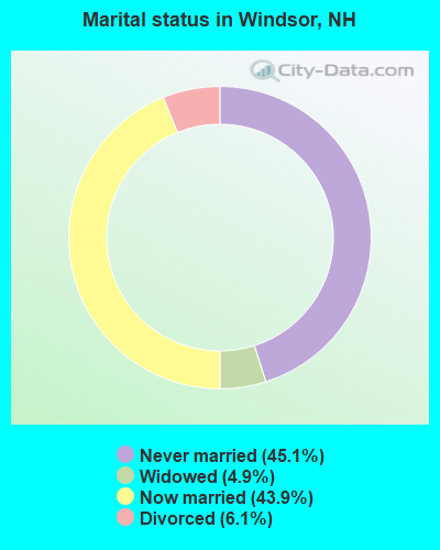
- Never married: 45.1%
- Now married: 43.9%
- Separated: 0.0%
- Widowed: 4.9%
- Divorced: 6.1%
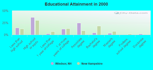
For population 25 years and over in Windsor:
- High school or higher: 85.3%
- Bachelor's degree or higher: 9.5%
- Graduate or professional degree: 5.2%
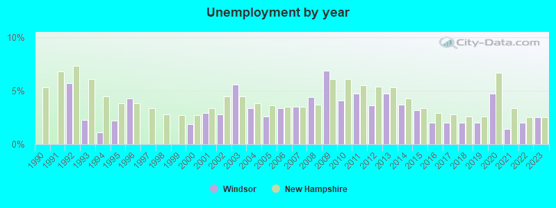
- Unemployed: 1.9%
- Mean travel time to work (commute): 25.1 minutes
| Here: | 9.5 |
| New Hampshire average: | 10.9 |


Graphs represent county-level data. Detailed 2008 Election Results
Religion statistics for Windsor, NH (based on Hillsborough County data)


| Religion | Adherents | Congregations |
|---|---|---|
| Catholic | 124,993 | 40 |
| Evangelical Protestant | 20,588 | 103 |
| Mainline Protestant | 17,794 | 60 |
| Other | 7,365 | 35 |
| Orthodox | 2,990 | 7 |
| Black Protestant | - | 1 |
| None | 226,991 | - |
Food Environment Statistics:
| Hillsborough County: | 1.82 / 10,000 pop. |
| State: | 2.14 / 10,000 pop. |
| This county: | 0.12 / 10,000 pop. |
| State: | 0.15 / 10,000 pop. |
| This county: | 1.65 / 10,000 pop. |
| New Hampshire: | 1.78 / 10,000 pop. |
| This county: | 2.67 / 10,000 pop. |
| New Hampshire: | 4.02 / 10,000 pop. |
| This county: | 8.23 / 10,000 pop. |
| New Hampshire: | 9.70 / 10,000 pop. |
| Hillsborough County: | 6.9% |
| New Hampshire: | 7.6% |
| Hillsborough County: | 24.5% |
| New Hampshire: | 24.4% |
| Hillsborough County: | 15.1% |
| New Hampshire: | 15.9% |
6.73% of this county's 2021 resident taxpayers lived in other counties in 2020 ($92,767 average adjusted gross income)
| Here: | 6.73% |
| New Hampshire average: | 7.66% |
0.01% of residents moved from foreign countries ($183 average AGI)
Hillsborough County: 0.01% New Hampshire average: 0.01%
Top counties from which taxpayers relocated into this county between 2020 and 2021:
| from Middlesex County, MA | |
| from Rockingham County, NH | |
| from Merrimack County, NH |
6.49% of this county's 2020 resident taxpayers moved to other counties in 2021 ($81,100 average adjusted gross income)
| Here: | 6.49% |
| New Hampshire average: | 6.80% |
0.02% of residents moved to foreign countries ($105 average AGI)
Hillsborough County: 0.02% New Hampshire average: 0.01%
Top counties to which taxpayers relocated from this county between 2020 and 2021:
| to Rockingham County, NH | |
| to Merrimack County, NH | |
| to Middlesex County, MA |
Strongest AM radio stations in Windsor:
- WNTK (1020 AM; 10 kW; NEWPORT, NH; Owner: KOOR COMMUNICATIONS, INC.)
- WRKO (680 AM; 50 kW; BOSTON, MA; Owner: ENTERCOM BOSTON LICENSE, LLC)
- WCRN (830 AM; 50 kW; WORCESTER, MA; Owner: CARTER BROADCASTING CORPORATION)
- WNNZ (640 AM; 50 kW; WESTFIELD, MA; Owner: CLEAR CHANNEL BROADCASTING LICENSES, INC.)
- WEEI (850 AM; 50 kW; BOSTON, MA; Owner: ENTERCOM BOSTON LICENSE, LLC)
- WKBK (1290 AM; 5 kW; KEENE, NH; Owner: SAGA COMMUNICATIONS OF NEW ENGLAND, LLC)
- WKOX (1200 AM; 50 kW; FRAMINGHAM, MA; Owner: CAPSTAR TX LIMITED PARTNERSHIP)
- WGIR (610 AM; 5 kW; MANCHESTER, NH; Owner: CAPSTAR TX LIMITED PARTNERSHIP)
- WBIX (1060 AM; 40 kW; NATICK, MA; Owner: LANGER BROADCASTING CORPORATION)
- WVNE (760 AM; daytime; 25 kW; LEICESTER, MA; Owner: BLOUNT MASSCOM, INC.)
- WWZN (1510 AM; 50 kW; BOSTON, MA; Owner: ROSE CITY RADIO CORPORATION)
- WALE (990 AM; 50 kW; GREENVILLE, RI; Owner: NORTH AMERICAN BROADCASTING CO., INC.)
- WBZ (1030 AM; 50 kW; BOSTON, MA; Owner: INFINITY BROADCASTING OPERATIONS, INC.)
Strongest FM radio stations in Windsor:
- WTPL (107.7 FM; HILLSBORO, NH; Owner: CONCORD BROADCASTING, L.L.C.)
- WHDQ (106.1 FM; CLAREMONT, NH; Owner: GREAT NORTHERN RADIO, L.L.C.)
- WNNH (99.1 FM; HENNIKER, NH; Owner: TELE-MEDIA COMPANY OF NEW HAMPSHIRE, L.L.C.)
- WFEX (92.1 FM; PETERBOROUGH, NH; Owner: FNX BROADCASTING OF NEW HAMPSHIRE LLC)
- WVPR (89.5 FM; WINDSOR, VT; Owner: VERMONT PUBLIC RADIO)
- WKNE (103.7 FM; KEENE, NH; Owner: SAGA COMMUNICATIONS OF NEW ENGLAND, LLC)
- WEVN (90.7 FM; KEENE, NH; Owner: NEW HAMPSHIRE PUBLIC RADIO, INC.)
- WVRR (101.7 FM; NEWPORT, NH; Owner: CAPSTAR TX LIMITED PARTNERSHIP)
- WGIR-FM (101.1 FM; MANCHESTER, NH; Owner: CAPSTAR TX LIMITED PARTNERSHIP)
- WQLL (96.5 FM; BEDFORD, NH; Owner: SAGA COMMUNICATIONS OF NEW ENGLAND, LLC)
- WLMW (90.7 FM; MANCHESTER, NH; Owner: KNOWLEDGE FOR LIFE)
- WZID (95.7 FM; MANCHESTER, NH; Owner: SAGA COMMUNICATIONS OF NEW ENGLAND, LLC)
- WJJR (98.1 FM; RUTLAND, VT; Owner: 6 JOHNSON ROAD LICENSES, INC.)
- WZRT (97.1 FM; RUTLAND, VT; Owner: CAPSTAR TX LIMITED PARTNERSHIP)
- WEBK (105.3 FM; KILLINGTON, VT; Owner: 6 JOHNSON ROAD LICENSES, INC.)
- WZSH (107.1 FM; BELLOWS FALLS, VT; Owner: GREAT NORTHERN RADIO, L.L.C.)
- WEQX (102.7 FM; MANCHESTER, VT; Owner: NORTHSHIRE COMMUNICATIONS, INC.)
- WJAN (95.1 FM; SUNDERLAND, VT; Owner: 6 JOHNSON ROAD LICENSES, INC.)
- WNTK-FM (99.7 FM; NEW LONDON, NH; Owner: SHEILA E. VINIKOOR)
- WGLV (91.7 FM; WOODSTOCK, VT; Owner: CHRISTIAN MINISTRIES INC)
TV broadcast stations around Windsor:
- WEKW-TV (Channel 52; KEENE, NH; Owner: UNIVERSITY OF NEW HAMPSHIRE)
FCC Registered Amateur Radio Licenses:
3- Call Sign: N1ZON, Licensee ID: L01300728, Grant Date: 06/29/2017, Expiration Date: 07/03/2027, Certifier: John Drake, Registrant: John Drake, 31 Heartwood Lane, Windsor, NH 03244
- Call Sign: KC1JIX, Licensee ID: L02173823, Grant Date: 03/28/2018, Expiration Date: 03/28/2028, Certifier: Mark L Carroll, Registrant: Mark L Carroll, 175 Black Pond Rd, Windsor, NH 03244
- Call Sign: KC1QWR, Licensee ID: L02539489, Grant Date: 03/22/2022, Expiration Date: 03/22/2032, Certifier: Robert M Nievera, Registrant: Robert M Nievera, 1208 2nd Nh Tnpk, Windsor, NH 03244
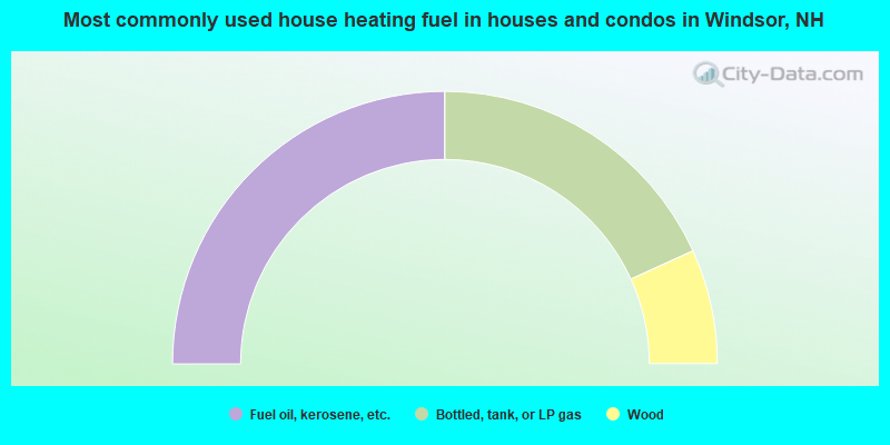
- 50.0%Fuel oil, kerosene, etc.
- 36.4%Bottled, tank, or LP gas
- 13.6%Wood
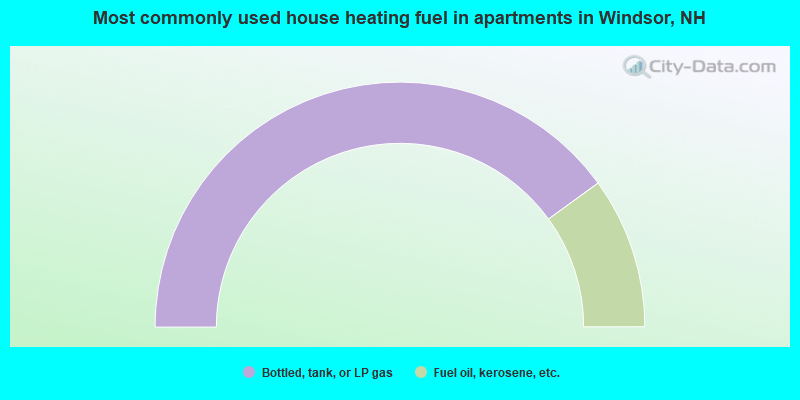
- 80.0%Bottled, tank, or LP gas
- 20.0%Fuel oil, kerosene, etc.
Windsor compared to New Hampshire state average:
- Median house value below state average.
- Unemployed percentage significantly below state average.
- Black race population percentage significantly below state average.
- Hispanic race population percentage below state average.
- Foreign-born population percentage significantly below state average.
- Renting percentage below state average.
- Length of stay since moving in significantly above state average.
- Number of rooms per house significantly below state average.
- House age significantly below state average.
- Institutionalized population percentage significantly above state average.
- Number of college students above state average.
- Percentage of population with a bachelor's degree or higher significantly below state average.