Wheatland, Wisconsin
Submit your own pictures of this town and show them to the world
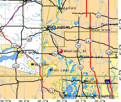
- OSM Map
- General Map
- Google Map
- MSN Map
Population change since 2000: +2.5%
 |
| Males: 1,716 | |
| Females: 1,657 |
| Median resident age: | 42.5 years |
| Wisconsin median age: | 42.6 years |
Zip codes: 53105.
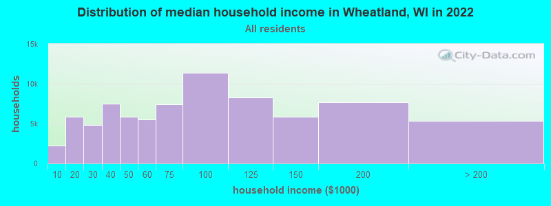
| Wheatland: | $83,128 |
| WI: | $70,996 |
Estimated per capita income in 2022: $39,852 (it was $21,299 in 2000)
Wheatland town income, earnings, and wages data
Estimated median house or condo value in 2022: $275,478 (it was $128,600 in 2000)
| Wheatland: | $275,478 |
| WI: | $252,800 |
Mean prices in 2022: all housing units: $268,741; detached houses: $284,205; townhouses or other attached units: $253,748; in 2-unit structures: $184,859; in 3-to-4-unit structures: $154,710; in 5-or-more-unit structures: $184,932; mobile homes: $45,383
Detailed information about poverty and poor residents in Wheatland, WI


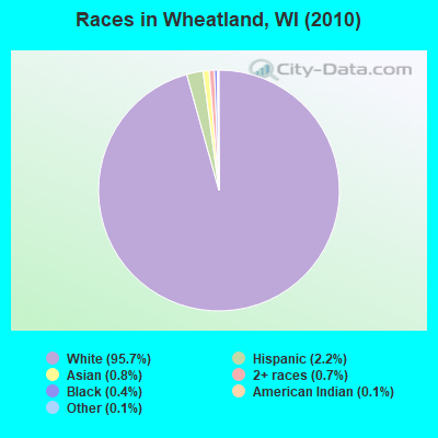
- 3,22795.7%White alone
- 752.2%Hispanic
- 280.8%Asian alone
- 220.7%Two or more races
- 120.4%Black alone
- 50.1%American Indian alone
- 40.1%Other race alone
Races in Wheatland detailed stats: ancestries, foreign born residents, place of birth
 Recent articles from our blog. Our writers, many of them Ph.D. graduates or candidates, create easy-to-read articles on a wide variety of topics.

 | Where to get quality meat? (16 replies) |
| German family will move to the US - where to live? (10 replies) |
| Moving to Kenosha County, but where? (8 replies) |
| Living in Lake Geneva - What is it like? (15 replies) |
| how many transplants regret moving too Wi (106 replies) |
| Tornados and 60 degrees in January (13 replies) |
Latest news from Wheatland, WI collected exclusively by city-data.com from local newspapers, TV, and radio stations
Ancestries: German (47.8%), Irish (16.2%), Polish (10.1%), English (8.9%), United States (7.3%), Italian (6.4%).
Current Local Time: CST time zone
Elevation: 763 feet
Land area: 23.6 square miles.
Population density: 143 people per square mile (very low).
48 residents are foreign born
| This town: | 1.5% |
| Wisconsin: | 3.6% |
| Wheatland town: | 1.8% ($2,324) |
| Wisconsin: | 2.0% ($2,245) |
Nearest city with pop. 50,000+: Kenosha, WI  (19.4 miles , pop. 90,352).
Nearest city with pop. 200,000+: Milwaukee, WI (35.6 miles , pop. 596,974).
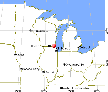
Nearest city with pop. 1,000,000+: Chicago, IL (58.1 miles , pop. 2,896,016).
Nearest cities:
), ), ), ), ), Latitude: 42.58 N, Longitude: 88.23 W
Area code: 262

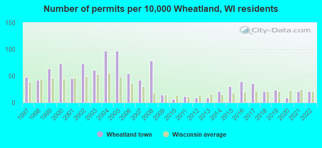
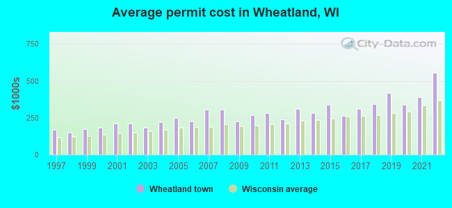
Single-family new house construction building permits:
- 2022: 7 buildings, average cost: $554,200
- 2021: 7 buildings, average cost: $389,100
- 2020: 3 buildings, average cost: $337,600
- 2019: 8 buildings, average cost: $415,600
- 2018: 7 buildings, average cost: $343,100
- 2017: 12 buildings, average cost: $309,100
- 2016: 13 buildings, average cost: $261,500
- 2015: 10 buildings, average cost: $338,600
- 2014: 7 buildings, average cost: $283,600
- 2013: 3 buildings, average cost: $312,100
- 2012: 3 buildings, average cost: $239,300
- 2011: 4 buildings, average cost: $283,500
- 2010: 2 buildings, average cost: $269,000
- 2009: 5 buildings, average cost: $226,800
- 2008: 26 buildings, average cost: $306,100
- 2007: 14 buildings, average cost: $304,800
- 2006: 18 buildings, average cost: $224,100
- 2005: 32 buildings, average cost: $248,600
- 2004: 32 buildings, average cost: $220,200
- 2003: 20 buildings, average cost: $182,600
- 2002: 24 buildings, average cost: $213,000
- 2001: 15 buildings, average cost: $211,400
- 2000: 24 buildings, average cost: $181,200
- 1999: 21 buildings, average cost: $173,700
- 1998: 14 buildings, average cost: $149,400
- 1997: 16 buildings, average cost: $167,500
| Here: | 3.0% |
| Wisconsin: | 2.7% |
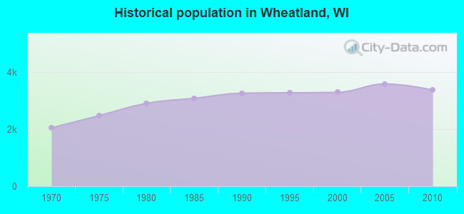
Population change in the 1990s: +25 (+0.8%).
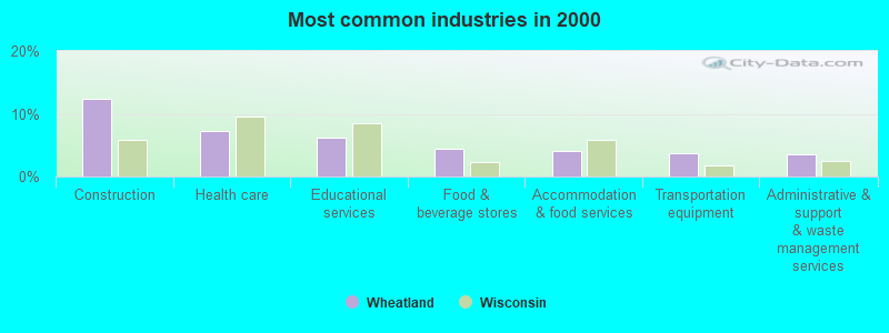
- Construction (12.5%)
- Health care (7.2%)
- Educational services (6.2%)
- Food & beverage stores (4.4%)
- Accommodation & food services (4.1%)
- Transportation equipment (3.8%)
- Administrative & support & waste management services (3.5%)
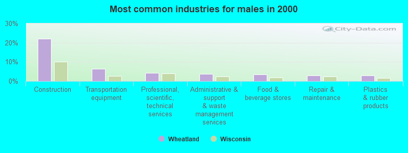
- Construction (22.0%)
- Transportation equipment (6.3%)
- Professional, scientific, technical services (4.2%)
- Administrative & support & waste management services (3.6%)
- Food & beverage stores (3.4%)
- Repair & maintenance (3.0%)
- Plastics & rubber products (3.0%)
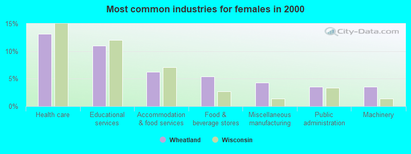
- Health care (13.2%)
- Educational services (11.0%)
- Accommodation & food services (6.2%)
- Food & beverage stores (5.4%)
- Miscellaneous manufacturing (4.3%)
- Public administration (3.5%)
- Machinery (3.5%)
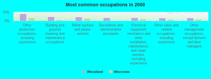
- Other production occupations, including supervisors (8.3%)
- Building and grounds cleaning and maintenance occupations (4.9%)
- Metal workers and plastic workers (4.6%)
- Secretaries and administrative assistants (3.7%)
- Electrical equipment mechanics and other installation, maintenance, and repair workers, including supervisors (3.6%)
- Other sales and related occupations, including supervisors (3.4%)
- Other management occupations, except farmers and farm managers (3.3%)
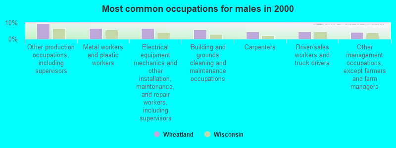
- Other production occupations, including supervisors (9.8%)
- Metal workers and plastic workers (6.8%)
- Electrical equipment mechanics and other installation, maintenance, and repair workers, including supervisors (6.7%)
- Building and grounds cleaning and maintenance occupations (5.7%)
- Carpenters (4.6%)
- Driver/sales workers and truck drivers (4.5%)
- Other management occupations, except farmers and farm managers (4.2%)
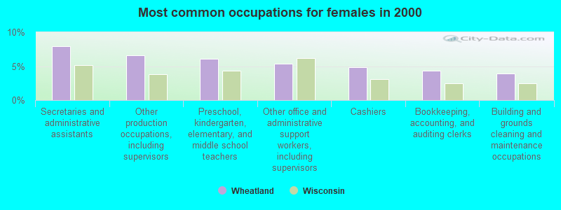
- Secretaries and administrative assistants (8.0%)
- Other production occupations, including supervisors (6.6%)
- Preschool, kindergarten, elementary, and middle school teachers (6.1%)
- Other office and administrative support workers, including supervisors (5.3%)
- Cashiers (4.8%)
- Bookkeeping, accounting, and auditing clerks (4.3%)
- Building and grounds cleaning and maintenance occupations (3.9%)
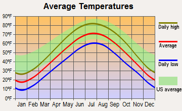
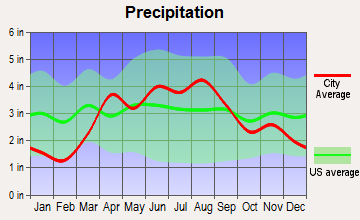
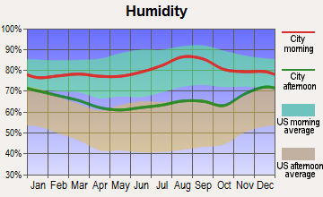
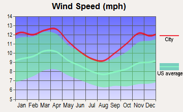
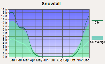
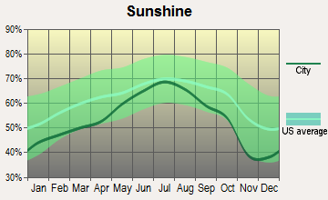
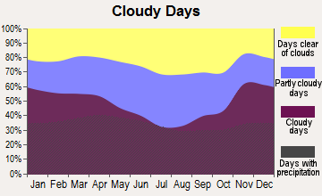
Average climate in Wheatland, Wisconsin
Based on data reported by over 4,000 weather stations
(lower is better)
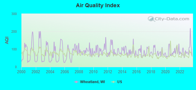
Air Quality Index (AQI) level in 2023 was 106. This is significantly worse than average.
| City: | 106 |
| U.S.: | 73 |
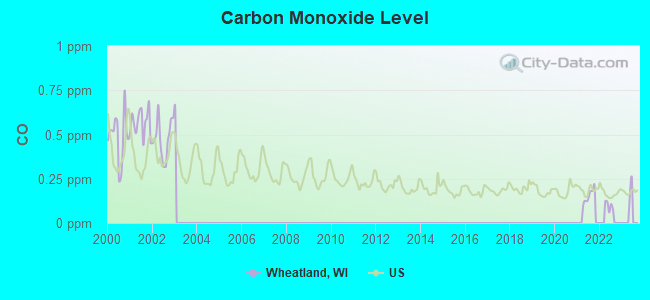
Carbon Monoxide (CO) [ppm] level in 2021 was 0.153. This is significantly better than average. Closest monitor was 21.8 miles away from the city center.
| City: | 0.153 |
| U.S.: | 0.251 |
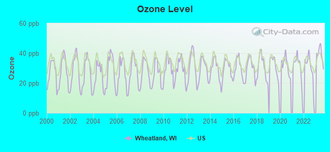
Ozone [ppb] level in 2023 was 39.2. This is about average. Closest monitor was 5.6 miles away from the city center.
| City: | 39.2 |
| U.S.: | 33.3 |
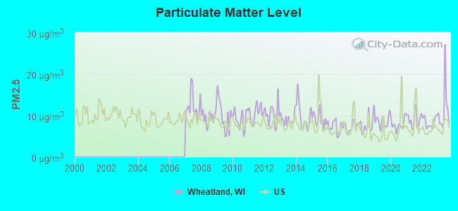
Particulate Matter (PM2.5) [µg/m3] level in 2023 was 11.3. This is worse than average. Closest monitor was 21.8 miles away from the city center.
| City: | 11.3 |
| U.S.: | 8.1 |
Tornado activity:
Wheatland-area historical tornado activity is slightly above Wisconsin state average. It is 34% greater than the overall U.S. average.
On 4/21/1967, a category F4 (max. wind speeds 207-260 mph) tornado 18.8 miles away from the Wheatland town center killed 24 people and injured 450 people and caused between $50,000 and $500,000 in damages.
On 4/11/1965, a category F4 tornado 20.7 miles away from the town center killed 6 people and injured 75 people.
Earthquake activity:
Wheatland-area historical earthquake activity is significantly above Wisconsin state average. It is 28% greater than the overall U.S. average.On 4/18/2008 at 09:36:59, a magnitude 5.4 (5.1 MB, 4.8 MS, 5.4 MW, 5.2 MW, Class: Moderate, Intensity: VI - VII) earthquake occurred 285.9 miles away from Wheatland center
On 6/10/1987 at 23:48:54, a magnitude 5.1 (4.9 MB, 4.4 MS, 4.6 MS, 5.1 LG) earthquake occurred 260.4 miles away from Wheatland center
On 6/28/2004 at 06:10:52, a magnitude 4.2 (4.2 MW, Depth: 6.2 mi, Class: Light, Intensity: IV - V) earthquake occurred 84.6 miles away from the city center
On 4/18/2008 at 09:36:59, a magnitude 5.2 (5.2 MW, Depth: 8.9 mi) earthquake occurred 285.9 miles away from Wheatland center
On 2/10/2010 at 09:59:35, a magnitude 3.8 (3.8 MW, Depth: 6.2 mi, Class: Light, Intensity: II - III) earthquake occurred 44.3 miles away from Wheatland center
On 5/2/2015 at 16:23:07, a magnitude 4.2 (4.2 MW, Depth: 2.8 mi) earthquake occurred 144.8 miles away from Wheatland center
Magnitude types: regional Lg-wave magnitude (LG), body-wave magnitude (MB), surface-wave magnitude (MS), moment magnitude (MW)
Natural disasters:
The number of natural disasters in Kenosha County (14) is near the US average (15).Major Disasters (Presidential) Declared: 10
Emergencies Declared: 4
Causes of natural disasters: Floods: 8, Storms: 7, Tornadoes: 3, Winter Storms: 3, Snowstorms: 2, Blizzard: 1, Hurricane: 1, Snow: 1, Other: 1 (Note: some incidents may be assigned to more than one category).
Hospitals and medical centers near Wheatland:
- HILLCREST NURSING HOME (Nursing Home, about 4 miles away; TWIN LAKES, WI)
- AURORA MEMORIAL HSPTL BURLINGTON Acute Care Hospitals (about 8 miles away; BURLINGTON, WI)
- KINDRED NURSING AND REHAB-BURLINGTON (Nursing Home, about 8 miles away; BURLINGTON, WI)
- MOUNT CARMEL CARE CENTER (Nursing Home, about 8 miles away; BURLINGTON, WI)
- FMC - ANTIOCH (Dialysis Facility, about 10 miles away; ANTIOCH, IL)
- GENEVA LAKE MANOR (Nursing Home, about 11 miles away; LAKE GENEVA, WI)
- HOME CARE NETWORK (Home Health Center, about 11 miles away; LAKE GENEVA, WI)
Colleges/universities with over 2000 students nearest to Wheatland:
- College of Lake County (about 19 miles; Grayslake, IL; Full-time enrollment: 11,041)
- Gateway Technical College (about 20 miles; Kenosha, WI; FT enrollment: 5,089)
- University of Wisconsin-Parkside (about 20 miles; Kenosha, WI; FT enrollment: 3,843)
- Carthage College (about 21 miles; Kenosha, WI; FT enrollment: 3,130)
- McHenry County College (about 24 miles; Crystal Lake, IL; FT enrollment: 4,886)
- Carroll University (about 30 miles; Waukesha, WI; FT enrollment: 3,313)
- University of Wisconsin-Whitewater (about 32 miles; Whitewater, WI; FT enrollment: 11,124)
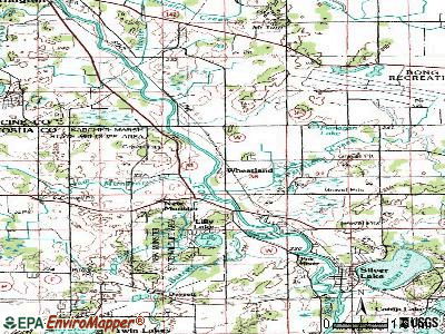
Points of interest:
Notable locations in Wheatland: Camp Oh-da-ko-ta (A), Wheatland Volunteer Fire Department (B). Display/hide their locations on the map
Churches in Wheatland include: Saint Theresa Church (A), Saint Johns Lutheran Church (B). Display/hide their locations on the map
Cemeteries: High Street Cemetery (1), Saint Johns Cemetery (2), First German Presbyterian Cemetery (3), Free Will Baptist Cemetery (4), Saint Alphonsus Cemetery (5), Wheatland Cemetery (6). Display/hide their locations on the map
Lakes and reservoirs: Lilly Lake (A), Dyer Lake (B). Display/hide their locations on the map
Creeks: Bassett Creek (A), Palmer Creek (B), New Munster Creek (C), Peterson Creek (D). Display/hide their locations on the map
Park in Wheatland: New Munster Bog Island State Natural Area (1). Display/hide its location on the map
| This town: | 2.6 people |
| Wisconsin: | 2.4 people |
| This town: | 72.9% |
| Whole state: | 64.4% |
| This town: | 7.5% |
| Whole state: | 7.3% |
Likely homosexual households (counted as self-reported same-sex unmarried-partner households)
- Lesbian couples: 0.5% of all households
- Gay men: 0.2% of all households
| This town: | 5.3% |
| Whole state: | 8.7% |
| This town: | 2.6% |
| Whole state: | 3.7% |
For population 15 years and over in Wheatland:
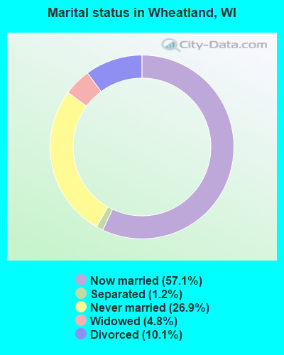
- Never married: 26.9%
- Now married: 57.1%
- Separated: 1.2%
- Widowed: 4.8%
- Divorced: 10.1%
For population 25 years and over in Wheatland:
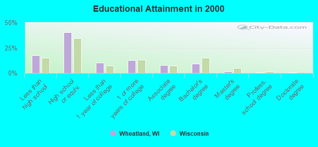
- High school or higher: 82.3%
- Bachelor's degree or higher: 11.6%
- Graduate or professional degree: 2.5%
- Unemployed: 5.0%
- Mean travel time to work (commute): 29.8 minutes
| Here: | 9.0 |
| Wisconsin average: | 11.0 |

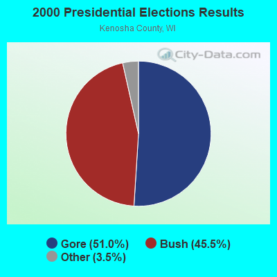
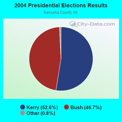
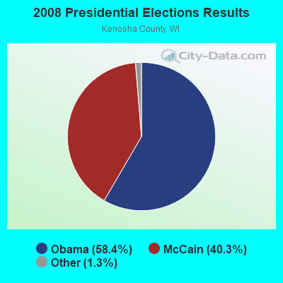
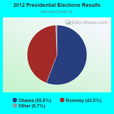
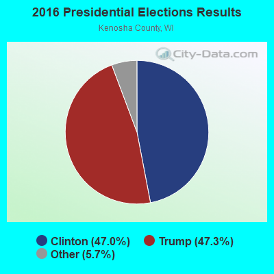
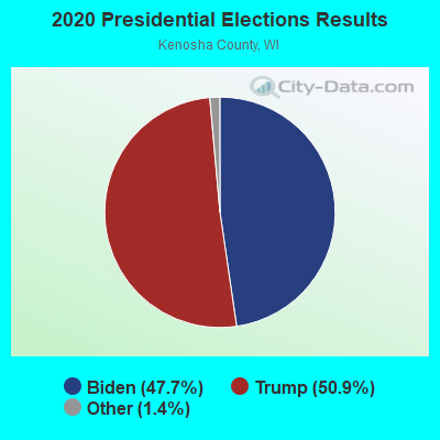
Graphs represent county-level data. Detailed 2008 Election Results
Religion statistics for Wheatland, WI (based on Kenosha County data)
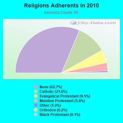
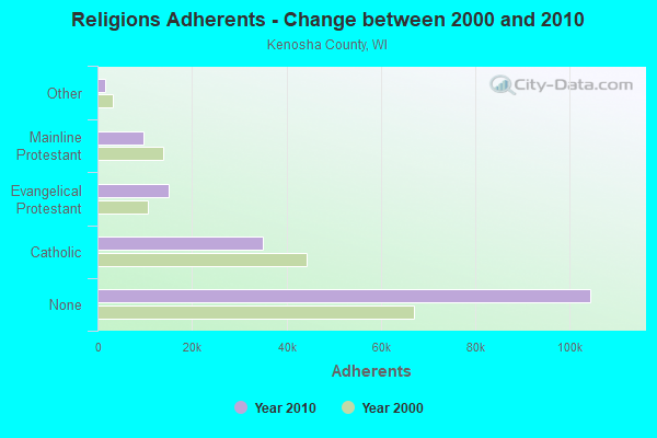
| Religion | Adherents | Congregations |
|---|---|---|
| Catholic | 35,008 | 14 |
| Evangelical Protestant | 15,183 | 55 |
| Mainline Protestant | 9,675 | 29 |
| Other | 1,635 | 11 |
| Orthodox | 300 | 2 |
| Black Protestant | 199 | 3 |
| None | 104,426 | - |
Food Environment Statistics:
| This county: | 1.96 / 10,000 pop. |
| Wisconsin: | 1.86 / 10,000 pop. |
| Kenosha County: | 0.25 / 10,000 pop. |
| Wisconsin: | 0.38 / 10,000 pop. |
| Here: | 3.56 / 10,000 pop. |
| State: | 4.12 / 10,000 pop. |
| Kenosha County: | 7.06 / 10,000 pop. |
| Wisconsin: | 8.64 / 10,000 pop. |
| Here: | 7.6% |
| Wisconsin: | 7.6% |
| Here: | 28.2% |
| Wisconsin: | 27.5% |
| Kenosha County: | 13.9% |
| Wisconsin: | 13.0% |
Strongest AM radio stations in Wheatland:
- WTMJ (620 AM; 50 kW; MILWAUKEE, WI; Owner: JOURNAL BROADCAST CORPORATION)
- WISN (1130 AM; 50 kW; MILWAUKEE, WI; Owner: CAPSTAR TX LIMITED PARTNERSHIP)
- WGN (720 AM; 50 kW; CHICAGO, IL; Owner: WGN CONTINENTAL BROADCASTING CO.)
- WBBM (780 AM; 50 kW; CHICAGO, IL; Owner: INFINITY BROADCASTING OPERATIONS, INC.)
- WSCR (670 AM; 50 kW; CHICAGO, IL; Owner: INFINITY BROADCASTING OPERATIONS, INC.)
- WMVP (1000 AM; 50 kW; CHICAGO, IL; Owner: ABC, INC.)
- WLS (890 AM; 50 kW; CHICAGO, IL; Owner: WLS, INC.)
- WZRK (1550 AM; 1 kW; LAKE GENEVA, WI)
- WYLL (1160 AM; 50 kW; CHICAGO, IL; Owner: SCA LICENSE CORPORATION)
- WNVR (1030 AM; 5 kW; VERNON HILLS, IL; Owner: POLNET COMMUNICATIONS, LTD.)
- WAUK (1510 AM; daytime; 10 kW; WAUKESHA, WI; Owner: WALT-WEST WISCONSIN, INC.)
- WOKY (920 AM; 5 kW; MILWAUKEE, WI; Owner: CLEAR CHANNEL BROADCASTING LICENSES, INC.)
- WEMP (1250 AM; 5 kW; MILWAUKEE, WI; Owner: ENTERCOM MILWAUKEE LICENSE, LLC)
Strongest FM radio stations in Wheatland:
- WLKG (96.1 FM; LAKE GENEVA, WI; Owner: CTJ COMMUNICATIONS, LTD.)
- WWDV (96.9 FM; ZION, IL; Owner: BONNEVILLE HOLDING COMPANY)
- WKKV-FM (100.7 FM; RACINE, WI; Owner: CLEAR CHANNEL BROADCASTING LICENSES, INC.)
- WEZY (92.1 FM; RACINE, WI; Owner: RACINE BROADCASTING, L.L.C.)
- WIIL (95.1 FM; KENOSHA, WI; Owner: NM LICENSING, LLC)
- WZSR (105.5 FM; WOODSTOCK, IL; Owner: NM LICENSING, LLC)
- WFZH (105.3 FM; MUKWONAGO, WI; Owner: CARON BROADCASTING, INC.)
- WJZI (93.3 FM; MILWAUKEE, WI; Owner: MILWAUKEE RADIO ALLIANCE, LLC)
- WMIL-FM (106.1 FM; WAUKESHA, WI; Owner: CLEAR CHANNEL BROADCASTING LICENSES, INC.)
- WKTI-FM (94.5 FM; MILWAUKEE, WI; Owner: JOURNAL BROADCAST CORPORATION)
- WBSD (89.1 FM; BURLINGTON, WI; Owner: BURLINGTON AREA SCHOOL DISTRICT)
- WHAD (90.7 FM; DELAFIELD, WI; Owner: STATE OF WISCONSIN - EDUCATIONAL COMMUNICATIONS BOARD)
- WLTQ (97.3 FM; MILWAUKEE, WI; Owner: CAPSTAR TX LIMITED PARTNERSHIP)
- WUWM (89.7 FM; MILWAUKEE, WI; Owner: BOARD OF REGENTS, UNIVERSITY OF WISCONSIN SYSTEM)
- WVCY-FM (107.7 FM; MILWAUKEE, WI; Owner: VCY AMERICA, INC.)
- WXSS (103.7 FM; WAUWATOSA, WI; Owner: ENTERCOM MILWAUKEE LICENSE, LLC)
- WKLH (96.5 FM; MILWAUKEE, WI; Owner: LAKEFRONT COMMUNICATIONS, LLC)
- WMWK (88.1 FM; MILWAUKEE, WI; Owner: FAMILY STATIONS, INC.)
- WEXT (104.7 FM; STURTEVANT, WI; Owner: NM LICENSING, LLC)
- WMYX-FM (99.1 FM; MILWAUKEE, WI; Owner: ENTERCOM MILWAUKEE LICENSE, LLC)
TV broadcast stations around Wheatland:
- W64CQ (Channel 64; ARLINGTON HEIGHTS, IL; Owner: TRINITY BROADCASTING NETWORK)
- W34CK (Channel 34; ARLINGTON HEIGHTS, IL; Owner: FIRST UNITED, INC.)
- WJJA (Channel 49; RACINE, WI; Owner: TV-49, INC.)
- WLS-TV (Channel 7; CHICAGO, IL; Owner: WLS TELEVISION, INC.)
- WMAQ-TV (Channel 5; CHICAGO, IL; Owner: NBC SUBSIDIARY (WMAQ-TV), INC.)
- WTTW (Channel 11; CHICAGO, IL; Owner: WINDOW TO THE WORLD COMMUNICATIONS, INC.)
- WGBO-TV (Channel 66; JOLIET, IL; Owner: WGBO LICENSE PARTNERSHIP, G.P.)
- WPXE (Channel 55; KENOSHA, WI; Owner: PAXSON MILWAUKEE LICENSE, INC.)
- WMVS (Channel 10; MILWAUKEE, WI; Owner: MILWAUKEE AREA TECHNICAL COLLEGE DISTRICT BOARD)
- WMVT (Channel 36; MILWAUKEE, WI; Owner: MILWAUKEE AREA TECHNICAL COLLEGE DISTRICT BOARD)
- WDJT-TV (Channel 58; MILWAUKEE, WI; Owner: WDJT-TV LIMITED PARTNERSHIP)
- WISN-TV (Channel 12; MILWAUKEE, WI; Owner: WISN HEARST-ARGYLE TV, INC. (CA CORP.))
- WCGV-TV (Channel 24; MILWAUKEE, WI; Owner: WCGV LICENSEE, LLC)
- WMLW-CA (Channel 46; MILWAUKEE, WI; Owner: CHANNEL 41 AND 63 LIMITED PARTNERSHIP)
- WVTV (Channel 18; MILWAUKEE, WI; Owner: WVTV LICENSEE, INC.)
- WTMJ-TV (Channel 4; MILWAUKEE, WI; Owner: JOURNAL BROADCAST CORPORATION)
- W63CU (Channel 63; MILWAUKEE, WI; Owner: CHANNEL 41 AND 63 LIMITED PARTNERSHIP)
- WPWR-TV (Channel 50; GARY, IN; Owner: FOX TELEVISION STATIONS, INC.)
- WXFT (Channel 60; AURORA, IL; Owner: TELEFUTURA CHICAGO LLC)
- WCIU-TV (Channel 26; CHICAGO, IL; Owner: WCIU-TV LIMITED PARTNERSHIP)
- WCPX (Channel 38; CHICAGO, IL; Owner: PAXSON CHICAGO LICENSE, INC.)
- WVCY-TV (Channel 30; MILWAUKEE, WI; Owner: VCY AMERICA, INC.)
- WITI (Channel 6; MILWAUKEE, WI; Owner: WITI LICENSE,INC.)
- WTAS-LP (Channel 43; WAUKESHA, WI; Owner: WAUKESHA TOWER ASSOCIATES)
- National Bridge Inventory (NBI) Statistics
- 7Number of bridges
- 98ft / 30.1mTotal length
- $1,271,000Total costs
- 40,548Total average daily traffic
- 2,436Total average daily truck traffic
- 70,115Total future (year 2039) average daily traffic
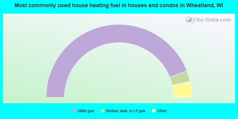
- 88.1%Utility gas
- 4.9%Bottled, tank, or LP gas
- 3.6%Electricity
- 3.0%Fuel oil, kerosene, etc.
- 0.4%Wood
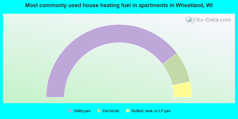
- 79.3%Utility gas
- 13.8%Electricity
- 6.9%Bottled, tank, or LP gas
Wheatland compared to Wisconsin state average:
- Unemployed percentage below state average.
- Black race population percentage significantly below state average.
- Hispanic race population percentage significantly below state average.
- Foreign-born population percentage significantly below state average.
- Renting percentage below state average.
- Length of stay since moving in significantly above state average.
- Number of rooms per house significantly below state average.
- House age significantly below state average.
- Percentage of population with a bachelor's degree or higher below state average.