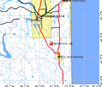
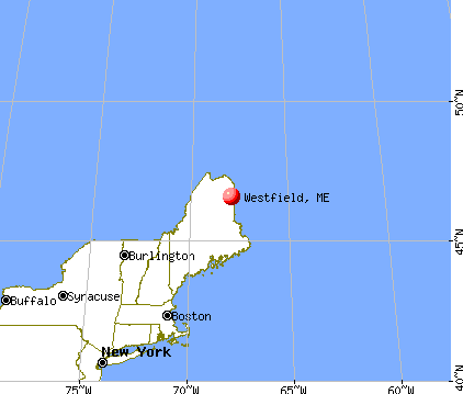
Westfield, Maine
Submit your own pictures of this town and show them to the world
- OSM Map
- General Map
- Google Map
- MSN Map
Population change since 2000: -1.8%
 |
| Males: 279 | |
| Females: 270 |
| Median resident age: | 48.3 years |
| Maine median age: | 43.0 years |
Zip codes: 04787.
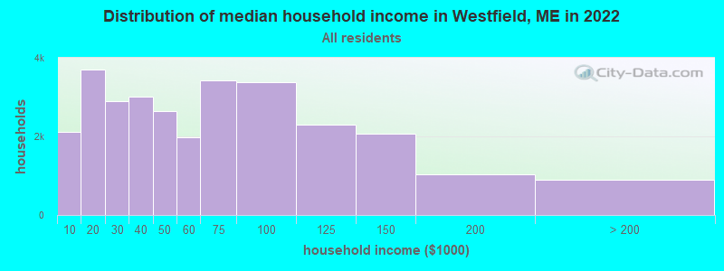
| Westfield: | $48,269 |
| ME: | $69,543 |
Estimated per capita income in 2022: $27,929 (it was $13,533 in 2000)
Westfield town income, earnings, and wages data
Estimated median house or condo value in 2022: $122,757 (it was $50,700 in 2000)
| Westfield: | $122,757 |
| ME: | $290,600 |
Mean prices in 2022: all housing units: $179,108; detached houses: $185,023; townhouses or other attached units: $218,327; in 2-unit structures: $262,505; in 3-to-4-unit structures: $121,406; in 5-or-more-unit structures: $185,084; mobile homes: $117,009; occupied boats, rvs, vans, etc.: $12,682
Detailed information about poverty and poor residents in Westfield, ME


- 54398.9%White alone
- 40.7%American Indian alone
- 20.4%Black alone
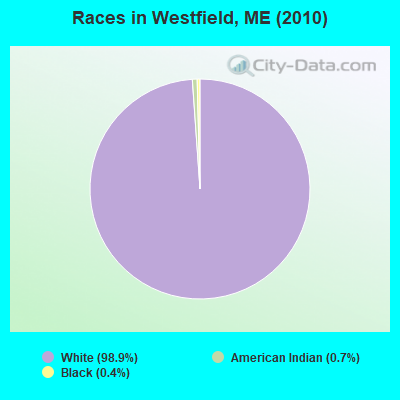
Races in Westfield detailed stats: ancestries, foreign born residents, place of birth
 Recent articles from our blog. Our writers, many of them Ph.D. graduates or candidates, create easy-to-read articles on a wide variety of topics.

 | Retiring from western Ma to Wells area (13 replies) |
| Hidden Mainers and Hampshirites (19 replies) |
| Presque Ilse and surrounding, house to rent (0 replies) |
| Aroostook County questions (46 replies) |
| my search for housing (16 replies) |
| Considering moving to Northern Maine, Aroostook County. (24 replies) |
Latest news from Westfield, ME collected exclusively by city-data.com from local newspapers, TV, and radio stations
Ancestries: English (31.8%), French (21.3%), Irish (16.3%), Scottish (8.1%), Scotch-Irish (7.0%), German (6.8%).
Current Local Time: EST time zone
Incorporated on 03/07/1905
Elevation: 475 feet
Land area: 40.3 square miles.
Population density: 14 people per square mile (very low).
29 residents are foreign born (4.7% North America, 0.5% Europe).
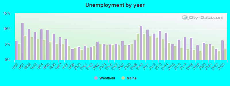
| This town: | 5.2% |
| Maine: | 2.9% |
| Westfield town: | 1.3% ($657) |
| Maine: | 1.5% ($1,417) |
Nearest city with pop. 50,000+: Portland, ME  (230.7 miles , pop. 64,249).
Nearest city with pop. 200,000+: Boston, MA (332.3 miles , pop. 589,141).
Nearest city with pop. 1,000,000+: Bronx, NY (494.3 miles , pop. 1,332,650).
Nearest cities:
), ), ), ), ), Latitude: 46.57 N, Longitude: 67.93 W
Area code commonly used in this area: 207

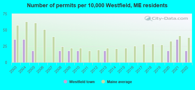
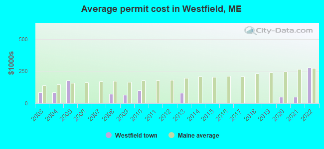
Single-family new house construction building permits:
- 2022: 1 building, cost: $279,200
- 2021: 2 buildings, average cost: $50,000
- 2020: 1 building, cost: $50,000
- 2013: 1 building, cost: $80,000
- 2010: 1 building, cost: $100,000
- 2009: 1 building, cost: $65,000
- 2008: 1 building, cost: $75,000
- 2005: 1 building, cost: $180,000
- 2004: 2 buildings, average cost: $85,000
- 2003: 2 buildings, average cost: $85,000
| Here: | 6.3% |
| Maine: | 3.4% |
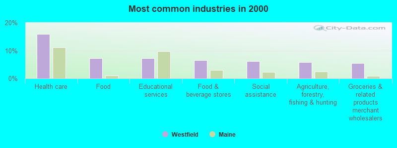
- Health care (15.9%)
- Food (7.2%)
- Educational services (7.2%)
- Food & beverage stores (6.5%)
- Social assistance (6.1%)
- Agriculture, forestry, fishing & hunting (5.8%)
- Groceries & related products merchant wholesalers (5.4%)
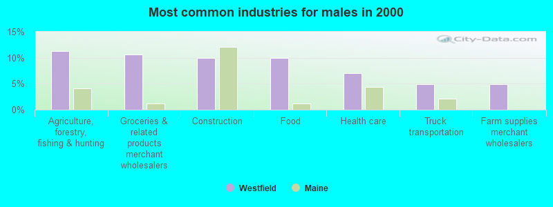
- Agriculture, forestry, fishing & hunting (11.3%)
- Groceries & related products merchant wholesalers (10.6%)
- Construction (9.9%)
- Food (9.9%)
- Health care (7.1%)
- Truck transportation (5.0%)
- Farm supplies merchant wholesalers (5.0%)
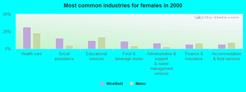
- Health care (25.0%)
- Social assistance (12.5%)
- Educational services (9.6%)
- Food & beverage stores (8.8%)
- Administrative & support & waste management services (6.6%)
- Finance & insurance (5.1%)
- Accommodation & food services (5.1%)

- Driver/sales workers and truck drivers (8.3%)
- Other sales and related occupations, including supervisors (5.4%)
- Health technologists and technicians (5.1%)
- Material recording, scheduling, dispatching, and distributing workers (4.7%)
- Secretaries and administrative assistants (4.0%)
- Sales representatives, services, wholesale and manufacturing (3.6%)
- Counselors, social workers, and other community and social service specialists (3.6%)
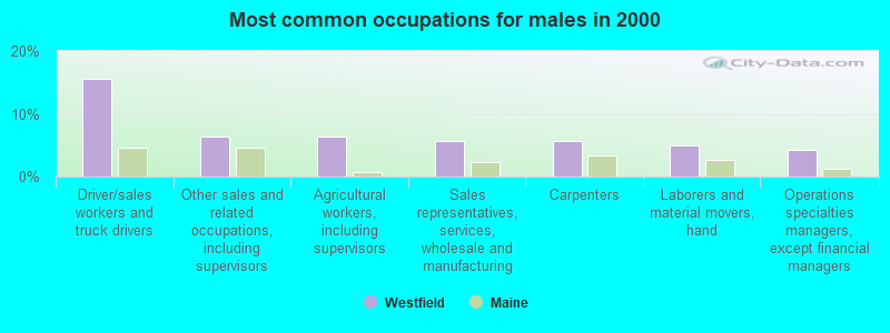
- Driver/sales workers and truck drivers (15.6%)
- Other sales and related occupations, including supervisors (6.4%)
- Agricultural workers, including supervisors (6.4%)
- Sales representatives, services, wholesale and manufacturing (5.7%)
- Carpenters (5.7%)
- Laborers and material movers, hand (5.0%)
- Operations specialties managers, except financial managers (4.3%)
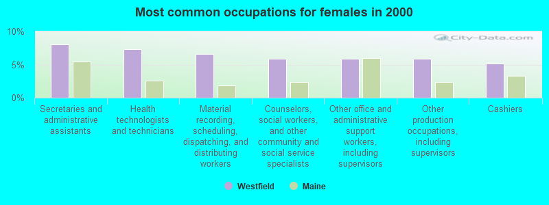
- Secretaries and administrative assistants (8.1%)
- Health technologists and technicians (7.4%)
- Material recording, scheduling, dispatching, and distributing workers (6.6%)
- Counselors, social workers, and other community and social service specialists (5.9%)
- Other office and administrative support workers, including supervisors (5.9%)
- Other production occupations, including supervisors (5.9%)
- Cashiers (5.1%)
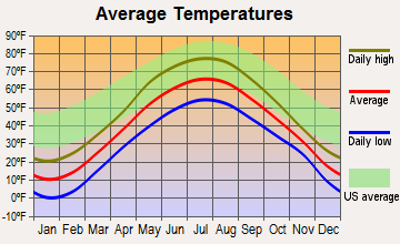
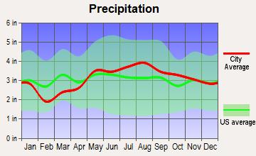
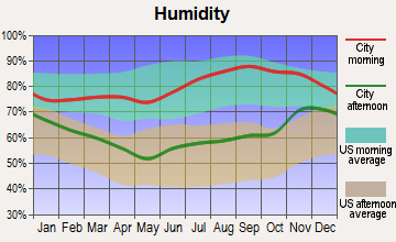
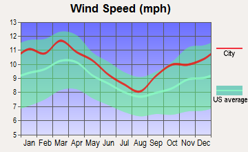
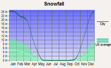
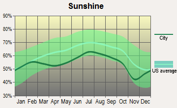
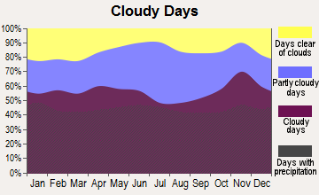
Average climate in Westfield, Maine
Based on data reported by over 4,000 weather stations
(lower is better)
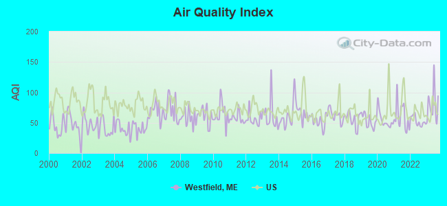
Air Quality Index (AQI) level in 2023 was 79.3. This is about average.
| City: | 79.3 |
| U.S.: | 72.6 |
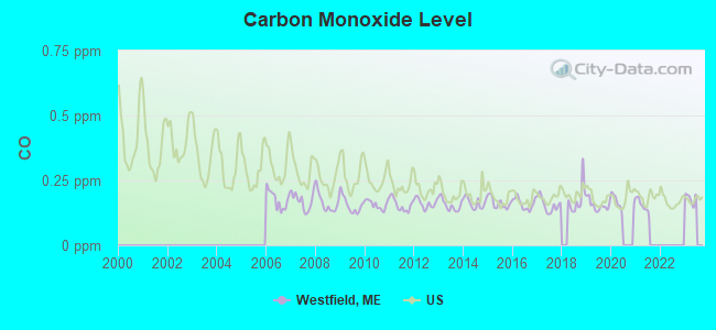
Carbon Monoxide (CO) [ppm] level in 2021 was 0.155. This is significantly better than average. Closest monitor was 10.2 miles away from the city center.
| City: | 0.155 |
| U.S.: | 0.251 |
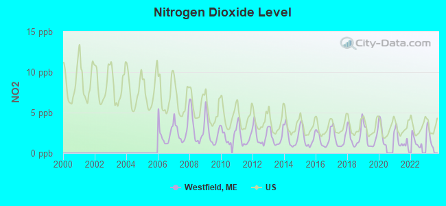
Nitrogen Dioxide (NO2) [ppb] level in 2022 was 1.41. This is significantly better than average. Closest monitor was 8.8 miles away from the city center.
| City: | 1.41 |
| U.S.: | 5.11 |
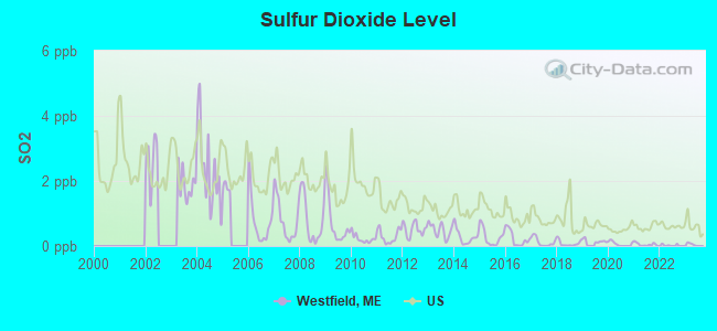
Sulfur Dioxide (SO2) [ppb] level in 2022 was 0.0234. This is significantly better than average. Closest monitor was 6.8 miles away from the city center.
| City: | 0.0234 |
| U.S.: | 1.5147 |
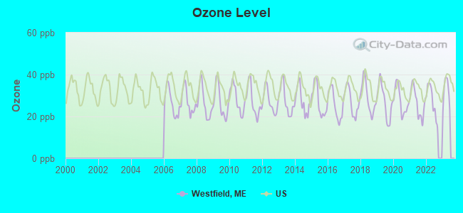
Ozone [ppb] level in 2022 was 27.3. This is better than average. Closest monitor was 8.8 miles away from the city center.
| City: | 27.3 |
| U.S.: | 33.3 |
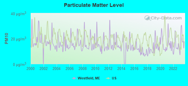
Particulate Matter (PM10) [µg/m3] level in 2023 was 19.0. This is about average. Closest monitor was 4.9 miles away from the city center.
| City: | 19.0 |
| U.S.: | 19.2 |
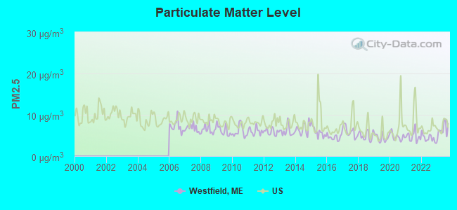
Particulate Matter (PM2.5) [µg/m3] level in 2023 was 6.47. This is better than average. Closest monitor was 9.0 miles away from the city center.
| City: | 6.47 |
| U.S.: | 8.11 |
Earthquake activity:
Westfield-area historical earthquake activity is above Maine state average. It is 87% smaller than the overall U.S. average.On 4/20/2002 at 10:50:47, a magnitude 5.3 (5.3 ML, Depth: 3.0 mi, Class: Moderate, Intensity: VI - VII) earthquake occurred 313.2 miles away from Westfield center
On 7/14/2006 at 09:34:48, a magnitude 3.9 (3.9 MD, Depth: 8.6 mi, Class: Light, Intensity: II - III) earthquake occurred 41.6 miles away from the city center
On 4/20/2002 at 10:50:47, a magnitude 5.2 (5.2 MB, 4.2 MS, 5.2 MW, 5.0 MW) earthquake occurred 314.9 miles away from the city center
On 10/16/2012 at 23:12:25, a magnitude 4.7 (4.7 ML, Depth: 10.0 mi, Class: Light, Intensity: IV - V) earthquake occurred 244.6 miles away from Westfield center
On 10/7/1983 at 10:18:46, a magnitude 5.3 (5.1 MB, 5.3 LG, 5.1 ML) earthquake occurred 360.4 miles away from the city center
On 1/19/1982 at 00:14:42, a magnitude 4.7 (4.5 MB, 4.7 MD, 4.5 LG) earthquake occurred 277.6 miles away from Westfield center
Magnitude types: regional Lg-wave magnitude (LG), body-wave magnitude (MB), duration magnitude (MD), local magnitude (ML), surface-wave magnitude (MS), moment magnitude (MW)
Natural disasters:
The number of natural disasters in Aroostook County (22) is greater than the US average (15).Major Disasters (Presidential) Declared: 13
Emergencies Declared: 9
Causes of natural disasters: Floods: 10, Storms: 8, Snows: 7, Heavy Rains: 2, Blizzard: 1, Hurricane: 1, Ice Storm: 1, Snowfall: 1, Snowstorm: 1, Wind: 1, Winter Storm: 1, Other: 2 (Note: some incidents may be assigned to more than one category).
Hospitals and medical centers near Westfield:
Colleges/universities with over 2000 students nearest to Westfield:
- University of Maine (about 121 miles; Orono, ME; Full-time enrollment: 8,931)
- Husson University (about 128 miles; Bangor, ME; FT enrollment: 2,421)
- University of Maine at Farmington (about 170 miles; Farmington, ME; FT enrollment: 2,036)
- University of Maine at Augusta (about 179 miles; Augusta, ME; FT enrollment: 3,204)
- Saint Joseph's College of Maine (about 227 miles; Standish, ME; FT enrollment: 2,010)
- Southern Maine Community College (about 231 miles; South Portland, ME; FT enrollment: 4,666)
- University of Southern Maine (about 232 miles; Portland, ME; FT enrollment: 6,647)
Public elementary/middle school in Westfield:
- ENFIELD STATION ELEMENTARY SCHOOL (Students: 288, Location: 561 HAMMETT ROAD, Grades: PK-5)
Points of interest:
Cemetery: Marshall Cemetery (1). Display/hide its location on the map
Lakes and reservoirs: Westfield Lake (A), Water District Reservoir (B), Youngs Lake (C), Burntland Stream (D), Smith Farm Pond (E). Display/hide their locations on the map
Streams, rivers, and creeks: Little Burnt Land Stream (A), Rideout Brook (B), Johnson Brook (C), Pretty Brook (D). Display/hide their locations on the map
Hotel: First Settler's Lodge (Houlton Road) (1). Display/hide its approximate location on the map
Drinking water stations with addresses in Westfield and their reported violations in the past:
CAMPERS PARADISE (Population served: 80, Groundwater):Past monitoring violations:
- One routine major monitoring violation
| This town: | 2.4 people |
| Maine: | 2.3 people |
| This town: | 73.6% |
| Whole state: | 62.9% |
| This town: | 7.9% |
| Whole state: | 9.4% |
Likely homosexual households (counted as self-reported same-sex unmarried-partner households)
- Lesbian couples: 0.5% of all households
- Gay men: 0.9% of all households
| This town: | 15.0% |
| Whole state: | 10.9% |
| This town: | 4.2% |
| Whole state: | 4.1% |
30 people in nursing homes in 2000
For population 15 years and over in Westfield:
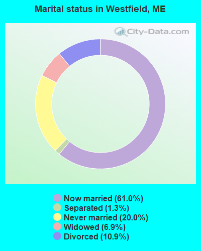
- Never married: 20.0%
- Now married: 61.0%
- Separated: 1.3%
- Widowed: 6.9%
- Divorced: 10.9%
For population 25 years and over in Westfield:
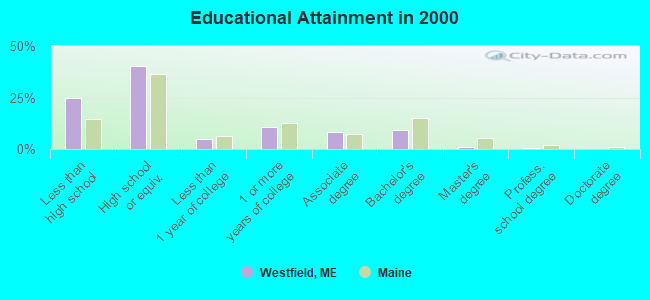
- High school or higher: 75.0%
- Bachelor's degree or higher: 10.7%
- Graduate or professional degree: 1.4%
- Unemployed: 4.8%
- Mean travel time to work (commute): 22.0 minutes
| Here: | 11.1 |
| Maine average: | 11.2 |


Graphs represent county-level data. Detailed 2008 Election Results
Religion statistics for Westfield, ME (based on Aroostook County data)


| Religion | Adherents | Congregations |
|---|---|---|
| Catholic | 22,200 | 27 |
| Mainline Protestant | 5,845 | 40 |
| Evangelical Protestant | 4,411 | 51 |
| Other | 957 | 7 |
| Orthodox | 10 | 1 |
| None | 38,447 | - |
Food Environment Statistics:
| Aroostook County: | 4.03 / 10,000 pop. |
| State: | 2.80 / 10,000 pop. |
| This county: | 0.14 / 10,000 pop. |
| State: | 0.14 / 10,000 pop. |
| This county: | 2.22 / 10,000 pop. |
| State: | 2.20 / 10,000 pop. |
| This county: | 7.78 / 10,000 pop. |
| State: | 5.75 / 10,000 pop. |
| Here: | 9.17 / 10,000 pop. |
| Maine: | 11.02 / 10,000 pop. |
| This county: | 11.7% |
| Maine: | 8.2% |
| Here: | 27.6% |
| State: | 25.0% |
Strongest AM radio stations in Westfield:
- WEGP (1390 AM; 5 kW; PRESQUE ISLE, ME; Owner: DECELLES/SMITH MEDIA, INC.)
- WREM (710 AM; daytime; 5 kW; MONTICELLO, ME; Owner: ALLAN H WEINER)
- WFST (600 AM; 5 kW; CARIBOU, ME; Owner: NORTHERN BROADCAST MINISTRIES, INC.)
- WRKO (680 AM; 50 kW; BOSTON, MA; Owner: ENTERCOM BOSTON LICENSE, LLC)
- WCHP (760 AM; 35 kW; CHAMPLAIN, NY; Owner: CHAMPLAIN RADIO, INC.)
- WEEI (850 AM; 50 kW; BOSTON, MA; Owner: ENTERCOM BOSTON LICENSE, LLC)
- WNNZ (640 AM; 50 kW; WESTFIELD, MA; Owner: CLEAR CHANNEL BROADCASTING LICENSES, INC.)
- WZON (620 AM; 5 kW; BANGOR, ME; Owner: THE ZONE CORPORATION)
- WCRN (830 AM; 50 kW; WORCESTER, MA; Owner: CARTER BROADCASTING CORPORATION)
- WBZ (1030 AM; 50 kW; BOSTON, MA; Owner: INFINITY BROADCASTING OPERATIONS, INC.)
- WGY (810 AM; 50 kW; SCHENECTADY, NY; Owner: CLEAR CHANNEL BROADCASTING LICENSES, INC.)
- WSKW (1160 AM; 10 kW; SKOWHEGAN, ME; Owner: MOUNTAIN WIRELESS, INCORPORATED)
- WALE (990 AM; 50 kW; GREENVILLE, RI; Owner: NORTH AMERICAN BROADCASTING CO., INC.)
Strongest FM radio stations in Westfield:
- WQHR (96.1 FM; PRESQUE ISLE, ME; Owner: CITADEL BROADCASTING COMPANY)
- WOZI (101.9 FM; PRESQUE ISLE, ME; Owner: CITADEL BROADCASTING COMPANY)
- WMEM (106.1 FM; PRESQUE ISLE, ME; Owner: MAINE PUBLIC BROADCASTING CORPORATION)
- W274AF (102.7 FM; PRESQUE ISLE, ME; Owner: BANGOR BAPTIST CHURCH)
- WBPW (96.9 FM; PRESQUE ISLE, ME; Owner: CITADEL BROADCASTING COMPANY)
- WCXU (97.7 FM; CARIBOU, ME; Owner: THE CANXUS BROADCASTING CORPORATION)
- WHOU-FM (100.1 FM; HOULTON, ME; Owner: COUNTY COMMUNICATIONS, INC.)
TV broadcast stations around Westfield:
- WAGM-TV (Channel 8; PRESQUE ISLE, ME; Owner: NEPSK, INC.)
- WMEM-TV (Channel 10; PRESQUE ISLE, ME; Owner: MAINE PUBLIC BROADCASTING CORPORATION)
Westfield fatal accident list:
Jun 22, 2013 06:12 PM, Miller Road, Lat: 46.536250, Lon: -67.918081, Vehicles: 1, Persons: 1, Fatalities: 1
Jul 19, 2011 00:15 AM, Us-1, Lat: 46.531350, Lon: -67.942972, Vehicles: 1, Persons: 1, Fatalities: 1, Drunk persons involved: 1
Jul 4, 2000 11:05 PM, Us-1, Vehicles: 1, Persons: 3, Fatalities: 1
Jan 9, 1994 02:15 PM, 1, Vehicles: 2, Persons: 2, Fatalities: 1
Sep 10, 1992 08:00 AM, 1, Vehicles: 2, Persons: 4, Fatalities: 2
- National Bridge Inventory (NBI) Statistics
- 1Number of bridges
- 3ft / 1.5mTotal length
- 420Total average daily traffic
- 21Total average daily truck traffic
- 672Total future (year 2036) average daily traffic
FCC Registered Amateur Radio Licenses:
2- Call Sign: KC1CUM, Licensee ID: L00675151, Grant Date: 11/18/2014, Expiration Date: 11/18/2024, Cancellation Date: 03/07/2015, Certifier: Steven P Vance, Registrant: Steven P Vance, Westfield, ME 04787
- Call Sign: KC1TMW, Licensee ID: L02708854, Grant Date: 09/30/2023, Expiration Date: 09/30/2033, Certifier: Randy R Norris, Registrant: Randy R Norris, 38 Cambridge Road, Westfield, ME 04787
Westfield compared to Maine state average:
- Median house value significantly below state average.
- Unemployed percentage below state average.
- Black race population percentage significantly below state average.
- Hispanic race population percentage significantly below state average.
- Median age above state average.
- Renting percentage below state average.
- Length of stay since moving in significantly above state average.
- Number of rooms per house significantly below state average.
- House age significantly below state average.
- Institutionalized population percentage significantly above state average.
- Percentage of population with a bachelor's degree or higher significantly below state average.
Westfield on our top lists:
- #68 on the list of "Top 101 cities with the most residents born in Northern America (population 500+)"
- #68 on the list of "Top 101 cities with the most residents born in Canada (population 500+)"
- #19 on the list of "Top 101 counties with the highest carbon monoxide air pollution readings in 2012 (ppm)"
- #22 on the list of "Top 101 counties with the smallest number of children under 18 without health insurance coverage in 2000 (pop. 50,000+)"
- #29 on the list of "Top 101 counties with the lowest percentage of residents relocating from other counties between 2010 and 2011"
- #34 on the list of "Top 101 counties with the lowest percentage of residents relocating to other counties in 2011"
- #46 on the list of "Top 101 counties with the lowest Particulate Matter (PM2.5) Annual air pollution readings in 2012 (µg/m3)"