Bridgewater, Maine
Submit your own pictures of this town and show them to the world
- OSM Map
- General Map
- Google Map
- MSN Map
Population change since 2000: -0.3%
 |
| Males: 305 | |
| Females: 305 |
| Median resident age: | 46.7 years |
| Maine median age: | 43.0 years |
Zip codes: 04735.
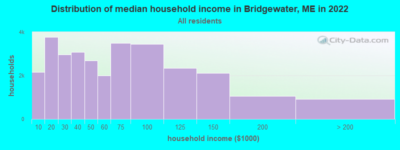
| Bridgewater: | $49,331 |
| ME: | $69,543 |
Estimated per capita income in 2022: $32,059 (it was $15,534 in 2000)
Bridgewater town income, earnings, and wages data
Estimated median house or condo value in 2022: $127,115 (it was $52,500 in 2000)
| Bridgewater: | $127,115 |
| ME: | $290,600 |
Mean prices in 2022: all housing units: $179,108; detached houses: $185,023; townhouses or other attached units: $218,327; in 2-unit structures: $262,505; in 3-to-4-unit structures: $121,406; in 5-or-more-unit structures: $185,084; mobile homes: $117,009; occupied boats, rvs, vans, etc.: $12,682
Detailed information about poverty and poor residents in Bridgewater, ME


- 59096.7%White alone
- 81.3%Two or more races
- 71.1%Hispanic
- 40.7%American Indian alone
- 10.2%Asian alone
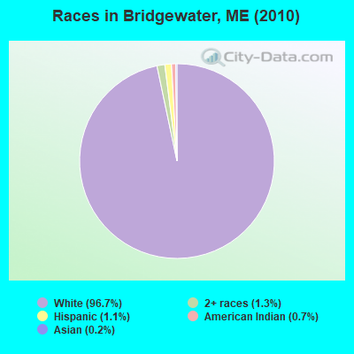
Races in Bridgewater detailed stats: ancestries, foreign born residents, place of birth
According to our research of Maine and other state lists, there was 1 registered sex offender living in Bridgewater, Maine as of May 09, 2024.
The ratio of all residents to sex offenders in Bridgewater is 610 to 1.
The ratio of registered sex offenders to all residents in this city is near the state average.
 Recent articles from our blog. Our writers, many of them Ph.D. graduates or candidates, create easy-to-read articles on a wide variety of topics.

 | Maine weather thread (3207 replies) |
| Maple syrup today compared to 25 years ago (33 replies) |
| Special Ed, medical care, land, newer builds (31 replies) |
| Stockholm Cell service (15 replies) |
| MOre Windmills!!! (18 replies) |
| Municipal Solid Waste: incinerators, landfills, out-of-state waste for profit, PERC, MRC (17 replies) |
Latest news from Bridgewater, ME collected exclusively by city-data.com from local newspapers, TV, and radio stations
Ancestries: United States (32.7%), English (22.1%), Irish (15.2%), French (8.2%), Scottish (7.7%), Dutch (3.4%).
Current Local Time: EST time zone
Incorporated on 03/02/1858
Elevation: 428 feet
Land area: 38.8 square miles.
Population density: 16 people per square mile (very low).
40 residents are foreign born (6.5% North America).
| This town: | 6.5% |
| Maine: | 2.9% |
| Bridgewater town: | 0.9% ($481) |
| Maine: | 1.5% ($1,417) |
Nearest city with pop. 50,000+: Portland, ME  (225.0 miles , pop. 64,249).
Nearest city with pop. 200,000+: Boston, MA (326.3 miles , pop. 589,141).
Nearest city with pop. 1,000,000+: Bronx, NY (489.9 miles , pop. 1,332,650).
Nearest cities:
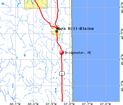
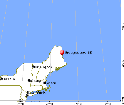
), ), ), ), ), Latitude: 46.43 N, Longitude: 67.84 W
Area code commonly used in this area: 207

| Here: | 2.7% |
| Maine: | 3.4% |
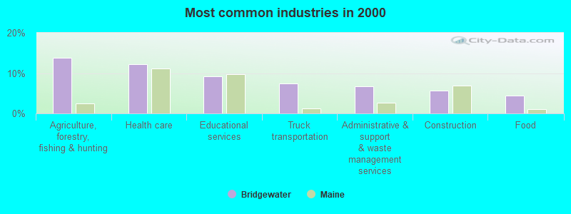
- Agriculture, forestry, fishing & hunting (13.9%)
- Health care (12.2%)
- Educational services (9.1%)
- Truck transportation (7.4%)
- Administrative & support & waste management services (6.8%)
- Construction (5.7%)
- Food (4.4%)
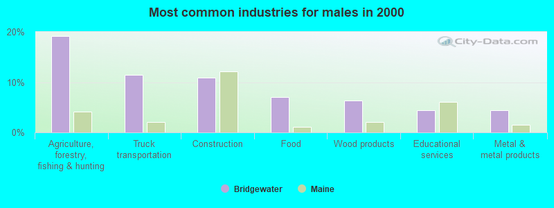
- Agriculture, forestry, fishing & hunting (19.1%)
- Truck transportation (11.5%)
- Construction (10.8%)
- Food (7.0%)
- Wood products (6.4%)
- Educational services (4.5%)
- Metal & metal products (4.5%)

- Health care (23.7%)
- Educational services (14.4%)
- Administrative & support & waste management services (11.5%)
- Agriculture, forestry, fishing & hunting (7.9%)
- Finance & insurance (6.5%)
- Accommodation & food services (5.0%)
- Broadcasting & telecommunications (4.3%)
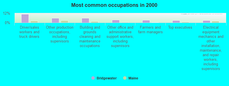
- Driver/sales workers and truck drivers (10.8%)
- Other production occupations, including supervisors (5.7%)
- Building and grounds cleaning and maintenance occupations (5.7%)
- Other office and administrative support workers, including supervisors (3.7%)
- Farmers and farm managers (3.4%)
- Top executives (3.0%)
- Electrical equipment mechanics and other installation, maintenance, and repair workers, including supervisors (3.0%)

- Driver/sales workers and truck drivers (20.4%)
- Other production occupations, including supervisors (9.6%)
- Building and grounds cleaning and maintenance occupations (5.1%)
- Fishing, hunting, and forestry occupations (5.1%)
- Carpenters (5.1%)
- Laborers and material movers, hand (5.1%)
- Farmers and farm managers (4.5%)

- Building and grounds cleaning and maintenance occupations (6.5%)
- Nursing, psychiatric, and home health aides (5.8%)
- Other office and administrative support workers, including supervisors (5.8%)
- Information and record clerks, except customer service representatives (4.3%)
- Cashiers (4.3%)
- Cooks and food preparation workers (4.3%)
- Secretaries and administrative assistants (4.3%)
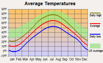
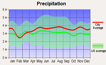
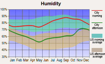
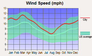
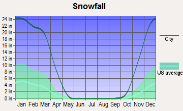
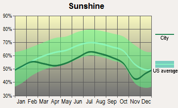
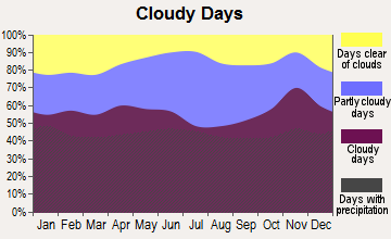
Average climate in Bridgewater, Maine
Based on data reported by over 4,000 weather stations
(lower is better)
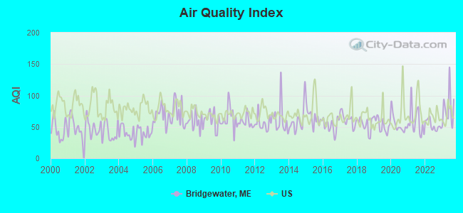
Air Quality Index (AQI) level in 2023 was 79.3. This is about average.
| City: | 79.3 |
| U.S.: | 72.6 |
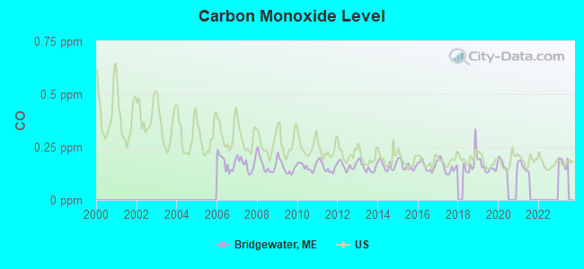
Carbon Monoxide (CO) [ppm] level in 2021 was 0.155. This is significantly better than average. Closest monitor was 20.5 miles away from the city center.
| City: | 0.155 |
| U.S.: | 0.251 |
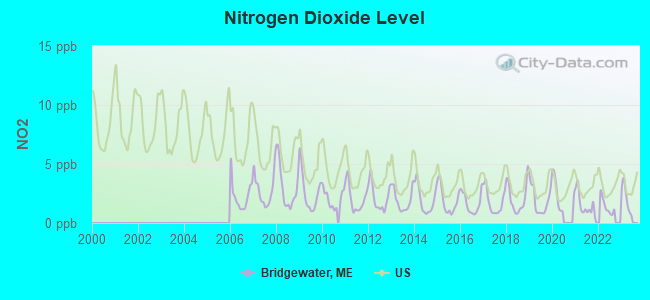
Nitrogen Dioxide (NO2) [ppb] level in 2022 was 1.41. This is significantly better than average. Closest monitor was 19.1 miles away from the city center.
| City: | 1.41 |
| U.S.: | 5.11 |
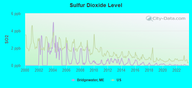
Sulfur Dioxide (SO2) [ppb] level in 2022 was 0.0234. This is significantly better than average. Closest monitor was 16.2 miles away from the city center.
| City: | 0.0234 |
| U.S.: | 1.5147 |
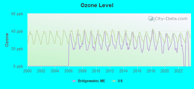
Ozone [ppb] level in 2022 was 27.2. This is better than average. Closest monitor was 19.1 miles away from the city center.
| City: | 27.2 |
| U.S.: | 33.3 |
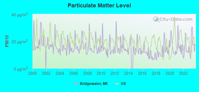
Particulate Matter (PM10) [µg/m3] level in 2023 was 19.0. This is about average. Closest monitor was 5.8 miles away from the city center.
| City: | 19.0 |
| U.S.: | 19.2 |
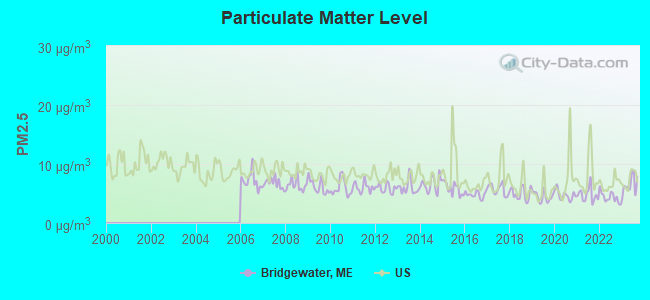
Particulate Matter (PM2.5) [µg/m3] level in 2023 was 6.45. This is better than average. Closest monitor was 19.3 miles away from the city center.
| City: | 6.45 |
| U.S.: | 8.11 |
Earthquake activity:
Bridgewater-area historical earthquake activity is above Maine state average. It is 86% smaller than the overall U.S. average.On 4/20/2002 at 10:50:47, a magnitude 5.3 (5.3 ML, Depth: 3.0 mi, Class: Moderate, Intensity: VI - VII) earthquake occurred 313.4 miles away from Bridgewater center
On 7/14/2006 at 09:34:48, a magnitude 3.9 (3.9 MD, Depth: 8.6 mi, Class: Light, Intensity: II - III) earthquake occurred 50.5 miles away from the city center
On 4/20/2002 at 10:50:47, a magnitude 5.2 (5.2 MB, 4.2 MS, 5.2 MW, 5.0 MW) earthquake occurred 315.1 miles away from the city center
On 10/16/2012 at 23:12:25, a magnitude 4.7 (4.7 ML, Depth: 10.0 mi, Class: Light, Intensity: IV - V) earthquake occurred 239.4 miles away from the city center
On 10/7/1983 at 10:18:46, a magnitude 5.3 (5.1 MB, 5.3 LG, 5.1 ML) earthquake occurred 360.0 miles away from Bridgewater center
On 1/19/1982 at 00:14:42, a magnitude 4.7 (4.5 MB, 4.7 MD, 4.5 LG) earthquake occurred 273.6 miles away from Bridgewater center
Magnitude types: regional Lg-wave magnitude (LG), body-wave magnitude (MB), duration magnitude (MD), local magnitude (ML), surface-wave magnitude (MS), moment magnitude (MW)
Natural disasters:
The number of natural disasters in Aroostook County (22) is greater than the US average (15).Major Disasters (Presidential) Declared: 13
Emergencies Declared: 9
Causes of natural disasters: Floods: 10, Storms: 8, Snows: 7, Heavy Rains: 2, Blizzard: 1, Hurricane: 1, Ice Storm: 1, Snowfall: 1, Snowstorm: 1, Wind: 1, Winter Storm: 1, Other: 2 (Note: some incidents may be assigned to more than one category).

Colleges/universities with over 2000 students nearest to Bridgewater:
- University of Maine (about 114 miles; Orono, ME; Full-time enrollment: 8,931)
- Husson University (about 120 miles; Bangor, ME; FT enrollment: 2,421)
- University of Maine at Farmington (about 166 miles; Farmington, ME; FT enrollment: 2,036)
- University of Maine at Augusta (about 174 miles; Augusta, ME; FT enrollment: 3,204)
- Saint Joseph's College of Maine (about 222 miles; Standish, ME; FT enrollment: 2,010)
- Southern Maine Community College (about 226 miles; South Portland, ME; FT enrollment: 4,666)
- University of Southern Maine (about 226 miles; Portland, ME; FT enrollment: 6,647)
Points of interest:
Notable locations in Bridgewater: Aroostook Campground (A), Bridgewater Fire Department (B). Display/hide their locations on the map
Cemeteries: Boundary Line Cemetery (1), Bridgewater Corner Cemetery (2), Smith Cemetery (3). Display/hide their locations on the map
Lakes: Whitehead Lake (A), Packard Lake (B), Portland Lake (C). Display/hide their locations on the map
Streams, rivers, and creeks: Whitney Brook (A), Russell Brook (B), Young Brook (C), Gin Brook (D), Dead Brook (E). Display/hide their locations on the map
| This town: | 2.3 people |
| Maine: | 2.3 people |
| This town: | 66.5% |
| Whole state: | 62.9% |
| This town: | 2.7% |
| Whole state: | 9.4% |
No gay or lesbian households reported
| This town: | 17.6% |
| Whole state: | 10.9% |
| This town: | 8.3% |
| Whole state: | 4.1% |
For population 15 years and over in Bridgewater:
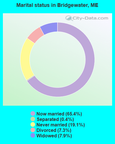
- Never married: 19.1%
- Now married: 65.4%
- Separated: 0.4%
- Widowed: 7.9%
- Divorced: 7.3%
For population 25 years and over in Bridgewater:
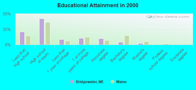
- High school or higher: 78.9%
- Bachelor's degree or higher: 6.7%
- Graduate or professional degree: 2.3%
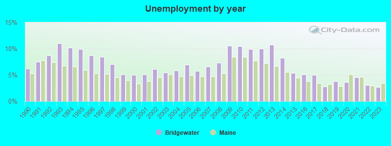
- Unemployed: 7.5%
- Mean travel time to work (commute): 21.9 minutes
| Here: | 9.3 |
| Maine average: | 11.2 |


Graphs represent county-level data. Detailed 2008 Election Results
Religion statistics for Bridgewater, ME (based on Aroostook County data)


| Religion | Adherents | Congregations |
|---|---|---|
| Catholic | 22,200 | 27 |
| Mainline Protestant | 5,845 | 40 |
| Evangelical Protestant | 4,411 | 51 |
| Other | 957 | 7 |
| Orthodox | 10 | 1 |
| None | 38,447 | - |
Food Environment Statistics:
| Aroostook County: | 4.03 / 10,000 pop. |
| State: | 2.80 / 10,000 pop. |
| Aroostook County: | 0.14 / 10,000 pop. |
| Maine: | 0.14 / 10,000 pop. |
| Aroostook County: | 2.22 / 10,000 pop. |
| Maine: | 2.20 / 10,000 pop. |
| Aroostook County: | 7.78 / 10,000 pop. |
| Maine: | 5.75 / 10,000 pop. |
| Aroostook County: | 9.17 / 10,000 pop. |
| Maine: | 11.02 / 10,000 pop. |
| Here: | 11.7% |
| Maine: | 8.2% |
| Here: | 27.6% |
| Maine: | 25.0% |
Businesses in Bridgewater, ME
- Circle K: 1
Strongest AM radio stations in Bridgewater:
- WREM (710 AM; daytime; 5 kW; MONTICELLO, ME; Owner: ALLAN H WEINER)
- WEGP (1390 AM; 5 kW; PRESQUE ISLE, ME; Owner: DECELLES/SMITH MEDIA, INC.)
- WFST (600 AM; 5 kW; CARIBOU, ME; Owner: NORTHERN BROADCAST MINISTRIES, INC.)
- WRKO (680 AM; 50 kW; BOSTON, MA; Owner: ENTERCOM BOSTON LICENSE, LLC)
- WCHP (760 AM; 35 kW; CHAMPLAIN, NY; Owner: CHAMPLAIN RADIO, INC.)
- WZON (620 AM; 5 kW; BANGOR, ME; Owner: THE ZONE CORPORATION)
- WEEI (850 AM; 50 kW; BOSTON, MA; Owner: ENTERCOM BOSTON LICENSE, LLC)
- WNNZ (640 AM; 50 kW; WESTFIELD, MA; Owner: CLEAR CHANNEL BROADCASTING LICENSES, INC.)
- WCRN (830 AM; 50 kW; WORCESTER, MA; Owner: CARTER BROADCASTING CORPORATION)
- WBZ (1030 AM; 50 kW; BOSTON, MA; Owner: INFINITY BROADCASTING OPERATIONS, INC.)
- WSKW (1160 AM; 10 kW; SKOWHEGAN, ME; Owner: MOUNTAIN WIRELESS, INCORPORATED)
- WGY (810 AM; 50 kW; SCHENECTADY, NY; Owner: CLEAR CHANNEL BROADCASTING LICENSES, INC.)
- WALE (990 AM; 50 kW; GREENVILLE, RI; Owner: NORTH AMERICAN BROADCASTING CO., INC.)
Strongest FM radio stations in Bridgewater:
- WQHR (96.1 FM; PRESQUE ISLE, ME; Owner: CITADEL BROADCASTING COMPANY)
- WOZI (101.9 FM; PRESQUE ISLE, ME; Owner: CITADEL BROADCASTING COMPANY)
- WMEM (106.1 FM; PRESQUE ISLE, ME; Owner: MAINE PUBLIC BROADCASTING CORPORATION)
- WBPW (96.9 FM; PRESQUE ISLE, ME; Owner: CITADEL BROADCASTING COMPANY)
- W274AF (102.7 FM; PRESQUE ISLE, ME; Owner: BANGOR BAPTIST CHURCH)
- WHOU-FM (100.1 FM; HOULTON, ME; Owner: COUNTY COMMUNICATIONS, INC.)
- WCXU (97.7 FM; CARIBOU, ME; Owner: THE CANXUS BROADCASTING CORPORATION)
TV broadcast stations around Bridgewater:
- WAGM-TV (Channel 8; PRESQUE ISLE, ME; Owner: NEPSK, INC.)
- WMEM-TV (Channel 10; PRESQUE ISLE, ME; Owner: MAINE PUBLIC BROADCASTING CORPORATION)
- Bridgewater, Maine
- Fatal accident count9
- Vehicles involved in fatal accidents12
- Fatal accidents involving drunk persons:5
- Fatalities9
- Persons involved in fatal accidents22
- Pedestrians involved in fatal accidents1
- Maine average
- Fatal accident count1563
- Vehicles involved in fatal accidents2199
- Fatal accidents involving drunk persons589
- Fatalities1736
- Persons involved in fatal accidents3737
- Pedestrians involved in fatal accidents114
- National Bridge Inventory (NBI) Statistics
- 3Number of bridges
- 16ft / 5.3mTotal length
- 5,113Total average daily traffic
- 255Total average daily truck traffic
- 7,273Total future (year 2036) average daily traffic
FCC Registered Broadcast Land Mobile Towers:
6- Number 9 Mountain Td R2 (Lat: 46.420889 Lon: -68.023083), Call Sign: KXA530,
Assigned Frequencies: 154.665 MHz, 154.710 MHz, 154.905 MHz, 155.415 MHz, Grant Date: 09/20/2001, Expiration Date: 11/25/2011, Cancellation Date: 05/05/2008, Registrant: State Of Maine, Office Of Information Technology, State House Station 145, Augusta, ME 04333, Phone: (207) 624-9933, Fax: (207) 287-4563, Email:
- 9 Mountain (Lat: 46.420889 Lon: -68.023083), Call Sign: WAM956,
Assigned Frequencies: 457.250 MHz, 457.450 MHz, 457.550 MHz, 457.600 MHz, 457.675 MHz, 457.975 MHz, Grant Date: 12/30/2000, Expiration Date: 01/02/2011, Cancellation Date: 05/05/2008, Registrant: State Of Maine, State House Station 145, Augusta, ME 04333-0145, Phone: (207) 624-9933, Fax: (207) 287-5623, Email:
- #9 Mountain (Lat: 46.420889 Lon: -68.023083), Type: Tower, Structure height: 33 m, Overall height: 35 m, Call Sign: WGT436,
Assigned Frequencies: 457.875 MHz, Grant Date: 04/07/2015, Expiration Date: 06/26/2025, Registrant: Aroostook County Emergency Management Agency, 158 Sweden Street, Caribou, ME 04736, Phone: (207) 493-4328, Fax: (207) 493-4357, Email:
- No 9 Mtn (Lat: 46.420889 Lon: -68.023083), Type: Tower, Structure height: 24 m, Overall height: 31 m, Call Sign: WPQY221,
Assigned Frequencies: 453.200 MHz, Grant Date: 11/18/2015, Expiration Date: 11/21/2025, Certifier: Joseph F Grimmig, Registrant: State Of Maine, O.I.T., Radio Operations, 66 Industrial Drive, Augusta, ME 04333-0147, Phone: (207) 624-9990, Email:
- Number 9 Mtn (Lat: 46.420833 Lon: -68.023611), Type: Tower, Structure height: 24 m, Overall height: 31 m, Call Sign: WPTB420,
Assigned Frequencies: 458.200 MHz, Grant Date: 05/28/2021, Expiration Date: 08/22/2031, Certifier: Joseph F Grimmig, Registrant: State Of Maine, O.I.T., Radio Operations, 66 Industrial Drive, Augusta, ME 04333-0147, Phone: (207) 624-9990, Email:
- Number 9 Mountain (Lat: 46.419361 Lon: -68.016806), Type: Tower, Structure height: 54 m, Overall height: 58 m, Call Sign: WQJJ777,
Assigned Frequencies: 158.730 MHz, Grant Date: 07/18/2018, Expiration Date: 10/03/2028, Certifier: Mark W Poole, Registrant: State Of Maine, O.I.T., Radio Operations, 66 Industrial Drive, Augusta, ME 04333-0147, Phone: (207) 624-9990, Email:
FCC Registered Microwave Towers:
1- NO 9 MTN, No. 9 Mountain (Lat: 46.421000 Lon: -68.024389), Type: Mast, Structure height: 54.9 m, Call Sign: WQNX358,
Assigned Frequencies: 942.175 MHz, 942.575 MHz, 6063.80 MHz, 6034.15 MHz, 5945.20 MHz, 5945.20 MHz, 6152.75 MHz, 6034.15 MHz, 6615.00 MHz, 6635.00 MHz... (+36 more), Grant Date: 04/07/2021, Expiration Date: 06/24/2031, Certifier: David E Mars, Registrant: State Of Maine, O.I.T., Radio Operations, 66 Industrial Drive, Augusta, ME 04333-0147, Phone: (207) 624-9990, Email:
FCC Registered Amateur Radio Licenses:
4- Call Sign: N1YIT, Grant Date: 12/24/1996, Expiration Date: 12/24/2006, Cancellation Date: 12/25/2008, Registrant: Ira L Scherr, Rr 1 Box 27, Bridgewater, ME 04735
- Call Sign: KC9TVD, Licensee ID: L01625205, Grant Date: 01/27/2021, Expiration Date: 03/17/2031, Certifier: Jonathan A Collins, Registrant: Jonathan A Collins, 130 Montieth Road, Bridgewater, ME 04735
- Call Sign: KC1BQW, Licensee ID: L01860169, Grant Date: 04/23/2014, Expiration Date: 04/23/2024, Certifier: Laurel A Livesey, Registrant: Laurel A Livesey, 183 Boundary Line Rd, Bridgewater, ME 04735
- Call Sign: KC1BRA, Licensee ID: L01860174, Grant Date: 04/23/2014, Expiration Date: 04/23/2024, Certifier: Daniel N Livesey, Registrant: Daniel N Livesey, 165 Snow Rd, Bridgewater, ME 04735
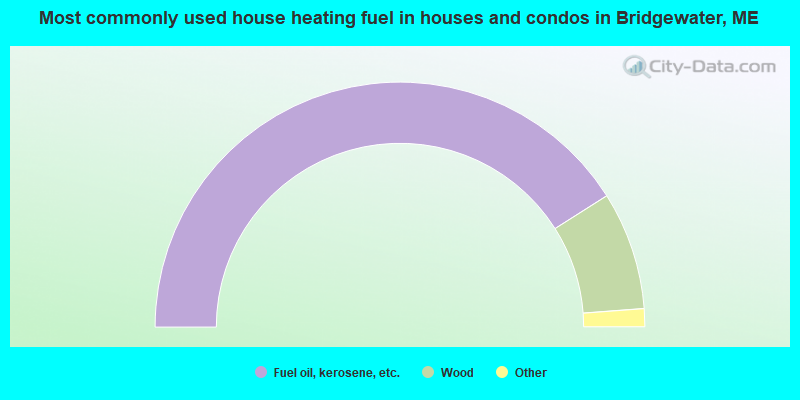
- 82.1%Fuel oil, kerosene, etc.
- 15.6%Wood
- 1.4%Electricity
- 0.9%Bottled, tank, or LP gas
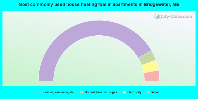
- 83.3%Fuel oil, kerosene, etc.
- 5.6%Bottled, tank, or LP gas
- 5.6%Electricity
- 5.6%Wood
Bridgewater compared to Maine state average:
- Median house value significantly below state average.
- Unemployed percentage below state average.
- Black race population percentage significantly below state average.
- Hispanic race population percentage below state average.
- Foreign-born population percentage above state average.
- Renting percentage below state average.
- Length of stay since moving in significantly above state average.
- Number of rooms per house significantly below state average.
- House age significantly below state average.
- Percentage of population with a bachelor's degree or higher significantly below state average.
Bridgewater on our top lists:
- #32 on the list of "Top 101 cities with the most residents born in Northern America (population 500+)"
- #32 on the list of "Top 101 cities with the most residents born in Canada (population 500+)"
- #19 on the list of "Top 101 counties with the highest carbon monoxide air pollution readings in 2012 (ppm)"
- #22 on the list of "Top 101 counties with the smallest number of children under 18 without health insurance coverage in 2000 (pop. 50,000+)"
- #29 on the list of "Top 101 counties with the lowest percentage of residents relocating from other counties between 2010 and 2011"
- #34 on the list of "Top 101 counties with the lowest percentage of residents relocating to other counties in 2011"
- #46 on the list of "Top 101 counties with the lowest Particulate Matter (PM2.5) Annual air pollution readings in 2012 (µg/m3)"