Webb, Texas
Submit your own pictures of this place and show them to the world
- OSM Map
- General Map
- Google Map
- MSN Map

| Males: 5,895 | |
| Females: 5,647 |
| Median resident age: | 26.9 years |
| Texas median age: | 32.3 years |
Zip code: 78019
| Webb: | $102,466 |
| TX: | $72,284 |
Estimated per capita income in 2022: $39,594 (it was $17,398 in 2000)
Webb CCD income, earnings, and wages data
Estimated median house or condo value in 2022: $255,011 (it was $99,800 in 2000)
| Webb: | $255,011 |
| TX: | $275,400 |
Mean prices in 2022: all housing units: $219,077; detached houses: $229,501; townhouses or other attached units: $168,368; in 2-unit structures: $294,123; in 3-to-4-unit structures: $134,959; in 5-or-more-unit structures: $159,407; mobile homes: $154,373; occupied boats, rvs, vans, etc.: $57,294
Detailed information about poverty and poor residents in Webb, TX


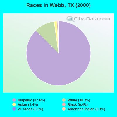
- 8,51887.6%Hispanic
- 99810.3%White alone
- 1331.4%Asian alone
- 380.4%Black alone
- 270.3%Two or more races
- 110.1%American Indian alone
- 10.01%Native Hawaiian and Other
Pacific Islander alone
Races in Webb detailed stats: ancestries, foreign born residents, place of birth
 Recent articles from our blog. Our writers, many of them Ph.D. graduates or candidates, create easy-to-read articles on a wide variety of topics.
Current Local Time: CST time zone
Land area: 2222.4 square miles.
Population density: 5.2 people per square mile (very low).

| Webb CCD: | 2.1% ($2,117) |
| Texas: | 1.8% ($1,393) |
Nearest city with pop. 50,000+: Laredo, TX  (23.3 miles , pop. 176,576).
Nearest city with pop. 200,000+: San Antonio, TX (124.3 miles , pop. 1,144,646).
Nearest cities:
), Latitude: 27.86 N, Longitude: 99.46 W
Area code commonly used in this area: 956

| Here: | 3.5% |
| Texas: | 3.5% |
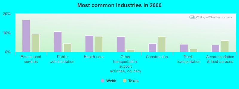
- Educational services (16.7%)
- Public administration (10.7%)
- Health care (8.6%)
- Other transportation, support activities, couriers (8.1%)
- Construction (4.5%)
- Truck transportation (4.0%)
- Accommodation & food services (3.8%)
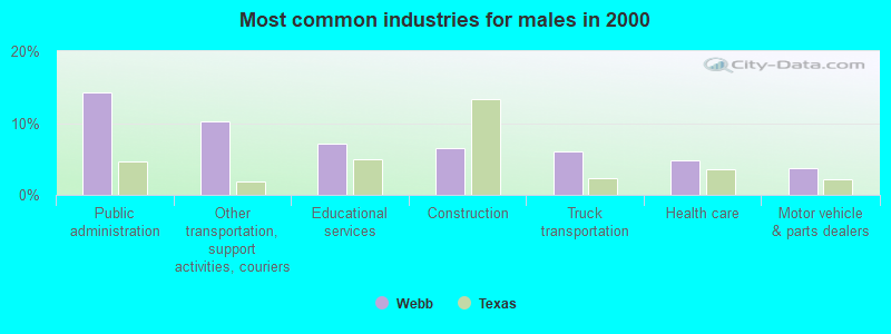
- Public administration (14.2%)
- Other transportation, support activities, couriers (10.2%)
- Educational services (7.2%)
- Construction (6.5%)
- Truck transportation (6.1%)
- Health care (4.9%)
- Motor vehicle & parts dealers (3.7%)
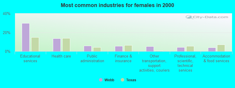
- Educational services (29.7%)
- Health care (13.8%)
- Public administration (5.8%)
- Finance & insurance (5.5%)
- Other transportation, support activities, couriers (5.2%)
- Professional, scientific, technical services (4.4%)
- Accommodation & food services (3.9%)
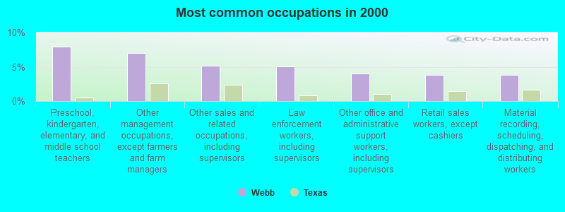
- Preschool, kindergarten, elementary, and middle school teachers (7.9%)
- Other management occupations, except farmers and farm managers (7.0%)
- Other sales and related occupations, including supervisors (5.1%)
- Law enforcement workers, including supervisors (5.1%)
- Other office and administrative support workers, including supervisors (4.1%)
- Retail sales workers, except cashiers (3.8%)
- Material recording, scheduling, dispatching, and distributing workers (3.8%)
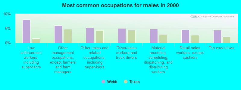
- Law enforcement workers, including supervisors (8.0%)
- Other management occupations, except farmers and farm managers (6.0%)
- Other sales and related occupations, including supervisors (5.2%)
- Driver/sales workers and truck drivers (5.0%)
- Material recording, scheduling, dispatching, and distributing workers (4.8%)
- Retail sales workers, except cashiers (4.5%)
- Top executives (4.4%)
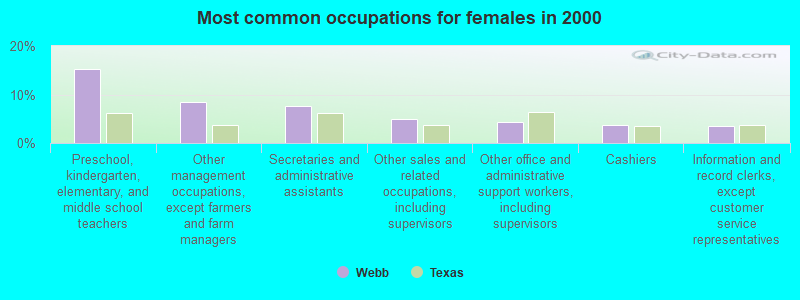
- Preschool, kindergarten, elementary, and middle school teachers (15.3%)
- Other management occupations, except farmers and farm managers (8.4%)
- Secretaries and administrative assistants (7.7%)
- Other sales and related occupations, including supervisors (4.9%)
- Other office and administrative support workers, including supervisors (4.4%)
- Cashiers (3.7%)
- Information and record clerks, except customer service representatives (3.5%)
Average climate in Webb, Texas
Based on data reported by over 4,000 weather stations


(lower is better)
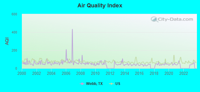
Air Quality Index (AQI) level in 2021 was 51.7. This is significantly better than average.
| City: | 51.7 |
| U.S.: | 72.6 |
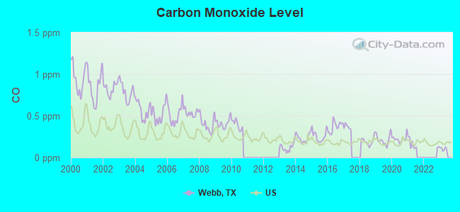
Carbon Monoxide (CO) [ppm] level in 2021 was 0.167. This is significantly better than average. Closest monitor was 24.7 miles away from the city center.
| City: | 0.167 |
| U.S.: | 0.251 |
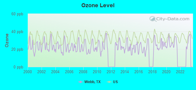
Ozone [ppb] level in 2021 was 28.3. This is about average. Closest monitor was 24.7 miles away from the city center.
| City: | 28.3 |
| U.S.: | 33.3 |
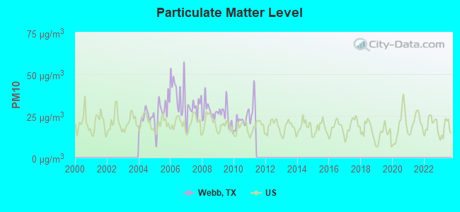
Particulate Matter (PM10) [µg/m3] level in 2010 was 22.3. This is about average. Closest monitor was 23.6 miles away from the city center.
| City: | 22.3 |
| U.S.: | 19.2 |
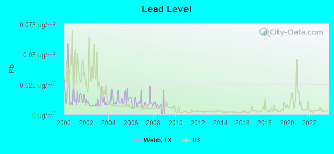
Lead (Pb) [µg/m3] level in 2008 was 0.00900. This is about average. Closest monitor was 21.0 miles away from the city center.
| City: | 0.00900 |
| U.S.: | 0.00931 |
Earthquake activity:
Webb-area historical earthquake activity is significantly above Texas state average. It is 38% smaller than the overall U.S. average.On 10/20/2011 at 12:24:41, a magnitude 4.8 (4.8 MW, Depth: 3.1 mi, Class: Light, Intensity: IV - V) earthquake occurred 109.2 miles away from Webb center
On 4/14/1995 at 00:32:56, a magnitude 5.7 (5.6 MB, 5.7 MS, 5.7 MW, Depth: 11.1 mi, Class: Moderate, Intensity: VI - VII) earthquake occurred 289.2 miles away from the city center
On 4/9/1993 at 12:29:19, a magnitude 4.3 (4.1 MB, 4.3 LG, Depth: 3.1 mi) earthquake occurred 104.8 miles away from Webb center
On 5/1/2018 at 16:28:56, a magnitude 4.0 (4.0 MW, Depth: 3.1 mi) earthquake occurred 116.5 miles away from the city center
On 4/25/2010 at 02:10:42, a magnitude 3.9 (3.9 MB, Depth: 3.1 mi, Class: Light, Intensity: II - III) earthquake occurred 99.6 miles away from Webb center
On 3/24/1997 at 22:31:34, a magnitude 3.8 (3.8 LG, Depth: 3.1 mi) earthquake occurred 86.8 miles away from Webb center
Magnitude types: regional Lg-wave magnitude (LG), body-wave magnitude (MB), surface-wave magnitude (MS), moment magnitude (MW)
Natural disasters:
The number of natural disasters in Webb County (16) is near the US average (15).Major Disasters (Presidential) Declared: 7
Emergencies Declared: 7
Causes of natural disasters: Hurricanes: 7, Fires: 3, Tropical Storms: 3, Floods: 2, Storms: 2, Tornado: 1, Other: 1 (Note: some incidents may be assigned to more than one category).
Colleges/universities with over 2000 students nearest to Webb:
- Texas A & M International University (about 20 miles; Laredo, TX; Full-time enrollment: 5,203)
- Laredo Community College (about 25 miles; Laredo, TX; FT enrollment: 9,743)
- Southwest Texas Junior College (about 96 miles; Uvalde, TX; FT enrollment: 3,569)
- Texas A & M University-Kingsville (about 100 miles; Kingsville, TX; FT enrollment: 9,295)
- Coastal Bend College (about 112 miles; Beeville, TX; FT enrollment: 2,880)
- Palo Alto College (about 116 miles; San Antonio, TX; FT enrollment: 5,055)
- Northwest Vista College (about 121 miles; San Antonio, TX; FT enrollment: 9,683)
Points of interest:
Notable locations in Webb: Jefferies Ranch (A), Apache Ranch (B), Hilltop Ranch (C), A Schletze (D), Alexander Ranch (E), Altos Windmill (F), Apache Ranch (G), B Dunbar (H), Bell Ranch (I), Bennet Ranch (J), Borden Camp (K), Brewster Ranch (L), Brown Ranch (M), Bruni Ranch (N), Buena Vista Ranch (O), C Chenault (P), Callaghan Ranch (Q), Casa Blanca Ranch (R), Chupadera Ranch (S), Cibolo Ranch (T). Display/hide their locations on the map
Church in Webb: Iglesia Bautista - Nueva Vida Church (A). Display/hide its location on the map
Cemeteries: Becerra Cemetery (1), Cactus Cemetery (2), Darwin Cemetery (3), Dolores Cemetery (4), Tordillo Cemetery (5). Display/hide their locations on the map
Reservoirs: Woodpecker Tank (A), Wonder Tank (B), Windmill Pit Tank (C), Willow Tank (D), North Apache Ranch Lake (E), South Apache Ranch Lake (F), Traylor Lake Number 2 (G), Nunley Lake Number 2 (H). Display/hide their locations on the map
Streams, rivers, and creeks: Venado Creek (A), Tordillo Creek (B), Tios Creek (C), Tejones Creek (D), Santa Isabel Creek (E), San Ygnacio Creek (F), San Lorenzo Creek (G), San Cirilo Creek (H), San Carlos Creek (I). Display/hide their locations on the map
Parks in Webb include: Laredo Entertainment Center (1), Krueger Field (2). Display/hide their locations on the map
Birthplace of: Royce Womble - Football player.
| This place: | 3.5 people |
| Texas: | 2.7 people |
| This place: | 74.0% |
| Whole state: | 71.5% |
| This place: | 2.8% |
| Whole state: | 4.4% |
Likely homosexual households (counted as self-reported same-sex unmarried-partner households)
- Lesbian couples: 0.2% of all households
- Gay men: 0.3% of all households
| This place: | 13.7% |
| Whole state: | 15.4% |
| This place: | 5.4% |
| Whole state: | 6.7% |
22 people in agriculture workers' dormitories on farms in 2000
For population 15 years and over in Webb:
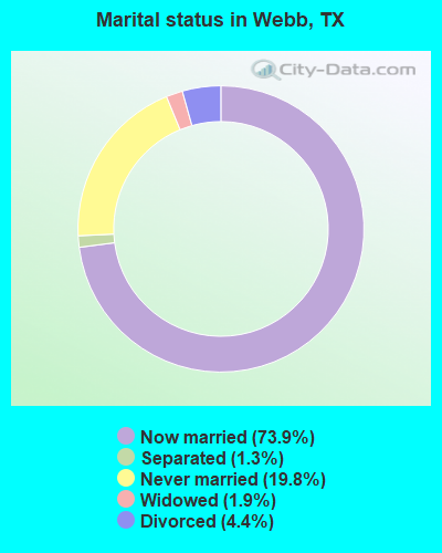
- Never married: 19.8%
- Now married: 73.9%
- Separated: 1.3%
- Widowed: 1.9%
- Divorced: 4.4%
For population 25 years and over in Webb:
- High school or higher: 74.6%
- Bachelor's degree or higher: 28.5%
- Graduate or professional degree: 9.3%
- Unemployed: 2.8%
- Mean travel time to work (commute): 19.9 minutes
| Here: | 16.8 |
| Texas average: | 15.6 |
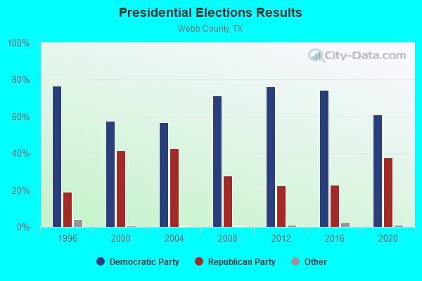
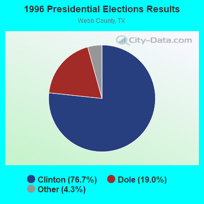
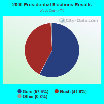

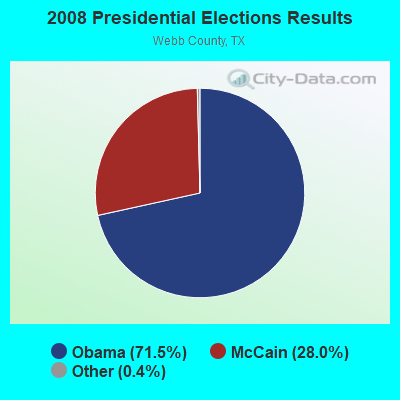
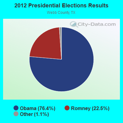
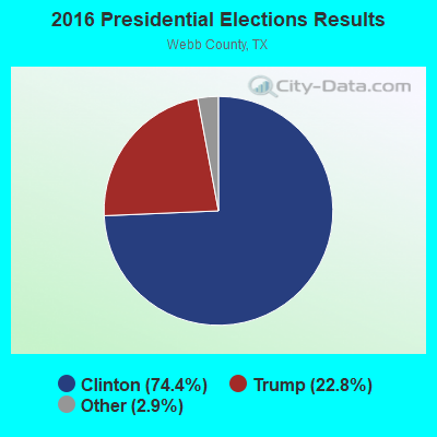
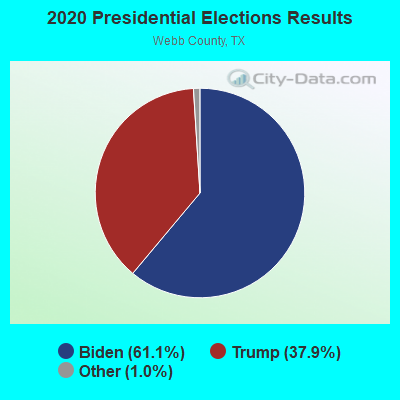
Graphs represent county-level data. Detailed 2008 Election Results
Religion statistics for Webb, TX (based on Webb County data)
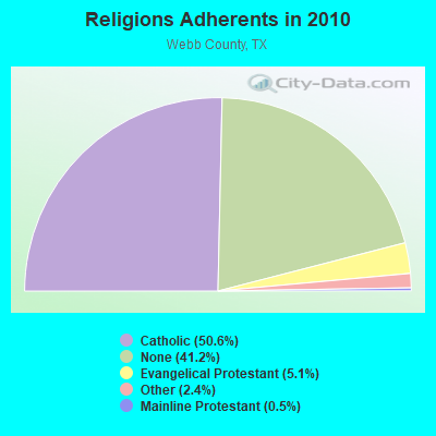
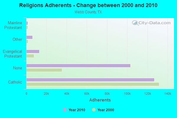
| Religion | Adherents | Congregations |
|---|---|---|
| Catholic | 126,750 | 26 |
| Evangelical Protestant | 12,812 | 90 |
| Other | 6,120 | 12 |
| Mainline Protestant | 1,354 | 9 |
| Black Protestant | 207 | 1 |
| None | 103,061 | - |
Food Environment Statistics:
| Webb County: | 1.86 / 10,000 pop. |
| State: | 1.47 / 10,000 pop. |
| Webb County: | 0.17 / 10,000 pop. |
| Texas: | 0.14 / 10,000 pop. |
| This county: | 0.43 / 10,000 pop. |
| Texas: | 1.11 / 10,000 pop. |
| Webb County: | 3.80 / 10,000 pop. |
| State: | 3.95 / 10,000 pop. |
| This county: | 5.57 / 10,000 pop. |
| Texas: | 6.13 / 10,000 pop. |
| This county: | 9.1% |
| Texas: | 8.9% |
| This county: | 28.0% |
| Texas: | 26.6% |
| Webb County: | 15.4% |
| Texas: | 15.7% |
2.21% of this county's 2021 resident taxpayers lived in other counties in 2020 ($44,945 average adjusted gross income)
| Here: | 2.21% |
| Texas average: | 8.12% |
0.02% of residents moved from foreign countries ($549 average AGI)
Webb County: 0.02% Texas average: 0.04%
Top counties from which taxpayers relocated into this county between 2020 and 2021:
| from Bexar County, TX | |
| from Harris County, TX | |
| from Hidalgo County, TX |
Strongest AM radio stations in Webb:
- KVOZ (890 AM; 12 kW; DEL MAR HILLS, TX; Owner: CONSOLIDATED RADIO, INC.)
- KKYX (680 AM; 50 kW; SAN ANTONIO, TX; Owner: CXR HOLDINGS, INC.)
- KTKR (760 AM; 50 kW; SAN ANTONIO, TX; Owner: CCB TEXAS LICENSES, L.P.)
- KCTA (1030 AM; 50 kW; CORPUS CHRISTI, TX; Owner: BROADCASTING CORPORATION OF THE SOUTHWEST)
- WOAI (1200 AM; 50 kW; SAN ANTONIO, TX; Owner: CCB TEXAS LICENSES, L.P.)
- KGBT (1530 AM; 50 kW; HARLINGEN, TX; Owner: TICHENOR LICENSE CORPORATION)
- KENS (1160 AM; 25 kW; SAN ANTONIO, TX; Owner: KENS-TV, INC.)
- KLAR (1300 AM; 1 kW; LAREDO, TX; Owner: FAITH AND POWER COMMS., INC.)
- KLNT (1490 AM; 1 kW; LAREDO, TX; Owner: AMIGO RADIO, LTD.)
- KURV (710 AM; 10 kW; EDINBURG, TX; Owner: VOICE OF VALLEY AGRICULTURE, INC.)
- KSAH (720 AM; 10 kW; UNIVERSAL CITY, TX; Owner: KSAH LICENSING, INC.)
- KTRH (740 AM; 50 kW; HOUSTON, TX; Owner: AMFM TEXAS LICENSES LIMITED PARTNERSHIP)
- KDRY (1100 AM; 11 kW; ALAMO HEIGHTS, TX; Owner: KDRY RADIO, INC.)
Strongest FM radio stations in Webb:
- KBNL (89.9 FM; LAREDO, TX; Owner: WORLD RADIO NETWORK, INC.)
- KQUR (94.9 FM; LAREDO, TX; Owner: BORDER BROADCASTERS, INC.)
- KRRG (98.1 FM; LAREDO, TX; Owner: GUERRA ENTERPRISES)
- KBDR-FM1 (100.5 FM; LAREDO, TX; Owner: BMP 100.5 FM, LP)
- KHOY (88.1 FM; LAREDO, TX; Owner: LAREDO CATHOLIC COMMUNICATIONS, INC.)
- KJBZ (92.7 FM; LAREDO, TX; Owner: GUERRA ENTERPRISES)
TV broadcast stations around Webb:
- KGNS-TV (Channel 8; LAREDO, TX; Owner: CENTURY DEVELOPMENT CORPORATION)
- KVTV (Channel 13; LAREDO, TX; Owner: EAGLE CREEK BROADCASTING OF LAREDO, LLC)
- KLMV-LP (Channel 68; LAREDO, TX; Owner: J. B. SALAZAR)
FCC Registered Antenna Towers:
10 (See the full list of FCC Registered Antenna Towers in Webb)FCC Registered Commercial Land Mobile Towers:
1- Herd Ranch (Lat: 27.549472 Lon: -99.372806), Structure height: 61 m, Call Sign: KPJ347,
Assigned Frequencies: 450.010 MHz, Grant Date: 06/03/1986, Expiration Date: 08/01/1997, Cancellation Date: 09/24/2000, Registrant: Corrie Corp., 325 W. Hutchison, San Marcos, TX 78666
FCC Registered Broadcast Land Mobile Towers:
3- Webb, Lat: 27.779389 Lon: -99.420778, Call Sign: WQBB491,
Assigned Frequencies: 30.8400 MHz, 31.2400 MHz, 31.3200 MHz, 31.3600 MHz, 31.4000 MHz, 31.5600 MHz, 33.1400 MHz, 33.1600 MHz, 33.4000 MHz, 35.0200 MHz... (+54 more), Grant Date: 09/14/2004, Expiration Date: 09/14/2014, Cancellation Date: 11/15/2014, Certifier: Linda J Neat, Registrant: Lerman Senter Pllc, 2000 K Street, N.W., Suite 600, Washington, DC 20006, Phone: (202) 416-6749, Fax: (202) 293-7783, Email:
- 14 Miles Ne Of Webb (Lat: 27.863333 Lon: -99.212222), Call Sign: WQOK259,
Assigned Frequencies: 159.510 MHz, 159.900 MHz, Grant Date: 10/24/2011, Expiration Date: 10/24/2021, Cancellation Date: 12/25/2021, Certifier: Jim R Warren, Registrant: Business Radio Licensing, 30251 Golden Lantern, Suite E# 501, Laguna Niguel, CA 92677, Phone: (949) 348-8510, Fax: (949) 348-8514, Email:
- MP 389.7, Mp 389.7, Laredo Sub (Lat: 27.815194 Lon: -99.416056), Type: Bant, Structure height: 4 m, Call Sign: WQRJ569,
Assigned Frequencies: 160.470 MHz, 160.740 MHz, 160.515 MHz, Grant Date: 04/20/2023, Expiration Date: 05/29/2033, Certifier: Thomas J Mcgovern, Registrant: Concentrix, 222 So 15th St. Suite 505n, Omaha, NE 68102, Phone: (402) 262-4785, Email:
FCC Registered Microwave Towers:
3- STATION, 14 Mi Ne Of (Lat: 27.867222 Lon: -99.222806), Overall height: 92.4 m, Call Sign: WNEX748,
Assigned Frequencies: 928.968 MHz, 959.968 MHz, Grant Date: 09/30/1998, Expiration Date: 09/30/2008, Cancellation Date: 05/22/2008, Phone: (214) 951-4676
- Stanley CGF, Stanley Cgf (Lat: 28.155056 Lon: -99.686778), Type: Ltower, Structure height: 58 m, Call Sign: WQOP357,
Assigned Frequencies: 11385.0 MHz, 11345.0 MHz, 11305.0 MHz, 11245.0 MHz, 11485.0 MHz, 11245.0 MHz, 11485.0 MHz, 11245.0 MHz, 11485.0 MHz, 11245.0 MHz... (+17 more), Grant Date: 09/29/2021, Expiration Date: 12/07/2031, Certifier: Neeraj Vijay, Registrant: Sidley Austin LLP, 1501 K Street Nw, Washington, DC 20005, Phone: (202) 736-8417, Email:
- 4.7 Mi Nw Of (Lat: 27.832222 Lon: -99.471139), Structure height: 73.2 m, Call Sign: KHH28, Licensee ID: L00007862,
Assigned Frequencies: 7000.00 MHz, Grant Date: 06/14/1973, Expiration Date: 08/01/2006, Cancellation Date: 08/18/1999, Registrant: Western Communications Inc, 102 W Delmar Blvd, Laredo, TX 78040
2006 - 2017 National Fire Incident Reporting System (NFIRS) incidents
- Fire incident types reported to NFIRS in Webb, TX
- 38782.3%Outside Fires
- 5411.5%Mobile Property/Vehicle Fires
- 296.2%Structure Fires
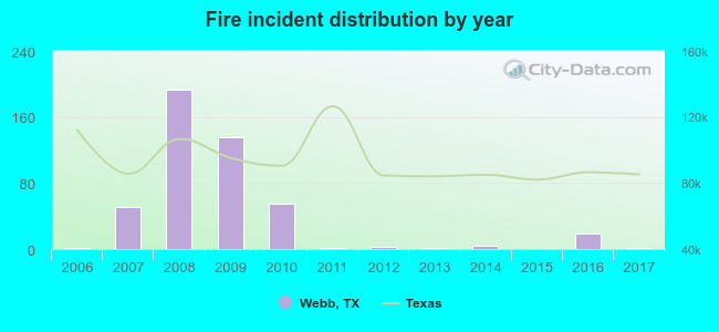 Based on the data from the years 2006 - 2017 the average number of fires per year is 39. The highest number of reported fires - 193 took place in 2008, and the least - 0 in 2015. The data has a constant trend.
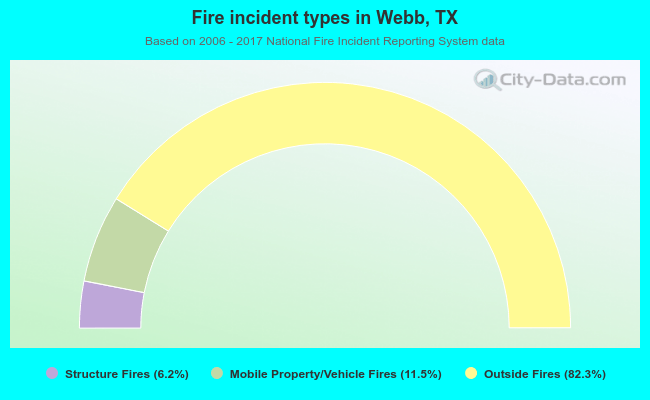 When looking into fire subcategories, the most incidents belonged to: Outside Fires (82.3%), and Mobile Property/Vehicle Fires (11.5%).
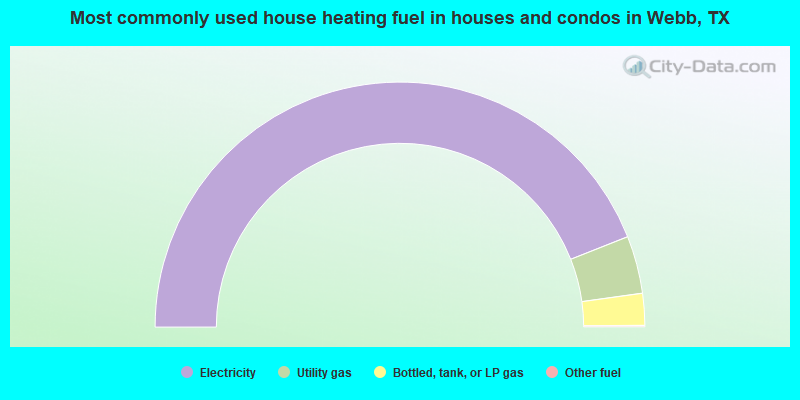
- 88.0%Electricity
- 7.6%Utility gas
- 4.2%Bottled, tank, or LP gas
- 0.2%Other fuel
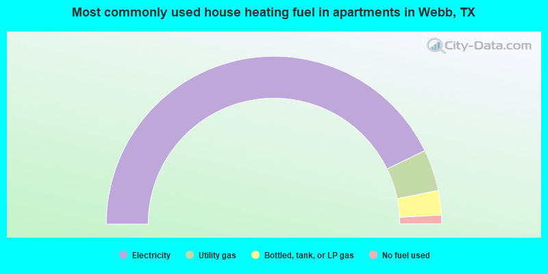
- 85.6%Electricity
- 8.0%Utility gas
- 4.7%Bottled, tank, or LP gas
- 1.7%No fuel used
Webb compared to Texas state average:
- Unemployed percentage significantly below state average.
- Black race population percentage significantly below state average.
- Hispanic race population percentage above state average.
- Foreign-born population percentage significantly below state average.
- Renting percentage significantly below state average.
- Length of stay since moving in significantly above state average.
- Number of rooms per house significantly below state average.
- House age significantly below state average.
- Institutionalized population percentage significantly above state average.
Webb on our top lists:
- #1 on the list of "Top 101 cities with largest percentage of females in occupations: preschool, kindergarten, elementary and middle school teachers (population 5,000+)"
- #1 on the list of "Top 101 cities with largest percentage of males in industries: other transportation, and support activities, and couriers (population 5,000+)"
- #1 on the list of "Top 101 cities with largest percentage of females in industries: other transportation, and support activities, and couriers (population 5,000+)"
- #3 on the list of "Top 101 cities with largest percentage of females in occupations: secondary school teachers (population 5,000+)"
- #4 on the list of "Top 101 cities with largest percentage of males in industries: miscellaneous durable goods merchant wholesalers (population 5,000+)"
- #5 on the list of "Top 101 cities with largest percentage of females in occupations: other transportation workers (population 5,000+)"
- #8 on the list of "Top 101 cities with largest percentage of females in occupations: other management occupations except farmers and farm managers (population 5,000+)"
- #22 on the list of "Top 101 cities with largest percentage of males in occupations: occupational and physical therapist assistants and aides (population 5,000+)"
- #28 on the list of "Top 101 cities with largest percentage of females in occupations: other protective service workers including supervisors (population 5,000+)"
- #35 on the list of "Top 101 cities with largest percentage of females in industries: electrical and electronic goods merchant wholesalers (population 5,000+)"
- #40 on the list of "Top 101 cities with largest percentage of males in industries: truck transportation (population 5,000+)"
- #41 on the list of "Top 100 cities with largest land areas"
- #43 on the list of "Top 101 cities with the largest percentage of people in federal prisons and detention centers (population 1,000+)"
- #43 on the list of "Top 101 cities with largest percentage of females in industries: office supplies and stationery stores (population 5,000+)"
- #72 on the list of "Top 101 cities with largest percentage of males in industries: other direct selling establishments (population 5,000+)"
- #86 on the list of "Top 101 cities with largest percentage of females in industries: truck transportation (population 5,000+)"
- #87 on the list of "Top 101 cities with largest percentage of females in industries: motor vehicles, parts and supplies merchant wholesalers (population 5,000+)"
- #91 on the list of "Top 101 cities with largest percentage of males in industries: rail transportation (population 5,000+)"
- #1 on the list of "Top 101 counties with the lowest percentage of residents relocating to other counties in 2011"
- #3 on the list of "Top 101 counties with the lowest percentage of residents relocating from other counties between 2010 and 2011"
- #3 on the list of "Top 101 counties with the highest number of births per 1000 residents 2007-2013"
- #23 on the list of "Top 101 counties with highest percentage of residents voting for Obama (Democrat) in the 2012 Presidential Election (pop. 50,000+)"
- #23 on the list of "Top 101 counties with the largest decrease in the number of births per 1000 residents 2000-2006 to 2007-2013 (pop 50,000+)"