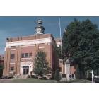
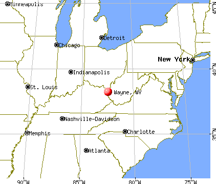
Wayne, West Virginia
Submit your own pictures of this town and show them to the world
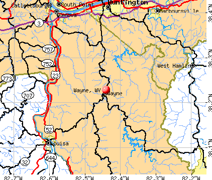
- OSM Map
- General Map
- Google Map
- MSN Map
Population change since 2000: +27.1%
| Males: 517 | |
| Females: 888 |
| Median resident age: | 39.2 years |
| West Virginia median age: | 42.9 years |
Zip codes: 25570.
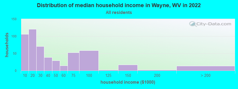
| Wayne: | $24,983 |
| WV: | $54,329 |
Estimated per capita income in 2022: $22,951 (it was $11,626 in 2000)
Wayne town income, earnings, and wages data
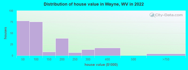
Estimated median house or condo value in 2022: $88,720 (it was $51,300 in 2000)
| Wayne: | $88,720 |
| WV: | $155,100 |
Mean prices in 2022: all housing units: $121,031; detached houses: $126,703; mobile homes: $49,430
Median gross rent in 2022: $650.
(21.0% for White Non-Hispanic residents, 100.0% for Black residents, 100.0% for two or more races residents)
Detailed information about poverty and poor residents in Wayne, WV
Compare current foreclosures near Wayne, WV:
| Photo | Address | Area | Beds / Baths | Price | Details |
|---|---|---|---|---|---|

|
#1
Olivia Jamison Rd
Wayne, WV 25570
|
- sq. feet
|
2 baths 3 beds |
$72,800
|
show details |

|
#2
1 Box 1432
Wayne, WV 25570
|
- sq. feet
|
1 baths 3 beds |
show details | |

|
#3
Oxyoke Hollow Ln
Wayne, WV 25570
|
- sq. feet
|
- baths - beds |
show details | |

|
#4
Newcomb Creek Rd
Wayne, WV 25570
|
- sq. feet
|
- baths - beds |
show details | |

|
#5
Route 75
Kenova, WV 25530
|
1,580 sq. feet
|
2 baths 3 beds |
$174,995
|
show details |

|
#6
Jackson Ave
Huntington, WV 25704
|
1,450 sq. feet
|
2 baths 2 beds |
$145,000
|
show details |

|
#7
& 3328 Crane Avenue
Huntington, WV 25705
|
950 sq. feet
|
1 baths 3 beds |
$42,500
|
show details |

|
#8
Walnut St
Kenova, WV 25530
|
2,063 sq. feet
|
2 baths 4 beds |
$225,000
|
show details |

|
#9
Township Rd 1007
Chesapeake, OH 45619
|
1,560 sq. feet
|
2 baths 3 beds |
$54,500
|
show details |

|
#10
Valley St
Catlettsburg, KY 41129
|
1,324 sq. feet
|
1 baths 3 beds |
$115,000
|
show details |
| Photo | Address | Area | Beds / Baths | Price | Details |
|---|---|---|---|---|---|

|
#11
Beech St
Huntington, WV 25701
|
1,524 sq. feet
|
1 baths 3 beds |
$9,900
|
show details |

|
#12
4th Ave
Huntington, WV 25702
|
1,305 sq. feet
|
2 baths 3 beds |
$37,900
|
show details |

|
#13
Doss Hill Rd
Barboursville, WV 25504
|
1,040 sq. feet
|
1 baths 2 beds |
$23,900
|
show details |

|
#14
Charleston Ave
Huntington, WV 25701
|
1,200 sq. feet
|
2 baths 4 beds |
$27,900
|
show details |

|
#15
39th St
Huntington, WV 25702
|
1,323 sq. feet
|
1 baths 5 beds |
show details | |

|
#16
Donald Ave
Huntington, WV 25701
|
1,621 sq. feet
|
1 baths 3 beds |
show details | |

|
#17
W Pea Ridge Rd
Huntington, WV 25705
|
2,738 sq. feet
|
3 baths 4 beds |
show details | |

|
#18
Doss Hill Rd
Barboursville, WV 25504
|
2,046 sq. feet
|
1 baths 2 beds |
show details | |

|
#19
9th Ave W
Huntington, WV 25701
|
2,328 sq. feet
|
1 baths 4 beds |
show details | |

|
#20
Nickel Plate Dr
Huntington, WV 25705
|
- sq. feet
|
4 baths 3 beds |
show details |
| Photo | Address | Area | Beds / Baths | Price | Details |
|---|---|---|---|---|---|

|
#21
County Road 1
South Point, OH 45680
|
1,152 sq. feet
|
1 baths 3 beds |
show details | |

|
#22
10th Ave
Huntington, WV 25701
|
2,128 sq. feet
|
2 baths 3 beds |
show details | |

|
#23
Township Road 1097
Chesapeake, OH 45619
|
1,080 sq. feet
|
1 baths 3 beds |
show details | |

|
#24
Township Road 1157
Proctorville, OH 45669
|
1,284 sq. feet
|
1 baths 3 beds |
show details | |

|
#25
Township Road 1427 W
South Point, OH 45680
|
1,508 sq. feet
|
1 baths 3 beds |
show details | |

|
#26
County Road 1
South Point, OH 45680
|
2,219 sq. feet
|
2 baths 3 beds |
show details | |

|
#27
Radio Park Rd
Catlettsburg, KY 41129
|
2,344 sq. feet
|
1 baths 4 beds |
show details | |

|
#28
5th Ave
Huntington, WV 25701
|
4,334 sq. feet
|
3 baths 6 beds |
show details | |

|
#29
Township Road 1096
Chesapeake, OH 45619
|
1,300 sq. feet
|
2 baths 3 beds |
show details | |

|
#30
Township Road 1434
South Point, OH 45680
|
1,375 sq. feet
|
2 baths 3 beds |
show details |
| Photo | Address | Area | Beds / Baths | Price | Details |
|---|---|---|---|---|---|

|
#31
Cannonsburg Rd
Catlettsburg, KY 41129
|
1,896 sq. feet
|
2 baths 3 beds |
show details | |

|
#32
Little 7 Mile Rd
Huntington, WV 25702
|
1,799 sq. feet
|
2 baths 3 beds |
show details | |

|
#33
24th St
Huntington, WV 25703
|
1,344 sq. feet
|
1 baths 3 beds |
show details | |

|
#34
Lower Glendale Ave
Huntington, WV 25705
|
2,904 sq. feet
|
2 baths 2 beds |
show details | |

|
#35
Roseland Ct
Huntington, WV 25705
|
2,052 sq. feet
|
2 baths 3 beds |
show details | |

|
#36
Meacham Dr
Barboursville, WV 25504
|
2,025 sq. feet
|
2 baths 3 beds |
show details | |

|
#37
Yeich Ave # 1
Huntington, WV 25705
|
1,118 sq. feet
|
2 baths 5 beds |
show details | |

|
#38
Lea Hill Dr
Huntington, WV 25705
|
2,386 sq. feet
|
2 baths 3 beds |
show details | |

|
#39
Paddle Creek Rd
Catlettsburg, KY 41129
|
880 sq. feet
|
1 baths 3 beds |
show details | |

|
#40
County Road 3
Chesapeake, OH 45619
|
928 sq. feet
|
1 baths 2 beds |
show details |
| Photo | Address | Area | Beds / Baths | Price | Details |
|---|---|---|---|---|---|

|
#41
Sunset Acres Dr
Louisa, KY 41230
|
1,643 sq. feet
|
2 baths 4 beds |
show details | |

|
#42
County Road 15
Chesapeake, OH 45619
|
1,247 sq. feet
|
1 baths 3 beds |
show details | |

|
#43
Jefferson Park Dr
Huntington, WV 25705
|
1,672 sq. feet
|
1 baths 3 beds |
show details | |

|
#44
4th St E
South Point, OH 45680
|
1,076 sq. feet
|
2 baths 3 beds |
show details | |

|
#45
Helen St
South Point, OH 45680
|
1,828 sq. feet
|
2 baths 3 beds |
show details | |

|
#46
Solida Rd
South Point, OH 45680
|
1,360 sq. feet
|
1 baths 3 beds |
show details | |

|
#47
Oak St
Kenova, WV 25530
|
1,152 sq. feet
|
1 baths 3 beds |
show details | |

|
#48
9th Ave
Huntington, WV 25702
|
910 sq. feet
|
1 baths 2 beds |
show details | |

|
#49
Township Road 194 E
Proctorville, OH 45669
|
2,072 sq. feet
|
1 baths 2 beds |
show details | |

|
Check over 1 million property listings on Foreclosure.com!
|
browse all offers | |||


- 1,30098.4%White alone
- 60.5%Two or more races
- 30.2%Black alone
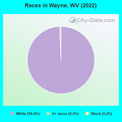
Races in Wayne detailed stats: ancestries, foreign born residents, place of birth
According to our research of West Virginia and other state lists, there were 21 registered sex offenders living in Wayne, West Virginia as of May 10, 2024.
The ratio of all residents to sex offenders in Wayne is 97 to 1.
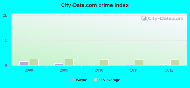
Type |
2009 |
2010 |
2011 |
2012 |
|---|---|---|---|---|
| Murders (per 100,000) | 0 (0.0) | 0 (0.0) | 0 (0.0) | 0 (0.0) |
| Rapes (per 100,000) | 0 (0.0) | 0 (0.0) | 0 (0.0) | 0 (0.0) |
| Robberies (per 100,000) | 0 (0.0) | 0 (0.0) | 0 (0.0) | 0 (0.0) |
| Assaults (per 100,000) | 0 (0.0) | 0 (0.0) | 0 (0.0) | 0 (0.0) |
| Burglaries (per 100,000) | 2 (179.1) | 2 (141.5) | 0 (0.0) | 2 (140.4) |
| Thefts (per 100,000) | 14 (1,253) | 2 (141.5) | 16 (1,131) | 8 (561.4) |
| Auto thefts (per 100,000) | 3 (268.6) | 0 (0.0) | 0 (0.0) | 0 (0.0) |
| Arson (per 100,000) | 0 (0.0) | 0 (0.0) | 0 (0.0) | 0 (0.0) |
| City-Data.com crime index | 84.2 | 15.6 | 45.2 | 32.3 |
The City-Data.com crime index weighs serious crimes and violent crimes more heavily. Higher means more crime, U.S. average is 246.1. It adjusts for the number of visitors and daily workers commuting into cities.
Crime rate in Wayne detailed stats: murders, rapes, robberies, assaults, burglaries, thefts, arson
Full-time law enforcement employees in 2021, including police officers: 2 (2 officers - 2 male; 0 female).
| Officers per 1,000 residents here: | 1.29 |
| West Virginia average: | 1.95 |
 Recent articles from our blog. Our writers, many of them Ph.D. graduates or candidates, create easy-to-read articles on a wide variety of topics.

 | Weather comparison - Huntington/Wayne vs Shepherdstown area? (3 replies) |
| Huntington Business News (2038 replies) |
| Where people go when they leave WV. (12 replies) |
| 2020 Census in West Virginia (24 replies) |
| WVU News, Facilities, and Information (645 replies) |
| Is Natural Gas bad for West Virginia? (209 replies) |
Latest news from Wayne, WV collected exclusively by city-data.com from local newspapers, TV, and radio stations
Ancestries: American (41.8%), English (33.6%), German (8.7%), European (7.9%), Irish (4.3%).
Current Local Time: EST time zone
Incorporated in 1882
Elevation: 708 feet
Land area: 0.65 square miles.
Population density: 2,159 people per square mile (low).
2 residents are foreign born
| This town: | 0.2% |
| West Virginia: | 1.1% |
| Wayne town: | 0.7% ($358) |
| West Virginia: | 0.6% ($378) |
Nearest city with pop. 50,000+: Huntington, WV  (12.8 miles , pop. 51,475).
Nearest city with pop. 200,000+: Fayette, KY (112.6 miles , pop. 260,512).
Nearest city with pop. 1,000,000+: Chicago, IL (373.2 miles , pop. 2,896,016).
Nearest cities:
), ), ), ), ), )Latitude: 38.23 N, Longitude: 82.44 W
Area code: 304
| Here: | 4.1% |
| West Virginia: | 4.0% |
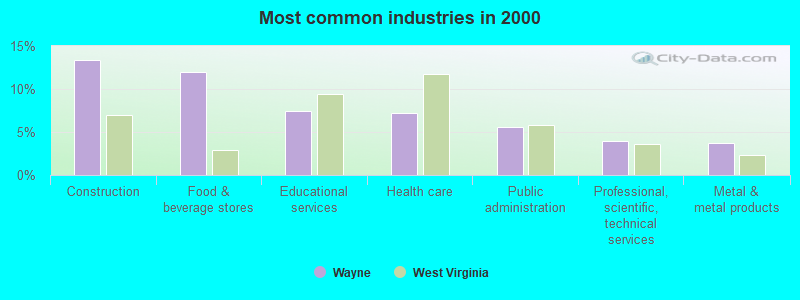
- Construction (13.4%)
- Food & beverage stores (12.0%)
- Educational services (7.5%)
- Health care (7.2%)
- Public administration (5.6%)
- Professional, scientific, technical services (4.0%)
- Metal & metal products (3.7%)
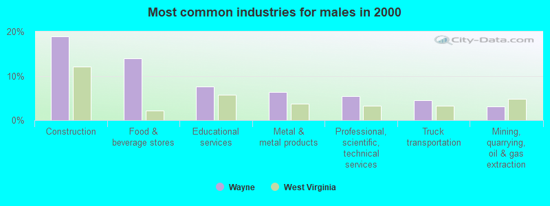
- Construction (18.9%)
- Food & beverage stores (14.0%)
- Educational services (7.7%)
- Metal & metal products (6.3%)
- Professional, scientific, technical services (5.4%)
- Truck transportation (4.5%)
- Mining, quarrying, oil & gas extraction (3.2%)
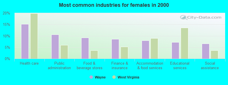
- Health care (15.1%)
- Public administration (10.5%)
- Food & beverage stores (9.2%)
- Finance & insurance (8.6%)
- Accommodation & food services (7.9%)
- Educational services (7.2%)
- Social assistance (6.6%)
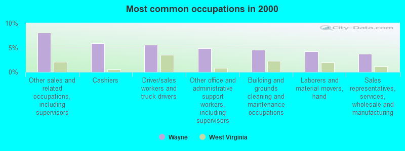
- Other sales and related occupations, including supervisors (8.0%)
- Cashiers (5.9%)
- Driver/sales workers and truck drivers (5.6%)
- Other office and administrative support workers, including supervisors (4.8%)
- Building and grounds cleaning and maintenance occupations (4.5%)
- Laborers and material movers, hand (4.3%)
- Sales representatives, services, wholesale and manufacturing (3.7%)
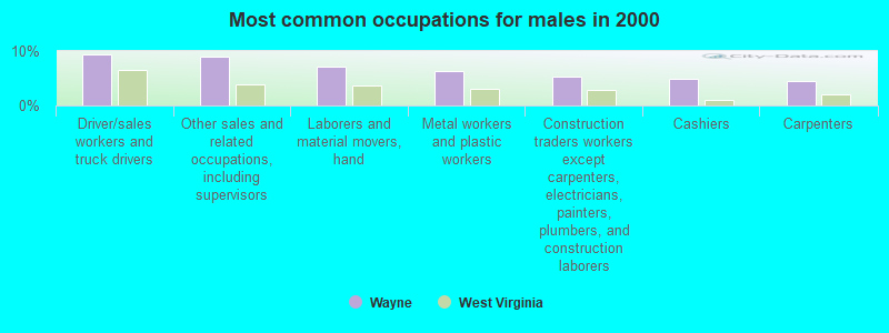
- Driver/sales workers and truck drivers (9.5%)
- Other sales and related occupations, including supervisors (9.0%)
- Laborers and material movers, hand (7.2%)
- Metal workers and plastic workers (6.3%)
- Construction traders workers except carpenters, electricians, painters, plumbers, and construction laborers (5.4%)
- Cashiers (5.0%)
- Carpenters (4.5%)
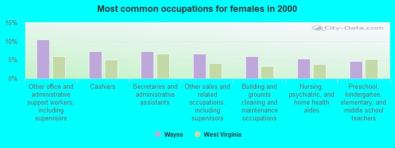
- Other office and administrative support workers, including supervisors (10.5%)
- Cashiers (7.2%)
- Secretaries and administrative assistants (7.2%)
- Other sales and related occupations, including supervisors (6.6%)
- Building and grounds cleaning and maintenance occupations (5.9%)
- Nursing, psychiatric, and home health aides (5.3%)
- Preschool, kindergarten, elementary, and middle school teachers (4.6%)
Average climate in Wayne, West Virginia
Based on data reported by over 4,000 weather stations


|
|


(lower is better)
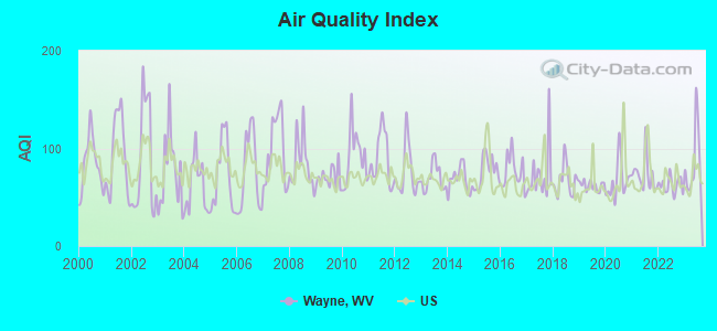
Air Quality Index (AQI) level in 2023 was 85.8. This is about average.
| City: | 85.8 |
| U.S.: | 72.6 |
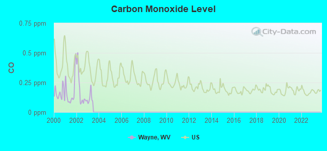
Carbon Monoxide (CO) [ppm] level in 2002 was 0.180. This is better than average. Closest monitor was 12.6 miles away from the city center.
| City: | 0.180 |
| U.S.: | 0.251 |
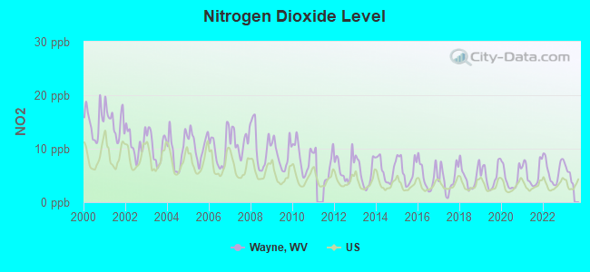
Nitrogen Dioxide (NO2) [ppb] level in 2022 was 5.87. This is about average. Closest monitor was 11.5 miles away from the city center.
| City: | 5.87 |
| U.S.: | 5.11 |
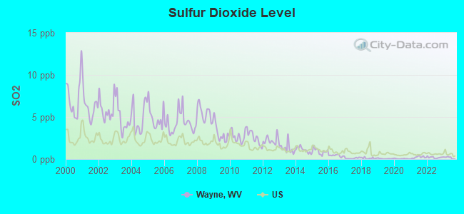
Sulfur Dioxide (SO2) [ppb] level in 2023 was 0.185. This is significantly better than average. Closest monitor was 10.8 miles away from the city center.
| City: | 0.185 |
| U.S.: | 1.515 |
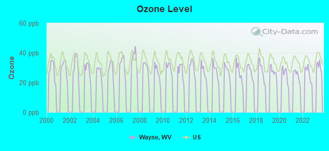
Ozone [ppb] level in 2022 was 26.3. This is better than average. Closest monitor was 12.6 miles away from the city center.
| City: | 26.3 |
| U.S.: | 33.3 |
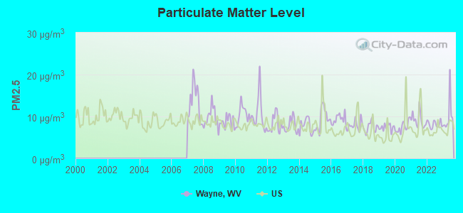
Particulate Matter (PM2.5) [µg/m3] level in 2023 was 10.1. This is worse than average. Closest monitor was 12.6 miles away from the city center.
| City: | 10.1 |
| U.S.: | 8.1 |
Tornado activity:
Wayne-area historical tornado activity is near West Virginia state average. It is 65% smaller than the overall U.S. average.
On 4/23/1968, a category F5 (max. wind speeds 261-318 mph) tornado 38.0 miles away from the Wayne town center killed 7 people and injured 93 people and caused between $500,000 and $5,000,000 in damages.
On 4/8/1965, a category F3 (max. wind speeds 158-206 mph) tornado 8.2 miles away from the town center injured 3 people and caused between $50,000 and $500,000 in damages.
Earthquake activity:
Wayne-area historical earthquake activity is significantly above West Virginia state average. It is 11% greater than the overall U.S. average.On 7/27/1980 at 18:52:21, a magnitude 5.2 (5.1 MB, 4.7 MS, 5.0 UK, 5.2 UK, Class: Moderate, Intensity: VI - VII) earthquake occurred 81.7 miles away from Wayne center
On 8/23/2011 at 17:51:04, a magnitude 5.8 (5.8 MW, Depth: 3.7 mi) earthquake occurred 246.2 miles away from the city center
On 8/9/2020 at 12:07:37, a magnitude 5.1 (5.1 MW, Depth: 4.7 mi) earthquake occurred 142.1 miles away from the city center
On 9/7/1988 at 02:28:09, a magnitude 4.6 (4.5 MB, 4.6 LG, Class: Light, Intensity: IV - V) earthquake occurred 78.4 miles away from the city center
On 9/25/1998 at 19:52:52, a magnitude 5.2 (4.8 MB, 4.3 MS, 5.2 LG, 4.5 MW, Depth: 3.1 mi) earthquake occurred 250.4 miles away from the city center
On 11/2/2006 at 17:53:02, a magnitude 4.3 (4.3 MB, Depth: 0.6 mi) earthquake occurred 76.6 miles away from Wayne center
Magnitude types: regional Lg-wave magnitude (LG), body-wave magnitude (MB), surface-wave magnitude (MS), moment magnitude (MW)
Natural disasters:
The number of natural disasters in Wayne County (27) is a lot greater than the US average (15).Major Disasters (Presidential) Declared: 21
Emergencies Declared: 4
Causes of natural disasters: Floods: 18, Storms: 17, Landslides: 10, Mudslides: 6, Winter Storms: 3, Hurricanes: 2, Blizzard: 1, Fire: 1, Snowfall: 1, Tornado: 1, Wind: 1, Other: 1 (Note: some incidents may be assigned to more than one category).

Hospitals and medical centers in Wayne:
- WAYNE COUNTY HOME HEALTH CARE AGENCY (P O BOX 368)
- WAYNE NURSING AND REHABILITATION CENTER, LLC (6999 ROUTE 152)
Other hospitals and medical centers near Wayne:
- HUNTINGTON VA MEDICAL CENTER (Hospital, Acute Care - Veterans Administration, about 12 miles away; HUNTINGTON, WV)
- THREE RIVERS HOME CARE (Home Health Center, about 13 miles away; LOUISA, KY)
- J ROBERT PRITCHARD DIALYSIS CENTER (Dialysis Facility, about 13 miles away; HUNTINGTON, WV)
- ST MARY'S MEDICAL CENTER Acute Care Hospitals (about 13 miles away; HUNTINGTON, WV)
- HUNTINGTON HEALTH AND REHABILITATION CENTER (Nursing Home, about 13 miles away; HUNTINGTON, WV)
- CABELL HUNTINGTON HOSPITAL HOME HEALTH (Home Health Center, about 13 miles away; HUNTINGTON, WV)
- CABELL-HUNTINGTON HOSPITAL INC Acute Care Hospitals (about 13 miles away; HUNTINGTON, WV)
Colleges/universities with over 2000 students nearest to Wayne:
- Marshall University (about 14 miles; Huntington, WV; Full-time enrollment: 11,450)
- Ashland Community and Technical College (about 21 miles; Ashland, KY; FT enrollment: 2,482)
- West Virginia State University (about 38 miles; Institute, WV; FT enrollment: 2,133)
- Big Sandy Community and Technical College (about 42 miles; Prestonsburg, KY; FT enrollment: 2,660)
- Shawnee State University (about 46 miles; Portsmouth, OH; FT enrollment: 4,160)
- Morehead State University (about 54 miles; Morehead, KY; FT enrollment: 7,523)
- New River Community and Technical College (about 73 miles; Beckley, WV; FT enrollment: 2,234)
Public high school in Wayne:
- WAYNE HIGH SCHOOL (Students: 670, Location: 100 PIONEER RD, Grades: 9-12)
Public elementary/middle school in Wayne:
- WAYNE MIDDLE SCHOOL (Students: 489, Location: 200 PIONEER ROAD, Grades: 6-8)
Points of interest:
Cemetery: Wayne Cemetery (1). Display/hide its location on the map
Court: Wayne Family Court (211 South Court).
Birthplace of: Larry McClure (baseball) - Baseball player.
Drinking water stations with addresses in Wayne and their reported violations in the past:
WAYNE WATER TOWN OF (Population served: 5,684, Surface water):Past health violations:
- MCL, Average - Between JUL-2009 and SEP-2009, Contaminant: TTHM. Follow-up actions: St Public Notif requested (OCT-23-2009), St Formal NOV issued (OCT-23-2009), St Compliance achieved (NOV-09-2009), St Public Notif received (NOV-09-2009), Fed Compliance achieved (DEC-15-2009)
- MCL, Average - Between APR-2009 and JUN-2009, Contaminant: TTHM. Follow-up actions: St Public Notif requested (JUL-21-2009), St Formal NOV issued (JUL-21-2009), St Public Notif received (AUG-14-2009), St Compliance achieved (NOV-09-2009), Fed Compliance achieved (DEC-15-2009)
- MCL, Average - Between JAN-2009 and MAR-2009, Contaminant: TTHM. Follow-up actions: St Public Notif requested (APR-22-2009), St Formal NOV issued (APR-22-2009), St Public Notif received (MAY-01-2009), St Compliance achieved (NOV-09-2009), Fed Compliance achieved (DEC-15-2009)
- MCL, Average - Between OCT-2008 and DEC-2008, Contaminant: TTHM. Follow-up actions: St Public Notif requested (APR-22-2009), St Formal NOV issued (APR-22-2009), St Public Notif received (MAY-01-2009), St Compliance achieved (NOV-09-2009), Fed Compliance achieved (DEC-15-2009)
| This town: | 2.2 people |
| West Virginia: | 2.4 people |
| This town: | 58.9% |
| Whole state: | 65.8% |
| This town: | 6.6% |
| Whole state: | 6.6% |
Likely homosexual households (counted as self-reported same-sex unmarried-partner households)
- Lesbian couples: 0.6% of all households
- Gay men: 0.3% of all households
Banks with branches in Wayne (2011 data):
- JPMorgan Chase Bank, National Association: Wayne Main at 608 Hendricks Street, branch established on 1902/12/08. Info updated 2011/11/10: Bank assets: $1,811,678.0 mil, Deposits: $1,190,738.0 mil, headquarters in Columbus, OH, positive income, International Specialization, 5577 total offices, Holding Company: Jpmorgan Chase & Co.
- City National Bank of West Virginia: Wayne Branch at 206 Central Avenue, branch established on 1995/11/11. Info updated 2008/01/10: Bank assets: $2,753.2 mil, Deposits: $2,223.1 mil, headquarters in Charleston, WV, positive income, Commercial Lending Specialization, 68 total offices, Holding Company: City Holding Company
For population 15 years and over in Wayne:

- Never married: 17.6%
- Now married: 58.4%
- Separated: 3.7%
- Widowed: 5.2%
- Divorced: 15.2%
For population 25 years and over in Wayne:
- High school or higher: 74.5%
- Bachelor's degree or higher: 9.5%
- Graduate or professional degree: 2.2%
- Unemployed: 8.6%
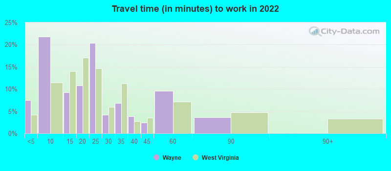
- Mean travel time to work (commute): 36.2 minutes

| Here: | 7.7 |
| West Virginia average: | 11.1 |

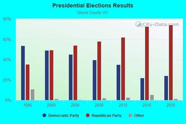
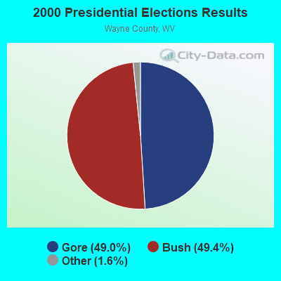
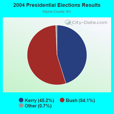
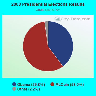
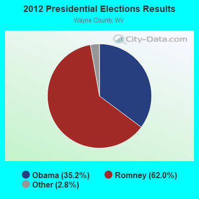
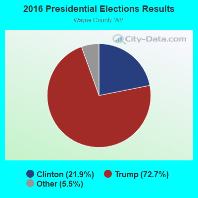
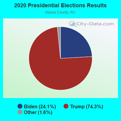
Graphs represent county-level data. Detailed 2008 Election Results
Religion statistics for Wayne, WV (based on Wayne County data)
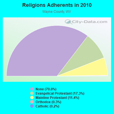
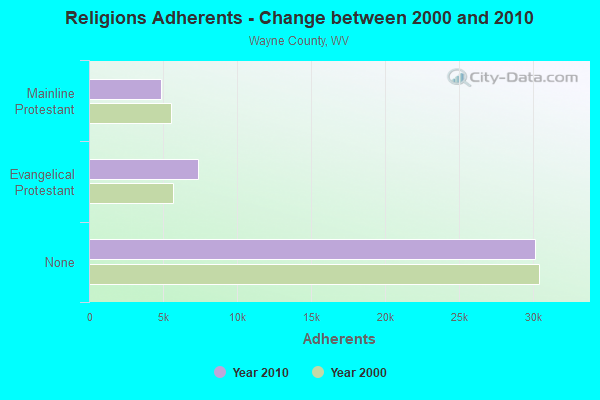
| Religion | Adherents | Congregations |
|---|---|---|
| Evangelical Protestant | 7,338 | 55 |
| Mainline Protestant | 4,840 | 27 |
| Orthodox | 115 | 3 |
| Catholic | 89 | 1 |
| Other | 2 | - |
| None | 30,097 | - |
Food Environment Statistics:
| This county: | 2.18 / 10,000 pop. |
| State: | 2.41 / 10,000 pop. |
| Wayne County: | 0.24 / 10,000 pop. |
| State: | 0.28 / 10,000 pop. |
| Wayne County: | 0.24 / 10,000 pop. |
| West Virginia: | 1.09 / 10,000 pop. |
| Wayne County: | 6.07 / 10,000 pop. |
| West Virginia: | 5.38 / 10,000 pop. |
| Wayne County: | 3.88 / 10,000 pop. |
| West Virginia: | 6.22 / 10,000 pop. |
| This county: | 11.7% |
| State: | 12.2% |
| This county: | 35.7% |
| State: | 31.1% |
| Wayne County: | 12.1% |
| West Virginia: | 13.1% |
Health and Nutrition:
| Wayne: | 47.3% |
| West Virginia: | 51.8% |
| Wayne: | 42.4% |
| West Virginia: | 49.7% |
| Wayne: | 28.9 |
| West Virginia: | 28.6 |
| Here: | 16.9% |
| State: | 20.4% |
| This city: | 21.8% |
| West Virginia: | 9.7% |
| Wayne: | 6.9 |
| West Virginia: | 6.9 |
| Here: | 33.8% |
| State: | 34.8% |
| This city: | 51.1% |
| West Virginia: | 58.4% |
| Here: | 83.1% |
| West Virginia: | 78.6% |
More about Health and Nutrition of Wayne, WV Residents
| Local government employment and payroll (March 2022) | |||||
| Function | Full-time employees | Monthly full-time payroll | Average yearly full-time wage | Part-time employees | Monthly part-time payroll |
|---|---|---|---|---|---|
| Water Supply | 11 | $33,702 | $36,766 | 1 | $2,133 |
| Police Protection - Officers | 2 | $5,269 | $31,614 | 4 | $9,142 |
| Other Government Administration | 2 | $9,675 | $58,050 | 10 | $5,269 |
| Sewerage | 2 | $6,328 | $37,968 | 0 | $0 |
| Police - Other | 2 | $5,469 | $32,814 | 1 | $1,003 |
| Solid Waste Management | 1 | $2,176 | $26,112 | 3 | $6,346 |
| Other and Unallocable | 0 | $0 | 1 | $555 | |
| Totals for Government | 20 | $62,619 | $37,571 | 20 | $24,448 |
Wayne government finances - Expenditure in 2021 (per resident):
- Current Operations - Water Utilities: $857,000 ($609.96)
Financial Administration: $243,000 ($172.95)
Sewerage: $230,000 ($163.70)
Solid Waste Management: $145,000 ($103.20)
Regular Highways: $131,000 ($93.24)
Police Protection: $131,000 ($93.24)
Parks and Recreation: $31,000 ($22.06)
Local Fire Protection: $10,000 ($7.12)
- General - Interest on Debt: $40,000 ($28.47)
- Water Utilities - Interest on Debt: $48,000 ($34.16)
Wayne government finances - Revenue in 2021 (per resident):
- Charges - Sewerage: $316,000 ($224.91)
Other: $129,000 ($91.81)
Parks and Recreation: $8,000 ($5.69)
- Miscellaneous - Fines and Forfeits: $18,000 ($12.81)
General Revenue - Other: $18,000 ($12.81)
Interest Earnings: $5,000 ($3.56)
- Revenue - Water Utilities: $1,018,000 ($724.56)
- State Intergovernmental - General Local Government Support: $9,000 ($6.41)
Other: $5,000 ($3.56)
- Tax - General Sales and Gross Receipts: $373,000 ($265.48)
Property: $161,000 ($114.59)
Public Utilities Sales: $100,000 ($71.17)
Other License: $4,000 ($2.85)
Wayne government finances - Debt in 2021 (per resident):
- Long Term Debt - Beginning Outstanding - Unspecified Public Purpose: $4,039,000 ($2874.73)
Outstanding Unspecified Public Purpose: $3,913,000 ($2785.05)
Retired Unspecified Public Purpose: $126,000 ($89.68)
Wayne government finances - Cash and Securities in 2021 (per resident):
- Other Funds - Cash and Securities: $384,000 ($273.31)
| Businesses in Wayne, WV | ||||
| Name | Count | Name | Count | |
|---|---|---|---|---|
| H&R Block | 1 | Rite Aid | 1 | |
| KFC | 1 | Subway | 1 | |
| Lane Furniture | 1 | Walmart | 1 | |
| MasterBrand Cabinets | 2 | Wendy's | 1 | |
| Nike | 1 | |||
Strongest AM radio stations in Wayne:
- WVHU (800 AM; 5 kW; HUNTINGTON, WV; Owner: CAPSTAR TX LIMITED PARTNERSHIP)
- WRVC (930 AM; 5 kW; HUNTINGTON, WV; Owner: FIFTH AVENUE BROADCASTING COMPANY, INC.)
- WHRD (1470 AM; 5 kW; HUNTINGTON, WV; Owner: CONCORD MEDIA GROUP, INC.)
- WTCR (1420 AM; 5 kW; KENOVA, WV; Owner: CAPSTAR TX LIMITED PARTNERSHIP)
- WTVN (610 AM; 50 kW; COLUMBUS, OH; Owner: CITICASTERS LICENSES, L.P.)
- WOKT (1040 AM; daytime; 2 kW; CANNONSBURG, KY; Owner: BIG RIVER RADIO, INC.-KY)
- WZZW (1600 AM; 5 kW; MILTON, WV; Owner: CAPSTAR TX LIMITED PARTNERSHIP)
- WKYH (600 AM; 5 kW; PAINTSVILLE, KY; Owner: HIGHLANDS BROADCASTING CORPORATION)
- WCAW (680 AM; 10 kW; CHARLESTON, WV; Owner: WEST VIRGINIA RADIO CORPORATION OF CHARLESTON)
- WCHS (580 AM; 5 kW; CHARLESTON, WV; Owner: WEST VIRGINIA RADIO CORPORATION OF CHARLESTON)
- WBGS (1030 AM; daytime; 10 kW; POINT PLEASANT, WV; Owner: BIG RIVER RADIO, INC.)
- WGOH (1370 AM; 5 kW; GRAYSON, KY; Owner: CARTER COUNTY BROADCASTING CO., INC.)
- WLW (700 AM; 50 kW; CINCINNATI, OH; Owner: JACOR BROADCASTING CORPORATION)
Strongest FM radio stations in Wayne:
- WKEE-FM (100.5 FM; HUNTINGTON, WV; Owner: CAPSTAR TX LIMITED PARTNERSHIP)
- WVWV (89.9 FM; HUNTINGTON, WV; Owner: WEST VIRGINIA EDUCATIONAL BROADCASTING AUTHORITY)
- WDGG (93.7 FM; ASHLAND, KY; Owner: FIFTH AVENUE B/CASTING COMPANY, INC.)
- WKLC-FM (105.1 FM; ST. ALBANS, WV; Owner: WKLC, INC.)
- WAMX (106.3 FM; MILTON, WV; Owner: CAPSTAR TX LIMITED PARTNERSHIP)
- WZAQ (92.3 FM; LOUISA, KY; Owner: LOUISA COMMUNICATIONS, INC.)
- WTCR-FM (103.3 FM; HUNTINGTON, WV; Owner: CAPSTAR TX LIMITED PARTNERSHIP)
- WRVC-FM (92.7 FM; CATLETTSBURG, KY; Owner: FIFTH AVENUE BROADCASTING CO., INC)
- WBKS (107.1 FM; IRONTON, OH; Owner: CAPSTAR TX LIMITED PARTNERSHIP)
- WEMM (107.9 FM; HUNTINGTON, WV; Owner: MORTENSON BROADCASTING CO. OF WEST VIRGINIA, LLC)
- WPAY-FM (104.1 FM; PORTSMOUTH, OH; Owner: RADIO STATIONS WPAY/WPFB, INC.)
- WFGH (90.7 FM; FORT GAY, WV; Owner: WAYNE COUNTY BOARD OF EDUCATION)
- WBVB (97.1 FM; COAL GROVE, OH; Owner: CAPSTAR TX LIMITED PARTNERSHIP)
- WMEJ (91.9 FM; PROCTORVILLE, OH; Owner: MARANATHA BROADCASTING INC.)
- WQHY (95.5 FM; PRESTONSBURG, KY; Owner: WDOC, INC.)
- WVOW-FM (101.9 FM; LOGAN, WV; Owner: LOGAN BROADCASTING CORP.)
- WKLW-FM (94.7 FM; PAINTSVILLE, KY; Owner: B & G BROADCASTING, INC.)
- WRYV-FM1 (101.5 FM; HUNTINGTON, WV; Owner: LEGEND COMMUNICATIONS OF OHIO, LLC)
- WOUL-FM (89.1 FM; IRONTON, OH; Owner: OHIO UNIVERSITY)
- WZAC-FM (92.5 FM; DANVILLE, WV; Owner: PRICE BROADCASTING COMPANY)
TV broadcast stations around Wayne:
- WPBY-TV (Channel 33; HUNTINGTON, WV; Owner: WEST VIRGINIA EDUCATIONAL BROADCASTING AUTHORITY)
- WSAZ-TV (Channel 3; HUNTINGTON, WV; Owner: EMMIS TELEVISION LICENSE CORPORATION)
- WVAH-TV (Channel 11; CHARLESTON, WV; Owner: WVAH LICENSEE, LLC)
- WOWK-TV (Channel 13; HUNTINGTON, WV; Owner: WEST VIRGINIA MEDIA HOLDINGS, LLC)
- W14CU (Channel 14; HUNTINGTON, WV; Owner: VENTANA TELEVISION, INC.)
- WCHS-TV (Channel 8; CHARLESTON, WV; Owner: WCHS LICENSEE, LLC)
- WTSF (Channel 61; ASHLAND, KY; Owner: TRI STATE FAMILY BROADCASTING, INC.)
- W49BN (Channel 49; HUNTINGTON, WV; Owner: PAXSON COMMUNCATIONS LPTV, INC.)
- W36CR (Channel 36; HUNTINGTON, WV; Owner: NATIONAL MINORITY T.V., INC.)
- WKAS (Channel 25; ASHLAND, KY; Owner: KENTUCKY AUTHORITY FOR EDUCATIONAL TV)
- WLPX-TV (Channel 29; CHARLESTON, WV; Owner: PAXSON CHARLESTON LICENSE, INC.)
- W55AT (Channel 55; HUNTINGTON, WV; Owner: CHANNEL AMERICA LPTV LIC. SUBSIDIARY)
- W05CB (Channel 5; BURLINGTON, OH; Owner: VEARL R. PENNINGTON)
- Wayne, West Virginia
- Fatal accident count20
- Vehicles involved in fatal accidents24
- Fatal accidents involving drunk persons:7
- Fatalities22
- Persons involved in fatal accidents30
- Pedestrians involved in fatal accidents1
- West Virginia average
- Fatal accident count4747
- Vehicles involved in fatal accidents6975
- Fatal accidents involving drunk persons1628
- Fatalities5227
- Persons involved in fatal accidents11023
- Pedestrians involved in fatal accidents389
- National Bridge Inventory (NBI) Statistics
- 26Number of bridges
- 246ft / 75.3mTotal length
- $5,221,000Total costs
- 61,610Total average daily traffic
- 3,483Total average daily truck traffic
- 101,033Total future (year 2036) average daily traffic
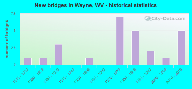
- New bridges - historical statistics
- 11910-1919
- 11920-1929
- 31930-1939
- 11950-1959
- 71970-1979
- 51980-1989
- 21990-1999
- 12000-2009
- 52010-2019
FCC Registered Antenna Towers: 47 (See the full list of FCC Registered Antenna Towers)
FCC Registered Broadcast Land Mobile Towers: 8 (See the full list of FCC Registered Broadcast Land Mobile Towers in Wayne, WV)
FCC Registered Microwave Towers: 8 (See the full list of FCC Registered Microwave Towers in this town)
FCC Registered Paging Towers: 1 (See the full list of FCC Registered Paging Towers)
FCC Registered Amateur Radio Licenses: 42 (See the full list of FCC Registered Amateur Radio Licenses in Wayne)
2003 - 2018 National Fire Incident Reporting System (NFIRS) incidents
- Fire incident types reported to NFIRS in Wayne, WV
- 29557.2%Structure Fires
- 12123.4%Outside Fires
- 8516.5%Mobile Property/Vehicle Fires
- 152.9%Other
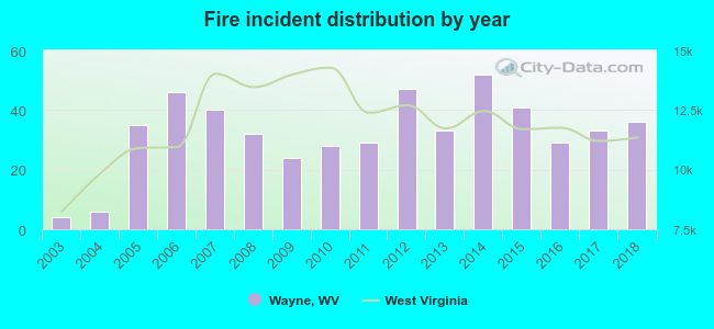 Based on the data from the years 2003 - 2018 the average number of fire incidents per year is 32. The highest number of reported fire incidents - 52 took place in 2014, and the least - 4 in 2003. The data has a rising trend.
 When looking into fire subcategories, the most reports belonged to: Structure Fires (57.2%), and Outside Fires (23.4%).
| Most common first names in Wayne, WV among deceased individuals | ||
| Name | Count | Lived (average) |
|---|---|---|
| John | 38 | 75.4 years |
| James | 36 | 69.1 years |
| William | 35 | 68.8 years |
| Mary | 33 | 79.0 years |
| Charles | 22 | 71.0 years |
| Frank | 16 | 78.3 years |
| George | 15 | 74.7 years |
| Robert | 14 | 66.6 years |
| Henry | 12 | 81.8 years |
| Paul | 12 | 67.7 years |
| Most common last names in Wayne, WV among deceased individuals | ||
| Last name | Count | Lived (average) |
|---|---|---|
| Adkins | 119 | 73.6 years |
| Smith | 46 | 71.3 years |
| Napier | 38 | 76.4 years |
| Maynard | 36 | 70.7 years |
| Watts | 33 | 75.2 years |
| Thompson | 31 | 71.8 years |
| Ferguson | 30 | 73.3 years |
| Mills | 28 | 78.1 years |
| Blankenship | 27 | 74.0 years |
| Ross | 27 | 74.1 years |
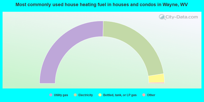
- 50.9%Utility gas
- 44.6%Electricity
- 4.5%Bottled, tank, or LP gas
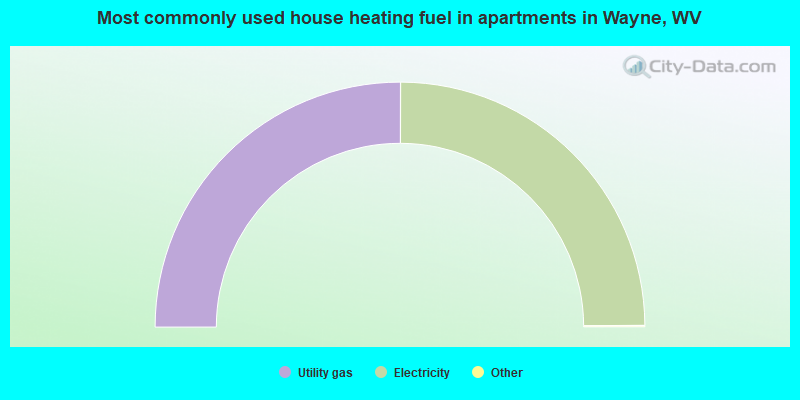
- 50.2%Utility gas
- 49.8%Electricity
Wayne compared to West Virginia state average:
- Median household income below state average.
- Median house value below state average.
- Unemployed percentage below state average.
- Black race population percentage significantly below state average.
- Hispanic race population percentage significantly below state average.
- Foreign-born population percentage significantly below state average.
- Renting percentage above state average.
- Length of stay since moving in significantly above state average.
- Percentage of population with a bachelor's degree or higher below state average.

|
Total of 3 patent applications in 2008-2024.