Fort Gay, West Virginia

Submit your own pictures of this town and show them to the world

Percentage of residents living in poverty in 2022: 37.9%
(35.9% for White Non-Hispanic residents, 37.5% for Hispanic or Latino residents, 100.0% for two or more races residents)

Full-time law enforcement employees in 2021, including police officers: 3 (3 officers - 3 male; 0 female).
Officers per 1,000 residents here:

4.43
West Virginia average:

1.95
Recent articles from our blog. Our writers, many of them Ph.D. graduates or candidates, create easy-to-read articles on a wide variety of topics.
Unemployment in December 2023:
Here:

4.1%
West Virginia:

4.0%
Most common industries in Fort Gay, WV (%)
Both Males Females
Most common industries in 2000
  • Health care (13.1%)
  • Construction (10.3%)
  • Food & beverage stores (8.9%)
  • Administrative & support & waste management services (7.5%)
  • Rail transportation (7.5%)
  • Accommodation & food services (7.0%)
  • Social assistance (3.8%)
Most common industries for males in 2000
  • Construction (20.4%)
  • Rail transportation (14.8%)
  • Truck transportation (6.5%)
  • Health care (6.5%)
  • Chemicals (5.6%)
  • Administrative & support & waste management services (5.6%)
  • Repair & maintenance (5.6%)
Most common industries for females in 2000
  • Health care (20.0%)
  • Food & beverage stores (14.3%)
  • Accommodation & food services (14.3%)
  • Administrative & support & waste management services (9.5%)
  • Educational services (7.6%)
  • Social assistance (7.6%)
  • Gasoline stations (6.7%)
Most common occupations in Fort Gay, WV (%)
Both Males Females
Most common occupations in 2000
  • Cooks and food preparation workers (8.0%)
  • Cashiers (7.0%)
  • Building and grounds cleaning and maintenance occupations (6.1%)
  • Electrical equipment mechanics and other installation, maintenance, and repair workers, including supervisors (5.6%)
  • Other sales and related occupations, including supervisors (4.2%)
  • Metal workers and plastic workers (3.8%)
  • Child care workers (3.8%)
Most common occupations for males in 2000
  • Electrical equipment mechanics and other installation, maintenance, and repair workers, including supervisors (11.1%)
  • Metal workers and plastic workers (7.4%)
  • Construction laborers (6.5%)
  • Driver/sales workers and truck drivers (6.5%)
  • Other sales and related occupations, including supervisors (5.6%)
  • Vehicle and mobile equipment mechanics, installers, and repairers (5.6%)
  • Laborers and material movers, hand (5.6%)
Most common occupations for females in 2000
  • Cooks and food preparation workers (16.2%)
  • Cashiers (14.3%)
  • Building and grounds cleaning and maintenance occupations (8.6%)
  • Child care workers (7.6%)
  • Other management occupations, except farmers and farm managers (6.7%)
  • Secretaries and administrative assistants (5.7%)
  • Preschool, kindergarten, elementary, and middle school teachers (4.8%)

Average climate in Fort Gay, West Virginia

Based on data reported by over 4,000 weather stations

Fort Gay, West Virginia average temperatures Fort Gay, West Virginia average precipitation Fort Gay, West Virginia humidity Fort Gay, West Virginia wind speed Fort Gay, West Virginia snowfall Fort Gay, West Virginia sunshine Fort Gay, West Virginia clear and cloudy days
Air pollution and air quality trends
(lower is better)
AQI CO NO2 SO2 Ozone PM2.5
Air Quality Index

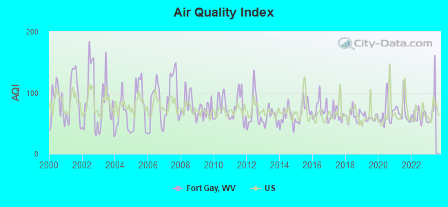
Air Quality Index (AQI) level in 2022 was 61.0. This is about average.

City:

61.0
U.S.:

72.6
Carbon Monoxide Level

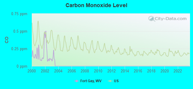
Carbon Monoxide (CO) [ppm] level in 2002 was 0.180. This is better than average. Closest monitor was 17.6 miles away from the city center.

City:

0.180
U.S.:

0.251
Nitrogen Dioxide Level

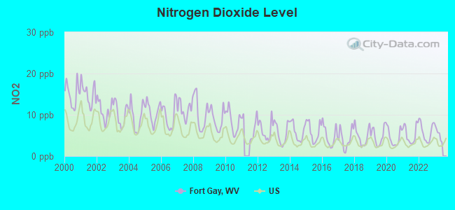
Nitrogen Dioxide (NO2) [ppb] level in 2022 was 5.87. This is about average. Closest monitor was 0.2 miles away from the city center.

City:

5.87
U.S.:

5.11
Sulfur Dioxide Level

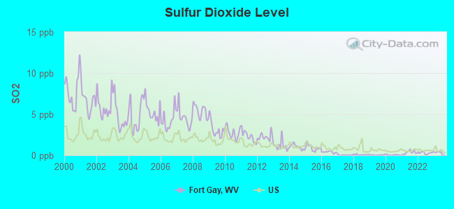
Sulfur Dioxide (SO2) [ppb] level in 2022 was 0.306. This is significantly better than average. Closest monitor was 0.2 miles away from the city center.

City:

0.306
U.S.:

1.515
Ozone Level

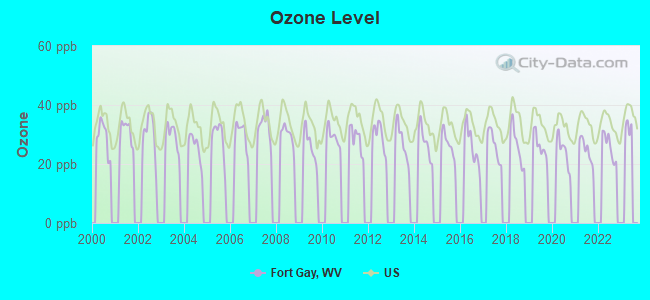
Ozone [ppb] level in 2022 was 26.0. This is better than average. Closest monitor was 15.8 miles away from the city center.

City:

26.0
U.S.:

33.3
Particulate Matter Level

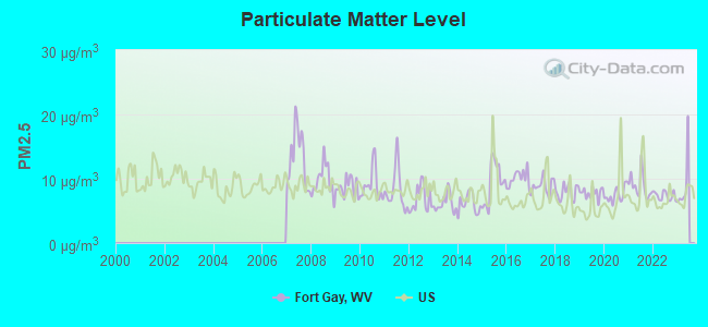
Particulate Matter (PM2.5) [µg/m3] level in 2022 was 7.36. This is about average. Closest monitor was 22.1 miles away from the city center.

City:

7.36
U.S.:

8.11

Tornado activity:

Fort Gay-area historical tornado activity is near West Virginia state average. It is 64% smaller than the overall U.S. average.

On 4/23/1968, a category F5 (max. wind speeds 261-318 mph) tornado 41.8 miles away from the Fort Gay town center killed 7 people and injured 93 people and caused between $500,000 and $5,000,000 in damages.

On 4/8/1965, a category F3 (max. wind speeds 158-206 mph) tornado 15.2 miles away from the town center injured 3 people and caused between $50,000 and $500,000 in damages.

Earthquake activity:

Fort Gay-area historical earthquake activity is significantly above West Virginia state average. It is 16% greater than the overall U.S. average.

On 7/27/1980 at 18:52:21, a magnitude 5.2 (5.1 MB, 4.7 MS, 5.0 UK, 5.2 UK, Class: Moderate, Intensity: VI - VII) earthquake occurred 73.6 miles away from Fort Gay center
On 8/23/2011 at 17:51:04, a magnitude 5.8 (5.8 MW, Depth: 3.7 mi) earthquake occurred 254.2 miles away from Fort Gay center
On 8/9/2020 at 12:07:37, a magnitude 5.1 (5.1 MW, Depth: 4.7 mi) earthquake occurred 140.4 miles away from Fort Gay center
On 9/7/1988 at 02:28:09, a magnitude 4.6 (4.5 MB, 4.6 LG, Class: Light, Intensity: IV - V) earthquake occurred 69.8 miles away from Fort Gay center
On 4/18/2008 at 09:36:59, a magnitude 5.4 (5.1 MB, 4.8 MS, 5.4 MW, 5.2 MW) earthquake occurred 288.2 miles away from the city center
On 11/2/2006 at 17:53:02, a magnitude 4.3 (4.3 MB, Depth: 0.6 mi) earthquake occurred 73.4 miles away from Fort Gay center
Magnitude types: regional Lg-wave magnitude (LG), body-wave magnitude (MB), surface-wave magnitude (MS), moment magnitude (MW)

Natural disasters:

The number of natural disasters in Wayne County (27) is a lot greater than the US average (15).
Major Disasters (Presidential) Declared: 21
Emergencies Declared: 4

Causes of natural disasters: Floods: 18, Storms: 17, Landslides: 10, Mudslides: 6, Winter Storms: 3, Hurricanes: 2, Blizzard: 1, Fire: 1, Snowfall: 1, Tornado: 1, Wind: 1, Other: 1 (Note: some incidents may be assigned to more than one category).
Fort Gay topographic map

Hospitals and medical centers in Fort Gay:

  • THREE RIVERS HOME CARE (PO BOX 117)

Other hospitals and medical centers near Fort Gay:

  • THREE RIVERS HOME CARE (Home Health Center, about 1 miles away; LOUISA, KY)
  • WAYNE NURSING AND REHABILITATION CENTER, LLC (Nursing Home, about 12 miles away; WAYNE, WV)

Colleges/universities with over 2000 students nearest to Fort Gay:

  • Marshall University (about 23 miles; Huntington, WV; Full-time enrollment: 11,450)
  • Ashland Community and Technical College (about 25 miles; Ashland, KY; FT enrollment: 2,482)
  • Big Sandy Community and Technical College (about 32 miles; Prestonsburg, KY; FT enrollment: 2,660)
  • Morehead State University (about 46 miles; Morehead, KY; FT enrollment: 7,523)
  • Shawnee State University (about 48 miles; Portsmouth, OH; FT enrollment: 4,160)
  • West Virginia State University (about 49 miles; Institute, WV; FT enrollment: 2,133)
  • Hazard Community and Technical College (about 69 miles; Hazard, KY; FT enrollment: 2,087)

Public high school in Fort Gay:

Public elementary/middle school in Fort Gay:

  • FORT GAY PRE K-8 (Location: 1 VIKING DRIVE, Grades: PK-8)
See full list of schools located in Fort Gay

User-submitted facts and corrections:

  • Mayor- Regina Hill added by jcr

Points of interest:

Click to draw/clear town borders

Notable location: Fort Gay Volunteer Fire Department (A). Display/hide its location on the map

Cemetery: Fairview Cemetery (1). Display/hide its location on the map

Streams, rivers, and creeks: Tug Fork (A), Mill Creek (B), Lick Branch (C). Display/hide their locations on the map

Wayne County has a predicted average indoor radon screening level between 2 and 4 pCi/L (pico curies per liter) - Moderate Potential

Drinking water stations with addresses in Fort Gay and their reported violations in the past:

FORT GAY WATER WORKS (Population served: 2,287, Surface water):
Past monitoring violations:
  • Monitoring and Reporting (DBP) - Between APR-2011 and JUN-2011, Contaminant: CARBON, TOTAL. Follow-up actions: St Compliance achieved (AUG-17-2011)
  • Monitoring and Reporting (DBP) - Between APR-2010 and JUN-2010, Contaminant: CARBON, TOTAL. Follow-up actions: St Compliance achieved (JUL-07-2010), St Public Notif requested (JUL-28-2010), St Formal NOV issued (JUL-28-2010)
  • Monitoring and Reporting (DBP) - Between OCT-2009 and DEC-2009, Contaminant: Total Haloacetic Acids (HAA5). Follow-up actions: St Public Notif requested (JAN-30-2010), St Formal NOV issued (JAN-30-2010), St Compliance achieved (FEB-11-2010)
  • Monitoring and Reporting (DBP) - Between OCT-2009 and DEC-2009, Contaminant: TTHM. Follow-up actions: St Public Notif requested (JAN-30-2010), St Formal NOV issued (JAN-30-2010), St Compliance achieved (FEB-11-2010)
  • Monitoring, Turbidity (Enhanced SWTR) - In AUG-2009, Contaminant: IESWTR. Follow-up actions: St Compliance achieved (SEP-15-2009), St Public Notif requested (NOV-06-2009), St Formal NOV issued (NOV-06-2009), St Public Notif received (MAR-31-2010)
  • 2 routine major monitoring violations
  • One minor monitoring violation
  • 4 other older monitoring violations
Average household size:
This town:

2.2 people
West Virginia:

2.4 people

Percentage of family households:
This town:

61.0%
Whole state:

65.8%

Percentage of households with unmarried partners:
This town:

3.7%
Whole state:

6.6%


No gay or lesbian households reported

Banks with branches in Fort Gay (2011 data):

  • Community Trust Bank, Inc.: Hamlin Fort Gay Branch at 3200 Court Street, branch established on 1982/12/28. Info updated 2011/03/25: Bank assets: $3,573.0 mil, Deposits: $2,890.4 mil, headquarters in Pikeville, KY, positive income, Commercial Lending Specialization, 80 total offices, Holding Company: Community Trust Bancorp, Inc.
Educational Attainment in 2022
School Enrollment by Level of School in 2022
Education Gini index (Inequality in education)
Here:

8.3
West Virginia average:

11.1

Presidential Elections Results

Graphs represent county-level data. Detailed 2008 Election Results

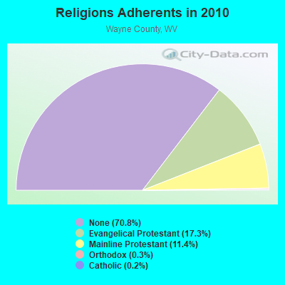
Religion statistics for Fort Gay, WV (based on Wayne County data)

Religions Adherents in 2010
Religions Adherents - Change between 2000 and 2010
ReligionAdherentsCongregations
Evangelical Protestant7,33855
Mainline Protestant4,84027
Orthodox1153
Catholic891
Other2-
None30,097-
Source: Clifford Grammich, Kirk Hadaway, Richard Houseal, Dale E.Jones, Alexei Krindatch, Richie Stanley and Richard H.Taylor. 2012. 2010 U.S.Religion Census: Religious Congregations & Membership Study. Association of Statisticians of American Religious Bodies. Jones, Dale E., et al. 2002. Congregations and Membership in the United States 2000. Nashville, TN: Glenmary Research Center. Graphs represent county-level data

Food Environment Statistics:

Number of grocery stores: 9
Wayne County:

2.18 / 10,000 pop.
West Virginia:

2.41 / 10,000 pop.
Number of supercenters and club stores: 1
Wayne County:

0.24 / 10,000 pop.
West Virginia:

0.28 / 10,000 pop.
Number of convenience stores (no gas): 1
Here:

0.24 / 10,000 pop.
West Virginia:

1.09 / 10,000 pop.
Number of convenience stores (with gas): 25
Here:

6.07 / 10,000 pop.
State:

5.38 / 10,000 pop.
Number of full-service restaurants: 16
Wayne County:

3.88 / 10,000 pop.
West Virginia:

6.22 / 10,000 pop.
Adult diabetes rate:
This county:

11.7%
West Virginia:

12.2%
Adult obesity rate:
This county:

35.7%
West Virginia:

31.1%
Low-income preschool obesity rate:
Wayne County:

12.1%
West Virginia:

13.1%

Health and Nutrition:

Healthy diet rate:
Fort Gay:

50.2%
West Virginia:

51.8%

Average overall health of teeth and gums:
Fort Gay:

48.1%
State:

49.7%

Average BMI:
Fort Gay:

28.9
West Virginia:

28.6

People feeling badly about themselves:
Here:

19.6%
West Virginia:

20.4%

People not drinking alcohol at all:
Here:

9.5%
State:

9.7%

Average hours sleeping at night:
Fort Gay:

6.9
West Virginia:

6.9

Overweight people:
This city:

34.9%
West Virginia:

34.8%

General health condition:
Fort Gay:

58.0%
West Virginia:

58.4%

Average condition of hearing:
Here:

78.6%
West Virginia:

78.6%

More about Health and Nutrition of Fort Gay, WV Residents
Local government employment and payroll (March 2022)
Function Full-time employees Monthly full-time payroll Average yearly full-time wage Part-time employees Monthly part-time payroll
Water Supply 6$11,432$22,8640$0
Police Protection - Officers 2$5,081$30,4860$0
Other Government Administration 2$3,817$22,9020$0
Financial Administration 1$2,078$24,9360$0
Judicial and Legal 0$0 1$1,386
Sewerage 0$0 3$3,378
Totals for Government 11$22,408$24,4454$4,764

Fort Gay government finances - Expenditure in 2017 (per resident):

  • Current Operations - Sewerage: $180,000 ($271.08)
    Police Protection: $94,000 ($141.57)
    Central Staff Services: $27,000 ($40.66)
    Financial Administration: $24,000 ($36.14)
    General - Other: $14,000 ($21.08)
    Regular Highways: $8,000 ($12.05)
    Protective Inspection and Regulation - Other: $7,000 ($10.54)
    Parks and Recreation: $5,000 ($7.53)
    Judicial and Legal Services: $2,000 ($3.01)
    Miscellaneous Commercial Activities - Other: $2,000 ($3.01)
    Local Fire Protection: $1,000 ($1.51)
  • General - Interest on Debt: $25,000 ($37.65)
  • Other Capital Outlay - General Public Building: $47,000 ($70.78)
    Police Protection: $3,000 ($4.52)
    Solid Waste Management: $3,000 ($4.52)
  • Total Salaries and Wages: $112,000 ($168.67)

Fort Gay government finances - Revenue in 2017 (per resident):

  • Charges - Sewerage: $227,000 ($341.87)
    Miscellaneous Commercial Activities: $6,000 ($9.04)
    Other: $3,000 ($4.52)
  • Miscellaneous - General Revenue - Other: $45,000 ($67.77)
    Fines and Forfeits: $11,000 ($16.57)
  • State Intergovernmental - General Local Government Support: $3,000 ($4.52)
  • Tax - Property: $92,000 ($138.55)
    Occupation and Business License - Other: $76,000 ($114.46)
    Public Utilities Sales: $29,000 ($43.67)
    Other License: $7,000 ($10.54)
    Alcoholic Beverage Sales: $2,000 ($3.01)

Fort Gay government finances - Debt in 2017 (per resident):

  • Long Term Debt - Beginning Outstanding - Unspecified Public Purpose: $1,117,000 ($1682.23)
    Outstanding Unspecified Public Purpose: $1,055,000 ($1588.86)
    Retired Unspecified Public Purpose: $62,000 ($93.37)

Fort Gay government finances - Cash and Securities in 2017 (per resident):

  • Other Funds - Cash and Securities: $271,000 ($408.13)
  • Sinking Funds - Cash and Securities: $86,000 ($129.52)

Businesses in Fort Gay, WV

  • Lane Furniture: 1

Strongest AM radio stations in Fort Gay:

  • WVHU (800 AM; 5 kW; HUNTINGTON, WV; Owner: CAPSTAR TX LIMITED PARTNERSHIP)
  • WRVC (930 AM; 5 kW; HUNTINGTON, WV; Owner: FIFTH AVENUE BROADCASTING COMPANY, INC.)
  • WKYH (600 AM; 5 kW; PAINTSVILLE, KY; Owner: HIGHLANDS BROADCASTING CORPORATION)
  • WTCR (1420 AM; 5 kW; KENOVA, WV; Owner: CAPSTAR TX LIMITED PARTNERSHIP)
  • WHRD (1470 AM; 5 kW; HUNTINGTON, WV; Owner: CONCORD MEDIA GROUP, INC.)
  • WTVN (610 AM; 50 kW; COLUMBUS, OH; Owner: CITICASTERS LICENSES, L.P.)
  • WOKT (1040 AM; daytime; 2 kW; CANNONSBURG, KY; Owner: BIG RIVER RADIO, INC.-KY)
  • WGOH (1370 AM; 5 kW; GRAYSON, KY; Owner: CARTER COUNTY BROADCASTING CO., INC.)
  • WPRT (960 AM; 5 kW; PRESTONSBURG, KY; Owner: EAST KENTUCKY RADIO NETWORK, INC.)
  • WLW (700 AM; 50 kW; CINCINNATI, OH; Owner: JACOR BROADCASTING CORPORATION)
  • WCAW (680 AM; 10 kW; CHARLESTON, WV; Owner: WEST VIRGINIA RADIO CORPORATION OF CHARLESTON)
  • WDOC (1310 AM; 5 kW; PRESTONSBURG, KY)
  • WCHS (580 AM; 5 kW; CHARLESTON, WV; Owner: WEST VIRGINIA RADIO CORPORATION OF CHARLESTON)

Strongest FM radio stations in Fort Gay:

  • WFGH (90.7 FM; FORT GAY, WV; Owner: WAYNE COUNTY BOARD OF EDUCATION)
  • WZAQ (92.3 FM; LOUISA, KY; Owner: LOUISA COMMUNICATIONS, INC.)
  • WDGG (93.7 FM; ASHLAND, KY; Owner: FIFTH AVENUE B/CASTING COMPANY, INC.)
  • WKLC-FM (105.1 FM; ST. ALBANS, WV; Owner: WKLC, INC.)
  • WVWV (89.9 FM; HUNTINGTON, WV; Owner: WEST VIRGINIA EDUCATIONAL BROADCASTING AUTHORITY)
  • WQHY (95.5 FM; PRESTONSBURG, KY; Owner: WDOC, INC.)
  • WKEE-FM (100.5 FM; HUNTINGTON, WV; Owner: CAPSTAR TX LIMITED PARTNERSHIP)
  • WAMX (106.3 FM; MILTON, WV; Owner: CAPSTAR TX LIMITED PARTNERSHIP)
  • WKLW-FM (94.7 FM; PAINTSVILLE, KY; Owner: B & G BROADCASTING, INC.)
  • WPAY-FM (104.1 FM; PORTSMOUTH, OH; Owner: RADIO STATIONS WPAY/WPFB, INC.)
  • WBKS (107.1 FM; IRONTON, OH; Owner: CAPSTAR TX LIMITED PARTNERSHIP)
  • WSIP-FM (98.9 FM; PAINTSVILLE, KY; Owner: SIP BROADCASTING, INC.)
  • WRVC-FM (92.7 FM; CATLETTSBURG, KY; Owner: FIFTH AVENUE BROADCASTING CO., INC)
  • WTCR-FM (103.3 FM; HUNTINGTON, WV; Owner: CAPSTAR TX LIMITED PARTNERSHIP)
  • WXLR (104.9 FM; HAROLD, KY; Owner: ADAM D GEARHEART)
  • WVOW-FM (101.9 FM; LOGAN, WV; Owner: LOGAN BROADCASTING CORP.)
  • WBVB (97.1 FM; COAL GROVE, OH; Owner: CAPSTAR TX LIMITED PARTNERSHIP)
  • WVKM (106.7 FM; MATEWAN, WV; Owner: THREE STATES BROADCASTING CO., INC.)
  • WEMM (107.9 FM; HUNTINGTON, WV; Owner: MORTENSON BROADCASTING CO. OF WEST VIRGINIA, LLC)
  • WUGO (102.3 FM; GRAYSON, KY; Owner: CARTER COUNTY BROADCASTING CO., INC.)

TV broadcast stations around Fort Gay:

  • W10AR (Channel 10; LOUISA, KY; Owner: KENTUCKY AUTHORITY FOR EDUCATIONAL TV)
  • WVAH-TV (Channel 11; CHARLESTON, WV; Owner: WVAH LICENSEE, LLC)
  • WPBY-TV (Channel 33; HUNTINGTON, WV; Owner: WEST VIRGINIA EDUCATIONAL BROADCASTING AUTHORITY)
  • WSAZ-TV (Channel 3; HUNTINGTON, WV; Owner: EMMIS TELEVISION LICENSE CORPORATION)
  • WCHS-TV (Channel 8; CHARLESTON, WV; Owner: WCHS LICENSEE, LLC)
  • WOWK-TV (Channel 13; HUNTINGTON, WV; Owner: WEST VIRGINIA MEDIA HOLDINGS, LLC)
  • W14CU (Channel 14; HUNTINGTON, WV; Owner: VENTANA TELEVISION, INC.)
  • WTSF (Channel 61; ASHLAND, KY; Owner: TRI STATE FAMILY BROADCASTING, INC.)
  • WKAS (Channel 25; ASHLAND, KY; Owner: KENTUCKY AUTHORITY FOR EDUCATIONAL TV)
  • W49BN (Channel 49; HUNTINGTON, WV; Owner: PAXSON COMMUNCATIONS LPTV, INC.)
  • Fort Gay, West Virginia
  • Fatal accident count18
  • Vehicles involved in fatal accidents22
  • Fatal accidents involving drunk persons:3
  • Fatalities23
  • Persons involved in fatal accidents47
  • Pedestrians involved in fatal accidents1
  • West Virginia average
  • Fatal accident count3939
  • Vehicles involved in fatal accidents5752
  • Fatal accidents involving drunk persons1300
  • Fatalities4357
  • Persons involved in fatal accidents9165
  • Pedestrians involved in fatal accidents343
See more detailed statistics of Fort Gay fatal car crashes and road traffic accidents for 1975 - 2021 here
  • National Bridge Inventory (NBI) Statistics
  • 10Number of bridges
  • 217ft / 66.3mTotal length
  • $885,000Total costs
  • 26,886Total average daily traffic
  • 4,101Total average daily truck traffic
  • 42,538Total future (year 2032) average daily traffic
New bridges in Fort Gay, WV - historical statistics
  • New bridges - historical statistics
  • 41970-1979
  • 21980-1989
  • 42010-2019
See full National Bridge Inventory statistics for Fort Gay, WV

FCC Registered Cell Phone Towers:

1 (See the full list of FCC Registered Cell Phone Towers in Fort Gay)

FCC Registered Antenna Towers:

15 (See the full list of FCC Registered Antenna Towers)

FCC Registered Microwave Towers:

1
  • FORT GAY, 7642 A Cass Street (Lat: 38.130333 Lon: -82.597528), Type: Ltower, Structure height: 91.7 m, Overall height: 93 m, Call Sign: WQSC318,
    Assigned Frequencies: 6197.24 MHz, Grant Date: 07/25/2023, Expiration Date: 08/29/2033, Certifier: John E Monday, Registrant: At&t Services, Inc., 208 S Akard St, 20f, Dallas, TX 75202, Phone: (855) 699-7073, Email:


FCC Registered Paging Towers:

1
  • Ailiff Heights (Lat: 38.132861 Lon: -82.593472), Call Sign: KWT851,
    Assigned Frequencies: 152.240 MHz, Grant Date: 04/19/1999, Expiration Date: 04/01/2009, Cancellation Date: 09/08/2008, Certifier: Norbert H Snobeck, Registrant: Unity Communications,Inc., 7945 Macarthur Blvd, Suite 214, Cabin John, MD 20818, Phone: (301) 760-4622, Fax: (301) 229-7730, Email:


FCC Registered Amateur Radio Licenses:

34 (See the full list of FCC Registered Amateur Radio Licenses in Fort Gay)

FAA Registered Aircraft:

1
  • Aircraft: BUCKEY AVIATION INC SKY HAWK (Category: Land, Seats: 2, Weight: Up to 12,499 Pounds), Engine: ROTAX 582SER (65 HP) (2 Cycle)
    N-Number: 9455M, N9455M, N-9455M, Serial Number: 6103, Year manufactured: 2001, Airworthiness Date: 08/22/2008, Certificate Issue Date: 04/26/2019
    Registrant (Individual): Grant Maynard, 325 Saltpetre Rd, Fort Gay, WV 25514

Home Mortgage Disclosure Act Aggregated Statistics For Year 2007
(Based on 1 partial tract)
C) Refinancings
NumberAverage Value
LOANS ORIGINATED0$0
APPLICATIONS APPROVED, NOT ACCEPTED0$0
APPLICATIONS DENIED1$50,480
APPLICATIONS WITHDRAWN0$0
FILES CLOSED FOR INCOMPLETENESS0$0
Choose year:  2007 2006 2005 2004 2003 2002 2001 2000 1999

Detailed HMDA statistics for the following Tracts: 0208.00

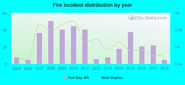
2005 - 2018 National Fire Incident Reporting System (NFIRS) incidents

    Fire incident distribution by year Based on the data from the years 2005 - 2018 the average number of fire incidents per year is 25. The highest number of reported fires - 51 took place in 2008, and the least - 5 in 2006. The data has a dropping trend.
    Fire incident types in Fort Gay, WV 
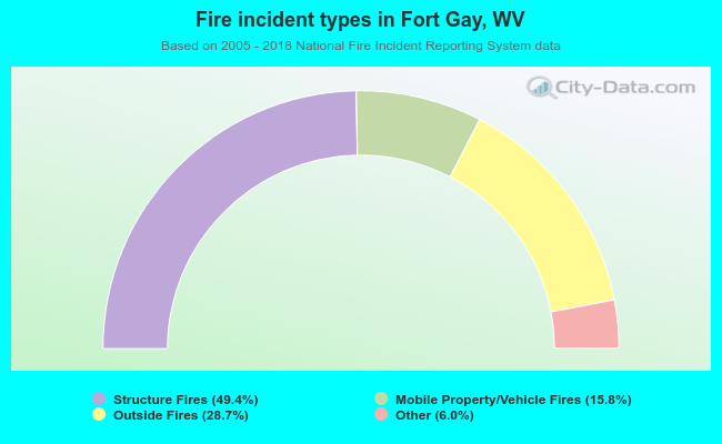
When looking into fire subcategories, the most reports belonged to: Structure Fires (49.4%), and Outside Fires (28.7%).

    • Fire incident types reported to NFIRS in Fort Gay, WV
    • 17249.4%Structure Fires
    • 10028.7%Outside Fires
    • 5515.8%Mobile Property/Vehicle Fires
    • 216.0%Other
See full National Fire Incident Reporting System statistics for Fort Gay, WV
Most common first names in Fort Gay, WV among deceased individuals
NameCountLived (average)
James2468.9 years
William2172.6 years
Mary2082.2 years
Charles1571.8 years
John1571.7 years
Fred1380.9 years
George1178.0 years
Frank1072.1 years
Pearl975.4 years
Ernest969.2 years
Most common last names in Fort Gay, WV among deceased individuals
Last nameCountLived (average)
Thompson5774.3 years
Wellman4179.1 years
Robertson2669.8 years
Maynard2173.5 years
Ferguson1778.7 years
Crabtree1681.0 years
Johnson1569.3 years
Adkins1472.9 years
Copley1469.4 years
Smith1276.4 years
Houses and condos Apartments
Most commonly used house heating fuel in houses and condos in Fort Gay, WV
  • 53.9%Electricity
  • 46.1%Utility gas
Most commonly used house heating fuel in apartments in Fort Gay, WV
  • 51.1%Electricity
  • 48.9%Utility gas


Fort Gay compared to West Virginia state average:

  • Median household income significantly below state average.
  • Median house value significantly below state average.
  • Black race population percentage significantly below state average.
  • Foreign-born population percentage significantly below state average.
  • Renting percentage above state average.
  • Length of stay since moving in significantly above state average.
  • Number of college students below state average.
  • Percentage of population with a bachelor's degree or higher significantly below state average.
There are 4 pilots and no other airmen in this city.
Cost of Living Calculator