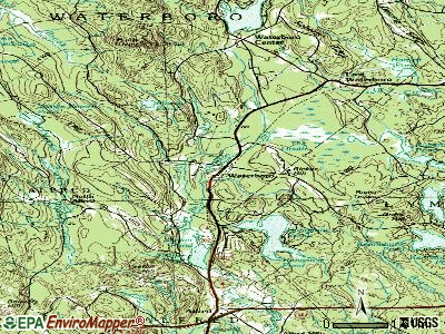
Waterboro, Maine
Submit your own pictures of this town and show them to the world
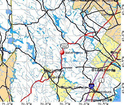
- OSM Map
- General Map
- Google Map
- MSN Map
Population change since 2000: +23.8%
| Males: 3,907 | |
| Females: 3,786 |
| Median resident age: | 36.6 years |
| Maine median age: | 43.0 years |
Zip codes: 04061.
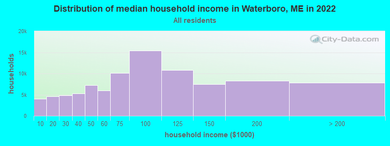
| Waterboro: | $81,184 |
| ME: | $69,543 |
Estimated per capita income in 2022: $36,239 (it was $17,813 in 2000)
Waterboro town income, earnings, and wages data
Estimated median house or condo value in 2022: $310,471 (it was $97,200 in 2000)
| Waterboro: | $310,471 |
| ME: | $290,600 |
Mean prices in 2022: all housing units: $451,552; detached houses: $470,451; townhouses or other attached units: $577,335; in 2-unit structures: $383,179; in 3-to-4-unit structures: $310,696; in 5-or-more-unit structures: $252,113; mobile homes: $105,501
Detailed information about poverty and poor residents in Waterboro, ME

Compare current foreclosures near Waterboro, ME:
| Photo | Address | Area | Beds / Baths | Price | Details |
|---|---|---|---|---|---|

|
#1
Cram Rd
East Baldwin, ME 04024
|
982 sq. feet
|
1 baths 2 beds |
show details | |

|
#2
Great East Ln
Sanbornville, NH 03872
|
1,963 sq. feet
|
2 baths 3 beds |
show details | |

|
#3
Nason St # B
Sanford, ME 04073
|
1,320 sq. feet
|
1 baths 3 beds |
show details | |

|
#4
Line Rd
Gorham, ME 04038
|
1,086 sq. feet
|
1 baths 3 beds |
show details | |

|
#5
Goldie Ln
Standish, ME 04084
|
2,273 sq. feet
|
1 baths 3 beds |
show details | |

|
#6
Dollys Way
Scarborough, ME 04074
|
1,821 sq. feet
|
2 baths 3 beds |
show details | |

|
#7
Scammon St
Saco, ME 04072
|
1,340 sq. feet
|
2 baths 4 beds |
show details | |

|
#8
Jennifer Way
Gorham, ME 04038
|
1,414 sq. feet
|
1 baths 3 beds |
show details | |

|
#9
Main St
Gorham, ME 04038
|
691 sq. feet
|
1 baths 2 beds |
show details | |

|
#10
Fletcher St
Kennebunk, ME 04043
|
1,638 sq. feet
|
1 baths 3 beds |
show details |
| Photo | Address | Area | Beds / Baths | Price | Details |
|---|---|---|---|---|---|

|
#11
Rose Terrace Cir
Kennebunkport, ME 04046
|
- sq. feet
|
- baths - beds |
show details | |

|
#12
Lincoln Rd
Saco, ME 04072
|
- sq. feet
|
- baths - beds |
show details | |

|
#13
West St Apt 5
Biddeford, ME 04005
|
- sq. feet
|
- baths - beds |
show details | |

|
#14
Main St Apt 2
Biddeford, ME 04005
|
- sq. feet
|
- baths - beds |
show details | |

|
#15
Stagecoach Dr
Old Orchard Beach, ME 04064
|
- sq. feet
|
- baths - beds |
show details | |

|
#16
Stoneham Rd
Sanbornville, NH 03872
|
- sq. feet
|
- baths - beds |
show details | |

|
#17
Graham St
Biddeford, ME 04005
|
- sq. feet
|
- baths - beds |
show details | |

|
#18
Forest St
Saco, ME 04072
|
- sq. feet
|
- baths - beds |
show details | |

|
#19
Chick Rd
Lebanon, ME 04027
|
- sq. feet
|
- baths - beds |
show details | |

|
#20
White Mountain Hwy
Milton, NH 03851
|
- sq. feet
|
- baths - beds |
show details |
| Photo | Address | Area | Beds / Baths | Price | Details |
|---|---|---|---|---|---|

|
#21
Ross Corner Rd
Shapleigh, ME 04076
|
- sq. feet
|
- baths - beds |
show details | |

|
#22
Main St
Springvale, ME 04083
|
- sq. feet
|
- baths - beds |
show details | |

|
#23
Emma Ln
Gorham, ME 04038
|
- sq. feet
|
- baths - beds |
show details | |

|
#24
Webster Rd
Buxton, ME 04093
|
- sq. feet
|
- baths - beds |
show details | |

|
#25
Jackson St # B
Sanford, ME 04073
|
- sq. feet
|
- baths - beds |
show details | |

|
#26
Main St Apt 404
Sanford, ME 04073
|
- sq. feet
|
- baths - beds |
show details | |

|
#27
Basswood St
Alfred, ME 04002
|
- sq. feet
|
- baths - beds |
show details | |

|
#28
Biddeford Rd
Alfred, ME 04002
|
- sq. feet
|
- baths - beds |
show details | |

|
#29
Cape Rd
Limington, ME 04049
|
- sq. feet
|
- baths - beds |
show details | |

|
#30
Harlan Dr
Limington, ME 04049
|
- sq. feet
|
- baths - beds |
show details |
| Photo | Address | Area | Beds / Baths | Price | Details |
|---|---|---|---|---|---|

|
#31
Sokokis Ave
Limington, ME 04049
|
- sq. feet
|
- baths - beds |
show details | |

|
#32
Harvard St
Sanford, ME 04073
|
- sq. feet
|
- baths - beds |
show details | |

|
#33
Narragansett Trl
Buxton, ME 04093
|
- sq. feet
|
- baths - beds |
show details | |

|
#34
Pond Rd
Sanbornville, NH 03872
|
- sq. feet
|
- baths - beds |
show details | |

|
#35
Little River Rd
Lebanon, ME 04027
|
- sq. feet
|
- baths - beds |
show details | |

|
#36
Heath Rd
Sanbornville, NH 03872
|
- sq. feet
|
- baths - beds |
show details | |

|
#37
Curtis Rd
Kennebunkport, ME 04046
|
- sq. feet
|
- baths - beds |
show details | |

|
#38
New Dam Rd
North Waterboro, ME 04061
|
- sq. feet
|
- baths - beds |
show details | |

|
Check over 1 million property listings on Foreclosure.com!
|
browse all offers | |||

- 7,44696.8%White alone
- 811.1%Two or more races
- 660.9%Hispanic
- 500.6%Asian alone
- 310.4%Black alone
- 140.2%American Indian alone
- 40.05%Other race alone
- 10.01%Native Hawaiian and Other
Pacific Islander alone
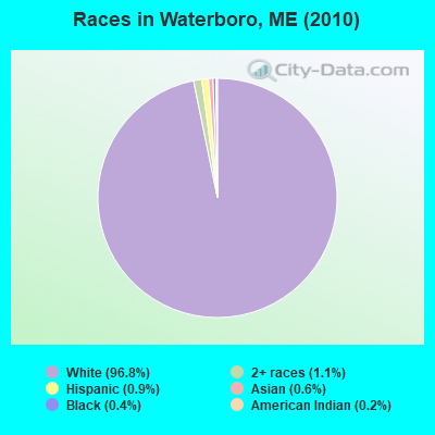
Races in Waterboro detailed stats: ancestries, foreign born residents, place of birth
According to our research of Maine and other state lists, there were 9 registered sex offenders living in Waterboro, Maine as of May 04, 2024.
The ratio of all residents to sex offenders in Waterboro is 855 to 1.
The ratio of registered sex offenders to all residents in this city is lower than the state average.
 Recent articles from our blog. Our writers, many of them Ph.D. graduates or candidates, create easy-to-read articles on a wide variety of topics.

 | Waterboro, ME what's life like?? (5 replies) |
| Moving from Southern California to Coastal Maine soon. (16 replies) |
| BEST Maine town to grow old in (356 replies) |
| safest town in york county (5 replies) |
| Wells drying up? (22 replies) |
| The best place to live in Maine. (394 replies) |
Latest news from Waterboro, ME collected exclusively by city-data.com from local newspapers, TV, and radio stations
Waterboro, ME City Guides:
Ancestries: English (19.0%), French (17.8%), Irish (14.8%), United States (11.8%), French Canadian (10.3%), Scottish (5.3%).
Current Local Time: EST time zone
Incorporated on 03/03/1787
Elevation: 268 feet
Land area: 55.5 square miles.
Population density: 139 people per square mile (very low).
90 residents are foreign born
| This town: | 1.4% |
| Maine: | 2.9% |
| Waterboro town: | 1.2% ($1,141) |
| Maine: | 1.5% ($1,417) |
Nearest city with pop. 50,000+: Portland, ME  (22.8 miles , pop. 64,249).
Nearest city with pop. 200,000+: Boston, MA (90.7 miles , pop. 589,141).
Nearest city with pop. 1,000,000+: Bronx, NY (250.0 miles , pop. 1,332,650).
Nearest cities:
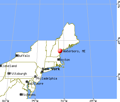
), ), ), ), )Latitude: 43.60 N, Longitude: 70.72 W
Area code: 207

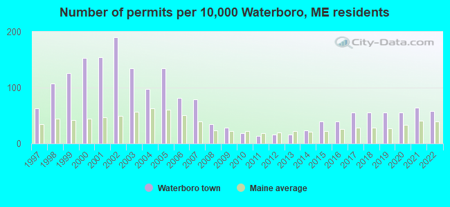
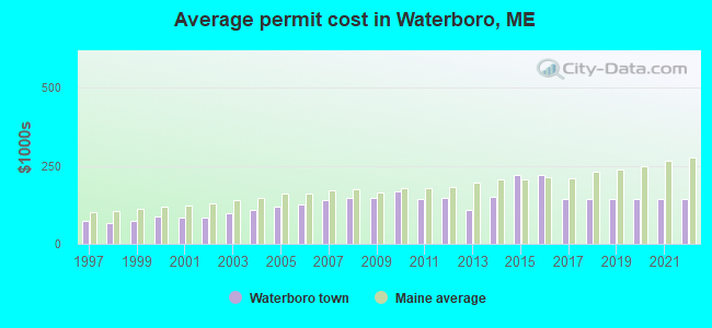
Single-family new house construction building permits:
- 2022: 36 buildings, average cost: $145,400
- 2021: 40 buildings, average cost: $145,400
- 2020: 35 buildings, average cost: $145,400
- 2019: 34 buildings, average cost: $145,400
- 2018: 35 buildings, average cost: $145,400
- 2017: 34 buildings, average cost: $145,400
- 2016: 25 buildings, average cost: $221,400
- 2015: 25 buildings, average cost: $221,400
- 2014: 15 buildings, average cost: $151,000
- 2013: 10 buildings, average cost: $110,000
- 2012: 10 buildings, average cost: $147,100
- 2011: 8 buildings, average cost: $144,200
- 2010: 12 buildings, average cost: $169,600
- 2009: 18 buildings, average cost: $147,100
- 2008: 22 buildings, average cost: $146,600
- 2007: 49 buildings, average cost: $139,500
- 2006: 51 buildings, average cost: $127,200
- 2005: 84 buildings, average cost: $119,800
- 2004: 60 buildings, average cost: $110,300
- 2003: 84 buildings, average cost: $97,400
- 2002: 118 buildings, average cost: $83,900
- 2001: 96 buildings, average cost: $83,400
- 2000: 95 buildings, average cost: $86,000
- 1999: 78 buildings, average cost: $74,800
- 1998: 67 buildings, average cost: $65,800
- 1997: 39 buildings, average cost: $75,200
| Here: | 3.0% |
| Maine: | 3.4% |
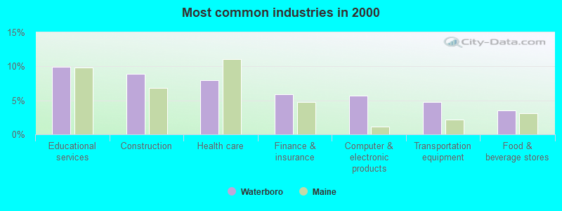
- Educational services (9.9%)
- Construction (8.9%)
- Health care (8.0%)
- Finance & insurance (5.9%)
- Computer & electronic products (5.7%)
- Transportation equipment (4.7%)
- Food & beverage stores (3.6%)
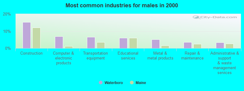
- Construction (15.2%)
- Computer & electronic products (6.9%)
- Transportation equipment (6.6%)
- Educational services (6.0%)
- Metal & metal products (5.1%)
- Repair & maintenance (3.5%)
- Administrative & support & waste management services (3.4%)
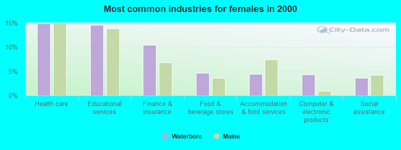
- Health care (14.9%)
- Educational services (14.6%)
- Finance & insurance (10.5%)
- Food & beverage stores (4.7%)
- Accommodation & food services (4.5%)
- Computer & electronic products (4.3%)
- Social assistance (3.6%)
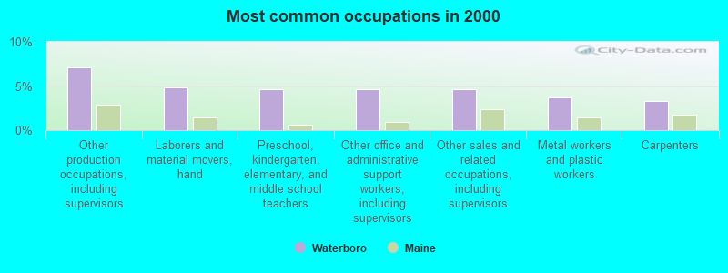
- Other production occupations, including supervisors (7.1%)
- Laborers and material movers, hand (4.9%)
- Preschool, kindergarten, elementary, and middle school teachers (4.7%)
- Other office and administrative support workers, including supervisors (4.7%)
- Other sales and related occupations, including supervisors (4.6%)
- Metal workers and plastic workers (3.7%)
- Carpenters (3.4%)
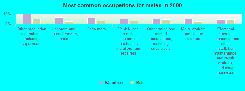
- Other production occupations, including supervisors (9.9%)
- Laborers and material movers, hand (6.6%)
- Carpenters (6.1%)
- Vehicle and mobile equipment mechanics, installers, and repairers (5.5%)
- Other sales and related occupations, including supervisors (5.2%)
- Metal workers and plastic workers (4.9%)
- Electrical equipment mechanics and other installation, maintenance, and repair workers, including supervisors (4.5%)

- Other office and administrative support workers, including supervisors (9.2%)
- Preschool, kindergarten, elementary, and middle school teachers (7.6%)
- Cashiers (4.4%)
- Information and record clerks, except customer service representatives (4.2%)
- Retail sales workers, except cashiers (4.2%)
- Nursing, psychiatric, and home health aides (3.9%)
- Other sales and related occupations, including supervisors (3.9%)
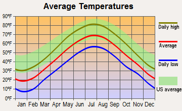
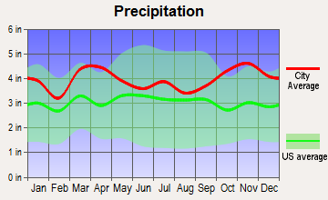
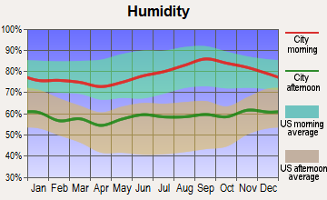
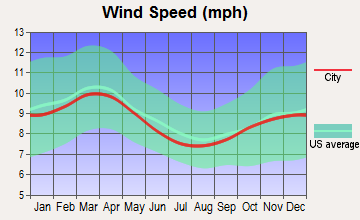
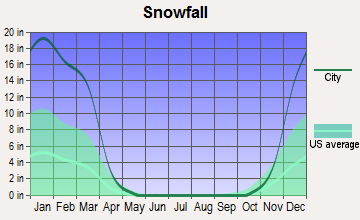
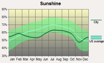
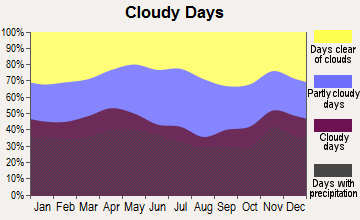
Average climate in Waterboro, Maine
Based on data reported by over 4,000 weather stations
(lower is better)
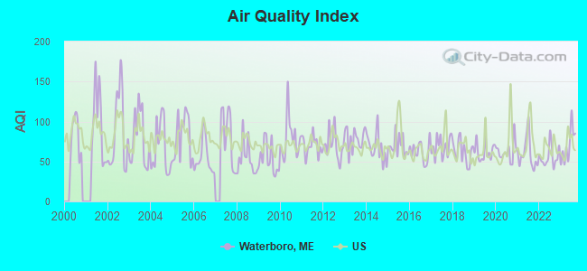
Air Quality Index (AQI) level in 2023 was 70.1. This is about average.
| City: | 70.1 |
| U.S.: | 72.6 |
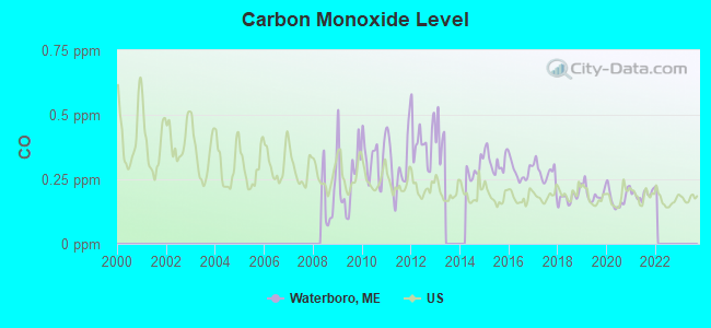
Carbon Monoxide (CO) [ppm] level in 2021 was 0.192. This is better than average. Closest monitor was 22.7 miles away from the city center.
| City: | 0.192 |
| U.S.: | 0.251 |
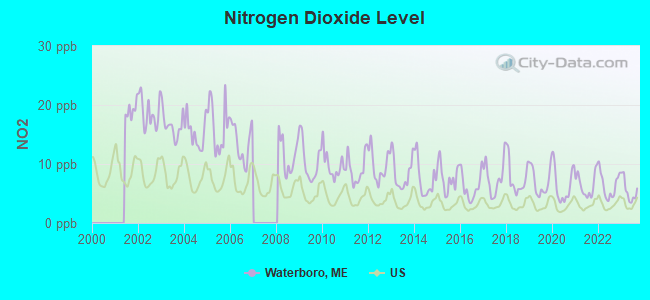
Nitrogen Dioxide (NO2) [ppb] level in 2023 was 5.47. This is about average. Closest monitor was 21.9 miles away from the city center.
| City: | 5.47 |
| U.S.: | 5.11 |
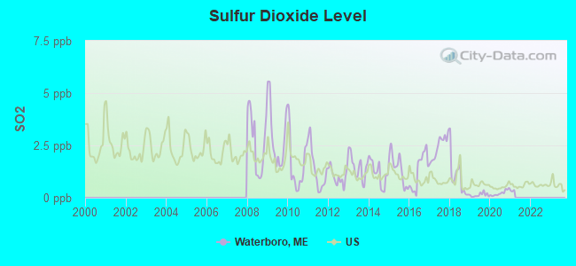
Sulfur Dioxide (SO2) [ppb] level in 2020 was 0.222. This is significantly better than average. Closest monitor was 10.7 miles away from the city center.
| City: | 0.222 |
| U.S.: | 1.515 |
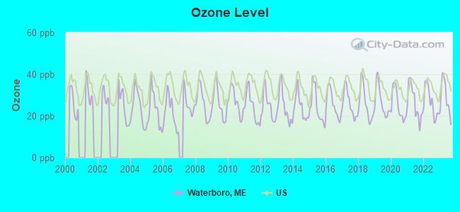
Ozone [ppb] level in 2023 was 28.7. This is about average. Closest monitor was 5.1 miles away from the city center.
| City: | 28.7 |
| U.S.: | 33.3 |
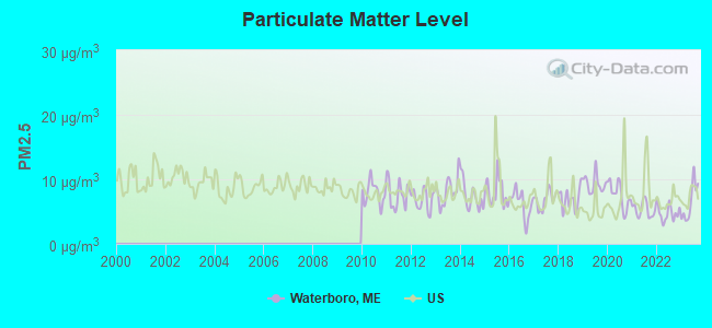
Particulate Matter (PM2.5) [µg/m3] level in 2023 was 6.47. This is better than average. Closest monitor was 15.7 miles away from the city center.
| City: | 6.47 |
| U.S.: | 8.11 |
Tornado activity:
Waterboro-area historical tornado activity is significantly above Maine state average. It is 70% smaller than the overall U.S. average.
On 10/10/1966, a category F2 (max. wind speeds 113-157 mph) tornado 12.5 miles away from the Waterboro town center caused between $5000 and $50,000 in damages.
On 6/9/1953, a category F3 (max. wind speeds 158-206 mph) tornado 45.7 miles away from the town center injured 5 people and caused between $5000 and $50,000 in damages.
Earthquake activity:
Waterboro-area historical earthquake activity is significantly above Maine state average. It is 73% smaller than the overall U.S. average.On 10/16/2012 at 23:12:25, a magnitude 4.7 (4.7 ML, Depth: 10.0 mi, Class: Light, Intensity: IV - V) earthquake occurred 3.1 miles away from the city center
On 4/20/2002 at 10:50:47, a magnitude 5.3 (5.3 ML, Depth: 3.0 mi, Class: Moderate, Intensity: VI - VII) earthquake occurred 160.9 miles away from Waterboro center
On 1/19/1982 at 00:14:42, a magnitude 4.7 (4.5 MB, 4.7 MD, 4.5 LG) earthquake occurred 44.9 miles away from Waterboro center
On 4/20/2002 at 10:50:47, a magnitude 5.2 (5.2 MB, 4.2 MS, 5.2 MW, 5.0 MW) earthquake occurred 161.2 miles away from the city center
On 10/7/1983 at 10:18:46, a magnitude 5.3 (5.1 MB, 5.3 LG, 5.1 ML) earthquake occurred 182.6 miles away from the city center
On 8/21/1996 at 07:54:14, a magnitude 3.8 (3.8 LG, 3.6 LG, Depth: 6.2 mi, Class: Light, Intensity: II - III) earthquake occurred 51.1 miles away from the city center
Magnitude types: regional Lg-wave magnitude (LG), body-wave magnitude (MB), duration magnitude (MD), local magnitude (ML), surface-wave magnitude (MS), moment magnitude (MW)
Natural disasters:
The number of natural disasters in York County (31) is a lot greater than the US average (15).Major Disasters (Presidential) Declared: 23
Emergencies Declared: 8
Causes of natural disasters: Floods: 21, Storms: 16, Winter Storms: 6, Snows: 5, Winds: 3, Heavy Rains: 2, Hurricanes: 2, Blizzard: 1, Ice Storm: 1, Mudslide: 1, Snowfall: 1, Snowstorm: 1, Tornado: 1, Tropical Storm: 1 (Note: some incidents may be assigned to more than one category).
Hospitals and medical centers near Waterboro:
- SANFORD HEALTH CARE FACILITY (Nursing Home, about 14 miles away; SANFORD, ME)
- SOUTHERN MAINE MEDICAL CENTER Acute Care Hospitals (about 15 miles away; BIDDEFORD, ME)
- EVERGREEN MANOR (Nursing Home, about 15 miles away; SACO, ME)
- HOME HEALTH-VISITING NURSES OF SOUTHERN MAINE (Home Health Center, about 15 miles away; SACO, ME)
- SOUTHRIDGE REHAB AND LIVING CTR (Nursing Home, about 15 miles away; BIDDEFORD, ME)
- TRULL NURSING HOME (Nursing Home, about 15 miles away; BIDDEFORD, ME)
- GORHAM HEALTH CENTER (Nursing Home, about 15 miles away; GORHAM, ME)
Colleges/universities with over 2000 students nearest to Waterboro:
- Saint Joseph's College of Maine (about 20 miles; Standish, ME; Full-time enrollment: 2,010)
- University of New England (about 20 miles; Biddeford, ME; FT enrollment: 4,539)
- University of Southern Maine (about 23 miles; Portland, ME; FT enrollment: 6,647)
- Southern Maine Community College (about 25 miles; South Portland, ME; FT enrollment: 4,666)
- University of New Hampshire-Main Campus (about 35 miles; Durham, NH; FT enrollment: 15,243)
- NHTI-Concord's Community College (about 49 miles; Concord, NH; FT enrollment: 2,865)
- Plymouth State University (about 50 miles; Plymouth, NH; FT enrollment: 4,838)
Public high school in Waterboro:
- MASSABESIC HIGH SCHOOL (Location: 88 WEST ROAD, Grades: 9-12)
Points of interest:
Notable locations in Waterboro: Waterboro Fire Department South Station (A), Waterboro Fire Department North Station (B), Shapleigh Volunteer Fire Department Ross Station (C), Waterboro Fire / Emergency Medical Services (D). Display/hide their locations on the map
Churches in Waterboro include: Saint Stephen the Martyr Mission (A), Waterboro Old Corner Church (B), Calvary Church (C), Community Church (D), Free Baptist Church (E). Display/hide their locations on the map
Lakes, reservoirs, and swamps: Bartlett Pond (A), Isinglass Pond (B), Little Ossipee Pond (C), Middle Branch Pond (D), Moody Pond (E), Northwest Pond (F), Round Pond (G), Little Ossipee Pond (H). Display/hide their locations on the map
Streams, rivers, and creeks: Hamlinton Brook (A), Henderson Brook (B), Pendexter Brook (C), Harvey Mill Stream (D), Carll Branch (E), Buff Brook (F). Display/hide their locations on the map
Drinking water stations with addresses in Waterboro and their reported violations in the past:
MSAD 57 LINE ELEMENTARY SCHOOL (Population served: 430, Groundwater):Past health violations:MSAD 57 LYMAN ELEM SCHOOL (Population served: 391, Groundwater):Past monitoring violations:
- MCL, Monthly (TCR) - Between APR-2008 and JUN-2008, Contaminant: Coliform. Follow-up actions: St Public Notif requested (JUN-09-2008), St Formal NOV issued (JUN-09-2008), St Public Notif received (JUN-17-2008), St Compliance achieved (SEP-07-2011), St Intentional no-action (SEP-09-2011)
- One routine major monitoring violation
Past monitoring violations:MSAD 57 SHAPLEIGH MEM SCHOOL (Population served: 210, Groundwater):
- One routine major monitoring violation
Past health violations:Past monitoring violations:
- Public Education - In DEC-11-2006, Contaminant: Lead and Copper Rule. Follow-up actions: St Violation/Reminder Notice (FEB-07-2007), St Public Notif received (AUG-21-2008), St Compliance achieved (JUN-22-2009)
- Water Quality Parameter M/R - Between JAN-2011 and MAR-2011, Contaminant: Lead and Copper Rule. Follow-up actions: St Compliance achieved (MAY-25-2011), St Formal NOV issued (AUG-22-2011)
- Follow-up Or Routine LCR Tap M/R - In OCT-01-2010, Contaminant: Lead and Copper Rule. Follow-up actions: St Public Notif requested (DEC-29-2010), St Formal NOV issued (DEC-29-2010), St Compliance achieved (AUG-22-2011), St Public Notif received (NOV-06-2013)
- Follow-up Or Routine LCR Tap M/R - In OCT-01-2009, Contaminant: Lead and Copper Rule. Follow-up actions: St Public Notif requested (MAY-05-2010), St Formal NOV issued (MAY-05-2010), St Compliance achieved (AUG-22-2011), St Intentional no-action (SEP-15-2011)
- Follow-up Or Routine LCR Tap M/R - In JUL-01-2007, Contaminant: Lead and Copper Rule. Follow-up actions: St Public Notif requested (OCT-16-2007), St Formal NOV issued (OCT-16-2007), St Compliance achieved (AUG-21-2008), St Intentional no-action (SEP-15-2011)
- One routine major monitoring violation
| This town: | 2.8 people |
| Maine: | 2.3 people |
| This town: | 75.5% |
| Whole state: | 62.9% |
| This town: | 10.8% |
| Whole state: | 9.4% |
Likely homosexual households (counted as self-reported same-sex unmarried-partner households)
- Lesbian couples: 0.8% of all households
- Gay men: 0.5% of all households
| This town: | 6.1% |
| Whole state: | 10.9% |
| This town: | 1.0% |
| Whole state: | 4.1% |
3 people in group homes intended for adults in 2010
6 people in homes for the mentally retarded in 2000
Banks with branches in Waterboro (2011 data):
- Sanford Institution for Savings: Waterboro Branch at Shop 'n' Save Store, Route 202 And 5, branch established on 2000/10/04. Info updated 2010/01/06: Bank assets: $433.1 mil, Deposits: $320.0 mil, headquarters in Sanford, ME, positive income, Commercial Lending Specialization, 8 total offices, Holding Company: Sis Bancorp, Mhc
- Biddeford Savings Bank: Waterboro Branch at 846 Main Street, branch established on 1995/03/08. Info updated 2006/11/03: Bank assets: $331.7 mil, Deposits: $234.8 mil, headquarters in Biddeford, ME, positive income, Commercial Lending Specialization, 6 total offices
For population 15 years and over in Waterboro:
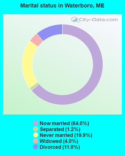
- Never married: 19.9%
- Now married: 64.0%
- Separated: 1.2%
- Widowed: 4.0%
- Divorced: 11.0%
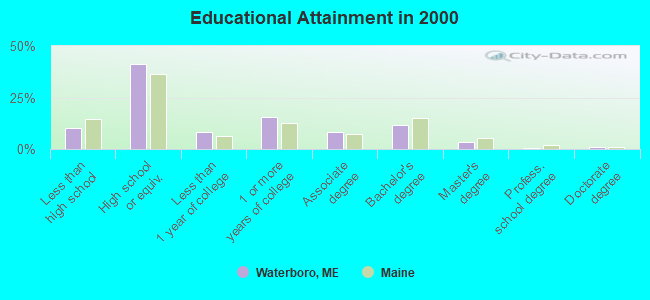
For population 25 years and over in Waterboro:
- High school or higher: 89.9%
- Bachelor's degree or higher: 16.6%
- Graduate or professional degree: 4.8%
- Unemployed: 4.2%
- Mean travel time to work (commute): 34.3 minutes
| Here: | 8.9 |
| Maine average: | 11.2 |


Graphs represent county-level data. Detailed 2008 Election Results
Religion statistics for Waterboro, ME (based on York County data)


| Religion | Adherents | Congregations |
|---|---|---|
| Catholic | 40,283 | 16 |
| Mainline Protestant | 11,480 | 64 |
| Evangelical Protestant | 6,086 | 51 |
| Other | 1,847 | 18 |
| Orthodox | 625 | 3 |
| Black Protestant | 119 | 1 |
| None | 136,691 | - |
Food Environment Statistics:
| Here: | 2.24 / 10,000 pop. |
| Maine: | 2.80 / 10,000 pop. |
| York County: | 0.05 / 10,000 pop. |
| State: | 0.14 / 10,000 pop. |
| York County: | 2.09 / 10,000 pop. |
| Maine: | 2.20 / 10,000 pop. |
| York County: | 4.23 / 10,000 pop. |
| Maine: | 5.75 / 10,000 pop. |
| This county: | 12.53 / 10,000 pop. |
| Maine: | 11.02 / 10,000 pop. |
| This county: | 7.7% |
| Maine: | 8.2% |
| York County: | 24.0% |
| State: | 25.0% |
Businesses in Waterboro, ME
- Dunkin Donuts: 1
- FedEx: 1
- Subway: 1
Strongest AM radio stations in Waterboro:
- WMTW (870 AM; 10 kW; GORHAM, ME; Owner: RADIO PARTNERS OF MAINE, L.P.)
- WGAN (560 AM; 5 kW; PORTLAND, ME; Owner: SAGA COMMUNICATIONS OF NEW ENGLAND, LLC)
- WGIN (930 AM; 10 kW; ROCHESTER, NH; Owner: CAPSTAR TX LIMITED PARTNERSHIP)
- WZAN (970 AM; 5 kW; PORTLAND, ME; Owner: SAGA COMMUNICATIONS OF NEW ENGLAND, LLC)
- WJAE (1440 AM; 5 kW; WESTBROOK, ME; Owner: ALTANTIC COAST RADIO, LLC)
- WRKO (680 AM; 50 kW; BOSTON, MA; Owner: ENTERCOM BOSTON LICENSE, LLC)
- WLOB (1310 AM; 5 kW; PORTLAND, ME; Owner: ATLANTIC COAST RADIO, LLC)
- WEEI (850 AM; 50 kW; BOSTON, MA; Owner: ENTERCOM BOSTON LICENSE, LLC)
- WBZ (1030 AM; 50 kW; BOSTON, MA; Owner: INFINITY BROADCASTING OPERATIONS, INC.)
- WASR (1420 AM; 5 kW; WOLFEBORO, NH; Owner: RADIO WOLFEBORO, INC.)
- WPHX (1220 AM; 1 kW; SANFORD, ME; Owner: FNX BROADCASTING L.L.C.)
- WCRN (830 AM; 50 kW; WORCESTER, MA; Owner: CARTER BROADCASTING CORPORATION)
- WTSN (1270 AM; 5 kW; DOVER, NH; Owner: GARRISON CITY BROADCASTING, INC.)
Strongest FM radio stations in Waterboro:
- WMEA (90.1 FM; PORTLAND, ME; Owner: MAINE PUBLIC BROADCASTING CORPORATION)
- WSCY (106.9 FM; MOULTONBOROUGH, NH; Owner: NORTHEAST COMMUNICATIONS CORPORATION)
- WBLM (102.9 FM; PORTLAND, ME; Owner: CITADEL BROADCASTING COMPANY)
- WPHX-FM (92.1 FM; SANFORD, ME; Owner: FNX BROADCASTING LLC)
- WSEW (88.5 FM; SANFORD, ME; Owner: WORD RADIO EDUCATIONAL FOUNDATION)
- WPKQ (103.7 FM; NORTH CONWAY, NH; Owner: CITADEL BROADCASTING COMPANY)
- WHOM (94.9 FM; MT. WASHINGTON, NH; Owner: CITADEL BROADCASTING COMPANY)
- WCYY (94.3 FM; BIDDEFORD, ME; Owner: CITADEL BROADCASTING COMPANY)
- WJBQ (97.9 FM; PORTLAND, ME; Owner: CITADEL BROADCASTING COMPANY)
- WVFM (105.7 FM; CAMPTON, NH; Owner: DEVON BROADCASTING COMPANY, INC.)
- WRED (95.9 FM; SACO, ME; Owner: ATLANTIC COAST RADIO, LLC)
- WLKZ (104.9 FM; WOLFEBORO, NH; Owner: TELE-MEDIA COMPANY OF NEW HAMPSHIRE, L.L.C.)
- WPOR (101.9 FM; PORTLAND, ME; Owner: SAGA COMMUNICATIONS OF NEW ENGLAND, LLC)
- WMEX (106.5 FM; FARMINGTON, NH; Owner: WIMMEX, LLC)
- WTHT (107.5 FM; LEWISTON, ME; Owner: RADIO PARTNERS OF MAINE, L.P.)
- WUBB (95.3 FM; YORK CENTER, ME; Owner: CAPSTAR TX LIMITED PARTNERSHIP)
- WMTW-FM (106.7 FM; NORTH WINDHAM, ME; Owner: RADIO PARTNERS OF MAINE, L.P.)
- WMSJ (89.3 FM; FREEPORT, ME; Owner: DOWNEAST CHRISTIAN COMMUNICATIONS)
- WBQW (106.3 FM; SCARBOROUGH, ME; Owner: MARINER BROADCASTING LIMITED PARTNER)
- WMPG (90.9 FM; GORHAM, ME; Owner: UNIVERSITY OF MAINE SYSTEM)
TV broadcast stations around Waterboro:
- WMEA-TV (Channel 26; BIDDEFORD, ME; Owner: MAINE PUBLIC BROADCASTING CORP.)
- WMTW-TV (Channel 8; POLAND SPRING, ME; Owner: WMTW BROADCAST GROUP, LLC)
- WCSH (Channel 6; PORTLAND, ME; Owner: PACIFIC AND SOUTHERN COMPANY, INC.)
- WGME-TV (Channel 13; PORTLAND, ME; Owner: WGME LICENSEE, LLC)
- WPXT (Channel 51; PORTLAND, ME; Owner: HMW, INC.)
- WPME (Channel 35; LEWISTON, ME; Owner: KB PRIME MEDIA LLC)
- W32CA (Channel 32; PORTLAND, ME; Owner: NATIONAL MINORITY T.V., INC.)
- National Bridge Inventory (NBI) Statistics
- 4Number of bridges
- 36ft / 11.5mTotal length
- 9,357Total average daily traffic
- 467Total average daily truck traffic
- 12,645Total future (year 2036) average daily traffic
FCC Registered Cell Phone Towers:
1 (See the full list of FCC Registered Cell Phone Towers in Waterboro)FCC Registered Antenna Towers:
11 (See the full list of FCC Registered Antenna Towers)FCC Registered Broadcast Land Mobile Towers:
14 (See the full list of FCC Registered Broadcast Land Mobile Towers in Waterboro, ME)FCC Registered Microwave Towers:
6- WATERBORO, 30 Clark Road (Lat: 43.520611 Lon: -70.663278), Type: Gtower, Structure height: 54.9 m, Call Sign: WMV878,
Assigned Frequencies: 18000.0 MHz, Grant Date: 01/12/2021, Expiration Date: 02/01/2031, Certifier: Carol L Tacker, Registrant: At&t Services, Inc., 208 S Akard St, 20f, Dallas, TX 75202, Phone: (855) 699-7073, Email:
- STATION, Ossipee Mountain (Lat: 43.587833 Lon: -70.738944), Overall height: 24.4 m, Call Sign: WNTI554,
Assigned Frequencies: 958.150 MHz, Grant Date: 01/23/2021, Expiration Date: 01/25/2031, Registrant: State Of Maine, O.I.T., Radio Operations, 66 Industrial Drive, Augusta, ME 04333-0147, Phone: (207) 624-9990, Email:
- OSSIPEE, Ossipee Hill Road (Lat: 43.587833 Lon: -70.739361), Type: Mast, Structure height: 54.9 m, Call Sign: WQNK965,
Assigned Frequencies: 6093.45 MHz, 6123.10 MHz, 943.375 MHz, 6004.50 MHz, 6093.45 MHz, 6123.10 MHz, 6815.00 MHz, 6093.45 MHz, 6123.10 MHz, 6815.00 MHz... (+18 more), Grant Date: 01/27/2021, Expiration Date: 03/10/2031, Certifier: David E Mars, Registrant: State Of Maine, O.I.T., Radio Operations, 66 Industrial Drive, Augusta, ME 04333-0147, Phone: (207) 624-9990, Email:
- OSSIPEE MT, 255 Mountain Road (Lat: 43.587806 Lon: -70.739528), Type: Gtower, Structure height: 54.9 m, Call Sign: WQPX253,
Assigned Frequencies: 6152.75 MHz, 6152.75 MHz, 6152.75 MHz, 6152.75 MHz, 6152.75 MHz, 6152.75 MHz, 6152.75 MHz, 6152.75 MHz, Grant Date: 07/27/2022, Expiration Date: 09/06/2032, Certifier: James Kowalik, Registrant: Nh Dept Of Safety/ Emergency Services & Communications, 33 Hazen Dr (Mailing), Concord, NH 03305, Phone: (603) 528-7541, Fax: (603) 271-6629, Email:
- WATERBOROMTN, Mountain Rd (Lat: 43.591750 Lon: -70.741667), Type: Ltower, Structure height: 54.9 m, Overall height: 55.5 m, Call Sign: WQUG399,
Assigned Frequencies: 11505.0 MHz, 11545.0 MHz, 11425.0 MHz, Grant Date: 06/30/2014, Expiration Date: 06/30/2024, Certifier: John E Monday, Registrant: At&t Services, Inc., 208 S Akard St, 20f, Dallas, TX 75202, Phone: (855) 699-7073, Fax: (214) 746-6410, Email:
- STATION, Ossipee Mountain (Lat: 43.587833 Lon: -70.738944), Overall height: 36.6 m, Call Sign: WBH339,
Assigned Frequencies: 6745.00 MHz, 6785.00 MHz, Grant Date: 10/23/2019, Expiration Date: 11/17/2029, Registrant: State Of Maine, O.I.T., Radio Operations, 66 Industrial Drive, Augusta, ME 04333-0147, Phone: (207) 624-9990, Email:
FCC Registered Amateur Radio Licenses:
27 (See the full list of FCC Registered Amateur Radio Licenses in Waterboro)FAA Registered Aircraft:
2- Aircraft: VIKING UNMANNED AERIAL SYSTEMS VK-450 (Category: Land, Engines: 4), Engine: Electric
N-Number: 327XC, N327XC, N-327XC, Serial Number: VK-007-0004, Certificate Issue Date: 04/19/2016
Registrant (Corporation): Xcam Aerial Solutions Inc, Po Box 372, Waterboro, ME 04087
Deregistered: Cancel Date: 09/06/2019 - Aircraft: VIKING UNMANNED AERIAL SYSTEMS VK-MULTIROTOR X4-XC (Category: Land, Engines: 4), Engine: Electric
N-Number: 427XC, N427XC, N-427XC, Serial Number: VK-009-0001, Certificate Issue Date: 03/14/2016
Registrant (Corporation): X Cam Aerial Solutions Inc, Po Box 372, Waterboro, ME 04087
Deregistered: Cancel Date: 09/06/2019
2003 - 2018 National Fire Incident Reporting System (NFIRS) incidents
- Fire incident types reported to NFIRS in Waterboro, ME
- 16255.7%Structure Fires
- 8328.5%Outside Fires
- 4214.4%Mobile Property/Vehicle Fires
- 41.4%Other
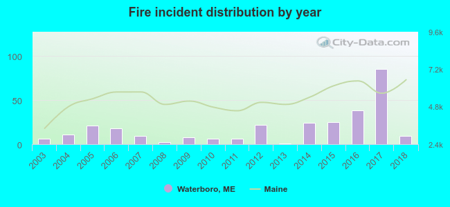 Based on the data from the years 2003 - 2018 the average number of fires per year is 18. The highest number of reported fires - 85 took place in 2017, and the least - 1 in 2013. The data has a growing trend.
 When looking into fire subcategories, the most incidents belonged to: Structure Fires (55.7%), and Outside Fires (28.5%).
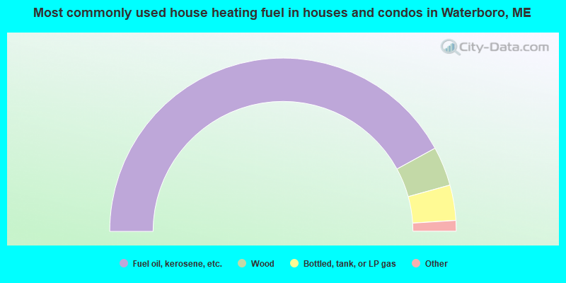
- 84.1%Fuel oil, kerosene, etc.
- 7.3%Wood
- 6.6%Bottled, tank, or LP gas
- 1.7%Electricity
- 0.3%Utility gas
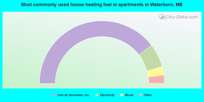
- 78.9%Fuel oil, kerosene, etc.
- 12.4%Electricity
- 4.3%Wood
- 2.7%Other fuel
- 1.7%Bottled, tank, or LP gas
Waterboro compared to Maine state average:
- Unemployed percentage significantly below state average.
- Black race population percentage significantly below state average.
- Hispanic race population percentage below state average.
- Median age below state average.
- Foreign-born population percentage significantly below state average.
- Renting percentage below state average.
- Length of stay since moving in significantly above state average.
- Number of rooms per house significantly below state average.
- House age significantly below state average.
- Percentage of population with a bachelor's degree or higher below state average.
Waterboro on our top lists:
- #6 on the list of "Top 101 cities with largest percentage of females in occupations: special education teachers (population 5,000+)"
- #15 on the list of "Top 101 cities with largest percentage of males in occupations: laborers and material movers, hand (population 5,000+)"
- #16 on the list of "Top 101 cities with largest percentage of females in industries: printing and related support activities (population 5,000+)"
- #17 on the list of "Top 101 cities with largest percentage of females in occupations: other transportation workers (population 5,000+)"
- #21 on the list of "Top 101 cities with largest percentage of males in industries: motor vehicles, parts and supplies merchant wholesalers (population 5,000+)"
- #23 on the list of "Top 101 cities with largest percentage of females in industries: health and personal care, except drug, stores (population 5,000+)"
- #27 on the list of "Top 101 cities with largest percentage of males in occupations: carpenters (population 5,000+)"
- #28 on the list of "Top 101 cities with largest percentage of males in occupations: therapists (population 5,000+)"
- #30 on the list of "Top 101 cities with largest percentage of females in industries: office supplies and stationery stores (population 5,000+)"
- #31 on the list of "Top 101 cities with largest percentage of females in industries: leather and allied products (population 5,000+)"
- #39 on the list of "Top 101 cities with largest percentage of males in industries: u. s. postal service (population 5,000+)"
- #43 on the list of "Top 101 cities with largest percentage of females in occupations: metal workers and plastic workers (population 5,000+)"
- #49 on the list of "Top 101 cities with largest percentage of females in industries: lumber and other construction materials merchant wholesalers (population 5,000+)"
- #55 on the list of "Top 101 cities with largest percentage of females in industries: electrical and electronic goods merchant wholesalers (population 5,000+)"
- #63 on the list of "Top 101 cities with largest percentage of males in industries: groceries and related products merchant wholesalers (population 5,000+)"
- #65 on the list of "Top 101 cities with largest percentage of females in industries: gasoline stations (population 5,000+)"
- #74 on the list of "Top 101 cities with largest percentage of females in industries: groceries and related products merchant wholesalers (population 5,000+)"
- #77 on the list of "Top 101 cities with largest percentage of females in industries: textile mills and textile products (population 5,000+)"
- #78 on the list of "Top 101 cities with largest percentage of males in industries: recyclable material merchant wholesalers (population 5,000+)"
- #79 on the list of "Top 101 cities with largest percentage of females in industries: computer and electronic products (population 5,000+)"
- #21 on the list of "Top 101 counties with the highest percentage of residents that smoked 100+ cigarettes in their lives"
- #35 on the list of "Top 101 counties with the lowest number of births per 1000 residents 2007-2013"
- #70 on the list of "Top 101 counties with the highest percentage of residents that keep firearms around their homes"
- #77 on the list of "Top 101 counties with the best general health status score of residents (1-5), 3 years of data"

|
|
Total of 8 patent applications in 2008-2024.