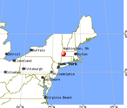
Washington, Massachusetts
Submit your own pictures of this town and show them to the world
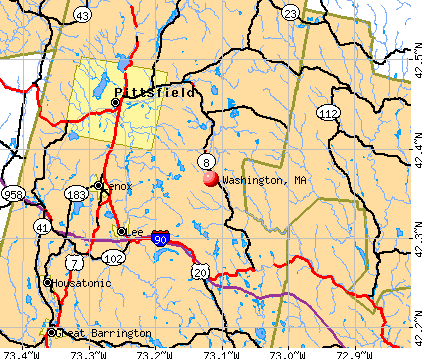
- OSM Map
- General Map
- Google Map
- MSN Map
Population change since 2000: -1.1%
 |
| Males: 273 | |
| Females: 265 |
| Median resident age: | 49.4 years |
| Massachusetts median age: | 39.2 years |
Zip codes: 01223.
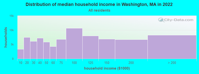
| Washington: | $103,689 |
| MA: | $94,488 |
Estimated per capita income in 2022: $52,957 (it was $23,610 in 2000)
Washington town income, earnings, and wages data
Estimated median house or condo value in 2022: $335,344 (it was $125,400 in 2000)
| Washington: | $335,344 |
| MA: | $534,700 |
Mean prices in 2022: all housing units: $357,971; detached houses: $376,086; townhouses or other attached units: $341,816; in 2-unit structures: $250,940; in 3-to-4-unit structures: $400,871; in 5-or-more-unit structures: $281,990; mobile homes: $80,872
Detailed information about poverty and poor residents in Washington, MA


- 52697.8%White alone
- 101.9%Hispanic
- 10.2%Black alone
- 10.2%Two or more races
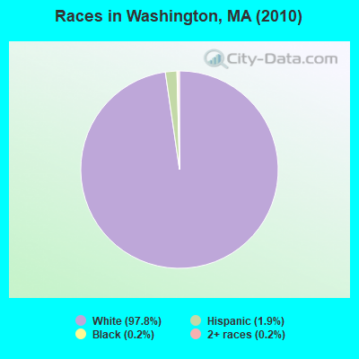
Races in Washington detailed stats: ancestries, foreign born residents, place of birth
According to our research of Massachusetts and other state lists, there was 1 registered sex offender living in Washington, Massachusetts as of May 22, 2024.
The ratio of all residents to sex offenders in Washington is 538 to 1.
 Recent articles from our blog. Our writers, many of them Ph.D. graduates or candidates, create easy-to-read articles on a wide variety of topics.


 | How About Those Patriots? (1187 replies) |
| 2023 Real Estate Observations (5278 replies) |
| Is Roxbury safe? Looking to move to new apartment on Washington st. (56 replies) |
| The worst winter in Massachusetts. Is the weather bothering you? (285 replies) |
| Boston crime thread - all posts go here. (2497 replies) |
| 2021 Real Estate Observations (1729 replies) |
Latest news from Washington, MA collected exclusively by city-data.com from local newspapers, TV, and radio stations
Ancestries: Irish (23.7%), French (20.2%), English (16.0%), German (15.3%), Italian (11.9%), French Canadian (9.4%).
Current Local Time: EST time zone
Incorporated in 1777
Elevation: 1412 feet
Land area: 37.8 square miles.
Population density: 14 people per square mile (very low).
8 residents are foreign born
| This town: | 1.5% |
| Massachusetts: | 12.2% |
| Washington town: | 1.1% ($1,408) |
| Massachusetts: | 1.3% ($2,336) |
Nearest city with pop. 50,000+: Chicopee, MA  (32.1 miles , pop. 54,653).
Nearest city with pop. 200,000+: Boston, MA (105.7 miles , pop. 589,141).
Nearest city with pop. 1,000,000+: Bronx, NY (111.5 miles , pop. 1,332,650).
Nearest cities:
), ), ), ), Latitude: 42.37 N, Longitude: 73.16 W
Area code commonly used in this area: 413

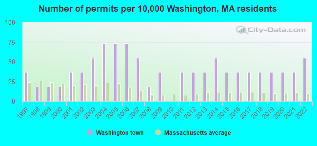
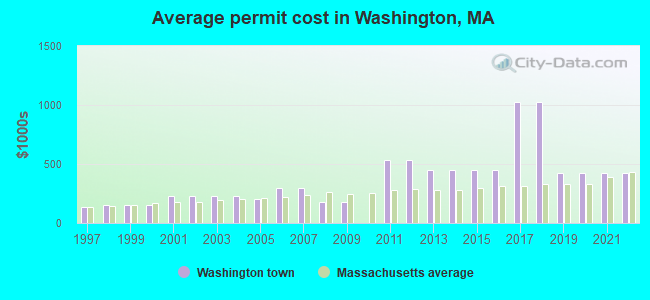
Single-family new house construction building permits:
- 2022: 3 buildings, average cost: $425,000
- 2021: 2 buildings, average cost: $425,000
- 2020: 2 buildings, average cost: $425,000
- 2019: 2 buildings, average cost: $425,000
- 2018: 2 buildings, average cost: $1,025,000
- 2017: 2 buildings, average cost: $1,025,000
- 2016: 2 buildings, average cost: $450,000
- 2015: 2 buildings, average cost: $450,000
- 2014: 3 buildings, average cost: $450,000
- 2013: 2 buildings, average cost: $450,000
- 2012: 2 buildings, average cost: $537,500
- 2011: 2 buildings, average cost: $537,500
- 2009: 2 buildings, average cost: $182,400
- 2008: 1 building, cost: $182,400
- 2007: 3 buildings, average cost: $300,000
- 2006: 4 buildings, average cost: $300,000
- 2005: 4 buildings, average cost: $206,500
- 2004: 4 buildings, average cost: $225,000
- 2003: 3 buildings, average cost: $225,000
- 2002: 2 buildings, average cost: $225,000
- 2001: 2 buildings, average cost: $225,000
- 2000: 1 building, cost: $150,000
- 1999: 1 building, cost: $150,000
- 1998: 1 building, cost: $150,000
- 1997: 2 buildings, average cost: $137,500
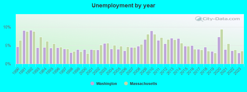
| Here: | 3.0% |
| Massachusetts: | 3.5% |
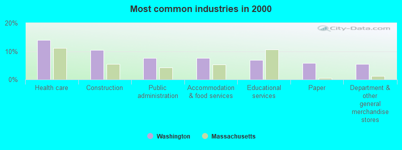
- Health care (13.9%)
- Construction (10.5%)
- Public administration (7.7%)
- Accommodation & food services (7.7%)
- Educational services (7.0%)
- Paper (5.9%)
- Department & other general merchandise stores (5.6%)
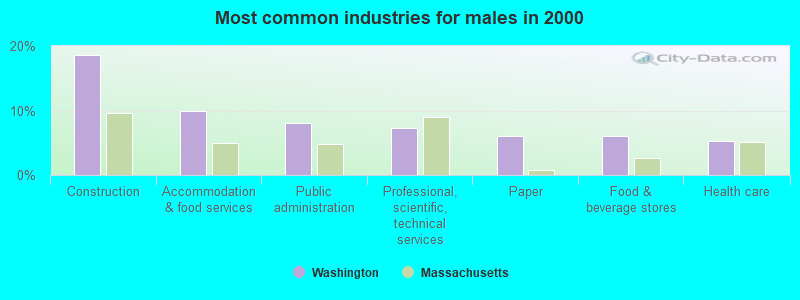
- Construction (18.7%)
- Accommodation & food services (10.0%)
- Public administration (8.0%)
- Professional, scientific, technical services (7.3%)
- Paper (6.0%)
- Food & beverage stores (6.0%)
- Health care (5.3%)
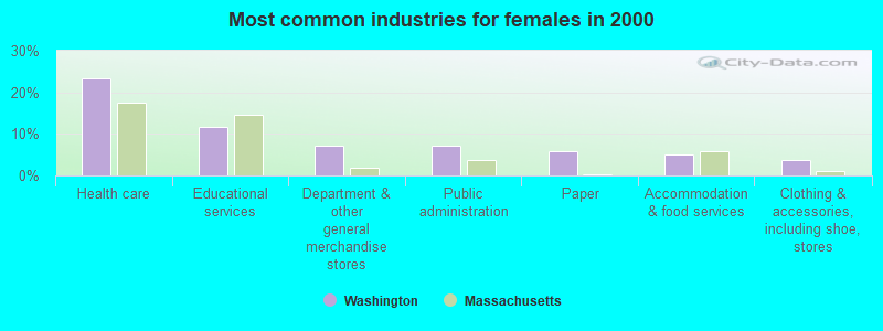
- Health care (23.4%)
- Educational services (11.7%)
- Department & other general merchandise stores (7.3%)
- Public administration (7.3%)
- Paper (5.8%)
- Accommodation & food services (5.1%)
- Clothing & accessories, including shoe, stores (3.6%)
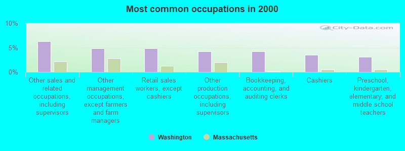
- Other sales and related occupations, including supervisors (6.3%)
- Other management occupations, except farmers and farm managers (4.9%)
- Retail sales workers, except cashiers (4.9%)
- Other production occupations, including supervisors (4.2%)
- Bookkeeping, accounting, and auditing clerks (4.2%)
- Cashiers (3.5%)
- Preschool, kindergarten, elementary, and middle school teachers (3.1%)
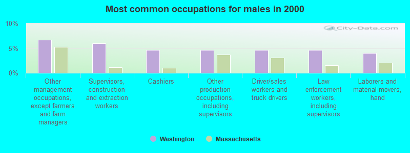
- Other management occupations, except farmers and farm managers (6.7%)
- Supervisors, construction and extraction workers (6.0%)
- Cashiers (4.7%)
- Other production occupations, including supervisors (4.7%)
- Driver/sales workers and truck drivers (4.7%)
- Law enforcement workers, including supervisors (4.7%)
- Laborers and material movers, hand (4.0%)
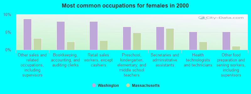
- Other sales and related occupations, including supervisors (8.8%)
- Bookkeeping, accounting, and auditing clerks (8.0%)
- Retail sales workers, except cashiers (8.0%)
- Preschool, kindergarten, elementary, and middle school teachers (6.6%)
- Secretaries and administrative assistants (6.6%)
- Health technologists and technicians (5.1%)
- Other food preparation and serving workers, including supervisors (5.1%)
Average climate in Washington, Massachusetts
Based on data reported by over 4,000 weather stations


(lower is better)
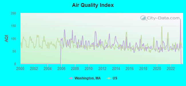
Air Quality Index (AQI) level in 2022 was 63.5. This is about average.
| City: | 63.5 |
| U.S.: | 72.6 |
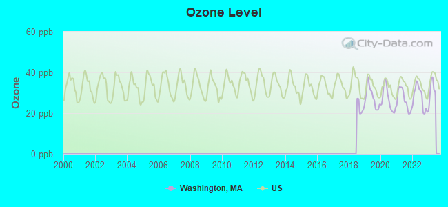
Ozone [ppb] level in 2022 was 27.5. This is better than average. Closest monitor was 6.4 miles away from the city center.
| City: | 27.5 |
| U.S.: | 33.3 |
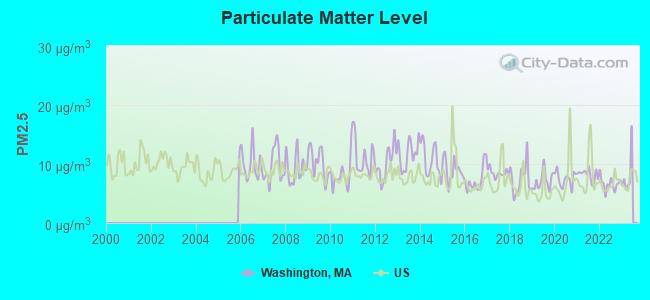
Particulate Matter (PM2.5) [µg/m3] level in 2022 was 6.65. This is better than average. Closest monitor was 7.3 miles away from the city center.
| City: | 6.65 |
| U.S.: | 8.11 |
Tornado activity:
Washington-area historical tornado activity is slightly above Massachusetts state average. It is 17% smaller than the overall U.S. average.
On 8/28/1973, a category F4 (max. wind speeds 207-260 mph) tornado 13.3 miles away from the Washington town center killed 4 people and injured 36 people and caused between $5,000,000 and $50,000,000 in damages.
On 5/29/1995, a category F4 tornado 13.6 miles away from the town center killed 3 people and injured 24 people and caused between $5,000,000 and $50,000,000 in damages.
Earthquake activity:
Washington-area historical earthquake activity is significantly above Massachusetts state average. It is 69% smaller than the overall U.S. average.On 10/7/1983 at 10:18:46, a magnitude 5.3 (5.1 MB, 5.3 LG, 5.1 ML, Class: Moderate, Intensity: VI - VII) earthquake occurred 125.0 miles away from Washington center
On 4/20/2002 at 10:50:47, a magnitude 5.3 (5.3 ML, Depth: 3.0 mi) earthquake occurred 150.9 miles away from the city center
On 4/20/2002 at 10:50:47, a magnitude 5.2 (5.2 MB, 4.2 MS, 5.2 MW, 5.0 MW) earthquake occurred 149.3 miles away from the city center
On 1/19/1982 at 00:14:42, a magnitude 4.7 (4.5 MB, 4.7 MD, 4.5 LG, Class: Light, Intensity: IV - V) earthquake occurred 111.2 miles away from the city center
On 10/16/2012 at 23:12:25, a magnitude 4.7 (4.7 ML, Depth: 10.0 mi) earthquake occurred 152.5 miles away from the city center
On 6/17/1991 at 08:53:16, a magnitude 4.1 (4.0 MB, 4.0 LG, Depth: 3.1 mi) earthquake occurred 79.7 miles away from the city center
Magnitude types: regional Lg-wave magnitude (LG), body-wave magnitude (MB), duration magnitude (MD), local magnitude (ML), surface-wave magnitude (MS), moment magnitude (MW)
Natural disasters:
The number of natural disasters in Berkshire County (21) is greater than the US average (15).Major Disasters (Presidential) Declared: 10
Emergencies Declared: 10
Causes of natural disasters: Floods: 5, Snowstorms: 5, Storms: 5, Hurricanes: 4, Winter Storms: 4, Blizzards: 2, Snows: 2, Snowfall: 1, Tropical Storm: 1, Wind: 1, Other: 1 (Note: some incidents may be assigned to more than one category).

Hospitals and medical centers in Washington:
Other hospitals and medical centers near Washington:
- NURSING CARE CENTER AT KIMBALL (Nursing Home, about 6 miles away; LENOX, MA)
- KINDRED NURSING AND REHABILITATION-LAUREL LAKE (Nursing Home, about 7 miles away; LEE, MA)
- VALLEY VIEW NURSING HOME (Nursing Home, about 7 miles away; LENOX, MA)
- PROVIDENCE CARE CENTER - LENOX (Nursing Home, about 7 miles away; LENOX, MA)
- LEE REGIONAL VNA INC. (Home Health Center, about 7 miles away; LEE, MA)
- EDGECOMBE NURSING HOME (Nursing Home, about 7 miles away; LENOX, MA)
- KIMBALL FARMS NURSING CARE CENTER (Nursing Home, about 7 miles away; LENOX, MA)
Airports located in Washington:
- Blueberry Hill Airport (MA77) (Runways: 1)
Colleges/universities with over 2000 students nearest to Washington:
- Williams College (about 24 miles; Williamstown, MA; Full-time enrollment: 2,141)
- Westfield State University (about 25 miles; Westfield, MA; FT enrollment: 5,548)
- Smith College (about 27 miles; Northampton, MA; FT enrollment: 3,549)
- Holyoke Community College (about 29 miles; Holyoke, MA; FT enrollment: 4,911)
- Mount Holyoke College (about 31 miles; South Hadley, MA; FT enrollment: 2,573)
- University of Massachusetts-Amherst (about 33 miles; Amherst, MA; FT enrollment: 26,583)
- Springfield Technical Community College (about 35 miles; Springfield, MA; FT enrollment: 4,750)
Points of interest:
Notable locations in Washington: Bucksteep Cross-Country Ski Area (A), Washington Fire Department (B). Display/hide their locations on the map
Church in Washington: Saint Andrews Chapel (A). Display/hide its location on the map
Cemetery: Washington Cemetery (1). Display/hide its location on the map
Lakes and reservoirs: Benson Pond (A), Muddy Pond (B), Halfway Pond (C), Clapp Pond (D), Mud Pond (E), Sandwash Reservoir (F), Washington Mountain Lake (G), Ashley Lake (H). Display/hide their locations on the map
Park in Washington: Pittsfield State Watershed Area (1). Display/hide its location on the map
Birthplace of: Edwin D. Morgan - politician.
| This town: | 2.4 people |
| Massachusetts: | 2.5 people |
| This town: | 73.8% |
| Whole state: | 63.0% |
| This town: | 7.6% |
| Whole state: | 7.0% |
Likely homosexual households (counted as self-reported same-sex unmarried-partner households)
- Lesbian couples: 0.4% of all households
- Gay men: 0.4% of all households
| This town: | 6.9% |
| Whole state: | 9.3% |
| This town: | 4.0% |
| Whole state: | 4.4% |
For population 15 years and over in Washington:
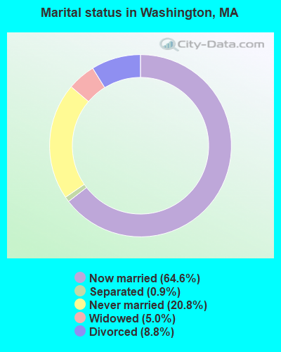
- Never married: 20.8%
- Now married: 64.6%
- Separated: 0.9%
- Widowed: 5.0%
- Divorced: 8.8%
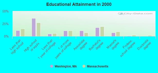
For population 25 years and over in Washington:
- High school or higher: 88.4%
- Bachelor's degree or higher: 25.4%
- Graduate or professional degree: 7.9%
- Unemployed: 4.7%
- Mean travel time to work (commute): 27.8 minutes
| Here: | 10.3 |
| Massachusetts average: | 13.1 |


Graphs represent county-level data. Detailed 2008 Election Results
Religion statistics for Washington, MA (based on Berkshire County data)


| Religion | Adherents | Congregations |
|---|---|---|
| Catholic | 50,187 | 32 |
| Mainline Protestant | 9,895 | 63 |
| Other | 3,647 | 20 |
| Evangelical Protestant | 2,817 | 28 |
| Black Protestant | 233 | 2 |
| Orthodox | 225 | 2 |
| None | 64,215 | - |
Food Environment Statistics:
| This county: | 2.54 / 10,000 pop. |
| Massachusetts: | 1.98 / 10,000 pop. |
| This county: | 1.61 / 10,000 pop. |
| Massachusetts: | 2.22 / 10,000 pop. |
| This county: | 4.08 / 10,000 pop. |
| State: | 1.77 / 10,000 pop. |
| Here: | 15.00 / 10,000 pop. |
| Massachusetts: | 8.76 / 10,000 pop. |
| Berkshire County: | 8.0% |
| State: | 8.1% |
| Berkshire County: | 22.8% |
| Massachusetts: | 22.5% |
| Berkshire County: | 9.9% |
| Massachusetts: | 16.5% |
Strongest AM radio stations in Washington:
- WNNZ (640 AM; 50 kW; WESTFIELD, MA; Owner: CLEAR CHANNEL BROADCASTING LICENSES, INC.)
- WUHN (1110 AM; daytime; 5 kW; PITTSFIELD, MA; Owner: WEINER BROADCASTING, INC.)
- WTIC (1080 AM; 50 kW; HARTFORD, CT; Owner: INFINITY RADIO OPERATIONS INC.)
- WGY (810 AM; 50 kW; SCHENECTADY, NY; Owner: CLEAR CHANNEL BROADCASTING LICENSES, INC.)
- WBRK (1340 AM; 1 kW; PITTSFIELD, MA; Owner: WBRK, INC.)
- WPTR (1540 AM; 50 kW; ALBANY, NY; Owner: KIMTRON, INC.)
- WSBS (860 AM; 3 kW; GREAT BARRINGTON, MA; Owner: BERKSHIRE BROADCASTING CO., INC.)
- WCRN (830 AM; 50 kW; WORCESTER, MA; Owner: CARTER BROADCASTING CORPORATION)
- WHYN (560 AM; 5 kW; SPRINGFIELD, MA; Owner: CLEAR CHANNEL BROADCASTING LICENSES, INC.)
- WBEC (1420 AM; 1 kW; PITTSFIELD, MA; Owner: GREAT NORTHERN RADIO, LLC)
- WVNE (760 AM; daytime; 25 kW; LEICESTER, MA; Owner: BLOUNT MASSCOM, INC.)
- WRKO (680 AM; 50 kW; BOSTON, MA; Owner: ENTERCOM BOSTON LICENSE, LLC)
- WACE (730 AM; 5 kW; CHICOPEE, MA; Owner: CARTER BROADCASTING CORP.)
Strongest FM radio stations in Washington:
- WBEC-FM (105.5 FM; PITTSFIELD, MA; Owner: GREAT NORTHERN RADIO, LLC)
- WAMC-FM (90.3 FM; ALBANY, NY; Owner: WAMC)
- WUPE (95.9 FM; PITTSFIELD, MA; Owner: WEINER BROADCASTING, INC.)
- WHVP (91.1 FM; HUDSON, NY; Owner: SOUND OF LIFE, INC.)
- WAMQ (105.1 FM; GREAT BARRINGTON, MA; Owner: WAMC)
- WHYN-FM (93.1 FM; SPRINGFIELD, MA; Owner: CLEAR CHANNEL BROADCASTING LICENSES, INC.)
- WZEC (97.5 FM; HOOSICK FALLS, NY; Owner: GREAT NORTHERN RADIO, LLC)
- WEQX (102.7 FM; MANCHESTER, VT; Owner: NORTHSHIRE COMMUNICATIONS, INC.)
- WJAN (95.1 FM; SUNDERLAND, VT; Owner: 6 JOHNSON ROAD LICENSES, INC.)
- WRNX (100.9 FM; AMHERST, MA; Owner: WESTERN MASSACHUSETTS RADIO COMPANY)
- WVAY (100.7 FM; WILMINGTON, VT; Owner: GREAT NORTHERN RADIO, L.L.C.)
- WAQY (102.1 FM; SPRINGFIELD, MA; Owner: SAGA COMMUNICATIONS OF NEW ENGLAND, LLC)
- WFCR (88.5 FM; AMHERST, MA; Owner: UNIVERSITY OF MASSACHUSETTS)
- WAMK (90.9 FM; KINGSTON, NY; Owner: W A M C)
- WFGB (89.7 FM; KINGSTON, NY; Owner: SOUND OF LIFE, INC.)
- WMNB (100.1 FM; NORTH ADAMS, MA; Owner: BERKSHIRE BROADCASTING CO., INC.)
- WBRK-FM (101.7 FM; PITTSFIELD, MA; Owner: WBRK, INC.)
- WRCH (100.5 FM; NEW BRITAIN, CT; Owner: INFINITY RADIO OPERATIONS INC.)
- WAJZ (96.3 FM; VOORHEESVILLE, NY; Owner: 6 JOHNSON ROAD LICENSES, INC.)
- WPVQ (95.3 FM; GREENFIELD, MA; Owner: GREAT NORTHERN RADIO, L.L.C.)
TV broadcast stations around Washington:
- WTIC-TV (Channel 61; HARTFORD, CT; Owner: TRIBUNE TELEVISION COMPANY)
- W11BJ (Channel 11; HARTFORD, CT; Owner: COMMUNICATIONS SITE MANAGEMENT LLC)
- WTXX (Channel 20; WATERBURY, CT; Owner: WTXX INC.)
- WUVN (Channel 18; HARTFORD, CT; Owner: ENTRAVISION HOLDINGS, LLC)
- WWLP (Channel 22; SPRINGFIELD, MA; Owner: WWLP BROADCASTING, LLC)
- WCDC-TV (Channel 19; ADAMS, MA; Owner: YOUNG BROADCASTING OF ALBANY, INC.)
- W35BK (Channel 35; PLAINFIELD, MA; Owner: LYDIA SYLVANE STOCKWELL)
- W38DL (Channel 38; ADAMS, ETC., MA; Owner: WNYT-TV, LLC)
- W07AI (Channel 7; PITTSFIELD, ETC., MA; Owner: WNYT-TV, LLC)
Washington fatal accident list:
Jul 30, 1988 06:50 AM, Pittsfield, Vehicles: 1, Persons: 1, Fatalities: 1
Sep 16, 1979 01:20 AM, Vehicles: 1, Persons: 1, Fatalities: 1, Drunk persons involved: 1
- National Bridge Inventory (NBI) Statistics
- 6Number of bridges
- 20ft / 6.3mTotal length
- $1,974,000Total costs
- 1,123Total average daily traffic
- 23Total average daily truck traffic
FCC Registered Antenna Towers:
4- Kurt R Jackson, Off Mt.Washington Rd (Lat: 42.388139 Lon: -73.158139), Type: 76.0, Overall height: 76 m, Registrant: President, Charl-ton, Phone: (508) 248-9732
- KURT R JACKSON, Off Mt.Washington Rd (Lat: 42.388139 Lon: -73.158139), Type: 76.0, Overall height: 76 m, Registrant: Pitts-field, Phone: (413) 499-1441
- Douglas Norton, Off Mt.Washington Rd (Lat: 42.388139 Lon: -73.158139), Type: 76.0, Structure height: 25003 m, Overall height: 76 m, Registrant: Accessplus Communication, Inc., Dnorton@accesspluscom.Com, , Byfie-ld, Phone: (978) 732-7112
- Kevin Alward, Off Mt.Washington Rd (Lat: 42.388139 Lon: -73.158139), Type: 76.0, Structure height: 25003 m, Overall height: 76 m, Registrant: Ringsquared Apc LLC, Kevin.Alward@dial800.Com, Suite 4, Mahwa-h, Phone: (212) 277-8040
FCC Registered Broadcast Land Mobile Towers:
4- Pittsfield Rd 3.25 Mi Se Dalton (Lat: 42.373694 Lon: -73.147333), Type: Tower, Structure height: 28 m, Call Sign: KCA426,
Assigned Frequencies: 48.0400 MHz, 173.300 MHz, Grant Date: 12/29/2005, Expiration Date: 01/09/2016, Cancellation Date: 03/16/2012, Registrant: Keller And Heckman LLP, 1001 G Street Nw, Suite 500 West, Washington, DC 20001, Phone: (202) 434-4100, Fax: (202) 434-4646, Email:
- 3.25 Mi Ese Of Dalton On Pittsfield Rd (Lat: 42.373694 Lon: -73.147333), Call Sign: KNBH640,
Assigned Frequencies: 153.695 MHz, Grant Date: 08/10/2011, Expiration Date: 09/19/2021, Cancellation Date: 07/13/2021, Registrant: Keller And Heckman LLP, 1001 G Street Nw, Suite 500 West, Washington, DC 20001, Phone: (202) 434-4100, Fax: (202) 434-4646, Email:
- Pittsfield Rd 3.2 Mi Se Of Dalton Line (Lat: 42.373694 Lon: -73.147333), Call Sign: WBC79,
Assigned Frequencies: 154.463 MHz, 154.463 MHz, Grant Date: 11/09/2023, Expiration Date: 11/24/2033, Registrant: Keller And Heckman LLP, 1001 G Street Nw, Suite 500 West, Washington, DC 20001, Phone: (202) 434-4100, Fax: (202) 434-4646, Email:
- Pittsfield Rd 3.25 Mi Se Dalton (Lat: 42.373694 Lon: -73.147333), Type: Tower, Structure height: 27 m, Call Sign: WNFU945,
Assigned Frequencies: 47.7600 MHz, Grant Date: 10/21/2022, Expiration Date: 12/09/2032, Registrant: Keller And Heckman LLP, 1001 G Street Nw, Suite 500, Washington, DC 20001, Phone: (202) 434-4100, Fax: (202) 434-4646, Email:
FCC Registered Microwave Towers:
8 (See the full list of FCC Registered Microwave Towers in this town)FCC Registered Paging Towers:
1 (See the full list of FCC Registered Paging Towers)FCC Registered Amateur Radio Licenses:
4- Call Sign: K1CPG, Grant Date: 12/14/1993, Expiration Date: 12/14/2003, Cancellation Date: 12/15/2005, Registrant: Harvey E Fish Sr, Pittsfield Rd, Washington, MA 01223
- Call Sign: KB1BLQ, Grant Date: 03/17/1995, Expiration Date: 12/01/2004, Cancellation Date: 12/02/2006, Registrant: Harvey E Fish Jr, 629 Washington Mtn Rd, Washington, MA 01223
- Call Sign: KB1JOA, Licensee ID: L00652562, Grant Date: 03/14/2023, Expiration Date: 03/14/2033, Certifier: Philip G Clark, Registrant: Philip G Clark, 169 Upper Valley Rd, Washington, MA 01223
- Call Sign: KC1BYC, Licensee ID: L01867977, Grant Date: 05/21/2014, Expiration Date: 05/21/2024, Certifier: Paul M Costelloe, Registrant: Paul M Costelloe, 512 Middlefield Rd, Washington, MA 01223
FAA Registered Aircraft:
1- Aircraft: PIPER PA-16 (Category: Land, Seats: 4, Weight: Up to 12,499 Pounds, Speed: 87 mph), Engine: LYCOMING 0-235 SERIES (115 HP) (Reciprocating)
N-Number: 6847K, N6847K, N-6847K, Serial Number: 16-681, Year manufactured: 1949, Airworthiness Date: 11/15/1955, Certificate Issue Date: 07/14/1973
Registrant (Individual): Roy J Wiley, 47 Washington Mountain Rd, Washington, MA 01223
Deregistered: Cancel Date: 06/08/2018
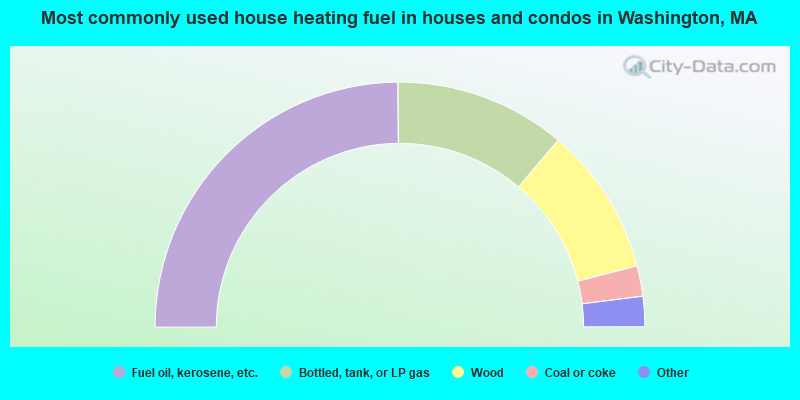
- 49.7%Fuel oil, kerosene, etc.
- 22.6%Bottled, tank, or LP gas
- 19.6%Wood
- 4.0%Coal or coke
- 2.5%Utility gas
- 1.5%Electricity
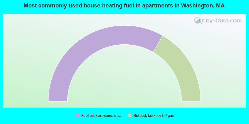
- 66.7%Fuel oil, kerosene, etc.
- 33.3%Bottled, tank, or LP gas
Washington compared to Massachusetts state average:
- Median house value below state average.
- Unemployed percentage significantly below state average.
- Black race population percentage significantly below state average.
- Hispanic race population percentage significantly below state average.
- Median age significantly above state average.
- Foreign-born population percentage significantly below state average.
- Renting percentage significantly below state average.
- Length of stay since moving in significantly above state average.
- Number of rooms per house significantly below state average.
- House age significantly below state average.

|
Total of 2 patent applications in 2008-2024.