Warm Springs-Truckee Canyon, Nevada
Submit your own pictures of this place and show them to the world
- OSM Map
- Google Map
- MSN Map
| Males: 13,087 | |
| Females: 13,160 |
| Median resident age: | 34.6 years |
| Nevada median age: | 35.0 years |
Zip code: 89436
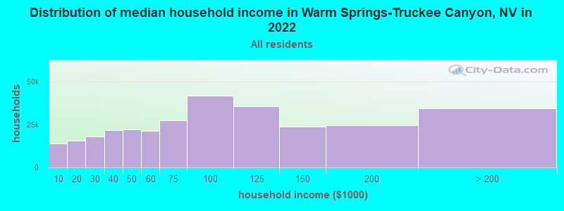
| Warm Springs-Truckee Canyon: | $121,031 |
| NV: | $72,333 |
Estimated per capita income in 2022: $49,449 (it was $26,578 in 2000)
Warm Springs-Truckee Canyon CCD income, earnings, and wages data
Estimated median house or condo value in 2022: $630,449 (it was $177,700 in 2000)
| Warm Springs-Truckee Canyon: | $630,449 |
| NV: | $434,700 |
Mean prices in 2022: all housing units: $613,067; detached houses: $676,960; townhouses or other attached units: $384,722; in 3-to-4-unit structures: $610,331; in 5-or-more-unit structures: $303,040; mobile homes: $180,941; occupied boats, rvs, vans, etc.: $38,281
Warm Springs-Truckee Canyon, NV residents, houses, and apartments details
Detailed information about poverty and poor residents in Warm Springs-Truckee Canyon, NV


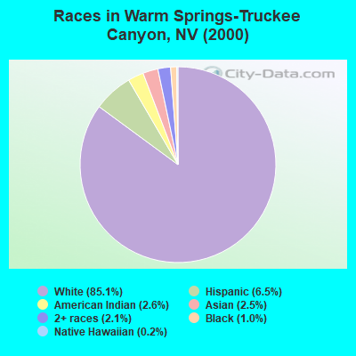
- 18,76385.1%White alone
- 1,4306.5%Hispanic
- 5682.6%American Indian alone
- 5582.5%Asian alone
- 4582.1%Two or more races
- 2221.0%Black alone
- 400.2%Native Hawaiian and Other
Pacific Islander alone - 150.07%Other race alone
 Recent articles from our blog. Our writers, many of them Ph.D. graduates or candidates, create easy-to-read articles on a wide variety of topics.
Current Local Time: PST time zone
Land area: 518.9 square miles.
Population density: 51 people per square mile (very low).
| Warm Springs-Truckee Canyon CCD: | 0.9% ($1,605) |
| Nevada: | 0.9% ($1,187) |
Nearest city with pop. 50,000+: Sparks, NV  (9.2 miles , pop. 66,346).
Nearest city with pop. 200,000+: Sacramento, CA (124.5 miles , pop. 407,018).
Nearest city with pop. 1,000,000+: Los Angeles, CA (392.3 miles , pop. 3,694,820).
Nearest cities:
), ), ), Latitude: 39.67 N, Longitude: 119.64 W
| Here: | 3.9% |
| Nevada: | 5.0% |
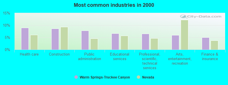
- Health care (8.9%)
- Construction (8.6%)
- Public administration (7.8%)
- Educational services (6.6%)
- Professional, scientific, technical services (6.5%)
- Arts, entertainment, recreation (5.9%)
- Finance & insurance (4.9%)
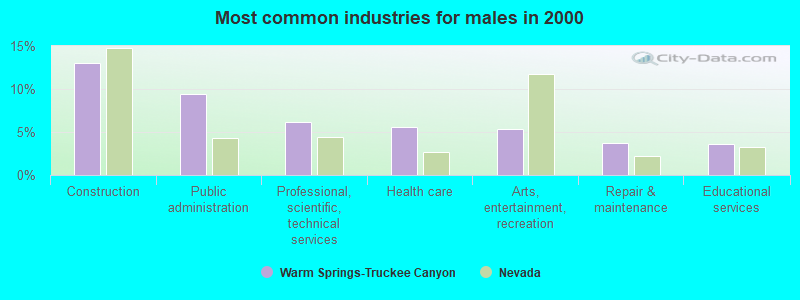
- Construction (13.1%)
- Public administration (9.5%)
- Professional, scientific, technical services (6.1%)
- Health care (5.5%)
- Arts, entertainment, recreation (5.4%)
- Repair & maintenance (3.7%)
- Educational services (3.6%)
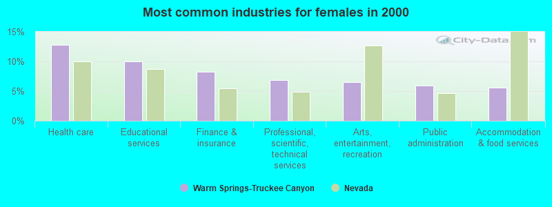
- Health care (12.8%)
- Educational services (10.0%)
- Finance & insurance (8.2%)
- Professional, scientific, technical services (6.8%)
- Arts, entertainment, recreation (6.6%)
- Public administration (5.9%)
- Accommodation & food services (5.6%)
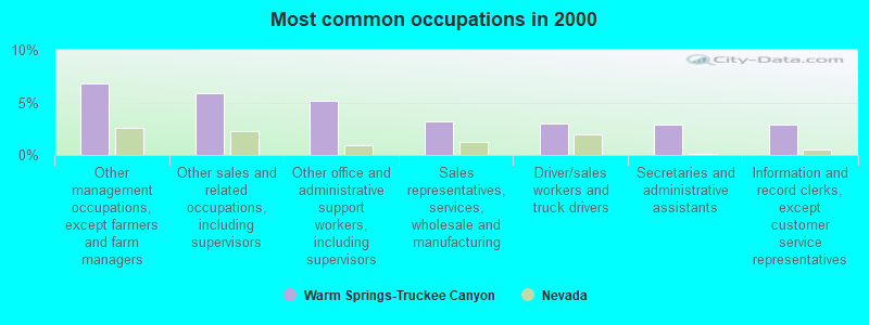
- Other management occupations, except farmers and farm managers (6.8%)
- Other sales and related occupations, including supervisors (5.9%)
- Other office and administrative support workers, including supervisors (5.1%)
- Sales representatives, services, wholesale and manufacturing (3.2%)
- Driver/sales workers and truck drivers (2.9%)
- Secretaries and administrative assistants (2.8%)
- Information and record clerks, except customer service representatives (2.8%)
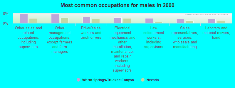
- Other sales and related occupations, including supervisors (7.7%)
- Other management occupations, except farmers and farm managers (7.5%)
- Driver/sales workers and truck drivers (5.4%)
- Electrical equipment mechanics and other installation, maintenance, and repair workers, including supervisors (4.9%)
- Law enforcement workers, including supervisors (4.2%)
- Sales representatives, services, wholesale and manufacturing (3.4%)
- Laborers and material movers, hand (3.4%)
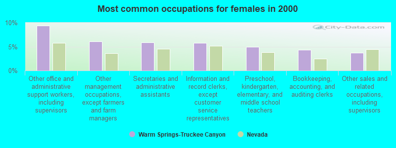
- Other office and administrative support workers, including supervisors (9.4%)
- Other management occupations, except farmers and farm managers (6.1%)
- Secretaries and administrative assistants (5.8%)
- Information and record clerks, except customer service representatives (5.8%)
- Preschool, kindergarten, elementary, and middle school teachers (4.9%)
- Bookkeeping, accounting, and auditing clerks (4.3%)
- Other sales and related occupations, including supervisors (3.7%)
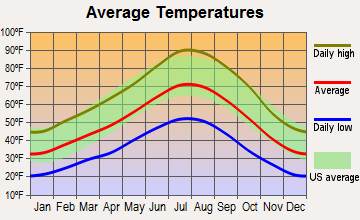
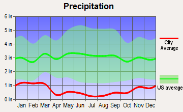
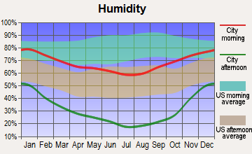
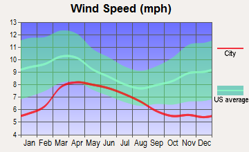
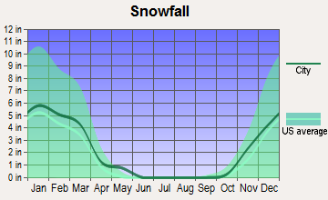
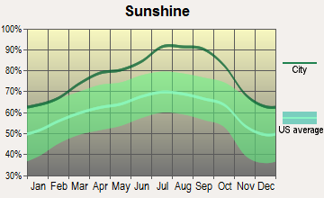
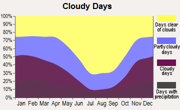
Average climate in Warm Springs-Truckee Canyon, Nevada
Based on data reported by over 4,000 weather stations
(lower is better)
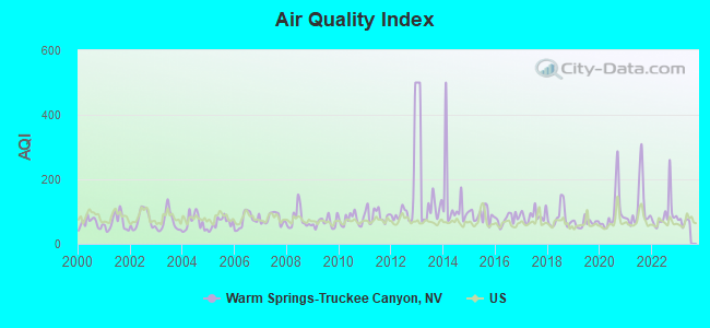
Air Quality Index (AQI) level in 2022 was 90.5. This is worse than average.
| City: | 90.5 |
| U.S.: | 72.6 |
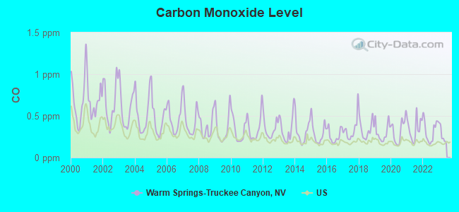
Carbon Monoxide (CO) [ppm] level in 2022 was 0.321. This is worse than average. Closest monitor was 10.3 miles away from the city center.
| City: | 0.321 |
| U.S.: | 0.251 |
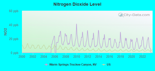
Nitrogen Dioxide (NO2) [ppb] level in 2022 was 11.8. This is significantly worse than average. Closest monitor was 11.9 miles away from the city center.
| City: | 11.8 |
| U.S.: | 5.1 |
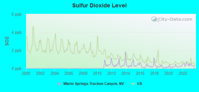
Sulfur Dioxide (SO2) [ppb] level in 2022 was 0.446. This is significantly better than average. Closest monitor was 12.7 miles away from the city center.
| City: | 0.446 |
| U.S.: | 1.515 |
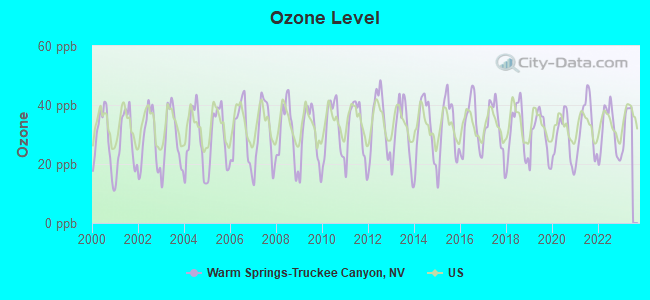
Ozone [ppb] level in 2022 was 30.9. This is about average. Closest monitor was 5.1 miles away from the city center.
| City: | 30.9 |
| U.S.: | 33.3 |
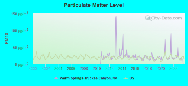
Particulate Matter (PM10) [µg/m3] level in 2022 was 21.3. This is about average. Closest monitor was 5.1 miles away from the city center.
| City: | 21.3 |
| U.S.: | 19.2 |
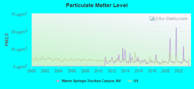
Particulate Matter (PM2.5) [µg/m3] level in 2022 was 8.15. This is about average. Closest monitor was 5.1 miles away from the city center.
| City: | 8.15 |
| U.S.: | 8.11 |
Earthquake activity:
Warm Springs-Truckee Canyon-area historical earthquake activity is significantly above Nevada state average. It is 6557% greater than the overall U.S. average.Natural disasters:
The number of natural disasters in Washoe County (28) is a lot greater than the US average (15).Major Disasters (Presidential) Declared: 4
Emergencies Declared: 3
Causes of natural disasters: Fires: 18, Floods: 6, Storms: 4, Mudslides: 2, Snows: 2, Winter Storms: 2, Hurricane: 1, Other: 1 (Note: some incidents may be assigned to more than one category).
Hospitals and medical centers near Warm Springs-Truckee Canyon:
- SPARKS DIALYSIS (DVA) (Dialysis Facility, about 7 miles away; SPARKS, NV)
- HEARTHSTONE OF NORTHERN NEVADA (Nursing Home, about 9 miles away; SPARKS, NV)
- WASHOE CARE CTR (Nursing Home, about 9 miles away; SPARKS, NV)
- NORTHERN NEVADA MEDICAL CENTER Acute Care Hospitals (about 10 miles away; SPARKS, NV)
- TAHOE PACIFIC HOSPITAL (Hospital, about 10 miles away; SPARKS, NV)
- RENOWN SKILLED NURSING (Nursing Home, about 11 miles away; SPARKS, NV)
- SIERRA HEALTH CARE CENTER ICF (Nursing Home, about 11 miles away; SPARKS, NV)
Amtrak stations near Warm Springs-Truckee Canyon:
- 11 miles: SPARKS (1100 NUGGET AVE.) . Services: fully wheelchair accessible, public payphones, call for car rental service, call for taxi service.
- 14 miles: RENO (135 E. COMMERCIAL ROW) . Services: ticket office, fully wheelchair accessible, enclosed waiting area, public restrooms, public payphones, call for car rental service, call for taxi service, public transit connection.
Colleges/universities with over 2000 students nearest to Warm Springs-Truckee Canyon:
- Truckee Meadows Community College (about 11 miles; Reno, NV; Full-time enrollment: 6,919)
- University of Nevada-Reno (about 13 miles; Reno, NV; FT enrollment: 15,092)
- Western Nevada College (about 35 miles; Carson City, NV; FT enrollment: 2,338)
- Sierra College (about 104 miles; Rocklin, CA; FT enrollment: 11,488)
- Folsom Lake College (about 106 miles; Folsom, CA; FT enrollment: 5,308)
- Butte College (about 107 miles; Oroville, CA; FT enrollment: 8,649)
- Yuba College (about 108 miles; Marysville, CA; FT enrollment: 4,737)
Points of interest:
Notable locations in Warm Springs-Truckee Canyon: Airway Beacon 212 (A), Hells Trap Shoot (B), Monte Cristo Ranch (C), Court of Antiquity (D), 102 Ranch (E), Gilpin Rest Stop (F), Winnemucca Ranch (G), Spanish Springs Ranch (H), Wilcox Ranch (I), NAA Weather Station (J), Blondell Ranch (K), Norton Mill (L), Harolds Trap Shooting Club (M), Peri Ranch (N), Stead Ranch (O), Jones Canyon Ranch (P), Wadsworth Volunteer Fire Department (Q), Palomino Valley Volunteer Fire Department Station 229 (R), Sparks Fire Department Station 4 (S), Reno Fire Department Station 17 (T). Display/hide their locations on the map
Reservoirs: Winnemucca Ranch Reservoir (A), Spanish Springs (B). Display/hide their locations on the map
Creeks: Big Mouth Creek (A), Paiute Creek (B), McClellans Creek (C), Millers Creek (D), Jones Creek (E), Cottonwood Creek (F). Display/hide their locations on the map
| This place: | 2.8 people |
| Nevada: | 2.6 people |
| This place: | 77.4% |
| Whole state: | 65.3% |
| This place: | 7.9% |
| Whole state: | 8.7% |
Likely homosexual households (counted as self-reported same-sex unmarried-partner households)
- Lesbian couples: 0.5% of all households
- Gay men: 0.4% of all households
| This place: | 3.3% |
| Whole state: | 10.5% |
| This place: | 1.6% |
| Whole state: | 4.9% |
People in group quarters in Warm Springs-Truckee Canyon in 2010:
- 57 people in group homes intended for adults
- 9 people in residential treatment centers for juveniles (non-correctional)
- 4 people in workers' group living quarters and job corps centers
People in group quarters in Warm Springs-Truckee Canyon in 2000:
- 44 people in nursing homes
- 12 people in unknown juvenile institutions
- 8 people in wards in general hospitals for patients who have no usual home elsewhere
For population 15 years and over in Warm Springs-Truckee Canyon:
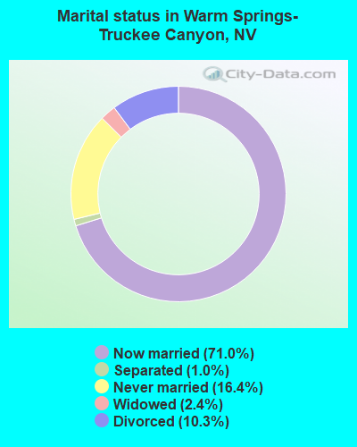
- Never married: 16.4%
- Now married: 71.0%
- Separated: 1.0%
- Widowed: 2.4%
- Divorced: 10.3%
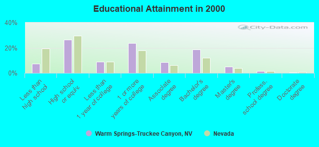
For population 25 years and over in Warm Springs-Truckee Canyon:
- High school or higher: 92.7%
- Bachelor's degree or higher: 25.4%
- Graduate or professional degree: 6.9%
- Unemployed: 2.6%
- Mean travel time to work (commute): 23.5 minutes
| Here: | 8.4 |
| Nevada average: | 11.9 |
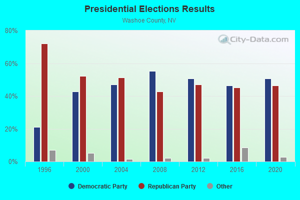
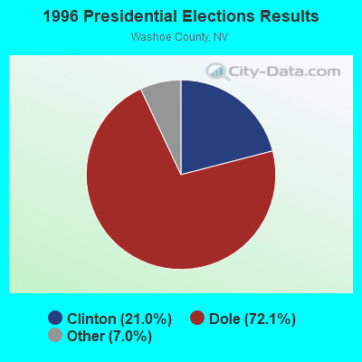
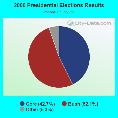
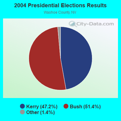
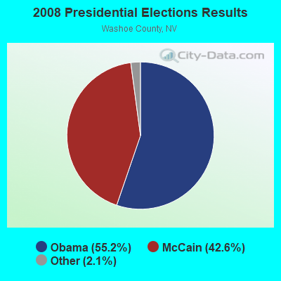
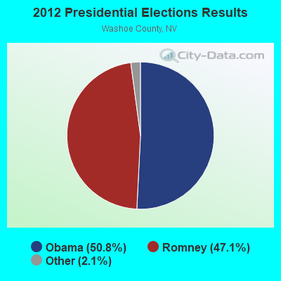
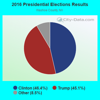
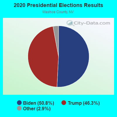
Graphs represent county-level data. Detailed 2008 Election Results
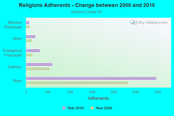
Religion statistics for Warm Springs-Truckee Canyon, NV (based on Washoe County data)
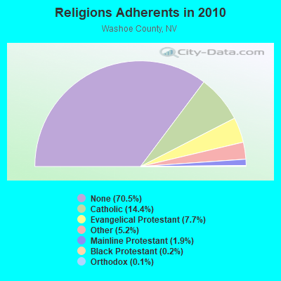
| Religion | Adherents | Congregations |
|---|---|---|
| Catholic | 60,509 | 13 |
| Evangelical Protestant | 32,557 | 109 |
| Other | 21,728 | 57 |
| Mainline Protestant | 8,194 | 28 |
| Black Protestant | 1,028 | 4 |
| Orthodox | 490 | 3 |
| None | 296,901 | - |
Food Environment Statistics:
| Washoe County: | 1.38 / 10,000 pop. |
| Nevada: | 1.50 / 10,000 pop. |
| This county: | 0.12 / 10,000 pop. |
| State: | 0.10 / 10,000 pop. |
| This county: | 0.99 / 10,000 pop. |
| State: | 1.00 / 10,000 pop. |
| Washoe County: | 2.69 / 10,000 pop. |
| Nevada: | 2.56 / 10,000 pop. |
| Washoe County: | 6.99 / 10,000 pop. |
| Nevada: | 6.14 / 10,000 pop. |
| Washoe County: | 6.5% |
| Nevada: | 8.2% |
| This county: | 21.2% |
| Nevada: | 24.5% |
| This county: | 14.3% |
| State: | 13.2% |
6.72% of this county's 2021 resident taxpayers lived in other counties in 2020 ($145,713 average adjusted gross income)
| Here: | 6.72% |
| Nevada average: | 6.67% |
0.01% of residents moved from foreign countries ($163 average AGI)
Washoe County: 0.01% Nevada average: 0.05%
Top counties from which taxpayers relocated into this county between 2020 and 2021:
| from Clark County, NV | |
| from Lyon County, NV | |
| from Los Angeles County, CA |
6.06% of this county's 2020 resident taxpayers moved to other counties in 2021 ($85,171 average adjusted gross income)
| Here: | 6.06% |
| Nevada average: | 5.77% |
0.01% of residents moved to foreign countries ($110 average AGI)
Washoe County: 0.01% Nevada average: 0.04%
Top counties to which taxpayers relocated from this county between 2020 and 2021:
| to Clark County, NV | |
| to Lyon County, NV | |
| to Carson City, NV |
Strongest AM radio stations in Warm Springs-Truckee Canyon:
- KKOH (780 AM; 50 kW; RENO, NV; Owner: CITADEL BROADCASTING COMPANY)
- KBZZ (1270 AM; 13 kW; SPARKS, NV; Owner: AMERICOM LAS VEGAS LIMITED PARTNERSHIP)
- KPTT (630 AM; 5 kW; RENO, NV; Owner: LOTUS RADIO CORP.)
- KIHM (920 AM; 5 kW; RENO, NV; Owner: IHR EDUCATIONAL BROADCASTING)
- KXTO (1550 AM; 2 kW; RENO, NV; Owner: FIRST BROADCASTING OF NEVADA, INC.)
- KQLO (1590 AM; 5 kW; SUN VALLEY, NV; Owner: THOMAS AQUINAS SCHOOL)
- KBDB (1400 AM; 1 kW; SPARKS, NV; Owner: GEORGE S. FLINN, JR.)
- KXEQ (1340 AM; 1 kW; RENO, NV; Owner: AZTECA BROADCASTING CORPORATION)
- KPLY (1230 AM; 1 kW; RENO, NV; Owner: AMERICOM LAS VEGAS LIMITED PARTNERSHIP)
- KHIT (1450 AM; 1 kW; RENO, NV; Owner: LOTUS RADIO CORP.)
- KPTL (1300 AM; 5 kW; CARSON CITY, NV; Owner: CASINO RADIO, LLC)
- KHTK (1140 AM; 50 kW; SACRAMENTO, CA; Owner: INFINITY RADIO SUBSIDIARY OPERATIONS INC.)
- KFIA (710 AM; 25 kW; CARMICHAEL, CA; Owner: VISTA BROADCASTING INC.)
Strongest FM radio stations in Warm Springs-Truckee Canyon:
- KNHK (92.9 FM; RENO, NV; Owner: CITADEL BROADCASTING COMPANY)
- KRNG-FM1 (101.3 FM; RENO, NV; Owner: SIERRA NV CHRISTIAN MUSIC ASSN INC)
- KHXR (94.5 FM; SUN VALLEY, NV; Owner: LOTUS RADIO CORP.)
- KSRN (107.7 FM; KINGS BEACH, CA; Owner: NM LICENSING, LLC)
- K285EQ (104.9 FM; VERDI, NV; Owner: AMERICOM, A CALIFORNIA LIMITED PARTNERSHIP)
- KJZS (92.1 FM; SPARKS, NV; Owner: NM LICENSING, LLC)
- KLCA (96.5 FM; TAHOE CITY, CA; Owner: AMERICOM LAS VEGAS LIMITED PARTNERSHIP)
- KRNO (106.9 FM; INCLINE VILLAGE, NV; Owner: AMERICOM LAS VEGAS LIMITED PARTNERSHIP)
- KODS (103.7 FM; CARNELIAN BAY, CA; Owner: AMERICOM, A CALIFORNIA LIMITED PARTNERSHIP)
- KDOT (104.5 FM; RENO, NV; Owner: LOTUS RADIO CORP.)
- KOZZ-FM (105.7 FM; RENO, NV; Owner: LOTUS RADIO CORP.)
- KKTO (90.5 FM; TAHOE CITY, CA; Owner: CALIFORNIA STATE UNIVERSITY)
- KTHX-FM (100.1 FM; DAYTON, NV; Owner: NM LICENSING, LLC)
- KRNG (101.3 FM; FALLON, NV; Owner: SIERRA NV CHRISTIAN MUSIC ASSOC, INC)
- KBUL-FM (98.1 FM; CARSON CITY, NV; Owner: CITADEL BROADCASTING COMPANY)
- KNEV (95.5 FM; RENO, NV; Owner: CITADEL BROADCASTING COMPANY)
- KUNR (88.7 FM; RENO, NV; Owner: UNIVERSITY OF NEVADA, RENO)
- KNIS (91.3 FM; CARSON CITY, NV; Owner: WESTERN INSPIRATIONAL BROADCASTERS, INC)
- KWNZ (97.3 FM; CARSON CITY, NV; Owner: AMERICOM LAS VEGAS LIMITED PARTNERSHIP)
- KSSJ (94.7 FM; FAIR OAKS, CA; Owner: ENTERCOM SACRAMENTO LICENSE, LLC)
TV broadcast stations around Warm Springs-Truckee Canyon:
- KNPB (Channel 5; RENO, NV; Owner: CHANNEL 5 PUBLIC BROADCASTING, INC.)
- KRNV (Channel 4; RENO, NV; Owner: SIERRA BROADCASTING COMPANY)
- KRXI-TV (Channel 11; RENO, NV; Owner: KTVU PARTNERSHIP)
- K52FF (Channel 52; RENO, NV; Owner: TELEMUNDO OF NORTHERN CALIFORNIA LICENSE CORP.)
- KRRI-LP (Channel 25; RENO, NV; Owner: EQUITY BROADCASTING CORPORATION)
- KAME-TV (Channel 21; RENO, NV; Owner: BROADCAST DEVELOPMENT CORPORATION)
- KUVR-CA (Channel 68; RENO, ETC., NV; Owner: RENO LICENSE, LLC)
- KELM-LP (Channel 43; RENO, NV; Owner: TIGER EYE BROADCASTING CORPORATION)
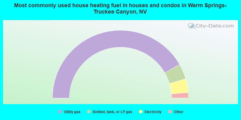
- 83.5%Utility gas
- 7.3%Bottled, tank, or LP gas
- 6.6%Electricity
- 1.2%Wood
- 0.9%Fuel oil, kerosene, etc.
- 0.3%Other fuel
- 0.2%Solar energy
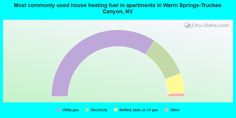
- 68.5%Utility gas
- 20.4%Electricity
- 9.5%Bottled, tank, or LP gas
- 1.2%Fuel oil, kerosene, etc.
- 0.4%Other fuel
Warm Springs-Truckee Canyon compared to Nevada state average:
- Median household income above state average.
- Unemployed percentage significantly below state average.
- Black race population percentage significantly below state average.
- Hispanic race population percentage significantly below state average.
- Median age below state average.
- Foreign-born population percentage significantly below state average.
- Renting percentage below state average.
- Length of stay since moving in significantly above state average.
- Number of rooms per house significantly below state average.
- House age significantly below state average.
Warm Springs-Truckee Canyon on our top lists:
- #13 on the list of "Top 101 cities with largest percentage of females in industries: electrical and electronic goods merchant wholesalers (population 5,000+)"
- #19 on the list of "Top 101 cities with largest percentage of males in industries: hardware, plumbing and heating equipment, and supplies merchant wholesalers (population 5,000+)"
- #29 on the list of "Top 101 cities with largest percentage of males in occupations: other sales and related workers including supervisors (population 5,000+)"
- #32 on the list of "Top 101 cities with largest percentage of males in industries: alcoholic beverages merchant wholesalers (population 5,000+)"
- #44 on the list of "Top 101 cities with largest percentage of females in occupations: entertainers and performers, sports, and related workers (population 5,000+)"
- #49 on the list of "Top 101 cities with largest percentage of males in occupations: supervisors and other personal care and service workers except personal appearance, transportation, and child care workers (population 5,000+)"
- #71 on the list of "Top 101 cities with largest percentage of females in industries: alcoholic beverages merchant wholesalers (population 5,000+)"
- #74 on the list of "Top 101 cities with largest percentage of females in occupations: other office and administrative support workers including supervisors (population 5,000+)"
- #76 on the list of "Top 101 cities with largest percentage of females in industries: rail transportation (population 5,000+)"
- #81 on the list of "Top 101 cities with largest percentage of females in industries: air transportation (population 5,000+)"
- #85 on the list of "Top 101 cities with largest percentage of males in industries: warehousing and storage (population 5,000+)"
- #88 on the list of "Top 101 cities with largest percentage of females in occupations: other management occupations except farmers and farm managers (population 5,000+)"
- #91 on the list of "Top 101 cities with largest percentage of females in industries: motor vehicles, parts and supplies merchant wholesalers (population 5,000+)"
- #92 on the list of "Top 101 cities with largest percentage of females in industries: petroleum and coal products (population 5,000+)"
- #94 on the list of "Top 101 cities with largest percentage of females in occupations: information and record clerks except customer service representatives (population 5,000+)"
- #100 on the list of "Top 100 cities with largest land areas (pop. 5,000+)"
- #6 on the list of "Top 101 counties with the largest increase in the number of infant deaths per 1000 residents 2000-2006 to 2007-2013 (pop. 50,000+)"
- #27 on the list of "Top 101 counties with the lowest Sulfur Oxides Annual air pollution readings in 2012 (µg/m3)"
- #57 on the list of "Top 101 counties with the highest percentage of residents that exercised in the past month"
- #59 on the list of "Top 101 counties with the highest percentage of residents that keep firearms around their homes"
- #70 on the list of "Top 101 counties with the highest Nitrogen Dioxide air pollution readings in 2012 (ppm)"