Uintah and Ouray, Utah
Submit your own pictures of this place and show them to the world
- OSM Map
- General Map
- Google Map
- MSN Map

| Males: 1 | |
| Females: 1 |
| Median resident age: | 44.5 years |
| Utah median age: | 27.1 years |
Median resident age: 44.5 years
Zip code: 84027
Uintah and Ouray, UT residents, houses, and apartments details


- 150.0%White alone
- 150.0%Two or more races

 Recent articles from our blog. Our writers, many of them Ph.D. graduates or candidates, create easy-to-read articles on a wide variety of topics.
Current Local Time: MST time zone
Land area: 315.6 square miles.
Population density: 0.01 people per square mile (very low).

Nearest city with pop. 50,000+: Provo, UT  (115.8 miles , pop. 105,166).
Nearest city with pop. 200,000+: Northeast Jefferson, CO (253.1 miles , pop. 450,166).
Nearest city with pop. 1,000,000+: Phoenix, AZ (421.2 miles , pop. 1,321,045).
Nearest cities:
), ), ), Latitude: 39.34 N, Longitude: 109.82 W
Area code commonly used in this area: 435

| Here: | 5.4% |
| Utah: | 2.5% |
Average climate in Uintah and Ouray, Utah
Based on data reported by over 4,000 weather stations


Earthquake activity:
Uintah and Ouray-area historical earthquake activity is significantly above Utah state average. It is 1949% greater than the overall U.S. average.On 8/18/1959 at 06:37:13, a magnitude 7.7 (7.7 UK, Class: Major, Intensity: VIII - XII) earthquake occurred 363.8 miles away from the city center, causing $26,000,000 total damage
On 10/3/1915 at 06:52:48, a magnitude 7.6 (7.6 UK) earthquake occurred 414.8 miles away from the city center
On 10/28/1983 at 14:06:06, a magnitude 7.3 (6.2 MB, 7.3 MS, 7.0 MW) earthquake occurred 386.4 miles away from Uintah and Ouray center, causing 2 deaths (2 shaking deaths) and 3 injuries, causing $15,000,000 total damage
On 3/28/1975 at 02:31:05, a magnitude 6.2 (6.1 MB, 6.0 MS, 6.2 ML, Class: Strong, Intensity: VII - IX) earthquake occurred 231.1 miles away from the city center
On 6/28/1992 at 11:57:34, a magnitude 7.6 (6.2 MB, 7.6 MS, 7.3 MW, Depth: 0.7 mi) earthquake occurred 515.0 miles away from Uintah and Ouray center, causing 3 deaths (1 shaking deaths, 2 other deaths) and 400 injuries, causing $100,000,000 total damage and $40,000,000 insured losses
On 3/18/2020 at 13:09:31, a magnitude 5.7 (5.7 MW, Depth: 7.4 mi, Class: Moderate, Intensity: VI - VII) earthquake occurred 154.0 miles away from Uintah and Ouray center
Magnitude types: body-wave magnitude (MB), local magnitude (ML), surface-wave magnitude (MS), moment magnitude (MW)
Natural disasters:
The number of natural disasters in Grand County (3) is a lot smaller than the US average (15).Emergencies Declared: 2
Causes of natural disasters: Drought: 1, Hurricane: 1, Other: 1 (Note: some incidents may be assigned to more than one category).
Colleges/universities with over 2000 students nearest to Uintah and Ouray:
- Colorado Mesa University (about 72 miles; Grand Junction, CO; Full-time enrollment: 7,671)
- Snow College (about 94 miles; Ephraim, UT; FT enrollment: 3,224)
- Brigham Young University-Provo (about 116 miles; Provo, UT; FT enrollment: 33,525)
- Utah Valley University (about 120 miles; Orem, UT; FT enrollment: 24,403)
- Colorado Mountain College (about 135 miles; Glenwood Springs, CO; FT enrollment: 3,463)
- Western Governors University (about 143 miles; Salt Lake City, UT; FT enrollment: 31,481)
- Stevens-Henager College-Murray (about 143 miles; Murray, UT; FT enrollment: 6,395)
Points of interest:
Notable locations in Uintah and Ouray: Hill Creek Ranger Station (A), Hill Creek Youth Camp (B), McPherson Ranch (C), Stevens Cabin (D). Display/hide their locations on the map
Reservoir: Weaver Reservoir (A). Display/hide its location on the map
Streams, rivers, and creeks: Pioche Creek (A), Spring Creek (B), Harris Fork (C), Florence Creek (D), West Fork Hill Creek (E), Coal Creek (F), Chicken Fork (G), Bluebell Creek (H), Joe Hutch Creek (I). Display/hide their locations on the map
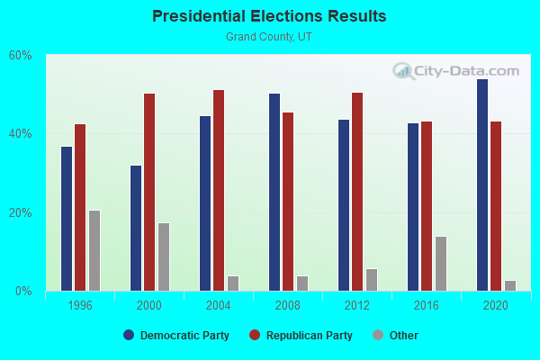
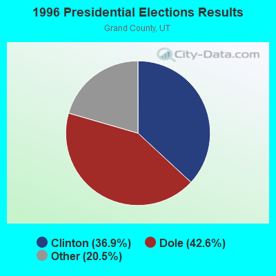
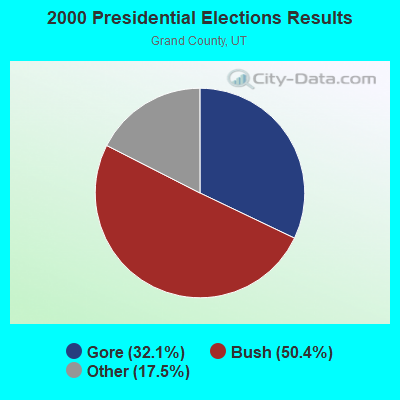
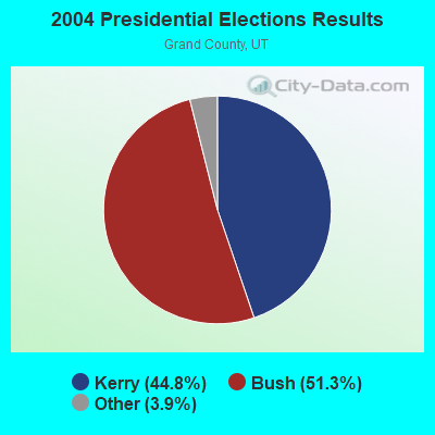
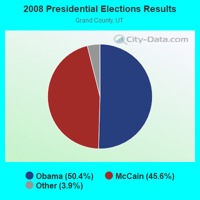
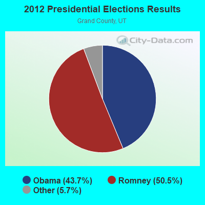
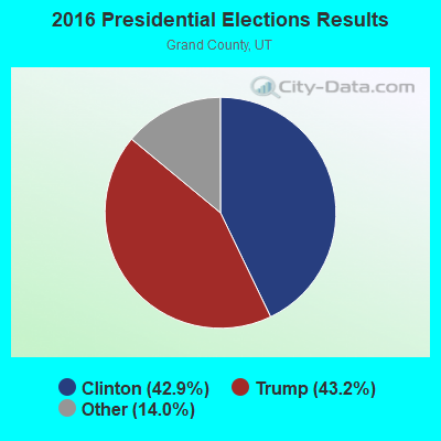
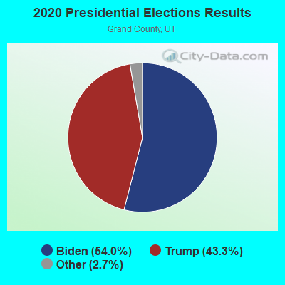
Graphs represent county-level data. Detailed 2008 Election Results
Religion statistics for Uintah and Ouray, UT (based on Grand County data)
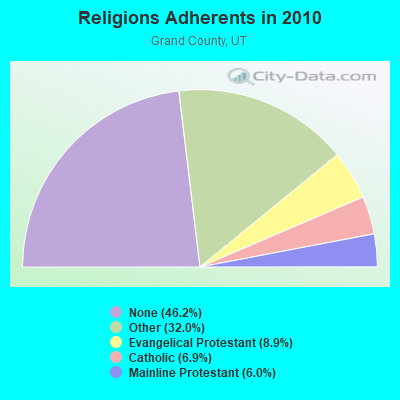
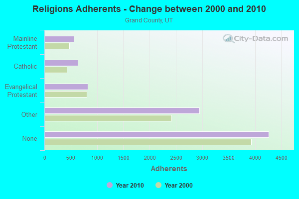
| Religion | Adherents | Congregations |
|---|---|---|
| Other | 2,948 | 10 |
| Evangelical Protestant | 823 | 7 |
| Catholic | 635 | 1 |
| Mainline Protestant | 555 | 4 |
| None | 4,264 | - |
Food Environment Statistics:
| This county: | 2.12 / 10,000 pop. |
| Utah: | 1.37 / 10,000 pop. |
| This county: | 1.06 / 10,000 pop. |
| Utah: | 0.41 / 10,000 pop. |
| This county: | 3.18 / 10,000 pop. |
| Utah: | 2.82 / 10,000 pop. |
| Here: | 26.53 / 10,000 pop. |
| Utah: | 5.09 / 10,000 pop. |
| This county: | 7.7% |
| Utah: | 6.3% |
| Grand County: | 19.7% |
| Utah: | 23.6% |
Strongest AM radio stations in Uintah and Ouray:
- KNZZ (1100 AM; 50 kW; GRAND JUNCTION, CO; Owner: M B C GRAND BROADCASTING, INC.)
- KOAL (750 AM; 10 kW; PRICE, UT; Owner: EASTERN UTAH BROADCASTING CO.)
- KJOL (620 AM; 10 kW; GRAND JUNCTION, CO; Owner: UNITED MINISTRIES)
- KSLL (1080 AM; daytime; 10 kW; PRICE, UT; Owner: AGAINST THE WIND BROADCASTING, INC.)
- KALL (700 AM; 50 kW; NORTH SALT LAKE CITY, UT; Owner: CITICASTERS LICENSES, L.P.)
- KIQN (1010 AM; 50 kW; TOOELE, UT)
- KSL (1160 AM; 50 kW; SALT LAKE CITY, UT; Owner: BONNEVILLE HOLDING COMPANY)
- KMTI (650 AM; 10 kW; MANTI, UT; Owner: SANPETE COUNTY BROADCASTING COMPANY)
- KTNN (660 AM; 50 kW; WINDOW ROCK, AZ; Owner: THE NAVAJO NATION)
- KLTT (670 AM; 50 kW; COMMERCE CITY, CO; Owner: KLZ RADIO, INC.)
- KNEU (1250 AM; 5 kW; ROOSEVELT, UT; Owner: COUNTRY GOLD BROADCASTING, INC.)
- KKZN (760 AM; 50 kW; THORNTON, CO; Owner: JACOR BROADCASTING OF COLORADO, INC.)
- KVEL (920 AM; 5 kW; VERNAL, UT; Owner: ASHLEY COMMUNICATIONS, INC.)
Strongest FM radio stations in Uintah and Ouray:
- K220ET (91.9 FM; PRICE, UT; Owner: EDUCATIONAL MEDIA FOUNDATION)
Uintah and Ouray compared to Utah state average:
- Median household income significantly below state average.
- Median house value significantly below state average.
- Unemployed percentage significantly below state average.
- Black race population percentage significantly below state average.
- Hispanic race population percentage significantly below state average.
- Median age significantly above state average.
- Foreign-born population percentage significantly below state average.
- Renting percentage significantly below state average.
- Length of stay since moving in significantly above state average.
- Number of rooms per house significantly below state average.
- House age significantly below state average.
- Number of college students significantly below state average.
- Percentage of population with a bachelor's degree or higher significantly below state average.