Thompson, Utah
Submit your own pictures of this place and show them to the world
- OSM Map
- General Map
- Google Map
- MSN Map

| Males: 180 | |
| Females: 180 |
| Median resident age: | 38.1 years |
| Utah median age: | 27.1 years |
Zip code: 84540
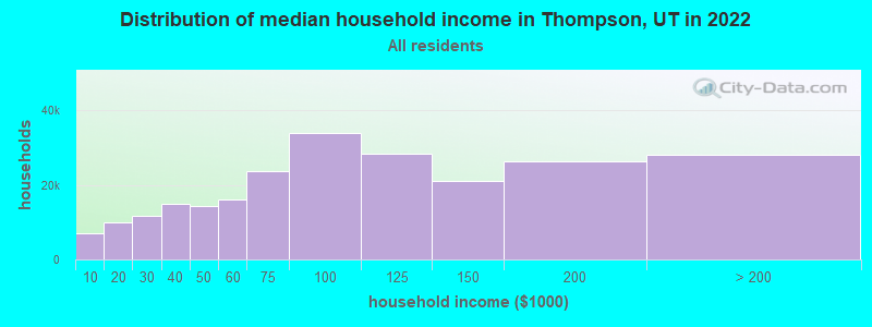
| Thompson: | $35,729 |
| UT: | $89,168 |
Estimated per capita income in 2022: $26,071 (it was $11,596 in 2000)
Thompson CCD income, earnings, and wages data
Estimated median house or condo value in 2022: $457,707 (it was $91,300 in 2000)
| Thompson: | $457,707 |
| UT: | $499,500 |
Mean prices in 2022: all housing units: $589,529; detached houses: $662,670; townhouses or other attached units: $505,712; mobile homes: $191,339
Detailed information about poverty and poor residents in Thompson, UT


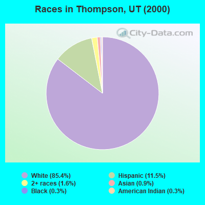
- 27485.4%White alone
- 3711.5%Hispanic
- 51.6%Two or more races
- 30.9%Asian alone
- 10.3%Black alone
- 10.3%American Indian alone
Races in Thompson detailed stats: ancestries, foreign born residents, place of birth
According to our research of Utah and other state lists, there was 1 registered sex offender living in Thompson, Utah as of May 01, 2024.
The ratio of all residents to sex offenders in Thompson is 360 to 1.
The ratio of registered sex offenders to all residents in this city is near the state average.
 Recent articles from our blog. Our writers, many of them Ph.D. graduates or candidates, create easy-to-read articles on a wide variety of topics.
Current Local Time: MST time zone
Land area: 2740.4 square miles.
Population density: 0.1 people per square mile (very low).

| Thompson CCD: | 0.4% ($357) |
| Utah: | 0.7% ($956) |
Nearest city with pop. 50,000+: Provo, UT  (141.6 miles , pop. 105,166).
Nearest city with pop. 200,000+: Northeast Jefferson, CO (246.2 miles , pop. 450,166).
Nearest city with pop. 1,000,000+: Phoenix, AZ (400.0 miles , pop. 1,321,045).
Nearest cities:
), ), )Latitude: 38.96 N, Longitude: 109.60 W
Area code: 435

| Here: | 5.4% |
| Utah: | 2.5% |
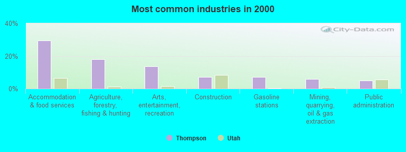
- Accommodation & food services (29.5%)
- Agriculture, forestry, fishing & hunting (18.0%)
- Arts, entertainment, recreation (13.7%)
- Construction (7.2%)
- Gasoline stations (7.2%)
- Mining, quarrying, oil & gas extraction (5.8%)
- Public administration (5.0%)

- Agriculture, forestry, fishing & hunting (29.3%)
- Accommodation & food services (23.2%)
- Arts, entertainment, recreation (18.3%)
- Mining, quarrying, oil & gas extraction (9.8%)
- Gasoline stations (4.9%)
- Used merchandise, gift, novelty, souvenir, other miscellaneous stores (4.9%)
- Motor vehicle & parts dealers (3.7%)
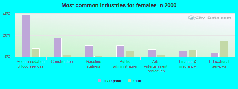
- Accommodation & food services (38.6%)
- Construction (17.5%)
- Gasoline stations (10.5%)
- Public administration (10.5%)
- Arts, entertainment, recreation (7.0%)
- Finance & insurance (5.3%)
- Educational services (3.5%)
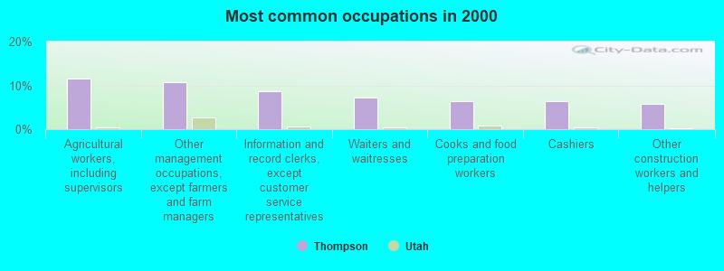
- Agricultural workers, including supervisors (11.5%)
- Other management occupations, except farmers and farm managers (10.8%)
- Information and record clerks, except customer service representatives (8.6%)
- Waiters and waitresses (7.2%)
- Cooks and food preparation workers (6.5%)
- Cashiers (6.5%)
- Other construction workers and helpers (5.8%)
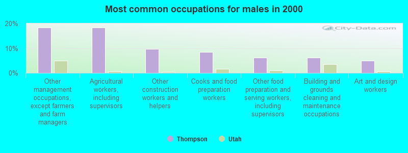
- Other management occupations, except farmers and farm managers (18.3%)
- Agricultural workers, including supervisors (18.3%)
- Other construction workers and helpers (9.8%)
- Cooks and food preparation workers (8.5%)
- Other food preparation and serving workers, including supervisors (6.1%)
- Building and grounds cleaning and maintenance occupations (6.1%)
- Art and design workers (4.9%)
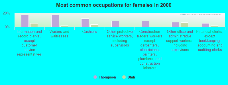
- Information and record clerks, except customer service representatives (17.5%)
- Waiters and waitresses (17.5%)
- Cashiers (12.3%)
- Other protective service workers, including supervisors (8.8%)
- Construction traders workers except carpenters, electricians, painters, plumbers, and construction laborers (8.8%)
- Other office and administrative support workers, including supervisors (7.0%)
- Financial clerks, except bookkeeping, accounting and auditing clerks (5.3%)
Average climate in Thompson, Utah
Based on data reported by over 4,000 weather stations


Earthquake activity:
Thompson-area historical earthquake activity is significantly above Utah state average. It is 1862% greater than the overall U.S. average.On 8/18/1959 at 06:37:13, a magnitude 7.7 (7.7 UK, Class: Major, Intensity: VIII - XII) earthquake occurred 391.9 miles away from the city center, causing $26,000,000 total damage
On 10/3/1915 at 06:52:48, a magnitude 7.6 (7.6 UK) earthquake occurred 433.6 miles away from Thompson center
On 10/28/1983 at 14:06:06, a magnitude 7.3 (6.2 MB, 7.3 MS, 7.0 MW) earthquake occurred 415.7 miles away from Thompson center, causing 2 deaths (2 shaking deaths) and 3 injuries, causing $15,000,000 total damage
On 6/28/1992 at 11:57:34, a magnitude 7.6 (6.2 MB, 7.6 MS, 7.3 MW, Depth: 0.7 mi) earthquake occurred 507.1 miles away from the city center, causing 3 deaths (1 shaking deaths, 2 other deaths) and 400 injuries, causing $100,000,000 total damage and $40,000,000 insured losses
On 3/28/1975 at 02:31:05, a magnitude 6.2 (6.1 MB, 6.0 MS, 6.2 ML, Class: Strong, Intensity: VII - IX) earthquake occurred 260.0 miles away from Thompson center
On 10/16/1999 at 09:46:44, a magnitude 7.4 (6.3 MB, 7.4 MS, 7.2 MW, 7.3 ML) earthquake occurred 487.7 miles away from the city center
Magnitude types: body-wave magnitude (MB), local magnitude (ML), surface-wave magnitude (MS), moment magnitude (MW)
Natural disasters:
The number of natural disasters in Grand County (3) is a lot smaller than the US average (15).Emergencies Declared: 2
Causes of natural disasters: Drought: 1, Hurricane: 1, Other: 1 (Note: some incidents may be assigned to more than one category).
Colleges/universities with over 2000 students nearest to Thompson:
- Colorado Mesa University (about 58 miles; Grand Junction, CO; Full-time enrollment: 7,671)
- Snow College (about 111 miles; Ephraim, UT; FT enrollment: 3,224)
- Colorado Mountain College (about 129 miles; Glenwood Springs, CO; FT enrollment: 3,463)
- Brigham Young University-Provo (about 142 miles; Provo, UT; FT enrollment: 33,525)
- Utah Valley University (about 146 miles; Orem, UT; FT enrollment: 24,403)
- Western State Colorado University (about 148 miles; Gunnison, CO; FT enrollment: 2,023)
- Fort Lewis College (about 150 miles; Durango, CO; FT enrollment: 3,631)
Points of interest:
Notable locations in Thompson: Gavin Ranch (A), Arches National Park Visitor Center (B), Atlas Mineral Plant (C), Gordon Ranch (D), Hallet Ranch (E), Harley Dome (F), Hatch Ranch (G), Daly (H), Delicate Arch Viewpoint (I), Devils Garden Campground (J), Devils Garden Trailhead (K), Emkay (L), Fiery Furnace Viewpoint (M), La Sal Mountains Viewpoint (N), North Park Avenue Trailhead (O), Panorama Point (P), Potash (Q), Salt Valley Overlook (R), South Park Avenue Trailhead (S), Westwater River Ranger Station and Put In Site (T). Display/hide their locations on the map
Cemeteries: Thompson Cemetery (1), Elgin Cemetery (2), Sego Cemetery (3). Display/hide their locations on the map
Lakes and reservoirs: Holding Pond (A), Twin Pond (B), Tie Pond (C), Dead Sheep Pond (D), Strychnine Pond (E), Rock Corral Reservoir (F), Valley City Reservoir (G), Big Flat Reservoir (H). Display/hide their locations on the map
Streams, rivers, and creeks: Sulphur Creek (A), Potato Creek (B), Tenmile Wash (C), Thompson Wash (D), Fish Creek (E), East Willow Creek (F), West Willow Creek (G), Clear Creek (H), Little Creek (I). Display/hide their locations on the map
Parks in Thompson include: Arches National Park (1), Dead Horse Point State Park (2). Display/hide their locations on the map
Drinking water stations with addresses in Thompson and their reported violations in the past:
THOMPSON SPECIAL SERVICES DISTRICT (Population served: 39, Groundwater):Past monitoring violations:
- Monitoring and Reporting (DBP) - Between OCT-2013 and DEC-2013, Contaminant: Chlorine. Follow-up actions: St Formal NOV issued (JAN-19-2014), St Public Notif requested (JAN-19-2014)
- Monitoring and Reporting (DBP) - Between JUL-2013 and SEP-2013, Contaminant: Chlorine. Follow-up actions: St Formal NOV issued (OCT-12-2013), St Public Notif requested (OCT-12-2013)
- Monitoring and Reporting (DBP) - Between APR-2013 and JUN-2013, Contaminant: Chlorine. Follow-up actions: St Formal NOV issued (OCT-12-2013), St Public Notif requested (OCT-12-2013)
- Monitoring and Reporting (DBP) - Between JAN-2013 and MAR-2013, Contaminant: Chlorine. Follow-up actions: St Formal NOV issued (OCT-12-2013), St Public Notif requested (OCT-12-2013)
- Monitoring and Reporting (DBP) - Between OCT-2011 and DEC-2011, Contaminant: Chlorine. Follow-up actions: St Formal NOV issued (FEB-18-2012), St Public Notif requested (FEB-18-2012)
- 21 routine major monitoring violations
- 19 regular monitoring violations
- 5 other older monitoring violations
| This place: | 2.2 people |
| Utah: | 3.1 people |
| This place: | 46.2% |
| Whole state: | 77.0% |
| This place: | 3.4% |
| Whole state: | 3.4% |
Likely homosexual households (counted as self-reported same-sex unmarried-partner households)
- Lesbian couples: 0.7% of all households
- Gay men: 0.0% of all households
| This place: | 27.8% |
| Whole state: | 9.4% |
| This place: | 11.4% |
| Whole state: | 3.9% |
For population 15 years and over in Thompson:
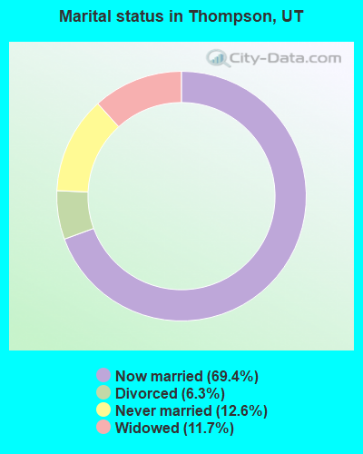
- Never married: 12.6%
- Now married: 69.4%
- Separated: 0.0%
- Widowed: 11.7%
- Divorced: 6.3%
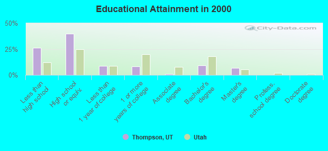
For population 25 years and over in Thompson:
- High school or higher: 74.0%
- Bachelor's degree or higher: 16.2%
- Graduate or professional degree: 6.9%
- Unemployed: 4.8%
- Mean travel time to work (commute): 13.9 minutes
| Here: | 11.6 |
| Utah average: | 10.5 |
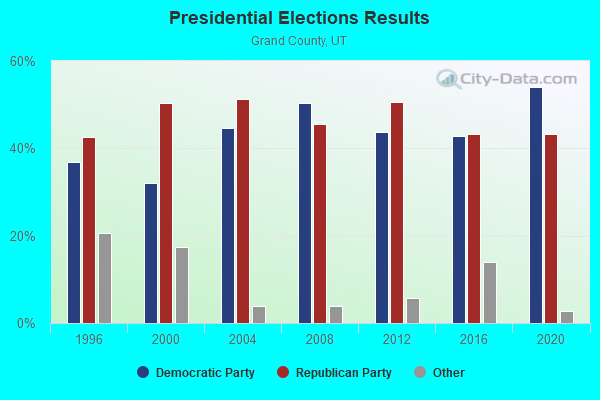
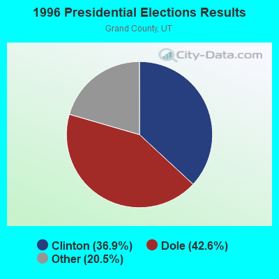
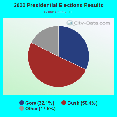
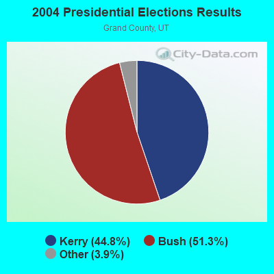
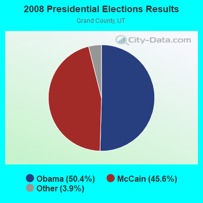
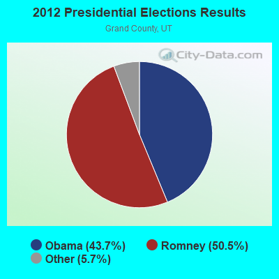
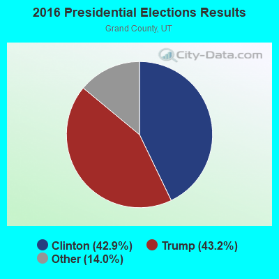
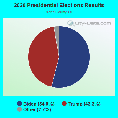
Graphs represent county-level data. Detailed 2008 Election Results
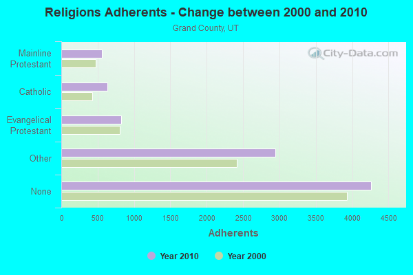
Religion statistics for Thompson, UT (based on Grand County data)
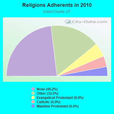
| Religion | Adherents | Congregations |
|---|---|---|
| Other | 2,948 | 10 |
| Evangelical Protestant | 823 | 7 |
| Catholic | 635 | 1 |
| Mainline Protestant | 555 | 4 |
| None | 4,264 | - |
Food Environment Statistics:
| Grand County: | 2.12 / 10,000 pop. |
| Utah: | 1.37 / 10,000 pop. |
| Here: | 1.06 / 10,000 pop. |
| Utah: | 0.41 / 10,000 pop. |
| Here: | 3.18 / 10,000 pop. |
| Utah: | 2.82 / 10,000 pop. |
| Here: | 26.53 / 10,000 pop. |
| Utah: | 5.09 / 10,000 pop. |
| Here: | 7.7% |
| Utah: | 6.3% |
| This county: | 19.7% |
| Utah: | 23.6% |
Strongest AM radio stations in Thompson:
- KNZZ (1100 AM; 50 kW; GRAND JUNCTION, CO; Owner: M B C GRAND BROADCASTING, INC.)
- KJOL (620 AM; 10 kW; GRAND JUNCTION, CO; Owner: UNITED MINISTRIES)
- KOAL (750 AM; 10 kW; PRICE, UT; Owner: EASTERN UTAH BROADCASTING CO.)
- KALL (700 AM; 50 kW; NORTH SALT LAKE CITY, UT; Owner: CITICASTERS LICENSES, L.P.)
- KSLL (1080 AM; daytime; 10 kW; PRICE, UT; Owner: AGAINST THE WIND BROADCASTING, INC.)
- KTNN (660 AM; 50 kW; WINDOW ROCK, AZ; Owner: THE NAVAJO NATION)
- KIQN (1010 AM; 50 kW; TOOELE, UT)
- KSL (1160 AM; 50 kW; SALT LAKE CITY, UT; Owner: BONNEVILLE HOLDING COMPANY)
- KMTI (650 AM; 10 kW; MANTI, UT; Owner: SANPETE COUNTY BROADCASTING COMPANY)
- KLTT (670 AM; 50 kW; COMMERCE CITY, CO; Owner: KLZ RADIO, INC.)
- KKZN (760 AM; 50 kW; THORNTON, CO; Owner: JACOR BROADCASTING OF COLORADO, INC.)
- KHAC (880 AM; 43 kW; TSE BONITO, NM; Owner: WESTERN INDIAN MINISTRIES, INC.)
- KOA (850 AM; 50 kW; DENVER, CO; Owner: JACOR BROADCASTING OF COLORADO, INC.)
Strongest FM radio stations in Thompson:
- KCYN (97.1 FM; MOAB, UT; Owner: MOAB COMMUNICATIONS, LLC)
- K291AF (106.1 FM; CASTLE VALLEY, UT; Owner: MOAB PUBLIC RADIO, INC.)
- K277AF (103.3 FM; CASTLE VALLEY, ETC., UT; Owner: EDUCATIONAL MEDIA FOUNDATION)
- KEKB (99.9 FM; FRUITA, CO; Owner: CUMULUS LICENSING CORP.)
- K248AJ (97.5 FM; MONTICELLO, UT; Owner: PROCLAIMING CHRIST'S LOVE MINISTRIES)
- K256AD (99.1 FM; PALISADE, CO; Owner: NORTH FORK VALLEY PUBLIC RADIO, INC.)
- K205CK (88.9 FM; GRAND JUNCTION, CO; Owner: CALVARY CHAPEL OF TWIN FALLS, INC.)
- K214CA (90.7 FM; GRAND JUNCTION, CO; Owner: FAMILY STATIONS, INC.)
- KMXY (104.3 FM; GRAND JUNCTION, CO; Owner: CUMULUS LICENSING CORP.)
- KBKL (107.9 FM; GRAND JUNCTION, CO; Owner: CUMULUS LICENSING CORP.)
- KMGJ (93.1 FM; GRAND JUNCTION, CO; Owner: M.B.C. GRAND BROADCASTING, INC.)
- KMOZ-FM (100.7 FM; GRAND JUNCTION, CO; Owner: MBC GRAND BROADCASTING INC)
- KMSA (91.3 FM; GRAND JUNCTION, CO; Owner: MESA STATE COLLEGE)
- KPRN (89.5 FM; GRAND JUNCTION, CO; Owner: PUBLIC BROADCASTING OF COLORADO INC.)
- KLFV (90.3 FM; GRAND JUNCTION, CO; Owner: EDUCATIONAL MEDIA FOUNDATION)
- KAFM (88.1 FM; GRAND JUNCTION, CO; Owner: GRAND VALLEY PUBLIC RADIO CO, INC)
- KZKS-FM1 (105.3 FM; GRAND JUNCTION, CO; Owner: WESTERN SLOPE COMMUNICATIONS, L.L.C.)
Thompson fatal accident list:
May 21, 2019 02:56 PM, I-70, Lat: 38.937075, Lon: -109.485594, Vehicles: 1, Persons: 1, Fatalities: 1
Mar 16, 2018 08:05 AM, I-70, Lat: 39.001786, Lon: -109.317775, Vehicles: 1, Persons: 4, Fatalities: 1
Jul 23, 2007 05:24 PM, Sr-6, Lat: 38.942081, Lon: -109.621492, Vehicles: 2, Persons: 7, Fatalities: 1, Drunk persons involved: 1
Oct 21, 2007 06:24 PM, I-70, Lat: 38.928033, Lon: -110.007906, Vehicles: 1, Persons: 1, Fatalities: 1
Apr 2, 2005 05:00 AM, I-70, Lat: 38.934440, Lon: -109.425590, Vehicles: 1, Persons: 5, Fatalities: 2
FCC Registered Cell Phone Towers:
1 (See the full list of FCC Registered Cell Phone Towers in Thompson)FCC Registered Antenna Towers:
15 (See the full list of FCC Registered Antenna Towers)FCC Registered Broadcast Land Mobile Towers:
3- Up Mp 530.1 Gvr Sub 1.3 Mi W (Lat: 38.969417 Lon: -109.737889), Type: Building, Structure height: 3 m, Overall height: 4 m, Call Sign: WPNW509,
Assigned Frequencies: 160.920 MHz, Grant Date: 04/29/2004, Expiration Date: 07/16/2014, Cancellation Date: 01/16/2013, Certifier: L J Kopiasz, Registrant: Union Pacific Railroad Company, 201 S 16th St Suite 305, Omaha, NE 68179, Phone: (402) 280-6486, Fax: (402) 280-6565, Email:
- Pyramid Station 8 Mi 257 Degrees T (Lat: 38.943583 Lon: -109.859861), Type: Tower, Structure height: 9 m, Overall height: 12 m, Call Sign: KZI391,
Assigned Frequencies: 160.920 MHz, 452.900 MHz, 160.320 MHz, Grant Date: 10/23/2015, Expiration Date: 11/24/2025, Certifier: Roberta J Howard, Registrant: Prokarma, 222 So 15th St, Suite 505n, Omaha, NE 68102, Phone: (402) 522-5068, Fax: (402) 346-6676, Email:
- MP 519, Mp 519 (Lat: 38.961722 Lon: -109.565694), Type: Bant, Structure height: 4 m, Call Sign: WQRI858,
Assigned Frequencies: 160.920 MHz, Grant Date: 04/20/2023, Expiration Date: 05/23/2033, Certifier: Thomas J Mcgovern, Registrant: Concentrix, 222 So 15th St. Suite 505 N, Omaha, NE 68102, Phone: (402) 262-4785, Email:
FCC Registered Microwave Towers:
7- HARLEY DOME, 1.10 Miles East Of I-70 Exit 225 (Lat: 39.176778 Lon: -109.108944), Type: Ltower, Structure height: 42.7 m, Overall height: 45.1 m, Call Sign: WPXK830,
Assigned Frequencies: 6093.45 MHz, Grant Date: 03/21/2023, Expiration Date: 04/24/2033, Certifier: Carol L Tacker, Registrant: At&t Services, Inc., 208 S Akard St, 20f, Dallas, TX 75202, Phone: (855) 699-7073, Email:
- CISCO, 3500 Ne Hwy 128 (Lat: 39.073500 Lon: -109.286111), Type: Mast, Structure height: 42.4 m, Overall height: 48.5 m, Call Sign: WPXK837,
Assigned Frequencies: 6286.19 MHz, 6315.84 MHz, Grant Date: 03/26/2013, Expiration Date: 04/24/2023, Cancellation Date: 07/20/2018, Certifier: Carol L Tacker, Registrant: At&t Mobility LLC, 208 S. Akard St, Rm 1016, Dallas, TX 75202, Phone: (855) 699-7073, Fax: (214) 746-6410, Email:
- THOMPSON, Ne Corner Of Sr94 Adn I-70 (Lat: 38.962917 Lon: -109.714750), Type: Pole, Structure height: 44.8 m, Overall height: 48.5 m, Call Sign: WPXM401,
Assigned Frequencies: 6345.49 MHz, 6835.00 MHz, Grant Date: 04/23/2013, Expiration Date: 05/05/2023, Cancellation Date: 05/31/2018, Certifier: Carol L Tacker, Registrant: At&t Mobility LLC, 1120 20th Street, Nw - Suite 1000, Washington, DC 20036, Phone: (202) 457-2055, Fax: (202) 457-3073, Email:
- THOMPSON, 8 Mi Sw Of (Lat: 38.943556 Lon: -109.859833), Type: Tower, Structure height: 7.6 m, Call Sign: WQDM888,
Assigned Frequencies: 928.793 MHz, 952.793 MHz, Grant Date: 09/24/2015, Expiration Date: 10/04/2025, Certifier: Brad G Zielie, Registrant: Prokarma, 222 So 15th St., Suite 505n, Omaha, NE 68102, Phone: (402) 522-5068, Fax: (402) 346-6676, Email:
- CISCO KID, Se 1/4 Sec 32 T21s, R23e (Lat: 38.937639 Lon: -109.404972), Type: Tower, Structure height: 46.3 m, Overall height: 48.8 m, Call Sign: WQKC666,
Assigned Frequencies: 6256.54 MHz, Grant Date: 03/31/2009, Expiration Date: 03/31/2019, Cancellation Date: 02/04/2010, Certifier: Pamelia Y Hoof, Registrant: Verizon Wireless, 1120 Sanctuary Pkwy., Ste 150 Mc: Gasa5reg, Alpharetta, GA 30009-7630, Phone: (770) 797-1070, Fax: (770) 797-1036, Email:
- CRSCNT JUNC, 11.3 Miles Ssw Of (Lat: 38.812472 Lon: -109.777056), Overall height: 67.7 m, Call Sign: KPX90,
Assigned Frequencies: 5974.80 MHz, 5974.80 MHz, 11285.0 MHz, 11485.0 MHz, Grant Date: 01/16/1990, Expiration Date: 02/01/2000, Cancellation Date: 01/28/1998, Registrant: At&t Corp, 1200 Peachtree St 15w24, Atlanta, GA 30309
- THOMPSON, 201 S. Center Street (Lat: 38.969111 Lon: -109.715389), Overall height: 42.7 m, Call Sign: WLC251,
Assigned Frequencies: 2174.80 MHz, Grant Date: 01/30/2001, Expiration Date: 02/01/2011, Cancellation Date: 12/20/2010, Registrant: Frontier Communications Corporation, 250 South Franklin, Cookeville, TN 38501, Phone: (931) 528-1584, Fax: (931) 528-1581, Email:
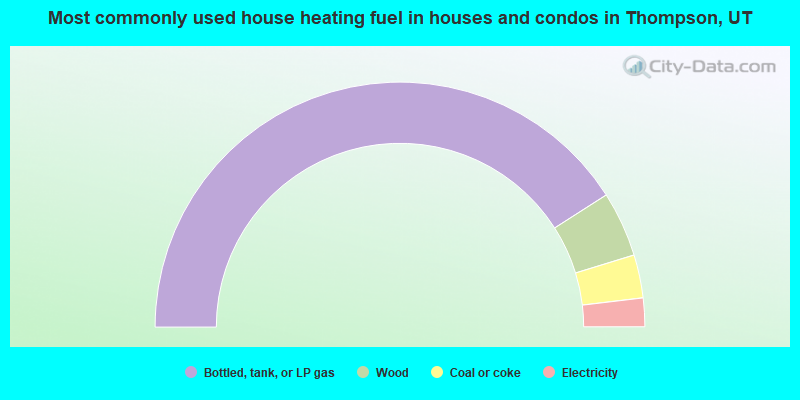
- 81.9%Bottled, tank, or LP gas
- 8.6%Wood
- 5.7%Coal or coke
- 3.8%Electricity
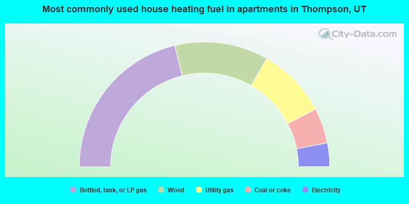
- 42.4%Bottled, tank, or LP gas
- 24.2%Wood
- 18.2%Utility gas
- 9.1%Coal or coke
- 6.1%Electricity
Thompson compared to Utah state average:
- Median household income significantly below state average.
- Unemployed percentage below state average.
- Median age above state average.
- Foreign-born population percentage significantly below state average.
- Renting percentage significantly below state average.
- Length of stay since moving in significantly above state average.
- Number of rooms per house significantly below state average.
- House age significantly below state average.
- Number of college students significantly below state average.
Thompson on our top lists:
- #27 on the list of "Top 100 cities with largest land areas"
- #28 (84540) on the list of "Top 101 zip codes with the largest percentage of Welsh first ancestries"
- #7 on the list of "Top 101 counties with highest percentage of residents voting for 3rd party candidates in the 2012 Presidential Election"