Tyringham, Massachusetts
Submit your own pictures of this town and show them to the world
- OSM Map
- General Map
- Google Map
- MSN Map

Population change since 2000: -6.6%
 |
| Males: 155 | |
| Females: 172 |
| Median resident age: | 57.2 years |
| Massachusetts median age: | 39.2 years |
Zip codes: 01238.
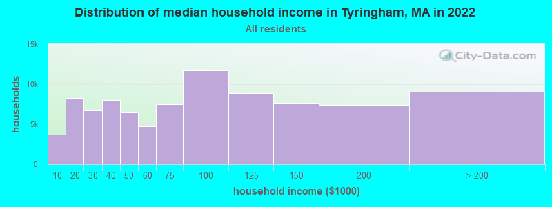
| Tyringham: | $114,454 |
| MA: | $94,488 |
Estimated per capita income in 2022: $79,633 (it was $35,503 in 2000)
Tyringham town income, earnings, and wages data
Estimated median house or condo value in 2022: $570,941 (it was $213,500 in 2000)
| Tyringham: | $570,941 |
| MA: | $534,700 |
Mean prices in 2022: all housing units: $357,971; detached houses: $376,086; townhouses or other attached units: $341,816; in 2-unit structures: $250,940; in 3-to-4-unit structures: $400,871; in 5-or-more-unit structures: $281,990; mobile homes: $80,872
Detailed information about poverty and poor residents in Tyringham, MA
Compare current foreclosures near Tyringham, MA:
| Photo | Address | Area | Beds / Baths | Price | Details |
|---|---|---|---|---|---|

|
#1
Crystal St
Lenox Dale, MA 01242
|
1,918 sq. feet
|
2 baths 3 beds |
$165,900
|
show details |

|
#2
Washington Mountain Rd
Lee, MA 01238
|
- sq. feet
|
1 baths 3 beds |
$155,000
|
show details |

|
#3
Circular Ave
Pittsfield, MA 01201
|
2,808 sq. feet
|
4 baths 8 beds |
show details | |

|
#4
Weller Ave
Pittsfield, MA 01201
|
3,376 sq. feet
|
3 baths 6 beds |
show details | |

|
#5
Daniels Ave
Pittsfield, MA 01201
|
3,040 sq. feet
|
3 baths 6 beds |
show details | |

|
#6
Robbins Ave
Pittsfield, MA 01201
|
1,872 sq. feet
|
2 baths 4 beds |
show details | |

|
#7
Madison Ave
Pittsfield, MA 01201
|
2,192 sq. feet
|
2 baths 6 beds |
show details | |

|
#8
Russell Stage Rd
Blandford, MA 01008
|
1,650 sq. feet
|
2 baths 3 beds |
show details | |

|
#9
North St
Pittsfield, MA 01201
|
1,661 sq. feet
|
2 baths 4 beds |
show details | |

|
#10
West St
Pittsfield, MA 01201
|
2,018 sq. feet
|
1 baths 3 beds |
show details |
| Photo | Address | Area | Beds / Baths | Price | Details |
|---|---|---|---|---|---|

|
#11
Briggs Ave
Pittsfield, MA 01201
|
2,116 sq. feet
|
2 baths 4 beds |
show details | |

|
#12
Elberon Ave
Pittsfield, MA 01201
|
1,794 sq. feet
|
1 baths 4 beds |
show details | |

|
#13
Summit Ave
Pittsfield, MA 01201
|
1,664 sq. feet
|
2 baths 4 beds |
show details | |

|
#14
Daniels Ave
Pittsfield, MA 01201
|
1,172 sq. feet
|
1 baths 3 beds |
show details | |

|
#15
S Undermountain Rd
Sheffield, MA 01257
|
1,713 sq. feet
|
2 baths 3 beds |
show details | |

|
#16
West St
Pittsfield, MA 01201
|
1,714 sq. feet
|
1 baths 4 beds |
show details | |

|
#17
Lenox Ave
Pittsfield, MA 01201
|
2,290 sq. feet
|
2 baths 6 beds |
show details | |

|
#18
Mcarthur St
Pittsfield, MA 01201
|
1,155 sq. feet
|
1 baths 2 beds |
show details | |

|
#19
Lenox Ave
Pittsfield, MA 01201
|
1,376 sq. feet
|
1 baths 3 beds |
show details | |

|
#20
Crystal St
Pittsfield, MA 01201
|
1,282 sq. feet
|
1 baths 3 beds |
show details |
| Photo | Address | Area | Beds / Baths | Price | Details |
|---|---|---|---|---|---|

|
#21
Imperial Ave
Pittsfield, MA 01201
|
1,326 sq. feet
|
1 baths 3 beds |
show details | |

|
#22
Ashuelot St
Dalton, MA 01226
|
1,792 sq. feet
|
2 baths 3 beds |
show details | |

|
#23
Davis St
Pittsfield, MA 01201
|
1,456 sq. feet
|
2 baths 3 beds |
show details | |

|
#24
David Dr
Hinsdale, MA 01235
|
1,664 sq. feet
|
2 baths 3 beds |
show details | |

|
#25
North St
Dalton, MA 01226
|
1,852 sq. feet
|
2 baths 4 beds |
show details | |

|
#26
Hancock Rd
Pittsfield, MA 01201
|
1,344 sq. feet
|
2 baths 3 beds |
show details | |

|
#27
Upper Queechy Rd
Canaan, NY 12029
|
912 sq. feet
|
1 baths 2 beds |
show details | |

|
#28
Woronoco Rd
Blandford, MA 01008
|
2,290 sq. feet
|
2 baths 10 beds |
show details | |

|
#29
Frisbee St
East Chatham, NY 12060
|
2,400 sq. feet
|
2 baths 4 beds |
show details | |

|
#30
Baker St
Lanesboro, MA 01237
|
1,231 sq. feet
|
1 baths 3 beds |
show details |
| Photo | Address | Area | Beds / Baths | Price | Details |
|---|---|---|---|---|---|

|
#31
East St
Lee, MA 01238
|
1,478 sq. feet
|
2 baths 3 beds |
show details | |

|
#32
Chapel St
Lee, MA 01238
|
1,584 sq. feet
|
1 baths 3 beds |
show details | |

|
#33
Donovan St
Pittsfield, MA 01201
|
1,652 sq. feet
|
2 baths 3 beds |
show details | |

|
#34
Williams St
Pittsfield, MA 01201
|
1,245 sq. feet
|
1 baths 3 beds |
show details | |

|
#35
Main St
Becket, MA 01223
|
1,512 sq. feet
|
2 baths 2 beds |
show details | |

|
#36
County Rd
Great Barrington, MA 01230
|
1,576 sq. feet
|
1 baths 4 beds |
show details | |

|
#37
Melville Ct
Lenox, MA 01240
|
3,988 sq. feet
|
6 baths 5 beds |
show details | |

|
#38
Jennifer St
Lenox, MA 01240
|
1,416 sq. feet
|
1 baths 3 beds |
show details | |

|
#39
Morgan St
Lenox, MA 01240
|
3,959 sq. feet
|
2 baths 3 beds |
show details | |

|
#40
Joseph Dr
Pittsfield, MA 01201
|
1,248 sq. feet
|
1 baths 3 beds |
show details |
| Photo | Address | Area | Beds / Baths | Price | Details |
|---|---|---|---|---|---|

|
#41
Middlefield Rd
Chester, MA 01011
|
1,760 sq. feet
|
2 baths 3 beds |
show details | |

|
#42
Anita Dr
Pittsfield, MA 01201
|
1,504 sq. feet
|
2 baths 3 beds |
show details | |

|
#43
Main St
Sheffield, MA 01257
|
3,683 sq. feet
|
5 baths 6 beds |
show details | |

|
#44
S Sandisfield Rd
Great Barrington, MA 01230
|
1,983 sq. feet
|
2 baths 2 beds |
show details | |

|
#45
Marshall Ave
Pittsfield, MA 01201
|
1,517 sq. feet
|
1 baths 3 beds |
show details | |

|
#46
S Washington State Rd
Becket, MA 01223
|
1,620 sq. feet
|
1 baths 2 beds |
show details | |

|
#47
Blair Rd
Blandford, MA 01008
|
1,580 sq. feet
|
1 baths 3 beds |
show details | |

|
#48
Kathy Way
Pittsfield, MA 01201
|
2,136 sq. feet
|
2 baths 3 beds |
show details | |

|
#49
Longfellow Ave
Pittsfield, MA 01201
|
1,356 sq. feet
|
1 baths 4 beds |
show details | |

|
Check over 1 million property listings on Foreclosure.com!
|
browse all offers | |||

- 31897.2%White alone
- 30.9%Black alone
- 30.9%Asian alone
- 30.9%Hispanic
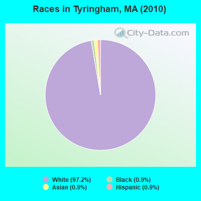
Races in Tyringham detailed stats: ancestries, foreign born residents, place of birth
 Recent articles from our blog. Our writers, many of them Ph.D. graduates or candidates, create easy-to-read articles on a wide variety of topics.


 | Is it possible to escape hunters, ATVs and noise in a rural area? (278 replies) |
| Christmas Music Sing-Off (35 replies) |
| Best Berkshire's weekend (26 replies) |
| How Much Massachusetts Households Make Per Year: Census Data (37 replies) |
| 2nd home in the Berkshires (22 replies) |
| Tiny western towns of Massachusetts ...any recommendations? (27 replies) |
Latest news from Tyringham, MA collected exclusively by city-data.com from local newspapers, TV, and radio stations
Ancestries: English (25.4%), Irish (16.0%), German (10.9%), French (8.9%), Italian (8.9%), United States (7.1%).
Current Local Time: EST time zone
Incorporated in 1762
Elevation: 901 feet
Land area: 18.7 square miles.
Population density: 17 people per square mile (very low).
12 residents are foreign born (1.4% Europe, 1.4% Oceania, 0.6% Asia).
| This town: | 3.4% |
| Massachusetts: | 12.2% |
| Tyringham town: | 0.8% ($1,615) |
| Massachusetts: | 1.3% ($2,336) |
Nearest city with pop. 50,000+: Chicopee, MA  (32.1 miles , pop. 54,653).
Nearest city with pop. 200,000+: Bronx, NY (103.2 miles , pop. 1,332,650).
Nearest cities:
), ), )Latitude: 42.25 N, Longitude: 73.20 W
Area code commonly used in this area: 413

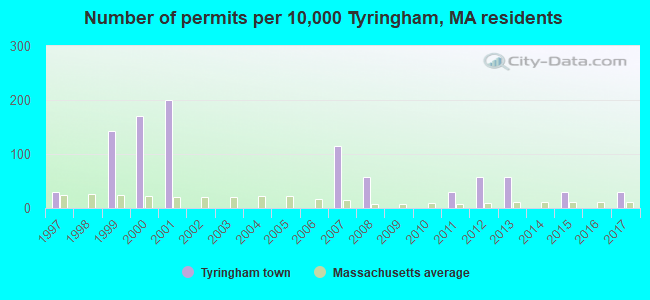
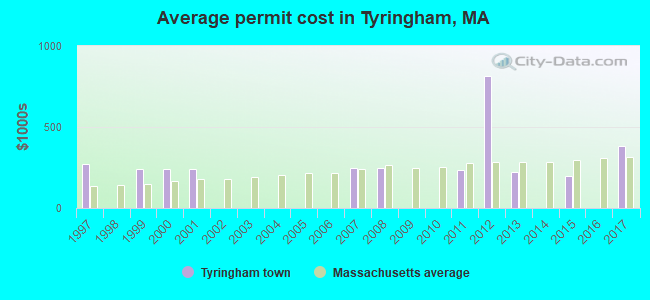
Single-family new house construction building permits:
- 2017: 1 building, cost: $385,000
- 2015: 1 building, cost: $200,000
- 2013: 2 buildings, average cost: $224,500
- 2012: 2 buildings, average cost: $815,000
- 2011: 1 building, cost: $235,000
- 2008: 2 buildings, average cost: $247,000
- 2007: 4 buildings, average cost: $247,000
- 2001: 7 buildings, average cost: $239,900
- 2000: 6 buildings, average cost: $239,900
- 1999: 5 buildings, average cost: $239,900
- 1997: 1 building, cost: $269,000
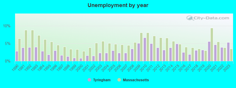
| Here: | 5.3% |
| Massachusetts: | 3.5% |
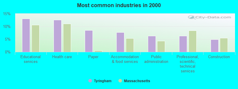
- Educational services (13.0%)
- Health care (12.6%)
- Paper (8.5%)
- Accommodation & food services (7.6%)
- Public administration (6.3%)
- Professional, scientific, technical services (6.3%)
- Construction (4.9%)
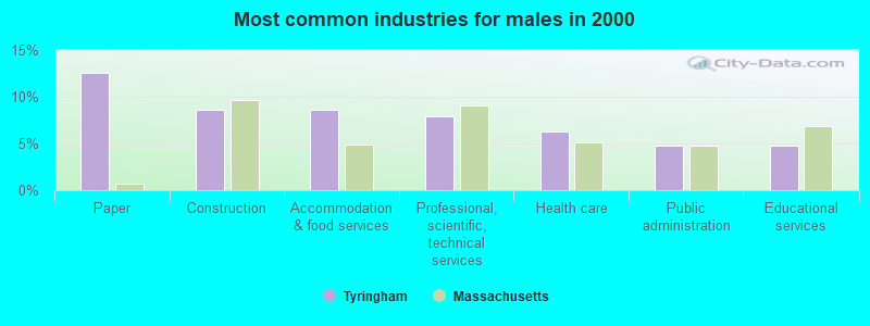
- Paper (12.6%)
- Construction (8.7%)
- Accommodation & food services (8.7%)
- Professional, scientific, technical services (7.9%)
- Health care (6.3%)
- Public administration (4.7%)
- Educational services (4.7%)
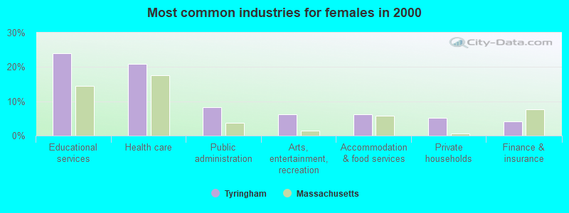
- Educational services (24.0%)
- Health care (20.8%)
- Public administration (8.3%)
- Arts, entertainment, recreation (6.2%)
- Accommodation & food services (6.2%)
- Private households (5.2%)
- Finance & insurance (4.2%)
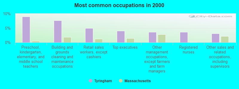
- Preschool, kindergarten, elementary, and middle school teachers (9.0%)
- Building and grounds cleaning and maintenance occupations (7.6%)
- Retail sales workers, except cashiers (4.9%)
- Top executives (4.0%)
- Other management occupations, except farmers and farm managers (3.6%)
- Registered nurses (3.6%)
- Other sales and related occupations, including supervisors (3.1%)
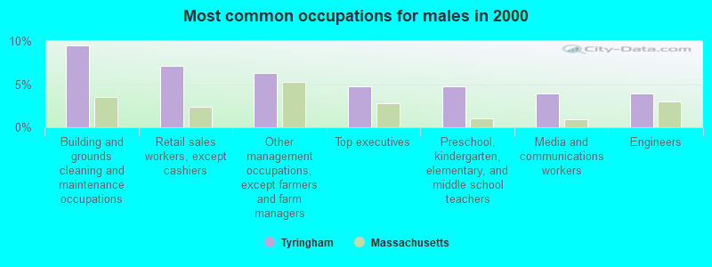
- Building and grounds cleaning and maintenance occupations (9.4%)
- Retail sales workers, except cashiers (7.1%)
- Other management occupations, except farmers and farm managers (6.3%)
- Top executives (4.7%)
- Preschool, kindergarten, elementary, and middle school teachers (4.7%)
- Media and communications workers (3.9%)
- Engineers (3.9%)
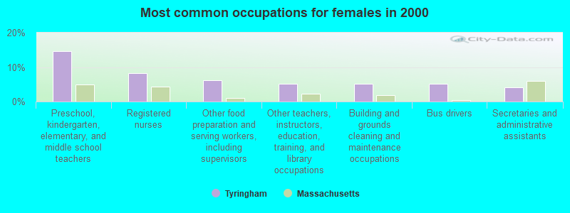
- Preschool, kindergarten, elementary, and middle school teachers (14.6%)
- Registered nurses (8.3%)
- Other food preparation and serving workers, including supervisors (6.2%)
- Other teachers, instructors, education, training, and library occupations (5.2%)
- Building and grounds cleaning and maintenance occupations (5.2%)
- Bus drivers (5.2%)
- Secretaries and administrative assistants (4.2%)
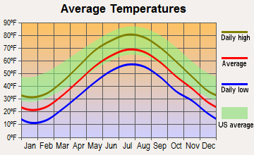
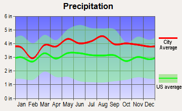
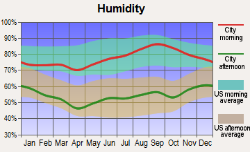
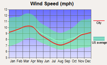
Average climate in Tyringham, Massachusetts
Based on data reported by over 4,000 weather stations
(lower is better)
Air Quality Index (AQI) level in 2022 was 63.2. This is about average.
| City: | 63.2 |
| U.S.: | 72.6 |
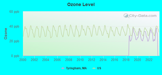
Ozone [ppb] level in 2022 was 27.5. This is better than average. Closest monitor was 13.4 miles away from the city center.
| City: | 27.5 |
| U.S.: | 33.3 |
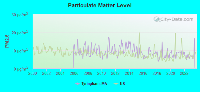
Particulate Matter (PM2.5) [µg/m3] level in 2022 was 6.76. This is about average. Closest monitor was 13.8 miles away from the city center.
| City: | 6.76 |
| U.S.: | 8.11 |
Tornado activity:
Tyringham-area historical tornado activity is slightly above Massachusetts state average. It is 16% smaller than the overall U.S. average.
On 5/29/1995, a category F4 (max. wind speeds 207-260 mph) tornado 6.0 miles away from the Tyringham town center killed 3 people and injured 24 people and caused between $5,000,000 and $50,000,000 in damages.
On 8/28/1973, a category F4 tornado 9.1 miles away from the town center killed 4 people and injured 36 people and caused between $5,000,000 and $50,000,000 in damages.
Earthquake activity:
Tyringham-area historical earthquake activity is significantly above Massachusetts state average. It is 69% smaller than the overall U.S. average.On 10/7/1983 at 10:18:46, a magnitude 5.3 (5.1 MB, 5.3 LG, 5.1 ML, Class: Moderate, Intensity: VI - VII) earthquake occurred 130.9 miles away from Tyringham center
On 4/20/2002 at 10:50:47, a magnitude 5.3 (5.3 ML, Depth: 3.0 mi) earthquake occurred 158.3 miles away from Tyringham center
On 4/20/2002 at 10:50:47, a magnitude 5.2 (5.2 MB, 4.2 MS, 5.2 MW, 5.0 MW) earthquake occurred 156.7 miles away from Tyringham center
On 1/19/1982 at 00:14:42, a magnitude 4.7 (4.5 MB, 4.7 MD, 4.5 LG, Class: Light, Intensity: IV - V) earthquake occurred 118.6 miles away from the city center
On 10/16/2012 at 23:12:25, a magnitude 4.7 (4.7 ML, Depth: 10.0 mi) earthquake occurred 159.1 miles away from Tyringham center
On 8/23/2011 at 17:51:04, a magnitude 5.8 (5.8 MW, Depth: 3.7 mi) earthquake occurred 390.9 miles away from Tyringham center
Magnitude types: regional Lg-wave magnitude (LG), body-wave magnitude (MB), duration magnitude (MD), local magnitude (ML), surface-wave magnitude (MS), moment magnitude (MW)
Natural disasters:
The number of natural disasters in Berkshire County (21) is greater than the US average (15).Major Disasters (Presidential) Declared: 10
Emergencies Declared: 10
Causes of natural disasters: Floods: 5, Snowstorms: 5, Storms: 5, Hurricanes: 4, Winter Storms: 4, Blizzards: 2, Snows: 2, Snowfall: 1, Tropical Storm: 1, Wind: 1, Other: 1 (Note: some incidents may be assigned to more than one category).

Hospitals and medical centers near Tyringham:
- LEE REGIONAL VNA INC. (Home Health Center, about 5 miles away; LEE, MA)
- KINDRED NURSING AND REHABILITATION-LAUREL LAKE (Nursing Home, about 6 miles away; LEE, MA)
- NURSING CARE CENTER AT KIMBALL (Nursing Home, about 8 miles away; LENOX, MA)
- EDGECOMBE NURSING HOME (Nursing Home, about 9 miles away; LENOX, MA)
- KIMBALL FARMS NURSING CARE CENTER (Nursing Home, about 9 miles away; LENOX, MA)
- FAIRVIEW HOSPITAL DIALYSIS CENTER (Dialysis Facility, about 10 miles away; GREAT BARRINGTON, MA)
- FAIRVIEW HOSPITAL Critical Access Hospitals (about 10 miles away; GREAT BARRINGTON, MA)
Colleges/universities with over 2000 students nearest to Tyringham:
- Westfield State University (about 23 miles; Westfield, MA; Full-time enrollment: 5,548)
- Holyoke Community College (about 29 miles; Holyoke, MA; FT enrollment: 4,911)
- Smith College (about 30 miles; Northampton, MA; FT enrollment: 3,549)
- Williams College (about 32 miles; Williamstown, MA; FT enrollment: 2,141)
- Mount Holyoke College (about 33 miles; South Hadley, MA; FT enrollment: 2,573)
- Springfield Technical Community College (about 34 miles; Springfield, MA; FT enrollment: 4,750)
- American International College (about 35 miles; Springfield, MA; FT enrollment: 2,733)
Points of interest:
Notable locations in Tyringham: Tyringham Fire Department (A), Gingerbread House (B). Display/hide their locations on the map
Reservoirs and swamps: Shaker Pond (A), Sodem Pond (B), Hale Pond (C), Goose Pond (D), Hale Swamp (E). Display/hide their locations on the map
Streams, rivers, and creeks: Higley Brook (A), Crystal Brook (B), Cooper Brook (C), Camp Brook (D). Display/hide their locations on the map
Birthplace of: Sylvester Smith (Latter Day Saints) - Mormon leader.
| This town: | 2.2 people |
| Massachusetts: | 2.5 people |
| This town: | 73.9% |
| Whole state: | 63.0% |
| This town: | 2.9% |
| Whole state: | 7.0% |
No gay or lesbian households reported
| This town: | 3.5% |
| Whole state: | 9.3% |
| This town: | 3.5% |
| Whole state: | 4.4% |
10 people in religious group quarters in 2000
For population 15 years and over in Tyringham:
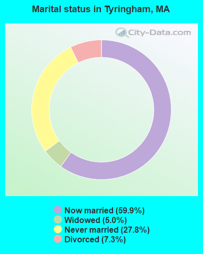
- Never married: 27.8%
- Now married: 59.9%
- Separated: 0.0%
- Widowed: 5.0%
- Divorced: 7.3%
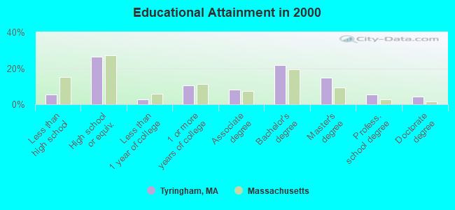
For population 25 years and over in Tyringham:
- High school or higher: 94.5%
- Bachelor's degree or higher: 46.5%
- Graduate or professional degree: 24.6%
- Unemployed: 1.8%
- Mean travel time to work (commute): 19.4 minutes
| Here: | 10.8 |
| Massachusetts average: | 13.1 |


Graphs represent county-level data. Detailed 2008 Election Results
Religion statistics for Tyringham, MA (based on Berkshire County data)


| Religion | Adherents | Congregations |
|---|---|---|
| Catholic | 50,187 | 32 |
| Mainline Protestant | 9,895 | 63 |
| Other | 3,647 | 20 |
| Evangelical Protestant | 2,817 | 28 |
| Black Protestant | 233 | 2 |
| Orthodox | 225 | 2 |
| None | 64,215 | - |
Food Environment Statistics:
| Berkshire County: | 2.54 / 10,000 pop. |
| State: | 1.98 / 10,000 pop. |
| This county: | 1.61 / 10,000 pop. |
| State: | 2.22 / 10,000 pop. |
| Berkshire County: | 4.08 / 10,000 pop. |
| Massachusetts: | 1.77 / 10,000 pop. |
| Berkshire County: | 15.00 / 10,000 pop. |
| Massachusetts: | 8.76 / 10,000 pop. |
| Here: | 8.0% |
| Massachusetts: | 8.1% |
| Berkshire County: | 22.8% |
| State: | 22.5% |
| Here: | 9.9% |
| Massachusetts: | 16.5% |
Strongest AM radio stations in Tyringham:
- WNNZ (640 AM; 50 kW; WESTFIELD, MA; Owner: CLEAR CHANNEL BROADCASTING LICENSES, INC.)
- WSBS (860 AM; 3 kW; GREAT BARRINGTON, MA; Owner: BERKSHIRE BROADCASTING CO., INC.)
- WTIC (1080 AM; 50 kW; HARTFORD, CT; Owner: INFINITY RADIO OPERATIONS INC.)
- WUHN (1110 AM; daytime; 5 kW; PITTSFIELD, MA; Owner: WEINER BROADCASTING, INC.)
- WGY (810 AM; 50 kW; SCHENECTADY, NY; Owner: CLEAR CHANNEL BROADCASTING LICENSES, INC.)
- WPTR (1540 AM; 50 kW; ALBANY, NY; Owner: KIMTRON, INC.)
- WCRN (830 AM; 50 kW; WORCESTER, MA; Owner: CARTER BROADCASTING CORPORATION)
- WHYN (560 AM; 5 kW; SPRINGFIELD, MA; Owner: CLEAR CHANNEL BROADCASTING LICENSES, INC.)
- WVNE (760 AM; daytime; 25 kW; LEICESTER, MA; Owner: BLOUNT MASSCOM, INC.)
- WACE (730 AM; 5 kW; CHICOPEE, MA; Owner: CARTER BROADCASTING CORP.)
- WFAN (660 AM; 50 kW; NEW YORK, NY; Owner: INFINITY BROADCASTING OPERATIONS, INC.)
- WALE (990 AM; 50 kW; GREENVILLE, RI; Owner: NORTH AMERICAN BROADCASTING CO., INC.)
- WRKO (680 AM; 50 kW; BOSTON, MA; Owner: ENTERCOM BOSTON LICENSE, LLC)
Strongest FM radio stations in Tyringham:
- WHVP (91.1 FM; HUDSON, NY; Owner: SOUND OF LIFE, INC.)
- WAMC-FM (90.3 FM; ALBANY, NY; Owner: WAMC)
- WAMQ (105.1 FM; GREAT BARRINGTON, MA; Owner: WAMC)
- WBEC-FM (105.5 FM; PITTSFIELD, MA; Owner: GREAT NORTHERN RADIO, LLC)
- WUPE (95.9 FM; PITTSFIELD, MA; Owner: WEINER BROADCASTING, INC.)
- WHYN-FM (93.1 FM; SPRINGFIELD, MA; Owner: CLEAR CHANNEL BROADCASTING LICENSES, INC.)
- WRNX (100.9 FM; AMHERST, MA; Owner: WESTERN MASSACHUSETTS RADIO COMPANY)
- WEQX (102.7 FM; MANCHESTER, VT; Owner: NORTHSHIRE COMMUNICATIONS, INC.)
- WJAN (95.1 FM; SUNDERLAND, VT; Owner: 6 JOHNSON ROAD LICENSES, INC.)
- WZEC (97.5 FM; HOOSICK FALLS, NY; Owner: GREAT NORTHERN RADIO, LLC)
- WAQY (102.1 FM; SPRINGFIELD, MA; Owner: SAGA COMMUNICATIONS OF NEW ENGLAND, LLC)
- WAMK (90.9 FM; KINGSTON, NY; Owner: W A M C)
- WFGB (89.7 FM; KINGSTON, NY; Owner: SOUND OF LIFE, INC.)
- WRCH (100.5 FM; NEW BRITAIN, CT; Owner: INFINITY RADIO OPERATIONS INC.)
- WVAY (100.7 FM; WILMINGTON, VT; Owner: GREAT NORTHERN RADIO, L.L.C.)
- WPDH (101.5 FM; POUGHKEEPSIE, NY; Owner: CUMULUS LICENSING CORP.)
- WFCR (88.5 FM; AMHERST, MA; Owner: UNIVERSITY OF MASSACHUSETTS)
- WKZE-FM (98.1 FM; SALISBURY, CT; Owner: JOHNSON DEVELOPMENT, INC.)
- WPKX (97.9 FM; ENFIELD, CT; Owner: CAPSTAR TX LIMITED PARTNERSHIP)
- WTIC-FM (96.5 FM; HARTFORD, CT; Owner: INFINITY RADIO OPERATIONS INC.)
TV broadcast stations around Tyringham:
- WTIC-TV (Channel 61; HARTFORD, CT; Owner: TRIBUNE TELEVISION COMPANY)
- W11BJ (Channel 11; HARTFORD, CT; Owner: COMMUNICATIONS SITE MANAGEMENT LLC)
- WTXX (Channel 20; WATERBURY, CT; Owner: WTXX INC.)
- WUVN (Channel 18; HARTFORD, CT; Owner: ENTRAVISION HOLDINGS, LLC)
- WVIT (Channel 30; NEW BRITAIN, CT; Owner: OUTLET BROADCASTING, INC)
- WEDH (Channel 24; HARTFORD, CT; Owner: CONNECTICUT PUBLIC BROADCASTING, INC.)
- WWLP (Channel 22; SPRINGFIELD, MA; Owner: WWLP BROADCASTING, LLC)
- National Bridge Inventory (NBI) Statistics
- 6Number of bridges
- 23ft / 7.0mTotal length
- $5,820,000Total costs
- 3,529Total average daily traffic
- 103Total average daily truck traffic
FCC Registered Broadcast Land Mobile Towers:
1- Main St (Lat: 42.247306 Lon: -73.205667), Call Sign: KDP422,
Assigned Frequencies: 154.310 MHz, Grant Date: 02/08/2011, Expiration Date: 01/03/2021, Cancellation Date: 03/06/2021, Registrant: Washington Radio Reports, 1588 Fairfield Road Ste 7, Gettysburg, PA 17325, Phone: (717) 334-0668, Fax: (717) 334-6440
FCC Registered Amateur Radio Licenses:
1- Call Sign: K1NP, Previous Call Sign: KB1BZH, Grant Date: 11/04/1996, Expiration Date: 11/04/2006, Cancellation Date: 11/05/2008, Registrant: Tyringham Bandits Arc, Main Rd, Tyringham, MA 01264
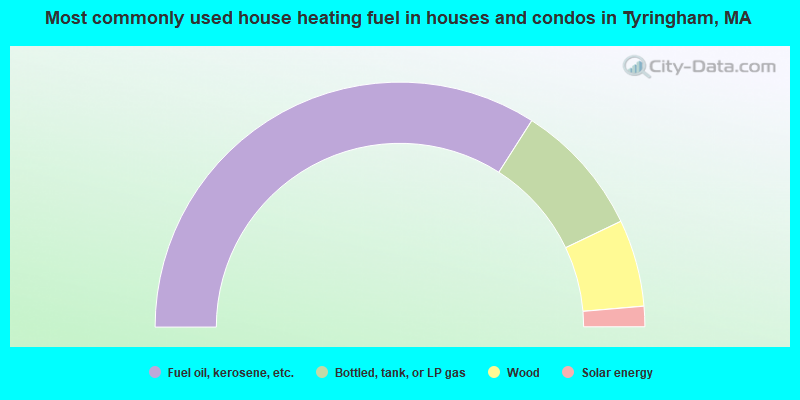
- 68.1%Fuel oil, kerosene, etc.
- 17.7%Bottled, tank, or LP gas
- 11.5%Wood
- 2.7%Solar energy
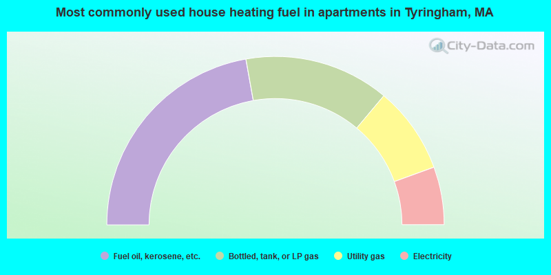
- 44.4%Fuel oil, kerosene, etc.
- 27.8%Bottled, tank, or LP gas
- 16.7%Utility gas
- 11.1%Electricity
Tyringham compared to Massachusetts state average:
- Unemployed percentage significantly below state average.
- Black race population percentage significantly below state average.
- Hispanic race population percentage significantly below state average.
- Median age significantly above state average.
- Foreign-born population percentage significantly below state average.
- Renting percentage significantly below state average.
- Length of stay since moving in significantly above state average.
- Number of rooms per house significantly below state average.
- House age significantly below state average.
- Number of college students below state average.

|
Total of 1 patent application in 2008-2024.