Table Land, Colorado
Submit your own pictures of this place and show them to the world
- OSM Map
- General Map
- Google Map
- MSN Map

| Males: 194 | |
| Females: 173 |
| Median resident age: | 45.5 years |
| Colorado median age: | 34.3 years |
Zip code: 80744
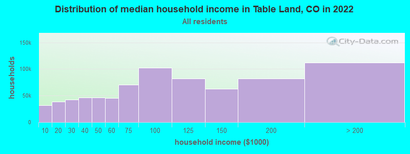
| Table Land: | $49,823 |
| CO: | $89,302 |
Estimated per capita income in 2022: $47,166 (it was $22,389 in 2000)
Table Land CCD income, earnings, and wages data
Estimated median house or condo value in 2022: $199,549 (it was $77,100 in 2000)
| Table Land: | $199,549 |
| CO: | $531,100 |
Mean prices in 2022: all housing units: $225,843; detached houses: $231,979; in 5-or-more-unit structures: $175,552; mobile homes: $81,798
Detailed information about poverty and poor residents in Table Land, CO
Compare current foreclosures near Table Land, CO:
| Photo | Address | Area | Beds / Baths | Price | Details |
|---|---|---|---|---|---|

|
#1
Columbia Dr
Julesburg, CO 80737
|
1,872 sq. feet
|
1 baths 3 beds |
show details | |

|
Check over 1 million property listings on Foreclosure.com!
|
browse all offers | |||

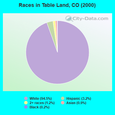
- 40994.5%White alone
- 143.2%Hispanic
- 51.2%Two or more races
- 40.9%Asian alone
- 10.2%Black alone
 Recent articles from our blog. Our writers, many of them Ph.D. graduates or candidates, create easy-to-read articles on a wide variety of topics.
Current Local Time: MST time zone
Land area: 447.4 square miles.
Population density: 0.8 people per square mile (very low).

| Table Land CCD: | 0.6% ($500) |
| Colorado: | 0.7% ($1,132) |
Nearest city with pop. 50,000+: Greeley, CO  (130.9 miles , pop. 76,930).
Nearest city with pop. 200,000+: Aurora, CO (154.5 miles , pop. 276,393).
Nearest city with pop. 1,000,000+: Dallas, TX (634.2 miles , pop. 1,188,580).
Nearest cities:
Latitude: 40.84 N, Longitude: 102.30 W

| Here: | 3.6% |
| Colorado: | 3.2% |
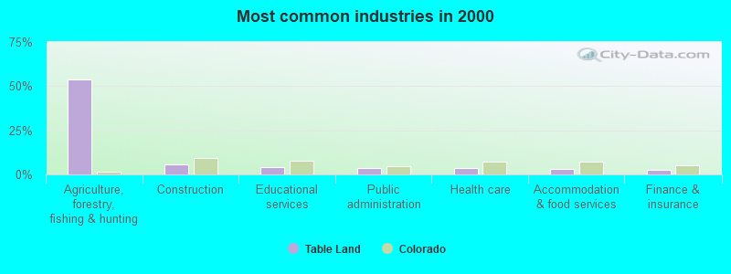
- Agriculture, forestry, fishing & hunting (53.9%)
- Construction (5.8%)
- Educational services (4.1%)
- Public administration (3.7%)
- Health care (3.7%)
- Accommodation & food services (3.3%)
- Finance & insurance (2.5%)
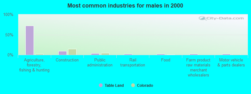
- Agriculture, forestry, fishing & hunting (72.5%)
- Construction (9.4%)
- Public administration (4.0%)
- Rail transportation (2.7%)
- Food (2.0%)
- Farm product raw materials merchant wholesalers (2.0%)
- Motor vehicle & parts dealers (2.0%)
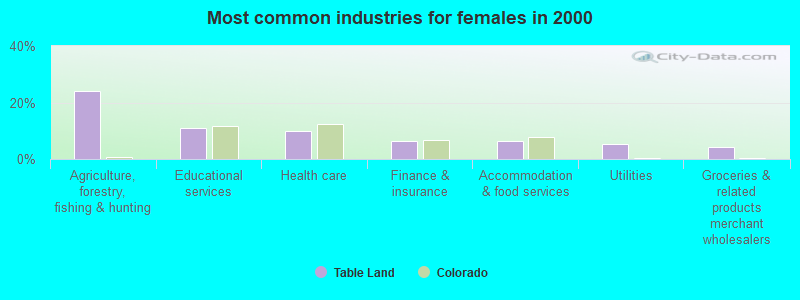
- Agriculture, forestry, fishing & hunting (23.9%)
- Educational services (10.9%)
- Health care (9.8%)
- Finance & insurance (6.5%)
- Accommodation & food services (6.5%)
- Utilities (5.4%)
- Groceries & related products merchant wholesalers (4.3%)
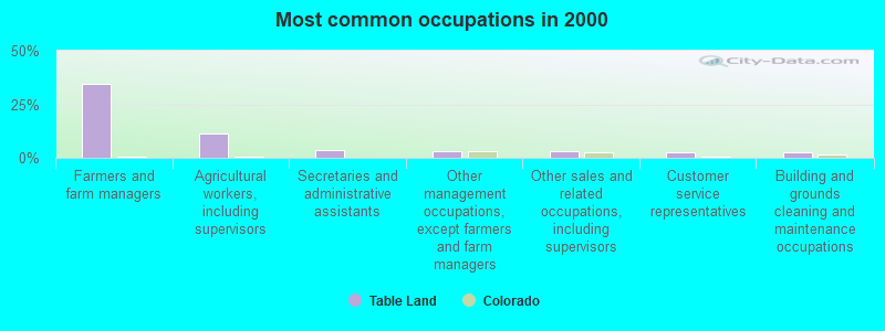
- Farmers and farm managers (34.4%)
- Agricultural workers, including supervisors (11.2%)
- Secretaries and administrative assistants (3.7%)
- Other management occupations, except farmers and farm managers (3.3%)
- Other sales and related occupations, including supervisors (2.9%)
- Customer service representatives (2.5%)
- Building and grounds cleaning and maintenance occupations (2.5%)
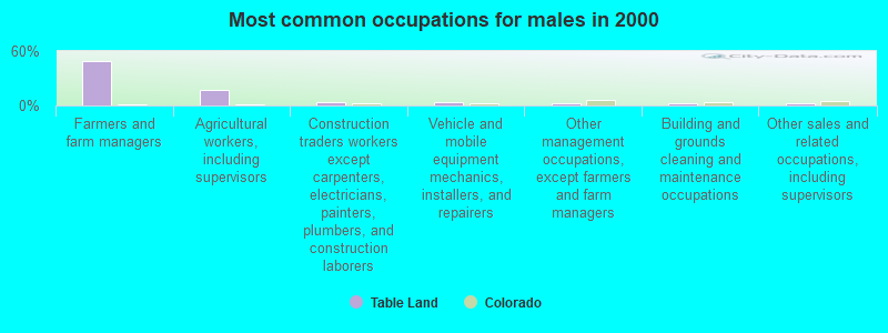
- Farmers and farm managers (49.0%)
- Agricultural workers, including supervisors (16.8%)
- Construction traders workers except carpenters, electricians, painters, plumbers, and construction laborers (4.0%)
- Vehicle and mobile equipment mechanics, installers, and repairers (4.0%)
- Other management occupations, except farmers and farm managers (2.7%)
- Building and grounds cleaning and maintenance occupations (2.7%)
- Other sales and related occupations, including supervisors (2.7%)
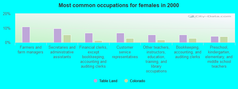
- Farmers and farm managers (10.9%)
- Secretaries and administrative assistants (9.8%)
- Financial clerks, except bookkeeping, accounting and auditing clerks (6.5%)
- Customer service representatives (6.5%)
- Other teachers, instructors, education, training, and library occupations (5.4%)
- Bookkeeping, accounting, and auditing clerks (5.4%)
- Preschool, kindergarten, elementary, and middle school teachers (4.3%)
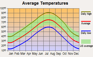
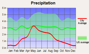
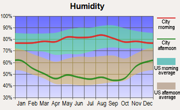
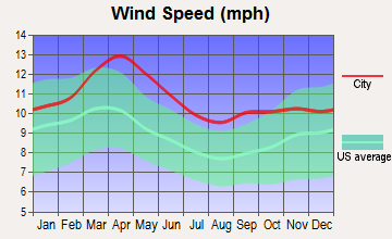
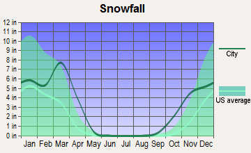
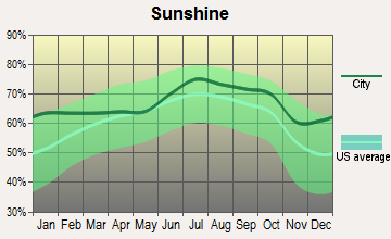
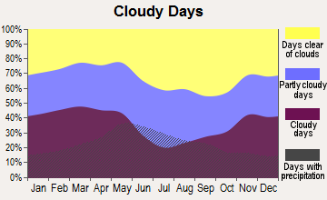
Average climate in Table Land, Colorado
Based on data reported by over 4,000 weather stations
Tornado activity:
Table Land-area historical tornado activity is above Colorado state average. It is 0% smaller than the overall U.S. average.
On 6/27/1960, a category F3 (max. wind speeds 158-206 mph) tornado 6.8 miles away from the Table Land place center killed 2 people and injured 3 people and caused between $50,000 and $500,000 in damages.
On 6/27/1960, a category F3 tornado 18.7 miles away from the place center injured one person and caused between $50,000 and $500,000 in damages.
Earthquake activity:
Table Land-area historical earthquake activity is significantly above Colorado state average. It is 468% greater than the overall U.S. average.On 8/18/1959 at 06:37:13, a magnitude 7.7 (7.7 UK, Class: Major, Intensity: VIII - XII) earthquake occurred 496.4 miles away from Table Land center, causing $26,000,000 total damage
On 10/18/1984 at 15:30:23, a magnitude 5.5 (5.4 MB, 5.1 MS, 5.5 ML, Class: Moderate, Intensity: VI - VII) earthquake occurred 200.3 miles away from the city center
On 8/23/2011 at 05:46:18, a magnitude 5.3 (5.3 MW, Depth: 2.5 mi) earthquake occurred 291.7 miles away from the city center
On 10/28/1983 at 14:06:06, a magnitude 7.3 (6.2 MB, 7.3 MS, 7.0 MW) earthquake occurred 627.6 miles away from Table Land center, causing 2 deaths (2 shaking deaths) and 3 injuries, causing $15,000,000 total damage
On 6/22/2019 at 08:50:24, a magnitude 4.6 (4.6 MW, Depth: 1.9 mi, Class: Light, Intensity: IV - V) earthquake occurred 189.2 miles away from Table Land center
On 9/8/1984 at 00:59:31, a magnitude 5.1 (5.1 MB) earthquake occurred 298.3 miles away from the city center
Magnitude types: body-wave magnitude (MB), local magnitude (ML), surface-wave magnitude (MS), moment magnitude (MW)
Natural disasters:
The number of natural disasters in Sedgwick County (8) is smaller than the US average (15).Major Disasters (Presidential) Declared: 6
Emergencies Declared: 1
Causes of natural disasters: Floods: 5, Storms: 5, Landslides: 2, Mudslides: 2, Tornadoes: 2, Heavy Rain: 1, Hurricane: 1, Snow: 1, Other: 1 (Note: some incidents may be assigned to more than one category).
Colleges/universities with over 2000 students nearest to Table Land:
- University of Northern Colorado (about 130 miles; Greeley, CO; Full-time enrollment: 11,469)
- Laramie County Community College (about 132 miles; Cheyenne, WY; FT enrollment: 3,288)
- Aims Community College (about 134 miles; Greeley, CO; FT enrollment: 3,598)
- Chadron State College (about 142 miles; Chadron, NE; FT enrollment: 2,374)
- Colorado State University-Fort Collins (about 148 miles; Fort Collins, CO; FT enrollment: 25,099)
- Community College of Aurora (about 154 miles; Aurora, CO; FT enrollment: 4,730)
- Front Range Community College (about 159 miles; Westminster, CO; FT enrollment: 14,756)
Points of interest:
Notable locations in Table Land: Miller School (A), Prairie View School (B), Price Ranch (C), Sunrise School (D), Italian Caves (E). Display/hide their locations on the map
Cemeteries: Julesburg Cemetery (1), Woodham Cemetery (2). Display/hide their locations on the map
Reservoirs: Sand Creek Reservoir (A), Johnson Lake (B). Display/hide their locations on the map
Creek: Sand Creek (A). Display/hide its location on the map
Park in Table Land: Sand Draw Management Area (1). Display/hide its location on the map
| This place: | 2.3 people |
| Colorado: | 2.5 people |
| This place: | 50.0% |
| Whole state: | 65.9% |
| This place: | 2.6% |
| Whole state: | 5.5% |
No gay or lesbian households reported
| This place: | 8.8% |
| Whole state: | 9.3% |
| This place: | 1.0% |
| Whole state: | 4.1% |
For population 15 years and over in Table Land:
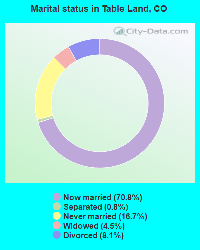
- Never married: 16.7%
- Now married: 70.8%
- Separated: 0.8%
- Widowed: 4.5%
- Divorced: 8.1%
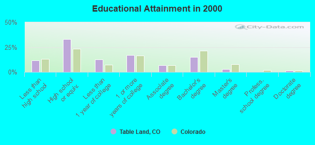
For population 25 years and over in Table Land:
- High school or higher: 88.4%
- Bachelor's degree or higher: 19.0%
- Graduate or professional degree: 4.2%
- Mean travel time to work (commute): 13.8 minutes
| Here: | 9.3 |
| Colorado average: | 11.8 |
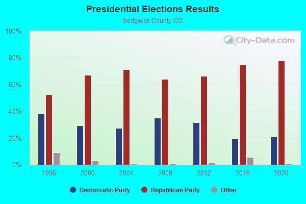
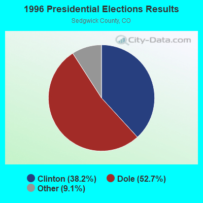

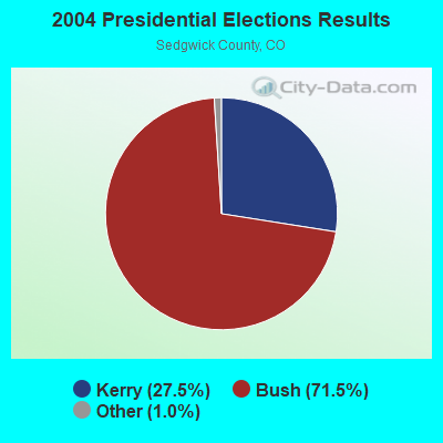


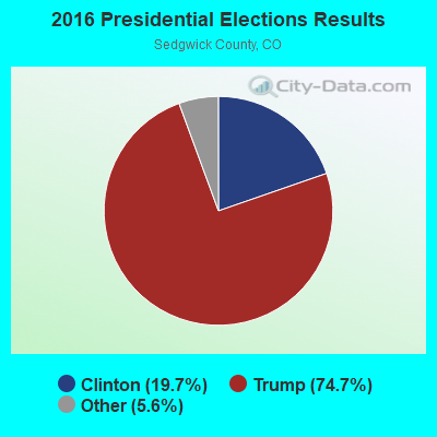
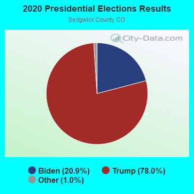
Graphs represent county-level data. Detailed 2008 Election Results
Religion statistics for Table Land, CO (based on Sedgwick County data)
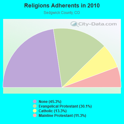
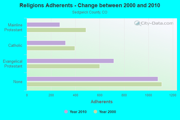
| Religion | Adherents | Congregations |
|---|---|---|
| Evangelical Protestant | 715 | 7 |
| Catholic | 317 | 2 |
| Mainline Protestant | 270 | 3 |
| None | 1,077 | - |
Food Environment Statistics:
| This county: | 4.29 / 10,000 pop. |
| Colorado: | 1.50 / 10,000 pop. |
| Sedgwick County: | 17.17 / 10,000 pop. |
| Colorado: | 8.99 / 10,000 pop. |
| This county: | 7.0% |
| Colorado: | 5.3% |
| This county: | 20.4% |
| Colorado: | 18.4% |
Strongest AM radio stations in Table Land:
- KIMB (1260 AM; 50 kW; KIMBALL, NE; Owner: G & L INVESTMENTS, LLC)
- KSIR (1010 AM; 25 kW; BRUSH, CO; Owner: JMS BROADCASTING, LLC)
- KOGA (930 AM; 5 kW; OGALLALA, NE; Owner: CAPSTAR TX LIMITED PARTNERSHIP)
- KLTT (670 AM; 50 kW; COMMERCE CITY, CO; Owner: KLZ RADIO, INC.)
- KKZN (760 AM; 50 kW; THORNTON, CO; Owner: JACOR BROADCASTING OF COLORADO, INC.)
- KRVN (880 AM; 50 kW; LEXINGTON, NE; Owner: NEBRASKA RURAL RADIO ASSOCIATION)
- KOA (850 AM; 50 kW; DENVER, CO; Owner: JACOR BROADCASTING OF COLORADO, INC.)
- KMXA (1090 AM; 50 kW; AURORA, CO; Owner: ENTRAVISION HOLDINGS, LLC)
- KRDZ (1440 AM; 5 kW; WRAY, CO; Owner: MEDIA LOGIC, LLC.)
- KLMO (1060 AM; 30 kW; LONGMONT, CO; Owner: PILGRIM COMMUNICATIONS, INC.)
- KJLT (970 AM; 5 kW; NORTH PLATTE, NE; Owner: TRI-STATE B/CING ASSOC., INC.)
- KTWO (1030 AM; 50 kW; CASPER, WY; Owner: CITICASTERS LICENSES, L.P.)
- KGAB (650 AM; 8 kW; ORCHARD VALLEY, WY; Owner: CITICASTERS LICENSES, L.P.)
Strongest FM radio stations in Table Land:
- K206BD (89.1 FM; JULESBURG, CO; Owner: REGION 1 TRANSLATOR ASSOCIATION)
- KADL (102.9 FM; IMPERIAL, NE; Owner: IMPERIAL MEDIA ASSOCIATION)
TV broadcast stations around Table Land:
- K35AB (Channel 35; JULESBURG, CO; Owner: REGION 1 TRANSLATOR ASSOCIATION)
- K41AB (Channel 41; JULESBURG, CO; Owner: REGION 1 TRANSLATOR ASSOCIATION)
- K31AB (Channel 31; JULESBURG, CO; Owner: REGION 1 TRANSLATOR ASSOCIATION)
- K39AC (Channel 39; JULESBURG, CO; Owner: REGION 1 TRANSLATOR ASSOCIATION)
- K43BY (Channel 43; JULESBURG, CO; Owner: REGION 1 TRANSLATOR ASSOCIATION)
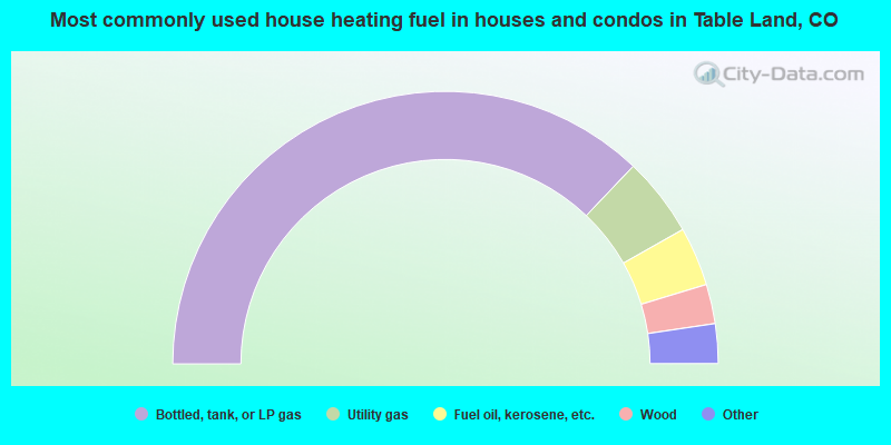
- 74.2%Bottled, tank, or LP gas
- 9.4%Utility gas
- 7.0%Fuel oil, kerosene, etc.
- 4.7%Wood
- 3.1%Electricity
- 1.6%Other fuel
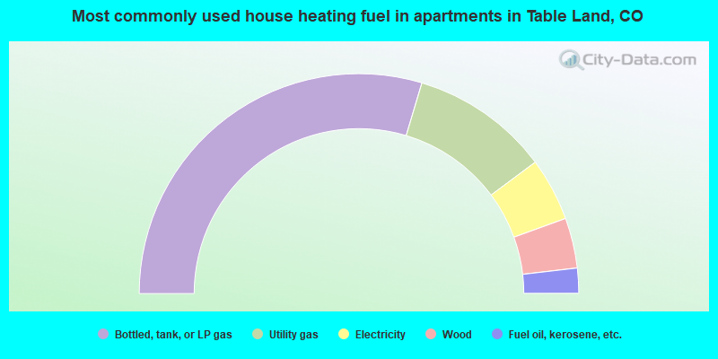
- 59.3%Bottled, tank, or LP gas
- 20.4%Utility gas
- 9.3%Electricity
- 7.4%Wood
- 3.7%Fuel oil, kerosene, etc.
Table Land compared to Colorado state average:
- Median household income below state average.
- Median house value significantly below state average.
- Unemployed percentage significantly below state average.
- Black race population percentage significantly below state average.
- Hispanic race population percentage significantly below state average.
- Median age above state average.
- Foreign-born population percentage significantly below state average.
- Renting percentage significantly below state average.
- Length of stay since moving in significantly above state average.
- Number of rooms per house significantly below state average.
- House age significantly below state average.
- Percentage of population with a bachelor's degree or higher below state average.
Table Land on our top lists:
- #45 on the list of "Top 100 highest located cities"