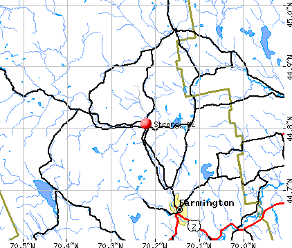
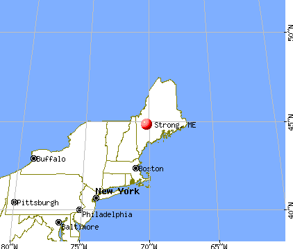
Strong, Maine

Submit your own pictures of this town and show them to the world
- OSM Map
- General Map
- Google Map
- MSN Map
Population change since 2000: -3.7%
 |
| Males: 621 | |
| Females: 592 |
| Median resident age: | 41.5 years |
| Maine median age: | 43.0 years |
Zip codes: 04983.
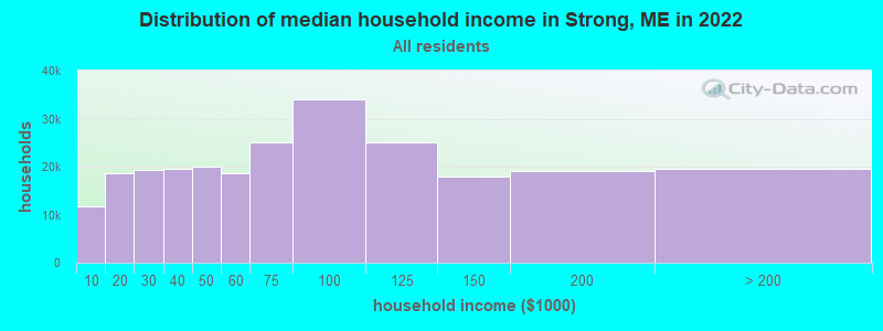
| Strong: | $56,325 |
| ME: | $69,543 |
Estimated per capita income in 2022: $30,983 (it was $14,232 in 2000)
Strong town income, earnings, and wages data
Estimated median house or condo value in 2022: $171,729 (it was $64,700 in 2000)
| Strong: | $171,729 |
| ME: | $290,600 |
Mean prices in 2022: all housing units: $249,382; detached houses: $272,823; townhouses or other attached units: $269,365; in 2-unit structures: $215,792; in 3-to-4-unit structures: $159,774; in 5-or-more-unit structures: $237,338; mobile homes: $71,957
Detailed information about poverty and poor residents in Strong, ME


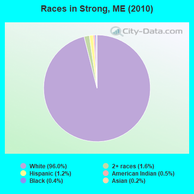
- 1,16496.0%White alone
- 201.6%Two or more races
- 141.2%Hispanic
- 60.5%American Indian alone
- 50.4%Black alone
- 30.2%Asian alone
- 10.08%Native Hawaiian and Other
Pacific Islander alone
Races in Strong detailed stats: ancestries, foreign born residents, place of birth
According to our research of Maine and other state lists, there were 7 registered sex offenders living in Strong, Maine as of May 08, 2024.
The ratio of all residents to sex offenders in Strong is 173 to 1.
 Recent articles from our blog. Our writers, many of them Ph.D. graduates or candidates, create easy-to-read articles on a wide variety of topics.

 | Maine weather thread (3207 replies) |
| Does Portland check all these boxes? (plus question about homeless) (15 replies) |
| Hope Island for sale for 8 million! (0 replies) |
| Vote NO on Federal Park (94 replies) |
| The Maine Growing season... (9 replies) |
| A Bunch of Subversives in Central Maine (62 replies) |
Latest news from Strong, ME collected exclusively by city-data.com from local newspapers, TV, and radio stations
Ancestries: English (32.0%), United States (13.7%), Irish (11.8%), French (10.3%), German (6.9%), Scottish (5.9%).
Current Local Time: EST time zone
Incorporated on 01/31/1801
Elevation: 501 feet
Land area: 28.7 square miles.
Population density: 42 people per square mile (very low).
11 residents are foreign born
| This town: | 0.9% |
| Maine: | 2.9% |
| Strong town: | 1.2% ($796) |
| Maine: | 1.5% ($1,417) |
Nearest city with pop. 50,000+: Portland, ME  (79.2 miles , pop. 64,249).
Nearest city with pop. 200,000+: Boston, MA (177.7 miles , pop. 589,141).
Nearest city with pop. 1,000,000+: Bronx, NY (331.3 miles , pop. 1,332,650).
Nearest cities:
), ), ), Latitude: 44.81 N, Longitude: 70.20 W
Area code: 207

| Here: | 4.1% |
| Maine: | 3.4% |
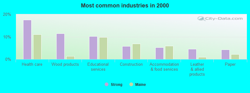
- Health care (17.5%)
- Wood products (11.5%)
- Educational services (10.2%)
- Construction (5.8%)
- Accommodation & food services (5.3%)
- Leather & allied products (4.5%)
- Paper (4.3%)
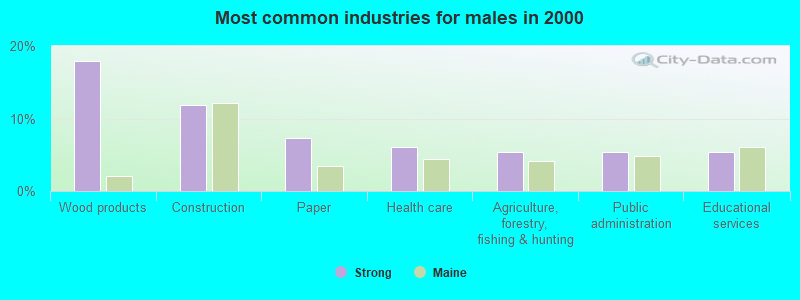
- Wood products (17.9%)
- Construction (11.8%)
- Paper (7.3%)
- Health care (6.1%)
- Agriculture, forestry, fishing & hunting (5.3%)
- Public administration (5.3%)
- Educational services (5.3%)
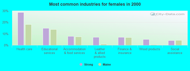
- Health care (28.7%)
- Educational services (14.9%)
- Accommodation & food services (7.8%)
- Leather & allied products (7.1%)
- Finance & insurance (7.1%)
- Wood products (5.2%)
- Social assistance (4.1%)

- Other production occupations, including supervisors (9.1%)
- Preschool, kindergarten, elementary, and middle school teachers (4.5%)
- Other sales and related occupations, including supervisors (4.5%)
- Nursing, psychiatric, and home health aides (4.3%)
- Other management occupations, except farmers and farm managers (3.6%)
- Registered nurses (3.2%)
- Secretaries and administrative assistants (3.2%)
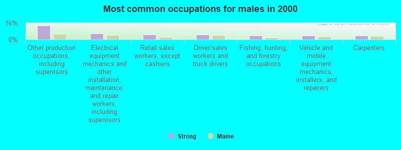
- Other production occupations, including supervisors (13.7%)
- Electrical equipment mechanics and other installation, maintenance, and repair workers, including supervisors (5.7%)
- Retail sales workers, except cashiers (5.0%)
- Driver/sales workers and truck drivers (5.0%)
- Fishing, hunting, and forestry occupations (3.8%)
- Vehicle and mobile equipment mechanics, installers, and repairers (3.8%)
- Carpenters (3.8%)

- Nursing, psychiatric, and home health aides (7.8%)
- Registered nurses (6.3%)
- Other sales and related occupations, including supervisors (6.3%)
- Secretaries and administrative assistants (6.3%)
- Preschool, kindergarten, elementary, and middle school teachers (6.3%)
- Other management occupations, except farmers and farm managers (4.5%)
- Cooks and food preparation workers (4.5%)
Average climate in Strong, Maine
Based on data reported by over 4,000 weather stations


(lower is better)
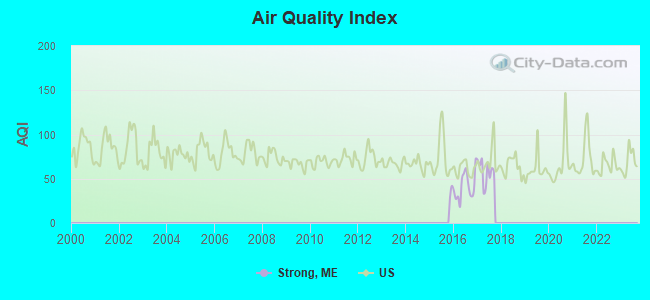
Air Quality Index (AQI) level in 2017 was 57.9. This is better than average.
| City: | 57.9 |
| U.S.: | 72.6 |
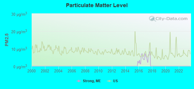
Particulate Matter (PM2.5) [µg/m3] level in 2017 was 5.59. This is significantly better than average. Closest monitor was 9.9 miles away from the city center.
| City: | 5.59 |
| U.S.: | 8.11 |
Earthquake activity:
Strong-area historical earthquake activity is significantly above Maine state average. It is 79% smaller than the overall U.S. average.On 4/20/2002 at 10:50:47, a magnitude 5.3 (5.3 ML, Depth: 3.0 mi, Class: Moderate, Intensity: VI - VII) earthquake occurred 173.3 miles away from Strong center
On 4/20/2002 at 10:50:47, a magnitude 5.2 (5.2 MB, 4.2 MS, 5.2 MW, 5.0 MW) earthquake occurred 174.5 miles away from Strong center
On 10/16/2012 at 23:12:25, a magnitude 4.7 (4.7 ML, Depth: 10.0 mi, Class: Light, Intensity: IV - V) earthquake occurred 86.8 miles away from Strong center
On 10/7/1983 at 10:18:46, a magnitude 5.3 (5.1 MB, 5.3 LG, 5.1 ML) earthquake occurred 213.1 miles away from the city center
On 1/19/1982 at 00:14:42, a magnitude 4.7 (4.5 MB, 4.7 MD, 4.5 LG) earthquake occurred 114.1 miles away from the city center
On 2/26/1999 at 03:38:43, a magnitude 3.8 (3.8 LG, Depth: 2.0 mi, Class: Light, Intensity: II - III) earthquake occurred 40.4 miles away from the city center
Magnitude types: regional Lg-wave magnitude (LG), body-wave magnitude (MB), duration magnitude (MD), local magnitude (ML), surface-wave magnitude (MS), moment magnitude (MW)
Natural disasters:
The number of natural disasters in Franklin County (27) is a lot greater than the US average (15).Major Disasters (Presidential) Declared: 19
Emergencies Declared: 7
Causes of natural disasters: Floods: 16, Storms: 14, Snows: 7, Heavy Rains: 2, Hurricanes: 2, Blizzard: 1, Ice Storm: 1, Landslide: 1, Snowfall: 1, Tropical Storm: 1, Wind: 1, Winter Storm: 1, Other: 2 (Note: some incidents may be assigned to more than one category).

Hospitals and medical centers in Strong:
Other hospitals and medical centers near Strong:
- EDGEWOOD REHAB AND LIVING CTR (Nursing Home, about 9 miles away; FARMINGTON, ME)
- ORCHARD PARK REHAB AND LIVING (Nursing Home, about 10 miles away; FARMINGTON, ME)
- SANDY RIVER CENTER (Nursing Home, about 14 miles away; FARMINGTON, ME)
- MAPLECREST REHAB AND LIVING CENTER (Nursing Home, about 16 miles away; MADISON, ME)
Colleges/universities with over 2000 students nearest to Strong:
- University of Maine at Farmington (about 11 miles; Farmington, ME; Full-time enrollment: 2,036)
- University of Maine at Augusta (about 39 miles; Augusta, ME; FT enrollment: 3,204)
- Husson University (about 70 miles; Bangor, ME; FT enrollment: 2,421)
- Saint Joseph's College of Maine (about 70 miles; Standish, ME; FT enrollment: 2,010)
- University of Maine (about 76 miles; Orono, ME; FT enrollment: 8,931)
- University of Southern Maine (about 80 miles; Portland, ME; FT enrollment: 6,647)
- Southern Maine Community College (about 81 miles; South Portland, ME; FT enrollment: 4,666)
Public elementary/middle school in Strong:
- STRONG ELEMENTARY SCHOOL (Location: 110 N MAIN STREET, Grades: KG-8)
Points of interest:
Notable location: Strong Fire Department (A). Display/hide its location on the map
Church in Strong: Strong United Methodist Church (A). Display/hide its location on the map
Cemetery: Strong Town Cemetery (1). Display/hide its location on the map
Lakes and reservoirs: Nash Pond (A), Taylor Hill Pond (B), Porter Lake (C). Display/hide their locations on the map
Streams, rivers, and creeks: Valley Brook (A), Winter Brook (B), McLeary Brook (C), Doctor Brook (D), Bean Brook (E). Display/hide their locations on the map
Tourist attraction: Maine Guide Service (Tours & Charters; 145 Church Hill) (1). Display/hide its approximate location on the map
Drinking water stations with addresses in Strong and their reported violations in the past:
STRONG WATER DISTRICT (Population served: 650, Groundwater):Past monitoring violations:
- 4 regular monitoring violations
| This town: | 2.5 people |
| Maine: | 2.3 people |
| This town: | 68.3% |
| Whole state: | 62.9% |
| This town: | 10.9% |
| Whole state: | 9.4% |
Likely homosexual households (counted as self-reported same-sex unmarried-partner households)
- Lesbian couples: 1.0% of all households
- Gay men: 0.0% of all households
| This town: | 15.3% |
| Whole state: | 10.9% |
| This town: | 4.2% |
| Whole state: | 4.1% |
5 people in homes for the mentally retarded in 2000
For population 15 years and over in Strong:
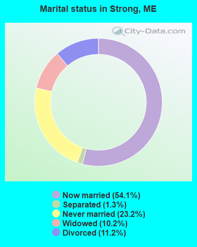
- Never married: 23.2%
- Now married: 54.1%
- Separated: 1.3%
- Widowed: 10.2%
- Divorced: 11.2%
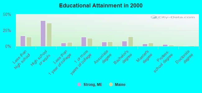
For population 25 years and over in Strong:
- High school or higher: 83.4%
- Bachelor's degree or higher: 15.8%
- Graduate or professional degree: 7.6%
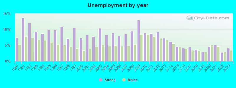
- Unemployed: 5.9%
- Mean travel time to work (commute): 29.0 minutes
| Here: | 11.2 |
| Maine average: | 11.2 |
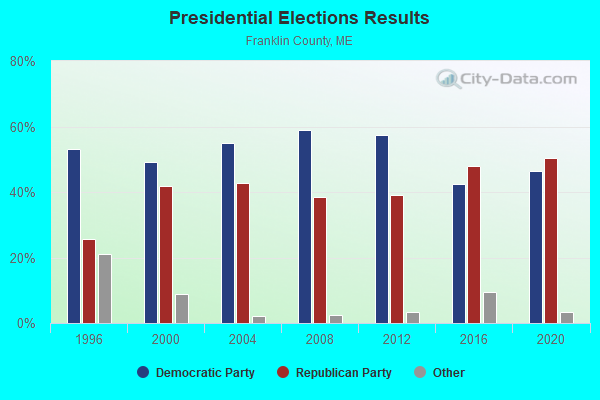
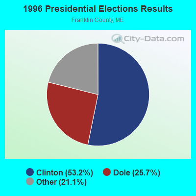
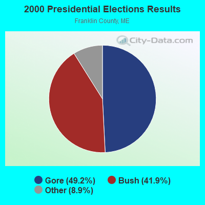
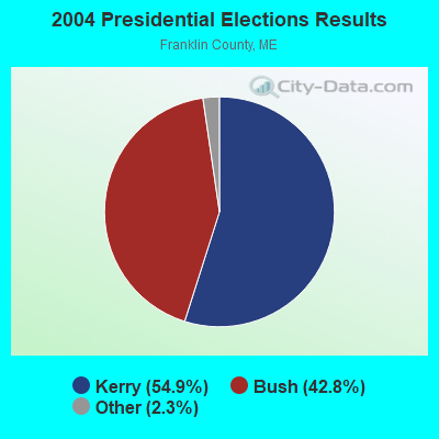

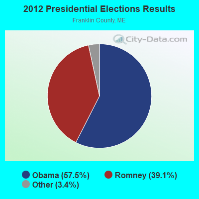


Graphs represent county-level data. Detailed 2008 Election Results
Religion statistics for Strong, ME (based on Franklin County data)
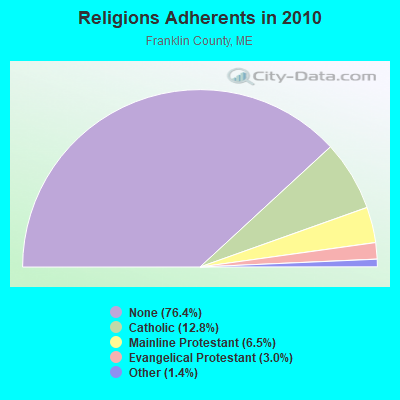
| Religion | Adherents | Congregations |
|---|---|---|
| Catholic | 3,936 | 5 |
| Mainline Protestant | 2,003 | 21 |
| Evangelical Protestant | 908 | 16 |
| Other | 427 | 2 |
| None | 23,494 | - |
Food Environment Statistics:
| This county: | 4.68 / 10,000 pop. |
| Maine: | 2.80 / 10,000 pop. |
| Franklin County: | 0.33 / 10,000 pop. |
| Maine: | 0.14 / 10,000 pop. |
| Franklin County: | 3.01 / 10,000 pop. |
| Maine: | 2.20 / 10,000 pop. |
| This county: | 6.69 / 10,000 pop. |
| Maine: | 5.75 / 10,000 pop. |
| This county: | 14.38 / 10,000 pop. |
| Maine: | 11.02 / 10,000 pop. |
| Franklin County: | 7.3% |
| State: | 8.2% |
| Franklin County: | 24.4% |
| State: | 25.0% |
Strongest AM radio stations in Strong:
- WTME (780 AM; 10 kW; RUMFORD, ME; Owner: MOUNTAIN VALLEY BROADCASTING, INC.)
- WSKW (1160 AM; 10 kW; SKOWHEGAN, ME; Owner: MOUNTAIN WIRELESS, INCORPORATED)
- WRKO (680 AM; 50 kW; BOSTON, MA; Owner: ENTERCOM BOSTON LICENSE, LLC)
- WFAU (1280 AM; 5 kW; GARDINER, ME; Owner: CAPSTAR TX LIMITED PARTNERSHIP)
- WCHP (760 AM; 35 kW; CHAMPLAIN, NY; Owner: CHAMPLAIN RADIO, INC.)
- WMTW (870 AM; 10 kW; GORHAM, ME; Owner: RADIO PARTNERS OF MAINE, L.P.)
- WEEI (850 AM; 50 kW; BOSTON, MA; Owner: ENTERCOM BOSTON LICENSE, LLC)
- WZON (620 AM; 5 kW; BANGOR, ME; Owner: THE ZONE CORPORATION)
- WBZ (1030 AM; 50 kW; BOSTON, MA; Owner: INFINITY BROADCASTING OPERATIONS, INC.)
- WCRN (830 AM; 50 kW; WORCESTER, MA; Owner: CARTER BROADCASTING CORPORATION)
- WNNZ (640 AM; 50 kW; WESTFIELD, MA; Owner: CLEAR CHANNEL BROADCASTING LICENSES, INC.)
- WGAN (560 AM; 5 kW; PORTLAND, ME; Owner: SAGA COMMUNICATIONS OF NEW ENGLAND, LLC)
- WLAM (1470 AM; 5 kW; LEWISTON, ME; Owner: RADIO PARTNERS OF MAINE, L.P.)
Strongest FM radio stations in Strong:
- WTOS-FM (105.1 FM; SKOWHEGAN, ME; Owner: CAPSTAR TX LIMITED PARTNERSHIP)
- WLOB-FM (96.3 FM; RUMFORD, ME; Owner: ATLANTIC COAST RADIO, LLC)
- WKTJ-FM (99.3 FM; FARMINGTON, ME; Owner: FRANKLIN BROADCASTING CORPORATION)
- WTBM (100.7 FM; MEXICO, ME; Owner: MOUNTAIN VALLEY BROADCASTING, INC.)
- WPKQ (103.7 FM; NORTH CONWAY, NH; Owner: CITADEL BROADCASTING COMPANY)
- WHOM (94.9 FM; MT. WASHINGTON, NH; Owner: CITADEL BROADCASTING COMPANY)
- WIGY (97.5 FM; MADISON, ME; Owner: CAPSTAR TX LIMITED PARTNERSHIP)
- WHQO (107.9 FM; SKOWHEGAN, ME; Owner: MOUNTAIN WIRELESS, INC.)
- WWWA (95.3 FM; WINSLOW, ME; Owner: LIGHT OF LIFE MINISTRIES, INC.)
TV broadcast stations around Strong:
- W21BI (Channel 21; FARMINGTON, ME; Owner: TRINITY BROADCASTING NETWORK)
- Strong, Maine
- Fatal accident count10
- Vehicles involved in fatal accidents16
- Fatal accidents involving drunk persons:10
- Fatalities11
- Persons involved in fatal accidents29
- Pedestrians involved in fatal accidents0
- Maine average
- Fatal accident count1849
- Vehicles involved in fatal accidents2528
- Fatal accidents involving drunk persons763
- Fatalities2036
- Persons involved in fatal accidents4579
- Pedestrians involved in fatal accidents96
- National Bridge Inventory (NBI) Statistics
- 6Number of bridges
- 52ft / 16.4mTotal length
- 6,787Total average daily traffic
- 336Total average daily truck traffic
- 10,054Total future (year 2036) average daily traffic
FCC Registered Cell Phone Towers:
1- Strong Cell Site Burbank Hill Road, Atop Jackson Mountain (Lat: 44.819500 Lon: -70.259500), Structure height: 96 m, Call Sign: KNKN659
Assigned Frequencies: 869.040 MHz, 890.010 MHz, 824.040 MHz, 845.010 MHzGrant Date: 08/31/2021, Expiration Date: 10/01/2031Registrant: Wilkinson Barker Knauer, LLP, 1800 M Street Nw, Suite 800n, Washington, DC 20036, Phone: (202) 383-3420, Fax: (202) 783-5851, Email:
FCC Registered Antenna Towers:
3- PETER M CONNOLLY, Burbank Hill Rd Atop Mount Jackson (Lat: 44.819722 Lon: -70.259444), Type: 96.0, Overall height: 91.4 m, Registrant: Holland & Knight LLP, Pconnoll@hklaw.Com, , Washi-ngton, Phone: (202) 862-5989
- Cayla Gamble, Burbank Hill Rd Atop Mount Jackson (Lat: 44.819722 Lon: -70.259444), Type: 96.0, Structure height: 23007 m, Overall height: 91.4 m, Registrant: Wilkinson Barker Knauer, LLP, Gwerner@wbklaw.Com, , Washi-ngton, Phone: (202) 383-3420
- Burbank Hill Rd Atop Mount Jackson (Lat: 44.819722 Lon: -70.259444), Type: 96.0, Overall height: 91.4 m, Registrant: United States Cellular Corporation, Linda.Hartman@koteen.Com, , Washi-ngton, Phone: (202) 467-5700
FCC Registered Microwave Towers:
2- STRONG, Burbank Hill Rd Atop Mount Jackson (Lat: 44.819722 Lon: -70.259444), Type: Tower, Structure height: 91.4 m, Overall height: 96 m, Call Sign: WPOS398,
Assigned Frequencies: 6585.00 MHz, Grant Date: 02/05/2019, Expiration Date: 03/09/2029, Cancellation Date: 03/25/2019, Registrant: Holland & Knight LLP, 800 17th Street, N.W., Suite 1100, Washington, DC 20006-3906, Phone: (202) 955-3000, Fax: (202) 955-5564, Email:
- Strong, Burbank Hill Rd Atop Mount Jackson (Lat: 44.819611 Lon: -70.259472), Type: Gtower, Structure height: 92.1 m, Overall height: 95.6 m, Call Sign: WQUU949,
Assigned Frequencies: 10815.0 MHz, 10815.0 MHz, 10815.0 MHz, 10815.0 MHz, 10815.0 MHz, 10815.0 MHz, 10815.0 MHz, 10815.0 MHz, 10815.0 MHz, 10735.0 MHz... (+8 more), Grant Date: 10/21/2014, Expiration Date: 10/21/2024, Cancellation Date: 10/21/2020, Certifier: Jessica B Lyons, Registrant: At&t Services, Inc., 208 S. Akard St., Room 2100, Dallas, TX 75202, Phone: (855) 699-7073, Email:
FCC Registered Amateur Radio Licenses:
14 (See the full list of FCC Registered Amateur Radio Licenses in Strong)FAA Registered Aircraft:
4- Aircraft: CESSNA 150L (Category: Land, Seats: 2, Weight: Up to 12,499 Pounds, Speed: 90 mph), Engine: CONT MOTOR 0-200 SERIES (100 HP) (Reciprocating)
N-Number: 10150, N10150, N-10150, Serial Number: 15074810, Year manufactured: 1973, Airworthiness Date: 07/06/1973, Certificate Issue Date: 04/17/2017
Registrant (Individual): Michael A Bolduc, Po Box 361, Strong, ME 04983 - Aircraft: TAYLORCRAFT BC-65 (Category: Land, Seats: 2, Weight: Up to 12,499 Pounds, Speed: 78 mph), Engine: CONT MOTOR A&C65 SERIES (65 HP) (Reciprocating)
N-Number: 24446, N24446, N-24446, Serial Number: 1783, Year manufactured: 1940, Certificate Issue Date: 06/02/1997
Registrant (Individual): Glen A Thompson, 930 S Strong Rd, Strong, ME 04983 - Aircraft: PIPER PA-28R-180 (Category: Land, Seats: 4, Weight: Up to 12,499 Pounds, Speed: 107 mph), Engine: LYCOMING I0360 SER (180 HP) (Reciprocating)
N-Number: 4559J, N4559J, N-4559J, Serial Number: 28R-30419, Year manufactured: 1968, Airworthiness Date: 02/08/1968, Certificate Issue Date: 05/14/2010
Registrant (Individual): Michael A Bolduc, Po Box 361, Strong, ME 04983 - Aircraft: TAYLORCRAFT BC12-D (Category: Land, Seats: 2, Weight: Up to 12,499 Pounds, Speed: 78 mph), Engine: CONT MOTOR A&C65 SERIES (65 HP) (Reciprocating)
N-Number: 96548, N96548, N-96548, Serial Number: 8848, Year manufactured: 1946, Airworthiness Date: 05/02/1991, Certificate Issue Date: 12/07/2017
Registrant (Individual): Glen A Thompson, 930 S Strong Rd, Strong, ME 04983
2004 - 2018 National Fire Incident Reporting System (NFIRS) incidents
- Fire incident types reported to NFIRS in Strong, ME
- 11981.5%Structure Fires
- 138.9%Mobile Property/Vehicle Fires
- 117.5%Outside Fires
- 32.1%Other
 Based on the data from the years 2004 - 2018 the average number of fire incidents per year is 10. The highest number of fires - 24 took place in 2007, and the least - 4 in 2018. The data has a dropping trend.
 When looking into fire subcategories, the most incidents belonged to: Structure Fires (81.5%), and Mobile Property/Vehicle Fires (8.9%).
- 71.3%Fuel oil, kerosene, etc.
- 24.3%Wood
- 2.5%Electricity
- 2.0%Bottled, tank, or LP gas
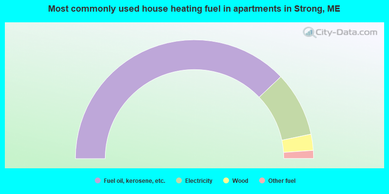
- 75.8%Fuel oil, kerosene, etc.
- 17.6%Electricity
- 4.4%Wood
- 2.2%Other fuel
Strong compared to Maine state average:
- Median house value below state average.
- Unemployed percentage below state average.
- Black race population percentage significantly below state average.
- Hispanic race population percentage below state average.
- Foreign-born population percentage significantly below state average.
- Length of stay since moving in significantly above state average.
- Number of rooms per house significantly below state average.
- House age significantly below state average.
- Percentage of population with a bachelor's degree or higher below state average.
Strong on our top lists:
- #98 on the list of "Top 101 cities with the largest percentage of people in other nonhousehold living situations (population 1,000+)"

|
Total of 4 patent applications in 2008-2024.