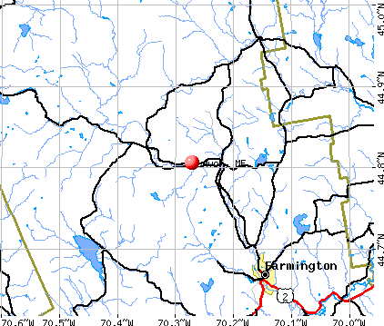
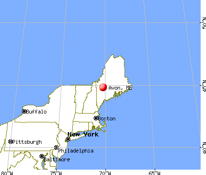
Avon, Maine

Avon: View from the top of Cross Road
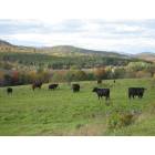
Avon: Grazing

Avon: OFF THE FISCHER ROAD IN AVON, MAINE

Avon: Picture taken from top of Mt. Blue Pond Rd. facing north toward Phillips and Rt. #4
- add
your
Submit your own pictures of this town and show them to the world
- OSM Map
- General Map
- Google Map
- MSN Map
Population change since 2000: -8.5%
 |
| Males: 222 | |
| Females: 239 |
| Median resident age: | 46.9 years |
| Maine median age: | 43.0 years |
Zip codes: 04966.
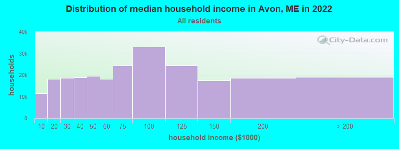
| Avon: | $54,766 |
| ME: | $69,543 |
Estimated per capita income in 2022: $33,903 (it was $15,573 in 2000)
Avon town income, earnings, and wages data
Estimated median house or condo value in 2022: $186,592 (it was $70,300 in 2000)
| Avon: | $186,592 |
| ME: | $290,600 |
Mean prices in 2022: all housing units: $249,382; detached houses: $272,823; townhouses or other attached units: $269,365; in 2-unit structures: $215,792; in 3-to-4-unit structures: $159,774; in 5-or-more-unit structures: $237,338; mobile homes: $71,957
Detailed information about poverty and poor residents in Avon, ME
Compare current foreclosures near Avon, ME:
| Photo | Address | Area | Beds / Baths | Price | Details |
|---|---|---|---|---|---|

|
#1
Back Kingdom Rd
Mexico, ME 04257
|
996 sq. feet
|
1 baths 1 beds |
show details | |

|
#2
Knapp St
Wilton, ME 04294
|
- sq. feet
|
2 baths 4 beds |
show details | |

|
#3
Bridge St
Phillips, ME 04966
|
- sq. feet
|
- baths - beds |
show details | |

|
#4
Fairbanks Rd
Farmington, ME 04938
|
3,194 sq. feet
|
- baths - beds |
show details | |

|
#5
New Vineyard Rd
New Vineyard, ME 04956
|
- sq. feet
|
- baths - beds |
show details | |

|
#6
Perham St Apt 13
Farmington, ME 04938
|
- sq. feet
|
- baths - beds |
show details | |

|
#7
Farrington Rd
Jay, ME 04239
|
- sq. feet
|
- baths - beds |
show details | |

|
#8
Norton Rd
Dixfield, ME 04224
|
- sq. feet
|
- baths - beds |
show details | |

|
#9
Morgan Ln
Farmington, ME 04938
|
- sq. feet
|
- baths - beds |
show details | |

|
#10
Chesterville Rd
Jay, ME 04239
|
- sq. feet
|
- baths - beds |
show details |
| Photo | Address | Area | Beds / Baths | Price | Details |
|---|---|---|---|---|---|

|
Check over 1 million property listings on Foreclosure.com!
|
browse all offers | |||
| Photo | Address | Area | Beds / Baths | Price | Details |
|---|

- 45097.6%White alone
- 51.1%Hispanic
- 30.7%Black alone
- 20.4%Two or more races
- 10.2%Asian alone
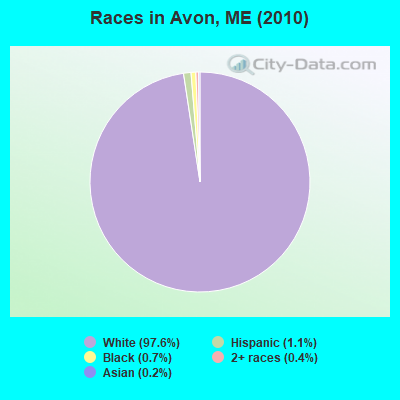
Races in Avon detailed stats: ancestries, foreign born residents, place of birth
 Recent articles from our blog. Our writers, many of them Ph.D. graduates or candidates, create easy-to-read articles on a wide variety of topics.

 | Maine weather thread (3207 replies) |
| Move from Alaska to Maine? (90 replies) |
| Pros and Cons of Maine (103 replies) |
| Coastal Maine - Mosquitoes? (10 replies) |
| Is Southern Maine "Family Friendly"? (90 replies) |
| I'm 1/2 way set to move to The Pinetree State... (10 replies) |
Latest news from Avon, ME collected exclusively by city-data.com from local newspapers, TV, and radio stations
Ancestries: United States (43.1%), English (30.2%), French (8.1%), Irish (6.9%), German (4.6%), Scottish (2.8%).
Current Local Time: EST time zone
Incorporated on 02/22/1802
Elevation: 493 feet
Land area: 41.3 square miles.
Population density: 11 people per square mile (very low).
3 residents are foreign born
| This town: | 0.6% |
| Maine: | 2.9% |
| Avon town: | 0.9% ($664) |
| Maine: | 1.5% ($1,417) |
Nearest city with pop. 50,000+: Portland, ME  (77.8 miles , pop. 64,249).
Nearest city with pop. 200,000+: Boston, MA (175.0 miles , pop. 589,141).
Nearest city with pop. 1,000,000+: Bronx, NY (326.7 miles , pop. 1,332,650).
Nearest cities:
), ), )Latitude: 44.79 N, Longitude: 70.32 W
Area code commonly used in this area: 207

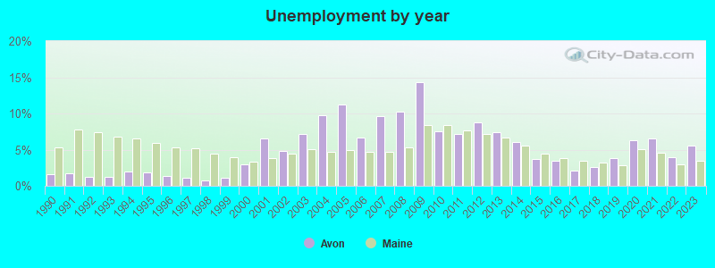
| Here: | 5.6% |
| Maine: | 3.4% |
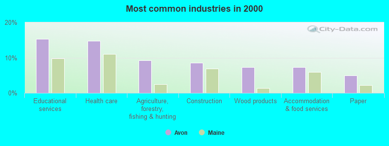
- Educational services (15.3%)
- Health care (14.7%)
- Agriculture, forestry, fishing & hunting (9.2%)
- Construction (8.6%)
- Wood products (7.4%)
- Accommodation & food services (7.4%)
- Paper (4.9%)
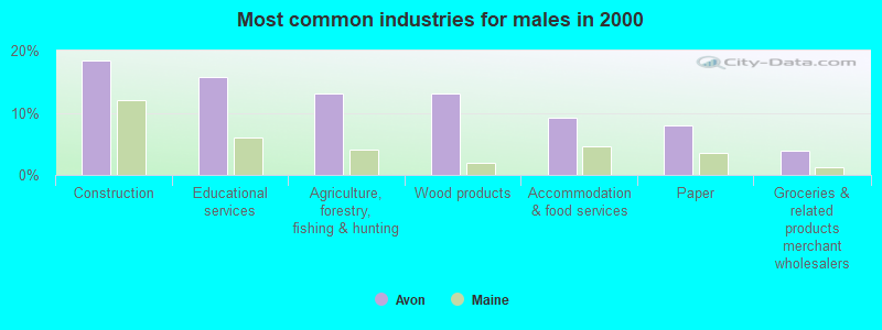
- Construction (18.4%)
- Educational services (15.8%)
- Agriculture, forestry, fishing & hunting (13.2%)
- Wood products (13.2%)
- Accommodation & food services (9.2%)
- Paper (7.9%)
- Groceries & related products merchant wholesalers (3.9%)
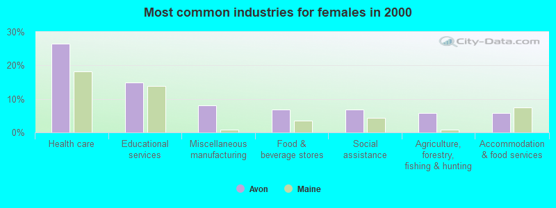
- Health care (26.4%)
- Educational services (14.9%)
- Miscellaneous manufacturing (8.0%)
- Food & beverage stores (6.9%)
- Social assistance (6.9%)
- Agriculture, forestry, fishing & hunting (5.7%)
- Accommodation & food services (5.7%)

- Preschool, kindergarten, elementary, and middle school teachers (8.6%)
- Nursing, psychiatric, and home health aides (6.7%)
- Other production occupations, including supervisors (6.7%)
- Fishing, hunting, and forestry occupations (5.5%)
- Metal workers and plastic workers (4.9%)
- Other office and administrative support workers, including supervisors (3.7%)
- Registered nurses (3.7%)

- Fishing, hunting, and forestry occupations (9.2%)
- Teachers, secondary school (7.9%)
- Metal workers and plastic workers (7.9%)
- Other production occupations, including supervisors (7.9%)
- Driver/sales workers and truck drivers (7.9%)
- Supervisors, construction and extraction workers (6.6%)
- Preschool, kindergarten, elementary, and middle school teachers (5.3%)

- Nursing, psychiatric, and home health aides (12.6%)
- Preschool, kindergarten, elementary, and middle school teachers (11.5%)
- Cooks and food preparation workers (6.9%)
- Registered nurses (6.9%)
- Health technologists and technicians (5.7%)
- Other production occupations, including supervisors (5.7%)
- Cashiers (4.6%)
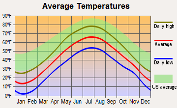
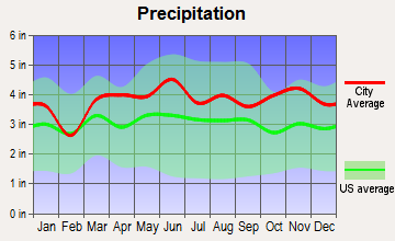
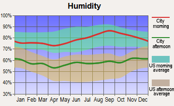
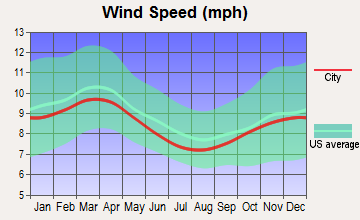
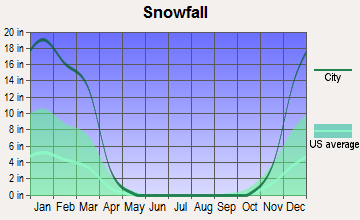
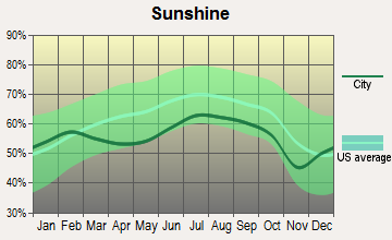
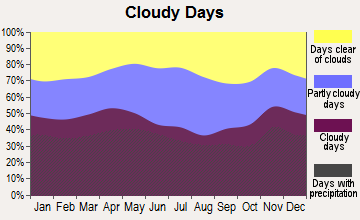
Average climate in Avon, Maine
Based on data reported by over 4,000 weather stations
(lower is better)
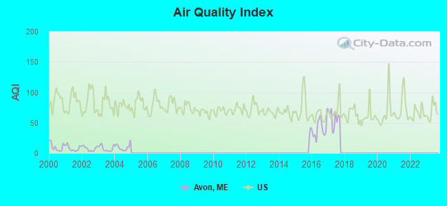
Air Quality Index (AQI) level in 2017 was 57.9. This is better than average.
| City: | 57.9 |
| U.S.: | 72.6 |
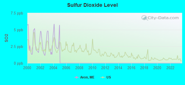
Sulfur Dioxide (SO2) [ppb] level in 2004 was 3.52. This is significantly worse than average. Closest monitor was 19.0 miles away from the city center.
| City: | 3.52 |
| U.S.: | 1.51 |
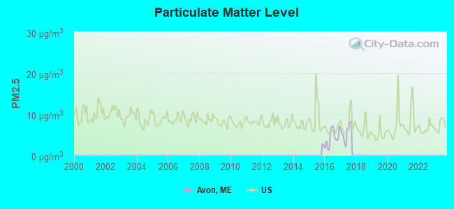
Particulate Matter (PM2.5) [µg/m3] level in 2017 was 5.59. This is significantly better than average. Closest monitor was 11.8 miles away from the city center.
| City: | 5.59 |
| U.S.: | 8.11 |
Earthquake activity:
Avon-area historical earthquake activity is significantly above Maine state average. It is 79% smaller than the overall U.S. average.On 4/20/2002 at 10:50:47, a magnitude 5.3 (5.3 ML, Depth: 3.0 mi, Class: Moderate, Intensity: VI - VII) earthquake occurred 167.1 miles away from the city center
On 4/20/2002 at 10:50:47, a magnitude 5.2 (5.2 MB, 4.2 MS, 5.2 MW, 5.0 MW) earthquake occurred 168.3 miles away from Avon center
On 10/7/1983 at 10:18:46, a magnitude 5.3 (5.1 MB, 5.3 LG, 5.1 ML) earthquake occurred 206.9 miles away from the city center
On 10/16/2012 at 23:12:25, a magnitude 4.7 (4.7 ML, Depth: 10.0 mi, Class: Light, Intensity: IV - V) earthquake occurred 84.1 miles away from the city center
On 1/19/1982 at 00:14:42, a magnitude 4.7 (4.5 MB, 4.7 MD, 4.5 LG) earthquake occurred 109.4 miles away from Avon center
On 2/26/1999 at 03:38:43, a magnitude 3.8 (3.8 LG, Depth: 2.0 mi, Class: Light, Intensity: II - III) earthquake occurred 45.0 miles away from the city center
Magnitude types: regional Lg-wave magnitude (LG), body-wave magnitude (MB), duration magnitude (MD), local magnitude (ML), surface-wave magnitude (MS), moment magnitude (MW)
Natural disasters:
The number of natural disasters in Franklin County (27) is a lot greater than the US average (15).Major Disasters (Presidential) Declared: 19
Emergencies Declared: 7
Causes of natural disasters: Floods: 16, Storms: 14, Snows: 7, Heavy Rains: 2, Hurricanes: 2, Blizzard: 1, Ice Storm: 1, Landslide: 1, Snowfall: 1, Tropical Storm: 1, Wind: 1, Winter Storm: 1, Other: 2 (Note: some incidents may be assigned to more than one category).

Airports located in Avon:
- Lindbergh Airport (08ME) (Runways: 1)
Colleges/universities with over 2000 students nearest to Avon:
- University of Maine at Farmington (about 13 miles; Farmington, ME; Full-time enrollment: 2,036)
- University of Maine at Augusta (about 41 miles; Augusta, ME; FT enrollment: 3,204)
- Saint Joseph's College of Maine (about 68 miles; Standish, ME; FT enrollment: 2,010)
- Husson University (about 76 miles; Bangor, ME; FT enrollment: 2,421)
- University of Southern Maine (about 78 miles; Portland, ME; FT enrollment: 6,647)
- Southern Maine Community College (about 80 miles; South Portland, ME; FT enrollment: 4,666)
- University of Maine (about 82 miles; Orono, ME; FT enrollment: 8,931)
Points of interest:
Cemeteries: Pease Cemetery (1), Avon Cemetery (2). Display/hide their locations on the map
Lakes: Day Mountain Pond (A), Mount Blue Pond (B). Display/hide their locations on the map
Streams, rivers, and creeks: Trask Brook (A), Dickey Brook (B), Mount Blue Stream (C). Display/hide their locations on the map
Birthplace of: Zebulon York - Confederate Army general.
| This town: | 2.1 people |
| Maine: | 2.3 people |
| This town: | 58.3% |
| Whole state: | 62.9% |
| This town: | 12.5% |
| Whole state: | 9.4% |
No gay or lesbian households reported
| This town: | 20.0% |
| Whole state: | 10.9% |
| This town: | 5.3% |
| Whole state: | 4.1% |
For population 15 years and over in Avon:
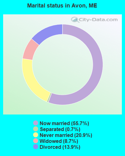
- Never married: 20.9%
- Now married: 55.7%
- Separated: 0.7%
- Widowed: 8.7%
- Divorced: 13.9%
For population 25 years and over in Avon:
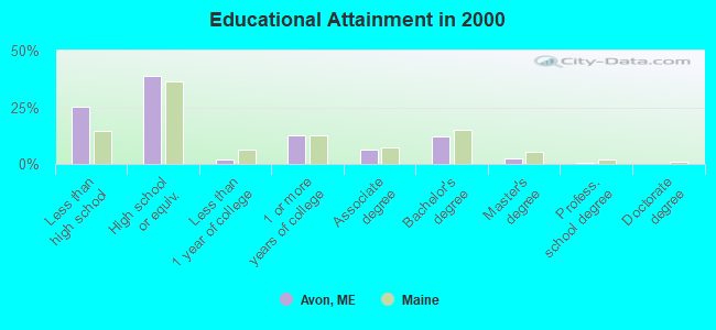
- High school or higher: 74.7%
- Bachelor's degree or higher: 15.2%
- Graduate or professional degree: 2.9%
- Unemployed: 13.3%
- Mean travel time to work (commute): 20.0 minutes
| Here: | 11.7 |
| Maine average: | 11.2 |
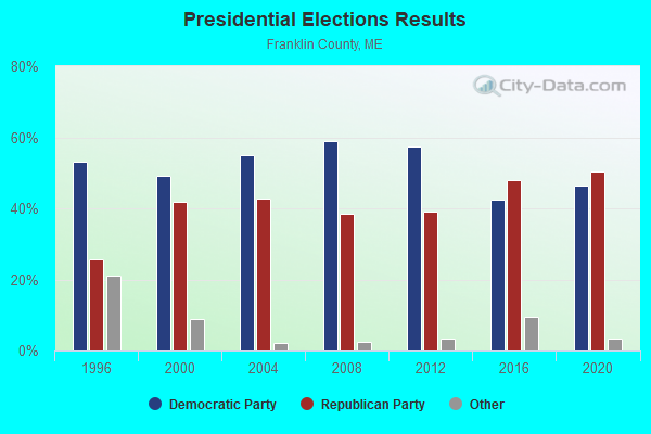
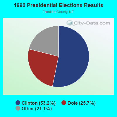
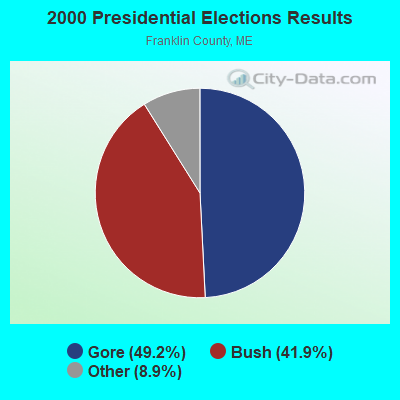


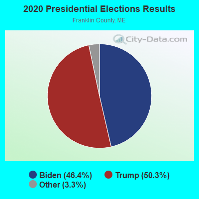
Graphs represent county-level data. Detailed 2008 Election Results
Religion statistics for Avon, ME (based on Franklin County data)
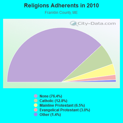
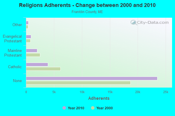
| Religion | Adherents | Congregations |
|---|---|---|
| Catholic | 3,936 | 5 |
| Mainline Protestant | 2,003 | 21 |
| Evangelical Protestant | 908 | 16 |
| Other | 427 | 2 |
| None | 23,494 | - |
Food Environment Statistics:
| Franklin County: | 4.68 / 10,000 pop. |
| Maine: | 2.80 / 10,000 pop. |
| This county: | 0.33 / 10,000 pop. |
| State: | 0.14 / 10,000 pop. |
| Franklin County: | 3.01 / 10,000 pop. |
| Maine: | 2.20 / 10,000 pop. |
| Franklin County: | 6.69 / 10,000 pop. |
| State: | 5.75 / 10,000 pop. |
| Here: | 14.38 / 10,000 pop. |
| State: | 11.02 / 10,000 pop. |
| This county: | 7.3% |
| Maine: | 8.2% |
| Franklin County: | 24.4% |
| Maine: | 25.0% |
Strongest AM radio stations in Avon:
- WTME (780 AM; 10 kW; RUMFORD, ME; Owner: MOUNTAIN VALLEY BROADCASTING, INC.)
- WSKW (1160 AM; 10 kW; SKOWHEGAN, ME; Owner: MOUNTAIN WIRELESS, INCORPORATED)
- WRKO (680 AM; 50 kW; BOSTON, MA; Owner: ENTERCOM BOSTON LICENSE, LLC)
- WFAU (1280 AM; 5 kW; GARDINER, ME; Owner: CAPSTAR TX LIMITED PARTNERSHIP)
- WCHP (760 AM; 35 kW; CHAMPLAIN, NY; Owner: CHAMPLAIN RADIO, INC.)
- WMTW (870 AM; 10 kW; GORHAM, ME; Owner: RADIO PARTNERS OF MAINE, L.P.)
- WEEI (850 AM; 50 kW; BOSTON, MA; Owner: ENTERCOM BOSTON LICENSE, LLC)
- WCRN (830 AM; 50 kW; WORCESTER, MA; Owner: CARTER BROADCASTING CORPORATION)
- WBZ (1030 AM; 50 kW; BOSTON, MA; Owner: INFINITY BROADCASTING OPERATIONS, INC.)
- WNNZ (640 AM; 50 kW; WESTFIELD, MA; Owner: CLEAR CHANNEL BROADCASTING LICENSES, INC.)
- WGAN (560 AM; 5 kW; PORTLAND, ME; Owner: SAGA COMMUNICATIONS OF NEW ENGLAND, LLC)
- WLAM (1470 AM; 5 kW; LEWISTON, ME; Owner: RADIO PARTNERS OF MAINE, L.P.)
- WZON (620 AM; 5 kW; BANGOR, ME; Owner: THE ZONE CORPORATION)
Strongest FM radio stations in Avon:
- WTOS-FM (105.1 FM; SKOWHEGAN, ME; Owner: CAPSTAR TX LIMITED PARTNERSHIP)
- WLOB-FM (96.3 FM; RUMFORD, ME; Owner: ATLANTIC COAST RADIO, LLC)
- WTBM (100.7 FM; MEXICO, ME; Owner: MOUNTAIN VALLEY BROADCASTING, INC.)
- WPKQ (103.7 FM; NORTH CONWAY, NH; Owner: CITADEL BROADCASTING COMPANY)
- WKTJ-FM (99.3 FM; FARMINGTON, ME; Owner: FRANKLIN BROADCASTING CORPORATION)
- WHOM (94.9 FM; MT. WASHINGTON, NH; Owner: CITADEL BROADCASTING COMPANY)
- WHQO (107.9 FM; SKOWHEGAN, ME; Owner: MOUNTAIN WIRELESS, INC.)
- WIGY (97.5 FM; MADISON, ME; Owner: CAPSTAR TX LIMITED PARTNERSHIP)
TV broadcast stations around Avon:
- W21BI (Channel 21; FARMINGTON, ME; Owner: TRINITY BROADCASTING NETWORK)
- National Bridge Inventory (NBI) Statistics
- 3Number of bridges
- 13ft / 3.5mTotal length
- 5,124Total average daily traffic
- 255Total average daily truck traffic
- 7,259Total future (year 2036) average daily traffic
FCC Registered Microwave Towers:
1- MT BLUE, Top Of Mt Blue, Mt Blue State Park (Lat: 44.728111 Lon: -70.342000), Type: Building, Structure height: 16.8 m, Call Sign: WQNM773,
Assigned Frequencies: 942.575 MHz, 942.975 MHz, 6805.00 MHz, 6855.00 MHz, 6805.00 MHz, 6855.00 MHz, 6805.00 MHz, 6855.00 MHz, 6805.00 MHz, 6855.00 MHz... (+10 more), Grant Date: 01/29/2021, Expiration Date: 03/25/2031, Certifier: David E Mars, Registrant: State Of Maine, O.I.T., Radio Operations, 66 Industrial Drive, Augusta, ME 04333-0147, Phone: (207) 624-9990, Email:
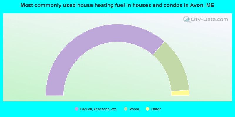
- 72.7%Fuel oil, kerosene, etc.
- 24.8%Wood
- 1.2%Bottled, tank, or LP gas
- 1.2%Electricity
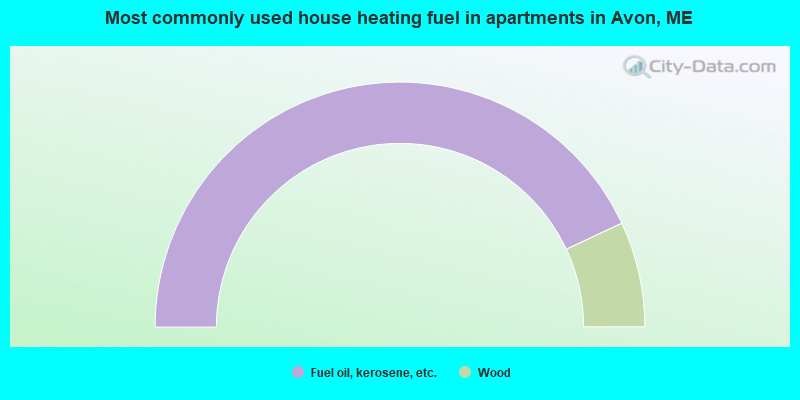
- 86.1%Fuel oil, kerosene, etc.
- 13.9%Wood
Avon compared to Maine state average:
- Median house value below state average.
- Black race population percentage below state average.
- Hispanic race population percentage below state average.
- Foreign-born population percentage significantly below state average.
- Length of stay since moving in significantly above state average.
- Number of rooms per house significantly below state average.
- House age significantly below state average.
- Percentage of population with a bachelor's degree or higher below state average.