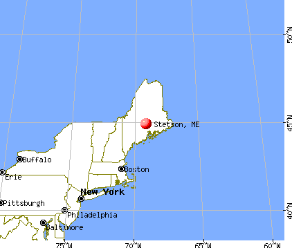
Stetson, Maine
Submit your own pictures of this town and show them to the world
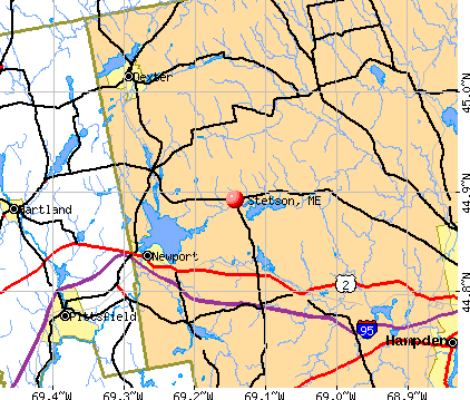
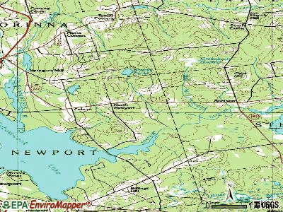
- OSM Map
- General Map
- Google Map
- MSN Map
Population change since 2000: +22.5%
| Males: 601 | |
| Females: 601 |
| Median resident age: | 41.6 years |
| Maine median age: | 43.0 years |
Zip codes: 04488.
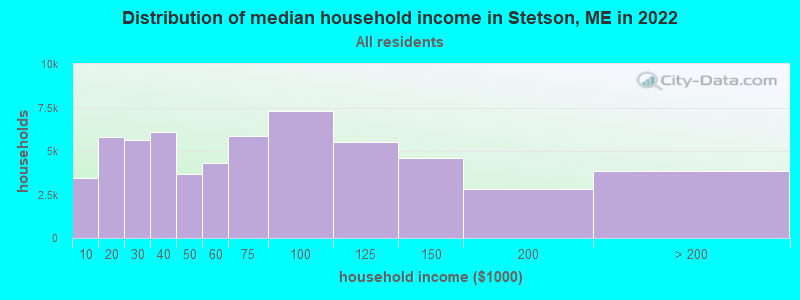
| Stetson: | $54,591 |
| ME: | $69,543 |
Estimated per capita income in 2022: $27,392 (it was $13,626 in 2000)
Stetson town income, earnings, and wages data
Estimated median house or condo value in 2022: $184,226 (it was $70,800 in 2000)
| Stetson: | $184,226 |
| ME: | $290,600 |
Mean prices in 2022: all housing units: $235,563; detached houses: $252,705; townhouses or other attached units: $267,749; in 2-unit structures: $255,332; in 3-to-4-unit structures: $815,300; in 5-or-more-unit structures: $185,873; mobile homes: $93,017; occupied boats, rvs, vans, etc.: $21,333
Detailed information about poverty and poor residents in Stetson, ME


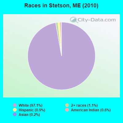
- 1,16797.1%White alone
- 131.1%Two or more races
- 110.9%Hispanic
- 70.6%American Indian alone
- 30.2%Asian alone
- 10.08%Black alone
Races in Stetson detailed stats: ancestries, foreign born residents, place of birth
According to our research of Maine and other state lists, there were 2 registered sex offenders living in Stetson, Maine as of May 08, 2024.
The ratio of all residents to sex offenders in Stetson is 601 to 1.
The ratio of registered sex offenders to all residents in this city is near the state average.
 Recent articles from our blog. Our writers, many of them Ph.D. graduates or candidates, create easy-to-read articles on a wide variety of topics.

 | Maine weather thread (3207 replies) |
| Looking to move outside Bangor with kids (6 replies) |
| Emmc (41 replies) |
| New Wind Farm For Lincoln Area (60 replies) |
| To Eat and To Drink on My Visit... (16 replies) |
| whats the actual locate vs. relocate number? (20 replies) |
Latest news from Stetson, ME collected exclusively by city-data.com from local newspapers, TV, and radio stations
Ancestries: United States (22.5%), English (15.4%), Irish (13.9%), French (12.3%), Scottish (5.3%), Italian (4.4%).
Current Local Time: EST time zone
Incorporated on 01/28/1831
Elevation: 225 feet
Land area: 34.9 square miles.
Population density: 34 people per square mile (very low).
21 residents are foreign born (1.1% North America, 0.8% Europe).
| This town: | 2.1% |
| Maine: | 2.9% |
| Stetson town: | 1.2% ($865) |
| Maine: | 1.5% ($1,417) |
Nearest city with pop. 50,000+: Portland, ME  (101.0 miles , pop. 64,249).
Nearest city with pop. 200,000+: Boston, MA (202.1 miles , pop. 589,141).
Nearest city with pop. 1,000,000+: Bronx, NY (368.1 miles , pop. 1,332,650).
Nearest cities:
), ), ), )Latitude: 44.87 N, Longitude: 69.12 W
Area code: 207

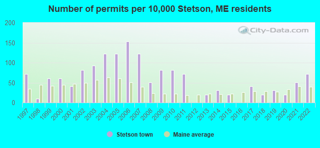
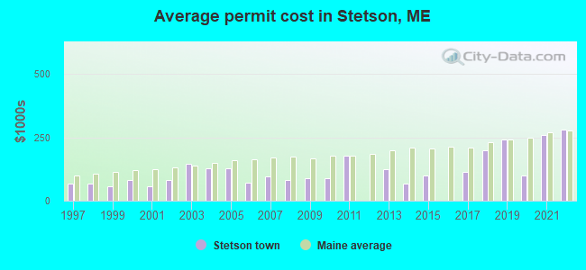
Single-family new house construction building permits:
- 2022: 7 buildings, average cost: $279,200
- 2021: 5 buildings, average cost: $259,200
- 2020: 2 buildings, average cost: $100,000
- 2019: 3 buildings, average cost: $241,700
- 2018: 2 buildings, average cost: $200,000
- 2017: 4 buildings, average cost: $112,500
- 2015: 2 buildings, average cost: $100,000
- 2014: 3 buildings, average cost: $66,700
- 2013: 2 buildings, average cost: $125,000
- 2011: 7 buildings, average cost: $178,600
- 2010: 8 buildings, average cost: $87,100
- 2009: 8 buildings, average cost: $87,100
- 2008: 5 buildings, average cost: $80,700
- 2007: 12 buildings, average cost: $95,600
- 2006: 15 buildings, average cost: $70,000
- 2005: 12 buildings, average cost: $126,700
- 2004: 12 buildings, average cost: $126,700
- 2003: 9 buildings, average cost: $143,900
- 2002: 8 buildings, average cost: $83,100
- 2001: 4 buildings, average cost: $56,300
- 2000: 6 buildings, average cost: $82,000
- 1999: 6 buildings, average cost: $58,300
- 1998: 1 building, cost: $67,000
- 1997: 7 buildings, average cost: $68,000
| Here: | 3.3% |
| Maine: | 3.4% |
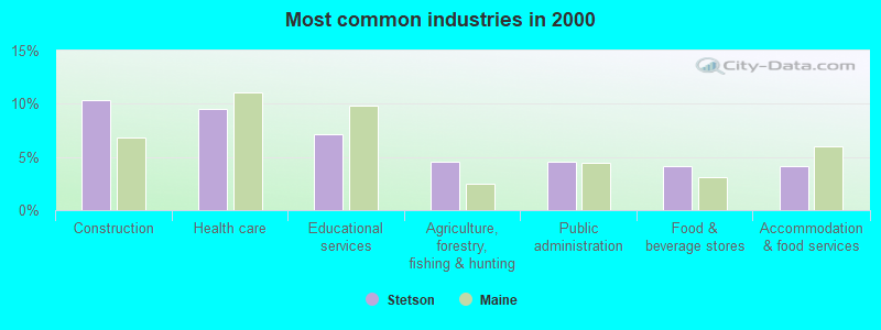
- Construction (10.4%)
- Health care (9.5%)
- Educational services (7.1%)
- Agriculture, forestry, fishing & hunting (4.5%)
- Public administration (4.5%)
- Food & beverage stores (4.1%)
- Accommodation & food services (4.1%)
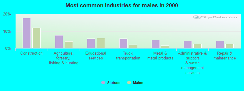
- Construction (17.7%)
- Agriculture, forestry, fishing & hunting (7.7%)
- Educational services (5.6%)
- Truck transportation (5.6%)
- Metal & metal products (4.8%)
- Administrative & support & waste management services (4.4%)
- Repair & maintenance (4.4%)
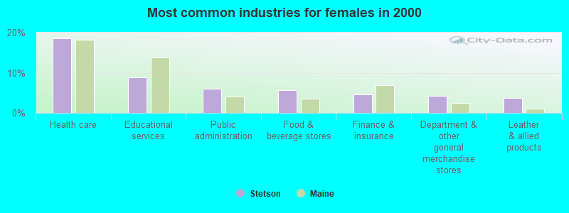
- Health care (18.6%)
- Educational services (8.8%)
- Public administration (6.0%)
- Food & beverage stores (5.6%)
- Finance & insurance (4.7%)
- Department & other general merchandise stores (4.2%)
- Leather & allied products (3.7%)

- Other production occupations, including supervisors (5.4%)
- Driver/sales workers and truck drivers (5.2%)
- Other sales and related occupations, including supervisors (5.0%)
- Building and grounds cleaning and maintenance occupations (3.7%)
- Other teachers, instructors, education, training, and library occupations (3.5%)
- Construction traders workers except carpenters, electricians, painters, plumbers, and construction laborers (3.5%)
- Metal workers and plastic workers (3.5%)

- Driver/sales workers and truck drivers (8.1%)
- Other sales and related occupations, including supervisors (8.1%)
- Other production occupations, including supervisors (7.3%)
- Construction traders workers except carpenters, electricians, painters, plumbers, and construction laborers (6.5%)
- Carpenters (5.6%)
- Metal workers and plastic workers (4.8%)
- Fishing, hunting, and forestry occupations (4.4%)

- Other teachers, instructors, education, training, and library occupations (6.0%)
- Cashiers (6.0%)
- Building and grounds cleaning and maintenance occupations (5.6%)
- Information and record clerks, except customer service representatives (4.7%)
- Waiters and waitresses (4.2%)
- Nursing, psychiatric, and home health aides (4.2%)
- Secretaries and administrative assistants (4.2%)
Average climate in Stetson, Maine
Based on data reported by over 4,000 weather stations


(lower is better)
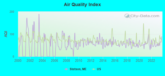
Air Quality Index (AQI) level in 2023 was 61.1. This is about average.
| City: | 61.1 |
| U.S.: | 72.6 |
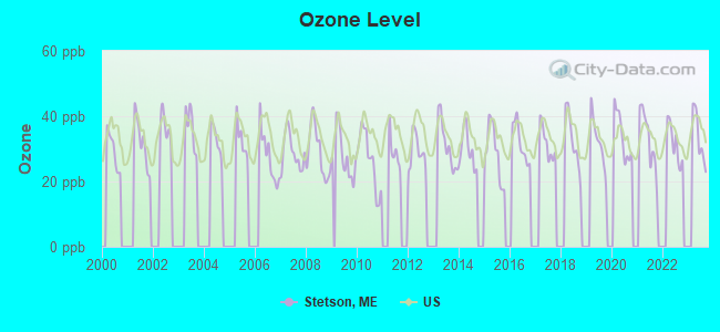
Ozone [ppb] level in 2023 was 33.6. This is about average. Closest monitor was 11.7 miles away from the city center.
| City: | 33.6 |
| U.S.: | 33.3 |
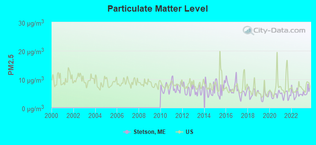
Particulate Matter (PM2.5) [µg/m3] level in 2023 was 5.62. This is significantly better than average. Closest monitor was 17.3 miles away from the city center.
| City: | 5.62 |
| U.S.: | 8.11 |
Earthquake activity:
Stetson-area historical earthquake activity is significantly above Maine state average. It is 81% smaller than the overall U.S. average.On 4/20/2002 at 10:50:47, a magnitude 5.3 (5.3 ML, Depth: 3.0 mi, Class: Moderate, Intensity: VI - VII) earthquake occurred 226.5 miles away from the city center
On 10/16/2012 at 23:12:25, a magnitude 4.7 (4.7 ML, Depth: 10.0 mi, Class: Light, Intensity: IV - V) earthquake occurred 116.5 miles away from the city center
On 4/20/2002 at 10:50:47, a magnitude 5.2 (5.2 MB, 4.2 MS, 5.2 MW, 5.0 MW) earthquake occurred 227.8 miles away from the city center
On 10/7/1983 at 10:18:46, a magnitude 5.3 (5.1 MB, 5.3 LG, 5.1 ML) earthquake occurred 265.8 miles away from Stetson center
On 1/19/1982 at 00:14:42, a magnitude 4.7 (4.5 MB, 4.7 MD, 4.5 LG) earthquake occurred 155.4 miles away from Stetson center
On 2/26/1999 at 03:38:43, a magnitude 3.8 (3.8 LG, Depth: 2.0 mi, Class: Light, Intensity: II - III) earthquake occurred 33.5 miles away from Stetson center
Magnitude types: regional Lg-wave magnitude (LG), body-wave magnitude (MB), duration magnitude (MD), local magnitude (ML), surface-wave magnitude (MS), moment magnitude (MW)
Natural disasters:
The number of natural disasters in Penobscot County (19) is greater than the US average (15).Major Disasters (Presidential) Declared: 11
Emergencies Declared: 7
Causes of natural disasters: Floods: 9, Storms: 8, Snows: 5, Heavy Rains: 2, Blizzard: 1, Hurricane: 1, Ice Storm: 1, Snowfall: 1, Wind: 1, Winter Storm: 1, Other: 2 (Note: some incidents may be assigned to more than one category).
Hospitals and medical centers near Stetson:
- SQUARE ROAD GROUP HOME (Hospital, about 11 miles away; SAINT ALBANS, ME)
- PITTSFIELD REHAB AND NURSING (Nursing Home, about 14 miles away; PITTSFIELD, ME)
- BIRCH GROVE REHAB AND LIVING CTR (Nursing Home, about 14 miles away; PITTSFIELD, ME)
- DEXTER HEALTH CARE (Nursing Home, about 14 miles away; DEXTER, ME)
- SEBASTICOOK VALLEY HOSPITAL Critical Access Hospitals (about 14 miles away; PITTSFIELD, ME)
- BANGOR AREA VISITING NURSES (Home Health Center, about 16 miles away; BANGOR, ME)
- HOSPICE OF EASTERN MAINE (Hospital, about 16 miles away; BANGOR, ME)
Colleges/universities with over 2000 students nearest to Stetson:
- Husson University (about 17 miles; Bangor, ME; Full-time enrollment: 2,421)
- University of Maine (about 22 miles; Orono, ME; FT enrollment: 8,931)
- University of Maine at Augusta (about 50 miles; Augusta, ME; FT enrollment: 3,204)
- University of Maine at Farmington (about 53 miles; Farmington, ME; FT enrollment: 2,036)
- Saint Joseph's College of Maine (about 99 miles; Standish, ME; FT enrollment: 2,010)
- Southern Maine Community College (about 101 miles; South Portland, ME; FT enrollment: 4,666)
- University of Southern Maine (about 102 miles; Portland, ME; FT enrollment: 6,647)
Private high school in Stetson:
Public elementary/middle school in Stetson:
- STETSON ELEMENTARY SCHOOL (Location: 394 VILLAGE ROAD, Grades: KG-2)
Points of interest:
Notable locations in Stetson: Pleasant Lake Shores Campground (A), Stetson Volunteer Fire Department (B). Display/hide their locations on the map
Churches in Stetson include: First Baptist Church (A), Union Church (B). Display/hide their locations on the map
Cemeteries: Mount Pleasant Cemetery (1), Clark Hill Cemetery (2), Coboro Cemetery (3). Display/hide their locations on the map
Lakes and reservoirs: Lost Pond (A), Mud Pond (B), Pleasant Lake (C). Display/hide their locations on the map
Streams, rivers, and creeks: Buzzell Stream (A). Display/hide its location on the map
Birthplace of: Mark L. Hersey - Army general.
Drinking water stations with addresses in Stetson and their reported violations in the past:
STETSON SHORE CAMPGROUND (Population served: 108, Groundwater):Past health violations:
- MCL, Monthly (TCR) - In JUN-2012, Contaminant: Coliform. Follow-up actions: St Public Notif requested (JUN-21-2012), St Formal NOV issued (JUN-21-2012), St Public Notif received (JUL-10-2012), St Compliance achieved (JUL-18-2012)
- MCL, Monthly (TCR) - In MAY-2012, Contaminant: Coliform. Follow-up actions: St Public Notif requested (JUN-21-2012), St Formal NOV issued (JUN-21-2012), St Public Notif received (JUL-10-2012), St Compliance achieved (JUL-18-2012)
Drinking water stations with addresses in Stetson that have no violations reported:
- CORINTHIAN MANOR (Population served: 60, Primary Water Source Type: Groundwater)
| This town: | 2.5 people |
| Maine: | 2.3 people |
| This town: | 71.8% |
| Whole state: | 62.9% |
| This town: | 10.2% |
| Whole state: | 9.4% |
Likely homosexual households (counted as self-reported same-sex unmarried-partner households)
- Lesbian couples: 1.3% of all households
- Gay men: 0.8% of all households
| This town: | 17.5% |
| Whole state: | 10.9% |
| This town: | 6.3% |
| Whole state: | 4.1% |
For population 15 years and over in Stetson:
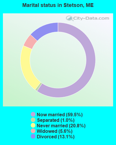
- Never married: 20.8%
- Now married: 59.5%
- Separated: 1.0%
- Widowed: 5.6%
- Divorced: 13.1%
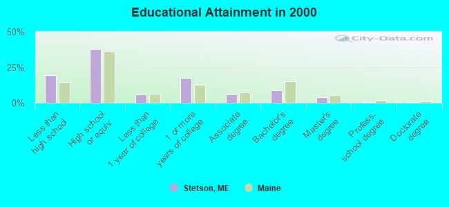
For population 25 years and over in Stetson:
- High school or higher: 80.4%
- Bachelor's degree or higher: 13.0%
- Graduate or professional degree: 4.4%
- Unemployed: 5.3%
- Mean travel time to work (commute): 35.0 minutes
| Here: | 10.9 |
| Maine average: | 11.2 |


Graphs represent county-level data. Detailed 2008 Election Results
Religion statistics for Stetson, ME (based on Penobscot County data)


| Religion | Adherents | Congregations |
|---|---|---|
| Catholic | 16,581 | 15 |
| Mainline Protestant | 9,715 | 59 |
| Evangelical Protestant | 7,523 | 80 |
| Other | 2,936 | 22 |
| Orthodox | 300 | 1 |
| None | 116,868 | - |
Food Environment Statistics:
| This county: | 2.29 / 10,000 pop. |
| State: | 2.80 / 10,000 pop. |
| This county: | 0.13 / 10,000 pop. |
| Maine: | 0.14 / 10,000 pop. |
| Here: | 2.56 / 10,000 pop. |
| Maine: | 2.20 / 10,000 pop. |
| This county: | 5.72 / 10,000 pop. |
| Maine: | 5.75 / 10,000 pop. |
| This county: | 7.41 / 10,000 pop. |
| Maine: | 11.02 / 10,000 pop. |
| Here: | 9.0% |
| State: | 8.2% |
| This county: | 28.0% |
| State: | 25.0% |
Strongest AM radio stations in Stetson:
- WZON (620 AM; 5 kW; BANGOR, ME; Owner: THE ZONE CORPORATION)
- WABI (910 AM; 5 kW; BANGOR, ME; Owner: CLEAR CHANNEL BROADCASTING LICENSES, INC.)
- WSKW (1160 AM; 10 kW; SKOWHEGAN, ME; Owner: MOUNTAIN WIRELESS, INCORPORATED)
- WTME (780 AM; 10 kW; RUMFORD, ME; Owner: MOUNTAIN VALLEY BROADCASTING, INC.)
- WDEA (1370 AM; 5 kW; ELLSWORTH, ME; Owner: CUMULUS LICENSING CORP.)
- WRKO (680 AM; 50 kW; BOSTON, MA; Owner: ENTERCOM BOSTON LICENSE, LLC)
- WNZS (1340 AM; 1 kW; VEAZIE, ME; Owner: WATERFRONT COMMUNICATIONS INC.)
- WEEI (850 AM; 50 kW; BOSTON, MA; Owner: ENTERCOM BOSTON LICENSE, LLC)
- WFAU (1280 AM; 5 kW; GARDINER, ME; Owner: CAPSTAR TX LIMITED PARTNERSHIP)
- WBZ (1030 AM; 50 kW; BOSTON, MA; Owner: INFINITY BROADCASTING OPERATIONS, INC.)
- WCRN (830 AM; 50 kW; WORCESTER, MA; Owner: CARTER BROADCASTING CORPORATION)
- WNNZ (640 AM; 50 kW; WESTFIELD, MA; Owner: CLEAR CHANNEL BROADCASTING LICENSES, INC.)
- WCHP (760 AM; 35 kW; CHAMPLAIN, NY; Owner: CHAMPLAIN RADIO, INC.)
Strongest FM radio stations in Stetson:
- WWBX (97.1 FM; BANGOR, ME; Owner: CLEAR CHANNEL BROADCASTING LICENSES, INC.)
- WQCB (106.5 FM; BREWER, ME; Owner: CUMULUS LICENSING CORP.)
- WGUY (102.1 FM; DEXTER, ME; Owner: CONCORD MEDIA GROUP, INC.)
- WBFB (104.7 FM; BELFAST, ME; Owner: CLEAR CHANNEL BROADCASTING LICENSES, INC.)
- WJCX (99.5 FM; PITTSFIELD, ME; Owner: CSN INTERNATIONAL)
- WKIT-FM (100.3 FM; BREWER, ME; Owner: THE ZONE CORPORATION)
- WVOM (103.9 FM; HOWLAND, ME; Owner: CLEAR CHANNEL BROADCASTING LICENSES, INC.)
- WWMJ (95.7 FM; ELLSWORTH, ME; Owner: CUMULUS LICENSING CORP.)
- WHCF (88.5 FM; BANGOR, ME; Owner: BANGOR BAPTIST CHURCH)
- WTOS-FM (105.1 FM; SKOWHEGAN, ME; Owner: CAPSTAR TX LIMITED PARTNERSHIP)
- WBZN (107.3 FM; OLD TOWN, ME; Owner: CUMULUS LICENSING CORP.)
- WMEH (90.9 FM; BANGOR, ME; Owner: MAINE PUBLIC BROADCASTING CORPORATION)
- WFZX (101.7 FM; SEARSPORT, ME; Owner: CLEAR CHANNEL BROADCASTING LICENSES, INC.)
- WEZQ (92.9 FM; BANGOR, ME; Owner: CUMULUS LICENSING CORP.)
- WMEP (90.5 FM; CAMDEN, ME; Owner: MAINE PUBLIC BROADCASTING CORP.)
- WQSS (102.5 FM; CAMDEN, ME; Owner: CLEAR CHANNEL BROADCASTING LICENSES, INC.)
- WCTB (93.5 FM; FAIRFIELD, ME; Owner: MOUNTAIN WIRELESS, INC.)
- WHQO (107.9 FM; SKOWHEGAN, ME; Owner: MOUNTAIN WIRELESS, INC.)
- WERU-FM (89.9 FM; BLUE HILL, ME; Owner: SALT POND COMMUNITY B/C COMPANY)
- WDME-FM (103.1 FM; DOVER-FOXCROFT, ME; Owner: THE ZONE CORPORATION)
TV broadcast stations around Stetson:
- WABI-TV (Channel 5; BANGOR, ME; Owner: COMMUNITY BROADCASTING SERVICE)
- W36CK (Channel 36; BANGOR, ME; Owner: TRINITY BROADCASTING NETWORK)
- WCKD-LP (Channel 30; BANGOR/DEDHAM, ME; Owner: J. MCLEOD, ME FAMILY B/CING., INC.)
- WMEB-TV (Channel 12; ORONO, ME; Owner: MAINE PUBLIC BROADCASTING CORPORATION)
- WBGR-LP (Channel 33; BANGOR/DEDHAM, ME; Owner: MAINE FAMILY BROADCASTING, INC.)
Stetson fatal accident list:
Jul 25, 2012 05:18 PM, Us-143, Mt. Pleasant Road, Lat: 44.864706, Lon: -69.126128, Vehicles: 2, Persons: 4, Fatalities: 2
Nov 8, 2009 03:20 AM, East Newport Road, Lat: 44.853922, Lon: -69.168033, Vehicles: 1, Persons: 1, Fatalities: 1, Drunk persons involved: 1
Aug 15, 2005 01:20 PM, Lakins Road, Lat: 44.875260, Lon: -69.134190, Vehicles: 1, Persons: 1, Fatalities: 1
Nov 23, 2002 10:00 PM, Stetson Road, Vehicles: 1, Persons: 3, Fatalities: 1, Drunk persons involved: 1
Oct 10, 1999 04:55 PM, Sr-222, Vehicles: 2, Persons: 6, Fatalities: 1
Oct 22, 1989 01:50 AM, 51415142, Vehicles: 1, Persons: 2, Fatalities: 1, Drunk persons involved: 1
FCC Registered Amateur Radio Licenses:
8 (See the full list of FCC Registered Amateur Radio Licenses in Stetson)FAA Registered Aircraft:
1- Aircraft: PAYNE DAVID N HORIZON 1 (Category: Land, Seats: 2, Weight: Up to 12,499 Pounds), Engine: Reciprocating
N-Number: 124LG, N124LG, N-124LG, Serial Number: H046, Certificate Issue Date: 07/20/2020
Registrant (Individual): Wayne L Allard, 857 Mount Pleasant Rd, Stetson, ME 04488
2003 - 2018 National Fire Incident Reporting System (NFIRS) incidents
- Fire incident types reported to NFIRS in Stetson, ME
- 5950.9%Structure Fires
- 4236.2%Outside Fires
- 1311.2%Mobile Property/Vehicle Fires
- 21.7%Other
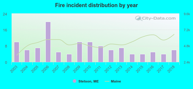 Based on the data from the years 2003 - 2018 the average number of fires per year is 7. The highest number of reported fires - 20 took place in 2006, and the least - 4 in 2008. The data has a decreasing trend.
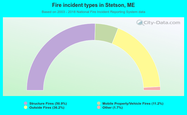 When looking into fire subcategories, the most reports belonged to: Structure Fires (50.9%), and Outside Fires (36.2%).
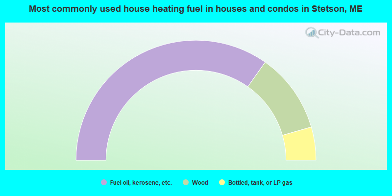
- 69.5%Fuel oil, kerosene, etc.
- 21.5%Wood
- 8.9%Bottled, tank, or LP gas
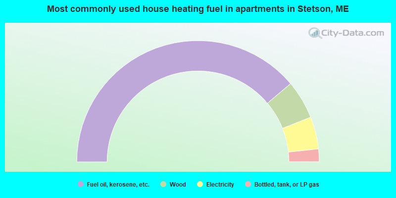
- 77.6%Fuel oil, kerosene, etc.
- 10.3%Wood
- 8.6%Electricity
- 3.4%Bottled, tank, or LP gas
Stetson compared to Maine state average:
- Median house value below state average.
- Unemployed percentage below state average.
- Black race population percentage significantly below state average.
- Hispanic race population percentage below state average.
- Foreign-born population percentage below state average.
- Renting percentage significantly below state average.
- Length of stay since moving in significantly above state average.
- Number of rooms per house significantly below state average.
- House age significantly below state average.
- Percentage of population with a bachelor's degree or higher below state average.