Exeter, Maine
Submit your own pictures of this town and show them to the world
- OSM Map
- Google Map
- MSN Map
Population change since 2000: +9.5%
 |
| Males: 531 | |
| Females: 561 |
| Median resident age: | 44.0 years |
| Maine median age: | 43.0 years |
Zip codes: 04435.
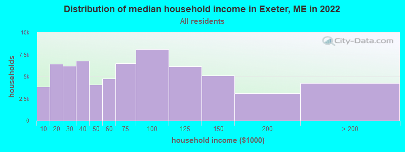
| Exeter: | $60,519 |
| ME: | $69,543 |
Estimated per capita income in 2022: $29,696 (it was $14,772 in 2000)
Exeter town income, earnings, and wages data
Estimated median house or condo value in 2022: $168,354 (it was $64,700 in 2000)
| Exeter: | $168,354 |
| ME: | $290,600 |
Mean prices in 2022: all housing units: $235,563; detached houses: $252,705; townhouses or other attached units: $267,749; in 2-unit structures: $255,332; in 3-to-4-unit structures: $815,300; in 5-or-more-unit structures: $185,873; mobile homes: $93,017; occupied boats, rvs, vans, etc.: $21,333
Detailed information about poverty and poor residents in Exeter, ME


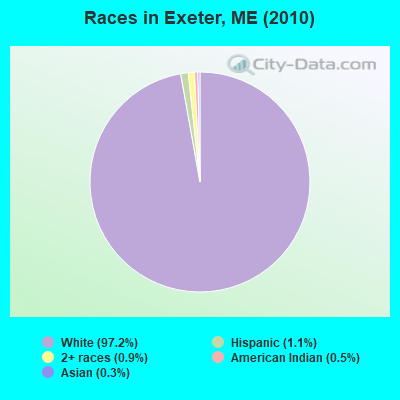
- 1,06197.2%White alone
- 121.1%Hispanic
- 100.9%Two or more races
- 60.5%American Indian alone
- 30.3%Asian alone
Races in Exeter detailed stats: ancestries, foreign born residents, place of birth
According to our research of Maine and other state lists, there were 3 registered sex offenders living in Exeter, Maine as of May 08, 2024.
The ratio of all residents to sex offenders in Exeter is 364 to 1.
 Recent articles from our blog. Our writers, many of them Ph.D. graduates or candidates, create easy-to-read articles on a wide variety of topics.
Ancestries: United States (23.8%), English (13.5%), Irish (11.0%), French (8.9%), German (6.7%), French Canadian (2.7%).
Current Local Time: EST time zone
Incorporated on 02/16/1811
Land area: 38.4 square miles.
Population density: 28 people per square mile (very low).
12 residents are foreign born
| This town: | 1.2% |
| Maine: | 2.9% |
| Exeter town: | 1.2% ($791) |
| Maine: | 1.5% ($1,417) |
Nearest city with pop. 50,000+: Portland, ME  (106.1 miles , pop. 64,249).
Nearest city with pop. 200,000+: Boston, MA (207.5 miles , pop. 589,141).
Nearest city with pop. 1,000,000+: Bronx, NY (372.6 miles , pop. 1,332,650).
Nearest cities:
), ), ), )Latitude: 44.96 N, Longitude: 69.12 W
Area code: 207
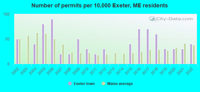
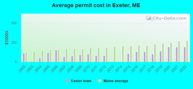
Single-family new house construction building permits:
- 2022: 4 buildings, average cost: $190,000
- 2021: 3 buildings, average cost: $190,000
- 2020: 3 buildings, average cost: $190,000
- 2019: 3 buildings, average cost: $136,700
- 2018: 6 buildings, average cost: $100,000
- 2017: 7 buildings, average cost: $129,100
- 2016: 7 buildings, average cost: $129,100
- 2015: 4 buildings, average cost: $107,000
- 2012: 3 buildings, average cost: $81,700
- 2011: 2 buildings, average cost: $80,000
- 2010: 3 buildings, average cost: $100,000
- 2009: 5 buildings, average cost: $92,000
- 2008: 2 buildings, average cost: $76,400
- 2007: 2 buildings, average cost: $65,000
- 2006: 9 buildings, average cost: $151,700
- 2005: 8 buildings, average cost: $118,100
- 2004: 4 buildings, average cost: $50,000
- 2002: 5 buildings, average cost: $110,000
| Here: | 3.7% |
| Maine: | 3.4% |
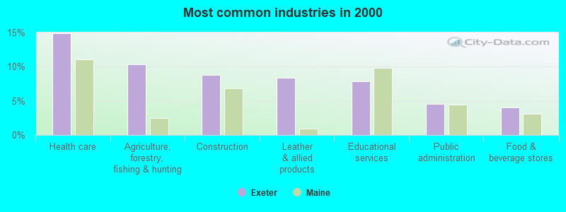
- Health care (14.9%)
- Agriculture, forestry, fishing & hunting (10.4%)
- Construction (8.8%)
- Leather & allied products (8.3%)
- Educational services (7.9%)
- Public administration (4.5%)
- Food & beverage stores (4.1%)
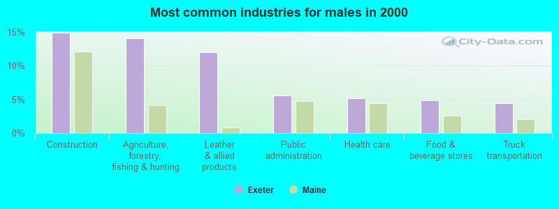
- Construction (14.9%)
- Agriculture, forestry, fishing & hunting (14.1%)
- Leather & allied products (12.0%)
- Public administration (5.6%)
- Health care (5.2%)
- Food & beverage stores (4.8%)
- Truck transportation (4.4%)
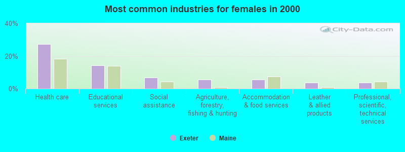
- Health care (27.2%)
- Educational services (14.4%)
- Social assistance (6.7%)
- Agriculture, forestry, fishing & hunting (5.6%)
- Accommodation & food services (5.6%)
- Leather & allied products (3.6%)
- Professional, scientific, technical services (3.6%)

- Agricultural workers, including supervisors (4.7%)
- Farmers and farm managers (3.8%)
- Other production occupations, including supervisors (3.6%)
- Building and grounds cleaning and maintenance occupations (3.6%)
- Other sales and related occupations, including supervisors (3.4%)
- Laborers and material movers, hand (3.4%)
- Driver/sales workers and truck drivers (3.4%)
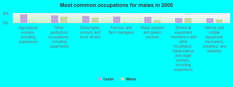
- Agricultural workers, including supervisors (7.6%)
- Other production occupations, including supervisors (6.4%)
- Driver/sales workers and truck drivers (6.0%)
- Farmers and farm managers (5.6%)
- Metal workers and plastic workers (5.2%)
- Electrical equipment mechanics and other installation, maintenance, and repair workers, including supervisors (4.4%)
- Vehicle and mobile equipment mechanics, installers, and repairers (4.0%)

- Secretaries and administrative assistants (7.2%)
- Other office and administrative support workers, including supervisors (6.7%)
- Registered nurses (5.6%)
- Preschool, kindergarten, elementary, and middle school teachers (5.1%)
- Other sales and related occupations, including supervisors (4.6%)
- Building and grounds cleaning and maintenance occupations (4.1%)
- Other teachers, instructors, education, training, and library occupations (3.6%)
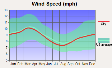
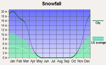
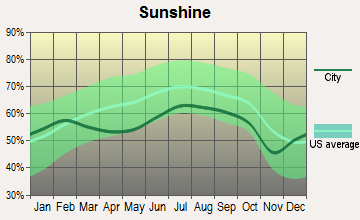
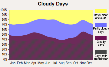
Average climate in Exeter, Maine
Based on data reported by over 4,000 weather stations
(lower is better)
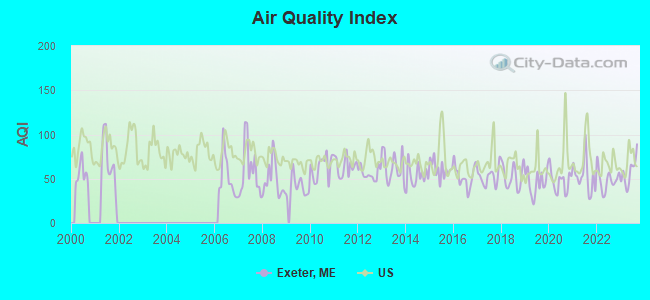
Air Quality Index (AQI) level in 2023 was 57.5. This is better than average.
| City: | 57.5 |
| U.S.: | 72.6 |
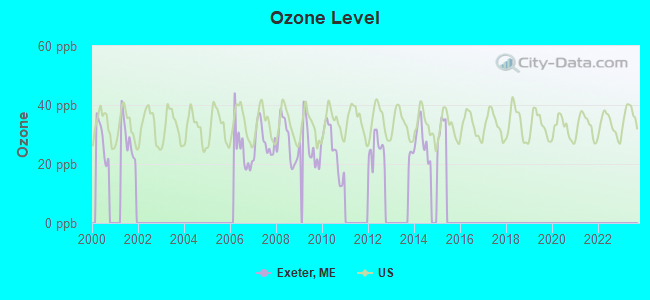
Ozone [ppb] level in 2015 was 16.3. This is significantly better than average. Closest monitor was 14.7 miles away from the city center.
| City: | 16.3 |
| U.S.: | 33.3 |
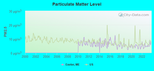
Particulate Matter (PM2.5) [µg/m3] level in 2023 was 5.62. This is significantly better than average. Closest monitor was 19.8 miles away from the city center.
| City: | 5.62 |
| U.S.: | 8.11 |
Earthquake activity:
Exeter-area historical earthquake activity is significantly above Maine state average. It is 81% smaller than the overall U.S. average.On 4/20/2002 at 10:50:47, a magnitude 5.3 (5.3 ML, Depth: 3.0 mi, Class: Moderate, Intensity: VI - VII) earthquake occurred 226.9 miles away from the city center
On 10/16/2012 at 23:12:25, a magnitude 4.7 (4.7 ML, Depth: 10.0 mi, Class: Light, Intensity: IV - V) earthquake occurred 121.1 miles away from Exeter center
On 4/20/2002 at 10:50:47, a magnitude 5.2 (5.2 MB, 4.2 MS, 5.2 MW, 5.0 MW) earthquake occurred 228.2 miles away from Exeter center
On 10/7/1983 at 10:18:46, a magnitude 5.3 (5.1 MB, 5.3 LG, 5.1 ML) earthquake occurred 266.9 miles away from the city center
On 1/19/1982 at 00:14:42, a magnitude 4.7 (4.5 MB, 4.7 MD, 4.5 LG) earthquake occurred 159.1 miles away from the city center
On 2/26/1999 at 03:38:43, a magnitude 3.8 (3.8 LG, Depth: 2.0 mi, Class: Light, Intensity: II - III) earthquake occurred 38.6 miles away from Exeter center
Magnitude types: regional Lg-wave magnitude (LG), body-wave magnitude (MB), duration magnitude (MD), local magnitude (ML), surface-wave magnitude (MS), moment magnitude (MW)
Natural disasters:
The number of natural disasters in Penobscot County (19) is greater than the US average (15).Major Disasters (Presidential) Declared: 11
Emergencies Declared: 7
Causes of natural disasters: Floods: 9, Storms: 8, Snows: 5, Heavy Rains: 2, Blizzard: 1, Hurricane: 1, Ice Storm: 1, Snowfall: 1, Wind: 1, Winter Storm: 1, Other: 2 (Note: some incidents may be assigned to more than one category).
Colleges/universities with over 2000 students nearest to Exeter:
- Husson University (about 19 miles; Bangor, ME; Full-time enrollment: 2,421)
- University of Maine (about 23 miles; Orono, ME; FT enrollment: 8,931)
- University of Maine at Farmington (about 55 miles; Farmington, ME; FT enrollment: 2,036)
- University of Maine at Augusta (about 55 miles; Augusta, ME; FT enrollment: 3,204)
- Saint Joseph's College of Maine (about 104 miles; Standish, ME; FT enrollment: 2,010)
- Southern Maine Community College (about 107 miles; South Portland, ME; FT enrollment: 4,666)
- University of Southern Maine (about 107 miles; Portland, ME; FT enrollment: 6,647)
Points of interest:
Notable location: Cider Hill (A). Display/hide its location on the map
Churches in Exeter include: Crossroads Church (A), Exeter Church (B). Display/hide their locations on the map
Cemeteries: Tibbets Cemetery (1), No Exeter Cemetery (2), Crowell Cemetery (3), Exeter Mills Cemetery (4), Chamberlain Cemetery (5), Bragg Cemetery (6). Display/hide their locations on the map
Reservoirs and swamps: French Stream (A), Greenbush Swamp (B). Display/hide their locations on the map
Streams, rivers, and creeks: Footman Brook (A), French Stream (B). Display/hide their locations on the map
Drinking water stations with addresses in Exeter that have no violations reported:
- EXETER WATER DEPARTMENT (Population served: 28, Primary Water Source Type: Groundwater)
| This town: | 2.6 people |
| Maine: | 2.3 people |
| This town: | 71.0% |
| Whole state: | 62.9% |
| This town: | 10.1% |
| Whole state: | 9.4% |
No gay or lesbian households reported
| This town: | 14.3% |
| Whole state: | 10.9% |
| This town: | 7.5% |
| Whole state: | 4.1% |
For population 15 years and over in Exeter:
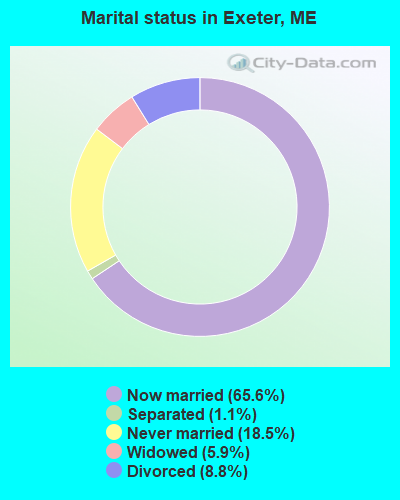
- Never married: 18.5%
- Now married: 65.6%
- Separated: 1.1%
- Widowed: 5.9%
- Divorced: 8.8%
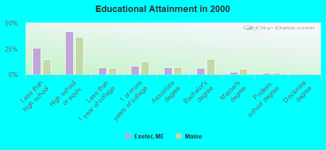
For population 25 years and over in Exeter:
- High school or higher: 74.4%
- Bachelor's degree or higher: 10.6%
- Graduate or professional degree: 4.1%
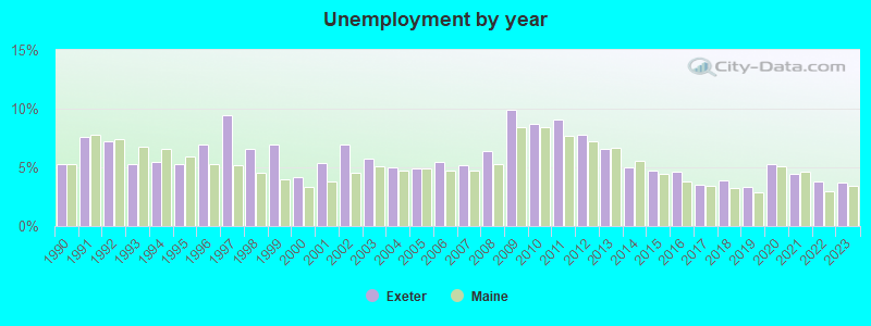
- Unemployed: 6.7%
- Mean travel time to work (commute): 33.4 minutes
| Here: | 12.6 |
| Maine average: | 11.2 |


Graphs represent county-level data. Detailed 2008 Election Results
Religion statistics for Exeter, ME (based on Penobscot County data)


| Religion | Adherents | Congregations |
|---|---|---|
| Catholic | 16,581 | 15 |
| Mainline Protestant | 9,715 | 59 |
| Evangelical Protestant | 7,523 | 80 |
| Other | 2,936 | 22 |
| Orthodox | 300 | 1 |
| None | 116,868 | - |
Food Environment Statistics:
| This county: | 2.29 / 10,000 pop. |
| Maine: | 2.80 / 10,000 pop. |
| Penobscot County: | 0.13 / 10,000 pop. |
| State: | 0.14 / 10,000 pop. |
| Penobscot County: | 2.56 / 10,000 pop. |
| Maine: | 2.20 / 10,000 pop. |
| This county: | 5.72 / 10,000 pop. |
| State: | 5.75 / 10,000 pop. |
| Penobscot County: | 7.41 / 10,000 pop. |
| State: | 11.02 / 10,000 pop. |
| This county: | 9.0% |
| State: | 8.2% |
| This county: | 28.0% |
| Maine: | 25.0% |
Strongest AM radio stations in Exeter:
- WZON (620 AM; 5 kW; BANGOR, ME; Owner: THE ZONE CORPORATION)
- WABI (910 AM; 5 kW; BANGOR, ME; Owner: CLEAR CHANNEL BROADCASTING LICENSES, INC.)
- WSKW (1160 AM; 10 kW; SKOWHEGAN, ME; Owner: MOUNTAIN WIRELESS, INCORPORATED)
- WTME (780 AM; 10 kW; RUMFORD, ME; Owner: MOUNTAIN VALLEY BROADCASTING, INC.)
- WRKO (680 AM; 50 kW; BOSTON, MA; Owner: ENTERCOM BOSTON LICENSE, LLC)
- WDEA (1370 AM; 5 kW; ELLSWORTH, ME; Owner: CUMULUS LICENSING CORP.)
- WNZS (1340 AM; 1 kW; VEAZIE, ME; Owner: WATERFRONT COMMUNICATIONS INC.)
- WEEI (850 AM; 50 kW; BOSTON, MA; Owner: ENTERCOM BOSTON LICENSE, LLC)
- WBZ (1030 AM; 50 kW; BOSTON, MA; Owner: INFINITY BROADCASTING OPERATIONS, INC.)
- WFAU (1280 AM; 5 kW; GARDINER, ME; Owner: CAPSTAR TX LIMITED PARTNERSHIP)
- WCRN (830 AM; 50 kW; WORCESTER, MA; Owner: CARTER BROADCASTING CORPORATION)
- WNNZ (640 AM; 50 kW; WESTFIELD, MA; Owner: CLEAR CHANNEL BROADCASTING LICENSES, INC.)
- WCHP (760 AM; 35 kW; CHAMPLAIN, NY; Owner: CHAMPLAIN RADIO, INC.)
Strongest FM radio stations in Exeter:
- WQCB (106.5 FM; BREWER, ME; Owner: CUMULUS LICENSING CORP.)
- WGUY (102.1 FM; DEXTER, ME; Owner: CONCORD MEDIA GROUP, INC.)
- WWBX (97.1 FM; BANGOR, ME; Owner: CLEAR CHANNEL BROADCASTING LICENSES, INC.)
- WVOM (103.9 FM; HOWLAND, ME; Owner: CLEAR CHANNEL BROADCASTING LICENSES, INC.)
- WBFB (104.7 FM; BELFAST, ME; Owner: CLEAR CHANNEL BROADCASTING LICENSES, INC.)
- WHCF (88.5 FM; BANGOR, ME; Owner: BANGOR BAPTIST CHURCH)
- WJCX (99.5 FM; PITTSFIELD, ME; Owner: CSN INTERNATIONAL)
- WBZN (107.3 FM; OLD TOWN, ME; Owner: CUMULUS LICENSING CORP.)
- WKIT-FM (100.3 FM; BREWER, ME; Owner: THE ZONE CORPORATION)
- WTOS-FM (105.1 FM; SKOWHEGAN, ME; Owner: CAPSTAR TX LIMITED PARTNERSHIP)
- WWMJ (95.7 FM; ELLSWORTH, ME; Owner: CUMULUS LICENSING CORP.)
- WMEH (90.9 FM; BANGOR, ME; Owner: MAINE PUBLIC BROADCASTING CORPORATION)
- WEZQ (92.9 FM; BANGOR, ME; Owner: CUMULUS LICENSING CORP.)
- WFZX (101.7 FM; SEARSPORT, ME; Owner: CLEAR CHANNEL BROADCASTING LICENSES, INC.)
- WDME-FM (103.1 FM; DOVER-FOXCROFT, ME; Owner: THE ZONE CORPORATION)
- WHQO (107.9 FM; SKOWHEGAN, ME; Owner: MOUNTAIN WIRELESS, INC.)
- WCTB (93.5 FM; FAIRFIELD, ME; Owner: MOUNTAIN WIRELESS, INC.)
TV broadcast stations around Exeter:
- WABI-TV (Channel 5; BANGOR, ME; Owner: COMMUNITY BROADCASTING SERVICE)
- W36CK (Channel 36; BANGOR, ME; Owner: TRINITY BROADCASTING NETWORK)
Exeter fatal accident list:
Nov 20, 1988 12:00 AM, 14231432, Vehicles: 1, Persons: 2, Fatalities: 1
Dec 5, 1987 05:30 PM, 14315018, Vehicles: 1, Persons: 1, Fatalities: 1, Drunk persons involved: 1
- National Bridge Inventory (NBI) Statistics
- 4Number of bridges
- 13ft / 4.0mTotal length
- 502,813Total average daily traffic
- 25,139Total average daily truck traffic
- 3,015Total future (year 2036) average daily traffic
FCC Registered Broadcast Land Mobile Towers:
2- Lat: 44.942833 Lon: -69.076694, Call Sign: WQNZ978,
Assigned Frequencies: 159.825 MHz, Grant Date: 07/21/2011, Expiration Date: 07/21/2021, Cancellation Date: 10/09/2021, Certifier: Scott C Eastman, Registrant: Atlantic Communications, Inc., Bangor, ME 04402, Phone: (207) 848-7590, Fax: (207) 433-7760, Email:
- 180 Tibbetts Road (Lat: 44.941694 Lon: -69.120500), Type: Gtower, Structure height: 60.7 m, Call Sign: WQZP381,
Assigned Frequencies: 461.100 MHz, Grant Date: 06/26/2017, Expiration Date: 06/26/2027, Certifier: Travis Fogler, Registrant: Stonyvale Farm LLC, 226 Fogler Rd., Exeter, ME 04435, Phone: (207) 379-2963, Email:
FCC Registered Amateur Radio Licenses:
7- Call Sign: AA1PN, Licensee ID: L00482279, Grant Date: 04/05/2022, Expiration Date: 06/09/2032, Certifier: Clarence I Rider Jr, Registrant: Clarence I Rider Jr, 214 Tibbetts Rd, Exeter, ME 04435
- Call Sign: N1LFJ, Licensee ID: L00415671, Grant Date: 12/05/2011, Expiration Date: 01/28/2022, Cancellation Date: 01/30/2024, Certifier: Eugene H Stocker, Registrant: Eugene H Stocker, Exeter, ME 04435
- Call Sign: N1WTO, Licensee ID: L01173572, Grant Date: 05/03/2017, Expiration Date: 05/03/2027, Certifier: Arlene M Rider, Registrant: Arlene M Rider, 214 Tibbettes Rd, Exeter, ME 04435
- Call Sign: N1YJP, Licensee ID: L01252976, Grant Date: 05/03/2017, Expiration Date: 05/03/2027, Certifier: Clarence I Rider Iii, Registrant: Clarence I Rider Iii, 214 Tibbetts Rd, Exeter, ME 04435
- Call Sign: KB1QQH, Licensee ID: L01408078, Grant Date: 06/13/2008, Expiration Date: 06/13/2018, Cancellation Date: 08/05/2011, Certifier: Warren R Akerblom, Registrant: Warren R Akerblom, 231 Between The Mill Rd, Exeter, ME 04435
- Call Sign: KB1VZD, Previous Call Sign: KB1QQH, Licensee ID: L01408078, Grant Date: 06/13/2008, Expiration Date: 06/13/2018, Cancellation Date: 03/17/2012, Certifier: Warren R Akerblom, Registrant: Warren R Akerblom, 231 Between The Mill Rd, Exeter, ME 04435
- Call Sign: N1WRA, Previous Call Sign: KB1VZD, Licensee ID: L01408078, Grant Date: 01/27/2022, Expiration Date: 03/17/2032, Certifier: Warren R Akerblom, Registrant: Warren R Akerblom, 231 Between The Mills Rd, Exeter, ME 04435
FAA Registered Aircraft:
2- Aircraft: CUBCRAFTERS INC CC11-160 (Category: Land, Seats: 2, Weight: Up to 12,499 Pounds), Engine: TITAN OX-340CC (180 HP) (4 Cycle)
N-Number: 95JC, N95JC, N-95JC, Serial Number: CC11-00424, Year manufactured: 2017, Airworthiness Date: 10/23/2017, Certificate Issue Date: 11/19/2019
Registrant (LLC): Crane Plane LLC, 2084 Exeter Rd, Exeter, ME 04435 - Aircraft: CUBCRAFTERS INC CC11-160 (Category: Land, Seats: 2, Weight: Up to 12,499 Pounds), Engine: CUBCRAFTER CC340 (180 HP) (4 Cycle)
N-Number: 745JB, N745JB, N-745JB, Serial Number: CC11-00249, Year manufactured: 2013, Airworthiness Date: 01/15/2013, Certificate Issue Date: 05/09/2019
Registrant (LLC): Crane Plane LLC, 2084 Exeter Rd, Exeter, ME 04435
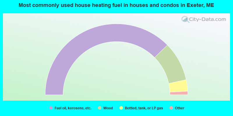
- 75.3%Fuel oil, kerosene, etc.
- 17.9%Wood
- 5.2%Bottled, tank, or LP gas
- 0.8%Electricity
- 0.8%No fuel used
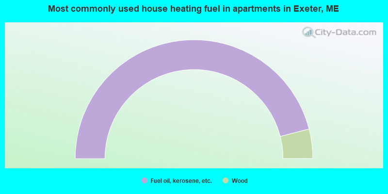
- 92.0%Fuel oil, kerosene, etc.
- 8.0%Wood
Exeter compared to Maine state average:
- Median house value below state average.
- Unemployed percentage below state average.
- Black race population percentage significantly below state average.
- Hispanic race population percentage below state average.
- Foreign-born population percentage significantly below state average.
- Renting percentage significantly below state average.
- Length of stay since moving in significantly above state average.
- Number of rooms per house significantly below state average.
- House age significantly below state average.
- Percentage of population with a bachelor's degree or higher significantly below state average.