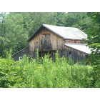
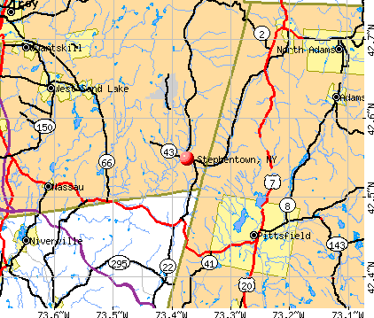
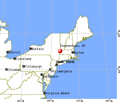
Stephentown, New York
Submit your own pictures of this town and show them to the world
- OSM Map
- General Map
- Google Map
- MSN Map
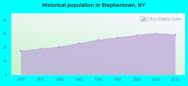
Population change since 2000: +1.0%
 |
| Males: 1,455 | |
| Females: 1,448 |
| Median resident age: | 44.3 years |
| New York median age: | 40.7 years |
Zip codes: 12168.
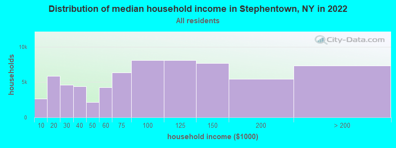
| Stephentown: | $84,273 |
| NY: | $79,557 |
Estimated per capita income in 2022: $41,680 (it was $18,822 in 2000)
Stephentown town income, earnings, and wages data
Estimated median house or condo value in 2022: $232,251 (it was $93,200 in 2000)
| Stephentown: | $232,251 |
| NY: | $400,400 |
Mean prices in 2022: all housing units: $261,820; detached houses: $276,434; townhouses or other attached units: $265,307; in 2-unit structures: $183,863; in 3-to-4-unit structures: $134,506; in 5-or-more-unit structures: $370,413; mobile homes: $66,260
Detailed information about poverty and poor residents in Stephentown, NY


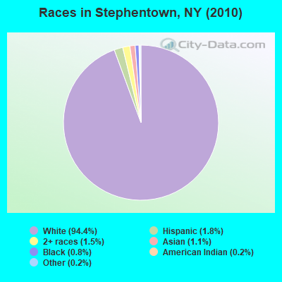
- 2,73994.4%White alone
- 511.8%Hispanic
- 431.5%Two or more races
- 331.1%Asian alone
- 240.8%Black alone
- 60.2%American Indian alone
- 60.2%Other race alone
- 10.03%Native Hawaiian and Other
Pacific Islander alone
Races in Stephentown detailed stats: ancestries, foreign born residents, place of birth
According to our research of New York and other state lists, there were 6 registered sex offenders living in Stephentown, New York as of May 09, 2024.
The ratio of all residents to sex offenders in Stephentown is 484 to 1.
 Recent articles from our blog. Our writers, many of them Ph.D. graduates or candidates, create easy-to-read articles on a wide variety of topics.

 | Growing Up in the 518 - Favorite Winter Memories? (11 replies) |
| Eastern Upstate NY or Western Massachusetts? (20 replies) |
| coming out from the west coast.... curious about Stephentown (4 replies) |
| Relocating to Albany Area, Need Info (5 replies) |
Latest news from Stephentown, NY collected exclusively by city-data.com from local newspapers, TV, and radio stations
Ancestries: Irish (18.5%), German (18.1%), English (15.2%), Italian (9.7%), United States (9.0%), French (7.7%).
Current Local Time: EST time zone
Elevation: 878 feet
Land area: 58.0 square miles.
Population density: 50 people per square mile (very low).
35 residents are foreign born
| This town: | 1.2% |
| New York: | 20.4% |
| Stephentown town: | 2.2% ($2,018) |
| New York: | 1.9% ($2,847) |
Nearest city with pop. 50,000+: Albany, NY  (20.2 miles , pop. 95,658).
Nearest city with pop. 200,000+: Bronx, NY (119.8 miles , pop. 1,332,650).
Nearest cities:
), ), ), ), )Latitude: 42.54 N, Longitude: 73.42 W
Area code: 518

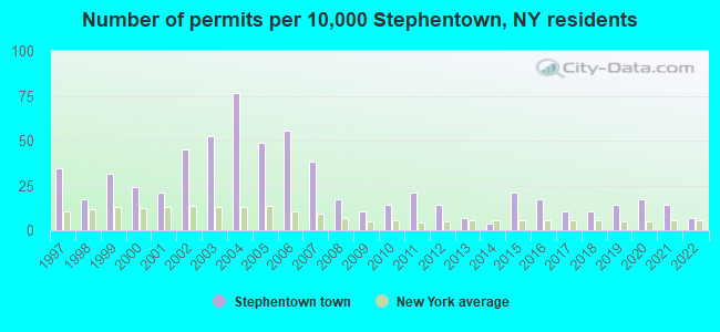
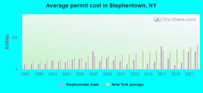
Single-family new house construction building permits:
- 2022: 2 buildings, average cost: $282,500
- 2021: 4 buildings, average cost: $285,000
- 2020: 5 buildings, average cost: $106,000
- 2019: 4 buildings, average cost: $73,500
- 2018: 3 buildings, average cost: $178,300
- 2017: 3 buildings, average cost: $359,300
- 2016: 5 buildings, average cost: $116,000
- 2015: 6 buildings, average cost: $96,700
- 2014: 1 building, cost: $15,000
- 2013: 2 buildings, average cost: $158,400
- 2012: 4 buildings, average cost: $81,500
- 2011: 6 buildings, average cost: $136,200
- 2010: 4 buildings, average cost: $144,500
- 2009: 3 buildings, average cost: $183,300
- 2008: 5 buildings, average cost: $125,000
- 2007: 11 buildings, average cost: $289,200
- 2006: 16 buildings, average cost: $115,100
- 2005: 14 buildings, average cost: $171,500
- 2004: 22 buildings, average cost: $162,600
- 2003: 15 buildings, average cost: $116,700
- 2002: 13 buildings, average cost: $126,900
- 2001: 6 buildings, average cost: $144,300
- 2000: 7 buildings, average cost: $85,700
- 1999: 9 buildings, average cost: $83,700
- 1998: 5 buildings, average cost: $86,400
- 1997: 10 buildings, average cost: $85,000
| Here: | 3.7% |
| New York: | 4.4% |
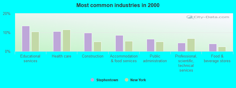
- Educational services (13.5%)
- Health care (10.5%)
- Construction (9.8%)
- Accommodation & food services (8.5%)
- Public administration (6.6%)
- Professional, scientific, technical services (4.4%)
- Food & beverage stores (4.0%)

- Construction (17.6%)
- Educational services (8.8%)
- Accommodation & food services (6.7%)
- Public administration (6.1%)
- Health care (5.1%)
- Professional, scientific, technical services (4.5%)
- Administrative & support & waste management services (4.4%)
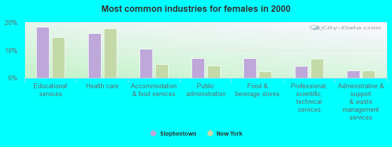
- Educational services (18.3%)
- Health care (16.0%)
- Accommodation & food services (10.4%)
- Public administration (7.0%)
- Food & beverage stores (7.0%)
- Professional, scientific, technical services (4.3%)
- Administrative & support & waste management services (2.7%)
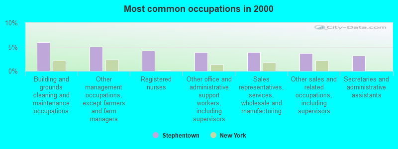
- Building and grounds cleaning and maintenance occupations (6.0%)
- Other management occupations, except farmers and farm managers (5.1%)
- Registered nurses (4.2%)
- Other office and administrative support workers, including supervisors (4.0%)
- Sales representatives, services, wholesale and manufacturing (3.9%)
- Other sales and related occupations, including supervisors (3.7%)
- Secretaries and administrative assistants (3.2%)
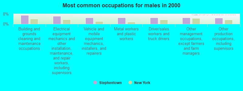
- Building and grounds cleaning and maintenance occupations (7.1%)
- Electrical equipment mechanics and other installation, maintenance, and repair workers, including supervisors (6.4%)
- Vehicle and mobile equipment mechanics, installers, and repairers (5.2%)
- Metal workers and plastic workers (5.2%)
- Driver/sales workers and truck drivers (5.1%)
- Other management occupations, except farmers and farm managers (5.1%)
- Other production occupations, including supervisors (4.9%)
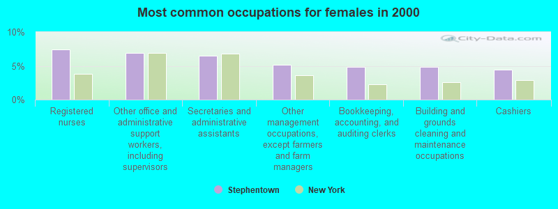
- Registered nurses (7.4%)
- Other office and administrative support workers, including supervisors (6.9%)
- Secretaries and administrative assistants (6.5%)
- Other management occupations, except farmers and farm managers (5.1%)
- Bookkeeping, accounting, and auditing clerks (4.9%)
- Building and grounds cleaning and maintenance occupations (4.9%)
- Cashiers (4.4%)
Average climate in Stephentown, New York
Based on data reported by over 4,000 weather stations


(lower is better)
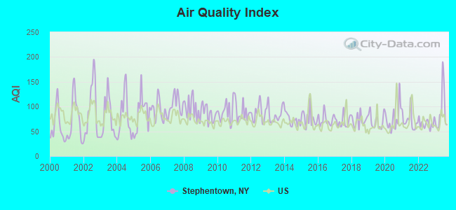
Air Quality Index (AQI) level in 2023 was 89.6. This is worse than average.
| City: | 89.6 |
| U.S.: | 72.6 |
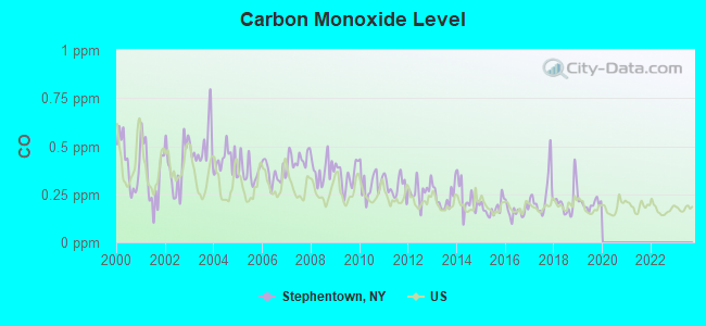
Carbon Monoxide (CO) [ppm] level in 2019 was 0.199. This is better than average. Closest monitor was 11.3 miles away from the city center.
| City: | 0.199 |
| U.S.: | 0.251 |
Sulfur Dioxide (SO2) [ppb] level in 2021 was 0.213. This is significantly better than average. Closest monitor was 10.9 miles away from the city center.
| City: | 0.213 |
| U.S.: | 1.515 |
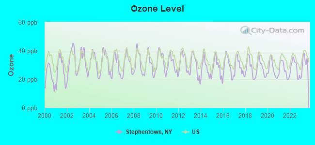
Ozone [ppb] level in 2023 was 31.2. This is about average. Closest monitor was 11.0 miles away from the city center.
| City: | 31.2 |
| U.S.: | 33.3 |
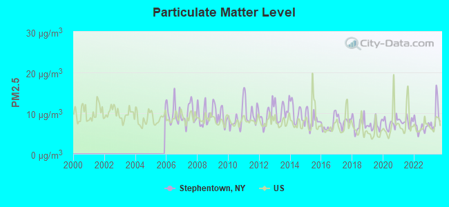
Particulate Matter (PM2.5) [µg/m3] level in 2023 was 9.06. This is about average. Closest monitor was 10.4 miles away from the city center.
| City: | 9.06 |
| U.S.: | 8.11 |
Tornado activity:
Stephentown-area historical tornado activity is above New York state average. It is 27% smaller than the overall U.S. average.
On 8/28/1973, a category F4 (max. wind speeds 207-260 mph) tornado 8.6 miles away from the Stephentown town center killed 4 people and injured 36 people and caused between $5,000,000 and $50,000,000 in damages.
On 5/29/1995, a category F4 tornado 23.8 miles away from the town center killed 3 people and injured 24 people and caused between $5,000,000 and $50,000,000 in damages.
Earthquake activity:
Stephentown-area historical earthquake activity is significantly above New York state average. It is 68% smaller than the overall U.S. average.On 10/7/1983 at 10:18:46, a magnitude 5.3 (5.1 MB, 5.3 LG, 5.1 ML, Class: Moderate, Intensity: VI - VII) earthquake occurred 108.0 miles away from the city center
On 4/20/2002 at 10:50:47, a magnitude 5.3 (5.3 ML, Depth: 3.0 mi) earthquake occurred 136.8 miles away from Stephentown center
On 4/20/2002 at 10:50:47, a magnitude 5.2 (5.2 MB, 4.2 MS, 5.2 MW, 5.0 MW) earthquake occurred 135.2 miles away from Stephentown center
On 1/19/1982 at 00:14:42, a magnitude 4.7 (4.5 MB, 4.7 MD, 4.5 LG, Class: Light, Intensity: IV - V) earthquake occurred 113.1 miles away from the city center
On 10/16/2012 at 23:12:25, a magnitude 4.7 (4.7 ML, Depth: 10.0 mi) earthquake occurred 157.3 miles away from the city center
On 6/17/1991 at 08:53:16, a magnitude 4.1 (4.0 MB, 4.0 LG, Depth: 3.1 mi) earthquake occurred 64.5 miles away from the city center
Magnitude types: regional Lg-wave magnitude (LG), body-wave magnitude (MB), duration magnitude (MD), local magnitude (ML), surface-wave magnitude (MS), moment magnitude (MW)
Natural disasters:
The number of natural disasters in Rensselaer County (24) is greater than the US average (15).Major Disasters (Presidential) Declared: 14
Emergencies Declared: 9
Causes of natural disasters: Storms: 7, Floods: 5, Hurricanes: 5, Winter Storms: 4, Blizzards: 2, Snowstorms: 2, Tornadoes: 2, Chemical Waste: 1, Power Outage: 1, Tropical Storm: 1, Other: 2 (Note: some incidents may be assigned to more than one category).

Hospitals and medical centers near Stephentown:
- BERKSHIRE VISITING NURSE ASSOCIATION (Home Health Center, about 10 miles away; PITTSFIELD, MA)
- HILLCREST HOSPITAL (Hospital, about 10 miles away; PITTSFIELD, MA)
- HILLCREST COMMONS NURSING AND REHABILITATION CENTER (Nursing Home, about 10 miles away; PITTSFIELD, MA)
- SPRINGSIDE REHABILITATION AND SKILLED CARE CENTER (Nursing Home, about 10 miles away; PITTSFIELD, MA)
- CENTER FOR OPTIMUM CARE-BERKSHIRE (Nursing Home, about 11 miles away; PITTSFIELD, MA)
- MT GREYLOCK EXTENDED CARE FACILITY (Nursing Home, about 11 miles away; PITTSFIELD, MA)
- BERKSHIRE MEDICAL CENTER INC Acute Care Hospitals (about 11 miles away; PITTSFIELD, MA)
Amtrak stations near Stephentown:
- 11 miles: PITTSFIELD (DEPOT ST. BTW NORTH & CENTER STS.) . Services: enclosed waiting area, public payphones, free short-term parking, free long-term parking, taxi stand, intercity bus service, public transit connection.
- 18 miles: ALBANY-RENSSELAER (RENSSELAER, 555 EAST ST.) . Services: ticket office, partially wheelchair accessible, enclosed waiting area, public restrooms, public payphones, snack bar, ATM, free short-term parking, free long-term parking, call for car rental service, taxi stand, public transit connection.
Colleges/universities with over 2000 students nearest to Stephentown:
- Williams College (about 16 miles; Williamstown, MA; Full-time enrollment: 2,141)
- Hudson Valley Community College (about 18 miles; Troy, NY; FT enrollment: 9,346)
- Rensselaer Polytechnic Institute (about 19 miles; Troy, NY; FT enrollment: 6,940)
- The Sage Colleges (about 19 miles; Troy, NY; FT enrollment: 2,499)
- The College of Saint Rose (about 21 miles; Albany, NY; FT enrollment: 4,085)
- Siena College (about 21 miles; Loudonville, NY; FT enrollment: 3,153)
- SUNY at Albany (about 24 miles; Albany, NY; FT enrollment: 15,490)
Points of interest:
Notable locations in Stephentown: Seven Hill Firetower (A), Sugar Bush Farm (B), Stone Wall Hill Farm (C), Zema's Nursery (D), Stephentown Memorial Library (E). Display/hide their locations on the map
Churches in Stephentown include: Evangelical Community Church (A), Stephentown Federated Church (B). Display/hide their locations on the map
Cemeteries: Sacred Heart Cemetery (1), Saint Josephs Cemetery (2), Presbyterian Hill Cemetery (3), Hillside Cemetery (4), Garfield Cemetery (5). Display/hide their locations on the map
Lakes and swamps: Stone Bridge Pond (A), Stump Pond (B), Taplin Pond (C), Black Pond (D), Douglas Pond (E), Griswold Pond (F), Sabarney Gile Swamp (G). Display/hide their locations on the map
Streams, rivers, and creeks: Taplin Bourn (A), East Brook (B), Roaring Brook (C), Black River (D), West Brook (E), Huff Brook (F). Display/hide their locations on the map
Birthplace of: Zadock Pratt - Politician, Roy Face - Baseball player, David Holloway (American football) - Football player.
Drinking water stations with addresses in Stephentown and their reported violations in the past:
BERKSHIRE FARM CENTER (Address: 129 PRESBYTERIAN HILL , Population served: 420, Groundwater):Past monitoring violations:PIZZA PLUS (Population served: 100, Groundwater):
- One routine major monitoring violation
Past monitoring violations:GARDNERS COFFEE SHOP (Population served: 25, Groundwater):
- 7 routine major monitoring violations
Past monitoring violations:
- 6 routine major monitoring violations
| This town: | 2.4 people |
| New York: | 2.6 people |
| This town: | 66.7% |
| Whole state: | 63.5% |
| This town: | 10.3% |
| Whole state: | 6.8% |
Likely homosexual households (counted as self-reported same-sex unmarried-partner households)
- Lesbian couples: 0.9% of all households
- Gay men: 0.8% of all households
| This town: | 6.6% |
| Whole state: | 14.6% |
| This town: | 2.2% |
| Whole state: | 7.4% |
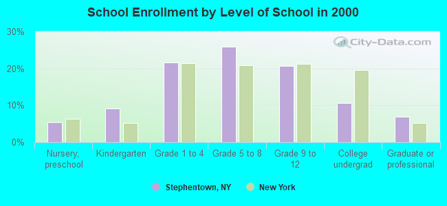
For population 15 years and over in Stephentown:
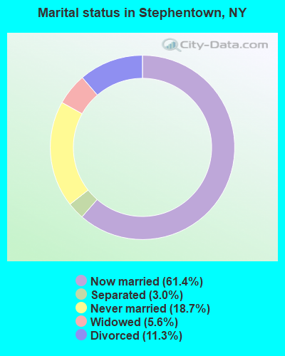
- Never married: 18.7%
- Now married: 61.4%
- Separated: 3.0%
- Widowed: 5.6%
- Divorced: 11.3%
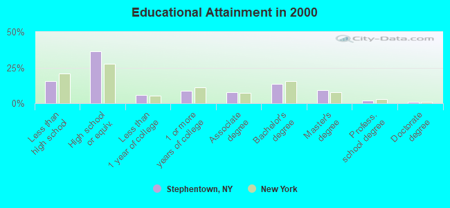
For population 25 years and over in Stephentown:
- High school or higher: 84.3%
- Bachelor's degree or higher: 25.6%
- Graduate or professional degree: 11.9%
- Unemployed: 4.4%
- Mean travel time to work (commute): 31.7 minutes
| Here: | 11.0 |
| New York average: | 14.2 |
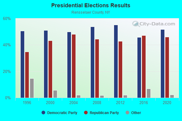
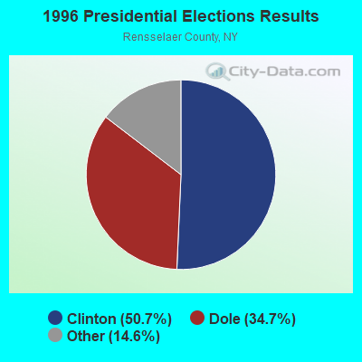
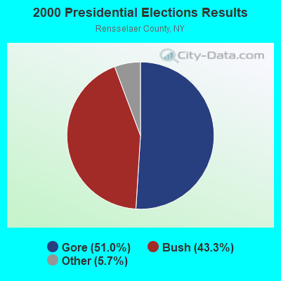
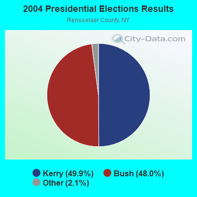
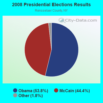
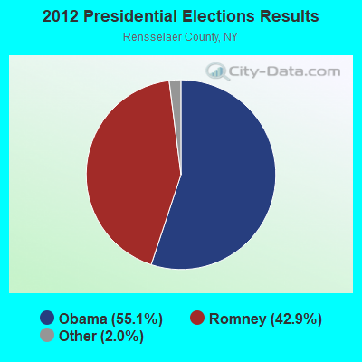
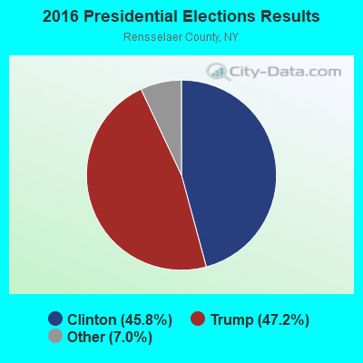
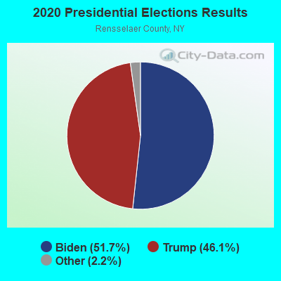
Graphs represent county-level data. Detailed 2008 Election Results
Religion statistics for Stephentown, NY (based on Rensselaer County data)
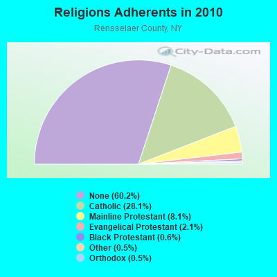
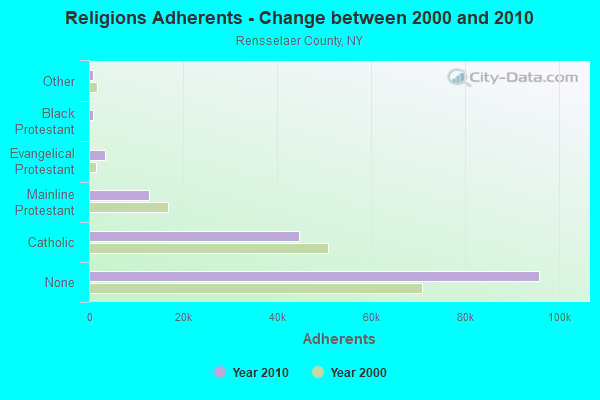
| Religion | Adherents | Congregations |
|---|---|---|
| Catholic | 44,756 | 21 |
| Mainline Protestant | 12,867 | 70 |
| Evangelical Protestant | 3,424 | 37 |
| Black Protestant | 882 | 3 |
| Other | 847 | 12 |
| Orthodox | 740 | 3 |
| None | 95,913 | - |
Food Environment Statistics:
| This county: | 2.07 / 10,000 pop. |
| New York: | 4.13 / 10,000 pop. |
| This county: | 0.84 / 10,000 pop. |
| New York: | 0.92 / 10,000 pop. |
| Here: | 3.55 / 10,000 pop. |
| New York: | 1.68 / 10,000 pop. |
| Here: | 6.07 / 10,000 pop. |
| New York: | 8.82 / 10,000 pop. |
| Here: | 7.4% |
| State: | 8.2% |
| Here: | 26.7% |
| State: | 23.8% |
| This county: | 15.4% |
| New York: | 15.6% |
Businesses in Stephentown, NY
- Dunkin Donuts: 1
Strongest AM radio stations in Stephentown:
- WGY (810 AM; 50 kW; SCHENECTADY, NY; Owner: CLEAR CHANNEL BROADCASTING LICENSES, INC.)
- WUHN (1110 AM; daytime; 5 kW; PITTSFIELD, MA; Owner: WEINER BROADCASTING, INC.)
- WPTR (1540 AM; 50 kW; ALBANY, NY; Owner: KIMTRON, INC.)
- WNNZ (640 AM; 50 kW; WESTFIELD, MA; Owner: CLEAR CHANNEL BROADCASTING LICENSES, INC.)
- WROW (590 AM; 5 kW; ALBANY, NY; Owner: 6 JOHNSON ROAD LICENSES, INC.)
- WTMM (1300 AM; 5 kW; RENSSELAER, NY; Owner: REGENT LICENSEE OF MANSFIELD, INC.)
- WTIC (1080 AM; 50 kW; HARTFORD, CT; Owner: INFINITY RADIO OPERATIONS INC.)
- WCRN (830 AM; 50 kW; WORCESTER, MA; Owner: CARTER BROADCASTING CORPORATION)
- WDDY (1460 AM; 5 kW; ALBANY, NY)
- WBEC (1420 AM; 1 kW; PITTSFIELD, MA; Owner: GREAT NORTHERN RADIO, LLC)
- WOFX (980 AM; 5 kW; TROY, NY)
- WVNE (760 AM; daytime; 25 kW; LEICESTER, MA; Owner: BLOUNT MASSCOM, INC.)
- WSBS (860 AM; 3 kW; GREAT BARRINGTON, MA; Owner: BERKSHIRE BROADCASTING CO., INC.)
Strongest FM radio stations in Stephentown:
- WAMC-FM (90.3 FM; ALBANY, NY; Owner: WAMC)
- WZEC (97.5 FM; HOOSICK FALLS, NY; Owner: GREAT NORTHERN RADIO, LLC)
- WHVP (91.1 FM; HUDSON, NY; Owner: SOUND OF LIFE, INC.)
- WBEC-FM (105.5 FM; PITTSFIELD, MA; Owner: GREAT NORTHERN RADIO, LLC)
- WUPE (95.9 FM; PITTSFIELD, MA; Owner: WEINER BROADCASTING, INC.)
- WEQX (102.7 FM; MANCHESTER, VT; Owner: NORTHSHIRE COMMUNICATIONS, INC.)
- WJAN (95.1 FM; SUNDERLAND, VT; Owner: 6 JOHNSON ROAD LICENSES, INC.)
- WAJZ (96.3 FM; VOORHEESVILLE, NY; Owner: 6 JOHNSON ROAD LICENSES, INC.)
- WAMQ (105.1 FM; GREAT BARRINGTON, MA; Owner: WAMC)
- WVAY (100.7 FM; WILMINGTON, VT; Owner: GREAT NORTHERN RADIO, L.L.C.)
- WZMR (104.9 FM; ALTAMONT, NY; Owner: 6 JOHNSON ROAD LICENSES, INC.)
- WYJB (95.5 FM; ALBANY, NY; Owner: 6 JOHNSON ROAD LICENSES, INC.)
- WGNA-FM (107.7 FM; ALBANY, NY; Owner: REGENT LICENSEE OF MANSFIELD, INC.)
- WRVE (99.5 FM; SCHENECTADY, NY; Owner: CLEAR CHANNEL BROADCASTING LICENSES, INC.)
- WMHT-FM (89.1 FM; SCHENECTADY, NY; Owner: WMHT EDUCATIONAL TELECOMMUNICATIONS)
- WPYX (106.5 FM; ALBANY, NY; Owner: CAPSTAR TX LIMITED PARTNERSHIP)
- WVCR-FM (88.3 FM; LOUDONVILLE, NY; Owner: SIENA COLLEGE)
- WFLY (92.3 FM; TROY, NY; Owner: 6 JOHNSON ROAD LICENSES, INC.)
- WMNB (100.1 FM; NORTH ADAMS, MA; Owner: BERKSHIRE BROADCASTING CO., INC.)
- WAMK (90.9 FM; KINGSTON, NY; Owner: W A M C)
TV broadcast stations around Stephentown:
- WCDC-TV (Channel 19; ADAMS, MA; Owner: YOUNG BROADCASTING OF ALBANY, INC.)
- WNGN-LP (Channel 26; TROY, NY; Owner: BRIAN A. LARSON)
- W38DL (Channel 38; ADAMS, ETC., MA; Owner: WNYT-TV, LLC)
- WNYT (Channel 13; ALBANY, NY; Owner: WNYT-TV, LLC)
- WRGB (Channel 6; SCHENECTADY, NY; Owner: FREEDOM BROADCASTING OF NEW YORK, INC)
- National Bridge Inventory (NBI) Statistics
- 18Number of bridges
- 95ft / 28.8mTotal length
- $15,140,000Total costs
- 13,233Total average daily traffic
- 1,155Total average daily truck traffic
- 14,979Total future (year 2036) average daily traffic
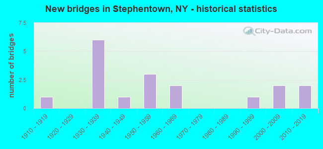
- New bridges - historical statistics
- 11910-1919
- 61930-1939
- 11940-1949
- 31950-1959
- 21960-1969
- 11990-1999
- 22000-2009
- 22010-2019
FCC Registered Cell Phone Towers:
3 (See the full list of FCC Registered Cell Phone Towers in Stephentown)FCC Registered Antenna Towers:
11 (See the full list of FCC Registered Antenna Towers)FCC Registered Broadcast Land Mobile Towers:
2- TINLEY, Tinley Rd. Off Rte 43 (Lat: 42.557778 Lon: -73.444333), Type: Tower, Structure height: 57.9 m, Overall height: 59.4 m, Call Sign: WPJS218,
Assigned Frequencies: 856.462 MHz, 856.962 MHz, 857.462 MHz, 857.962 MHz, 858.462 MHz, Grant Date: 07/30/2021, Expiration Date: 10/01/2031, Certifier: David Cook, Registrant: Algonquin Communications, 434 West Sand Lake Road, Wynantskill, NY 12198, Phone: (518) 857-6792, Email:
- Tinley Road (End) (Lat: 42.557306 Lon: -73.444333), Type: Ltower, Structure height: 38.3 m, Overall height: 45 m, Call Sign: WQPN764,
Assigned Frequencies: 155.857 MHz, Grant Date: 05/07/2022, Expiration Date: 07/10/2032, Certifier: Jim Karam, Registrant: Algonquin Communications, 434 West Sand Lake Road, Wynantskill, NY 12198, Phone: (518) 857-6792, Email:
FCC Registered Microwave Towers:
2- STEPHENTOWN, Fire Tower Rd (Lat: 42.605611 Lon: -73.460111), Overall height: 91.4 m, Call Sign: WMR757,
Assigned Frequencies: 10551.2 MHz, Grant Date: 01/25/2011, Expiration Date: 02/01/2021, Cancellation Date: 03/18/2014, Registrant: Verizon Wireless, 1120 Sanctuary Pkwy, #150 Gasa5reg, Alpharetta, GA 30009-7630, Phone: (770) 797-1070, Fax: (770) 797-1036, Email:
- TINLEY, Tinley Road (Lat: 42.557250 Lon: -73.444333), Type: Ltower, Structure height: 57.9 m, Overall height: 59.4 m, Call Sign: WQIP406,
Assigned Frequencies: 6795.00 MHz, 6585.00 MHz, 5945.20 MHz, 6152.75 MHz, Grant Date: 04/03/2008, Expiration Date: 04/03/2018, Cancellation Date: 06/09/2018, Certifier: Kelly Paslow, Registrant: Rensselaer County Bureau Of Public Safety, 4000 Main Street, Troy, NY 12180, Phone: (518) 266-7673, Fax: (518) 270-4164, Email:
FCC Registered Amateur Radio Licenses:
30 (See the full list of FCC Registered Amateur Radio Licenses in Stephentown)FAA Registered Aircraft:
3- Aircraft: BELLANCA 17-30A (Category: Land, Seats: 4, Weight: Up to 12,499 Pounds, Speed: 142 mph), Engine: CONT MOTOR IO 520 SERIES (285 HP) (Reciprocating)
N-Number: 114PG, N114PG, N-114PG, Serial Number: 30370, Year manufactured: 1971, Airworthiness Date: 06/28/1971, Certificate Issue Date: 06/15/2007
Registrant (Corporation): Regional Medical, 424 Madden Rd, Stephentown, NY 12168 - Aircraft: STINSON 108-3 (Category: Land, Seats: 4, Weight: Up to 12,499 Pounds, Speed: 94 mph), Engine: FRANKLIN 6A4165 SERIES (165 HP) (Reciprocating)
N-Number: 6787M, N6787M, N-6787M, Serial Number: 108-4787, Year manufactured: 1949, Airworthiness Date: 08/05/2015, Certificate Issue Date: 04/18/2014
Registrant (Individual): Dana F Tarr, 94 Calvin Cole Rd, Stephentown, NY 12169 - Aircraft: PIPER PA-25-260 (Category: Land, Weight: Up to 12,499 Pounds, Speed: 93 mph), Engine: LYCOMING 0-540 SERIES (250 HP) (Reciprocating)
N-Number: 6802L, N6802L, N-6802L, Serial Number: 25-7405659, Year manufactured: 1974, Airworthiness Date: 06/20/1974, Certificate Issue Date: 05/17/2012
Registrant (Individual): Louis C Christie, Po Box 444, Stephentown, NY 12168
Deregistered: Cancel Date: 02/16/2018
| Most common first names in Stephentown, NY among deceased individuals | ||
| Name | Count | Lived (average) |
|---|---|---|
| John | 21 | 73.2 years |
| William | 15 | 76.1 years |
| Mary | 13 | 81.7 years |
| Helen | 12 | 80.7 years |
| George | 11 | 74.2 years |
| Elizabeth | 10 | 84.7 years |
| Charles | 9 | 75.5 years |
| Walter | 8 | 79.0 years |
| Robert | 8 | 61.0 years |
| Donald | 7 | 72.5 years |
| Most common last names in Stephentown, NY among deceased individuals | ||
| Last name | Count | Lived (average) |
|---|---|---|
| Atwater | 10 | 74.8 years |
| Brown | 8 | 78.5 years |
| Rathbun | 6 | 77.1 years |
| Smith | 5 | 79.2 years |
| Gardner | 5 | 72.8 years |
| Johnson | 5 | 76.8 years |
| Griffin | 5 | 70.8 years |
| Adams | 4 | 72.8 years |
| Williams | 4 | 81.0 years |
| Kenyon | 4 | 89.4 years |
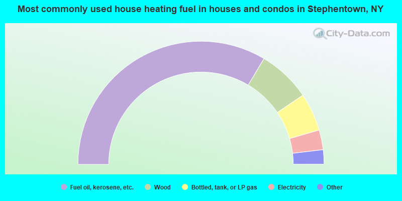
- 67.2%Fuel oil, kerosene, etc.
- 13.9%Wood
- 10.0%Bottled, tank, or LP gas
- 5.2%Electricity
- 1.9%Utility gas
- 1.4%Other fuel
- 0.4%Coal or coke
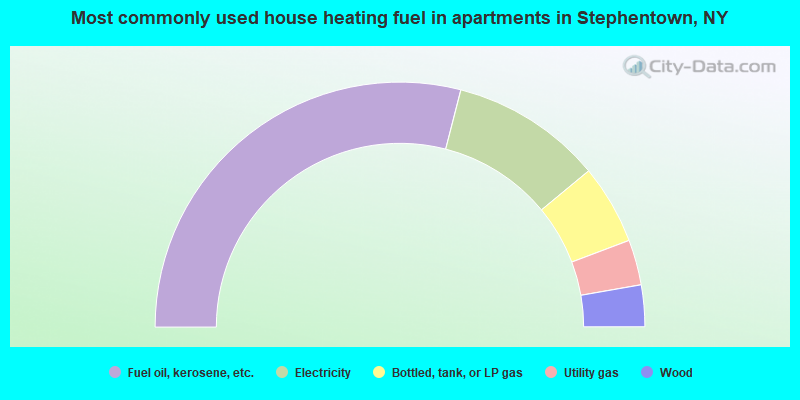
- 58.0%Fuel oil, kerosene, etc.
- 20.0%Electricity
- 10.5%Bottled, tank, or LP gas
- 6.0%Utility gas
- 5.5%Wood
Stephentown compared to New York state average:
- Median house value below state average.
- Unemployed percentage significantly below state average.
- Black race population percentage significantly below state average.
- Hispanic race population percentage significantly below state average.
- Foreign-born population percentage significantly below state average.
- Renting percentage significantly below state average.
- Length of stay since moving in significantly above state average.
- Number of rooms per house significantly below state average.
- House age significantly below state average.

|
|
Total of 23 patent applications in 2008-2024.