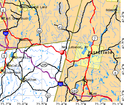
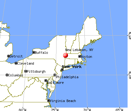
New Lebanon, New York
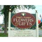
New Lebanon: Angel's Trumpet Flowers & Gifts, located on the corner of Rte. 20 and West Street in New Lebanon, NY
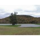
New Lebanon: Picturesque Field and Pond on Garfield Road in Stephentown, NY
- add
your
Submit your own pictures of this town and show them to the world
- OSM Map
- General Map
- Google Map
- MSN Map
Population change since 2000: -6.1%
 |
| Males: 1,185 | |
| Females: 1,120 |
| Median resident age: | 46.8 years |
| New York median age: | 40.7 years |
Zip codes: 12125.
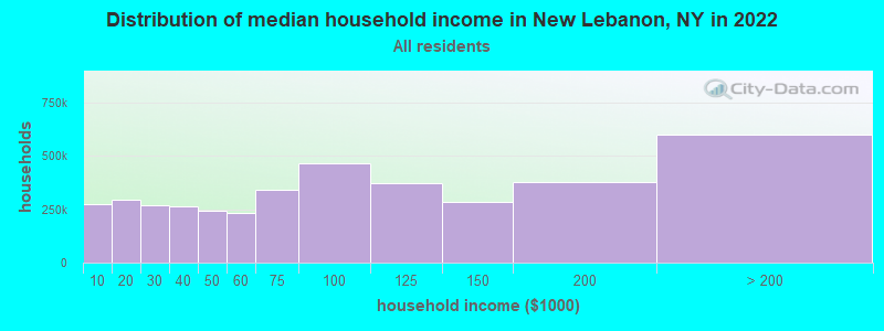
| New Lebanon: | $85,413 |
| NY: | $79,557 |
Estimated per capita income in 2022: $45,503 (it was $20,529 in 2000)
New Lebanon town income, earnings, and wages data
Estimated median house or condo value in 2022: $313,558 (it was $117,900 in 2000)
| New Lebanon: | $313,558 |
| NY: | $400,400 |
Mean prices in 2022: all housing units: $422,433; detached houses: $455,747; townhouses or other attached units: $597,881; in 2-unit structures: $391,116; in 3-to-4-unit structures: $525,972; in 5-or-more-unit structures: over $1,000,000; mobile homes: $85,716
Detailed information about poverty and poor residents in New Lebanon, NY
Compare current foreclosures near New Lebanon, NY:
| Photo | Address | Area | Beds / Baths | Price | Details |
|---|---|---|---|---|---|

|
#1
Crystal St
Lenox Dale, MA 01242
|
1,918 sq. feet
|
2 baths 3 beds |
$165,900
|
show details |

|
#2
Washington Mountain Rd
Lee, MA 01238
|
- sq. feet
|
1 baths 3 beds |
$155,000
|
show details |

|
#3
West St
Pittsfield, MA 01201
|
3,722 sq. feet
|
3 baths 6 beds |
show details | |

|
#4
Elberon Ave
Pittsfield, MA 01201
|
1,726 sq. feet
|
1 baths 3 beds |
show details | |

|
#5
Blue Factory Rd
Averill Park, NY 12018
|
1,344 sq. feet
|
2 baths 3 beds |
show details | |

|
#6
Daniels Ave
Pittsfield, MA 01201
|
3,040 sq. feet
|
3 baths 6 beds |
show details | |

|
#7
Green Ave
Castleton On Hudson, NY 12033
|
1,240 sq. feet
|
1 baths 4 beds |
show details | |

|
#8
Marion Blvd
Valatie, NY 12184
|
1,180 sq. feet
|
2 baths 3 beds |
show details | |

|
#9
Robbins Ave
Pittsfield, MA 01201
|
1,872 sq. feet
|
2 baths 4 beds |
show details | |

|
#10
Fenn St
Pittsfield, MA 01201
|
5,166 sq. feet
|
6 baths 12 beds |
show details |
| Photo | Address | Area | Beds / Baths | Price | Details |
|---|---|---|---|---|---|

|
#11
North St
Pittsfield, MA 01201
|
1,661 sq. feet
|
2 baths 4 beds |
show details | |

|
#12
Madison Ave
Pittsfield, MA 01201
|
2,192 sq. feet
|
2 baths 6 beds |
show details | |

|
#13
Weller Ave
Pittsfield, MA 01201
|
3,376 sq. feet
|
3 baths 6 beds |
show details | |

|
#14
Circular Ave
Pittsfield, MA 01201
|
2,808 sq. feet
|
4 baths 8 beds |
show details | |

|
#15
Wisconsin Ave
Rensselaer, NY 12144
|
1,432 sq. feet
|
3 baths 5 beds |
show details | |

|
#16
Holland Ln
Castleton On Hudson, NY 12033
|
1,375 sq. feet
|
1 baths 3 beds |
show details | |

|
#17
Morgan St
Lenox, MA 01240
|
3,959 sq. feet
|
2 baths 3 beds |
show details | |

|
#18
Ashuelot St
Dalton, MA 01226
|
1,792 sq. feet
|
2 baths 3 beds |
show details | |

|
#19
Augusta Dr
Castleton On Hudson, NY 12033
|
1,740 sq. feet
|
1 baths 2 beds |
show details | |

|
#20
Imperial Ave
Pittsfield, MA 01201
|
1,326 sq. feet
|
1 baths 3 beds |
show details |
| Photo | Address | Area | Beds / Baths | Price | Details |
|---|---|---|---|---|---|

|
#21
Route 203
Valatie, NY 12184
|
1,271 sq. feet
|
2 baths 3 beds |
show details | |

|
#22
Melville Ct
Lenox, MA 01240
|
3,988 sq. feet
|
6 baths 5 beds |
show details | |

|
#23
Kathy Way
Pittsfield, MA 01201
|
2,136 sq. feet
|
2 baths 3 beds |
show details | |

|
#24
Garfield Ave
Pittsfield, MA 01201
|
2,432 sq. feet
|
2 baths 4 beds |
show details | |

|
#25
Birds Hill Rd
Averill Park, NY 12018
|
1,128 sq. feet
|
1 baths 2 beds |
show details | |

|
#26
Ny Highway 150
West Sand Lake, NY 12196
|
1,632 sq. feet
|
2 baths 3 beds |
show details | |

|
#27
Old Coach Dr
Castleton On Hudson, NY 12033
|
2,613 sq. feet
|
2 baths 3 beds |
show details | |

|
#28
Tollgate Rd
Averill Park, NY 12018
|
2,088 sq. feet
|
2 baths 3 beds |
show details | |

|
#29
Janine Dr
East Greenbush, NY 12061
|
2,212 sq. feet
|
2 baths 4 beds |
show details | |

|
#30
Delaware Ave
Rensselaer, NY 12144
|
1,568 sq. feet
|
1 baths 2 beds |
show details |
| Photo | Address | Area | Beds / Baths | Price | Details |
|---|---|---|---|---|---|

|
#31
Brackwyck Dr
Rensselaer, NY 12144
|
1,232 sq. feet
|
1 baths 3 beds |
show details | |

|
#32
Adams Ave
Rensselaer, NY 12144
|
1,228 sq. feet
|
1 baths 3 beds |
show details | |

|
#33
Donna Lynn Dr
East Greenbush, NY 12061
|
841 sq. feet
|
1 baths 2 beds |
show details | |

|
#34
Boltwood Ave
Castleton On Hudson, NY 12033
|
952 sq. feet
|
1 baths 3 beds |
show details | |

|
#35
Chapel St
Lee, MA 01238
|
1,584 sq. feet
|
1 baths 3 beds |
show details | |

|
#36
Elliot Rd
East Greenbush, NY 12061
|
1,748 sq. feet
|
2 baths 3 beds |
show details | |

|
#37
Van Hoesen Rd
Castleton On Hudson, NY 12033
|
1,248 sq. feet
|
1 baths 3 beds |
show details | |

|
#38
Stockbridge Rd
Lee, MA 01238
|
4,695 sq. feet
|
4 baths 5 beds |
show details | |

|
#39
Brookview Rd
Castleton On Hudson, NY 12033
|
1,092 sq. feet
|
1 baths 2 beds |
show details | |

|
#40
County Route 21
Ghent, NY 12075
|
2,819 sq. feet
|
2 baths 6 beds |
show details |
| Photo | Address | Area | Beds / Baths | Price | Details |
|---|---|---|---|---|---|

|
#41
Elliot Rd
East Greenbush, NY 12061
|
2,840 sq. feet
|
2 baths 3 beds |
show details | |

|
#42
East St
Lee, MA 01238
|
1,478 sq. feet
|
2 baths 3 beds |
show details | |

|
#43
Pleasant St
East Greenbush, NY 12061
|
1,780 sq. feet
|
1 baths 4 beds |
show details | |

|
#44
North St
Dalton, MA 01226
|
1,852 sq. feet
|
2 baths 4 beds |
show details | |

|
#45
Roxbury Rd
Chatham, NY 12037
|
1,820 sq. feet
|
1 baths 3 beds |
show details | |

|
#46
Fawn Rdg
Castleton On Hudson, NY 12033
|
3,064 sq. feet
|
2 baths 3 beds |
show details | |

|
#47
Housatonic St
Lenox, MA 01240
|
1,380 sq. feet
|
1 baths 3 beds |
show details | |

|
#48
Beaver Rd
Nassau, NY 12123
|
1,144 sq. feet
|
1 baths 3 beds |
show details | |

|
#49
West St
Pittsfield, MA 01201
|
1,714 sq. feet
|
1 baths 4 beds |
show details | |

|
Check over 1 million property listings on Foreclosure.com!
|
browse all offers | |||

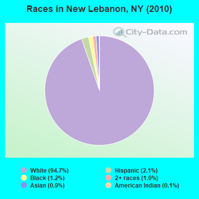
- 2,18294.7%White alone
- 492.1%Hispanic
- 281.2%Black alone
- 221.0%Two or more races
- 210.9%Asian alone
- 30.1%American Indian alone
Races in New Lebanon detailed stats: ancestries, foreign born residents, place of birth
 Recent articles from our blog. Our writers, many of them Ph.D. graduates or candidates, create easy-to-read articles on a wide variety of topics.

 | Why don't we have a Hudson Valley forum? (66 replies) |
| Downstate counties have highest rates of students in private schools. Check your district (3 replies) |
| smaller Upstate NY cities and towns/African American communities (5974 replies) |
| Which Westchester Districts Use Singapore Math? (7 replies) |
| Hudson Valley NY (80 replies) |
| Eastern Upstate NY or Western Massachusetts? (20 replies) |
Latest news from New Lebanon, NY collected exclusively by city-data.com from local newspapers, TV, and radio stations
Ancestries: German (19.8%), Irish (19.2%), English (16.9%), Italian (12.4%), French (9.3%), Dutch (5.9%).
Current Local Time: EST time zone
Land area: 35.9 square miles.
Population density: 64 people per square mile (very low).
104 residents are foreign born (3.0% Europe, 0.7% Latin America).
| This town: | 4.2% |
| New York: | 20.4% |
| New Lebanon town: | 1.9% ($2,202) |
| New York: | 1.9% ($2,847) |
Nearest city with pop. 50,000+: Albany, NY  (21.8 miles , pop. 95,658).
Nearest city with pop. 200,000+: Bronx, NY (114.2 miles , pop. 1,332,650).
Nearest cities:
), ), ), ), )Latitude: 42.47 N, Longitude: 73.44 W

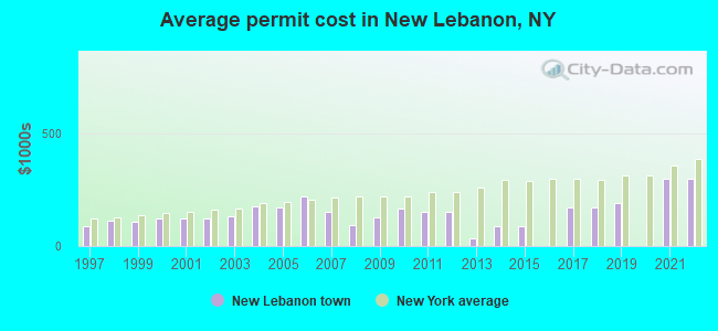
Single-family new house construction building permits:
- 2022: 8 buildings, average cost: $298,900
- 2021: 7 buildings, average cost: $298,900
- 2019: 5 buildings, average cost: $191,600
- 2018: 3 buildings, average cost: $170,000
- 2017: 3 buildings, average cost: $170,000
- 2015: 6 buildings, average cost: $85,800
- 2014: 6 buildings, average cost: $85,800
- 2013: 2 buildings, average cost: $32,500
- 2012: 1 building, cost: $150,000
- 2011: 1 building, cost: $150,000
- 2010: 3 buildings, average cost: $166,700
- 2009: 4 buildings, average cost: $125,000
- 2008: 3 buildings, average cost: $90,700
- 2007: 7 buildings, average cost: $148,600
- 2006: 8 buildings, average cost: $218,400
- 2005: 5 buildings, average cost: $172,000
- 2004: 12 buildings, average cost: $175,800
- 2003: 15 buildings, average cost: $129,800
- 2002: 9 buildings, average cost: $122,100
- 2001: 7 buildings, average cost: $122,100
- 2000: 9 buildings, average cost: $122,100
- 1999: 11 buildings, average cost: $107,400
- 1998: 7 buildings, average cost: $113,300
- 1997: 7 buildings, average cost: $89,100
| Here: | 3.2% |
| New York: | 4.4% |
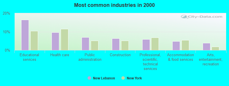
- Educational services (16.5%)
- Health care (9.6%)
- Public administration (7.0%)
- Construction (6.3%)
- Professional, scientific, technical services (5.9%)
- Accommodation & food services (4.8%)
- Arts, entertainment, recreation (3.8%)
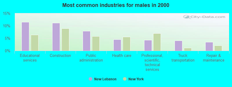
- Educational services (11.5%)
- Construction (11.1%)
- Public administration (7.9%)
- Health care (4.6%)
- Professional, scientific, technical services (4.3%)
- Truck transportation (4.1%)
- Repair & maintenance (3.4%)
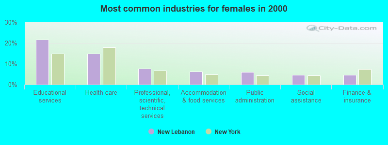
- Educational services (21.7%)
- Health care (14.8%)
- Professional, scientific, technical services (7.6%)
- Accommodation & food services (6.3%)
- Public administration (6.1%)
- Social assistance (4.8%)
- Finance & insurance (4.6%)
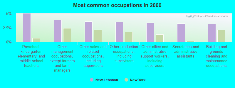
- Preschool, kindergarten, elementary, and middle school teachers (5.0%)
- Other management occupations, except farmers and farm managers (3.9%)
- Other sales and related occupations, including supervisors (3.6%)
- Other production occupations, including supervisors (3.5%)
- Other office and administrative support workers, including supervisors (3.4%)
- Secretaries and administrative assistants (3.2%)
- Building and grounds cleaning and maintenance occupations (3.2%)
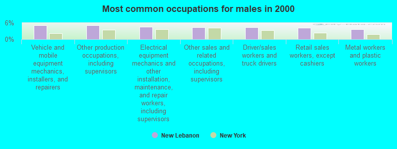
- Vehicle and mobile equipment mechanics, installers, and repairers (5.1%)
- Other production occupations, including supervisors (5.1%)
- Electrical equipment mechanics and other installation, maintenance, and repair workers, including supervisors (4.6%)
- Other sales and related occupations, including supervisors (4.4%)
- Driver/sales workers and truck drivers (4.4%)
- Retail sales workers, except cashiers (4.1%)
- Metal workers and plastic workers (3.6%)
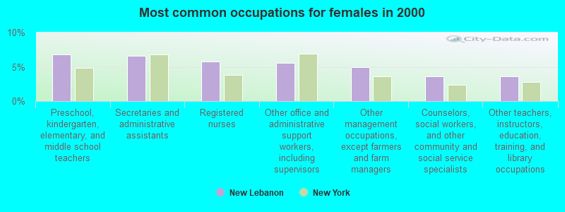
- Preschool, kindergarten, elementary, and middle school teachers (6.8%)
- Secretaries and administrative assistants (6.6%)
- Registered nurses (5.8%)
- Other office and administrative support workers, including supervisors (5.6%)
- Other management occupations, except farmers and farm managers (4.9%)
- Counselors, social workers, and other community and social service specialists (3.6%)
- Other teachers, instructors, education, training, and library occupations (3.6%)
Average climate in New Lebanon, New York
Based on data reported by over 4,000 weather stations


(lower is better)
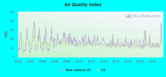
Air Quality Index (AQI) level in 2023 was 89.6. This is worse than average.
| City: | 89.6 |
| U.S.: | 72.6 |
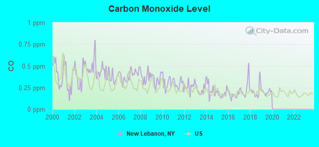
Carbon Monoxide (CO) [ppm] level in 2019 was 0.199. This is better than average. Closest monitor was 11.2 miles away from the city center.
| City: | 0.199 |
| U.S.: | 0.251 |
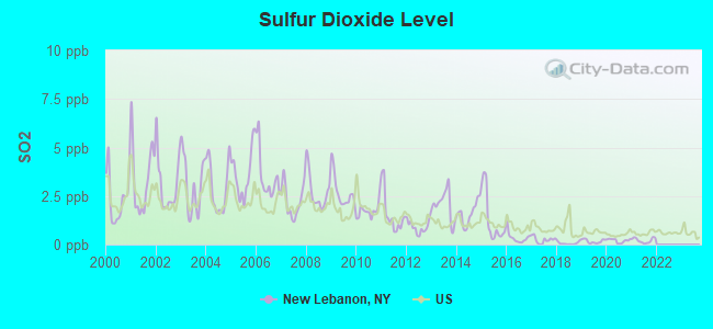
Sulfur Dioxide (SO2) [ppb] level in 2021 was 0.213. This is significantly better than average. Closest monitor was 10.4 miles away from the city center.
| City: | 0.213 |
| U.S.: | 1.515 |
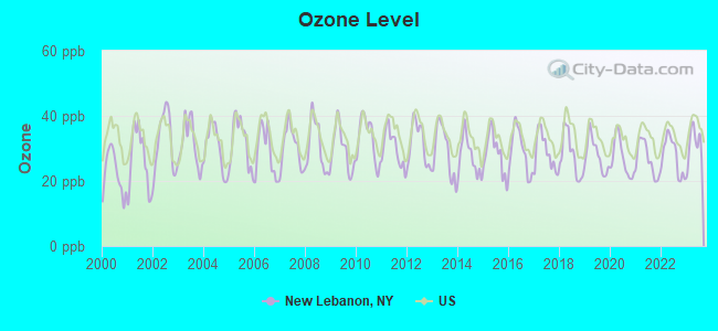
Ozone [ppb] level in 2023 was 31.1. This is about average. Closest monitor was 10.4 miles away from the city center.
| City: | 31.1 |
| U.S.: | 33.3 |
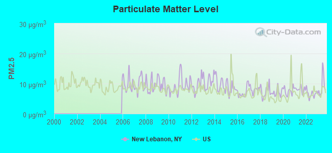
Particulate Matter (PM2.5) [µg/m3] level in 2023 was 9.02. This is about average. Closest monitor was 9.7 miles away from the city center.
| City: | 9.02 |
| U.S.: | 8.11 |
Tornado activity:
New Lebanon-area historical tornado activity is above New York state average. It is 25% smaller than the overall U.S. average.
On 8/28/1973, a category F4 (max. wind speeds 207-260 mph) tornado 3.4 miles away from the New Lebanon town center killed 4 people and injured 36 people and caused between $5,000,000 and $50,000,000 in damages.
On 5/29/1995, a category F4 tornado 18.5 miles away from the town center killed 3 people and injured 24 people and caused between $5,000,000 and $50,000,000 in damages.
Earthquake activity:
New Lebanon-area historical earthquake activity is significantly above New York state average. It is 68% smaller than the overall U.S. average.On 10/7/1983 at 10:18:46, a magnitude 5.3 (5.1 MB, 5.3 LG, 5.1 ML, Class: Moderate, Intensity: VI - VII) earthquake occurred 112.3 miles away from New Lebanon center
On 4/20/2002 at 10:50:47, a magnitude 5.3 (5.3 ML, Depth: 3.0 mi) earthquake occurred 142.1 miles away from the city center
On 4/20/2002 at 10:50:47, a magnitude 5.2 (5.2 MB, 4.2 MS, 5.2 MW, 5.0 MW) earthquake occurred 140.4 miles away from the city center
On 1/19/1982 at 00:14:42, a magnitude 4.7 (4.5 MB, 4.7 MD, 4.5 LG, Class: Light, Intensity: IV - V) earthquake occurred 117.5 miles away from the city center
On 10/16/2012 at 23:12:25, a magnitude 4.7 (4.7 ML, Depth: 10.0 mi) earthquake occurred 161.2 miles away from New Lebanon center
On 6/17/1991 at 08:53:16, a magnitude 4.1 (4.0 MB, 4.0 LG, Depth: 3.1 mi) earthquake occurred 63.9 miles away from the city center
Magnitude types: regional Lg-wave magnitude (LG), body-wave magnitude (MB), duration magnitude (MD), local magnitude (ML), surface-wave magnitude (MS), moment magnitude (MW)
Natural disasters:
The number of natural disasters in Columbia County (22) is greater than the US average (15).Major Disasters (Presidential) Declared: 12
Emergencies Declared: 9
Causes of natural disasters: Storms: 7, Floods: 6, Hurricanes: 4, Winter Storms: 4, Snowstorms: 3, Blizzards: 2, Power Outage: 1, Tornado: 1, Other: 2 (Note: some incidents may be assigned to more than one category).

Hospitals and medical centers near New Lebanon:
- SPRINGSIDE REHABILITATION AND SKILLED CARE CENTER (Nursing Home, about 8 miles away; PITTSFIELD, MA)
- BERKSHIRE VISITING NURSE ASSOCIATION (Home Health Center, about 9 miles away; PITTSFIELD, MA)
- HILLCREST HOSPITAL (Hospital, about 9 miles away; PITTSFIELD, MA)
- HILLCREST COMMONS NURSING AND REHABILITATION CENTER (Nursing Home, about 9 miles away; PITTSFIELD, MA)
- CENTER FOR OPTIMUM CARE-BERKSHIRE (Nursing Home, about 9 miles away; PITTSFIELD, MA)
- HOSPICE OF THE BERKSHIRES, INC (Hospital, about 10 miles away; PITTSFIELD, MA)
- BERKSHIRE PLACE (Nursing Home, about 10 miles away; PITTSFIELD, MA)
Amtrak stations near New Lebanon:
- 10 miles: PITTSFIELD (DEPOT ST. BTW NORTH & CENTER STS.) . Services: enclosed waiting area, public payphones, free short-term parking, free long-term parking, taxi stand, intercity bus service, public transit connection.
- 20 miles: ALBANY-RENSSELAER (RENSSELAER, 555 EAST ST.) . Services: ticket office, partially wheelchair accessible, enclosed waiting area, public restrooms, public payphones, snack bar, ATM, free short-term parking, free long-term parking, call for car rental service, taxi stand, public transit connection.
Colleges/universities with over 2000 students nearest to New Lebanon:
- Hudson Valley Community College (about 21 miles; Troy, NY; Full-time enrollment: 9,346)
- Williams College (about 21 miles; Williamstown, MA; FT enrollment: 2,141)
- Rensselaer Polytechnic Institute (about 22 miles; Troy, NY; FT enrollment: 6,940)
- The Sage Colleges (about 23 miles; Troy, NY; FT enrollment: 2,499)
- The College of Saint Rose (about 23 miles; Albany, NY; FT enrollment: 4,085)
- Siena College (about 24 miles; Loudonville, NY; FT enrollment: 3,153)
- SUNY at Albany (about 25 miles; Albany, NY; FT enrollment: 15,490)
Public high school in New Lebanon:
- NEW LEBANON JUNIOR-SENIOR HIGH SCHOOL (Students: 248, Location: 14665 RT 22, Grades: 7-12)
Private high school in New Lebanon:
- DARROW SCHOOL (Students: 114, Location: 110 DARROW RD, Grades: 9-12)
Public elementary/middle school in New Lebanon:
- WALTER B HOWARD ELEMENTARY SCHOOL (Students: 257, Location: 1478 RT 20, Grades: KG-6)
Private elementary/middle school in New Lebanon:
- MOUNTAIN ROAD SCHOOL (Students: 29, Location: 5 ABODE RD, Grades: PK-7)
Points of interest:
Notable locations in New Lebanon: Lebanon Valley Speedway (A), New Lebanon Library (B). Display/hide their locations on the map
Church in New Lebanon: New Lebanon Congregational Church (A). Display/hide its location on the map
Cemeteries: Immaculate Conception Cemetery (1), Mott Cemetery (2), Cornwall-Tilden Cemetery (3), Cemetery of the Evergreens (4). Display/hide their locations on the map
Lakes and swamps: Beaver Pond (A), Shaker Swamp (B). Display/hide their locations on the map
Streams, rivers, and creeks: Wyomanock Creek (A), Hollow Brook (B). Display/hide their locations on the map
Park in New Lebanon: Shafford Memorial Park (1). Display/hide its location on the map
Birthplace of: George Henry Williams - Lawyer, Phineas Hitchcock - Politician.
Drinking water stations with addresses in New Lebanon and their reported violations in the past:
MOUNTAIN ROAD CAMP (Address: 5 ABODE ROAD , Population served: 150, Groundwater):Past monitoring violations:JIMMY DS PIZZA ROYALE & REST. (Population served: 106, Groundwater):
- 5 routine major monitoring violations
- 3 regular monitoring violations
Past monitoring violations:MARIOS RESTAURANT (Address: ROUTE 22 NORTH , Population served: 81, Groundwater):
- 2 routine major monitoring violations
Past monitoring violations:HITCHIN POST CAFE (Population served: 50, Groundwater):
- 2 routine major monitoring violations
Past monitoring violations:
- 15 routine major monitoring violations
- 2 regular monitoring violations
| This town: | 2.2 people |
| New York: | 2.6 people |
| This town: | 59.4% |
| Whole state: | 63.5% |
| This town: | 10.4% |
| Whole state: | 6.8% |
Likely homosexual households (counted as self-reported same-sex unmarried-partner households)
- Lesbian couples: 0.8% of all households
- Gay men: 1.1% of all households
| This town: | 9.0% |
| Whole state: | 14.6% |
| This town: | 2.7% |
| Whole state: | 7.4% |
29 people in other noninstitutional facilities in 2010
People in group quarters in New Lebanon in 2000:
- 96 people in unknown juvenile institutions
- 16 people in religious group quarters
- 3 people in other nonhousehold living situations
Banks with branches in New Lebanon (2011 data):
- Bank of America, National Association: New Lebanon Branch at Routes 20+22, branch established on 1970/07/27. Info updated 2009/11/18: Bank assets: $1,451,969.3 mil, Deposits: $1,077,176.8 mil, headquarters in Charlotte, NC, positive income, 5782 total offices, Holding Company: Bank Of America Corporation
For population 15 years and over in New Lebanon:
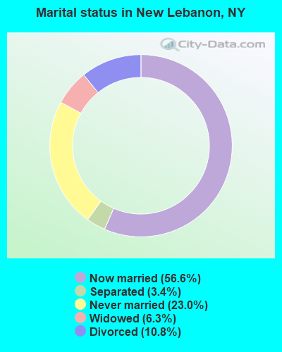
- Never married: 23.0%
- Now married: 56.6%
- Separated: 3.4%
- Widowed: 6.3%
- Divorced: 10.8%
For population 25 years and over in New Lebanon:
- High school or higher: 86.2%
- Bachelor's degree or higher: 28.0%
- Graduate or professional degree: 12.9%
- Unemployed: 5.1%
- Mean travel time to work (commute): 24.8 minutes
| Here: | 10.6 |
| New York average: | 14.2 |
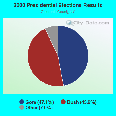
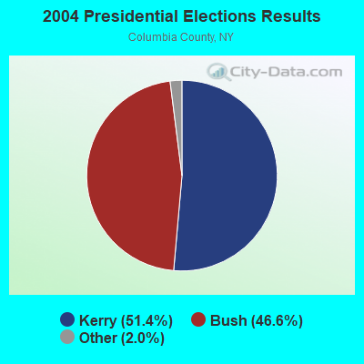
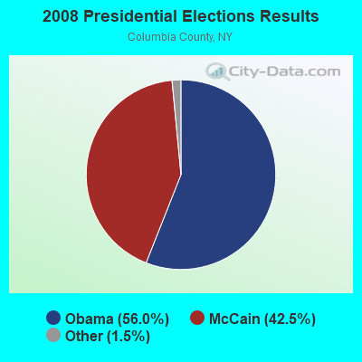

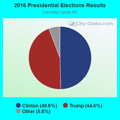
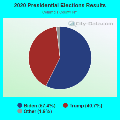
Graphs represent county-level data. Detailed 2008 Election Results
Religion statistics for New Lebanon, NY (based on Columbia County data)
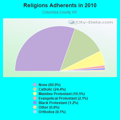
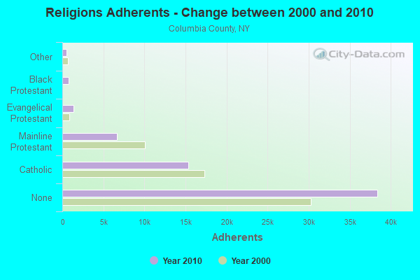
| Religion | Adherents | Congregations |
|---|---|---|
| Catholic | 15,375 | 11 |
| Mainline Protestant | 6,636 | 53 |
| Evangelical Protestant | 1,329 | 16 |
| Black Protestant | 776 | 3 |
| Other | 513 | 7 |
| Orthodox | 70 | 2 |
| None | 38,397 | - |
Food Environment Statistics:
| Columbia County: | 3.54 / 10,000 pop. |
| State: | 4.13 / 10,000 pop. |
| This county: | 0.80 / 10,000 pop. |
| State: | 0.92 / 10,000 pop. |
| This county: | 4.98 / 10,000 pop. |
| New York: | 1.68 / 10,000 pop. |
| Here: | 11.09 / 10,000 pop. |
| New York: | 8.82 / 10,000 pop. |
| This county: | 8.6% |
| New York: | 8.2% |
| Columbia County: | 27.0% |
| New York: | 23.8% |
| This county: | 17.1% |
| State: | 15.6% |
Businesses in New Lebanon, NY
- Ford: 1
- U-Haul: 1
Strongest AM radio stations in New Lebanon:
- WUHN (1110 AM; daytime; 5 kW; PITTSFIELD, MA; Owner: WEINER BROADCASTING, INC.)
- WNNZ (640 AM; 50 kW; WESTFIELD, MA; Owner: CLEAR CHANNEL BROADCASTING LICENSES, INC.)
- WGY (810 AM; 50 kW; SCHENECTADY, NY; Owner: CLEAR CHANNEL BROADCASTING LICENSES, INC.)
- WPTR (1540 AM; 50 kW; ALBANY, NY; Owner: KIMTRON, INC.)
- WROW (590 AM; 5 kW; ALBANY, NY; Owner: 6 JOHNSON ROAD LICENSES, INC.)
- WTIC (1080 AM; 50 kW; HARTFORD, CT; Owner: INFINITY RADIO OPERATIONS INC.)
- WTMM (1300 AM; 5 kW; RENSSELAER, NY; Owner: REGENT LICENSEE OF MANSFIELD, INC.)
- WBEC (1420 AM; 1 kW; PITTSFIELD, MA; Owner: GREAT NORTHERN RADIO, LLC)
- WCRN (830 AM; 50 kW; WORCESTER, MA; Owner: CARTER BROADCASTING CORPORATION)
- WSBS (860 AM; 3 kW; GREAT BARRINGTON, MA; Owner: BERKSHIRE BROADCASTING CO., INC.)
- WDDY (1460 AM; 5 kW; ALBANY, NY)
- WVNE (760 AM; daytime; 25 kW; LEICESTER, MA; Owner: BLOUNT MASSCOM, INC.)
- WOFX (980 AM; 5 kW; TROY, NY)
Strongest FM radio stations in New Lebanon:
- WHVP (91.1 FM; HUDSON, NY; Owner: SOUND OF LIFE, INC.)
- WAMC-FM (90.3 FM; ALBANY, NY; Owner: WAMC)
- WBEC-FM (105.5 FM; PITTSFIELD, MA; Owner: GREAT NORTHERN RADIO, LLC)
- WUPE (95.9 FM; PITTSFIELD, MA; Owner: WEINER BROADCASTING, INC.)
- WZEC (97.5 FM; HOOSICK FALLS, NY; Owner: GREAT NORTHERN RADIO, LLC)
- WAMQ (105.1 FM; GREAT BARRINGTON, MA; Owner: WAMC)
- WEQX (102.7 FM; MANCHESTER, VT; Owner: NORTHSHIRE COMMUNICATIONS, INC.)
- WJAN (95.1 FM; SUNDERLAND, VT; Owner: 6 JOHNSON ROAD LICENSES, INC.)
- WAJZ (96.3 FM; VOORHEESVILLE, NY; Owner: 6 JOHNSON ROAD LICENSES, INC.)
- WZMR (104.9 FM; ALTAMONT, NY; Owner: 6 JOHNSON ROAD LICENSES, INC.)
- WYJB (95.5 FM; ALBANY, NY; Owner: 6 JOHNSON ROAD LICENSES, INC.)
- WGNA-FM (107.7 FM; ALBANY, NY; Owner: REGENT LICENSEE OF MANSFIELD, INC.)
- WAMK (90.9 FM; KINGSTON, NY; Owner: W A M C)
- WVAY (100.7 FM; WILMINGTON, VT; Owner: GREAT NORTHERN RADIO, L.L.C.)
- WFGB (89.7 FM; KINGSTON, NY; Owner: SOUND OF LIFE, INC.)
- WRVE (99.5 FM; SCHENECTADY, NY; Owner: CLEAR CHANNEL BROADCASTING LICENSES, INC.)
- WMHT-FM (89.1 FM; SCHENECTADY, NY; Owner: WMHT EDUCATIONAL TELECOMMUNICATIONS)
- WPYX (106.5 FM; ALBANY, NY; Owner: CAPSTAR TX LIMITED PARTNERSHIP)
- WVCR-FM (88.3 FM; LOUDONVILLE, NY; Owner: SIENA COLLEGE)
- WFLY (92.3 FM; TROY, NY; Owner: 6 JOHNSON ROAD LICENSES, INC.)
TV broadcast stations around New Lebanon:
- WNYT (Channel 13; ALBANY, NY; Owner: WNYT-TV, LLC)
- WRGB (Channel 6; SCHENECTADY, NY; Owner: FREEDOM BROADCASTING OF NEW YORK, INC)
- WCDC-TV (Channel 19; ADAMS, MA; Owner: YOUNG BROADCASTING OF ALBANY, INC.)
- WNGN-LP (Channel 26; TROY, NY; Owner: BRIAN A. LARSON)
- W38DL (Channel 38; ADAMS, ETC., MA; Owner: WNYT-TV, LLC)
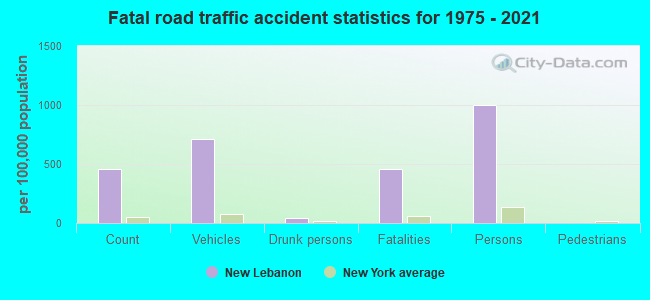
- National Bridge Inventory (NBI) Statistics
- 18Number of bridges
- 79ft / 23.9mTotal length
- $20,839,000Total costs
- 27,104Total average daily traffic
- 2,563Total average daily truck traffic
- 28,858Total future (year 2035) average daily traffic
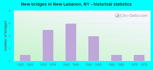
- New bridges - historical statistics
- 11920-1929
- 51930-1939
- 61940-1949
- 41950-1959
- 11960-1969
- 11970-1979
FCC Registered Cell Phone Towers:
1- 1123 Us Route 20 (Lat: 42.479500 Lon: -73.447694), Type: Mtower, Structure height: 44.2 m, Overall height: 45.7 m, Call Sign: KNKN512, Licensee ID: L00128694
Assigned Frequencies: 869.040 MHz, 869.040 MHz, 869.040 MHz, 824.040 MHz, 824.040 MHz, 824.040 MHz, 890.010 MHz, 890.010 MHz, 890.010 MHz, 845.010 MHz, 845.010 MHz, 845.010 MHzGrant Date: 09/01/2020, Expiration Date: 10/01/2030, Certifier: Michael P GogginRegistrant: New Cingular Wireless Pcs, LLC
FCC Registered Antenna Towers:
4- Curtis L Miller, Ny1031 New Lebanon - 1123 Rt. 20 (Lat: 42.480500 Lon: -73.446417), Type: 33.5, Overall height: 33.5 m, Registrant: Florida Tower Partners, LLC Dba North Atlantic Towers, Cmiller@tarpontowers.Com, , Brade-nton, Phone: (941) 757-5010
- Todd J Bowman, Ny1031 New Lebanon - 1123 Rt. 20 (Lat: 42.480500 Lon: -73.446417), Type: 33.5, Overall height: 33.5 m, Registrant: Florida Tower Partners, LLC Dba North Atlantic Towers, Cmiller@tarpontowers.Com, , Brade-nton, Phone: (941) 757-5010
- Bridget Carter, Ny1031 New Lebanon - 1123 Rt. 20 (Lat: 42.480500 Lon: -73.446417), Type: 33.5, Structure height: 36021 m, Overall height: 33.5 m, Registrant: Spectrasite Communications, LLC. Through American Towers, LLC., Faa-Fcc@americantower.Com, , Wobur-n, Phone: (678) 265-6770
- Jacob T Chapman, Ny1031 New Lebanon - 1123 Rt. 20 (Lat: 42.480500 Lon: -73.446417), Type: 33.5, Structure height: 36021 m, Overall height: 33.5 m, Registrant: American Towers LLC, Faa-Fcc@americantower.Com, , Wobur-n, Phone: (781) 926-4500
FCC Registered Broadcast Land Mobile Towers:
6- New Lebanon Tower, 2069 Route 5 (Lat: 42.445194 Lon: -73.449306), Type: Ltower, Structure height: 57.9 m, Call Sign: KQR426,
Assigned Frequencies: 159.165 MHz, Grant Date: 10/21/2020, Expiration Date: 01/02/2031, Registrant: 85 Industrial Tract, Hudson, NY 12534, Phone: (518) 828-1263, Fax: (518) 828-9088, Email:
- New Lebanon Tower, 2069 Route 5 (Lat: 42.445194 Lon: -73.449306), Type: Ltower, Structure height: 57.9 m, Call Sign: KNDS856,
Assigned Frequencies: 154.025 MHz, Grant Date: 03/19/2024, Expiration Date: 06/10/2034, Registrant: 85 Industrial Tract, Hudson, NY 12534, Phone: (518) 828-1263, Fax: (518) 828-9088, Email:
- 14776 Route 22 (Lat: 42.475833 Lon: -73.382222), Type: Building, Structure height: 7 m, Call Sign: WPXQ696,
Assigned Frequencies: 159.697 MHz, Grant Date: 05/22/2013, Expiration Date: 05/21/2023, Cancellation Date: 07/22/2023, Certifier: Andrew Sandstrom, Registrant: Business Radio Licensing, 30251 Golden Lantern Suite E #501, Laguna Niguel, CA 92677, Phone: (949) 348-8510, Fax: (949) 348-8514, Email:
- SP NEW LEBANON, Nysp Station, Po Box 86, Route 20 (Lat: 42.470278 Lon: -73.383056), Type: Bant, Structure height: 6 m, Overall height: 12 m, Call Sign: WQCB544,
Assigned Frequencies: 154.695 MHz, Grant Date: 12/29/2014, Expiration Date: 01/24/2025, Certifier: Carl W Carlton, Registrant: New York State Police, 1220 Washington Ave, Bldg 22, Albany, NY 12226-2252, Phone: (518) 457-9466, Fax: (518) 457-5676, Email:
- New Lebanon Tower, 2069 Route 5 (Lat: 42.445194 Lon: -73.449306), Type: Ltower, Structure height: 57.9 m, Call Sign: WRZS645,
Assigned Frequencies: 154.452 MHz, 155.752 MHz, 453.212 MHz, 453.462 MHz, 151.137 MHz, 453.712 MHz, 158.737 MHz, 453.862 MHz, 159.472 MHz, Grant Date: 12/05/2023, Expiration Date: 12/05/2033, Certifier: Robert C Lopez, Registrant: Columbia County 911, 85 Industrial Tract, Hudson, NY 12534, Phone: (518) 828-1263, Fax: (518) 828-9088, Email:
- New Lebanon Tower, 2069 Route 5 (Lat: 42.445194 Lon: -73.449306), Type: Ltower, Structure height: 57.9 m, Call Sign: WRZU559, Licensee ID: L00001305,
Assigned Frequencies: 155.430 MHz, 155.295 MHz, Grant Date: 12/12/2023, Expiration Date: 12/12/2033, Certifier: Robert C Lopez, Registrant: County Of Columbia, 85 Industrial Tract, Hudson, NY 12534, Phone: (518) 828-1263, Email:
FCC Registered Microwave Towers:
30 (See the full list of FCC Registered Microwave Towers in this town)FCC Registered Amateur Radio Licenses:
6- Call Sign: KC2EZQ, Grant Date: 04/28/1999, Expiration Date: 04/28/2009, Cancellation Date: 04/29/2011, Registrant: Jeffry B Sheldon, New Lebanon, NY 12125
- Call Sign: W2FK, Licensee ID: L01069903, Grant Date: 10/06/2015, Expiration Date: 11/28/2025, Certifier: Michael J Lankin, Registrant: Michael J Lankin, New Lebanon, NY 12125
- Call Sign: WA1NTW, Grant Date: 03/27/1995, Expiration Date: 03/27/2005, Cancellation Date: 03/28/2007, Registrant: Judith C Johnson, Shaker Rd, New Lebanon, NY 12125
- Call Sign: KC2ZKJ, Licensee ID: L01603408, Grant Date: 09/17/2020, Expiration Date: 11/17/2030, Certifier: Merrill S Ross, Registrant: Merrill S Ross, 39 Temple Rd, New Lebanon, NY 12125
- Call Sign: KD2GYU, Licensee ID: L01025388, Grant Date: 07/25/2014, Expiration Date: 07/25/2024, Certifier: Thomas E Lightburn, Registrant: Thomas E Lightburn, 110 Darrow Rd, New Lebanon, NY 12125
- Call Sign: N1DEG, Previous Call Sign: KC1AJX, Licensee ID: L00792167, Grant Date: 09/15/2018, Expiration Date: 09/15/2028, Certifier: Darrin E Garrison, Registrant: Darrin E Garrison, 14598 State Route 22, New Lebanon, NY 12125
2003 - 2018 National Fire Incident Reporting System (NFIRS) incidents
- Fire incident types reported to NFIRS in New Lebanon, NY
- 17760.0%Structure Fires
- 9331.5%Outside Fires
- 155.1%Mobile Property/Vehicle Fires
- 103.4%Other
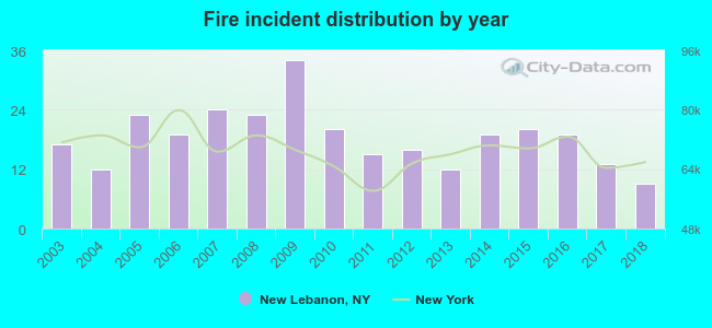 According to the data from the years 2003 - 2018 the average number of fires per year is 18. The highest number of fire incidents - 34 took place in 2009, and the least - 9 in 2018. The data has a decreasing trend.
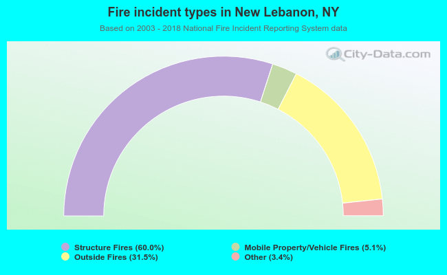 When looking into fire subcategories, the most incidents belonged to: Structure Fires (60.0%), and Outside Fires (31.5%).
| Most common first names in New Lebanon, NY among deceased individuals | ||
| Name | Count | Lived (average) |
|---|---|---|
| Charles | 8 | 81.2 years |
| William | 8 | 76.0 years |
| John | 8 | 79.4 years |
| Margaret | 6 | 75.2 years |
| Elizabeth | 6 | 73.8 years |
| George | 5 | 72.6 years |
| Helen | 5 | 81.6 years |
| Arthur | 5 | 74.2 years |
| Robert | 4 | 82.5 years |
| Mary | 4 | 84.0 years |
| Most common last names in New Lebanon, NY among deceased individuals | ||
| Last name | Count | Lived (average) |
|---|---|---|
| Cummings | 5 | 67.4 years |
| Miller | 4 | 79.8 years |
| Reynolds | 4 | 79.0 years |
| Bergdoll | 3 | 78.0 years |
| Koepp | 3 | 82.7 years |
| Johnson | 3 | 86.3 years |
| Lasher | 3 | 86.7 years |
| Hansen | 3 | 76.0 years |
| Thomas | 3 | 66.3 years |
| Sherman | 3 | 79.0 years |
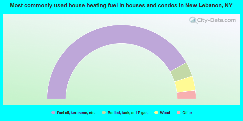
- 83.6%Fuel oil, kerosene, etc.
- 6.3%Bottled, tank, or LP gas
- 6.3%Wood
- 3.3%Electricity
- 0.4%Utility gas
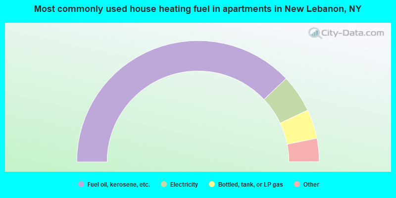
- 75.9%Fuel oil, kerosene, etc.
- 10.1%Electricity
- 7.8%Bottled, tank, or LP gas
- 3.5%Wood
- 1.6%Coal or coke
- 1.2%Other fuel
New Lebanon compared to New York state average:
- Unemployed percentage significantly below state average.
- Black race population percentage significantly below state average.
- Hispanic race population percentage significantly below state average.
- Median age above state average.
- Foreign-born population percentage significantly below state average.
- Renting percentage below state average.
- Length of stay since moving in significantly above state average.
- Number of rooms per house significantly below state average.
- House age significantly below state average.
- Institutionalized population percentage above state average.
- Number of college students below state average.
New Lebanon on our top lists:
- #10 on the list of "Top 101 cities with the largest percentage of people in unknown juvenile institutions (population 1,000+)"
- #73 on the list of "Top 101 counties with the lowest total withdrawal of fresh water for public supply (pop. 50,000+)"
- #81 on the list of "Top 101 counties with the lowest surface withdrawal of fresh water for public supply (pop. 50,000+)"

|
Total of 6 patent applications in 2008-2024.