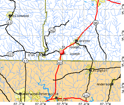
St. Joseph, Tennessee
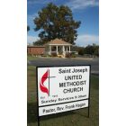
St. Joseph: Saint Joseph United Methodist Church, 301 North Main Street, Saint Joseph TN 38481
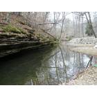
St. Joseph: View in the St. Joseph, Tennessee City Park
- add
your
Submit your own pictures of this city and show them to the world
- OSM Map
- General Map
- Google Map
- MSN Map
Population change since 2000: -2.5%
 |
| Males: 432 | |
| Females: 376 |
| Median resident age: | 39.9 years |
| Tennessee median age: | 39.2 years |
Zip codes: 38481.
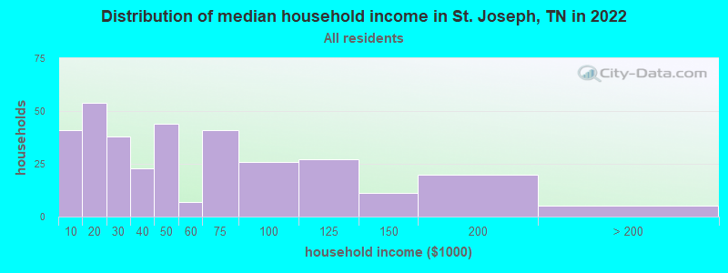
| St. Joseph: | $41,767 |
| TN: | $65,254 |
Estimated per capita income in 2022: $30,351 (it was $13,038 in 2000)
St. Joseph city income, earnings, and wages data
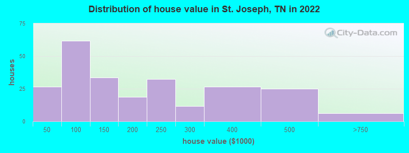
Estimated median house or condo value in 2022: $150,805 (it was $53,800 in 2000)
| St. Joseph: | $150,805 |
| TN: | $284,800 |
Mean prices in 2022: all housing units: $161,942; detached houses: $183,949; mobile homes: $39,678
Median gross rent in 2022: $606.
(16.7% for White Non-Hispanic residents, 100.0% for Hispanic or Latino residents, 46.2% for two or more races residents)
Detailed information about poverty and poor residents in St. Joseph, TN
Compare current foreclosures near St. Joseph, TN:
| Photo | Address | Area | Beds / Baths | Price | Details |
|---|---|---|---|---|---|

|
#1
County Road 601
Rogersville, AL 35652
|
1,100 sq. feet
|
1 baths 3 beds |
show details | |

|
#2
County Road 584
Rogersville, AL 35652
|
1,568 sq. feet
|
1 baths - beds |
show details | |

|
#3
Dunolly Ln
Florence, AL 35633
|
1,772 sq. feet
|
2 baths - beds |
show details | |

|
#4
Dunolly Ln
Florence, AL 35633
|
1,810 sq. feet
|
2 baths - beds |
show details | |

|
#5
Middle Butler Rd
Collinwood, TN 38450
|
1,600 sq. feet
|
1 baths - beds |
show details | |

|
#6
Commanche Cir
Collinwood, TN 38450
|
1,425 sq. feet
|
2 baths - beds |
show details | |

|
#7
Mary Lee Dr
Florence, AL 35634
|
1,595 sq. feet
|
2 baths - beds |
show details | |

|
#8
Eastwood Dr
Florence, AL 35630
|
1,056 sq. feet
|
1 baths - beds |
show details | |

|
#9
Dogwood Dr
Florence, AL 35630
|
1,080 sq. feet
|
1 baths - beds |
show details | |

|
#10
Walnut Creek Rd
Killen, AL 35645
|
1,965 sq. feet
|
2 baths - beds |
show details |
| Photo | Address | Area | Beds / Baths | Price | Details |
|---|---|---|---|---|---|

|
#11
E Dixon St
Collinwood, TN 38450
|
1,341 sq. feet
|
1 baths - beds |
show details | |

|
#12
Shady Ln
Lawrenceburg, TN 38464
|
3,138 sq. feet
|
2 baths - beds |
show details | |

|
#13
White Oak Dr
Leoma, TN 38468
|
1,360 sq. feet
|
2 baths - beds |
show details | |

|
#14
Mabry Ln
Loretto, TN 38469
|
1,770 sq. feet
|
1 baths - beds |
show details | |

|
#15
Grandaddy Rd
Lawrenceburg, TN 38464
|
1,123 sq. feet
|
1 baths - beds |
show details | |

|
#16
Factors Fork Rd
Westpoint, TN 38486
|
1,264 sq. feet
|
1 baths - beds |
show details | |

|
#17
Glenn Springs Rd
Lawrenceburg, TN 38464
|
960 sq. feet
|
2 baths - beds |
show details | |

|
#18
Highway 101
Rogersville, AL 35652
|
1,593 sq. feet
|
1 baths - beds |
show details | |

|
#19
Frances Dr
Killen, AL 35645
|
1,726 sq. feet
|
2 baths - beds |
show details | |

|
#20
Roxie Dr
Florence, AL 35633
|
2,550 sq. feet
|
2 baths - beds |
show details |
| Photo | Address | Area | Beds / Baths | Price | Details |
|---|---|---|---|---|---|

|
#21
Plantation Dr
Killen, AL 35645
|
2,016 sq. feet
|
2 baths - beds |
show details | |

|
#22
Brandenburg Dr
Florence, AL 35634
|
1,653 sq. feet
|
2 baths - beds |
show details | |

|
#23
Summers Dr
Florence, AL 35634
|
1,512 sq. feet
|
2 baths - beds |
show details | |

|
#24
School St
Saint Joseph, TN 38481
|
3,566 sq. feet
|
1 baths - beds |
show details | |

|
#25
Williams Hollow Rd
Iron City, TN 38463
|
1,025 sq. feet
|
1 baths - beds |
show details | |

|
#26
Ezell Ln
Loretto, TN 38469
|
852 sq. feet
|
1 baths - beds |
show details | |

|
#27
S Military St
Loretto, TN 38469
|
1,440 sq. feet
|
1 baths - beds |
show details | |

|
#28
Chestnut Ln
Lawrenceburg, TN 38464
|
1,488 sq. feet
|
2 baths - beds |
show details | |

|
#29
County Road 159
Lexington, AL 35648
|
384 sq. feet
|
1 baths - beds |
show details | |

|
#30
Marable Rd
Lawrenceburg, TN 38464
|
1,172 sq. feet
|
1 baths - beds |
show details |
| Photo | Address | Area | Beds / Baths | Price | Details |
|---|---|---|---|---|---|

|
#31
County Road 388
Killen, AL 35645
|
1,837 sq. feet
|
2 baths - beds |
show details | |

|
#32
Railroad Bed Rd
Iron City, TN 38463
|
1,570 sq. feet
|
1 baths - beds |
show details | |

|
#33
Camelot Way
Florence, AL 35633
|
1,771 sq. feet
|
2 baths - beds |
show details | |

|
#34
County Road 531
Anderson, AL 35610
|
2,146 sq. feet
|
4 baths - beds |
show details | |

|
#35
Dunn Rd
Leoma, TN 38468
|
1,056 sq. feet
|
1 baths - beds |
show details | |

|
#36
Shelton Dr
Saint Joseph, TN 38481
|
1,272 sq. feet
|
1 baths - beds |
show details | |

|
#37
Old Jackson Hwy
Loretto, TN 38469
|
1,616 sq. feet
|
1 baths - beds |
show details | |

|
#38
N Eclipse St
Florence, AL 35630
|
1,064 sq. feet
|
1 baths - beds |
show details | |

|
#39
County Road 47
Florence, AL 35634
|
1,344 sq. feet
|
2 baths - beds |
show details | |

|
#40
Highway 72
Rogersville, AL 35652
|
- sq. feet
|
- baths - beds |
show details |
| Photo | Address | Area | Beds / Baths | Price | Details |
|---|---|---|---|---|---|

|
#41
Pine Brook Dr
Florence, AL 35633
|
- sq. feet
|
- baths - beds |
show details | |

|
#42
County Road 7
Florence, AL 35633
|
1,552 sq. feet
|
- baths - beds |
show details | |

|
#43
Chisholm Rd # 1204
Florence, AL 35630
|
- sq. feet
|
- baths - beds |
show details | |

|
#44
Chisholm Rd # 1205
Florence, AL 35630
|
- sq. feet
|
- baths - beds |
show details | |

|
#45
Mars Hill Rd
Florence, AL 35630
|
- sq. feet
|
- baths - beds |
show details | |

|
#46
Deer Brooke Ln
Florence, AL 35630
|
- sq. feet
|
- baths - beds |
show details | |

|
#47
Woodcastle Dr
Florence, AL 35630
|
- sq. feet
|
- baths - beds |
show details | |

|
#48
Estella Ct # 304e
Florence, AL 35630
|
- sq. feet
|
- baths - beds |
show details | |

|
#49
County Road 7
Florence, AL 35633
|
- sq. feet
|
- baths - beds |
show details | |

|
Check over 1 million property listings on Foreclosure.com!
|
browse all offers | |||


- 73091.4%White alone
- 263.3%Two or more races
- 212.6%Asian alone
- 70.9%Black alone
- 60.8%Other race alone
- 60.8%Hispanic
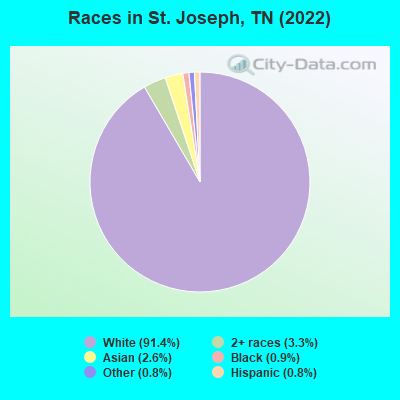
Races in St. Joseph detailed stats: ancestries, foreign born residents, place of birth
According to our research of Tennessee and other state lists, there were 3 registered sex offenders living in St. Joseph, Tennessee as of May 10, 2024.
The ratio of all residents to sex offenders in St. Joseph is 293 to 1.
The ratio of registered sex offenders to all residents in this city is near the state average.
Type |
2009 |
2010 |
2011 |
2012 |
2013 |
2014 |
2015 |
2016 |
2017 |
2018 |
2019 |
2020 |
2021 |
2022 |
|---|---|---|---|---|---|---|---|---|---|---|---|---|---|---|
| Murders (per 100,000) | 0 (0.0) | 0 (0.0) | 0 (0.0) | 0 (0.0) | 0 (0.0) | 0 (0.0) | 0 (0.0) | 0 (0.0) | 0 (0.0) | 0 (0.0) | 0 (0.0) | 0 (0.0) | 0 (0.0) | 0 (0.0) |
| Rapes (per 100,000) | 0 (0.0) | 0 (0.0) | 0 (0.0) | 1 (125.9) | 0 (0.0) | 0 (0.0) | 0 (0.0) | 0 (0.0) | 0 (0.0) | 0 (0.0) | 0 (0.0) | 0 (0.0) | 0 (0.0) | 0 (0.0) |
| Robberies (per 100,000) | 0 (0.0) | 0 (0.0) | 0 (0.0) | 0 (0.0) | 0 (0.0) | 0 (0.0) | 0 (0.0) | 0 (0.0) | 0 (0.0) | 0 (0.0) | 0 (0.0) | 0 (0.0) | 0 (0.0) | 0 (0.0) |
| Assaults (per 100,000) | 1 (116.4) | 0 (0.0) | 9 (1,141) | 6 (755.7) | 0 (0.0) | 0 (0.0) | 0 (0.0) | 2 (252.8) | 0 (0.0) | 0 (0.0) | 1 (122.9) | 1 (120.0) | 3 (362.8) | 0 (0.0) |
| Burglaries (per 100,000) | 6 (698.5) | 2 (255.8) | 7 (887.2) | 7 (881.6) | 3 (380.7) | 5 (641.8) | 2 (254.5) | 1 (126.4) | 2 (253.2) | 0 (0.0) | 3 (368.6) | 3 (360.1) | 2 (241.8) | 1 (122.9) |
| Thefts (per 100,000) | 7 (814.9) | 13 (1,662) | 5 (633.7) | 5 (629.7) | 13 (1,650) | 6 (770.2) | 2 (254.5) | 5 (632.1) | 0 (0.0) | 1 (123.3) | 2 (245.7) | 3 (360.1) | 8 (967.4) | 5 (614.3) |
| Auto thefts (per 100,000) | 1 (116.4) | 2 (255.8) | 3 (380.2) | 1 (125.9) | 1 (126.9) | 0 (0.0) | 0 (0.0) | 0 (0.0) | 0 (0.0) | 0 (0.0) | 1 (122.9) | 2 (240.1) | 1 (120.9) | 0 (0.0) |
| Arson (per 100,000) | 0 (0.0) | 1 (127.9) | 0 (0.0) | 1 (125.9) | 0 (0.0) | 0 (0.0) | 0 (0.0) | 0 (0.0) | 0 (0.0) | 0 (0.0) | 0 (0.0) | 0 (0.0) | 0 (0.0) | 0 (0.0) |
| City-Data.com crime index | 114.1 | 104.9 | 346.0 | 348.9 | 102.8 | 75.7 | 28.0 | 84.7 | 17.7 | 4.9 | 70.0 | 82.8 | 137.8 | 33.2 |
The City-Data.com crime index weighs serious crimes and violent crimes more heavily. Higher means more crime, U.S. average is 246.1. It adjusts for the number of visitors and daily workers commuting into cities.
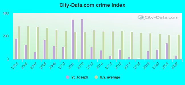
Crime rate in St. Joseph detailed stats: murders, rapes, robberies, assaults, burglaries, thefts, arson
Full-time law enforcement employees in 2021, including police officers: 1 (1 officers - 1 male; 0 female).
| Officers per 1,000 residents here: | 1.21 |
| Tennessee average: | 2.57 |
 Recent articles from our blog. Our writers, many of them Ph.D. graduates or candidates, create easy-to-read articles on a wide variety of topics.

 | Mount Juliet versus Hendersonville (95 replies) |
| News, 5 Cities Where Poverty is Soaring, Cookeville on the list. (16 replies) |
| Looking for a small safe town in Tennessee to raise our kids (13 replies) |
| African American Family Relocating to Knoxville area (27 replies) |
| What is your favorite thing in Knoxville? (26 replies) |
| Nashville of the past, 90's and before (104 replies) |
Latest news from St. Joseph, TN collected exclusively by city-data.com from local newspapers, TV, and radio stations
Ancestries: American (41.1%), Irish (9.1%), English (8.9%), European (2.9%), Italian (2.9%), German (2.3%).
Current Local Time: CST time zone
Incorporated in 1870
Elevation: 795 feet
Land area: 3.59 square miles.
Population density: 225 people per square mile (very low).
20 residents are foreign born (1.8% Asia, 0.8% Latin America).
| This city: | 2.5% |
| Tennessee: | 5.4% |
Median real estate property taxes paid for housing units with mortgages in 2022: $611 (0.4%)
Median real estate property taxes paid for housing units with no mortgage in 2022: $944 (0.5%)
Nearest city with pop. 50,000+: Decatur, AL  (43.1 miles , pop. 53,929).
Nearest city with pop. 200,000+: Nashville-Davidson, TN (87.9 miles , pop. 545,524).
Nearest city with pop. 1,000,000+: Chicago, IL (470.8 miles , pop. 2,896,016).
Nearest cities:
), ), )Latitude: 35.03 N, Longitude: 87.50 W
Area code commonly used in this area: 931

| Here: | 3.1% |
| Tennessee: | 3.0% |
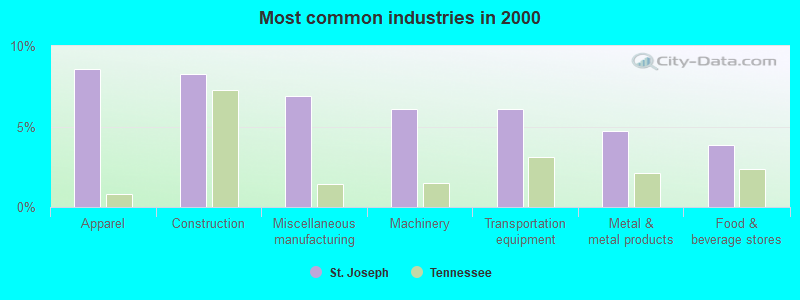
- Apparel (8.6%)
- Construction (8.3%)
- Miscellaneous manufacturing (6.9%)
- Machinery (6.1%)
- Transportation equipment (6.1%)
- Metal & metal products (4.7%)
- Food & beverage stores (3.9%)
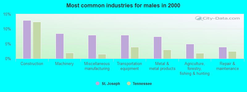
- Construction (12.9%)
- Machinery (8.5%)
- Miscellaneous manufacturing (8.0%)
- Transportation equipment (8.0%)
- Metal & metal products (7.5%)
- Agriculture, forestry, fishing & hunting (5.0%)
- Repair & maintenance (4.0%)
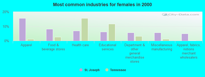
- Apparel (15.5%)
- Food & beverage stores (8.1%)
- Health care (6.8%)
- Educational services (6.2%)
- Department & other general merchandise stores (5.6%)
- Miscellaneous manufacturing (5.6%)
- Apparel, fabrics, notions merchant wholesalers (5.0%)
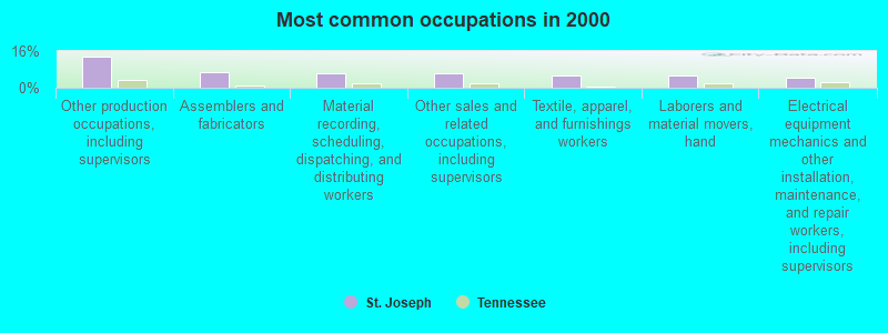
- Other production occupations, including supervisors (13.5%)
- Assemblers and fabricators (6.9%)
- Material recording, scheduling, dispatching, and distributing workers (6.4%)
- Other sales and related occupations, including supervisors (6.1%)
- Textile, apparel, and furnishings workers (5.5%)
- Laborers and material movers, hand (5.2%)
- Electrical equipment mechanics and other installation, maintenance, and repair workers, including supervisors (4.4%)
- Other production occupations, including supervisors (11.9%)
- Material recording, scheduling, dispatching, and distributing workers (8.5%)
- Electrical equipment mechanics and other installation, maintenance, and repair workers, including supervisors (8.0%)
- Assemblers and fabricators (7.5%)
- Vehicle and mobile equipment mechanics, installers, and repairers (7.0%)
- Metal workers and plastic workers (6.5%)
- Driver/sales workers and truck drivers (6.5%)
- Other production occupations, including supervisors (15.5%)
- Textile, apparel, and furnishings workers (11.2%)
- Other sales and related occupations, including supervisors (10.6%)
- Assemblers and fabricators (6.2%)
- Cashiers (5.6%)
- Building and grounds cleaning and maintenance occupations (5.0%)
- Laborers and material movers, hand (5.0%)
Average climate in St. Joseph, Tennessee
Based on data reported by over 4,000 weather stations


(lower is better)

Air Quality Index (AQI) level in 2022 was 55.1. This is better than average.
| City: | 55.1 |
| U.S.: | 72.6 |
Nitrogen Dioxide (NO2) [ppb] level in 2002 was 5.86. This is about average. Closest monitor was 20.4 miles away from the city center.
| City: | 5.86 |
| U.S.: | 5.11 |
Sulfur Dioxide (SO2) [ppb] level in 2002 was 1.82. This is worse than average. Closest monitor was 19.4 miles away from the city center.
| City: | 1.82 |
| U.S.: | 1.51 |
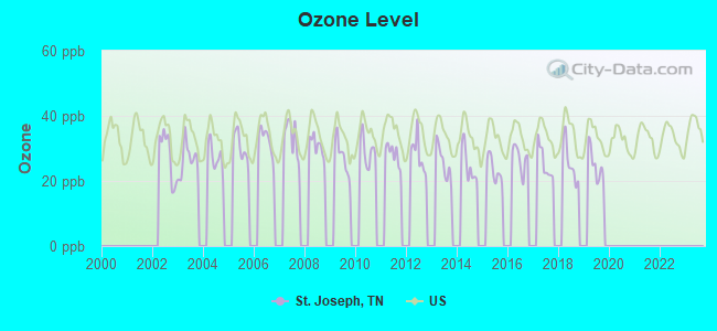
Ozone [ppb] level in 2019 was 24.8. This is better than average. Closest monitor was 20.1 miles away from the city center.
| City: | 24.8 |
| U.S.: | 33.3 |
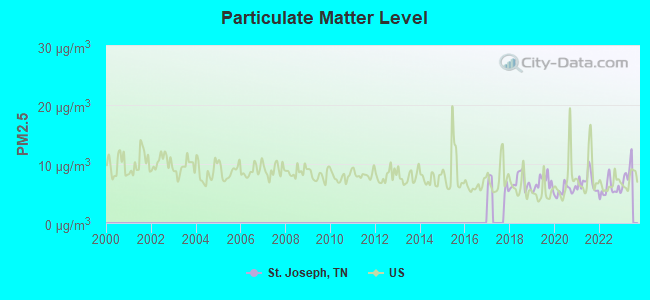
Particulate Matter (PM2.5) [µg/m3] level in 2022 was 5.72. This is significantly better than average. Closest monitor was 5.9 miles away from the city center.
| City: | 5.72 |
| U.S.: | 8.11 |
Tornado activity:
St. Joseph-area historical tornado activity is above Tennessee state average. It is 110% greater than the overall U.S. average.
On 5/18/1995, a category F4 (max. wind speeds 207-260 mph) tornado 2.7 miles away from the St. Joseph city center killed 3 people and injured 32 people and caused between $500,000 and $5,000,000 in damages.
On 4/16/1998, a category F5 (max. wind speeds 261-318 mph) tornado 32.0 miles away from the city center killed 3 people and injured 36 people and caused $13 million in damages.
Earthquake activity:
St. Joseph-area historical earthquake activity is significantly above Tennessee state average. It is 219% greater than the overall U.S. average.On 4/29/2003 at 08:59:39, a magnitude 4.9 (4.4 MB, 4.6 MW, 4.9 LG, Class: Light, Intensity: IV - V) earthquake occurred 112.8 miles away from St. Joseph center
On 1/18/1999 at 07:00:53, a magnitude 4.8 (4.8 MB, 4.0 LG, Depth: 0.6 mi) earthquake occurred 113.6 miles away from the city center
On 4/18/2008 at 09:36:59, a magnitude 5.4 (5.1 MB, 4.8 MS, 5.4 MW, 5.2 MW, Class: Moderate, Intensity: VI - VII) earthquake occurred 237.3 miles away from St. Joseph center
On 3/25/1976 at 00:41:20, a magnitude 5.0 (4.9 MB, 5.0 LG) earthquake occurred 164.7 miles away from the city center
On 5/4/1991 at 01:18:54, a magnitude 5.0 (4.4 MB, 4.6 LG, 5.0 LG, Depth: 3.1 mi) earthquake occurred 167.7 miles away from St. Joseph center
On 9/26/1990 at 13:18:51, a magnitude 5.0 (4.7 MB, 4.8 LG, 5.0 LG, Depth: 7.7 mi) earthquake occurred 186.1 miles away from St. Joseph center
Magnitude types: regional Lg-wave magnitude (LG), body-wave magnitude (MB), surface-wave magnitude (MS), moment magnitude (MW)
Natural disasters:
The number of natural disasters in Lawrence County (20) is greater than the US average (15).Major Disasters (Presidential) Declared: 16
Emergencies Declared: 2
Causes of natural disasters: Floods: 13, Storms: 11, Tornadoes: 8, Winds: 5, Winter Storms: 4, Heavy Rains: 2, Flash Flood: 1, Hurricane: 1, Ice Storm: 1, Landslide: 1, Mudslide: 1, Snowfall: 1, Other: 1 (Note: some incidents may be assigned to more than one category).

Colleges/universities with over 2000 students nearest to St. Joseph:
- University of North Alabama (about 19 miles; Florence, AL; Full-time enrollment: 5,886)
- Northwest-Shoals Community College (about 23 miles; Muscle Shoals, AL; FT enrollment: 2,702)
- Athens State University (about 35 miles; Athens, AL; FT enrollment: 2,771)
- John C Calhoun State Community College (about 41 miles; Tanner, AL; FT enrollment: 7,911)
- Columbia State Community College (about 47 miles; Columbia, TN; FT enrollment: 3,383)
- University of Alabama in Huntsville (about 54 miles; Huntsville, AL; FT enrollment: 6,006)
- Alabama A & M University (about 56 miles; Normal, AL; FT enrollment: 4,524)
Points of interest:
Notable locations in St. Joseph: Saint Joseph Volunteer Fire Department (A), Saint Joseph City Hall (B). Display/hide their locations on the map
Churches in St. Joseph include: Saint Joseph First Baptist Church (A), Saint Joseph Catholic Church (B), Odems Chapel (C), Saint Joseph United Methodist Church (D). Display/hide their locations on the map
Cemeteries: Saint Joseph Cemetery (1), Saint Joseph Catholic Cemetery (2). Display/hide their locations on the map
Park in St. Joseph: Saint Joseph City Park (1). Display/hide its location on the map
Drinking water stations with addresses in St. Joseph and their reported violations in the past:
ST JOSEPH WATER SYSTEM (Population served: 1,352, Groundwater under infl of surface water):Past monitoring violations:
- Monitoring and Reporting (DBP) - Between OCT-2013 and DEC-2013, Contaminant: Total Haloacetic Acids (HAA5). Follow-up actions: St Violation/Reminder Notice (FEB-07-2014), St Public Notif requested (FEB-07-2014)
- Monitoring and Reporting (DBP) - Between OCT-2013 and DEC-2013, Contaminant: TTHM. Follow-up actions: St Violation/Reminder Notice (FEB-07-2014), St Public Notif requested (FEB-07-2014)
- Record Keeping - In APR-28-2009, Contaminant: IESWTR. Follow-up actions: St Public Notif requested (MAY-27-2009), St Violation/Reminder Notice (MAY-27-2009), St AO (w/penalty) issued (OCT-01-2009), St Public Notif received (APR-18-2010), St No addtl Formal Action needed (SEP-30-2011), St Compliance achieved (APR-28-2012)
- Monitoring and Reporting (DBP) - Between APR-2009 and JUN-2009, Contaminant: Chlorine. Follow-up actions: St Public Notif requested (JUL-09-2009), St Violation/Reminder Notice (JUL-09-2009), St Compliance achieved (SEP-30-2009), St AO (w/penalty) issued (OCT-01-2009)
- Monitoring, Turbidity (Enhanced SWTR) - In APR-2005, Contaminant: IESWTR. Follow-up actions: St Public Notif received (APR-22-2005), St Compliance achieved (MAY-01-2005), St Public Notif requested (MAY-31-2005), St Violation/Reminder Notice (MAY-31-2005), St AO (w/penalty) issued (AUG-31-2005)
- One minor monitoring violation
- 3 other older monitoring violations
| This city: | 2.3 people |
| Tennessee: | 2.5 people |
| This city: | 65.7% |
| Whole state: | 67.3% |
| This city: | 2.9% |
| Whole state: | 5.8% |
Likely homosexual households (counted as self-reported same-sex unmarried-partner households)
- Lesbian couples: 0.0% of all households
- Gay men: 0.3% of all households
For population 15 years and over in St. Joseph:
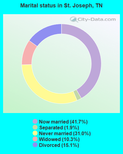
- Never married: 31.0%
- Now married: 41.7%
- Separated: 1.9%
- Widowed: 10.3%
- Divorced: 15.1%
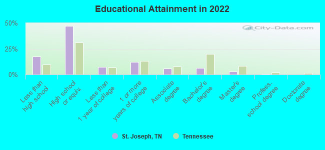
For population 25 years and over in St. Joseph:
- High school or higher: 79.5%
- Bachelor's degree or higher: 9.2%
- Graduate or professional degree: 3.4%
- Unemployed: 7.7%
- Mean travel time to work (commute): 31.0 minutes
| Here: | 13.4 |
| Tennessee average: | 11.4 |
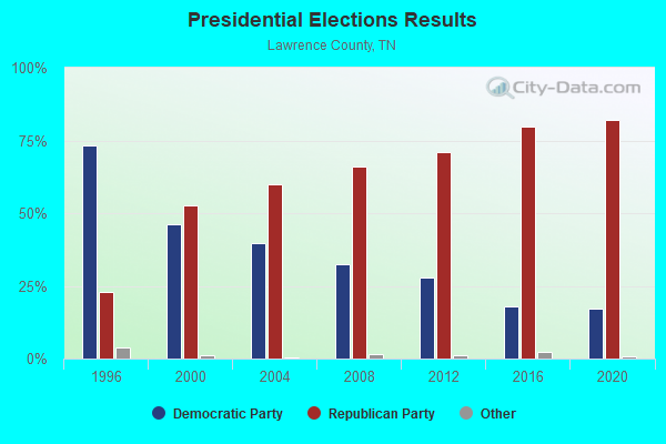
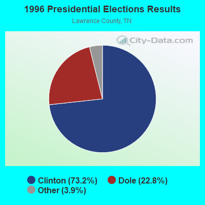
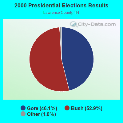
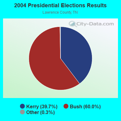
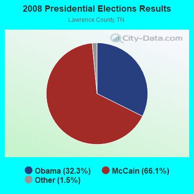
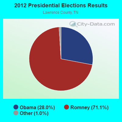
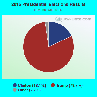

Graphs represent county-level data. Detailed 2008 Election Results
Religion statistics for St. Joseph, TN (based on Lawrence County data)
| Religion | Adherents | Congregations |
|---|---|---|
| Evangelical Protestant | 21,055 | 106 |
| Mainline Protestant | 3,005 | 21 |
| Catholic | 1,200 | 3 |
| Other | 563 | 2 |
| None | 16,046 | - |
Food Environment Statistics:
| This county: | 2.20 / 10,000 pop. |
| State: | 1.99 / 10,000 pop. |
| Lawrence County: | 0.24 / 10,000 pop. |
| Tennessee: | 0.17 / 10,000 pop. |
| Lawrence County: | 1.71 / 10,000 pop. |
| Tennessee: | 0.65 / 10,000 pop. |
| This county: | 7.58 / 10,000 pop. |
| State: | 5.16 / 10,000 pop. |
| This county: | 4.65 / 10,000 pop. |
| Tennessee: | 6.56 / 10,000 pop. |
| Here: | 13.0% |
| State: | 11.4% |
| Lawrence County: | 30.3% |
| Tennessee: | 30.2% |
| This county: | 11.9% |
| Tennessee: | 13.5% |
Health and Nutrition:
| This city: | 49.4% |
| Tennessee: | 49.3% |
| Here: | 46.8% |
| Tennessee: | 46.1% |
| St. Joseph: | 29.6 |
| State: | 28.8 |
| St. Joseph: | 22.6% |
| State: | 21.0% |
| Here: | 16.7% |
| Tennessee: | 10.5% |
| St. Joseph: | 6.8 |
| Tennessee: | 6.8 |
| St. Joseph: | 41.1% |
| Tennessee: | 33.9% |
| St. Joseph: | 54.3% |
| Tennessee: | 55.9% |
| St. Joseph: | 78.3% |
| Tennessee: | 79.1% |
More about Health and Nutrition of St. Joseph, TN Residents
St. Joseph government finances - Expenditure in 2017 (per resident):
- Current Operations - Water Utilities: $75,000 ($92.82)
General - Other: $71,000 ($87.87)
Central Staff Services: $52,000 ($64.36)
Police Protection: $48,000 ($59.41)
Gas Utilities: $44,000 ($54.46)
Electric Utilities: $41,000 ($50.74)
Financial Administration: $11,000 ($13.61)
Local Fire Protection: $6,000 ($7.43)
Judicial and Legal Services: $3,000 ($3.71)
- Gas Utilities - Interest on Debt: $10,000 ($12.38)
- Total Salaries and Wages: $217,000 ($268.56)
St. Joseph government finances - Revenue in 2017 (per resident):
- Miscellaneous - Fines and Forfeits: $90,000 ($111.39)
- Revenue - Water Utilities: $178,000 ($220.30)
Gas Utilities: $139,000 ($172.03)
- State Intergovernmental - Highways: $20,000 ($24.75)
- Tax - Alcoholic Beverage Sales: $99,000 ($122.52)
Property: $62,000 ($76.73)
General Sales and Gross Receipts: $60,000 ($74.26)
Public Utilities Sales: $11,000 ($13.61)
Alcoholic Beverage License: $8,000 ($9.90)
St. Joseph government finances - Debt in 2017 (per resident):
- Long Term Debt - Beginning Outstanding - Unspecified Public Purpose: $384,000 ($475.25)
Outstanding Unspecified Public Purpose: $344,000 ($425.74)
Retired Unspecified Public Purpose: $40,000 ($49.50)
Strongest AM radio stations in St. Joseph:
- WZNN (620 AM; 5 kW; LEXINGTON, AL; Owner: MANUEL HUERTA)
- WLOR (1550 AM; 50 kW; HUNTSVILLE, AL; Owner: BCA RADIO, LLC)
- WSM (650 AM; 50 kW; NASHVILLE, TN; Owner: GAYLORD ENTERTAINMENT COMPANY)
- WVNN (770 AM; 10 kW; ATHENS, AL; Owner: ATHENS BROADCASTING COMPANY, INC.)
- WVNA (1590 AM; 5 kW; TUSCUMBIA, AL; Owner: CLEAR CHANNEL BROADCASTING LICENSES, INC.)
- WBXR (1140 AM; daytime; 15 kW; HAZEL GREEN, AL; Owner: LOW COUNTRY CORPORATION, INC.)
- WAMB (1160 AM; 50 kW; DONELSON, TN; Owner: GREAT SOUTHERN BROADCASTING COMPANY, INC.)
- WKDA (1200 AM; 50 kW; NASHVILLE, TN; Owner: RADIO NASHVILLE, INC.)
- WJOX (690 AM; 50 kW; BIRMINGHAM, AL; Owner: CITADEL BROADCASTING COMPANY)
- WWAM (820 AM; daytime; 50 kW; JASPER, TN; Owner: SHELTON BROADCASTING SYSTEM)
- WDJC (850 AM; 50 kW; BIRMINGHAM, AL; Owner: KIMTRON, INC.)
- WNQM (1300 AM; 50 kW; NASHVILLE, TN; Owner: WNQM. INC.)
- WKAC (1080 AM; daytime; 5 kW; ATHENS, AL; Owner: LIMESTONE BROADCASTING COMPANY, INC.)
Strongest FM radio stations in St. Joseph:
- WJOR-FM (101.5 FM; ST. JOSEPH, TN; Owner: CLEAR CHANNEL BROADCASTING LICENSES, INC.)
- W226AF (93.1 FM; LORETTO, TN; Owner: PROSPECT COMMUNICATIONS)
- W254AA (98.7 FM; COLBERT HEIGHTS, AL; Owner: WILLIAM P. ROGERS)
- WYTK (93.9 FM; ROGERSVILLE, AL; Owner: SHOALS BROADCASTING CORPORATION)
- WLAY-FM (100.3 FM; TUSCUMBIA, AL; Owner: CLEAR CHANNEL BROADCASTING LICENSES, INC.)
- WQLT-FM (107.3 FM; FLORENCE, AL; Owner: BIG RIVER BROADCASTING CORPORATION)
- WMSR-FM (94.9 FM; COLLINWOOD, TN; Owner: OHIO BROADCAST ASSOCIATES)
- WFIX (91.3 FM; FLORENCE, AL; Owner: TRI-STATE INSPIRATIONAL B/C CORP.)
- WEUZ (92.1 FM; MINOR HILL, TN; Owner: BROADCAST ONE, INC.)
- W287AA (105.3 FM; LAWRENCEBURG, TN; Owner: WAY-FM MEDIA GROUP, INC.)
- W202BY (88.3 FM; KILLEN, AL; Owner: WAY-FM MEDIA GROUP, INC.)
- WXFL (96.1 FM; FLORENCE, AL; Owner: BIG RIVER BROADCASTING CORP.)
- WLLX (97.5 FM; LAWRENCEBURG, TN; Owner: ROGER WRIGHT DBA PROSPECT COMMUNICATIONS)
- WVNA-FM (105.5 FM; MUSCLE SHOALS, AL; Owner: CLEAR CHANNEL BROADCASTING LICENSES, INC.)
- WBTG-FM (106.3 FM; SHEFFIELD, AL; Owner: SLATTON & ASSOCS. BROADCASTERS, INC.)
- WAHR (99.1 FM; HUNTSVILLE, AL; Owner: BCA RADIO, LLC)
- WZYP (104.3 FM; ATHENS, AL; Owner: ATHENS BROADCASTING COMPANY, INC.)
- W278AA (103.5 FM; MADISON, AL; Owner: TENNESSEE VALLEY RADIO, INC.)
- WAKD (89.9 FM; SHEFFIELD, AL; Owner: AMERICAN FAMILY ASSOCIATION)
- WMXV (103.5 FM; RUSSELLVILLE, AL; Owner: CLEAR CHANNEL BROADCASTING LICENSES, INC.)
TV broadcast stations around St. Joseph:
- WHDF (Channel 15; FLORENCE, AL; Owner: VALLEY TELEVISION, LLC)
- WXFL-LP (Channel 5; FLORENCE, ETC., AL; Owner: BENNY CARLE BROADCASTING, INC.)
- WBCF-LP (Channel 3; FLORENCE, AL; Owner: BENNY CARLE BROADCASTING, INC.)
- W57BV (Channel 57; FLORENCE, AL; Owner: TRINITY BROADCASTING NETWORK)
- WYLE (Channel 26; FLORENCE, AL; Owner: ETC COMMUNICATIONS INC.)
- St. Joseph, Tennessee
- Fatal accident count8
- Vehicles involved in fatal accidents13
- Fatal accidents involving drunk persons:3
- Fatalities10
- Persons involved in fatal accidents21
- Pedestrians involved in fatal accidents1
- Tennessee average
- Fatal accident count8336
- Vehicles involved in fatal accidents12503
- Fatal accidents involving drunk persons2984
- Fatalities9209
- Persons involved in fatal accidents20420
- Pedestrians involved in fatal accidents981
- National Bridge Inventory (NBI) Statistics
- 7Number of bridges
- 82ft / 25.1mTotal length
- $1,248,000Total costs
- 3,184Total average daily traffic
- 118Total average daily truck traffic
- 5,094Total future (year 2041) average daily traffic
- 55.4%Electricity
- 31.4%Utility gas
- 11.6%Wood
- 1.7%Bottled, tank, or LP gas

- 66.7%Electricity
- 29.6%Utility gas
- 3.7%Wood
St. Joseph compared to Tennessee state average:
- Median household income below state average.
- Median house value below state average.
- Unemployed percentage below state average.
- Black race population percentage significantly below state average.
- Hispanic race population percentage significantly below state average.
- Median age above state average.
- Foreign-born population percentage below state average.
- Renting percentage below state average.
- Length of stay since moving in significantly above state average.
- House age above state average.
- Percentage of population with a bachelor's degree or higher significantly below state average.